#Drought news January 12, 2023: Areas of 1-Class degradation in S.E. #Colorado

Click on a thumbnail graphic to view a gallery of drought data from the US Drought Monitor website.

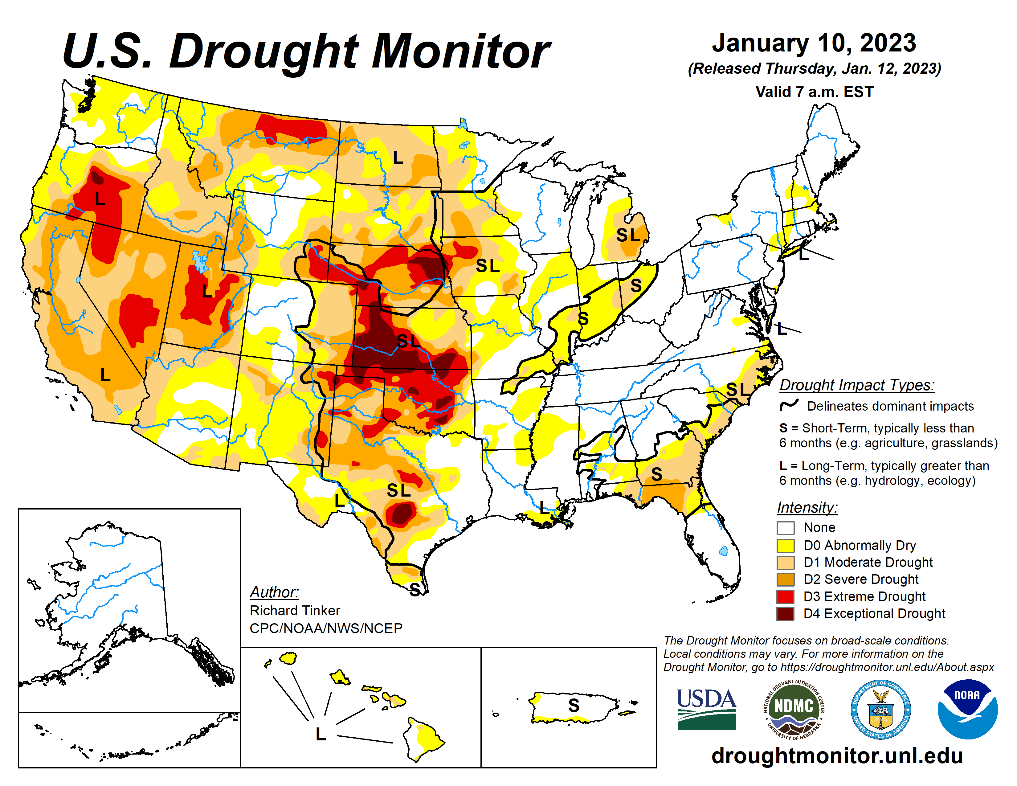
Click the link to go to the US Drought Monitor website. Here’s an excerpt:

This Week’s Drought Summary

A series of atmospheric rivers (AR) led to heavy rain and high-elevation snow across parts of the West, especially across California. Precipitation totals exceeding 4 inches (liquid-equivalent) were widespread, and several areas in and near the Sierra Nevada, Cascades, and coastal ranges recorded over one foot of precipitation. Moderate to heavy precipitation was also common along the coast and in the higher elevations of the Pacific Northwest, some higher elevations in the central and northern Rockies, part of the upper Midwest, portions of the lower Mississippi Valley, the interior Southeast, and scattered locales across the Ohio Valley and the Northeast. Precipitation totals generally exceeded 1.5 inches, and topped 4 inches in parts of the Southeast, central Utah, and the higher elevations in the Pacific Northwest. Much of the precipitation fell on areas experiencing dryness and drought, so across the country, improvement was much more common than deterioration. Mild temperatures prevailed across the country except where significant precipitation was observed in the northern Plains and Far West. Daily high temperatures averaged more than 12 deg. F above normal in central and southern Texas while daily low temperatures averaged 10 to 13 deg. F above normal across the Great Lakes, the Southeast, and the southern Plains…
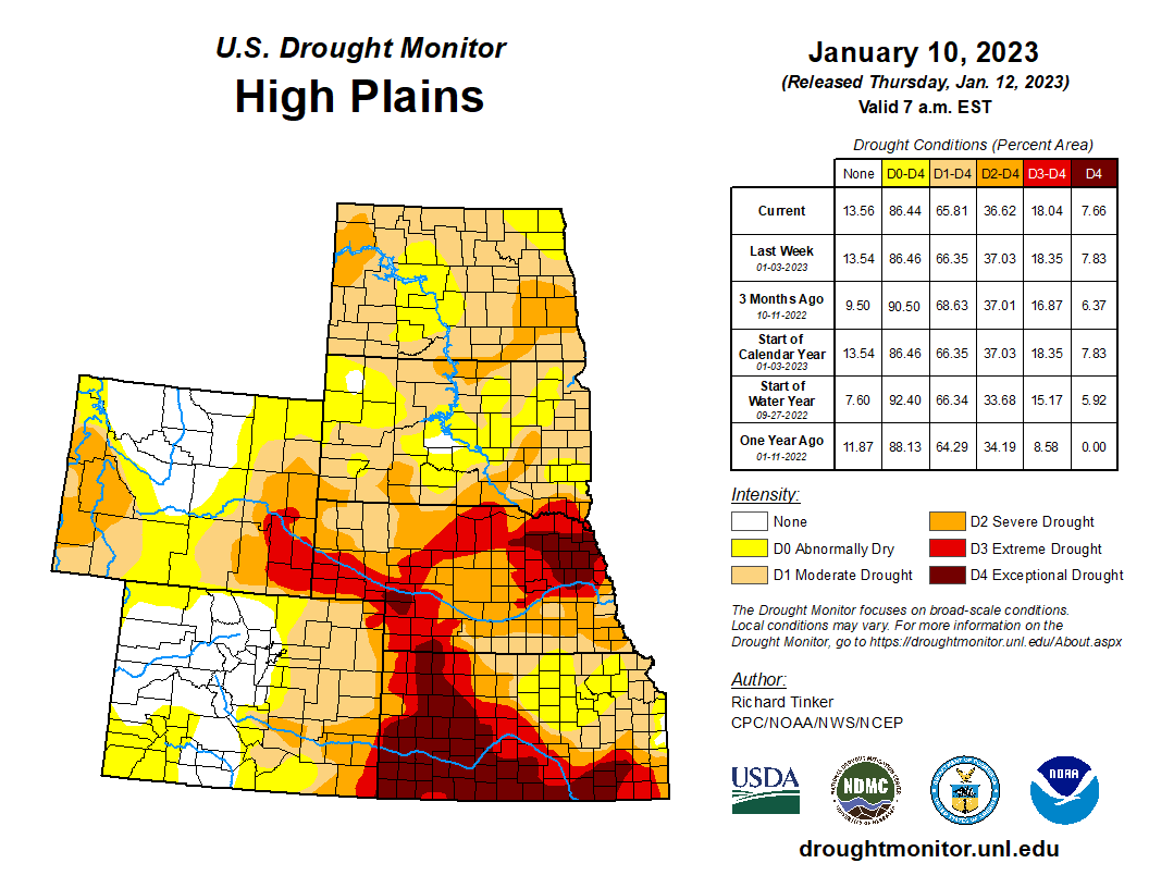
High Plains

Most of the Region was much drier than the prior week, with a few tenths of an inch of precipitation restricted to southeastern South Dakota and adjacent portions of Nebraska, as well as isolated sites in the higher elevations of Colorado and southern Wyoming. Other areas recorded little if any precipitation. Most of the region remained unchanged from last week, but some improvement occurred in southeastern South Dakota and adjacent Nebraska. No areas appeared to deteriorate significantly due to the heavy precipitation of the previous week and seasonably cold temperatures reducing human and natural water demand. But most of the region remained in at least moderate drought (D1), with extreme to exceptional drought (D3-D4) stretching from southeastern Wyoming eastward across most of Nebraska into adjacent Iowa, and southward from western Nebraska through most of southern and western Kansas. A broad swath covering the southwestern half of Kansas and much of northeastern Nebraska remained in exceptional drought (D4)…
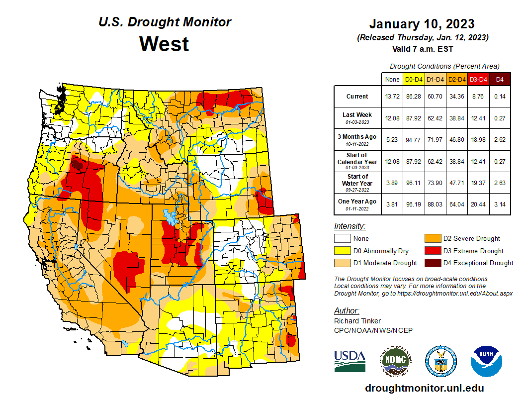
Colorado Drought Monitor one week change map ending January 10, 2023.

West

A long-term drought, dating back to the 2019-2020 winter, continues across California, the Great Basin, and parts of the Pacific Northwest. However, the intense precipitation in California the past few weeks – particularly late December and early January – has significantly reduced drought intensity in California. Most of the state saw a 1-category improvement this week. The D3 across interior northern and central California that covered over 35 percent of the state two weeks ago, is now confined to a small area adjacent to Oregon. But Despite the record and near-record precipitation over the past 6 weeks, large parts of the state remain in D1-D2 since moisture deficits have been entrenched across some areas for the last 2-3 years. At least one-third of the state has been in drought (D1+) since February 2020…

South

Moderate to locally heavy rain in Tennessee and Mississippi kept those states free from drought. The small area of D0 remaining in Tennessee was removed, and D0 areas in Mississippi contracted slightly. Moderate to locally heavy rain also fell on most of Louisiana and eastern Texas, reducing the extent of D0 in northern Louisiana and improving the west side of the D0 and D1 areas in the Bayou. Farther west, little or no precipitation fell. Exacerbated by much above normal temperatures, conditions deteriorated in portions of Texas and Oklahoma, although most locations were unchanged by the week’s dryness. Much of Oklahoma remained in extreme drought (D3), and similarly dry conditions existed across scattered areas in central and northern Texas. Exceptional drought (D4) now covers part of central Texas, scattered areas across Oklahoma, along with the northern tier of the state. 90-day precipitation amounts were only 10 to 25 percent of normal through the Oklahoma Panhandle, part of adjacent Texas, and in far western Texas from Big Bend National Park northwestward for a few hundred miles along the Rio Grande. Locations in and near the central Texas D4 region recorded 3 to 5 inches less precipitation than normal during this period…

Looking Ahead

During the next five days (January 12-16) more heavy precipitation is expected across California, with parts of the Sierra Nevada, Cascades and northwestern California expected to receive another 4 to 7 inches of rain. Similar amounts are forecast for parts of the immediate Oregon coastline, the Washington Cascades, and northwestern Washington, where normal amounts are much higher than across most of California. From the Great Basin and Intermountain West to the Mississippi River, conditions should be much more tranquil, with 0.5 to 1.5 inch restricted to some higher elevations in the central and southern Rockies and the Middle Mississippi Valley. Little or no precipitation is anticipated throughout the Plains. Meanwhile, a swath from the Ohio/Mississippi Confluence and the interior Southeast northeastward through New England is expected to receive at least 0.5 inch, with totals topping 1.5 inches in parts of Upstate New York and New England. Light amounts are expected in the Great Lakes Region, the upper Midwest, the South Atlantic coastal plains, and most of Florida. Temperatures throughout the contiguous states are expected to be near- or above-normal.

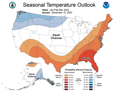
The Climate Prediction Center’s 6-10 day outlook (valid Jan 17-21) shows above-normal precipitation favored over the vast majority of the contiguous states, and in southeastern Alaska. Chances exceed 60 percent that amounts will be in the wettest one-third of the historical distribution from northern California and adjacent Oregon eastward across northern Utah, and across the middle Mississippi, lower Ohio, and Tennessee River Valleys. Subnormal precipitation is only favored in a small strip along the Rio Grande in southwestern Texas, and no tilt of the odds in either direction were identified in the northern High Plains, the southwestern half of Texas, and southern Florida. Above-normal temperatures are expected across the central and eastern parts of the country, with the highest odds (over 80 percent) in the Northeast, the mid-Atlantic Region, the eastern Great Lakes, the Ohio Valley, southern Appalachia, the Carolinas, and northern Georgia. Meanwhile, below-normal temperatures are expected from the Great Basin and central Rockies southward to the Mexican border, with the best chances (over 60 percent) in the desert Southwest and adjacent southern Rockies.

US Drought Monitor one week change map ending January 10, 2023.

Record #drought gripped much of the U.S. in 2022: Nation struck with 18 billion-dollar disasters — NOAA #ActOnClimate

Bath tub ring seen at Lake Mead Marina on Wednesday , Aug. 17, 2022. (Jeff Scheid/Nevada Independent)

Click the link to read the article on the NOAA website (John Bateman):

The large coverage and long duration of drought conditions across the U.S. set several records in 2022.

The year was also marked by numerous severe weather events, devastating hurricanes and deadly flooding across parts of the country.  

Here is a summary of the climate and extreme weather events across the U.S. in 2022:

Climate by the numbers

2022 

The average annual temperature across the contiguous U.S. was 53.4 degrees F — 1.4 degrees above the 20th-century average — ranking in the warmest third of the 128-year record. 

Florida and Rhode Island both saw their fifth-warmest calendar year on record while Massachusetts ranked sixth warmest. Four additional states experienced a top-10 warmest year on record — California, Connecticut, Maine and New Hampshire. Alaska saw its 16th-warmest year in the 98-year record for the state.

Annual precipitation across the contiguous U.S. totaled 28.35 inches (1.59 inches below average), which placed 2022 in the driest third of the climate record. Nebraska saw its fourth-driest year on record while California had its ninth driest. Meanwhile, above-average precipitation caused Alaska to have its fourth-wettest year on record.

Drought coverage across the contiguous U.S. remained significant for the second year in a row, with a minimum extent of 44% occurring on September 6 and a maximum coverage of 63% on October 25 — the largest contiguous U.S. footprint since the drought of 2012. 

In the western U.S., drought conditions reached a peak coverage of 91.3% of the region on May 3. Drought coverage across the West shrank as the summer monsoon reduced some of the coverage in the Southwest. The multi-year western U.S. drought resulted in water stress/shortages across many locations in 2022 as some major reservoirs dropped to their lowest levels on record.

Billion-dollar disasters in 2022

Map of the U.S. plotted with 18 separate billion dollar disasters that occurred in 2022. For more, go to https://www.ncdc.noaa.gov/billions/. (NOAA/NCEI)

Last year, the U.S. experienced 18 separate billion-dollar weather and climate disasters, leading to the deaths of at least 474 people. The following 18 events, each exceeding $1 billion, put 2022 in third place (tied with 2011 and 2017) for the highest number of disasters recorded in a calendar year, behind 2021 — with 20 events — and 2020, with a record 22 separate billion-dollar events:

  • One winter storm/cold wave event (across the central and eastern U.S.).
  • One wildfire event (wildfires across the western U.S., including Alaska).
  • One drought and heat wave event (across the western and central U.S.).
  • One flooding event (in Missouri and Kentucky).
  • Two tornado outbreaks (across the southern and southeastern U.S.).
  • Three tropical cyclones (Fiona, Ian and Nicole).
  • Nine severe weather/hail events (across many parts of the country, including a derecho in the central U.S). 

Damages from these disasters totaled approximately $165.0 billion for all 18 events. This surpasses 2021 ($155.3 billion, inflation adjusted) in total costs, which makes 2022 the third most costly year on record, only behind 2017 and 2005; all inflation adjusted to 2022 dollars).  

Hurricane Ian was the most costly event of 2022 at $112.9 billion, and ranks as the third most costly hurricane on record (since 1980) for the U.S., behind Hurricane Katrina (2005) and Hurricane Harvey (2017).

Over the last seven years (2016-2022), 122 separate billion-dollar disasters have killed at least 5,000 people, with a total cost of more than $1 trillion in damages. Five of the last six years (2017-2022, with 2019 being the exception) have each had a price tag of at least $100 billion.

Other notable climate and weather events in 2022

A map of the U.S. plotted with significant climate events that occurred throughout 2022. Credit: NOAA

An average but destructive hurricane season: During 2022, 14 named storms formed in the North Atlantic Basin (four tropical storms, eight hurricanes and two major hurricanes), which is near the historical average. Several notable storms brought destruction and flooding to portions of the U.S. 

Hurricane Fiona brought massive flooding to Puerto Rico, with some areas receiving 12-18 inches of rain. Hurricane Ian, with 150 mph sustained winds, made landfall in southwest Florida resulting in major flooding, damage and loss of life. Later in the year, Hurricane Nicole made landfall along Florida’s eastern shore, flooding the coast and knocking out power for hundreds of thousands of people. Nicole was the first hurricane to hit the U.S. during November in nearly 40 years.

An above-average tornado year: The preliminary U.S. tornado count for 2022 was approximately 9% above the 1991-2020 average across the contiguous U.S. with 1,331 tornadoes reported. March 2022 had triple the average number of tornadoes reported (293) and the most tornadoes reported for any March in the 1950-2022 record.

Wildfires scorched the West, Alaska: In addition to the active wildfire year across the western U.S., Alaska saw one million acres burned by June 18 — the earliest such occurrence in a calendar year than any other time in the last 32 years. By July 1, 1.85 million acres had been consumed — the second-highest June total on record and the seventh-highest acreage burned for any calendar month on record for Alaska.

More: Find NOAA’s climate reports and download the images from the NCEI climate monitoring website.

Ribbon-cutting, blessings, #water bubbles open new Hydro building:  New home for water quality lab opens new horizons for innovation, research and teaching — @DenverWater 

A ribbon-cutting ceremony for the Hydro building on Jan. 6, 2023, marked the completion of the CSU Spur campus, a center for innovation and learning focused on water, land and life. Photo credit: CSU Spur.

Click the link to read the post on the Denver Water website (Cathy Proctor):

Colorado State University’s marching band, university mascot CAM the Ram and the enthusiastic clamor of cowbells joined with dignitaries from the city, state and nation on Friday to celebrate the opening of the new Hydro building at the CSU Spur campus in north Denver. 

The Hydro building will be the home of Denver Water’s new, state-of-the-art water quality laboratory, replacing a small and outdated facility in southwest Denver that Denver Water had outgrown. 

It’s the third of a three-building research innovation and education complex called CSU Spur built at the heart of the National Western Center, the historic site of the old stock show complex now undergoing a massive redevelopment effort

See inside the Hydro building, which opened on Friday, Jan. 6:

Denver Water is partnering with Colorado State University to be part of the new CSU Spur campus on the National Western Center campus. Learn about Denver Water’s role at the new building.

Prior to cutting the ribbon to open the new building, Denver Water CEO/Manager Jim Lochhead noted that the building offers far more than laboratory space, which is expected to be fully operational later this spring. 

“Here at CSU’s Spur campus, Denver Water will be the heart of a new research environment where we can work closely with academics and scientists in planning for water demands and challenges of tomorrow,” Lochhead said. 

“Climate change and emerging water quality issues require innovation. Spur provides a collaborative opportunity with all water interests to help Denver Water provide leading solutions to water challenges for our customers, the state and the West in a public and engaging way,” he said. 

One of the exhibits in the Hydro building provides a hands-on demonstration of how moving water, such as a river, shapes the land around it over time. Photo credit: CSU Spur

The utility’s water quality team conducts nearly 200,000 tests every year to ensure the water delivered to 1.5 million people every day is clean, safe and meets all state and federal water quality standards. The new facility provides room for Denver Water scientists to test three times that amount in the future. 

Denver Water’s Youth Education team also will use the site to teach students about their water — where it comes from, how it’s cleaned and how its delivered to their homes. 

“This space also provides us with new ways to connect with the next generation of water leaders and highlight career paths that many students may not have been aware of before. It’s a win for all of us,” Lochhead said. 

The connections created by the people working at the CSU Spur campus will be “a win for all of us,” said Jim Lochhead, the CEO/Manager of Denver Water. Photo credit: Denver Water.

Hydro, which is Greek for water, joins two completed buildings at the CSU Spur campus. 

The first building, Vida, which means “life” in Spanish, opened in January 2022. It’s home to a community veterinary hospital for the Dumb Friends League; Temple Grandin Equine Center, which offers equine assisted services; and a 9-foot model of a kitten named Esperanza, quite possibly the largest cat in the West. 

The second building, Terra, which means “earth” or “land” in Latin, opened in the summer of 2022. It features rooftop greenhouses and a teaching kitchen, along with food innovation labs for new product creation, agricultural diagnostic labs and exhibits focused on food and agricultural systems.

The intersection of those three areas — water, land and life — represent the global challenges facing our world. 

“I don’t think we can imagine what will be accomplished in the next 20, 40, 50 years at this campus. But I believe when we think about the human potential that will be unlocked here, the creativity that will be unleashed to make progress around these great global challenges, CSU Spur is something we’ll be incredibly proud to be a part of,” said Tony Frank, the chancellor of the Colorado State University System, at the opening ceremony. 

Terra, one of the three buildings at the CSU Spur campus, focuses on agriculture and has a teaching kitchen. Photo credit: CSU Spur.

The connections the three buildings will foster — between people dedicated to public health and animal care, the land and the food it provides, and the life-giving water that circulates throughout — was noted by several speakers during the ceremony. 

Denver Mayor Michael Hancock said Denver Water’s presence at the building, with its water quality experts, will feature the mission of Hydro — to bring research and innovation to the questions of water resilience and sustainability. 

Tom Vilsack, the U.S. Secretary of Agriculture, has been involved in the planning for the CSU Spur campus for years. The end of construction means the start of opportunity and change on a local and international level, he told the crowd. 

“These buildings are not just buildings. They’re not just incredible educational opportunities. They’re not just a place to celebrate the science and arts. They’re not just a place to connect rural and urban,” Vilsack said. 

“This is the center of transformation. This is a center for a brighter and better future, not just for Colorado agriculture, not just for United States agriculture, but for global agriculture. It’s that important what you all are doing here. 

“I hope as you go through here, you understand and appreciate how proud you should be to be connected to a university, to a city, and to a state that is so committed to this endeavor,” he said. 

The Vida building at the CSU Spur campus has a veterinary clinic for professionals, and a learning space for students exploring future opportunities. Photo credit: CSU Spur.

Colorado Gov. Jared Polis said he viewed the campus and the connections it will foster as a place that will drive the state’s economy and sustainability efforts. 

“Water is life in our state, and the challenges that Colorado and the West face around water are really reaching a critical point in less water, more demand, our straining of our streams and our waterways, making the work here, inventing innovative, a future that works for the West, that works for Colorado is more important than ever before,” Polis said. 

“This is a place where we can continue our leadership on water, fostering conversations that lead to local, regional, statewide solutions.”

After the ribbon was cut, all three buildings were open to the public. 

Children, parents and adults walked through Hydro, learning about the importance of water from Denver Water employees who staffed the “Water and Land” hands-on exhibit demonstrating how moving water, such as a river, shapes the land around it. 

On the third floor of the building, they peered through the glass at the new laboratory space that will be set up and operational in coming months. And they gathered around a column of water, watching bubbles rise through the water and using an information table to explore different indicators that scientists look for to determine water quality. 

Interactive exhibits explore the world of water at the Hydro building. Photo credit: Denver Water.

At the Terra building, students explored food options, while at Vida they learned about veterinary care – even trying on lab coats while bandaging a stuffed dog. 

Before the celebration, John Gritts, a member of the Cherokee Nation, blessed the building:

“Creator, as we gather here today to open and celebrate Hydro, the last building in this educational complex, we ask for your blessings upon this sacred ground,” Gritts said. 

“We ask for your blessings for this place where people can learn the importance of the relationship between animals, plants — and how sacred water is to us as human beings. May we recognize and honor those relationships. 

“Thank you for this day that we can celebrate.”

John Gritts, a member of the Cherokee Nation, sought a blessing for the Hydro building prior to its opening on Jan. 6, 2023. Photo credit: CSU Spur.

The #Colorado #Water Conservation Board invites you to celebrate the launch of the 2023 Colorado Water Plan! — @CWCB_DNR #COWaterPlan

The December 2022 #climate summary is hot off the presses from Western #Water Assessment

Click the link to access the Intermountain West Climate Dashboard on the Western Water Assessment website:

Latest Briefing

January 10, 2023 – CO, UT, WY

Lots of snow and favorable water supply forecasts are the December climate headliner. Snowpack is above average for nearly the entire region with statewide SWE ranging from 116% normal in Colorado to 132% in Wyoming to 155% in Utah. Regional precipitation was generally above average and temperatures were below average during December. January 1st seasonal streamflow forecasts are near-to-above average except for the river basins east of the Continental Divide in Colorado, where forecasts are below average. Neutral ENSO conditions are expected to form by late winter and there is an increased probability of above average January precipitation throughout the region.

Precipitation was above to much-above average for much of the Intermountain West during December. Large areas of Colorado, Utah and western Wyoming received greater than 150% of average December precipitation. Some locations in south-central Wyoming experienced the wettest December on record. Southeastern Colorado, northwestern Utah and southeastern Wyoming received below average precipitation. Precipitation from strong atmospheric rivers comprised the majority of December precipitation at many locations. For most regional mountain locations, water year precipitation is near-to-above normal.

For the third month in a row, regional temperatures were mostly below average. December temperatures below normal in Wyoming and slightly below normal in northern Colorado and northern Utah. Southern Colorado and southern Utah experienced slightly above normal temperatures. Below normal temperatures were observed in the first three months of the water year (October-December) in the entire region for the first time since 2019.

Regional snowpack was above to much-above average for all river basins except the Arkansas (70%) and Rio Grande (77%). As of January 1st, statewide snow water equivalent was highest in Utah (155%) and much above average in Wyoming (132%) and above average in Colorado (116%). Over the last 20 years in Utah, January 1st percent normal SWE was higher only in 2005 and 2011; both of these water years ended with SWE at greater than 150% of normal. Significant snowfall during the first three days of January led to higher percent normal SWE values in the westwide snotel map from 1/3/23 compared to the SWE by basin table. Notably, the Arkansas (80%) and Rio Grande (89%) River basins crept closer to average by January 3rd.

January 1st seasonal streamflow forecasts in the Upper Colorado River and Great Basins are near-to-above normal. Near-normal seasonal streamflow volumes (90-110%) are forecasted for the Upper Bear, Colorado, Dolores, Upper Green, Gunnison, San Juan, Sevier and Virgin Rivers. Above normal seasonal streamflow (110-120%) is forecasted for the Lower Bear, Lower Green, White and Yampa River basins. Much-above normal seasonal streamflow (>130%) is forecasted for the Provo River, Weber River and Six Creeks basins. Seasonal streamflow forecasts for all large Upper Colorado River Basin reservoirs are near normal and Lake Powell’s inflow forecast is 105% of normal. East of the Continental Divide in Colorado, seasonal streamflow forecasts are below normal for the Arkansas and Rio Grande Rivers and much-below normal for the South Platte River. Wyoming seasonal streamflow forecasts near-to-slightly above normal for all river basins. While late fall soil moisture remained below normal for much of the region, above normal precipitation and below normal temperatures since October 1st led to favorable streamflow forecasts. It is important to note that there is still three months of the snow accumulation season left and January 1st streamflow forecasts contain significant uncertainty. As observed  in 2022, water supply conditions can change dramatically from January to April.

Regional drought conditions improved slightly during December. On January 3rd, drought covered 58% of Colorado, Utah and Wyoming, down from 66% in late November. Drought remains across all of Utah, but significant removal of extreme drought conditions occurred during December. Extreme drought coverage in Utah decreased from 50% in late November to 27% on January 3rd. Drought conditions remain in about 50% of Colorado and Wyoming, but some portions of extreme drought were removed in eastern Colorado and there was a one category improvement in drought conditions across the northern half of Colorado.

La Niña conditions persisted during December, but all ocean temperature models forecast warming waters in the eastern Pacific Ocean. There is a 65% probability of La Niña conditions continuing through February, but neutral ENSO conditions are forecasted for spring and summer (60-80% probability). There are some signs that El Niño conditions may form during fall 2023. The NOAA January precipitation outlook suggests an increased probability of above average precipitation for most of the region, especially in eastern Wyoming. The NOAA seasonal outlook for January-March suggests an increased probability of above average precipitation for northern Wyoming and below normal precipitation for southern Utah and much of Colorado. There are equal chances of above or below normal temperatures for most of the region from January to March.

Significant December weather event. Severe cold wave. A strong Arctic cold front brought extreme winds, cold temperatures and record-hourly temperature decreases to the region on 12/21-12/23. Extremely high pre-frontal winds battered the Wasatch Mountains. At 11,000 feet on Hidden Peak, east of Salt Lake City, winds blew above hurricane force for 14 hours with peak hourly wind speeds of 88 mph, gusting to 124 mph. Elsewhere in the Wasatch Mountains, winds peaked at 80-100 mph. Further east, the intense Arctic cold front caused record hourly temperature decreases. Record hourly temperature decreases occurred with frontal passage in Cheyenne (40ºF), Denver (37º.1F) and Fort Collins (42.3ºF). In Cheyenne, the temperature dropped 32ºF in 9 minutes and 51ºF in 2 hours. Intense snow squalls associated with the cold front created blizzard conditions and closed highways along the Front Range and in eastern Wyoming.

Daily record low temperatures and daily record low maximum temperatures were observed in Colorado and Wyoming on 12/22-12/23. In Wyoming, all-time minimum temperature records were set in Atlantic City (-36ºF), Casper (-42ºF), Midwest (-42ºF) and Powder River (-40ºF). All-time low maximum temperature records were set in Atlantic City (-15ºF), Powder River (-13ºF), Shoshoni (-12ºF) and Worland (-20F), Wyoming. Limón, CO set an all-time low maximum temperature of -10ºF on 12/23. Daly record minimum and minimum maximum temperatures were set across Colorado and Wyoming on 12/22 (22 records) and 12/23 (47 records). Only locations with at least 60 years of weather data were considered for this analysis.  

Key Milestones Hit at Chimney Hollow Reservoir in 2022 — @Northern_Water #ColoradoRiver #COriver #SouthPlatteRiver

Inlet/Outlet Tunnel (left), Bald Mountain Interconnect (center) and Main Dam (right). Credit: Northern Water

From the Chimney Hollow “E-Newsletter” from Northern Water:

Chimney Hollow Reservoir construction crews made significant progress in 2022. Work started in August 2021 and is scheduled to continue until August 2025. Here are some highlights from this year’s work. 

Main Dam Foundation Prep: In November 2022, crews completed the main dam rock excavation, which marked a huge milestone in reservoir construction after 15 months of work on this component. 

Hydraulic Asphalt Core: Chimney Hollow construction crews began the asphalt placement in October 2022. For the next two years, the asphalt will be placed in 9-inch increments per lift until the dam reaches a height of about 350 feet. Rockfill and filter/drain construction occur concurrently to complete the embankment construction at any given elevation. 

Bald Mountain Interconnect: One of the most time-sensitive aspects of the Chimney Hollow Reservoir Project was the Bald Mountain Interconnect. A shutdown of the Colorado-Big Thompson (C-BT) Project occurred from mid-September through mid-December as crews cut into existing infrastructure to tie in a 126-inch diameter section of steel pipe with a 72-inch diameter steel offtake (known as a wye) to add the ability to deliver water into Chimney Hollow Reservoir from the C-BT Project.  

Larimer County and Saddle Dam Access Roads: On Nov. 15, the Larimer County and saddle dam access roads were completed. When the reservoir opens to the public, the Larimer County access road will be the entry road to Chimney Hollow’s future public recreation and open space facilities. The saddle dam road is not a public road and extends to the saddle dam for Northern Water maintenance access.  

Downstream Tunnel and Valve Chamber: The downstream tunnel portal and excavation of the 26-foot diameter downstream portion of the tunnel, which runs 667 feet to the center of the main dam was completed in October 2022. A 30-foot diameter valve chamber was also excavated to provide room for mechanical equipment installation and maintenance. A 72-inch diameter steel conduit will be placed inside the tunnel to bring water in and out of Chimney Hollow Reservoir. 

Northern Water’s Joe Donnelly and Jeff Drager explain in this video how the new 90,000 acre-foot Chimney Hollow Reservoir, located southwest of Loveland, will be filled with water once construction is completed in 2025.

Say hello to the EPA “PFAS Analytics” website

Screenshot of EPA PFAS Analytics website interactive map for Region 8 January 11, 2023.

Click the link to access the EPA website:

This page contains location-specific information related to PFAS manufacture, release, and occurrence in the environment as well as facilities potentially handling PFAS:

The #snowpack continues to look good across much of the West (January 9, 2023) — @DroughtCenter

Recent atmospheric rivers have put California’s San Joaquin watershed up to 274% of normal. Nevada and Utah are also in good shape. But the coastal Washington and Oregon watersheds are struggling a bit more.

Romancing the River: Quo Vadimus 2 — Sibley’s Rivers #GilaRiver #ColoradoRiver #COriver #aridification

Palm Lake at Hassayampa River Preserve, East side of Wickenburg, Arizona. By John Menard from Phoenix, USA – Palm Lake at Hassayampa River PreserveUploaded by PDTillman, CC BY-SA 2.0, https://commons.wikimedia.org/w/index.php?curid=11769047

Click the link to read the article on the Sibley’s Rivers website (George Sibley):

That fabled Hassayampa is in the news these days, down in Arizona. The Hassayampa River does exist, by the way: an intermittent stream that flows off the south slopes of the Colorado Plateau, and down through a desert valley west of the sprawling phenomenon of Phoenix, where it joins the Gila River, which in turn joins the Colorado River down near Yuma and the Mexican border.

A new development has been proposed for the lower Hassayampa Valley, catering to those trying to stay out ahead of the sprawl: the Howard Hughes Corporation wants to turn 37,000 acres of Sonoran desert land there, just west of the White Tank Mountains, into a new development, Teravalis, with 100,000 homes for maybe 300,000 people, and 55 million square feet of commercial space. According to a story in the New York Times, ‘Teravalis is seen by local and state leaders as a crowning achievement in a booming real estate market.’

Arizona Rivers Map via Geology.com.

Truly someone has been drinking from the fabled Hassayampa. Teravalis, in fact, plans to tap an aquifer under the Hassayampa Basin for a water supply for this massive development; they will all be drinking from the Hassayampa. Some Arizonans have, however, looked at the naked facts about water supplies in the desert, and the Phoenix area has a law in effect stating that every development has to show evidence that it has a 100-year water supply, and can replace groundwater it consumes. This law was mandated back in 1980 by the Interior Department, as a condition for funding and constructing the Central Arizona Project that brings water 300 miles from the Colorado River to the Phoenix-Tucson corridor. (The law, it should be noted, only applies to urban ‘Active Management Areas,’ and does not apply to the non-urban parts of the state where agriculture consumes a much larger share of the state’s water.)

Teravalis is on hold for now, under that law, until a believable estimate is made of how much water the Hassayampa aquifer actually contains. But – this is only one of several new developments proposed for the Phoenix area alone; remember that Arizona is one of the seven Colorado River states that have been told by the Interior Department that they must collectively cut their water consumption by maybe as much as a third, to prevent a collapse of the region’s water supply system, centered on storage in Mead and Powell Reservoirs.

Yet the Teravalis story is replicated in all seven of those states to some extent; each state has at least one metropolitan area that continues to spread like a cowflop on a flat rock, ever outward into dry lands. We have one right here in the little City of Gunnison where I live, spreading out into our pastureland, that is just completing its infrastructure of pipes and wires. We are a very small ‘city’ of five or six thousand that will never be considered a metropolis or even a micropolis (he bravely projects, back here in 2023), but when our ‘Teravalis’ is built out, mid-century, our current population will have increased by 30 percent, plus or minus. 

We seem to be oriented to grow even when we sense that it might be unwise. American historian Richard White commented on this in his history of the West, It’s Your Misfortune and None of My Own. Parsing what he saw as the post-World War II ‘rise of the metropolitan West,’ he credited it mostly to a cycle of planning based on growth, created by ‘what scholars have called growth networks – that is, alliances of bankers, corporate executives, real estate interests, politicians, and labor leaders… [which] gained popular support by arguing that growth equals prosperity.’ We are, in short, culturally and economically organized for growth; it is who and what we are: the growth network creates new jobs for newcomers in the growth industries, building Tervalises for another wave of newcomers who will be employed by the growth industries in building ever newer Teravalises for et cetera et cetera….

Most of the West’s SMAs (Statistical Metropolitan Areas) today boast about the fact that, despite major increases in population, they are actually distributing about the same amount of water they were distributing around 1970. This means that people are using significantly less per capita than they were around 1970 – which is to say: they are conserving water, or using what they use in more efficient fixtures, or both. But this does not necessarily improve their situation. It just ensures enough water for more people to move to their SMA, which (even with sprawl) increases the general density of humanity in the SMA, which causes more traffic congestion, more people in the parks and pools, more queues for restaurants and DMVs, and generally a diminishing quality of life. Conservation loses some of the romantic radiance of civic virtue when the citizen realizes conservation functions mostly to make things available for ever more people.

The development plans do get better and more resource conscious – more ‘watersmart,’ to use a popular buzzword. But they are still intended to fill up with new people who will be using a water resource that we now know is not just limited, but is diminishing. Five or six percent more of it just disappears back to the atmosphere with every degree we increase the ambient temperature – a relentless process of increase that will be facilitated by our development here in the Upper Gunnison, as well as Phoenix’s and everyone else’s. This is not just the usual dire and depressing predictions by scientists; it is what we are already seeing in the diminishing Colorado River water supply – down 20 percent over the last 40 years (faster even than predicted by prescient scientists). 

One wants to ask, about that ‘naked fact’ cited in scores of articles about the river just this year: why are there 40 million of us are living in the driest parts of the continent, with more of us coming all the time to fill up these developments? The short answer to that question: we have become a swarming species on the planet – the biologist’s descriptor for a species over which natural ecosystemic processes have lost control. We have been, over the past 10,000 years, a remarkably adaptive species, able to fit into practically every land-based environment, and we have become the dominant species in all of those environments, thriving and increasing at the expense of most of their other animal and plant inhabitants. The deserts are not the only place where there are so many of us; nearly everywhere we go – there we are, lots of us, and more coming all the time.

Through the romantic prisms of what we call civilization, we have been a remarkable success, and all indications are that we plan to become even more successful. It is clear that there is no public will for trying to rein in the swarm, to put limits on our population expansion. When nature tries to control us, bring us back into some degree of balance with the rest of creation, we declare open war on nature and its controls – no COVID or cancer will have its way with us! We fight on all fronts for a world in which people do not die of diseases or malfunctioning parts, a world in which no children die before they are grown, in which everyone can live to be 100, 110, 140, or maybe someday forever. 

In other words, we demonstrate through our works and our wars, that we are not going to limit or control ourselves – the first species with the capacity to successfully challenge the often harsh natural systems that restore balance in species swarms. Therefore – so it seems to me – we give ourselves no choice but to make the planet ever more human-centered, to direct ever more of its resources and systems to the meeting of our ever-expanding needs and wants. To put this another way – we can applaud ourselves for quickly finding a vaccine for the COVID virus nature threw at us, but we have to put that in the context of our very active participation in the greatest species die-off since an asteroid took out the dinosaurs and much of the rest of nature’s life project millions of years ago. Is there any other alternative way of seeing what’s going on? Am I missing something?

Updated Colorado River 4-Panel plot thru Water Year 2022 showing reservoirs, flows, temperatures and precipitation. All trends are in the wrong direction. Since original 2017 plot, conditions have deteriorated significantly. Brad Udall via Twitter: https://twitter.com/bradudall/status/1593316262041436160

That is where we find ourselves today, at any rate, in the Colorado River region: confronting the challenge of fitting a finite and even diminishing essential resource to an apparently unlimited demand. ‘Teravalis is seen by local and state leaders as a crowning achievement in a booming real estate market.’ It’s Teravalises all the way down – down, in that particular case, to an unquantified aquifer related to an intermittent desert stream from whose fabulous waters all humankind seems to want to drink. Does anyone really doubt, at this point, that the Hassayampa aquifer, or that aquifer combined with a pipe from some other aquifer, or some even more complex plumbing arrangement, will be proven to be sufficient to provide Teravalis with the radiant vision of a 100-year water supply? It’s the economy, stupid. 

As I write here, we are tracking toward a February deadline set by the Interior Department/Bureau of Reclamation, mandating that the ‘seven city-states of Cibola’ come up with massive cuts in the consumptive use of the Colorado River’s waters – at least two million acre-feet, maybe up to four, in order to ‘save’ the river’s storage and distribution system. If the states fail at this (as they did with an earlier Interior deadline), then the Interior Department will make the cuts for them (as they threatened or promised, but didn’t do, when the states failed to meet that earlier deadline). This time, presumably, they really mean it.

This time, the state with the smallest share of the river, Nevada, has drafted up a plan that the other states have agreed is at least a reasonable way to start discussions. If it can be hammered with its current numbers into something acceptable to all the states, even California, it would reduce consumptive use this coming year by around 2.5 million acre-feet. Most of it would come out of the Lower River Basin’s water budget, and would include things like finally acknowledging that their share of the river includes responsibility for the evaporation from their reservoirs and fields. The Upper River Basin would be contributing maybe half a million acre-feet, since its usage quantification already reflects its evaporation plus most of the depletions to date from climate change. (The Upper River Basin produces 80-90 percent of the river’s entire flow.)

The goal, according to Nevada officials, is to share the pain across the entire system. That seems like a reasonable goal – except that it is at odds with the most sacred cow in western water use, the appropriations doctrine, which says that junior appropriators should bear the pain before any senior users are asked to. A ‘naked fact’ that California – holder of the largest senior appropriations on the river – has already been asserting. But as John Entsminger, General Manager of the Southern Nevada Water Authority, has said, ‘If 27 million Americans don’t have water, then those laws will not be followed.’

But… again: what are 27 million, or 40 million, or by mid-century 60 million people doing, demanding water from a modest and diminishing river in the desert lands of the Southwest? I ask myself, being one of them. And can only think to say: Welcome to the Anthropocene. Still all radiant with the color of romance, which lets us still think that a water supply problem is somehow a problem with the water supply…. The second century of the Anthropocene awaits the woke. Stay tuned.

Meanwhile – a belated wish, to all of you who have read this far, for a good year coming: a year filled with wondrous things, like a union between our naked facts and the radiant color of romance that would not be merely cultureporn; a year filled with interesting things that are not merely the fulfillment of a Chinese curse; a year in which we learn to distinguish between a river in trouble and a civilization in trouble. 

Decoupling consumption from population on the Colorado River: Southwestern cities shrink their water footprint even as they grow — @Land_Desk

Wahweap Marina on Lake Powell at low water. Jonathan P. Thompson photo

Click the link to read the article on The Land Desk website (Jonathan P. Thompson):

When we think about the Colorado River water shortage, it’s natural to blame it on the burgeoning population in desert cities like Phoenix and Las Vegas and Los Angeles. Too many people are sucking up too much water to keep their lawns green and their swimming pools full. And as more people move to these cities, their overall water consumption increases proportionally, putting more and more strain on the Colorado River system. 

This pattern held true for eight decades after the 1922 signing of the Colorado River Compact: The number of people relying on the river’s waters shot up from less than 1 million to nearly 40 million, and overall water consumption climbed consistently as well, peaking at just under 20 billion cubic meters in 2000.

Suffice it to say, the population has increased a bit in the last century and some. Though it has also decreased in some places: Morenci, Arizona, is now down to 1,500 people; Jerome, Arizona’s population is less than 500; Silverton, Colo., has also shrunk considerably to around 600 year rounders. Source: USGS, 1916.

But then, according to a new study in the Journal of Water Resources Planning and Management by Brian Richter, the pattern was broken. Even as the population of the region continued to shoot up, consumption of Colorado River water actually dropped and then plateaued. That is to say, water use and population growth were decoupled.  

Although the finding is counterintuitive, it won’t come as a surprise to those who have been paying close attention to the Colorado River. The crisis that has manifested over the past 20 years is rooted not in a constantly growing population, but in an already overtaxed river diminished by the most severe drought to hit the region in the last 1,800 years.

From Decoupling Urban Water Use from Population Growth in the Colorado River Basin, by Brian D. Richter. Journal of Water Resources Planning and Management, Feb. 2023.

Richter’s study not only confirms that, but it also shows how, when faced with hard limits, we can reduce consumption and work toward more sustainable systems without compromising quality of life. 

Richter evaluated water use by 28 municipal utilities that collectively serve about 23 million people. More than half of them had reduced per capita water use enough to decrease total water deliveries by 18%, even as their populations grew by 24%. Albuquerque, Fort Collins, Phoenix, Los Angeles, and San Diego followed the trend. Perhaps the most impressive was the least expected: The Las Vegas metro area added nearly 1 million residents between 2000 and 2020, yet total water deliveries dropped by more than 40 million cubic meters, or 10%, during that same time. In other words, the land of conspicuous overconsumption cut per capita water consumption in half. 

While larger cities have been able to cut consumption while growing, mid-sized communities have guzzled and grown at the same time. Figures from Richter.

So does this mean that Las Vegans are suffering from perpetual dehydration? Have the golf courses turned to sand? Have the Bellagio fountains gone dry? Nope, (at least not yet). I’d bet most Las Vegans don’t even notice the difference in their own collective water use, though they might have sensed the gradual disappearance of ornamental turf around the city. Same goes for the other cities with big savings. 

That’s because they are realizing these consumption cuts not by rationing water, but by implementing system-wide efficiencies and incentives. New ornamental turf is banned in many of these places, for example, but folks are paid to remove the existing stuff. Same goes for switching to more efficient appliances. Most Las Vegas golf courses are irrigated with treated wastewater and a high-tech, vigilant leak detection and repair program saves hundreds of millions of gallons of water per year. The oil and gas industry ought to hire the Las Vegas leak police to deal with their methane problem. 

One of the reasons Las Vegas and other cities were able to make such big gains is because there was so much waste in the system to begin with. Many of the low-hanging fruit have been plucked, but some still remain: Las Vegas’ top residential water users — ultra-wealthy mansion owners — still use tens of thousands of gallons of water per day; water pricing structures are not adequately progressive; and Nevada’s accounting system for Colorado River use disincentivizes indoor water conservation. 1.

Source: Decoupling Urban Water Use from Population Growth in the Colorado River Basin.
  • 1.3 million gallons: Daily water use by the Venetian Casino Resort in Las Vegas, the metro’s largest commercial user. 
  • 35,646 gallons: Daily water use by Trophy Hills Residence, LLC, the Las Vegas mansion owned by the late Sheldon Adelson. 
  • 25,682 gallons: Daily water use by Via Tivoli LLC, the 75,000 square foot Henderson, Nevada, mansion owned by EBay founder Pierre Omidyar. 
  • 112 gallons: Average total daily per capita water use in Las Vegas (includes residential, commercial, industrial).
  • 30 million gallons: Daily water loss to evaporation at Lake Powell in July. 

So even Las Vegas still has ample room for cuts. Meanwhile, some cities remain ridiculously wasteful — we’re looking at you, Farmington and St. George and Scottsdale. The good news is that if these smaller cities follow the larger metros’ lead, they could realize significant cuts. The bad news is that it still won’t be nearly enough to save the Colorado River system on which so many of us depend. 

And even if population and water consumption have been partially decoupled, they aren’t completely divorced. Las Vegas and Phoenix and L.A. eventually will hit a limit of per capita cuts, at which point a growing population will again cause overall consumption to increase. Thing is, there is no extra water in the system to sustain it, and the old practice of cities “buying and drying” farms and transferring the water rights to new housing development is untenable. Any agricultural water saved through efficiency or fallowing or crop-changes must go back to the river, not to new subdivisions. 

For the last century, the Southwestern Growth Machine — fueled by greed, cheap and dirty power, and the mirage of abundant water — has churned away relentlessly. Now it’s time to shut it down and to practice not only water consumption-control, but also growth control — decoupling or not.

Colorado River “Beginnings”. Photo: Brent Gardner-Smith/Aspen Journalism