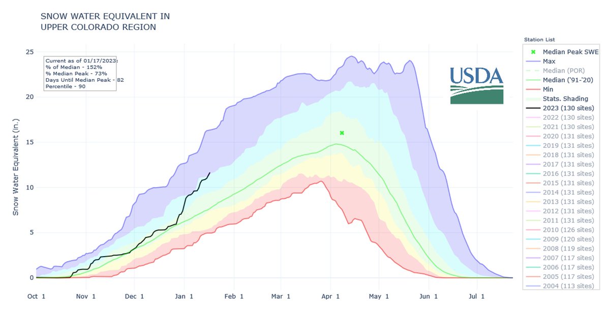
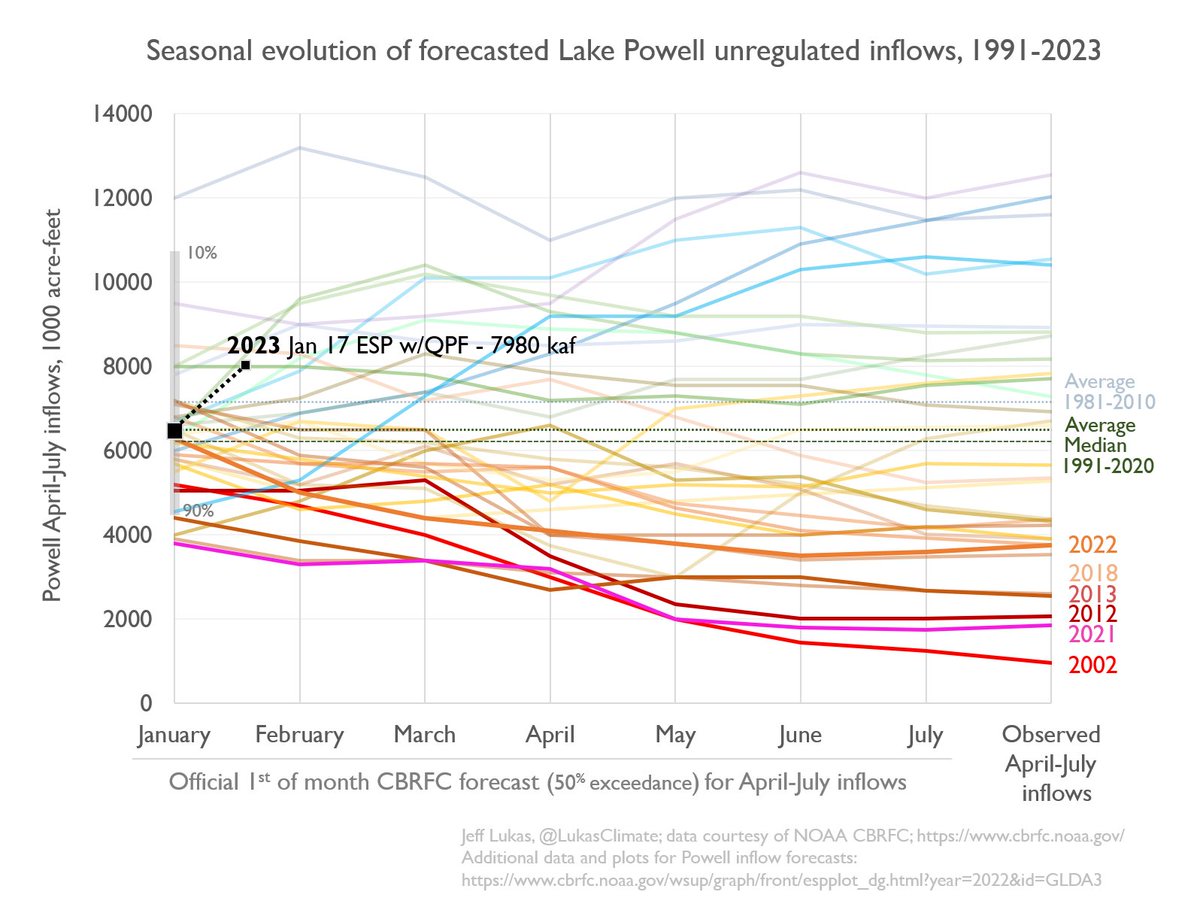
Upper Basin now at >150% of the median SWE for mid-January, and almost 75% of the peak SWE–about three months ahead of the typical peak.

Upper Basin now at >150% of the median SWE for mid-January, and almost 75% of the peak SWE–about three months ahead of the typical peak.
Click the link to read the article on the Denver Water website (Jay Adams):
When it comes to supplying water to 1.5 million people, the spring runoff is the most important time of the year for Denver Water.
That’s why having good information about the snowpack is critical. Mountain snow is Denver Water’s primary source of water for its customers.
When the snow that piles up in the mountains over the winter starts to melt, the water flows into rivers and streams that fill storage reservoirs. The spring runoff typically starts at the end of April and wraps up in late June or early July.
But the work to count the snowflakes starts long before that.
“We keep track of the snowpack through measurements on the ground, from the sky and from automated sensors,” said Nathan Elder, water supply manager at Denver Water. “We monitor the snow all winter because it constitutes the majority of our water supply and has major impacts on how we operate.”
In 2022, the snowpack peaked below average in the areas where Denver Water catches the snowmelt. A below-average snowpack affects the amount of water available to capture and store in the spring.

“We would like to completely fill our reservoir system every runoff season,” said Elder. “In the years when we don’t hit that mark, it makes following the utility’s annual summer watering rules even more critical for the Denver metro area.”
Watering two days a week should be enough for most landscapes for most of the summer. (Only water a third day, if needed, during periods of extreme heat or dryness.)
Following the summer watering rules will help keep reservoir levels higher, in case next winter’s snowpack is below average.

The snowpack data, reservoir forecasts and customer water use are some of the key factors used to determine if Denver Water might need to impose additional watering restrictions beyond the regular summer watering rules, which run from May 1 through Oct. 1.
Here’s a closer look at the primary ways Denver Water’s planning team keeps track of Colorado’s snowpack.
Spread the word, forward this story. Did you get this from a friend? Sign up here for Denver Water’s free, weekly TAP email.
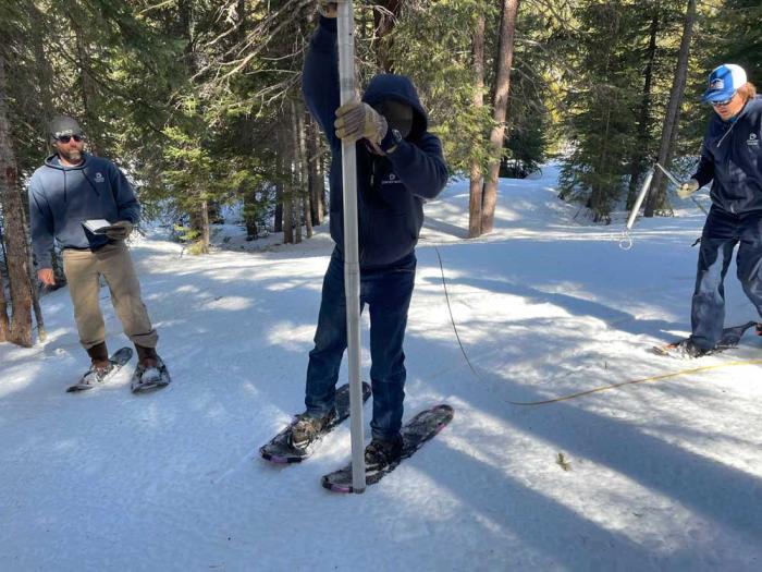
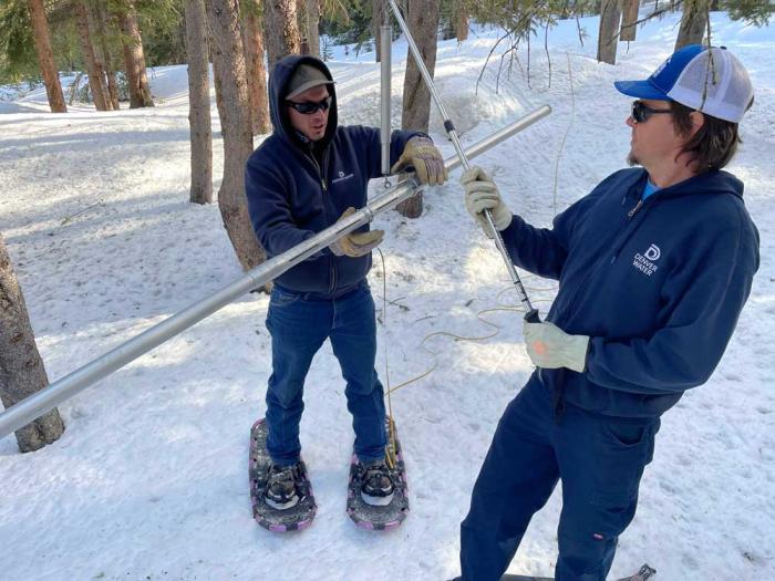
On the ground
Four times a year from January through April, Denver Water crews strap on boots and snowshoes and sometimes ride snowcats to trek into the forest to measure the snow in Grand, Park and Summit counties, the primary areas where the utility collects its water supply for customers in metro Denver.
Each journey follows a specific, predetermined route called a snow course.
Each snow course has 10 designated stops where workers jab a hollow tube into the snow to capture and weigh a sample of the snowpack.
At each stop, the crew conducts a four-step process:
- Collect a sample by dropping the pole into the snow until it hits the ground.
- Measure the depth of snow in the tube.
- Get the weight of the snow by weighing the snow-filled tube and subtracting the weight of the empty tube.
- Calculate the density of the snow using the depth and weight measurements.
Using these measurements, crews calculate the snow water equivalent, or SWE, to determine the water content.
For example, if 10 inches of snow has a density of 10%, the snow water equivalent — the amount of water left behind if those 10 inches of snow melted — is 1 inch of water.
Denver Water shares the data collected on each snow course with the National Resources Conservation Service, or NRCS. Denver Water is one of 15 agencies that sends people out to collect snow data at 95 locations across Colorado in partnership with the NRCS.
The information helps the agency develop water supply forecasts and monitor snowpack trends over time.
The NRCS’s forecasts are used by water provides, dam operators, farmers, ranchers, recreationists and communities to make important decisions about their water supply.
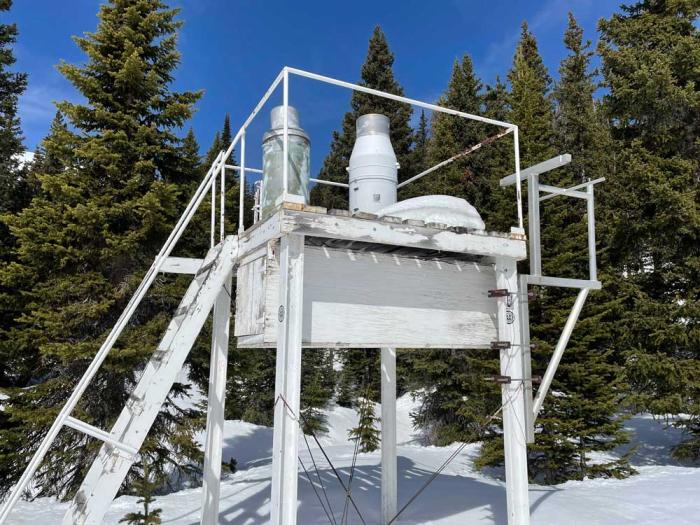
Silent sentries
Along with data collected by hand, Denver Water uses information from snow telemetry sites, or SNOTEL, sites during the winter.
SNOTELs, basically automated backcountry weather stations, were first installed in the 1970s and are operated by the NRCS. The federal agency currently has more than 900 SNOTEL sites collecting data in remote, high-elevation mountain watersheds across the western U.S.
At each site, a bladder about the size of a queen-sized waterbed and filled with antifreeze monitors and reports the weight of the snow falling on it, providing information about the water content frozen in the snow. SNOTEL sites send data multiple times per day, although some sensors report hourly.
Denver Water uses information from 13 SNOTELs located in its 4,000 square miles of watershed.
From the air
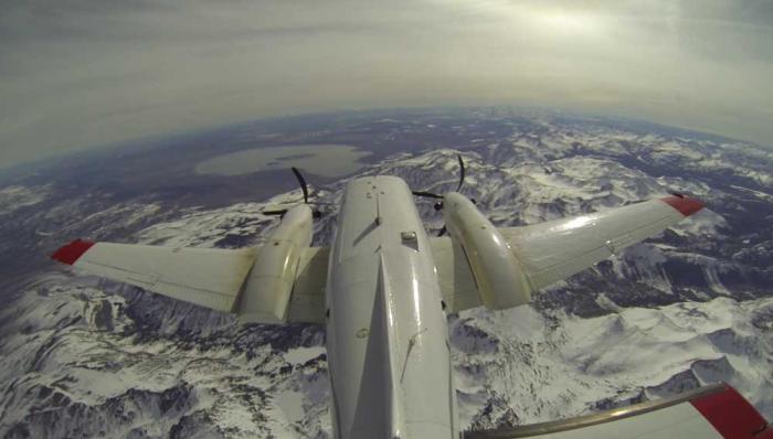
Starting in 2019, Denver Water began getting data about the snowpack from the air, using Airborne Snow Observatory planes stuffed with high-tech equipment flying over the snow-covered mountains.
The plane uses beams of light to measure the depth of the snow fields below and capture reflections from the frozen surface. The equipment pings the snow’s surface at up to 10 locations every square meter, and powerful computers crunch reams of data.
The flights provide an assessment of the amount of water frozen in place in the snow across hundreds of square miles that is more accurate than anything Denver Water has ever had before.
“The data we get from the Airborne Snow Observatory flights quantifies all of the snowpack in river basin below, rather than trying to build a picture of the snowpack in basin using just a few selected point measurements we get from the SNOTELs and the snow courses,” said Nathan Elder, Denver Water’s manager of water supply. “Imagine trying to watch a high-definition TV that only has 10 of its thousands of pixels working; you just don’t get the whole picture.”
And in the face of increasingly variable weather patterns related to climate change, having better information and more accurate forecasts of the seasonal runoff will be more important in the future, he said.
Putting it all together
Elder’s planning team uses data from the snow-measuring methods and combines it with other data such as soil conditions and weather forecasts to determine how much water the winter snowpack will send into Denver Water’s reservoirs.
“Having people hike into the forests to measure the snow by hand is very important for water planners because they give us the ‘boots-on-the-ground’ information we use to verify the data we get from the machines in the SNOTELs and the Airborne Snow Observatory flights,” Elder said.
The forecasts — in turn — help determine how Denver Water will manage the water stored in its reservoirs to meet customer demands in the city and determine if additional water restrictions are needed.
The water supply forecasts are also used to provide information to communities, businesses and other water managers about flooding concerns, water levels for boating on reservoirs, maximizing water rights and how to manage water supplies to benefit the environment.
“Managing water is a very complex business,” Elder said. “The more information and data we can get, the better decisions we can make.”

Click the link to read the article on The Denver Post website (Nick Caltrain). Here’s an excerpt:
Colorado’s attorney general is seeking to reinforce his office’s water-focused legal team so it could be prepared for upcoming fights over the Colorado River. Attorney General Phil Weiser, who was just re-elected to a second term, said his office needs to be prepared for litigation or negotiation with other stakeholders to defend Colorado’s water rights. He’s not asking for an overhaul of the office — his ask to the Joint Budget Committee is for two new positions, and water and natural resources make up an overall small percentage of his office’s total budget — but he noted that “the challenges with water are heating up.”
“The era of the lower basin states taking as much water as they wanted — up to 10 million acre-feet when they’re only entitled 7.5 — is over,” Weiser said recently…
Ideas on bolstering the water supply — or at least not drinking too deep from it — vary. Weiser said his focus is on protecting the state’s share. Lawmakers have said water will be a “centerpiece” of this legislative session. House Speaker Julie McCluskie, a Democrat from Dillon, has also singled out lower basin states for overusing their allotment. Weiser noted the strain on the reservoirs and the pressure that puts on water users up and down the river. Navigating the legal rapids will require negotiation or litigation, he said.
“We’ve got to be prepared for either way,” Weiser told reporters after his investiture ceremony Thursday. “We are not going to be afraid to litigate and protect our rights, and as we can find collaborative solutions, we’ll work hard to do that.”
[…]
If lawmakers approve the request this spring for more water specialists, it would bring the department’s total staff working on interstate water issues to 11, including eight attorneys, according to budget documents. The internal team has already won legal victories against other states and the federal government, as well as saved the state money on outside experts, according to the proposal.
Click the link to read the article on the Inside Climate News website ( Bob Berwyn and Katie Surma):
Forests managed by Indigenous peoples and other local communities in the Amazon region draw vast amounts of planet-warming carbon dioxide out of the atmosphere while the rest of the rainforest has become a net source of the greenhouse gas, a new report has found.
The discrepancy results from differences in deforestation rates between the two types of land.
The study from the World Resources Institute, a nonprofit global research organization focused on solving environmental challenges, adds to a growing body of evidence showing that land held by Native peoples and other local communities around the world has better environmental outcomes than government and privately owned land.
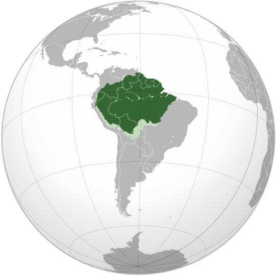
The WRI study, published on Jan. 6, marks the first time researchers have quantified the forest carbon benefits of Indigenous territories and land stewarded by local communities in the Amazon region, which spans Bolivia, Brazil, Colombia, Ecuador, French Guiana, Guyana, Peru, Suriname and Venezuela.
From 2001 to 2021, forested areas in the Amazon managed by Indigenous communities removed about 340 million more metric tons of carbon from the air each year than they emitted, an amount equivalent to the annual carbon emissions of the states of California and Massachusetts combined. Land managed by other local communities had similar outcomes, researchers found.
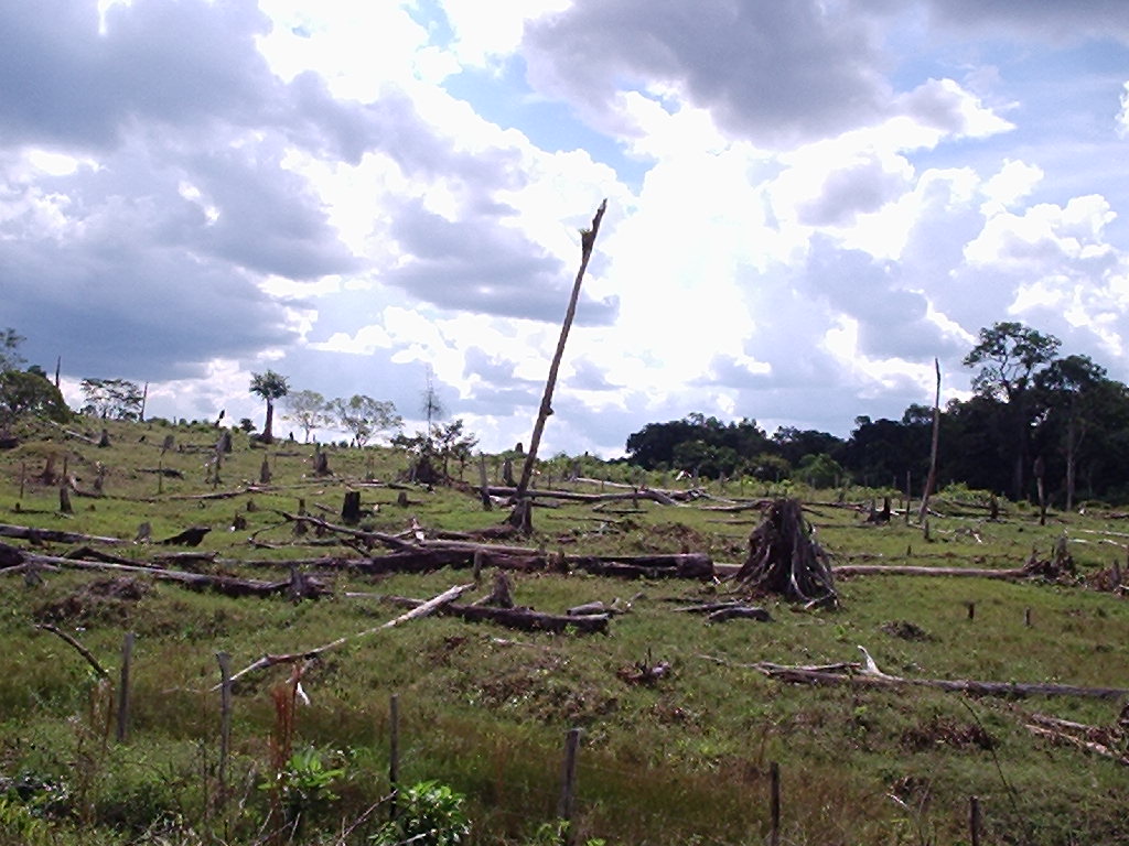
All other forested land in the Amazon region was a net source of carbon over the same time period because of high rates of forest loss.
While the main contributors to planetary warming are greenhouse gases released from the burning of fossil fuels, forests can also become a source of carbon dioxide emissions. Trees store carbon dioxide within their leaves, branches, trunks and roots. When they are destroyed through fires or clear-cutting, once-sequestered carbon is released into the atmosphere. In the Amazon region, drivers of deforestation include development from industrial agriculture, cattle ranches, mining, oil extraction and other activities, both legal and illegal.
The WRI report’s findings add an exclamation point to the evidence that Indigenous peoples and local communities are a major force in preserving the Amazon rainforest amid the rapid deforestation on land held privately or by governments.
According to Peter Veit, a co-author of the report and the director of WRI’s Land and Resource Rights Initiative, about 17 to 18 percent of the Amazon has been deforested in the last 50 years. Scientists estimate that once those levels get to 20 to 25 percent, the rainforest will hit an irreversible tipping point from which the region will transform into grasslands and savannah. The change would result in the release of an estimated 123 billion tons of carbon into the atmosphere, kill off thousands of plant and animal species and wipe out hundreds of distinct human cultures tied to the rainforest.
“We are very close to that tipping point,” Veit said.
The WRI report comes as land not just in the Amazon region but throughout the world is under increasing pressure for food production, resource extraction and other demands linked to human population growth.
About half of Earth’s land is stewarded by Indigenous and other local communities. Many of those groups have insecure land tenure, making them vulnerable to land theft, appropriation and related violence. Each year, about 200 land defenders, including many Indigenous people, are killed, although that estimate is widely considered an undercount.
Veit suggests that governments can support Indigenous and local communities in protecting their territories by integrating their efforts into national climate plans, giving them secure title to their land and increasing direct funding to those communities.
“We’re showing one of many reasons that forests controlled by Indigenous peoples should be valued,” said David Gibbs, a researcher at Global Forest Watch and a co-author of the report. The research, he said, “adds to the list of reasons that we already have to help protect those communities.”
The Benefits of Local and Indigenous Control
In general, Indigenous peoples and local communities manage their land in a sustainable way based on customs and cultural values that are intertwined with the forest.
“For Indigenous people and other communities, their land is a primary source of food, medicine, fuelwood and construction materials, as well as employment, income, welfare, security, culture and spirituality,” the report notes.
That interdependence with intact forests creates an incentive for communities to sustainably manage their lands, Veit says.
If left alone, most of those communities would continue to live as they have for hundreds of years. But they are increasingly under threat from outside pressures like legal and illegal mining, logging and agriculture, he said.
While all forest in the Amazon region both stores and emits carbon, Indigenous lands capture more carbon than they emit each year when the entirety of that flux is considered. Veit and Gibbs said their analysis identified which Indigenous territories have higher carbon emissions and found that those communities may face greater pressures from resource extraction.
In Brazil, home to the greatest portion of the Amazon rainforest, the Indigenous communities in forests with the greatest carbon emissions are located in the country’s southeast, an area known as the “arc of deforestation.” In Peru, Indigenous lands that were net sources of carbon were located in regions dominated by gold mining.
Of all the ways that governments can help communities defend their forestland from incursions that could increase the carbon emissions, Veit said that providing them with secure land title is the most important.
In Brazil, the demarcation and formal titling of Indigenous peoples’ land stopped under former President Jair Bolsonaro’s administration, which held power from 2019 to 2022. Bolsonaro also defunded governmental agencies tasked with enforcing the rights of Indigenous peoples. Over the course of his presidency, deforestation rates in the country surged.
While obtaining legal title to land is important, the type of legal title communities obtain also makes a difference in their ability to defend their land from incursions by resource extraction and agricultural interests.
In most Amazonian countries, national governments reserve ownership of material that lies below the surface of the land, making it easier for them to grant companies licenses for mining and other extractive activities.
“When you get security of land, you don’t get security like we do in the United States of all subsurface rights,” Veit said. “Your rights in the Amazon extend 10 inches below the surface and that’s it.”
Veit has done research comparing the legal authority granted to extractive companies through means such as mining concessions with the legal rights given to landowners like Indigenous communities.
“They don’t compare,” he said. “The natural resource rights holders have tremendous power to go onto and use land.” Human rights experts have advocated for communities’ gaining greater control over their territories and a right of refusal when governments and businesses seek to engage in resource extraction on or near their land.
“Many governments around the world still view themselves as the best holders of common property rights to resources,” Veit said. “It’s ridiculous. There’s a real mistrust that communities can manage these important resources despite the evidence that shows that they can.”
Amazon Emissions in Flux
The WRI report is based in part on a 2021 study in the journal Nature Climate Change that offers one of the best estimates of how much carbon dioxide was emitted by forests and how much they removed from the atmosphere globally in the last 20 years. The paper concluded that, during the 2001 to 2019 study period, forests sequestered about twice as much as they emitted each year—storing about 7.6 billion metric tons per year, or 1.5 times more than the United States emits annually.
The Amazon is a big part of that global equation, but the international team of authors acknowledged in their opening paragraphs how challenging the measurements are at global and regional scales. Emissions and absorption can take place simultaneously within regions, depending on when and where the forests are disturbed and managed, they wrote.
The carbon fluxes, as scientists call them, also have high seasonal variability, and it’s not easy to distinguish between natural fluctuations and those caused by disturbances like fires and logging. All of that makes it hard to reproduce them in global climate models, although measuring them accurately is “increasingly important for climate policy,” the paper noted.
The scientists found that during the study period, forests in the Brazilian Amazon were a net source of .22 gigatons of carbon dioxide emissions per year but that the forests spanning all nine countries of the greater Amazon River basin (526 million hectares) were a net carbon sink, taking up .10 gigatons of carbon dioxide. By contrast, they noted, the net sink in forests of Africa’s Congo River basin (298 million hectares) was approximately six times stronger than in the Amazon basin.
The main reason is the far lower rate of human disturbance in the Congo River forests, Gibbs said.

Click the link to read the article on the Big Pivots website (Allen Best):
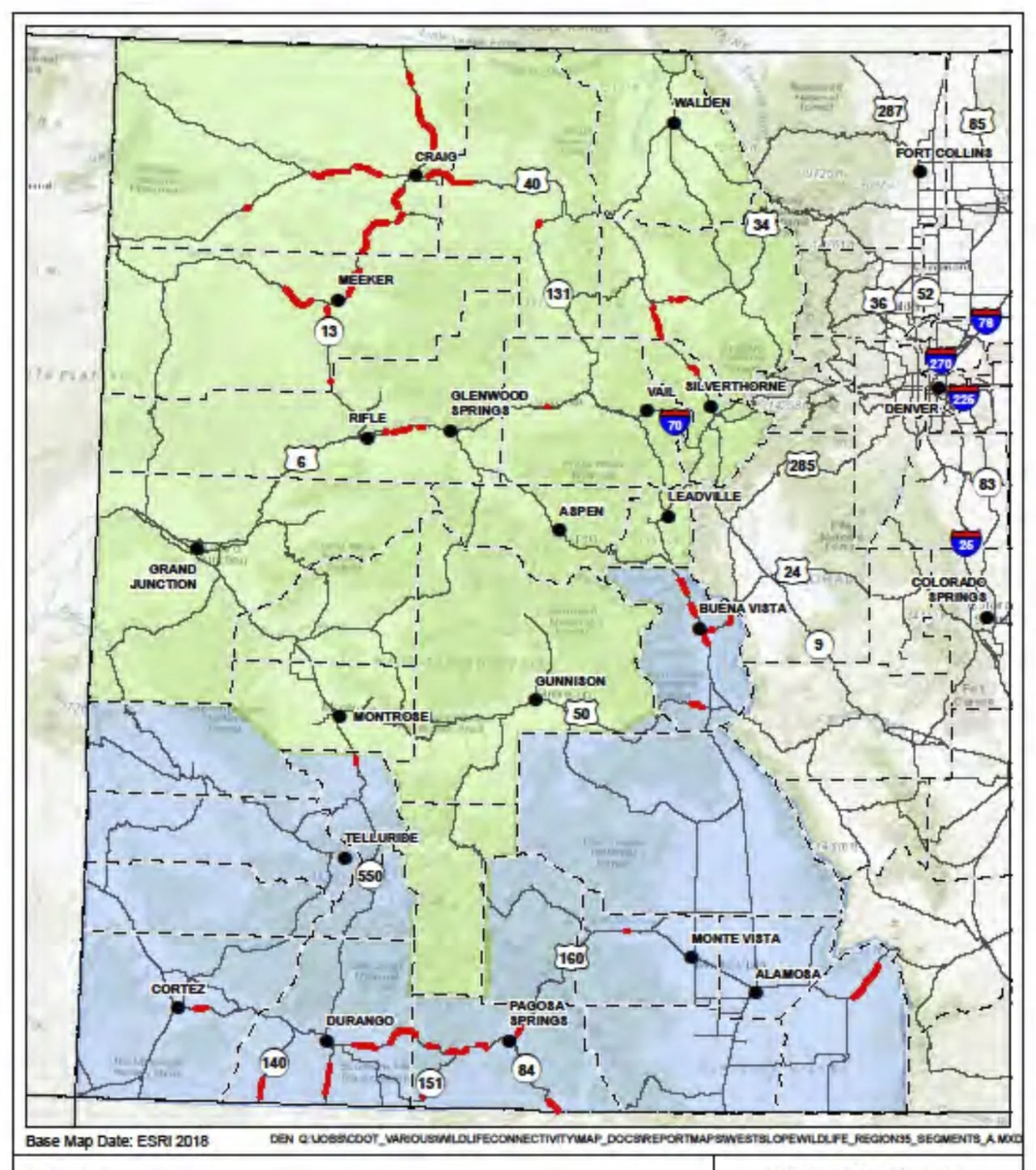
$5 million in projects an important step in reimagining Colorado’s highways to accommodate wildlife
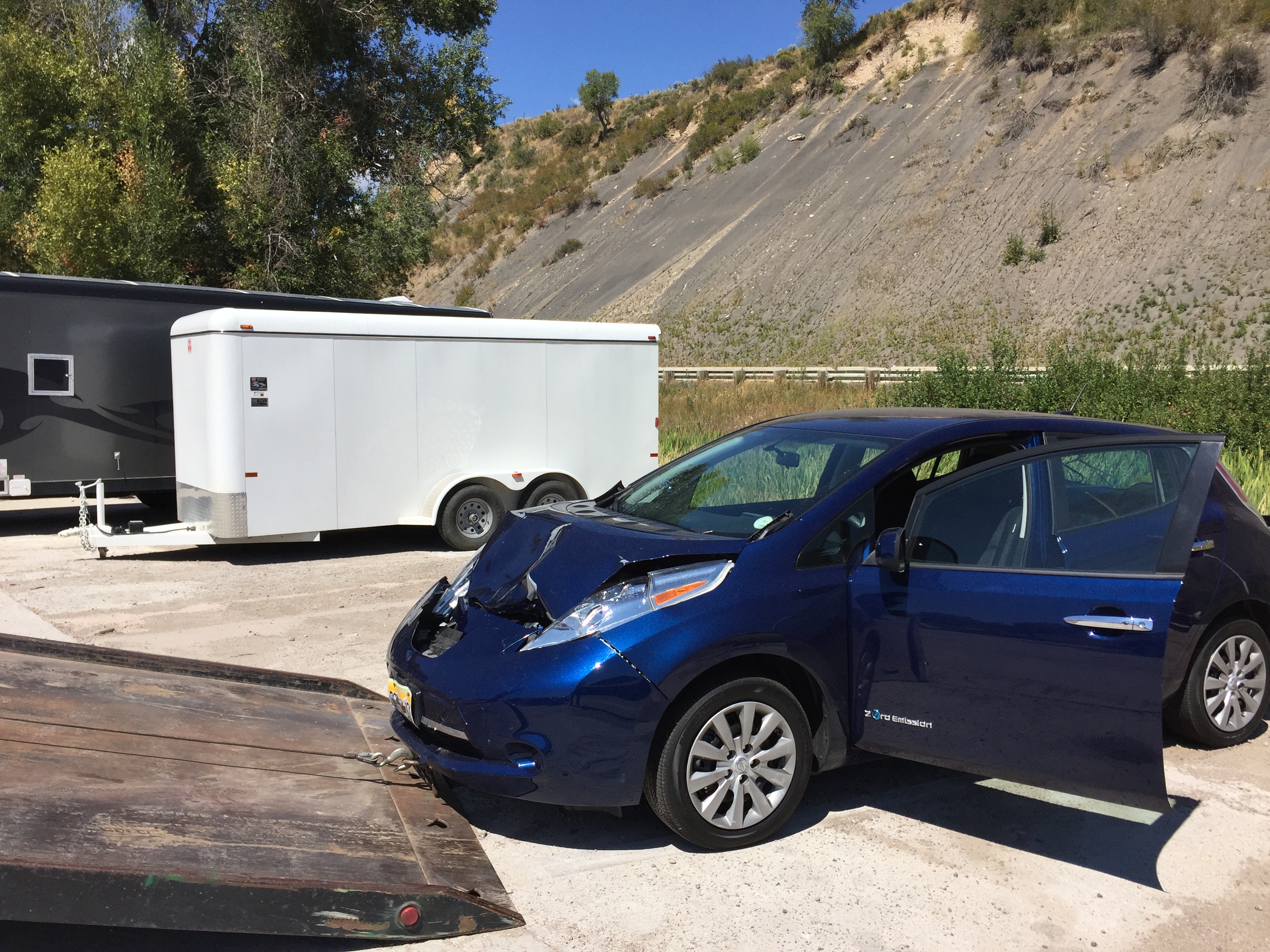
Although never a big-game hunter, I have killed three deer in Colorado and likely gave a bull elk a terrific headache. That’s not to mention my carnage among rabbits and other smaller critters.
Cars were my weapon, not guns.
Driving at dusk or into the darkened night will inevitably produce close brushes with wildlife, large and small, on many roads and highways. Even daylight has its dangers.
Colorado is now redefining that risky, ragged edge between wildlife habitat and the high-speed travel that we take for granted. State legislators delivered a message last year when appropriating $5 million for wildlife connectivity involving highways in high-priority areas.
In late December, state agencies identified seven locations where that money will be spent. They range from Interstate 25 south of Colorado Springs to Highway 13 north of Craig near where it enters Wyoming. New fencing and radar technology will be installed. Highway 550 north of Ridgway will get an underpass.
The pot wasn’t deep enough to produce overpasses such as two that cross Highway 9 between Silverthorne and Kremmling or one between Pagosa Springs and Durango. But $750,000 as allocated to design work for crossings of I-25 near Raton Pass with a like amount for design of an I-70 crossing near Vail Pass.
In this and other ways, Colorado can better vie for a slice of the $350 million allocated by Congress in the 2021 Infrastructure Investment and Jobs Act for improved wildlife connectivity.
This is on top of the overpass of I-25 planned for the segment between Castle Rock and Monument to complement the four underpasses installed in the widening project of recent years.
We are pivoting in how we regard roads and wildlife habitat. We have long been driven to protect human lives and our property by reducing collisions. Our perspectives have broadened. Human safety still matters, but so do the lives of critters.
Before, says Tony Cady, a planning and environmental manager for the Colorado Department of Transportation, highway safety for people was the highest priority —and conservation for wildlife a distant second. “Now we’re seeing much more of a wedding or marriage of those tow values, safety and conservation.”
Biologists in the 1990s began emphasizing highways as home wreckers. Expanding road networks, they said, was creating islands of wildlife habitat. Fragmented habitat leads to reduced gene pools and, at the extreme, to the threat of extinction of species in some areas, called extirpation.
I-70 became the marquee for this. Wildlife biologists began calling it the “Berlin Wall to Wildlife.” The aptness of that phrase was vividly illustrated in 1999 when a transplanted lynx released just months before tried to cross I-70 near Vail Pass. It was smacked dead.
With that graphic image in mind, wildlife biologists held an international competition in 2011 involving I-70. The goal, at least partially realized, was to discover less costly materials and designs.
Colorado’s pace has quickened since a 2014 study documenting the decline of Western Slope mule deer populations. Also helpful was creation of the Colorado Wildlife and Transportation Alliance, a consortium of the state’s transportation and wildlife agencies along with federal land agencies and non-profit wildlife groups.
In 2019 an incoming Gov. Polis issued an executive order to state agencies directing them to work together to solve road ecology problems.
Two wildlife overpasses along with underpasses and fencing north of Silverthorne completed in 2017 have been valuable examples. Studies showed a 90% reduction in collisions.
“An 80% to 90% reduction right off the bat is pretty typical for these structures,” says Cady
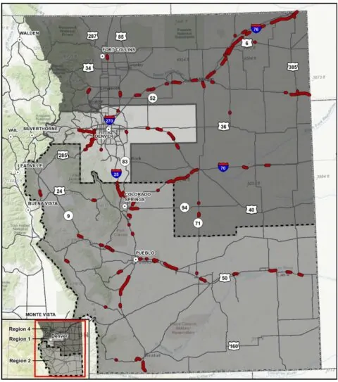
Beginning in 2016 for the western half of the state, data have been crunched to delineate the state’s 5% highest priority road segments. These data may give Colorado a leg up on access to federal funds.
The two studies found 48 high-priority segments in western Colorado and 90 in eastern Colorado, reports Michelle Cowardin, a wildlife biologist for Colorado Parks and Wildlife. The Craig and Meeker areas have lots of high priority roads, but so is much of I-76 between Fort Morgan to Julesburg.
Some jurisdictions are diving deeper. Eagle County has completed a study of wildlife connectivity, and Pitkin County has secured funding for a first-step study that will identify highest-priority locations in the Roaring Fork and Crystal River valleys.
These new studies attest to a shift in public attitudes and a shift within the state agencies. Cady says that highway engineers still think about human safety first, but there has also been a shift.
“I think the mindset has shifted in the last four or five years. We are not having to justify the inclusion of wildlife components in projects. It’s more understood that these are necessary components.”
To be clear, remediation in Colorado is mostly done as part of road projects. The work on Highway 160 between Pagosa and Durango, for example, came in at $11 million, of which only $3.5 million went to the overpass and also an underpass as well as other measures with wildlife in mind.
Projects also tend to have multiple funding sources. For example, the Southern Ute Tribe provided $1.5 million for that project near Pagosa. The project on Highway 9 in Middle Park included $4 million from a local rancher.
Rob Ament of Montana State University’s Western Transportation Institute says wildlife connectivity is becoming institutionalized in how we think about transportation corridors. Instead of motivated solely to minimize risk to humans, there’s growing appreciation of the needs of wildlife, too.
There’s solely motivation an extravagance, he says, crossings are becoming a cost of doing business.
This is happening internationally, too. “My world is just exploding,” he said while reciting crossings for elephants in Bangladesh, tigers in Thailand and work for other species in Argentina, Nepal, and Mongolia.
From email from Reclamation (Erik Knight):
The next Aspinall Operations meeting is scheduled for this Thursday, January 19th, start time 1:00pm
The meeting will be open to in-person attendance at the Western Colorado Area Office in Grand Junction.
445 West Gunnison Ave
Grand Junction, CO
The meeting will also be available to attend virtually via Microsoft Teams. Please click on this link to attend the meeting virtually.
This link should open in any smartphone, tablet, or computer browser, and does not require a Microsoft account.
The meeting agenda with handouts will be emailed out prior to the meeting.
For any questions please email or call at the number below.
Erik Knight
970-248-0629
WCAO-GJ
Long way to go, but really low Colorado River flows are off the table.