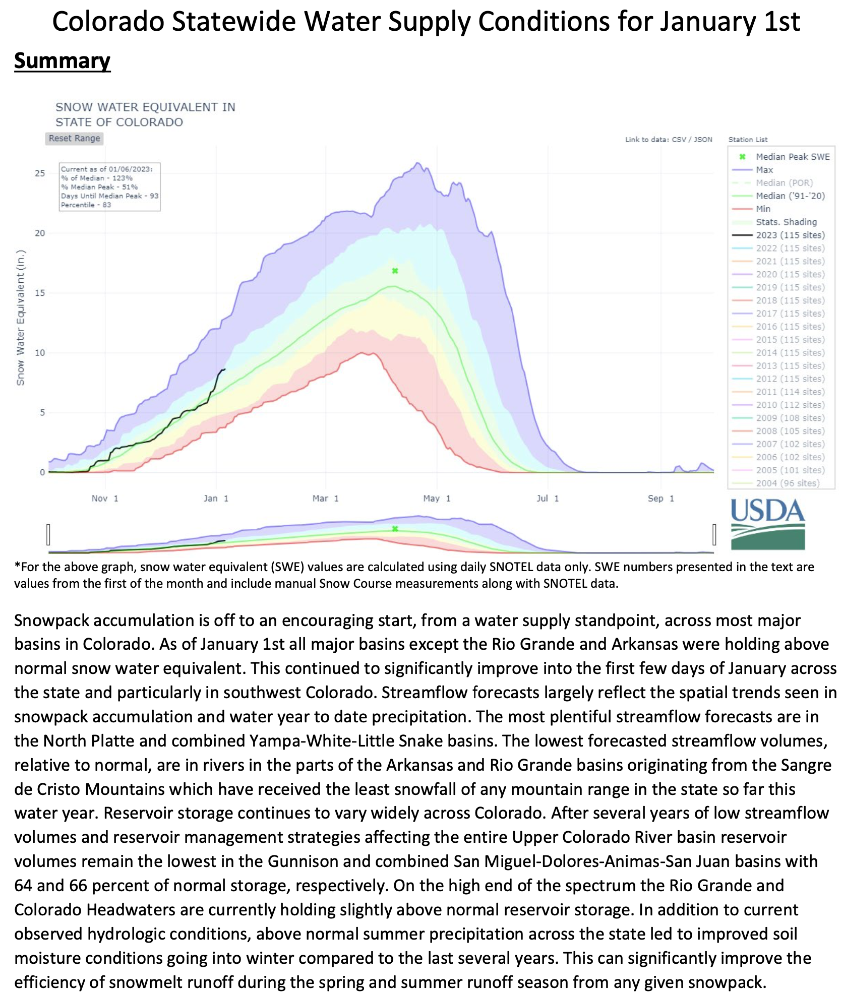
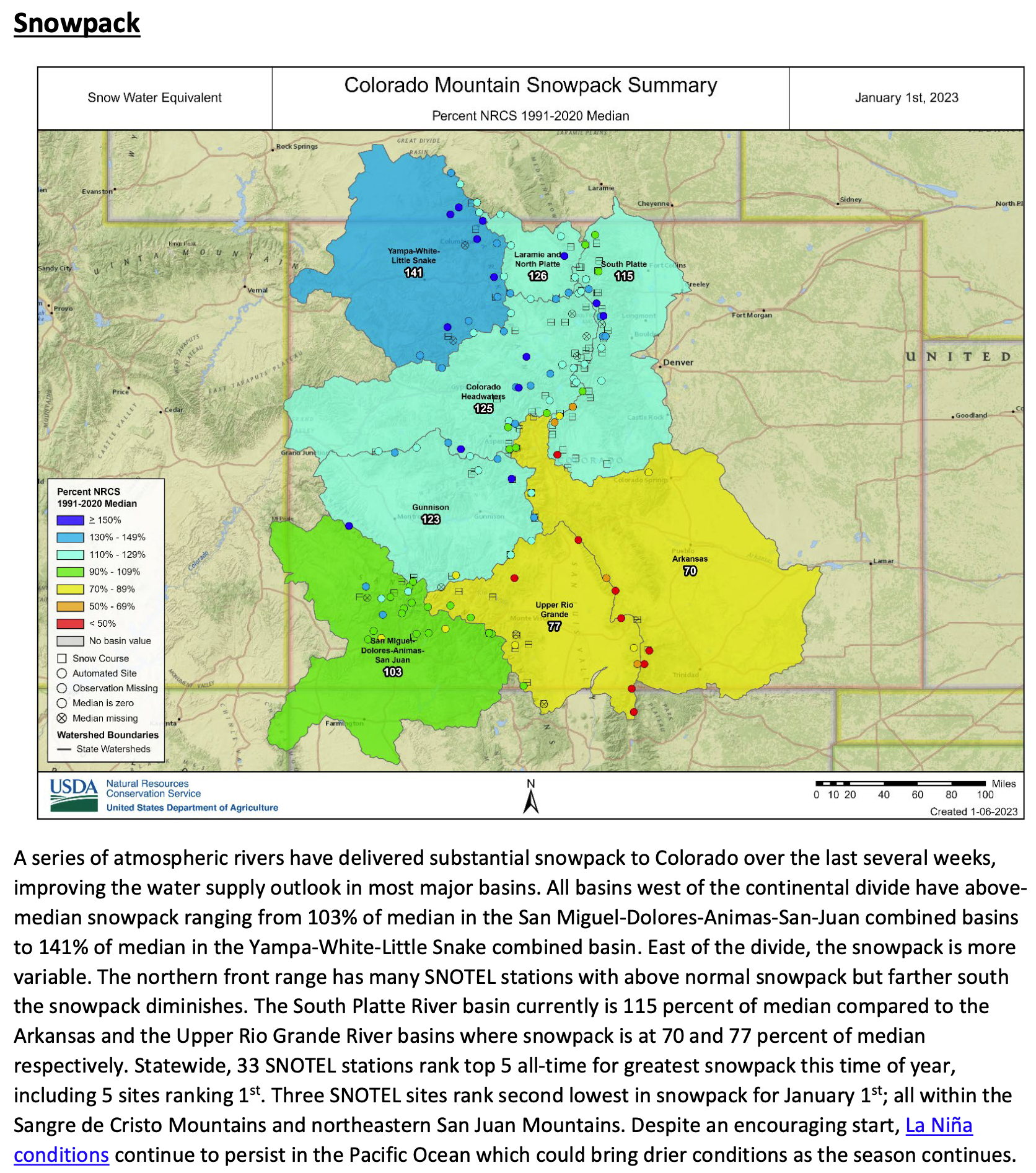
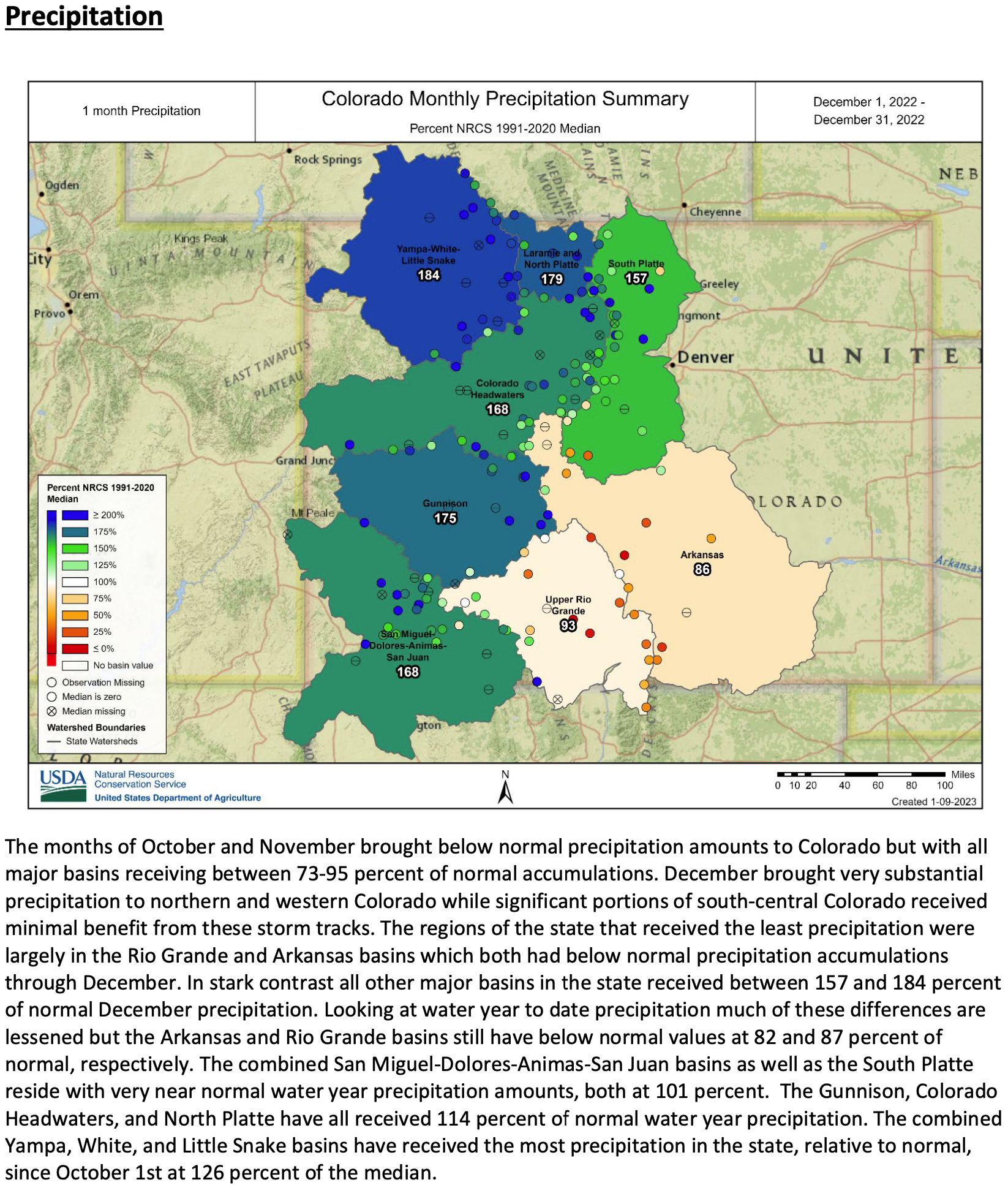
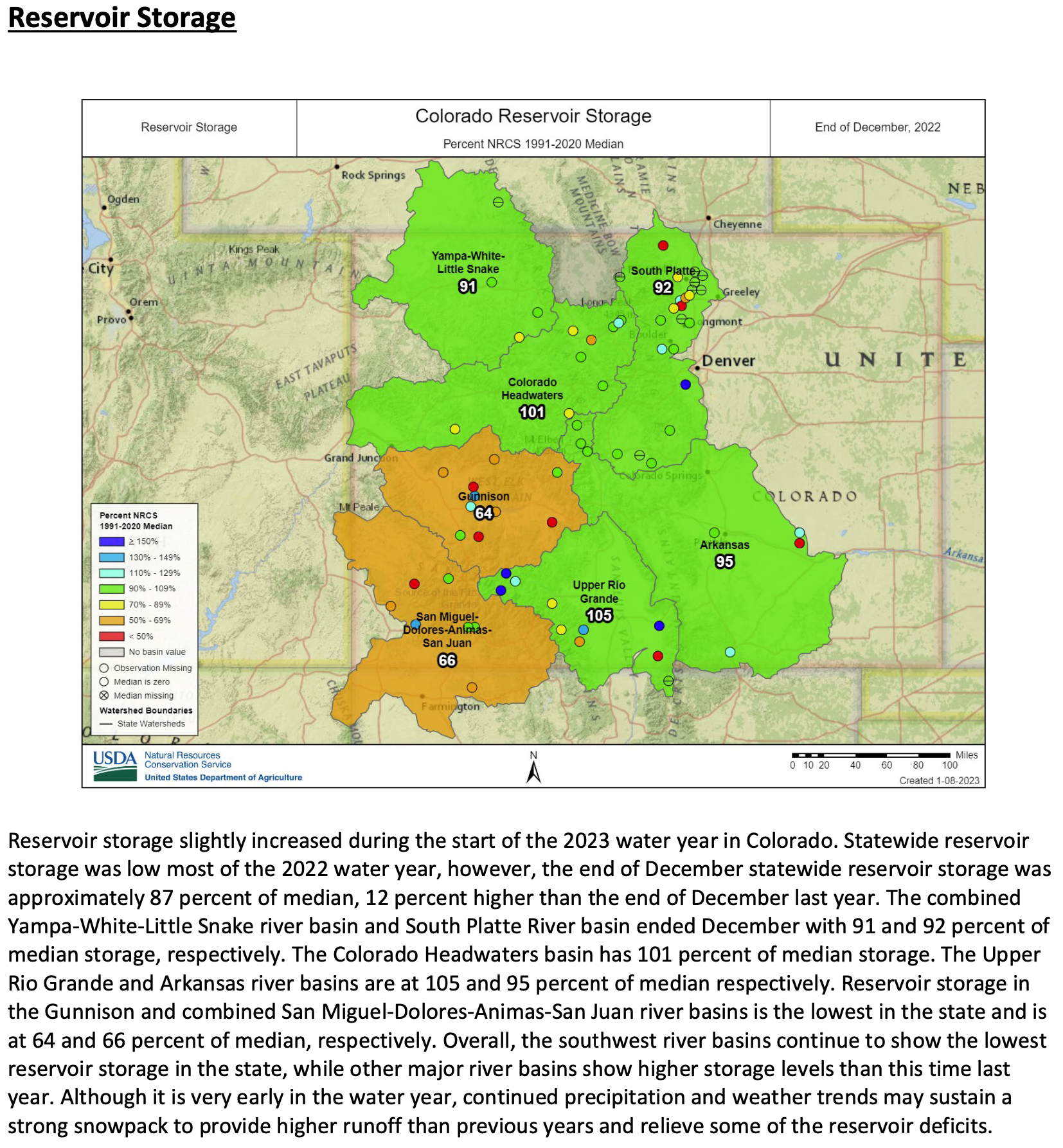
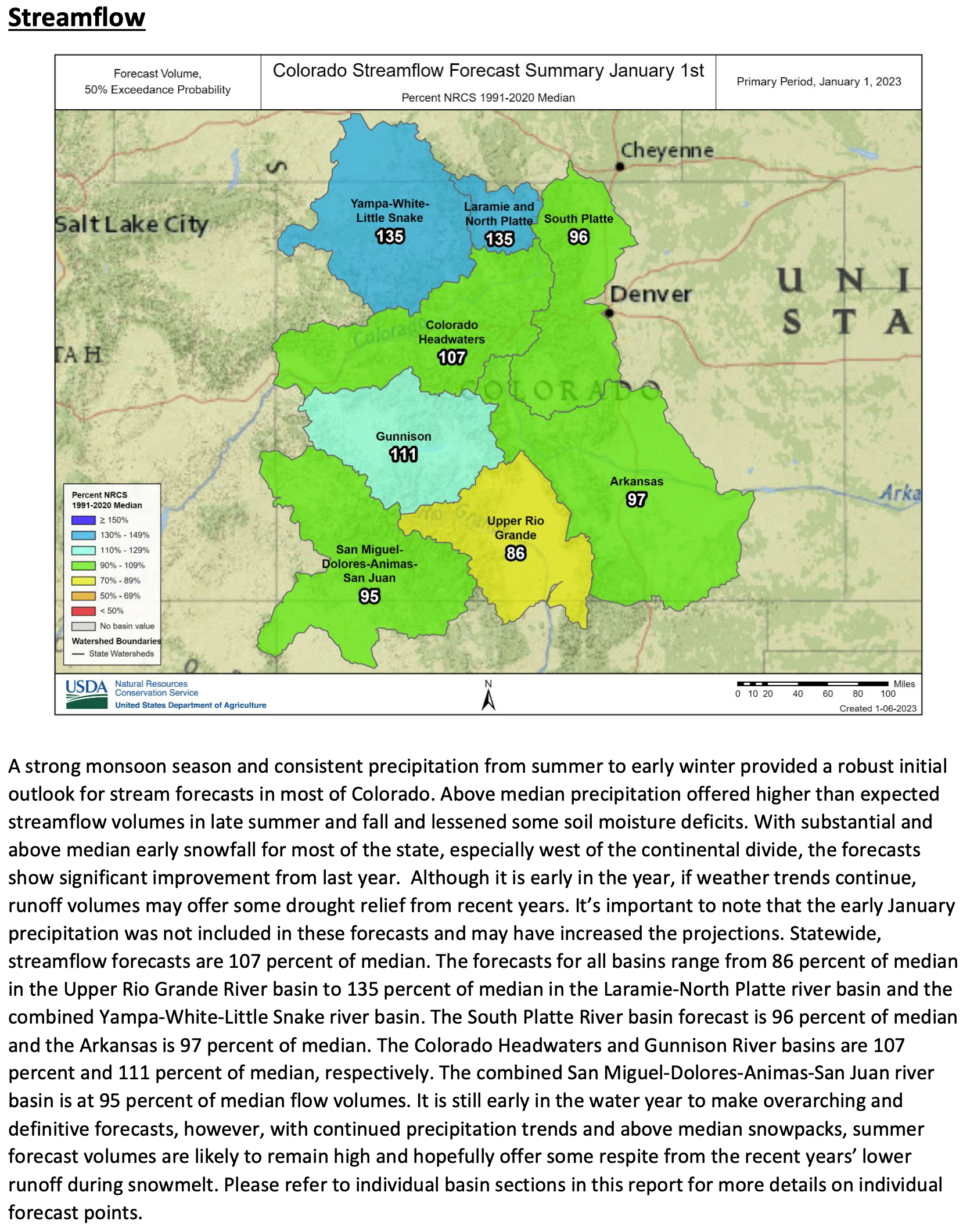
Click here to access the report on the NRCS website.

Click the link to read the guest essay on The New York Times website (Erica Gies). Here’s an excerpt:
Ms. Gies is the author of “Water Always Wins: Thriving in an Age of Drought and Deluge.”
The big hope is that an array of paleo valleys could be turned into giant storm drains to quickly absorb heavy rain. Storm water spread over the valleys would sink underground and then move into the surrounding clays and silts, for more than 12 miles on either side of the valley and for hundreds of feet in depth, according to one study. It would raise the diminished water table, which is important because a healthier underground water system can feed rivers from below and allow people to continue to pump water from wells. It can also make more water available to plants and soil, help to sustain the rain cycle and reduce fire risk.
There is enough unmanaged surface water from rain and snow statewide to resupply Central Valley aquifers, making more water available to farmers, urban dwellers and the environment. Even with climate change, the state will most likely have enough water for recharge in the future in part because of more extreme weather, according to a 2021 study.
To use paleo valleys to store these big rains, the land above them must be conserved for groundwater recharge. And that’s already a challenge: One paleo valley found outside of Sacramento has been slated for housing developments, which would cover it with impermeable concrete and asphalt. Such decisions are typically governed by city and county governments, but the state could incentivize areas with paleo valleys to protect the land above them.
Land use isn’t the only issue. The state’s major aqueducts that move water from north to south can also play a big role in helping floodwater reach the paleo valleys. The aqueducts are underused in winter when fewer growers need to irrigate their crops and could transport excess storm water to depleted aquifers. Pipes could be added to them to move the water to the paleo valleys…
Erica Gies is a National Geographic explorer and journalist. She is the author of “Water Always Wins: Thriving in an Age of Drought and Deluge.”Erica Gies is a National Geographic explorer and journalist. She is the author of “Water Always Wins: Thriving in an Age of Drought and Deluge.”
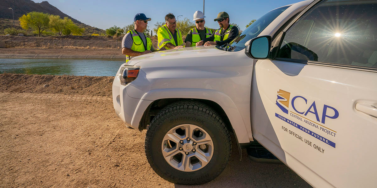
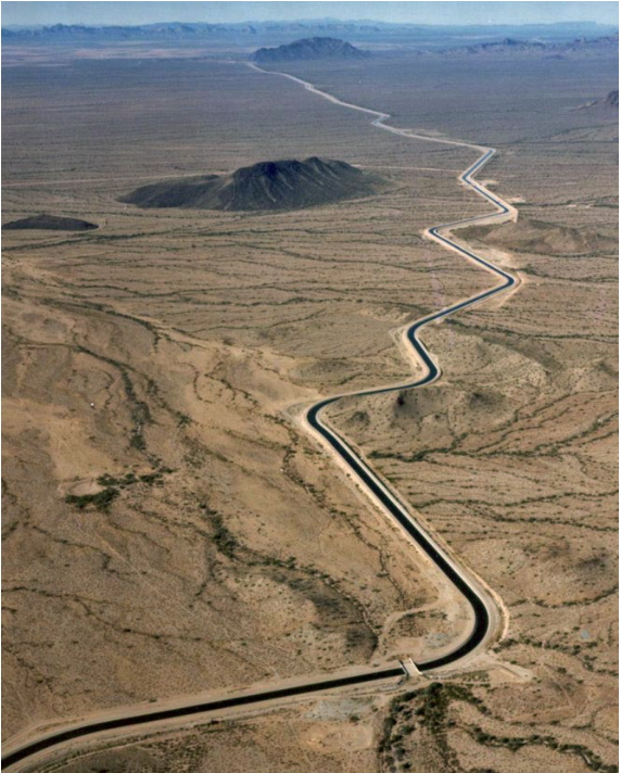
Click the link to read the post on the Central Arizona Project website (Nick Walter):
Like athletes trained for gameday, practice often proceeds a live scenario. Central Arizona Project (CAP) employees charged with delivering water to central and southern Arizona aren’t necessarily developing curveballs or running sprints, but the process to “keep the water flowing” is similar: prepare through realistic repetition.
In the event of a rare disaster, the ability for CAP to remotely control water flow and equipment from its Control Center at CAP headquarters could be partially or completely lost.
What happens then?
CAP would be prepared to maintain uninterrupted water deliveries to CAP water users by operating its masses of system infrastructure that covers much of the state — all by hand.
This past fall and winter, CAP’s manual operations drill was essentially training before any catastrophe.
A statewide system to maintain
The CAP system could be thought of as a water infrastructure backbone of Arizona. Spanning 336 miles from Lake Havasu to Tucson, it includes 14 pumping plants, 39 check gates and more than 50 turnouts.
In normal operations, this complexity includes some 30,000 “data points” that are sent to the Control Center, which is like the brain of the system. CAP operators work 24/7 to remotely monitor and control the system based on real-time data. A data point could be an analogue point that represents the canal water level. Or it could include other data and signals such as the status of equipment, position of a check gate, or speed of water.
The digital points function as the “eyes and ears” of the equipment.
In a worst-case scenario, however, human eyes and ears of CAP employees would operate the system on site.
The backup plan: manual labor
In a manual operations scenario, CAP staff would put boots to the ground to control each piece of equipment and report data points throughout the critical infrastructure that delivers water to more than 80 percent of the state’s population in Maricopa, Pima and Pinal counties.
This could include:
- Plant employees starting and stopping pumps.
- Aqueduct maintenance employees opening, closing, or adjusting check gates and turnouts to maintain correct flow of water.
- Field employees providing critical data such as water levels, flow rates, or unusual conditions to CAP’s dispatch team.
The severity of the outage would dictate the number of CAP employees needed to operate equipment in the field.
Quite possibly, that could include 24-hour coverage.
Fortunately, many fail-safes, or layers of “redundancy”, are already in place to mitigate mishaps during normal operations.
A will to drill
The manual system-operations drills replicate a live, manual operations scenario. They help ensure CAP dispatchers and other necessary personnel are up to date on manual operating procedures, including calculations and timing.
One example: confirming the time it takes for employees to drive to a specific site such as a check gate, make flow adjustments to the equipment, and then travel to the next site. Consideration also must be given to time required for released water to move from one check gate to a siphon, tunnel, or another check gate, as well as the effect of the timeframe on the flow of water.
So before a disaster would occur, CAP ensures its team of dispatchers, aqueduct crews and maintenance teams are trained to hand-operate the CAP.
They may not be athletes in action, but someday, their efforts could keep the water flowing for millions of Arizonans.


Click the link to read the post on the American Rivers blog (Katy Neusteter):
Brian Wong has a lot on his shoulders. A third-generation farmer, Wong grows crops — including nearly extinct heritage grains like white Sonora wheat — on 4,500 acres in the heart of the parched Sonoran Desert, about 25 minutes northwest of Tucson, Arizona. Bakeries, restaurants, breweries, and flour mills as far away as Minnesota and Florida rely on his grain to sustain their own businesses.

Wong’s BKW Farms is among the 80 percent of the state’s agricultural producers that rely on the Colorado River to irrigate their crops. And with the Colorado at precariously low levels, his family business faces its largest challenge in nearly 85 years. “We have a great understanding of and place great importance on water,” Wong says. “Water is something you need in almost every aspect of agriculture. Everything we grow is irrigated. We need to have a water source to put on the crops so we can continue growing food.”
All of the water irrigating Wong’s farm arrives via the Central Arizona Project (CAP), a 336-mile canal system that shuttles Colorado River water to customers throughout the state. Altogether, the Colorado irrigates 5 million acres of farm and ranch land across seven Southwestern states and Mexico. It supplies 40 million people with drinking water and supports a $1.4 trillion economy.
But climate change, extreme drought, and explosive population growth are taking an enormous toll on the river. The Colorado and its two largest reservoirs, Lake Powell and Lake Mead, dwindled to calamitously low levels in 2022, forcing the U.S. Department of the Interior to declare, for the first time in history, a Tier 1 Water Shortage. The declaration triggered deep cuts in the volume of Colorado River water delivered to Arizona, Nevada, California, and Mexico. Arizona agriculture took the biggest hit because CAP is on par to get 30 percent less water from the shrinking river. Even deeper restrictions will go into effect in 2023, with cities and Tribes shouldering more of the brunt.
Alongside farmers like Wong, American Rivers is urgently working together with partners at utilities, municipalities, and conservation groups to fix the massive imbalance between demand and a shrinking Colorado River.

From working with ranchers to restore habitat in the river’s headwaters, to encouraging municipalities to use less and eliminate unnecessary uses of valuable Colorado River water, to working on new guidelines for long-term management of the river, American Rivers is involved in decisions that span 1,700 miles of the Colorado River, from its headwaters in Colorado to its delta in Mexico.
“The hard truth is, there just isn’t enough water to go around for everyone,” Wong says.
We have to learn to live with a smaller Colorado River. Wong says the way forward is by partnering with advocates like American Rivers, who work with policymakers and stakeholders to elevate stories and shape water-management strategies into the future.
The bottom line is that “I” doesn’t work. We all rely on rivers, and water, and their continued existence. Our future demands that we invest boldly and immediately in strategies that will work — and that will build for all of us the kind of future we want for our children.
Click the link to read the article on the EOS website (Krystyna Powell, Safra Altman and James Marshall Shepherd):
Natural and engineered nature-based structures offer promise for storm-related disaster risk reduction and flood mitigation, as long as researchers can adequately monitor and study them.
The 2020 and 2021 Atlantic tropical storm seasons were extremely busy, ranking as the first and third most active on record, respectively. Thirty named storms occurred in 2020 alone, with 11 making landfall in the United States (a record) and 13 making landfall elsewhere (also a record) around the Caribbean, the Gulf of Mexico, and even Portugal (a first). The 2021 Atlantic season produced another 21 named storms. The 2022 season, which ended officially on 30 November, was closer to average, producing 14 named storms, although several—Hurricane Ian especially—caused extensive damage.
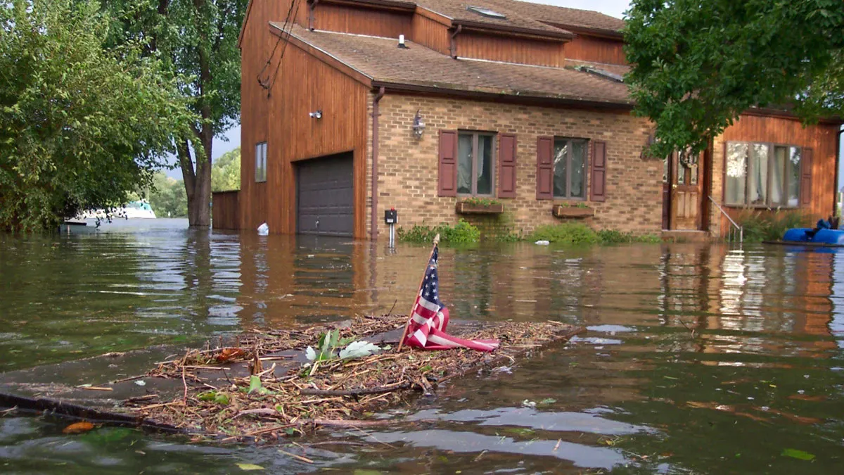
In addition to direct impacts of episodic tropical storms, much of the coastal Atlantic region increasingly has experienced extreme rainfall, storm surges, and even fair-weather inundation exacerbated by sea level rise. Such compound weather-related disasters reveal new and heightened vulnerabilities affecting broad swaths of people, particularly in marginalized and underserved communities.

Protecting coastal communities from the effects (and aftereffects) of repeated pummeling by tropical storms and other disasters requires an all-hands-on-deck approach, with contributions from physical, biological, chemical, and social scientists as well as from engineers, policymakers, and community members. Building this resilience also requires new solutions. [ed. emphasis mine]
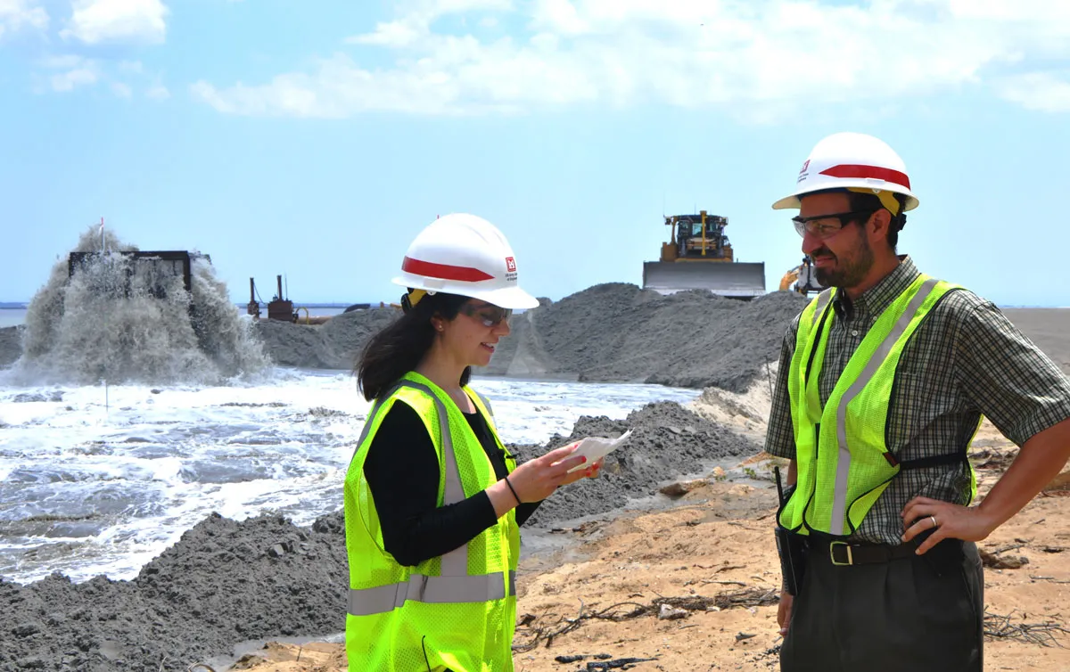
Much of the needed innovation to meet the challenges of natural disasters will come from modern engineering expertise. Yet nature itself provides time-tested examples of resilience and recovery from which we can learn. Natural and nature-based features (NNBFs) can support coastal resilience and mitigate flood risk while providing ecosystem services. Berms and dunes, for instance, are nature-based features that can be engineered or enhanced along coastlines to minimize flooding and storm damage in communities and to achieve ecosystem restoration goals.
Understanding how NNBFs perform under extreme hydrometeorological hazards and in other natural disasters in comparison with traditional infrastructure is critical. This understanding requires thorough monitoring across the life cycles of disaster events, including data on conditions before, during, and after, which allow researchers to evaluate how physically effective and cost-effective NNBF projects are in achieving their intended purposes, whether they involve coastal engineering, sustainable management, wetland restoration, or natural hazard reconnaissance. But collecting these data presents major challenges.
In a 2021 workshop hosted by the Network for Engineering with Nature (N-EWN), a multidisciplinary group of experts discussed the current state of coastal disaster monitoring, necessary communication and collaboration among researchers, improving experimental design and data collection, funding for monitoring and studies of NNBFs and natural features that serve as proxies for EWN approaches, and enhancing community involvement in monitoring projects. N-EWN, launched in 2020 through a partnership between the U.S. Army Corps of Engineers (USACE) Engineering With Nature (EWN) program and the University of Georgia’s Institute for Resilient Infrastructure Systems, is a community of researchers, educators, and practitioners advancing EWN solutions. As founding partners of N-EWN, our interest here is in identifying and applying lessons learned from this workshop to improve the case for EWN approaches as a means to raise community resilience to climate change and extreme weather events.
Communication, Collaboration, and Mobilization
The increasing frequency and intensity of disasters make organizational communication and collaboration among disaster monitoring groups, such as emergency management agencies, other state and federal agencies, and academic research groups, more important than ever. Growing coastal populations and competition for limited disaster-planning and response resources from federal, state, and local organizations trying to cope with other types of disasters, including the COVID-19 pandemic, further increase this need. Effective communication allows groups and agencies to share essential knowledge, information, and warnings among each other and with affected communities.

The need to establish avenues of communication between lab groups (including between field and office collaborators) and determining the severity levels of events that require responses before the tropical storm season starts are important lessons. Preseason conversations allow researchers and planners to share approaches, coordinate monitoring efforts, and develop collaborations in advance.
Outlining exact plans for storm monitoring is challenging because real-world events present unexpected twists and turns, so researchers must have flexibility in their methodologies. Knowing the approaches of other groups studying similar natural features or disaster types helps researchers develop this flexibility, refine methods, and standardize data collection and reporting. Furthermore, collaborating in multiregional teams with diverse disciplinary expertise can allow for more combinations of opportunistic data gathering and formal experimental designs to be used to gather information and respond to events as they happen with a wider array of approaches.
Another lesson workshop participants reported is that when monitoring storm impacts in the field, having site-specific information and local assets accessible, along with knowledge of available methods, helps facilitate successful deployments and retrievals of sensors for data collection. The accessibility of study sites, for example, can be determined by leveraging local knowledge and experience of the best access points and most vulnerable locales at sites.
A team’s ability to mobilize organized responses before and after disaster events is as crucial as communication. This ability requires time and preparation. Researchers must design responses that account for the type of coastline affected and for compounding events like associated flooding or saltwater intrusions. The planned response will differ, for example, in an urban area versus a natural area like an oyster reef or an engineered area such as near seawalls or submerged breakwaters.
Before an impending storm, response teams typically check storm surge forecasts and venture to areas that might be affected to assess infrastructure and the accessibility and safety of potential sites. This sort of preparatory procedure maximizes organized and standardized data collection and can help researchers avoid using a more haphazard shotgun approach, which may be costly and unfruitful. For example, stronger-than-expected winds or storm surges may dismantle sensors and equipment that aren’t well sited, contributing to data loss and damage. Proper preparation also improves poststorm analysis, and standardized data collection allows for comparative analyses across multiple storm events.
Workshop discussions revealed several important elements that research teams must consider in planning effective postdisaster monitoring. These include identifying where to collect data, obtaining permits and access to sites, and planning safe travel to and from sites. Having enough time to address these issues can be the most important factor in determining which storm events to respond to. This decision can also be driven by what equipment needs to be deployed or removed to avoid damage during an event. Depending on the capabilities of a given group and conditions on the ground, the events chosen may be relatively small, like compounding sequential tropical storms, rather than big events like major hurricanes.
Supporting Baseline Data Collection
Collecting time-sensitive disaster event data is costly. Most research groups have focused on monitoring after storms because of difficulty obtaining funding to gather prestorm data. Workshop participants actively involved in such monitoring pointed to the National Science Foundation, the U.S. Coastal Research Program, the NOAA Effects of Sea Level Rise Program, NOAA’s Office of Oceanic and Atmospheric Research, and state-level funding as sources that fund poststorm evaluations.
Prestorm monitoring is just as important, however. Baseline data are necessary to understanding environmental and natural infrastructure changes related to storm protection and resilience and to informing stakeholders and policymakers of these changes. Future storm seasons will provide excellent opportunities to assess NNBFs if baseline data are collected and available beforehand and resources and plans are in place to pair them with data collected after storm events.
Teams must convince funding sources of the importance of baseline studies so that these sources understand the opportunities for and value of gathering prestorm data and conducting long-term monitoring. This funding will allow researchers to better prepare research questions, such as how different structures and environments will handle—and bounce back from—extreme weather damage. It can also offer additional advantages, including facilitating more statistically sound planning, inclusion of complex experimental designs, and clarification of and coordination across data sets to be collected (e.g., flooding, bathymetry, soil inundation, vegetation impacts, erosion).
In addition to collecting baseline data in future storm seasons, there are opportunities to identify and use existing data from past storm seasons to demonstrate the performance of natural features during storms and relate that performance to NNBFs. For example, researchers used data from Hurricane Sandy in 2012 to evaluate how effectively natural ecosystems, such as coastal wetlands, reduced wave impacts, absorbed floodwaters, and mitigated damage across 12 states. They found that wetlands in the region studied prevented $625 million in damages from flooding, pointing to the importance of incorporating natural and restored habitats into NNBF designs.
Involving Affected Communities
Another major point of discussion at the workshop was the need to enhance engagement and share knowledge from disaster monitoring work with—and gain partners among—affected communities. Participants suggested attending community outreach events for these purposes, because there is much to be learned from people living in affected areas. Engaging local stakeholders such as homeowners and local natural resource users also helps research groups identify specific areas of interest when conducting regional surveys. Locals can direct research groups to important recreational areas, fisheries, and reefs, for example, and to residential areas and vulnerable infrastructure, such as hospitals and care facilities, that may be heavily affected by storms.
An important recommendation is for scientists to encourage federal agencies like the U.S. Geological Survey, NOAA, and the Federal Emergency Management Agency to facilitate community participation. These agencies can provide additional vital resources such as historical data, computing infrastructure to process and share data, access to sites, equipment, and personnel outside the monitoring teams. Such efforts can enable marginalized, underrepresented, and frontline communities often excluded from the scientific process to produce knowledge valuable for local safety and well-being.
Hurricanes Katrina in 2005, Harvey in 2016, and Michael in 2018, among other events, have revealed racial, socioeconomic, and geographic disparities in how communities recover from extreme events. For example, more affluent communities rebuilt or repaired infrastructure, whereas many communities of color and impoverished areas still show signs of damage from these storms, years later. Considerations of equity, vulnerability, and resilience should be woven into project planning in disaster monitoring and studies. Partnering with social scientists, physical and biological scientists, and community members can help reduce gaps in the understanding and quantification of climate vulnerability of disenfranchised and marginalized communities through multidisciplinary approaches.
Community science is an emerging way to engage community members in observational monitoring rather than being only subjects of study by outsiders. Pointing residents toward community science projects benefits both communities and researchers exploring storm events.
Many such projects exist, including those related to NNBFs. SandSnap, for example, is a collaborative crowdsourcing application created by USACE, James Madison University, and MARDA Science LLC that allows community scientists to assist in building a globally accessible, public database of coastal sediment grain sizes simply by uploading mobile phone photos of beach sand. Researchers use the database to quantify storm resilience and gather information on beach nourishment projects that use sediments dredged from navigation channels. These efforts, in turn, can lead to more effective and cost-efficient approaches to coastal protection.
Other efforts in which government and nongovernmental agencies have partnered include citizenscience.gov and iCOAST. These partnerships provide resources to help design and initiate community science projects and show how communities can be trained to carry out local measurements and testing. Programs such as these allow community members to gain crucial firsthand knowledge that broadens their understanding of their environment and may inform local and regional policy.
Building the Case for Nature-Based Solutions
EWN-type solutions that align natural and engineered processes—through NNBFs, for example—offer huge potential to support coastal resilience to hurricanes and tropical storms, reduce associated flood risks, and boost beneficial ecosystem services. Making a case for these nature-based solutions requires dedicated and detailed monitoring of how they respond to the compounding effects of storms and flooding.
Amid ongoing climate change, which is amplifying risks from these events, researchers must be equipped with the necessary tools and resources to conduct this monitoring. The knowledge gained will ultimately inform the design and implementation of NNBFs and EWN solutions to equitably protect communities in the face of potential disasters.
Author Information
Krystyna Powell and Safra Altman (safra.altman@usace.army.mil), U.S. Army Engineer Research and Development Center, Vicksburg, Miss.; and James Marshall Shepherd, University of Georgia, Athens