Sources/Usage: Public Domain.
Post-wildfire flooding and debris flow in a small canyon above the Las Lomas debris basin in Duarte, the winter after the the June 2016 Fish Fire in Los Angeles County, California.
Click the link to read the article on the Colorado Public Radio website (The Associated Press/Matthew Brown). Here’s an excerpt:
The U.S. is directing $930 million toward reducing wildfire dangers in 10 western states by clearing trees and underbrush from national forests, the Biden administration announced Thursday, as officials struggle to protect communities from destructive infernos being made worse by climate change. Under a strategy now entering its second year, the U.S. Forest Service is trying to prevent out-of-control fires that start on public lands from raging through communities. But in an interview with The Associated Press, U.S. Agriculture Secretary Tom Vilsack acknowledged that the shortage of workers that has been plaguing other sectors of the economy is hindering the agency’s wildfire efforts…
The work is projected to cost up to $50 billion. Last year’s climate and infrastructure bills combined directed about $5 billion to the effort.
“There’s one big ‘if,’ ” Vilsack said. “We need to have a good partner in Congress.”
He added that fires on public lands will continue to threaten the West, after burning about 115,000 square miles (297,000 square kilometers) over the past decade — an area larger than Arizona — and destroying about 80,000 houses, businesses and other structures, according to government statistics and the nonpartisan research group Headwaters Economics.
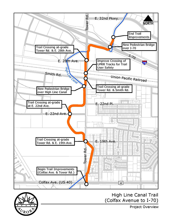
The city of Aurora, in collaboration with American Civil Constructors, will start work Jan. 30 on a multi-use trail to close the gap along the High Line Canal between Colfax Avenue and recent improvements constructed north of I-70.
The High Line Canal Trail construction project, which spans nearly two miles, will include:
A continuous 8-foot-wide concrete trail
Two pedestrian bridges (one to cross over the canal just south of Smith Road and one over I-70 just east of the Tower Road interchange)
An upgraded railroad crossing to promote pedestrian and cyclist safety
Access to the 71-mile High Line Canal Regional Trail within the metro area
Designed with community input, the new trail will provide close-to-home, accessible recreation opportunities within the community and serve a diverse population that may otherwise have limited opportunities to access natural areas. View additional details regarding the community input process, project files and more at EngageAurora.org/HLCT.
The city has been granted federal funds through the Denver Regional Council of Governments to help pay for the trail construction with city capital improvement funding used as a match amount. Additional funding partners consist of the Conservation Trust Fund, Adams County Open Space Grant, and the Adams County Open Space Tax Shareback.
Construction Updates
American Civil Constructors will begin work on the project’s south end and between East Colfax and East 19th avenues on the east side of Tower Road and along the canal.
Vehicular and pedestrian travelers can expect intermittent delays in these areas for the first two months. Alternate routes are recommended when possible.
The contractor also plans to start working on the bridge abutment just south of I-70 when the project kicks off.
Traffic impacts will be posted on this page as the project progresses.
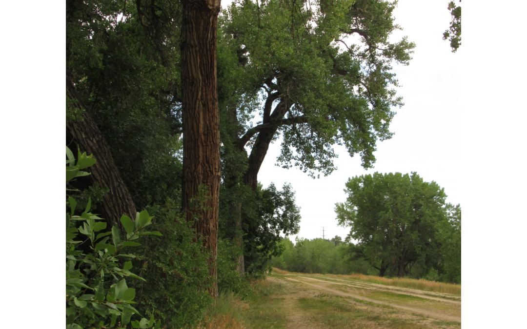
Old cottonwoods line the banks and trails of the historic Highline Canal, which is being converted into an ultra modern stormwater system even as its trail systems continue to serve metro area residents. July 21, 2020 Credit: Jerd Smith via Water Education Colorado
Click the link to read the article on the NOAA website:
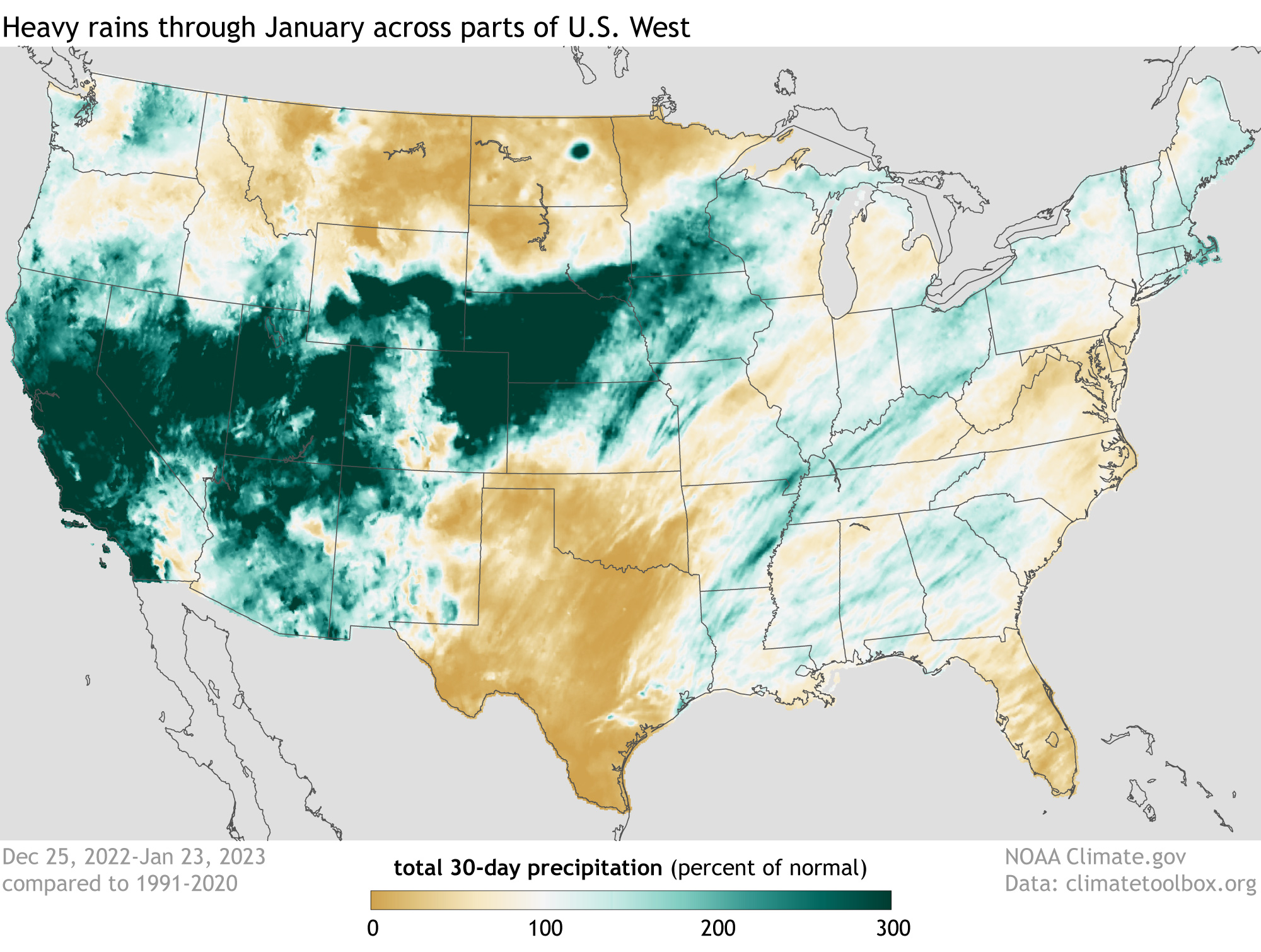
A series of nine atmospheric rivers starting in late December 2022 through mid-January 2023 dropped feet of rain and snow across California and other parts of the West Coast, according to a special drought update from Drought.gov. The tremendous amounts of precipitation caused major transportation issues, as well as landslides and flooding, but it also led to drought improvements across a large chunk of the western United States.
Percent of normal U.S. precipitation over the past 30 days (December 25, 2022, through January 23, 2023) after a series of weather events known as atmospheric rivers, fueled by tropical moisture, flooded the U.S. West with rain and snow. Places where precipitation was less than 100 percent of the 1991-2020 average are brown; places where precipitation was 300 percent or more than average are blue-green. NOAA Climate.gov image, based on analysis and data provided by the Climate Mapper website.
In just three weeks, 80 percent of the average seasonal snowpack fell in California, with 11.2 inches of precipitation being observed on average for the entire state. Said another way, almost half (46%) of the average statewide water-year precipitation fell in just three weeks.
No landscape can handle this much precipitation in so short a time period. Flooding, mudslides, debris flows and dangerous travel conditions were the norm for California at the start of 2023. But in positive news, the heavy rains and snows increased soil moisture and snowpack, and filled many reservoirs that were quite below-average heading into this year.
This moisture resulted in widespread improvement in drought conditions out West, especially in California. But the drought isn’t over in many places, where long-term impacts to groundwater, reservoirs, and ecosystems persist despite the recent downpours. According to the Drought.gov, 92 percent of California was still in some level of drought based on data through January 17. (The next update will be tomorrow, January 26). Long-term drought also still persists in areas like the Colorado River Basin.
The Bureau of Land Management and a nonprofit entity have teamed up once again on an acquisition by the federal agency of land along the lower Gunnison River, this time involving a 26.32-acre parcel in Mesa County. The BLM’s Grand Junction Field Office partnered with the Western Rivers Conservancy on the acquisition of the Meridian Junction property, on the east side of the river just north of the Mesa/Delta county line. The acquisition furthers partnership efforts to conserve and protect resources for future generations, the agency said in a news release. The land is within the Dominguez-Escalante National Conservation Area, and was bought with money from the federal Land and Water Conservation Fund.
Suncor refinery Commerce City. Photo credit: Allen Best/Big Pivots
Click the link to read the article on The Denver Post website (Noelle Phillips). Here’s an excerpt:
Suncor filed a notice with the Colorado Department of Public Health and Environment to notify the state of the benzene discharge into Sand Creek, reporting levels that were 40% to 80% above permitted allowances, according to a letter sent Friday [January 20, 2023] to the department’s Water Quality Protection Section. During a Dec. 24 fire at Suncor’s Plant 1, which refines oil into gasoline and other fuels, benzene containing hydrocarbon entered the refinery’s stormwater system, according to the letter. Testing found benzene levels at 7 micrograms per liter on Jan. 4 and 9 micrograms per liter on Jan. 5, the letter said. The refinery’s permit allows a daily maximum of 5 micrograms per liter to be discharged into Sand Creek. The excess benzene was first reported by Colorado Public Radio…
After discovering elevated benzene concentrations in the creek next to its refinery, Suncor isolated the affected water so it could be treated to reduce the chemical to below permitted levels, the letter said. Testing on Jan. 6 showed benzene concentrations at 1 microgram per liter. Loa Esquilin Garcia, a Suncor spokeswoman, said Tuesday that she would not be able to answer The Denver Post’s questions about the spill, including what the company is doing to prevent it from happening again, until the end of business on Wednesday.
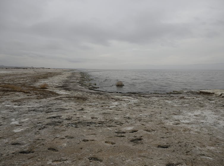
The Salton Sea spreads across a remote valley in California’s lower Colorado Desert, 40 miles (65 kilometers) from the Mexican border. For birds migrating along the Pacific coast, it’s an avian Grand Central Station. In midwinter tens of thousands of snow geese, ducks, pelicans, gulls and other species forage on and around the lake. Hundreds of other species nest there year-round or use it as a rest stop during spring and fall migration.
At the dawn of the 20th century, this massive oasis didn’t even exist. It was created in 1905 when Colorado River floodwaters breached an irrigation canal under construction in Southern California and flowed into a basin that had flooded in the past. In earlier years, the sea covered roughly 40 square miles more than its current size of 343 square miles (890 square kilometers).
Now, however, this resource is in trouble. Wasteful irrigation practices that maintained the sea have been reduced, and excess water is now being transferred to thirsty coastal cities instead. The sea’s volume has declined to roughly 4.6 million acre-feet, losing nearly 3 million acre-feet since the mid-2000s. (An acre-foot is about 326,000 gallons – the amount of water required to cover an acre of land to a depth of one foot).
In November 2022, the federal government pledged US$250 million for environmental restoration and dust suppression at the Salton Sea. It’s a historic contribution, but experts agree that other critical steps are needed.
We just completed more than a year of service to the California Salton Sea Management Program’s Independent Review Panel, which was charged with evaluating proposals to import water to the sea. In our view, the panel’s recommendations represent the best path forward. They also reflect the complexity of managing water in the increasingly dry U.S. Southwest, where other water bodies, such as Utah’s Great Salt Lake, share the same general challenges of net water loss.
An ecosystem on the brink
There’s no question that the Salton Sea desperately needs a fix. Rising salinity threatens worms, crustaceans and other organisms that make up the base of the sea’s food web and has killed off many of its fish species. Without intervention, the sea’s entire ecosystem could collapse.
Without government intervention, the sea would reach a lower equilibrium size by 2045 that matches smaller inflows with evaporation losses. Even greater areas of playa would be exposed, potentially generating even more airborne dust. https://www.youtube.com/embed/KOcB0A3K_bw?wmode=transparent&start=13 Land managers and local residents explain how the Salton Sea’s decline is affecting people and wildlife.
These schemes called for building immense desalination plants along the Sea of Cortez, up to 10 times bigger than California’s Claude “Bud” Lewis plant in Carlsbad – the largest such facility in the United States.
The proposals could not overcome three significant problems. First, they were projected to cost many tens of billions of dollars and take more than 20 years to complete. Second, they threatened to inflict nasty environmental consequences on the Sea of Cortez, dumping huge quantities of brine into sensitive and protected marine ecosystems and turning pristine beaches into industrial zones. Third, Mexico would derive little benefit from building a huge desalination plant in a remote area, other than some jobs from building and running the plant. https://cdn.knightlab.com/libs/juxtapose/latest/embed/index.html?uid=1c70a2bc-9035-11ed-b5bd-6595d9b17862 These satellite photos show how the Salton Sea shrank between 1984 and 2015, exposing dry playa around its edges (move slider to compare years).
Focus on salinity, not size
Ultimately, the panel concluded that expanding the Salton Sea to its former size was less important than controlling its salinity. The panel made four recommendations that center on building a desalination plant at the Salton Sea to the treat water that’s already there.
This plant would remove 200 million gallons of high-salinity water daily from the Salton Sea and produce 100 million gallons per day of desalinated water, which would be returned to the Salton Sea. In short order, this exchange would begin to significantly lower its overall salinity.
A desalination plant using reverse osmosis generates a brine stream equal to approximately half the volume of the treated seawater. Accordingly, the panel called for California to negotiate a voluntary paid transfer program in which the state would pay farmers to transfer enough water to the Salton Sea to replace the volume of brine removed at the desalination plant. The net effect would keep the sea from becoming even smaller and hasten the process of lowering salinity.
The desalination plant would generate an immense quantity of salt, which would require careful disposal. The panel recommended drying out the brine in evaporation ponds and transferring dried salts from the ponds to landfills or industrial uses.
Finally, the panel called for California to step up support for an aggressive program to stabilize the exposed playa. Techniques could include planting vegetation on the playa and plowing long rows of furrows to reduce dust mobilization during wind storms. The estimated total cost for this plan is $63 billion, compared with $95 billion-$148 billion for various proposals to desalinate and import water from the Sea of Cortez.
Since 2020, the state has conducted pilot projects to reduce dust blowing off the playa, with promising early results. The federal government’s $250 million pledge will enable this work to move more quickly.
Stabilizing the playa is essential to address significant public health concerns associated with windborne dust, although more must be done regionally to fully address air quality problems.
Looking forward, not backward
This approach will not satisfy critics who want to restore the Salton Sea to its maximum volume. These advocates recall the mid-20th century when the sea was a tourism draw and would like to reconnect the few small towns that once bordered the sea, which are now separated by extensive playa. Expanding the sea to its original size also would address concerns about playa-sourced air pollution.
In our view, however, the panel’s recommendations offer a genuine opportunity to solve the main problems: blowing dust and increasing salinity. This solution is more likely to actually be implemented than an enormous binational desalination project. It would happen more quickly, at about half the cost of the binational importation options.
We believe that the sooner California officials accept the reality of a smaller Salton Sea, the sooner the state can move ahead, focusing on air quality improvement and ecological restoration.
Sources/Usage: Public Domain. Visit Media to see details.
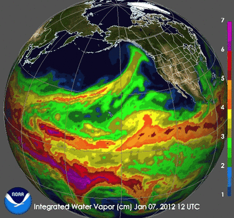
Animation showing AR plumes over the Pacific during January 2012.
Click the link to read the article on the NIDIS website:
A Series of Atmospheric Rivers Have Hit Parts of the West. What Does This Mean for Drought?
Key Points
Starting on December 26, 2022, a series of 9 atmospheric rivers(ARs) brought significant amounts of rain, snow, and wind to California and other parts of the western United States over a 3-week period.
80% of a full seasonal snowpack was deposited in California during these storms. Statewide, precipitation over these 3 weeks was 11.2 inches, which is 46% of a full water year.
The AR events have been a big boost to mountain snowpack across the West, where snow water equivalent (SWE) totals are well above normal for this time of year except for many parts of the Cascades and the Northern Rockies, where accumulation has slowed since the beginning of January.
Given that it is still early in the snow accumulation season, water year totals could either be moderate if the rest of the winter and spring are dry, or relatively high if precipitation continues.
According to Natural Resources Conservation Service SNOTEL, as of end of day January 22, 2023, the snow water equivalent for the California Region is 215%, the Great Basin is 206%, and the Upper and Lower Colorado River Basins are 146% and 218%, respectively.
These recent storms improved drought conditions by increasing soil moisture throughout much of the West, especially in California. The amount of water stored in many reservoirs increased, but some are still well below historical averages for this time of year.
Despite the drought improvements in many areas, long-term drought persists in parts of the West. Reservoir storage deficits, such as those within the Colorado River system, and groundwater and soil moisture deficits (especially in the Northwest) that have built up over many months to years will require additional precipitation to overcome.
Pockets of extreme (D3) and exceptional (D4) drought continue to persist in Utah, Nevada, and central and eastern Oregon.
The long sequence of ARs that made landfall in California and the amounts of precipitation that fell over this relatively short period of time caused flooding, dangerous travel conditions, and debris flows.
The NOAA Climate Prediction Center’s Seasonal Outlook shows chances of drought removal or improvement for central and northern California, Oregon, Idaho, and the northern Rockies, with drought remaining in southern California, Nevada, and Utah. The current forecasts indicate AR activity could pick up again in early February, but the storm tracks are still uncertain.
West snowpack. basin-filled map January 28, 2023 via the NRCS.
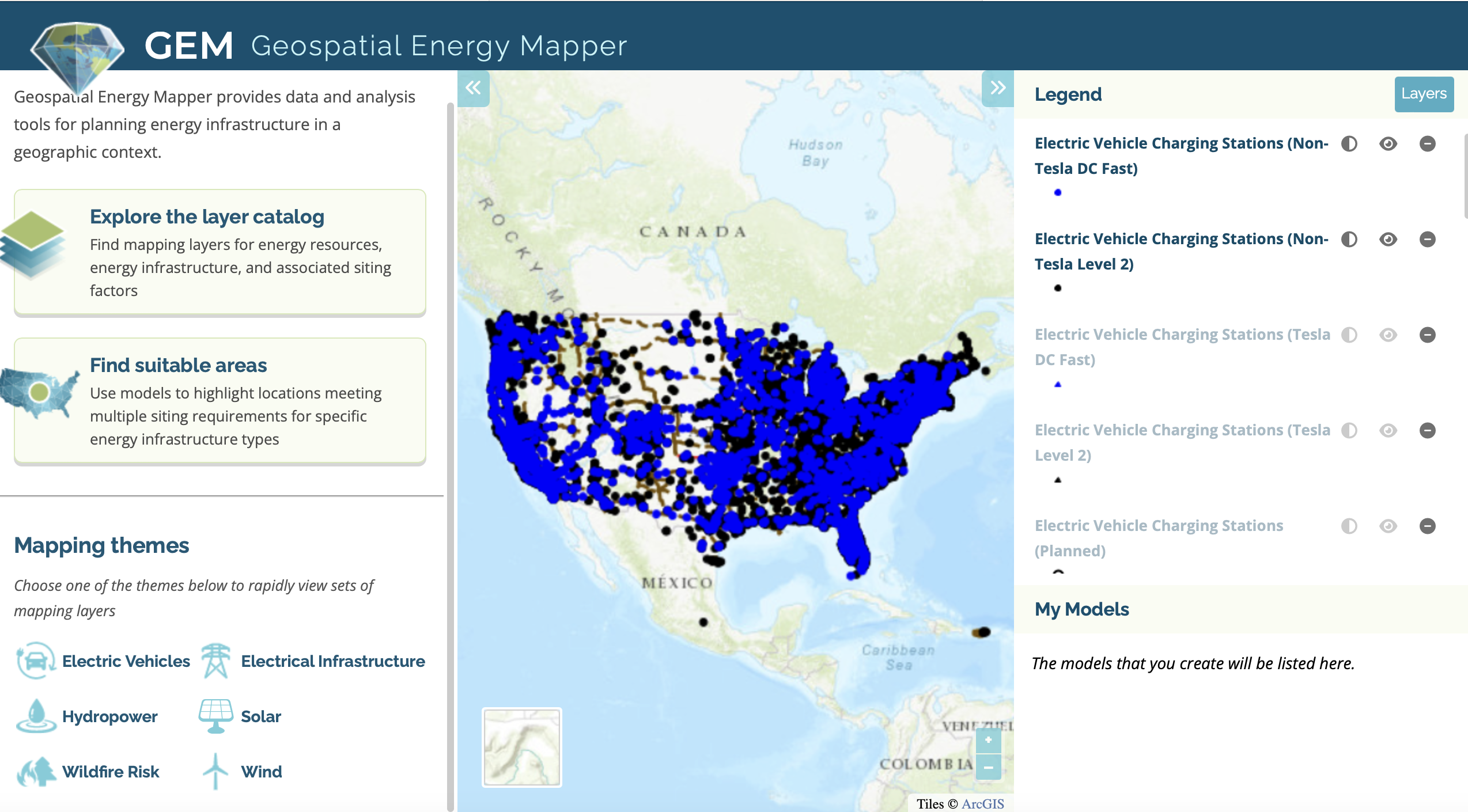
GEM is an interactive web-based decision support system that allows users to locate areas with high suitability for clean power generation and potential energy transmission corridors in the United States. Browse and download data layers, or create a custom suitability model to identify areas for energy development.
While much of the country was relaxing over the winter holidays, federal lawmakers remained busy.
Before ending its session and swearing in new members, Congress passed a fiscal year 2023 budget with key provisions for water infrastructure and disaster recovery. That’s in addition to approving legislation that authorizes Army Corps of Engineers projects for flood protection, navigation, and environmental restoration.
Combined, the two bills run to more than 8,000 pages. Water sector advocates, though confounded by how some infrastructure funds are being allocated, were generally pleased with what the bills contain.
“Anybody who cares about water should be excited about what we accomplished at the end of last year,” Mae Stevens told Circle of Blue. Stevens, who works with environmental groups and utilities, is chair of the water practice at Banner Public Affairs, a lobby group.
The Water Resources Development Act, or WRDA, is the legislation that authorizes Army Corps of Engineers projects. The bill focuses on flood protection, commercial waterways, and improving community engagement, particularly with Native American tribes and communities historically burdened by pollution.
Major projects authorized or modified in WRDA include:
$1.8 billion Upper Barataria Basin project, a 30-mile levee to protect seven southeastern Louisiana parishes from storm surges.
$34.4 billion Coastal Texas Protection and Restoration project, a massive system of levees, flood gates, dunes, and marsh restoration to safeguard the Texas Gulf Coast from hurricane storm surges.
$3.2 billion for a larger lock at Soo Locks, a pivotal transit point for Great Lakes commercial shipping.
WRDA also made it easier for the Army Corps to deploy natural features such as marshes and dunes to guard against floods. And it authorized the Army Corps to study a second drinking water source or additional water storage for Washington, D.C.
The capital’s water supply is vulnerable, said Stevens, who worked on two previous WRDA bills as part of Sen. Ben Cardin’s staff. The Potomac River — the city’s sole drinking water source — could be compromised by industrial accidents, oil spills, or other incidents. Shutting down the Potomac water intake would put the city in a serious bind.
In an action separate from WRDA, the Army Corps issued final permits for a $2.3 billion environmental restoration project to rebuild eroding land along the Louisiana coast.
The Mid-Barataria Sediment Diversion, a state project, will provide an off-ramp for sediment-laden water from the Mississippi River. Those land-building particles will be diverted during periods of high flow. Exiting the river at a point south of New Orleans, the sediment will be funneled to the Barataria Basin, where it is intended to reestablish coastal wetlands and protect inland areas from storm surges.
WRDA authorizes projects but does not fund them. Allocating money is the purpose of the appropriations bill.
That bill identified water infrastructure priorities. It allocated $140 million to rebuild water treatment facilities in New Mexico that were affected by last year’s Hermit’s Peak/Calf Canyon fire, the largest in state history.
The bill maintained the Clean Water and Drinking Water State Revolving Funds at 2022 spending levels. These low-interest loan funds are two primary sources of federal funding for water infrastructure.
Funding this year for the Clean Water SRF is $1.6 billion, while the Drinking Water SRF is $1.1 billion. Both will get several billion dollars annually over the next four years in supplemental funding from the Infrastructure Investment and Jobs Act.
Water groups, however, are upset with operational changes to the funds. Earmarks, which returned to the budget process last year, are being subtracted from the SRF totals. For water infrastructure, earmarks amounted to roughly half of the total funding for the SRFs in this budget.
The remaining SRF dollars will be distributed to the states according to a standard formula. This creates winners and losers. If your senator was especially good at lobbying for dollars, your state gets more than its usual SRF share.
For utilities in losing states, the result is a scramble for the leftovers, Stevens said. There might not be enough money in the SRFs for projects that would have been funded in the past.
“It means that every utility now really, really, really needs to go and get earmarks because they can’t count on the SRF funding in the state to be high enough,” she said.
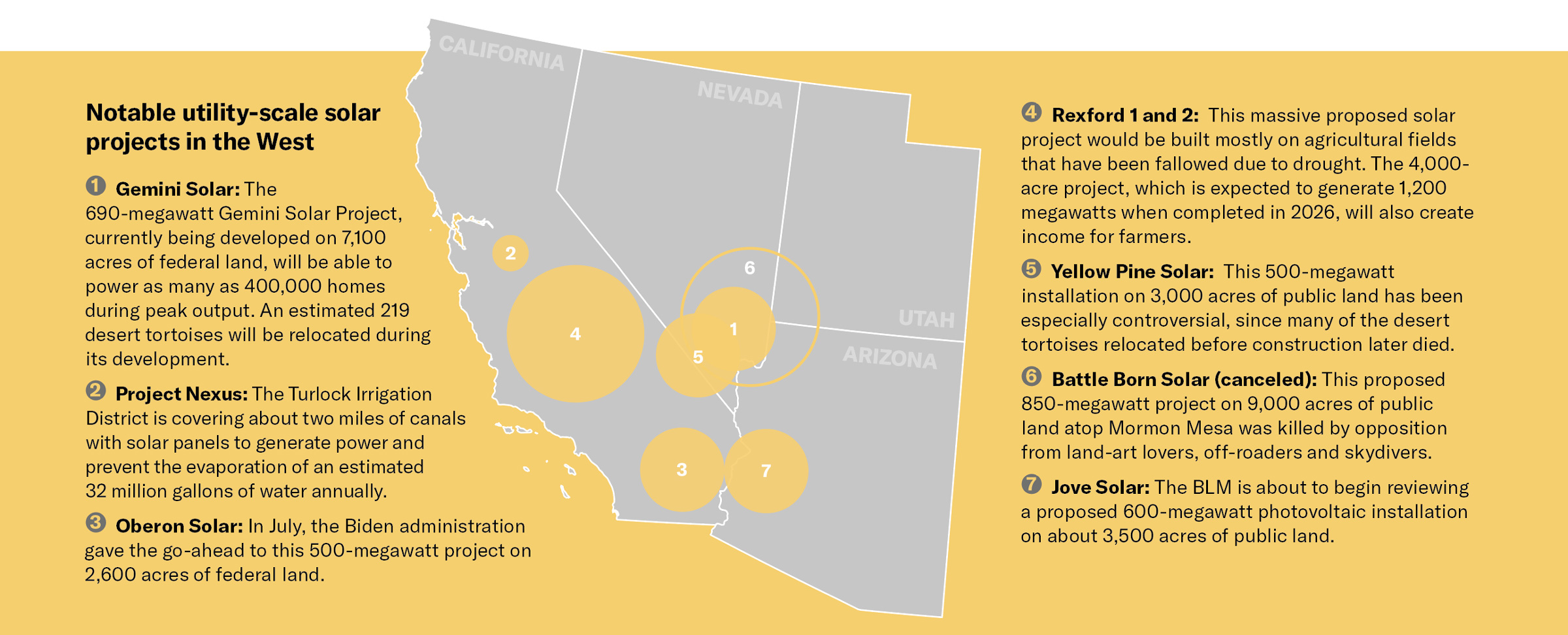
On a sunny dayin early December, Interior Secretary Deb Haaland stood on a dais outside the Phoenix exurb of Buckeye, Arizona, where about 3,000 acres of desert had been scraped clean and leveled to make way for the Sonoran Solar Project, which will soon provide power to some 91,000 homes.
Haaland came with good news for utility-scale solar and climate hawks: The Bureau of Land Management would review three massive solar projects proposed in Arizona and hoped to expedite permitting for solar energy on federal lands in Arizona, California, Nevada, New Mexico and Utah. “Solar energy projects on public lands will help communities across the country be a part of the climate solution, while creating good-paying jobs,” Haaland said.
But these projects could also potentially uproot imperiled Joshua trees and cactus, kill or displace threatened desert tortoises, block wildlife migratory paths and harm local communities. This puts conservationists and policymakers in the difficult position of having to choose between saving the desert — or the planet.
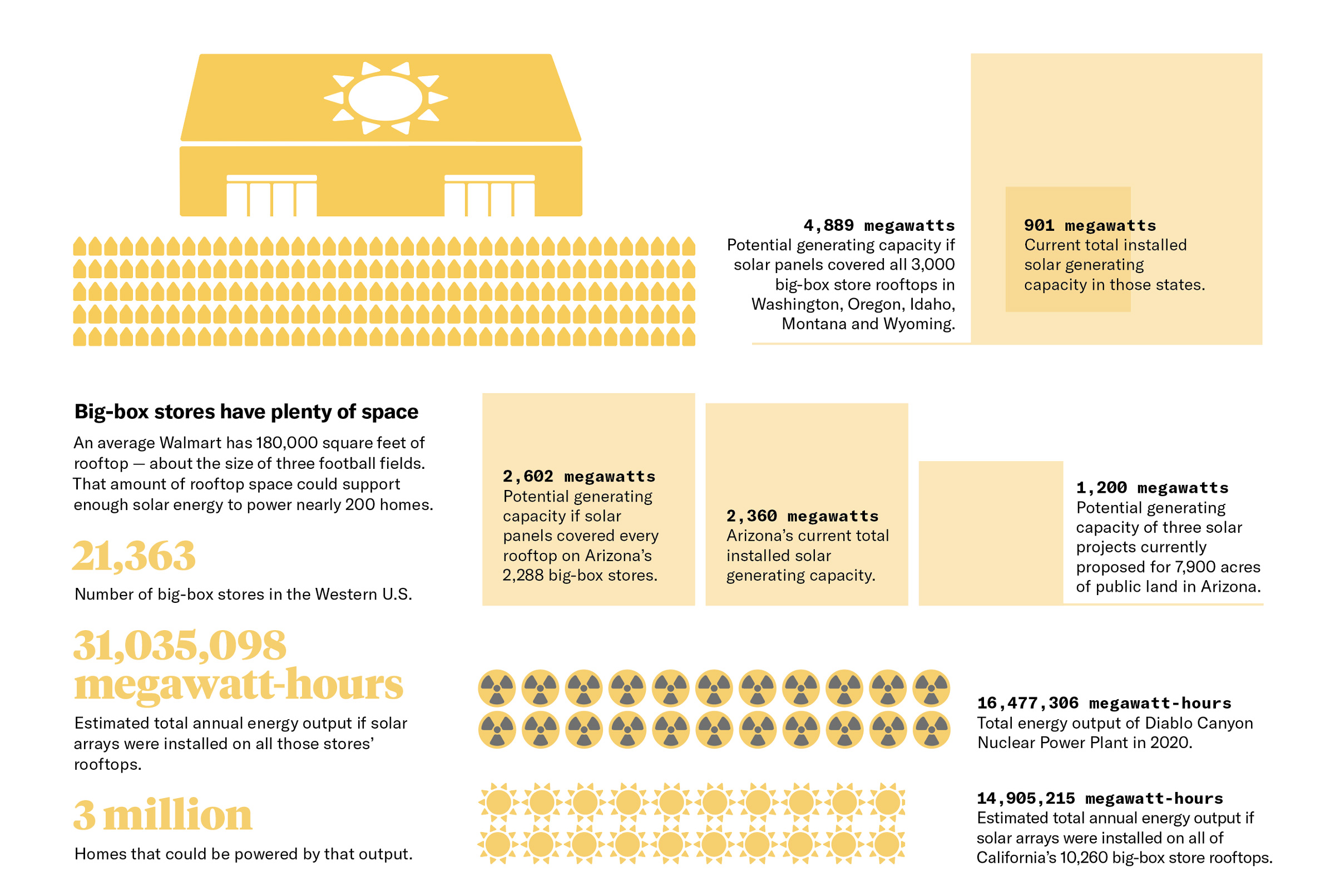
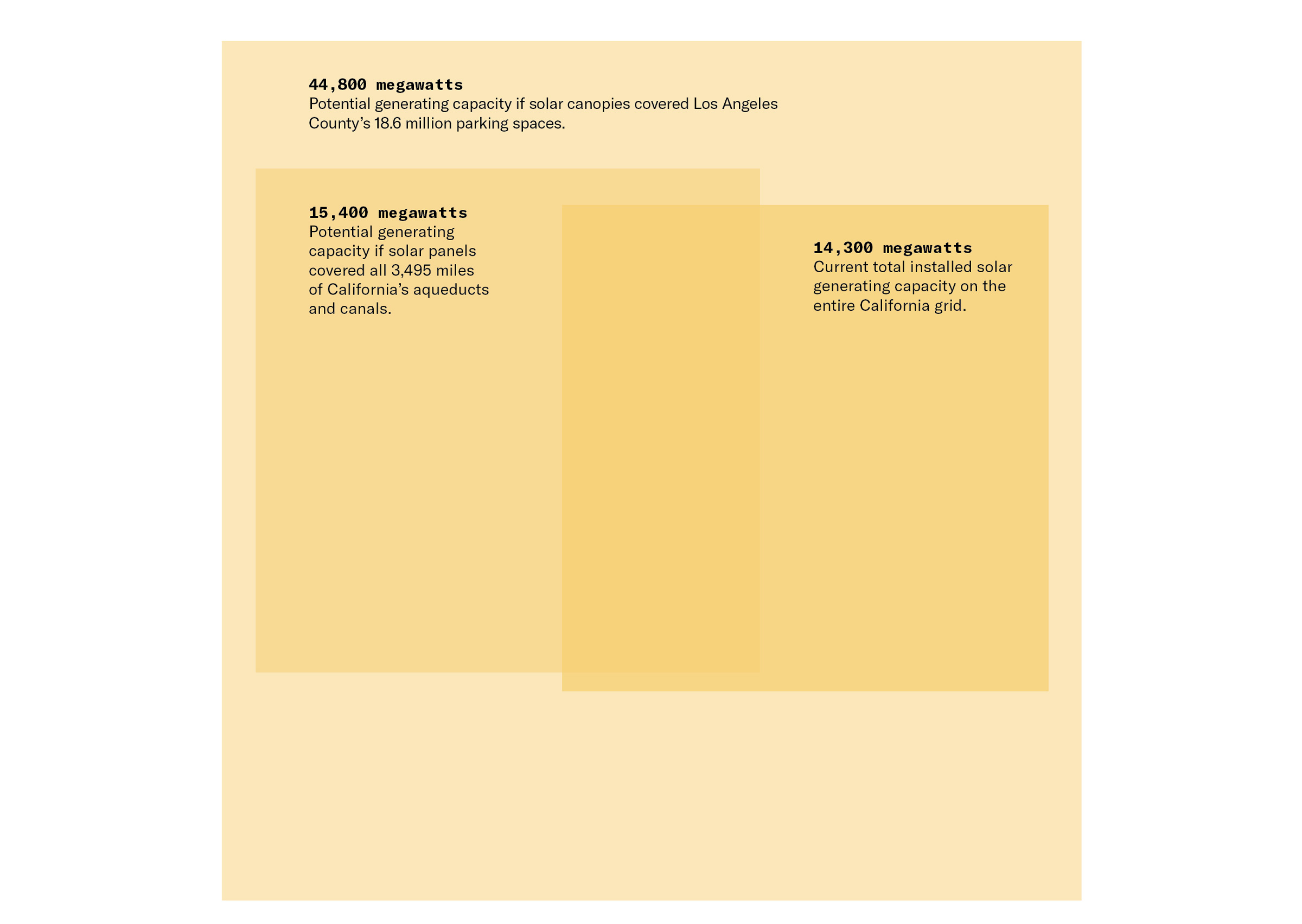
There are other ways, however, and other locations for solar panels, from residential rooftops to farm fields fallowed by drought. France, for instance, recently required large parking lots to be covered by solar canopies that shade cars and provide up to 11 gigawatts of new generating capacity, equivalent to about 10 times the three proposed projects in Arizona.
This inspired us to ask: How much power could be generated by slapping solar panels not only over the West’s vast parking lots, but also on its 21,000 big-box store rooftops? We did the math, and this is what we found out.
1,155 megawatts Estimated generating capacity if solar panels covered all 370 miles of the Los Angeles Aqueduct, as LA officials propose.
37,500 gigawatt-hours per year Energy output of solar canopies if all of Phoenix, Arizona’s 12.2 million parking spots were covered.
139 Number of desert tortoises relocated to make way for the Yellow Pine Solar Project in southern Nevada in 2021. Within a few weeks, 30 of them were killed, possibly by badgers.
4,200 (215,000 acres) Grazing leases bought and retired in the Mojave Desert in California by Avantus this year to protect wildlife habitat and Joshua trees. The Onyx Conservation Project is a partnership with federal and state land management agencies to “offset” the impacts of the company’s developments elsewhere in the region.
1.3 million Estimated number of Joshua trees destroyed by the 2020 Dome Fire, thought to be exacerbated by climate change, in the Mojave National Preserve in California.
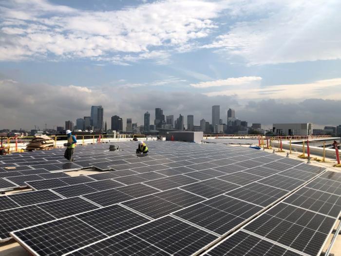
Crews install solar panels on top of Denver Water’s administration building in 2019. Photo credit: Denver Water
Note: We worked from two figures that were calculated by Greta Bolinger and Mark Bolinger in “Land Requirements for Utility-Scale PV: An Empirical Update on Power and Energy Density,” published in the IEEE Journal of Photovoltaics in March 2022:
Power density: .35 megawatts per acre for utility-scale, fixed-tilt photovoltaics. Most residential solar systems are about 400 watts, or .0004 megawatts.
Energy density: 447 megawatt-hours per year per acre for utility-scale fixed-tilt photovoltaics. An average American household uses about 10 megawatt-hours of electricity annually.
We used Environment America’s figures and Google Earth’s measurements to determine that an average big-box store has 3.25 acres of rooftop. We used American Planning Association calculations to estimate that one acre contains about 145 parking spaces.
Additional sources: BLM, EIA, Basin & Range Watch, UC Davis, Berkeley Lab, Avantus, Primergy, American Planning Association, USGS, Environment America, Google Earth.
The reservoir would be a joint project between SJWCD and the PAWSD called the San Juan River Headwaters Project. In 2008, SJWCD and PAWSD collaborated on the purchase of the property, also known as Running Iron Ranch, with the goal to even- tually build a water storage facility on the parcel of land, which is more than 600 acres. The proposed reservoir would be an “off-channel” water storage facility being fed by a pre-existing agricultural ditch, Park Ditch…
According to the district’s strategic plan, “In 2004, the District and PAWSD applied for a junior water right for a larger reservoir in Dry Gulch, a refill right, and specific filling sources and rates for it. Trout Unlimited opposed those claims, leading to protracted litigation and new standards from the Colorado Supreme Court for evaluating conditional water rights owned by municipal providers. The District, PAWSD, and Trout Unlimited eventually stipulated to a decree providing for a maximum storage capacity of 11,000 acre-feet for Dry Gulch Reservoir and other limitations on its use.”
More recently, SJWCD sought more accurate information on projections for future water needs, hiring the Lakewood-based water consultant company Wilson Water Group to conduct the analysis. The resulting study was a 24- page “analysis of current and future water supply and demand through 2050 in the Upper San Juan River basin.”