
Colleen E. Reid, University of Colorado Boulder; Joost de Gouw, University of Colorado Boulder, and Michael Hannigan, University of Colorado Boulder
This article is part of a collaboration with Boulder Reporting Lab, The Center for Environmental Journalism at the University of Colorado Boulder, KUNC public radio and The Conversation U.S. to explore the impacts of the devastating Marshall Fire one year after the blaze. The series can be found at the Boulder Reporting Lab.
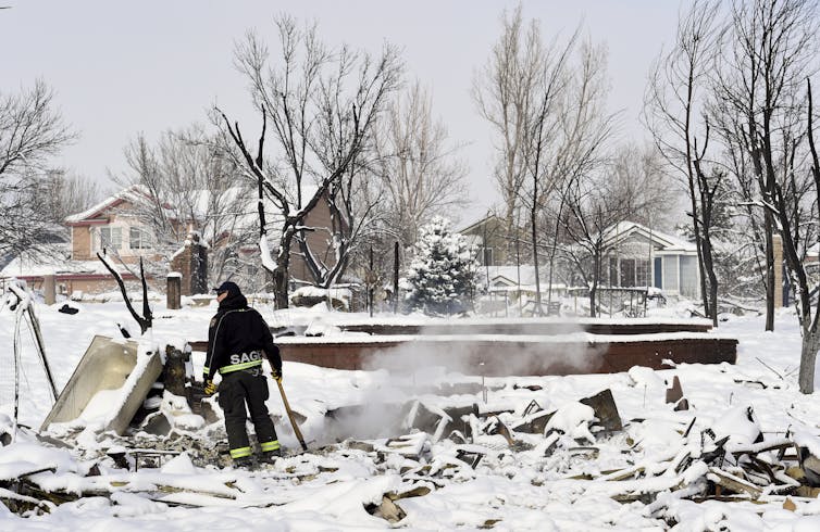
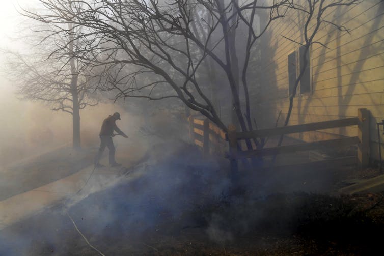
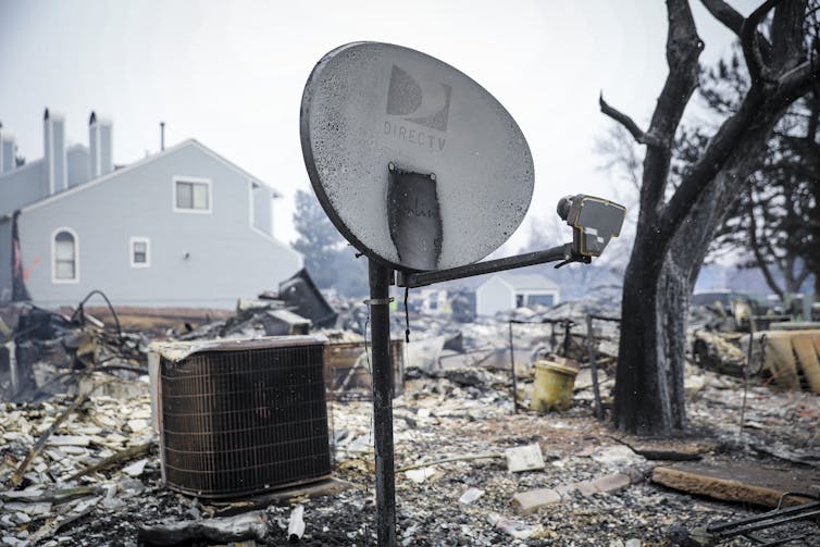
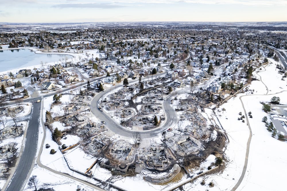
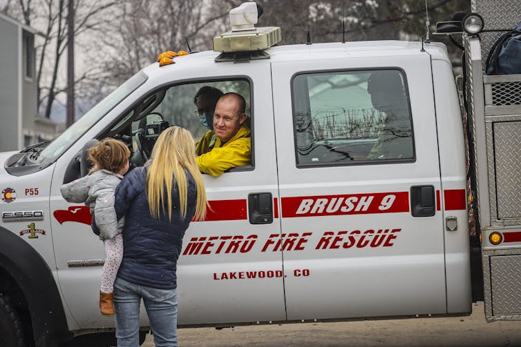
On Dec. 30, 2021, one of the most destructive wildfires on record in Colorado swept through neighborhoods just a few miles from our offices at the University of Colorado Boulder. The flames destroyed over 1,000 buildings, yet when we drove through the affected neighborhoods, some houses were still completely intact right next to homes where nothing was left to burn.
Although the people who lived in these still-standing homes were spared the loss of everything they owned, when they returned after the fire, they found another disaster.
Noxious smells and ash on their windowsills and doorways initially made their homes unlivable – and potentially hazardous to human health. Some of these residents were still reporting health problems from being in their homes months later, even after the homes had been cleaned.
We study wildfires and their health effects, and we knew people who lost their homes in the Marshall Fire. We also knew we had to act fast to study the fire’s impact so lessons from the Marshall Fire could help homeowners elsewhere avoid similar hazards in the future.
Early on, because of our expertise on air quality and health, members of our community reached out to us to ask how they could remediate their homes from the smells and hidden ash, and what health risks they should be concerned about.
But this fire was nothing like the wildfires that our research groups at the University of Colorado had previously studied. Most of what burned on that day was human-made rather than vegetation. When human-made materials like electronics, vehicles and home furnishings burn, they release different types of air pollutants and may affect health differently compared to when vegetation burns.
The outdoor air pollution was less of an issue because the wildfire was short-lived – the powerful winds that fueled the fire quieted down and changed direction about 11 hours after the fire started, and the first snow of the season finally fell. This snowfall ended the fire and cleaned the outside air of pollution.
The key concern was what chemicals lingered inside the undestroyed homes – soaked up into the fabrics of carpets, sofas, drywall, air vents and more – that would slowly release into the home for some time after the fire.
We hypothesized that there were lots of volatile organic compounds (VOCs) – toxic gases, which were emitted during the fire that had seeped into homes and become embedded in the fabrics and building materials. Of particular concern were aromatic compounds like benzene, a known carcinogen, and polycyclic aromatic hydrocarbons (PAHs), which are emitted from wildfires and have known health effects. In addition, we were worried about metals in the ash and soot deposited in homes, and the potential for it to become suspended in the air again when people returned and heating systems came on.
Despite knowing that some of these gases were toxic, we did not know the levels inside the homes, or what remediation efforts to suggest to residents, because little scientific research had been published on wildland-urban interface fires like this one. We realized that we needed to do some of that research to help our own community – and the next community affected by a wildland-urban interface fire.
Many community members volunteered their homes for study sites. When we toured these still-standing homes 10 days after the fire, we saw what a rapid evacuation looks like, with lunch in the process of being made, laundry being folded, toys in the middle of pretend play … and dust, lots and lots of dust resulting from the fire.
We collected dust samples in about a dozen homes and then analyzed the samples in our labs.

We looked for molecules that could help us think about the origin of the dust. Not surprisingly, the dust was a combination of windblown soil, ash from the fire and typical household dust. That ash was high in typical combustion byproducts that are known to be toxic, and there was lots of ash, so cleaning up all the dust was important to remediation.
The homes that had been exposed to heavy smoke also still smelled like a chemical fire. A colleague likened it to the smell of gunpowder.
As quickly as we could, we moved a state-of-the-art mass spectrometer into one of the most heavily affected homes in Superior and made measurements of airborne pollutants for five weeks.
Shortly after the Marshall Fire, we found that many pollutants, including PAHs, were indeed at higher levels inside smoke-affected homes than we would expect, but in early February these pollutants had decreased to more normal levels.
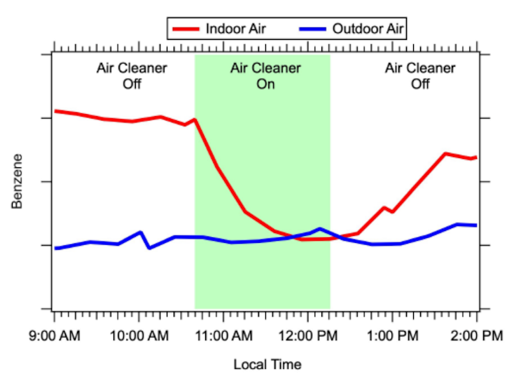
We researched ways in which people could protect themselves and found through experiments that air filters with activated carbon could provide excellent temporary relief from the indoor pollutants.
We also observed the results of professional remediation efforts. We are still poring over the air pollution data to understand which materials that burned, such as plastics, car tires, furniture, carpet and roofing material, contributed the most to the air pollutants we observed in the homes.
In addition to the air pollution and ash concerns, people living in the neighborhoods that burned are concerned about their health.
In an initial survey, residents reported a variety of symptoms that they think may be due to the smoke or air quality concerns of the fire, with the most common being itchy or watery eyes, headaches, dry cough and sore throat. More than half of respondents also reported disrupted sleep due to the stress of the fire, and almost a quarter attributed headaches at least in part to the stress of the event.
The physical symptoms could be due to the exposure during the fire. However, of those who have moved back into smoke-damaged homes, they report the symptoms most often inside their homes.
This fall, more than nine months after the fire, some residents reported rashes and burning sensations despite having cleaned their homes of ash and the smell of VOCs having dissipated. Another round of surveys is now helping gather more information about lingering symptoms. In addition to physical health symptoms, we are also asking questions about mental health, which is a growing concern from so-called natural disasters.
While we know that the VOC concentrations inside the homes that we worked in have returned to normal levels, some individuals may be more sensitive than others. And while there has been research into the health effects of some VOCs, not all have been studied extensively, nor have studies looked at the health impacts of combinations of VOCs.
As global temperatures rise and more people move into once-wild landscapes at the edges of cities, the risk of wildfires spreading into urban areas rises. We hope that our work can help people deal with the air pollution aftermath of future blazes.
Colleen E. Reid, Assistant Professor of Geography, University of Colorado Boulder; Joost de Gouw, Professor of Chemistry, University of Colorado Boulder, and Michael Hannigan, Professor, University of Colorado Boulder
This article is republished from The Conversation under a Creative Commons license. Read the original article.

Click the link to read the article on the KSJD website (Gavin McGough). Here’s an excerpt:
The Dolores River starts high in the San Juans southwest of Telluride, passes through Dolores, Colorado, where it fills the Reservoir at McPhee Dam. From then on it trickles north through hundreds of miles of desert, meeting the San Miguel and feeding eventually into the Colorado River. Those who have boated it say it’s a river like no other.
“You start below the dam and you head into the Ponderosa Gorge with these big canyon walls and amazing majestic Ponderosa Pines, and you start to see more and more of this red rock coming out,” said Amber Clark, director of Dolores River Boating Advocates (DRBA) which promotes stewardship and recreation along the river.
“Then you transition down into less trees and more red rock canyon walls, and the Wilderness Study Area, and at different places it opens up more, and it’s kind of this ever-changing landscape, but the majesty of it never diminishes,” she said…
The DRBA is one of dozens of stakeholders who have been working to protect the Dolores as a National Conservation Area, or an NCA. Some rivers are protected by Congress under The Wild and Scenic Rivers Act, but protection as an NCA is less controversial, especially amongst agricultural interests. Al Heaton, a cattle rancher in Dolores, is involved in the conservation effort.
“Wild and Scenic comes with some rules and regulations, some laws, that are pretty dramatic and would affect a lot of things, private property and things down the river,” said Heaton.
“Of course, grazing could continue in a Wild and Scenic setting but it could also be restricted, so I felt there had to be a better way.”

Click the link to read the article on The Walton Family Foundation website (Sheldon Alberts):
Time has not been kind to our rivers. For centuries, humans have diminished, degraded and simplified rivers around the world, creating unhealthy waterways that have lost ecological value.
The good news is that our collective understanding of how to restore rivers is improving, with a greater focus on using natural systems to meet society’s needs while also protecting the environment. With nature-based management, we have an opportunity to rebuild rivers with the space and freedom they need to thrive. In turn, these healthier rivers lead to healthier communities and a healthier planet.
I spoke with Peter Skidmore, senior program officer with the foundation’s Colorado River initiative, about how restoring river health through natural processes can help us in the battle against climate change. He is the co-author of a recent article in the journal Anthropocene exploring the issue.
Can you describe some of the ways that rivers have been degraded over the past several hundred years?
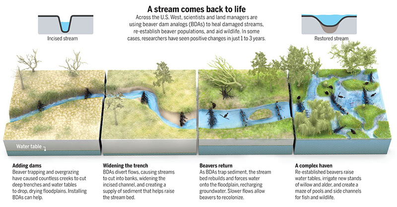
As a society, we have relegated rivers and streams to constrained channels. These simplified and stabilized channels have lost a lot of their freedom, complexity and biodiversity. Starting in the 19th century, the extermination of beavers fundamentally changed the character of streams as dams were removed and riparian wetlands disappeared. With development in their valley bottoms, rivers have also lost the space to run free, flood, erode and deposit soil. The construction of dams and diversions have further constricted river flows.
What are we learning about emerging opportunities to restore the health of rivers so they can provide critical ecosystem services?
There has been a lot of hard work done to restore river health over the past few decades, but we’ve fallen short in addressing the challenge at a scale to have lasting impact. Over this time, we learned a lot about the potential of “natural infrastructure” to better manage rivers and restore their health through dynamic, natural processes. That can mean removing constraints wherever possible – setting levees back, concentrating infrastructure at a few pinch points, reconnecting rivers to their floodplains and renewing native vegetation.

Is there an example of how natural infrastructure can restore river health and improve climate resiliency?
One way is by promoting the return of beavers and beaver-related wetlands that reintroduce much-needed complexity into river systems. Messy rivers and streams – with features like braided and irregular channels, wetlands, eroding banks and gravel bars – are more diverse, dynamic and healthy. A success story is Bridge Creek, in Oregon, where the installation of beaver-inspired natural dams led to the expansion of beaver activity. These structures create a virtuous cycle of restoration that slows down water flow, revives mountain meadows and recreate stream meanders and wetlands that are ultimately maintained forever by beavers. They help maintain and retain groundwater, provide natural firebreaks and refuge for wildlife, and can alleviate the sedimentation impacts of post-fire flooding. Since 2005, Bridge Creek has had a dramatic increase in aquatic habitat and native fish populations. In addition to those fish and wildlife benefits, scientists are also finding that this kind of low-cost, low-tech restoration helps with carbon sequestration, nutrient capture and moderation of stream flow and temperature – critical ecosystems services in the face of drought and climate change.

What potential does this kind of restoration have to increase climate resiliency if done on large scale?
River ecosystems have a tremendous capacity for passive restoration if given the freedom space for dynamic interactions between the channel and the floodplain. They can literally heal themselves, often more quickly and effectively than we can. Just like humans need exercise to stay healthy, rivers also need that exercise. They need the space to move around. That’s important because, right now, ongoing development is exacerbating the impacts of a warming climate and straining the capacity of aging, expensive gray infrastructure to provide water security and protection from floods and drought. Natural infrastructure holds the potential to be a cost-effective and self-sustaining way to improve environmental health. It can be a critical component in a mix of solutions to the social and ecological challenges posed by climate change.
How is the foundation supporting natural infrastructure in the Colorado River basin?
The foundation’s five-year Environment program strategy increases our efforts to improve river and watershed health by working to improve public policy so it promotes nature-based solutions, and leveraging funding to implement them on a larger scale. We’re working with partners to test and increase the use of nature-based solutions that improve water security for farms and cities and also provide environmental benefits. We’re investing in beaver-related restoration that re-establishes wetlands and begins to restore degraded stream systems. And we’ve initiated an effort to identify and map changes in vegetated wetlands and beaver ponds throughout the basin as a way to measure progress and assess the potential of this work to provide system-wide benefit for the Colorado River.


Click the link to read the article on the Northglenn Thornton Senitinel website (Luke Zarzecki). Here’s an excerpt:
Many members of Standley Lake’s boating community saw a huge aspect of their community taken away with the ban of trailered boats in 2019. [Gary] Gambino used to work a graveyard shift and after, went straight to the lake.
“I would come home, hook up my boat, go out onto Standley, take it out in the back bay anchor in and take my four hours of sleep,” he said…
With Westminster’s city council revisiting the item, Northglenn’s council sent a letter signed by all council members indicating they will not be revisiting the item.
“Northglenn’s water in Standley Lake is irreplaceable, valued at more than $209 million dollars. There is no level of risk that our community is willing to accept when it comes to protecting our drinking water supply,” the letter reads.
Click the link to read “Standley Lake heads toward fifth summer with a firm no to powerboats” on The Denver Post website (John Aguilar). Here’s an excerpt:
But Westminster Councilman Dave DeMott said it’s “not realistic” to operate on a zero-risk basis “as there is no area where zero risk exists in this world.” He’s heard from boating enthusiasts that they are “frustrated” with the ban, which was made permanent in late 2019…
Northglenn — along with Westminster, Thornton and the Farmers Reservoir and Irrigation Company — own the 42,000 acre-feet of water in the lake, which serves as the sole supply of drinking water for both Westminster and Northglenn. Standley Lake, which is fed by three canals diverted off of Clear Creek, accounts for about a quarter of Thornton’s drinking water supply. It, too, is in favor of maintaining the trailered boat ban. Any change in boating policy would have to be agreed to by the three cities…
Northglenn’s decision was likely re-affirmed by the September discovery of a single zebra mussel in Highline Lake State Park, northwest of Grand Junction. In late October, Colorado Parks & Wildlife announced more zebra mussels had been found in Highline Lake, giving the lake an official infestation listing. CPW says Highline Lake is currently the only Colorado body of water infested with zebra mussels. No quagga mussels are known to exist in the state, though Lake Powell in Utah has them.
“We don’t see the value in risking our drinking water supply for the benefit of a small group of people,” said Tami Moon, Northglenn’s environmental manager. “That is the only place we have to store our water.”

Click the link to read the article on the WyoFile website (Dustin Bleizeffer):
The Upper Colorado River Commission plans to revive a program that pays irrigators and other valid rights holders to voluntarily leave water in streams that feed the beleaguered Colorado River.
The System Conservation Pilot Program is one strategy among a handful that Upper Colorado River Basin states — Wyoming, Colorado, Utah and New Mexico — have offered to help satisfy their role in meeting a challenge by federal officials to conserve 2 million to 4 million acre-feet of water system-wide in 2023.
“The goal is to have water conservation projects underway in April 2023 to reduce consumptive uses in the Upper Basin Colorado River system,” the UCRC stated in a Dec. 14 press release. More “durable” and “longer-term” solutions are still needed, however, the UCRC said. “The SCPP is a significant step to begin to partially mitigate the water supply crisis in the Upper Colorado River Basin brought on by a drier climate and depleted storage.”
The SCPP was initially implemented from 2015 through 2018 using funds from Lower Colorado River Basin stakeholders, including large municipalities such as Las Vegas. This time around, the UCRC proposes to instead use $125 million from the Inflation Reduction Act — an appropriation that backers hope Congress will approve in a spending bill.
Water users have only until Feb. 1 to submit proposals in response to a call for applications that was issued Dec. 14.

The UCRC scrambled in recent months to relaunch the SCPP water conservation program under pressure to lay the groundwork for both short- and long-term water savings amidst a growing crisis along the Colorado River. The river system serves some 40 million people in seven western states and Mexico.
The 22-year “megadrought” that has parched much of the American southwest — combined with growing demands on the river — has drained Lake Powell and Lake Mead to their lowest levels in history and shows no signs of abating, according to the federal Bureau of Reclamation.
The ongoing crisis, if drought conditions continue, could result in mandated water curtailments in Wyoming by 2028, according to the Wyoming State Engineer’s Office. Municipalities, including Cheyenne, Green River and Rock Springs, are among the most vulnerable because — generally — they hold junior water rights that, under the Colorado River Compact and Wyoming water law, would be among the first to be restricted under a curtailment. About one-fifth of Wyoming’s population relies on domestic water supplies subject to a curtailment under the Colorado River Compact.
Compensated conservation
Despite the quick turnaround to attract volunteer projects under the revived SCPP, water officials and conservation advocates in Wyoming believe there’s growing interest. Conservation groups such as Trout Unlimited played an integral role in the first iteration of the SCPP, seeing an opportunity to promote water conservation measures that also benefit fisheries and the general biological health of waterways by keeping more water in streams and rivers late in the summer.

Wyoming Trout Unlimited Water & Habitat Program Director Cory Toye helped introduce many agricultural water users to the SCPP in the first go-round, and that work has resumed in recent months, he said.
“It’s certainly on people’s minds,” Toye told WyoFile. “For the most part, it still makes economic sense for a lot of [irrigated ag] operations.”
Participation among Wyoming water users increased incrementally over the first four years of the program. All told, the SCPP in Wyoming saved a total 23,886 acre-feet at 26 project sites. It cost $4,079,233 — about $171 per-acre foot, according to a report by the upper basin commission.
For now, the commission envisions a “fixed term” compensation of $150 per acre-foot under the SCPP in 2023, although it may consider higher rates based on circumstances, according to the agency’s request for proposals.
Dipping toes
Eric Barnes, an irrigator on Fontenelle Creek — a tributary of the Green River in western Wyoming — was among the first SCPP participants in the state, and he’s eager to enroll in the program in 2023, he said. Barnes irrigated as usual in the spring to grow an early season crop, he said, then curtailed irrigation later in the summer — a water conservation practice known as “split season deficit irrigation.” All 26 projects in Wyoming during the first four years of the program fell under this category.
“It was beneficial for me,” Barnes said. “I was able to take advantage of the water early in the season and then shut [irrigation headgates] off and get paid for [conserving water] in the same year.”
The practice — at least on Fontenelle Creek, Barnes said — left more water in the creek to support the trout fishery; a benefit to the local recreation economy and a priority for groups like Trout Unlimited.
“It was a good way to help people understand what life may look like with less water and what diversifying [irrigation] operations might look like,” Toye said. “And the scale of the projects went from scattershot those first couple of years to tying entire tributaries together.”
For now, the program makes sense for a lot of Wyoming ag irrigators subject to the Colorado River Compact, according to Toye, particularly in the upper reaches of the Green River and its tributaries. Although Wyoming and its fellow upper Colorado River basin states are eager to revive the program, it will soon evolve and be replaced by a larger conservation program with more sophisticated water-accounting protocols that are recognized by stakeholders throughout the system.
Those changes may entice ag irrigators like Barnes to take on water conservation strategies beyond simply foregoing a second round of summer irrigation, Toye said. However, he added, the program isn’t intended to shrink or replace ag production.
“The goal is to make sure people can do as much as they have historically with less water, or at least be prepared to do that,” Toye said. “So the intent is to explore different irrigation patterns and perhaps identify places where efficiencies can occur.”

Click the link to read the article on the Department of Agricultural Economimcs at Montana State University website (Nick Hagerty):
Imagine you keep an old truck in your driveway. Sometimes when you want to use it, it’s gone – your neighbor has driven it somewhere. When you ask your neighbor to stop using your truck, he says it’s his truck too. Confused, you inform him you inherited the truck from your dad, but he says it came with the property when he bought his house. You resist any temptation to make physical threats and instead hire an expensive lawyer who slaps your neighbor with a lawsuit. To prove your ownership, the court requires you to put together detailed records of not only every time you’ve ever used your truck and how far you drove it, but also the same for your dad, going back all the way to when he bought it. If you’re missing any of this paperwork you might lose the truck. Even if you win the case, you still might sometimes catch your neighbor taking your truck for a spin in the middle of the night.
Sounds ridiculous, right? But this scenario is not too far off what water rights are like.
I was thinking about water rights recently because I saw some ads objecting to the Confederated Salish and Kootenai Tribes–Montana Water Compact. The CSKT Water Compact is an agreement between the Tribes, the State of Montana, and the federal government to settle disputes over water rights in and around the Flathead Indian Reservation in northwestern Montana. Essentially, the Tribes have given up most of their claims to water rights in exchange for more certainty around the ones they retain.
(The Compact was the product of bipartisan negotiation involving both Senators Daines and Tester. It was approved by both Trump and Biden administrations and ratified by Congress, the Montana Legislature, and the CSKT. It now must be adopted by the Montana Water Court, but while I’m not an expert in water law, it sounds like only some kind of extraordinary new information would be able to stop it at this point.)
I won’t go into the details of the Compact, but it’s a chance to explain why economists generally see efforts to clarify water rights as good for society overall – and why some people still oppose individual settlements.
The truck story shows just how much we take for granted the basic assumptions that underlie a well-functioning market economy. Ownership is clearly defined: when you buy a car, you register it with the country and receive a title. Property rights are reliably enforced: if someone steals your car, law enforcement officers will try to find it and return it to you. If there is ever a dispute, it gets settled by a fair justice system. Most importantly, the fact that we all have confidence in these institutions of government means that they are rarely needed: 99.99% of the time, everyone just accepts that your truck is yours, and my car is mine.

Water rights aren’t usually nearly as secure. This is partly because water itself is slippery: it’s a lot harder than a car to measure, store, and tell yours apart from other people’s. (Though one time my friend and I did accidentally get into someone else’s Toyota Camry because it was the same color as his, it was parked next to his, and his key worked on it!) But it’s also because across the West we haven’t invested in the kinds of record-keeping, monitoring, and enforcement systems that would be necessary to give water users the kind of certainty we take for granted when it comes to vehicles, houses, and land.
As a result, water resources are too often a chaotic mess of uncertainty, arguments, litigation, and political battles. Farms and ranches, developers, water utilities, and government agencies have to spend their time and energy thinking about water conflicts instead of focusing on the main things they care about. They have to pay water lawyers for years-long court battles. Worse, uncertainty can hamper investment and wise decisions about the future. If you aren’t sure whether you’re going to get the water you think you’re entitled to, you might not move forward with that purchase you’ve had your eye on.
See also Are Wheat Markets “Due” for a Supply Crash?
All of this has real economic costs, and could be considered deadweight loss in economics terminology. So any efforts to resolve disputes, codify water rights, and reduce uncertainty can bring big benefits to everyone involved (and maybe the broader economy too). Since 1979, Montana has slowly conducting a statewide adjudication, in which water rights are formalized and recorded. One study found that a similar adjudication in Idaho, conducted between 1987 and 2014, increased the state’s agricultural output by $250 million per year.
The CSKT Water Compact could be considered another piece of the effort to reduce deadweight loss around water rights. By quantifying and officially recognizing CSKT water rights and creating new streamlined procedures for resolving disputes, the hope is that the Compact will reduce future litigation and bring more certainty and predictability to all water users.
So why do some people still oppose settlements like the Compact? Probably because even if clarifying water rights and resolving ongoing disputes is efficient – meaning that it benefits society overall – it doesn’t mean that every individual water user benefits from it. There may be some water users who find themselves with lower-priority water rights than they had before. There also may be some users who did not in fact hold secure water rights but were holding out hope for a more favorable settlement – they actually preferred the uncertainty.
This is why policymaking is so hard – it’s rare to find a solution that makes everyone involved better off.
Humanity + energy + debt + growth addiction + planetary boundaries: guess what’s coming. Can we learn to bend not break? https://www.sciencedirect.com/science/article/pii/S0921800919310067
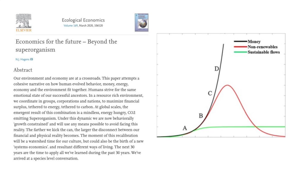
Here’s the abstract:
Our environment and economy are at a crossroads. This paper attempts a cohesive narrative on how human evolved behavior, money, energy, economy and the environment fit together. Humans strive for the same emotional state of our successful ancestors. In a resource rich environment, we coordinate in groups, corporations and nations, to maximize financial surplus, tethered to energy, tethered to carbon. At global scales, the emergent result of this combination is a mindless, energy hungry, CO2 emitting Superorganism. Under this dynamic we are now behaviorally ‘growth constrained’ and will use any means possible to avoid facing this reality. The farther we kick the can, the larger the disconnect between our financial and physical reality becomes. The moment of this recalibration will be a watershed time for our culture, but could also be the birth of a new ‘systems economics’. and resultant different ways of living. The next 30 years are the time to apply all we’ve learned during the past 30 years. We’ve arrived at a species level conversation.
“Ecological Economics addresses the relationships between ecosystems and economic systems in the broadest sense.” – Robert Costanza, (the first sentence in the first article in the first issue of Ecological Economics)
“The real problem of humanity is the following: we have paleolithic emotions; medieval institutions; and god-like technology.”– E.O. Wilson
“We live in a world where there is more and more information, and less and less meaning.” –Jean Baudrillard
“Not everything that is faced can be changed, but nothing can be changed until it is faced.” – James Baldwin

My final Earth Notes of the year aired recently. Click on the photo below to hear the story. You can also read more about Hopi Trails by continuing below. “Earth Notes” is produced by KNAU and the Sustainable Communities Program of Northern Arizona University. In 2007 I worked with the Village of Sipaulovi (2nd Mesa) […]
Earth Notes: Hopi Trails in the Southwest — PAA’TUUWI

“One of the big problems with bringing water from somewhere else is a false sense of security. When we live long distances from our water, we may not understand the limits of that supply or ecosystem- so conservation is less likely” — Abby Burk
Reprinted with permisssion from Don Siefkes:
Mike Wade, “Imperial Valley can’t sustain another water cut,” Dec. 14, is absolutely right. However, if we can’t get new water to the Colorado River, and even though conservation is important, no amount of conservation is going to fix this problem.
Here’s one solution to avoid the looming disaster. The National Infrastructure Bank (NIB) set out in House Resolution 3339 would provide $5 trillion in low-cost loans for a broad range of public infrastructure projects – including massive water systems – without the need for increasing taxes or any deficit budget spending. This bill is modeled on the successful Reconstruction Finance Corporation (RFC) started by President Herbert Hoover and used by President Franklin D. Roosevelt to build Hoover Dam and bring water and electricity to the Southwest.

The NIB is prepared to invest up to $400 billion to bring new water to the Colorado River and the Southwest. One possibility would be to divert water from the Atchafalaya River in Louisiana through Louisiana, Texas, New Mexico, Arizona and up to the Glen Canyon Dam.
In this proposal, no water would be taken from the main channel of the Mississippi. As of Dec. 19, 1.43 million gals/sec of Atchafalaya River water was simply going into the Gulf of Mexico without producing electricity or supporting commercial shipping. Taking just 100,000 gals/sec (7%) of this water would fill Lakes Powell and Mead to 50% capacity in one year and 9 months. The project would save on construction costs by using an existing facility – the Old River Control Complex just south of Vidalia, Louisiana, where the Army Corps of Engineers diverts 30% of the downflow of the Mississippi to prevent flooding in New Orleans.
This undertaking would build a 1,400 mile series of pipelines, open channels, tunnels and pumping stations (similar to the California, Los Angeles, Colorado River Aqueducts and the Central Arizona Project). It could be built in a year, along interstate highway rights-of-way, using huge earth-moving machines like those employed in Holland for their canal systems.
There is historical precedent for building systems like this project with deliberate, urgent, speed. In less than a year between 1942 and 1943, the RFC financed and built two pipelines of similar length, 1,200 and 1,400 miles, to carry crude oil from Texas oil fields to the East Coast. These pipelines rescued the entire East Coast industrial oil refining system and won World War II for the Allies.
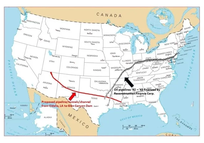
Such a water aqueduct system might cost on the order of $14 billion-23 billion, a small amount for a $5 trillion bank and also small compared to cutting off water supplies to farmers in the Southwest who produce $39 billion worth of our annual food supply. Without new water in the Colorado, food prices will skyrocket more than they already have, and we will all needlessly suffer. It is also unthinkable to allow water levels in Lakes Mead and Powell to fall to the point where the dams can no longer generate electricity or provide drinking water.
We don’t think anything about pumping crude oil and gasoline through 190,000 miles of U.S. pipelines from areas that have oil and gasoline to areas that don’t. We certainly can do the same with water.
All U.S. senators and representatives, regardless of party, should get behind HR 3339 and vote for the National Infrastructure Bank.
Alphecca Muttardy is a Macroeconomist with the Coalition for a National Infrastructure Bank (NIBCoalition.com), and 25 year veteran of the International Monetary Fund. Don Siefkes is an MIT-trained chemical engineer who represents the Coalition for the NIB in the San Francisco Bay Area. Their emails are, respectively, amuttardy@gmail.com and donsiefkes@aol.com.

Click the link to access the article on the MDPI website (Fred D Tillman, Natalie K. Day, Matthew P. Miller, Olivia L. Miller, Christine A. Rumsey, Daniel R. Wise, Patrick C. Longley, Morgan C. McDonnell). Here’s the abstract:
The Colorado River is a critical water resource in the southwestern United States, supplying drinking water for 40 million people in the region and water for irrigation of 2.2 million hectares of land. Extended drought in the Upper Colorado River Basin (UCOL) and the prospect of a warmer climate in the future pose water availability challenges for those charged with managing the river. Limited water availability in the future also may negatively affect aquatic ecosystems and wildlife that depend upon them. Water availability components of special importance in the UCOL include streamflow, salinity in groundwater and surface water, groundwater levels and storage, and the role of snow in the UCOL water cycle. This manuscript provides a review of current “state of the science” for these UCOL water availability components with a focus on identifying gaps in data, modeling, and trends in the basin. Trends provide context for evaluations of current conditions and motivation for further investigation and modeling, models allow for investigation of processes and projections of future water availability, and data support both efforts. Information summarized in this manuscript will be valuable in planning integrated assessments of water availability in the UCOL.
Click the link to read the article on the Associated Press website (Sam Metz). Here’s an excerpt:
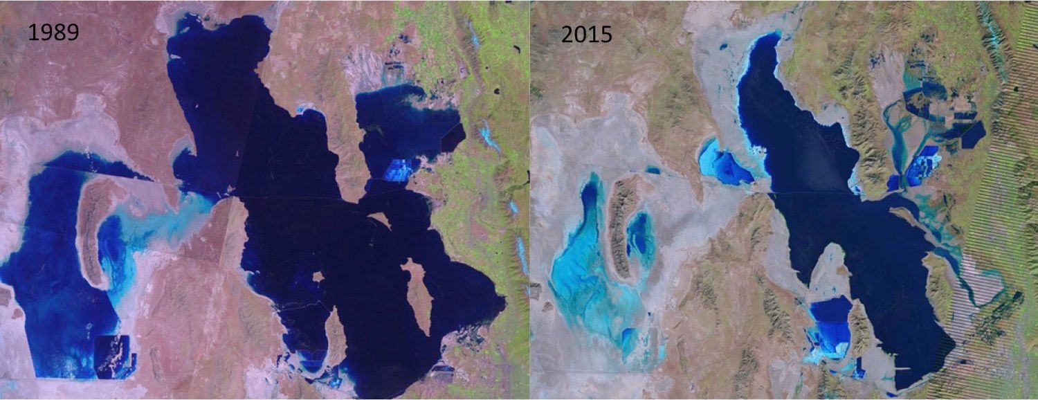
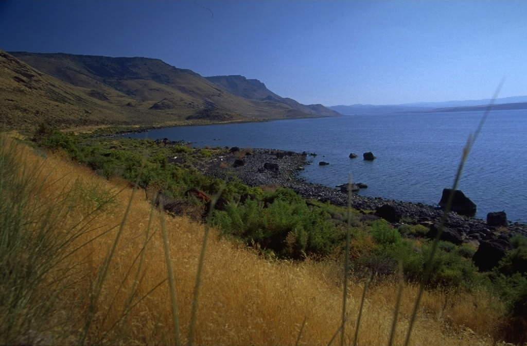
Scientists will get $25 million to study salt lake ecosystems in the drought-stricken U.S. West, as President Joe Biden signed legislation Tuesday allocating the funds in the face of unprecedented existential threats caused by the lack of water.
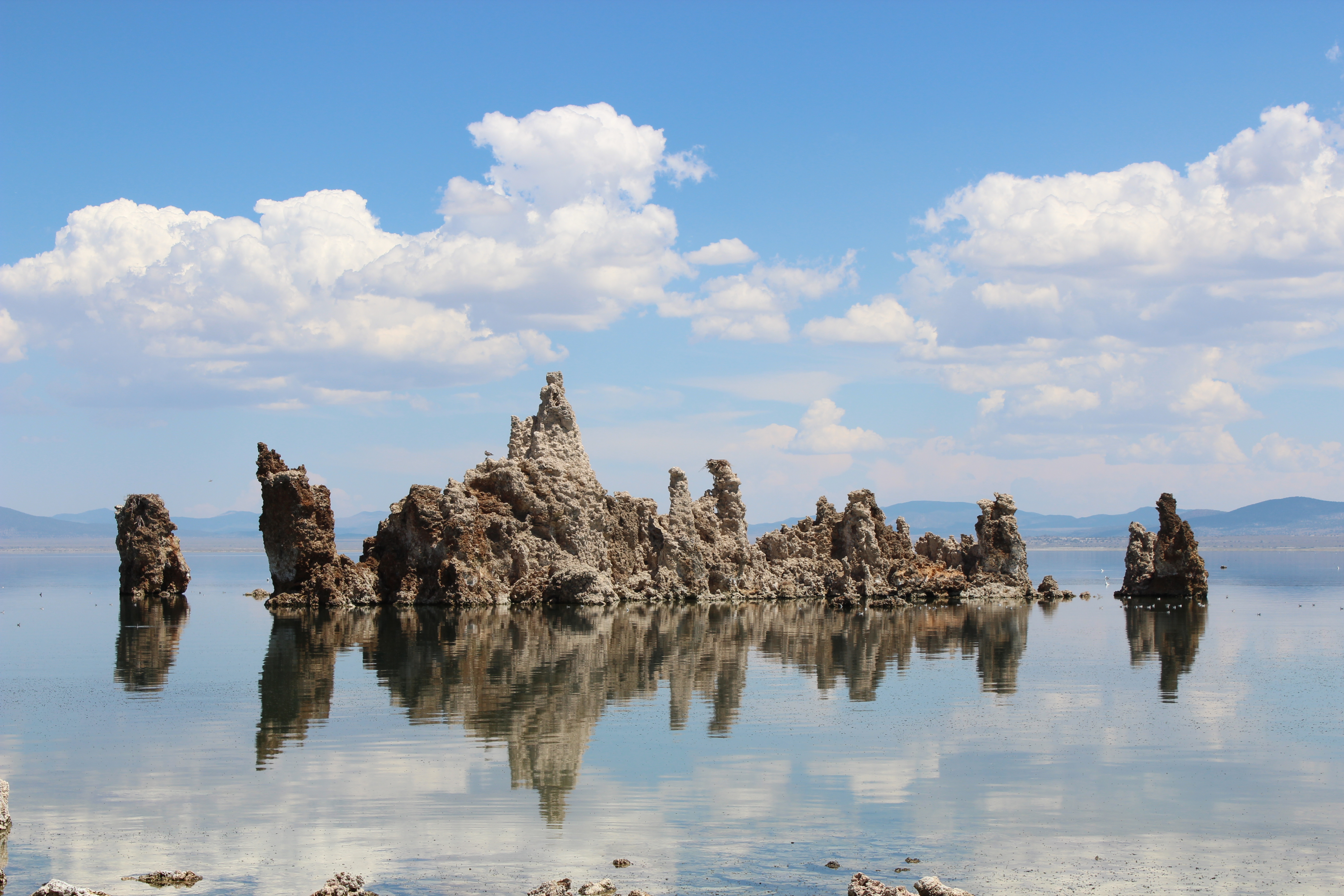
The funding allows the United States Geological Survey to study the hydrology of the ecosystems in and around Utah’s Great Salt Lake, California’s Mono Lake, Oregon’s Lake Albert and other saline lakes.

Amid a decadeslong drought, less snowmelt has flowed through the rivers that feed into the lakes, causing shorelines to recede and lake levels to plummet. Dwindling lake levels jeopardize the people, animals and businesses that rely on maintaining the ecosystem. The lakes often serve as critical habitats for migratory birds. Dust exposed by receding water levels can be blown into the air and have dangerous health effects on surrounding communities. And further depletion threatens the canals and infrastructure that a multi-million dollar mining industry needs to extract salts from the lakes…
In Utah, the Great Salt Lake shrunk to its lowest point in recorded history, posing threats to economic output, snowpack, public health and wildlife…In eastern California, state officials have dramatically curtailed the amount Los Angeles can divert from the creeks and tributaries that feed Mono Lake in the eastern Sierras…
Marcelle Shoop, the Saline Lakes Program Director for the Audubon Society, said in a statement that the funding would complement existing conservation efforts. “The Great Salt Lake and the network of saline lake ecosystems in the arid West face very serious challenges with increasingly low water levels, placing local communities and millions of migratory birds at risk,” she said…The bill adds to $40 million that Utah lawmakers allocated to the Great Salt Lake for watershed enhancement programs this year and supplements $10 million in Army Corps of Engineers funding for the saline lakes passed as part of a defense spending bill.

From the latest newsletter from Northern Water:
Colorado Parks and Wildlife officers have detected the presence of a nonnative invasive plant species in Boulder Reservoir.
The plant, Eurasian watermilfoil (EWM), was detected during a routine inspection at the reservoir in the summer of 2022 and confirmed during a follow-up survey in the fall. The plant is established primarily along the western coves of the reservoir and in areas along the southern and northern shorelines, according to a release from the City of Boulder. It is not harmful to public health and at its current growth levels, there are no impacts to recreation use at the reservoir or its use as a municipal and irrigation supply.
If the growth becomes very dense, the plant could impact swimming and boating and cause taste and odor issues with drinking water.
“While the survey confirmed the presence of EWM at the reservoir, we don’t know how it arrived. It can easily be transported by wind, connected waterways, humans fishing, dogs, watercraft, or wildlife, so we encourage anyone who recreates in the water to be vigilant about checking for aquatic nuisance species,” said Boulder Parks and Recreation Director Ali Rhodes. “The survey did find that there are no other aquatic nuisance or invasive plant species in the reservoir, which is good news.”
According to the city, recreation users will see a continuation of changes put in place in summer 2022. Upon initial detection of the plant, the city adjusted operations to include exit inspections on watercraft, increased education to users and added notification signage.

Patrick Omeja, Makerere University; Abay Yimere, Tufts University; Desta Mebratu, Stellenbosch University, and Jennifer Fitchett, University of the Witwatersrand
Can our planet recover from climate change? Commissioning Editor, Kofoworola Belo-Osagie, asked scientists to share the reasons they believe there is hope.
Jennifer Fitchett, Associate Professor of Physical Geography, School of Geography, Archaeology and Environmental Studies, University of the Witwatersrand, South Africa
People are starting to notice the weather and climate, and to understand climate change better than ever before.
It is very difficult for humans to feel the 1.1℃ post-industrial warming. In Johannesburg, our diurnal temperature range is often more than 20℃. From day to day our maximum temperatures can differ by over 10℃. This makes climate change seem intangible. However, over the last few years, the public has become far more aware of the weather and climate, and the impacts of climate change are becoming more tangible, more easily observed, and more measurable by the person on the street.
We are noticing, for example, that jacarandas are flowering earlier than they used to. We are aware that floods are evidence of extreme climates, and that extreme climate events are affecting southern Africa more frequently than they used to.
The tone of public discourse is starting to shift. Sometimes this leads to single events not-quite-correctly being attributed to climate change. But it shows that people are aware and concerned about their climate future. This public awareness is a crucial first step in addressing climate change.
While is it very important to recognise the immense value of young climate change activists like Greta Thunberg, we often don’t notice the many students across the world who are choosing to pursue degrees in fields relating to climate change. The University of the Witwatersrand launched a short course that was offered to over 5,000 incoming first year students in 2022, and which was taught by a PhD student in climate change. This large cohort of students passionate about understanding climate science, avenues for adaptation, and innovations for mitigation is our future!
Patrick Omeja, Senior Research Fellow, College of Agriculture and Environment, Makerere University, Uganda
There is an urgent need for far-reaching change. Government action on climate change is slow as their hands are often tied by stringent bureaucracy, big business and the need to please all of the electorate.
However, I am optimistic that climate action will happen because communities, businesses and foundations around the world are seeing the need for action and doing their part.
For example, in Uganda, solar panels are appearing everywhere. Large companies like Coca-Cola Africa, Nile Breweries, Unilever and Nations Media Group are supporting efforts to restore natural ecosystems and putting the environment before profits. And, for example, the Ivey Foundation in Canada is liquidating its entire endowment to promote climate action now. The funding from these companies is supporting many innovations and solutions, from refugee communities creating forests in the deserts to innovators turning plastics into boats and building materials. They are finding ways to save energy and reduce the footprints of carbon emissions.
Africa is just awash with new ideas and initiatives that are turning environmental challenges into new sources of livelihoods, and adapting to and mitigating the impacts of a changing climate. If many small groups take action, it will make a real difference.
Generally, if humans are the primary cause of a globally warming climate, that means we can also be the architects of its undoing. I think people know that action needs to urgently happen, so people from all walks of life will volunteer to help. I believe human nature “overall” is good and the degraded ecosystems are resilient to recovery, given time and support.
Desta Mebratu, Professor, Centre for Sustainability Transitions, Stellenbosch University, South Africa; Fellow, African Academy of Science
The Paris Agreement on climate change, adopted in 2015, brought a new sense of optimism in terms of addressing the challenges associated with climate change. Unfortunately, the gap between pledges and commitments made by national governments and concrete actions on climate change continued to widen in the subsequent years. This has made the possibility of limiting the planetary temperature rise to 1.5℃ more remote.
Over the last couple of years, we have witnessed increased engagement and leadership of non-state actors, including businesses, civil societies and major groups such as youth groups and local communities. This has led to a plethora of initiatives and partnerships aimed at fast-tracking climate actions and has created a new sense of optimism.
This, coupled with the increasing motivation and creativity displayed by youth groups across the world around climate action, gives me a great sense of hope about our collective future.
Ultimately, however, it all depends on how fast national governments take concrete climate actions.
Yimere Abay, Research Fellow, Centre for International Environment and Resource Policy, Tufts University, United States
The sixth assessment report of the Intergovernmental Panel on Climate Change, published in 2022, described a gloomy future for life on planet Earth. The report detailed the irreversible impacts of change on ecosystems, human life and biodiversity, along with disproportionate impacts across regions, sectors and communities. It called for urgent decisions by world leaders to minimise the adverse consequences. Disappointingly, the 27th Conference of Parties (COP27) of the United Nations Framework Convention on Climate Change didn’t agree to phase down all fossil fuels.
Yet there are still reasons to be hopeful for progress from COP.
First, the cost of wind and solar technologies is plummeting. Technologies for carbon capture, utilisation, storage and transmission are rapidly progressing to foster transformation into a low-carbon market. Africa has an opportunity to use its massive renewable energy resources, harness its minerals and metal resources to develop solar photovoltaic systems and wind turbines, and address the barriers in the way of clean energy development. The turning point will be when fossil fuels become less efficient and more expensive than renewables.
COP27 called for reforms in multilateral development banks. Reforms could address Africa’s reputation of being “riskier” for climate investment by providing guarantees. Africa needs US$2.8 trillion from 2020 to 2030, whereas the yearly climate finance flow is only US$30 billion.
COP27 also introduced a new holistic approach towards food and agriculture. The aim is to boost the finance for agricultural transformation and adaptation. This is another reason to be optimistic, since about 70% of the continent’s population depends on agriculture.
Finally, it’s encouraging to see social movements, particularly among the youth, taking action on climate change. These social movements, including indigenous peoples’ alliances, have self-organised across all regions without discrimination of faith, race, colour, age, gender, ideology, or education and have become the guardians of the future.
Patrick Omeja, Senior Research Fellow and Field Manager, Makerere University Biological Field Station, Makerere University; Abay Yimere, Postdoctoral Scholar in International Environment and Resource Policy, Tufts University; Desta Mebratu, Professor and United Nations High Level Champions (UNHLC) Lead on Waste, Stellenbosch University, and Jennifer Fitchett, Associate Professor of Physical Geography, University of the Witwatersrand
This article is republished from The Conversation under a Creative Commons license. Read the original article.
Click the link to read the article on the WyoFile website (Angus M. Thuermer Jr.):
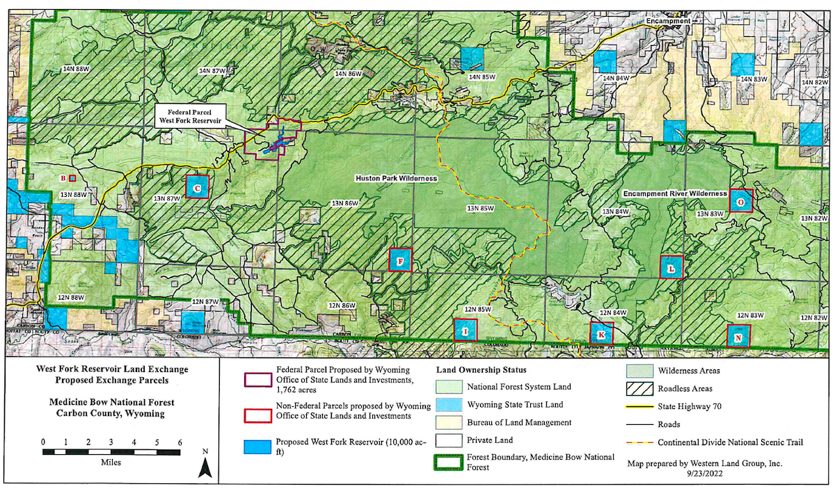
Wyoming moved to expedite the construction of a 280-foot-high concrete dam in the Medicine Bow National Forest last month by proposing a 6,282-acre land exchange.
The state wants 1,762 acres of federal property for a dam and reservoir on the West Fork of Battle Creek in the Sierra Madre Mountains, according to a Nov. 30 letter and map from Jenifer Scoggin, the director of Wyoming’s Office of State Lands and Investments. In exchange, Wyoming would transfer ownership of up to 4,520 acres of state school trust lands to the federal government. That school trust land lies inside the boundaries of the Medicine Bow-Routt National Forest.
The Medicine-Bow announced the application in a press release setting three public meetings that will be held on the evenings of Jan. 10, 11 and 12 in Craig, Colorado, Baggs and Saratoga respectively. The dam would be built on a tributary of the Little Snake River that flows into the Yampa, Green and Colorado Rivers.
“Conveying this parcel out of Federal ownership would eliminate the need for a USFS special use permit for the reservoir as well as provide for efficient management of the reservoir and surrounding lands,” states the 19-page notice of intent and proposal, which Scoggin sent to Brush Creek/Hayden District Ranger Jason Armbruster in Saratoga. Wyoming needs the federal property to construct the reservoir and meet “fiduciary obligations to produce income to support public schools and other state institutions,” the letter reads.
WyoFile obtained a copy of Scoggin’s letter, the proposal and map Tuesday from deputy director Jason Crowder.
The state Board of Land Commissioners last summer conceptually approved investigating a land exchange that would have covered some 24,000 acres. That approval allowed state officials to offer a smaller exchange in an effort to accelerate the West Fork Dam and reservoir project, Crowder said.
Smaller would be faster
“[T]he reality of getting something like that [larger exchange] done isn’t all that hot,” Crowder said. The Forest Service would have to examine a larger exchange through the National Environmental Policy Act process, which would take considerably longer than what’s being proposed, he said.
“Something that large isn’t anything that could get done in a timely fashion,” Crowder said. “It’s probable that a larger exchange … wouldn’t be feasible or successful in the near term.”
Instead, an exchange “that was more narrowly focused [on the land] needed for the reservoir construction and implementation would be OK,” he said.
Instead of writing an environmental impact statement that’s common for major proposals under NEPA, the Forest Service will instead conduct a “feasibility analysis/study,” Medicine Bow officials said in a statement. “The resulting product is referred to as a Public Interest Determination,” that would approve or reject the exchange, the Forest Service news release states.
The Forest Service study will focus on the future use and management of the lands and the effect of the exchange on the lands that adjoin them, the Medicine Bow release said.
Estimated in 2017 to cost $80 million, the proposed West Fork Reservoir would serve 67 to 100 irrigators. A 130-acre reservoir would hold 10,000 acre feet of water primarily for irrigation. The project is sponsored by: Savery-Little Snake Conservancy District and Pothook Conservancy in Colorado, the Forest Service said.
The proposed reservoir would impound and divert water from the troubled Colorado River Basin where residents in seven states and Mexico are at odds over how to use dwindling flows.
“It is important to note that the Forest Service has not yet determined if this is a feasible exchange, nor has the agency agreed to initiate it,” the Medicine Bow statement reads.
The Jan. 10 meeting in Craig will be from 5-7 p.m. at Colorado Northwest Community College. A virtual option will be available through the Forest Service website.
The meeting Jan. 11 in Baggs will be held from 6:30-8:30 p.m. at the Valley Community Center. The Saratoga meeting the following day will be from 5:30-7:30 at the Platte Valley Community Center.Land exchange proposal details will be available the week of the public meetings on the Forest’s project website, the Medicine Bow announcement stated.

Click on a thumbnail graphic to view a gallery of drought data from the US Drought Monitor website.
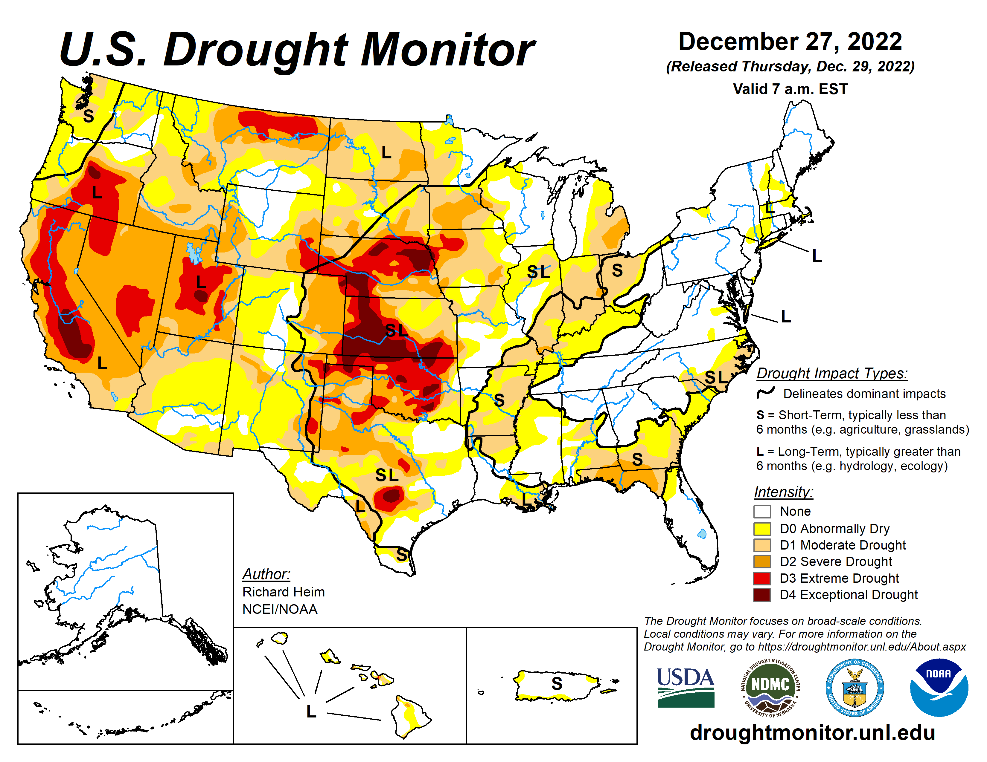

Click the link to go to the US Drought Monitor website. Here’s an excerpt:
This Week’s Drought Summary
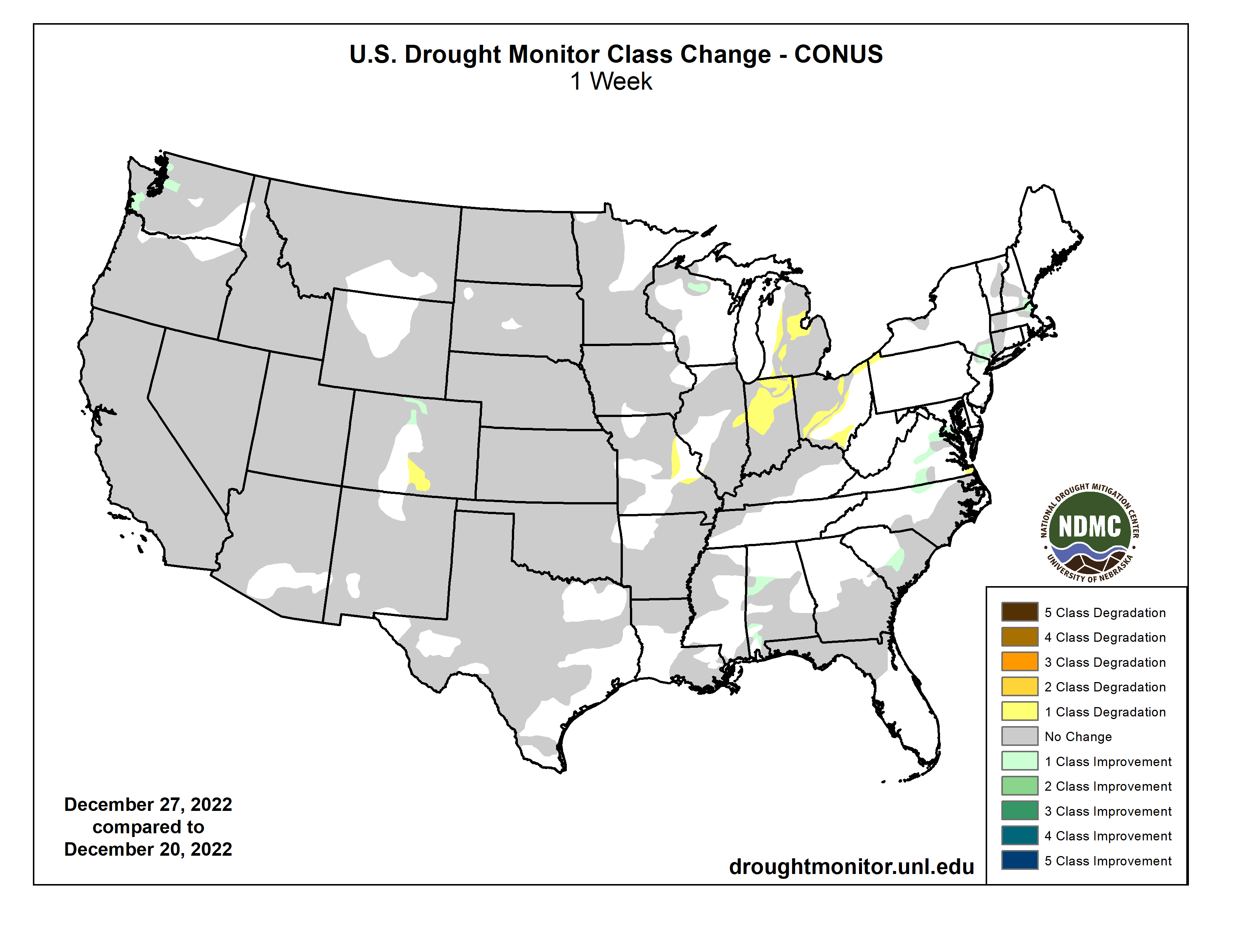
A powerful low-pressure trough developed in the upper levels of the atmosphere over the eastern contiguous U.S. (CONUS) during this U.S. Drought Monitor (USDM) week (December 21-27). At the surface, the trough was associated with a strong cold front that poured frigid arctic air into the U.S. east of the Rockies. Daytime maximum temperatures in the northern Plains were well below zero degrees Fahrenheit, with minimum temperatures colder than 20 below zero, at the peak of the cold wave. Bismarck, North Dakota, registered minus 10 for a high and minus 20 for a low on December 21 and 22; the high was below zero for 4 consecutive days and below freezing for at least 2 consecutive weeks. Williston, North Dakota, recorded minus 17 for a high and minus 29 for a low on December 20. The freezing arctic air spread to the Gulf of Mexico and East coasts, and even breeched the Rocky Mountain chain to reach the Pacific Northwest. The high temperature at Tupelo, Mississippi, was only 18 degrees with a low of 4 on December 23. Rain, freezing rain, and snow accompanied the arctic front as it swept east and south. An inch or more of precipitation fell across parts of the Gulf Coast and from the Appalachians to East Coast when the front tapped Gulf and Atlantic moisture. Some parts of the Mid-Atlantic and Northeast states received over 2 inches of precipitation, while an inch or more occurred over the lee sides of the Great Lakes, largely in the form of heavy lake effect snow. Buffalo, New York, officially measured 50.3 inches of snow from December 23-26, but much more snow fell in other favored leeside areas. Locally up to half an inch of precipitation occurred from the northern Plains to Upper Mississippi Valley. But the northwesterly flow was otherwise dry, so large parts of the Great Plains, Mississippi Valley, and Ohio Valley to Gulf Coast received less than half an inch of precipitation to no precipitation. The arctic blast froze soils across much of the Great Plains to Upper Mississippi Valley. Any precipitation that fell was not able to penetrate the frozen ground to increase soil moisture, so much of this region had no change in USDM status. In reaction to the eastern trough, an upper-level ridge developed over the western CONUS. This kept weekly temperatures near to warmer than normal from California to the Four Corners states, but it also kept much of the West dry. The exception was northern California to the Pacific Northwest and parts of the central and northern Rockies, where Pacific fronts brought areas of rain and snow. Two inches or more of precipitation fell in coastal areas and in the northern Rockies, with up to ten inches in parts of western Washington. Meanwhile Hawaii and Puerto Rico had a mostly drier-than-normal week while drier- and colder-than-normal weather dominated Alaska. The deep freeze and dry weather resulted in status quo conditions for much of the country. Drought or abnormal dryness expanded in parts of the Midwest, Colorado, and Puerto Rico, while contraction occurred in a few areas in the Southeast, East Coast, Wisconsin, Colorado, and Washington…
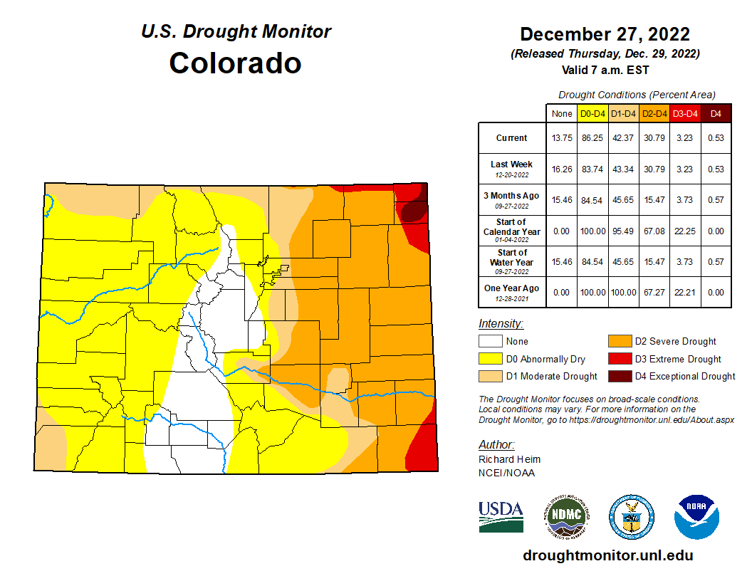
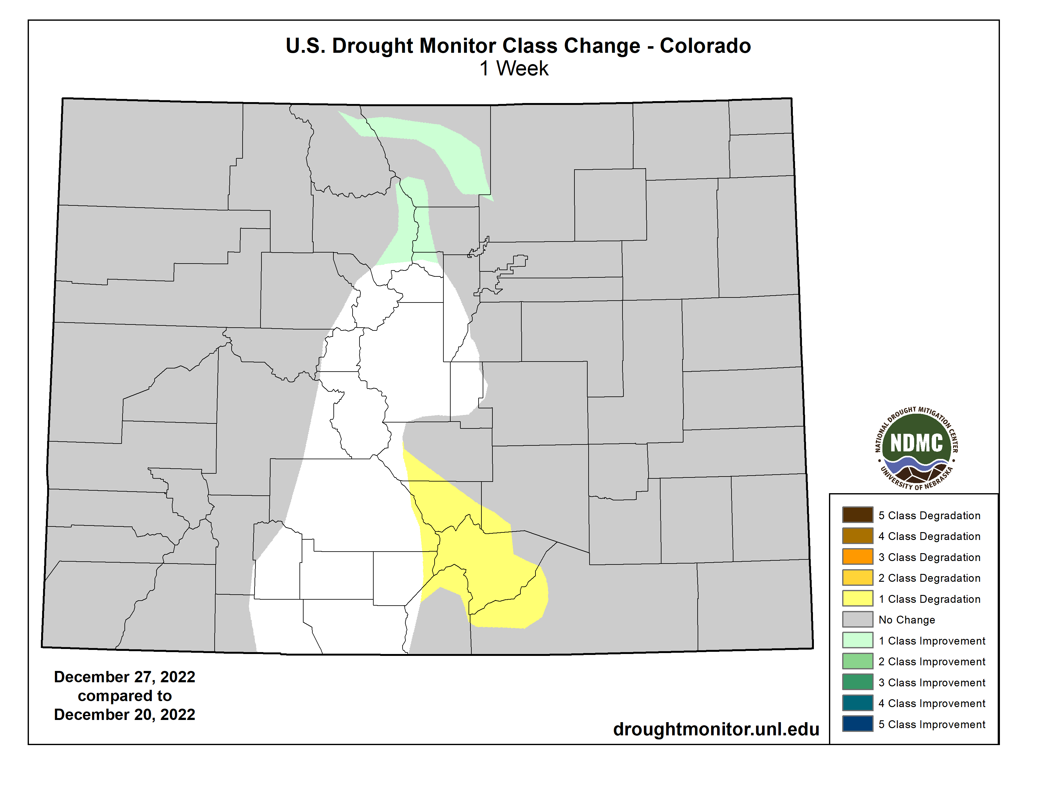
High Plains
Most of the High Plains region received less than half an inch of precipitation. Pockets of half to 1 inch of precipitation were found over North Dakota and the mountains of Colorado and Wyoming. The precipitation was above normal in parts of all of the High Plains states, but late December is in the dry season for much of the region and normals are low. With the entire region experiencing a deep freeze this week, little change was made to the USDM depiction. The exception was Colorado, where D0 expanded in south central counties due to low snowpack and 1- to 4-month precipitation deficits, and D0-D1 contracted in north central counties based on precipitation surpluses at the 1-week to 3-month time scales…
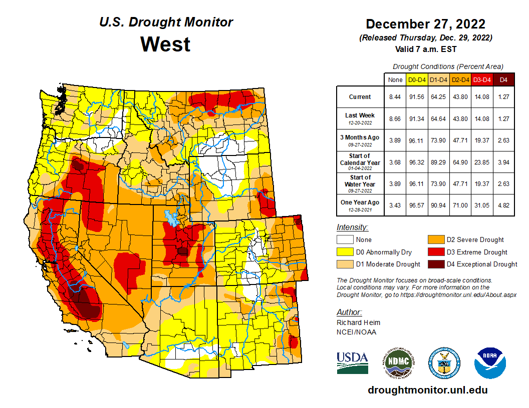
West
Pacific frontal systems brought rain and snow to coastal areas of the West, from northern California to Washington, and to parts of the Rockies. Two to 5 inches of precipitation fell along the coastal and Cascade ranges, with up to 10 inches locally in Washington. Amounts ranged up to 2 inches or more in the northern Rockies. Pockets of up to 1 inch of precipitation were found over the central Rockies, but for the states further south, southern California, and the intermountain basin, little to no precipitation occurred. Since this is the wet season in the Pacific Northwest, the heavy precipitation this week resulted in month-to-date totals that were barely above normal in some areas, and 3-month precipitation totals were still below normal across most of the Pacific Northwest. Very dry SPI values were still evident at the 6-month time scale in spite of this week’s precipitation. Soils were saturated and real-time and 7-day stream levels rose significantly in response to the rain, but 28-day streamflow levels, which are more relevant for drought monitoring, were still very low as of the Tuesday morning valid date of this USDM. Snow depth increased at some sites in northern Washington and the Idaho to Colorado mountains, but most locations in the Pacific Northwest experienced no change or a decrease in snow depth. Reservoirs in Oregon continued very low across the state, with some of the large reservoirs (e.g., Owyhee, Warm Springs, Prineville, Howard Prairie) less than 15% full. Most of the reservoirs across the Pacific Northwest saw very little change in reservoir levels since the beginning of the month. D1 was pulled back in those parts of Washington that had the heaviest precipitation and reflected improvement at 1- to 3-month time scales, but most of the D1 and the D0 were kept in place across the Pacific Northwest to reflect the aggregate indicators and conditions at all time scales. The bulk of the precipitation that fell in California occurred near the end of the USDM week. This precipitation, and the precipitation that followed after the Tuesday morning valid time, will be evaluated in next week’s USDM. No change was made to the rest of the West region outside of Washington…
South
This week was drier than normal across all of the South region. Around half an inch of rain fell over parts of southern Mississippi and southeast Louisiana. Otherwise, weekly precipitation totals were less than a tenth of an inch, with large parts of Texas and Oklahoma receiving no precipitation. Much of the region has been wet during the last 2 months, but dry conditions dominate at longer time scales. The cold and dry conditions this week locked moisture conditions in place, so no change was made to the USDM depiction in the South…
Looking Ahead
As the cold air mass over the eastern CONUS exited out of the country during December 27-29, a strong Pacific weather system moved into the West, bringing abundant rain and snow. The western weather system will move across the West and into the central part of the country, while an upper-level ridge shifts eastward to dominate the weather over the East Coast. This combination will result in warmer-than-normal temperatures for much of the CONUS, especially east of the Rockies, and wet conditions from the Lower Mississippi Valley to eastern Great Lakes. The Pacific system will spread several inches of precipitation across much of the West, with 1 to 4 inches already having fallen through December 28. Predicted precipitation amounts for December 29-January 3 range from 1 to 4 inches over the Rockies and higher terrain of the intermountain basin, and from 4 to 10 inches or more along the immediate Pacific Coast, especially in California and the Sierra Nevada. As the weather system moves further east, 1 to 4 inches of precipitation is expected from east Texas to the Mid-Mississippi Valley and in the Southeast. One to 2 inches of precipitation is predicted across the central Plains to Upper Mississippi Valley, across parts of the Great Lakes, and into New England, with half an inch to an inch across the rest of the CONUS east of the Mississippi River. For January 4-10, the ridge over the eastern half of the CONUS is expected continue, keeping most of the country east of the Rockies warmer than normal, while the West averages near to cooler than normal. Odds favor above-normal precipitation across most of the CONUS, with near to below normal precipitation favored for parts of the northern and southern Plains. Drier-than-normal weather with near-normal temperatures are expected for northern Alaska, and wetter and warmer than normal for southern Alaska.
Click the link to read the article on The Salt Lake Tribune website (Brian Maffly). Here’s an excerpt:
Nevada water managers have submitted a plan for cutting diversions by 500,000 acre-feet in a last-ditch effort to shore up flows on the Colorado River before low water levels cause critical problems at Glen Canyon and Hoover dams. But the Silver State’s plan targets cuts in Utah and the river’s other Upper Basin states, not in Nevada, whose leaders contend it already is doing what it can to reduce reliance on the depleted river system that provides water to 40 million in the West.
“It is well past time to prohibit the inefficient delivery, application, or use of water within all sectors and by all users; there simply is no water in the Colorado River System left to waste and each industrial, municipal, and agricultural user should be held to the highest industry standards in handling, using, and disposing of water,” states a Dec. 20 letter the Colorado River Commission of Nevada sent to the Interior Department. “It is critical that Reclamation pursue all options that will help reduce consumptive uses in the Basin and provide water supply reliability.”
[,,,]
One option Nevada offers is for Utah, Colorado, New Mexico and Wyoming to accept substantial cuts in the amount of river they tap to ensure enough water reaches Lake Powell to keep Glen Canyon Dam’s hydropower turbines spinning and Lake Powell functioning as a reservoir…The proposal comes in the form of Nevada’s official comments to the supplemental environmental impact statement the Bureau of Reclamation is preparing for proposed changes to the operations of the drought-depleted reservoirs. One of three Lower Basin states, Nevada called on the Upper Basin states to reduce their withdrawals by a combined 500,000 acre-feet if Lake Powell’s level is projected to drop below 3,550 feet above sea level at the start of the coming calendar year…Today, the lake’s level is already far below than that, at 3,525.7 feet, just 35 feet above the point at which Glen Canyon Dam’s turbines would be damaged if water passes through the penstocks.

“The reason [The Upper Colorado River Commision’s] five-point plan doesn’t have any specific numbers is because we don’t know what’s ahead of us. We don’t know whether the runoff is going to be 7 million acre-feet or 20 million acre-feet,” Shawcroft said. “The real challenge is the hydrology. But we know for a fact that that we’re not going to be able to continue operating the river like we always have. The majority of the water gets used in the lower basin states, but does that mean that Upper [Basin] states are off the hook? I don’t think they are.”
Click the link to read the article on the Water Education Colorado website (Jerd Smith):
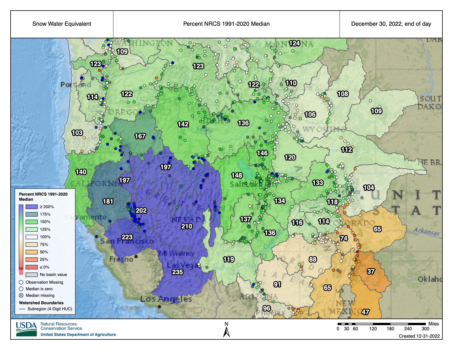
Last week’s snow gave Colorado holiday skiers plenty to rejoice over, but the state’s drought-hammered mountains and plains continue to see just average, and in some cases far below average, conditions.
“An average snow year is a whole heck of a lot of snow, even in a year when we’re below average. It’s a great year for skiing but it may or may not translate into a great year for water,” said Russ Schumacher, Colorado’s state climatologist.
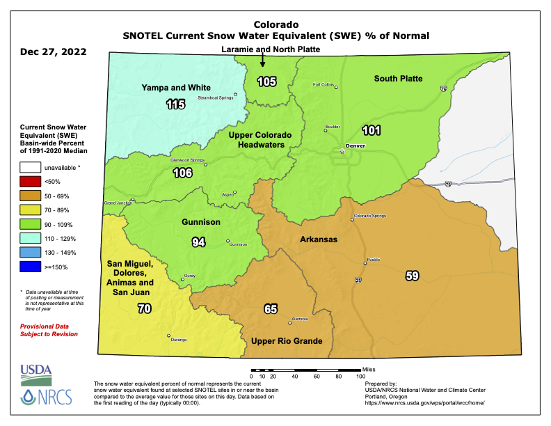
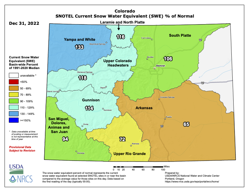
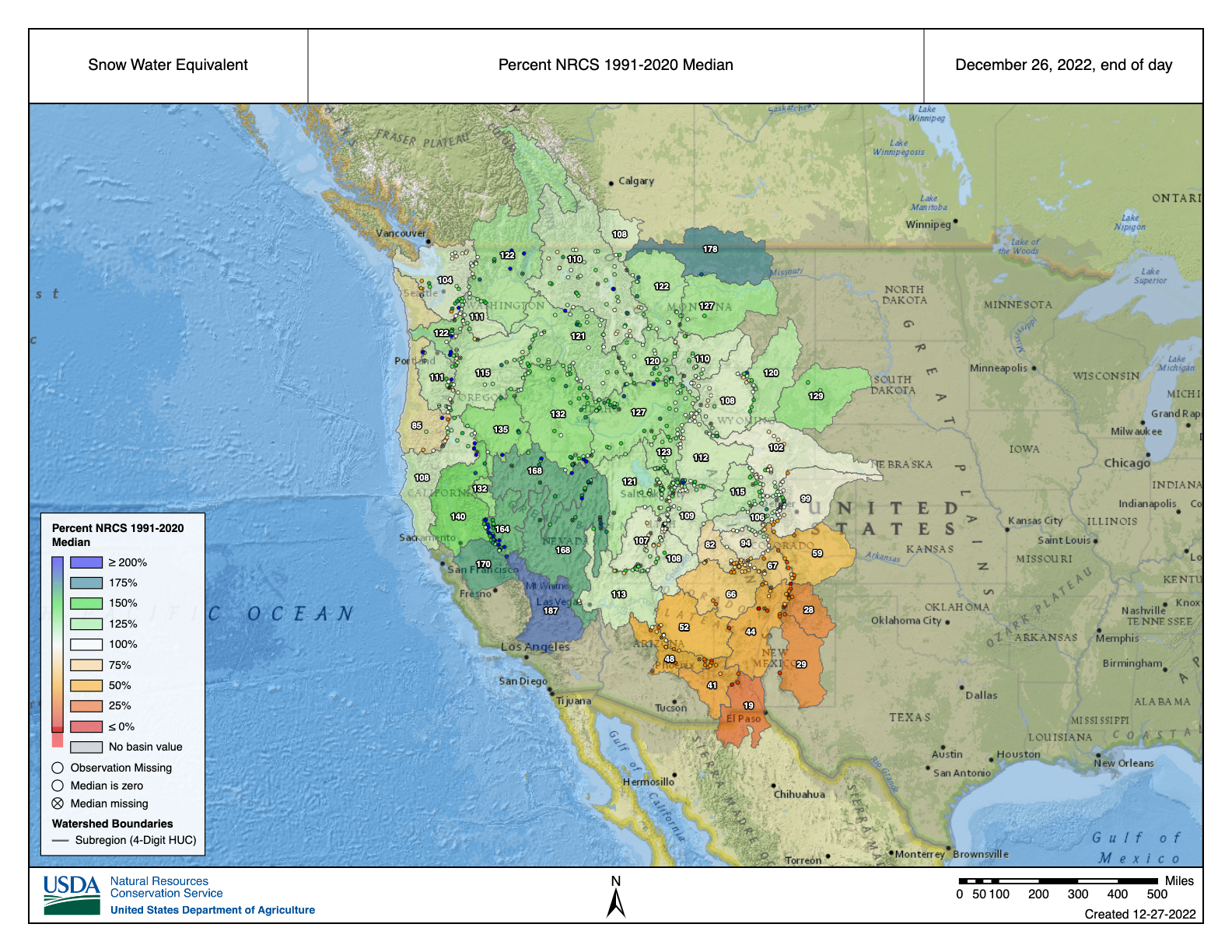
As of Dec. 27, the statewide snowpack is registering at 102% of normal, according to the Natural Resources Conservation Service (NRCS).
And while that number doesn’t provoke much excitement among hydrologists, it is still substantially higher than it was at this time last year, when statewide snowpack was just 74% of normal, according to Karl Wetlaufer, a hydrologist and assistant snow survey supervisor at the NRCS in Lakewood.
Mountain snow levels are tracked closely because when they melt, they provide much of the state’s annual water supplies. Hydrologists, using a time period known as the water year that begins Oct. 1, begin monitoring with the first snows in the late fall, and continue through May 1 when the spring melt and runoff begin. Spring snowstorms can sometimes dramatically boost the water forecast, though there is not much hope for that this year.
Colorado and much of the American West remain mired in a devastating drought, thought to be the worst in 1,200 years. But thanks to a third year of what’s known as a La Niña weather pattern, in which warm temperatures in the Pacific bring heavy moisture over the northern parts of the Rockies, Colorado’s northern regions are seeing above average snowpacks.
“In general, Northern Colorado has been faring quite a bit better with regard to snowpack accumulation than the southern parts of the state,” Wetlaufer said.
The Yampa River Basin, home to Steamboat Springs, and the neighboring White River Basin have the healthiest snowpacks right now, registering at 115% percent of average, with the South Platte Basin, home to Denver, Greeley and Fort Collins, registering 101%.
And as has been the case for the last several years, the southern part of the state is suffering the most.
The Rio Grande Basin, for instance, is at just 65% of normal, while the San Miguel-Dolores Basin stands at 70% of normal. The Arkansas River Basin is the lowest of anywhere in the state, at 59%.
Meanwhile, the Colorado River Basin, the heart of the giant seven-state system that is on the brink of collapse, is at 106% of normal, while the Gunnison River Basin, a major tributary to the Colorado, is at 94% of normal, according to the NRCS. The Yampa, White and San Miguel-Dolores basins also feed into the Colorado River system, but farther downstream and beyond Colorado’s borders.
With the winter off to a just-okay start, there is some good news. This past summer’s monsoons helped boost soil moisture levels to their highest point in eight years, and that means as snows start to melt next spring more of the water should find its way into streams and reservoirs, rather than being absorbed by the ultra-dry soils that have become a hallmark of this drought.
“It is really, really encouraging that we are going into the season with substantially more soil moisture,” Wetlaufer said.

In addition, the U.S. Drought Monitor shows that much of Colorado is pulling out of the most severe stages of drought, with portions of the central mountains being completely free of drought, and the West Slope and Front Range showing just abnormally dry to moderate drought levels. Drought ranging from severe to exceptional still remains across most of the Eastern Plains.
The warming climate and the stubborn drought continue to keep hydrologists and weather watchers on high alert.
The Colorado River’s two giant reservoirs, lakes Powell and Mead, are at critical lows and even an average snowpack this year isn’t going to provide much help, Schumacher said.
“Here in Colorado our water is very much determined by how much snow we get in any individual winter,” said Schumacher. “But the situation in lakes Powell and Mead is that we need year after year of way above average snowpack and that does not appear to be the pattern that we are in.
“The way that weather and climate has been going in the last 20 years is not in our favor,” he said.
Jerd Smith is editor of Fresh Water News. She can be reached at 720-398-6474, via email at jerd@wateredco.org or @jerd_smith.
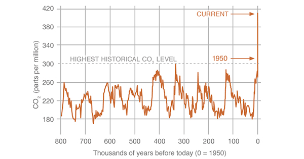
This is a roughly 50% increase since 1750 due to human activities, such as burning fossil fuels and land-use change

Click the link to read the article on the KJZZ websits (Ron Dungan). Here’s an excerpt:
Colorado River Basin states recently gathered in Las Vegas for their annual water users convention. The states are trying to figure out how to get by with less water. The conference focused on a variety of topics, such as new technology, conservation and funding that will guide water users into the next century. But federal water managers say that new conservation measures need to be put in place or they will impose cuts.
Click the link to read the latest edition of The Runoff newsletter from the Aspen Journalism website:
Cities versus agriculture
Some water managers at CRWUA acknowledged a truth that is widely known but rarely stated so candidly: As the Colorado River crisis deepens, water to cities will not be cut off in favor of continuing to grow hay in the desert, no matter what the law of the river — which grants the most powerful water rights to the mostly agricultural users who got here first — says.
“If the literal enforcement of the law is that 27 million Americans don’t have water, those laws will not be enforced,” said John Entsminger, general manager of the Southern Nevada Water Authority.
The wisdom of building mega-cities in arid regions aside, the fact is that Denver, Phoenix, Las Vegas and L.A. exist now and rely on the Colorado River. And denying people water at their taps would be a public health catastrophe and moral failure.
“People migrate toward opportunity and you can’t stop it only at great moral cost,” said Kathryn Sorenson, a professor at Arizona State University and former director of Phoenix Water Services. “The cities have an obligation to provide water to the people who arrived.”
Click the link to read the article on the Colorado Publie Radio website (Sam Brasch). Here’s an excerpt:
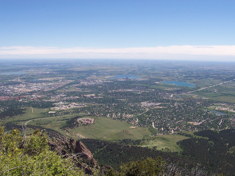
The setting of the 2021 disaster shocked Boulder County residents and scientists. While the original cause is still under investigation, the blaze got rolling in protected grasslands before hurricane-force winds rocketed it into suburban communities far outside the mountains…
“We’ve ignored grasslands in terms of fire risk. We’ve concentrated a lot on forests — and we need to really better understand the differences,” [Kathryn] Suding said.
One critical distinction is the resilience of deep-rooted grasslands. No burn scar is visible from Suding’s perch above the fire zone, proving how quickly fuels can return to prairie landscapes. In woodlands, by contrast, studies show thinning trees and removing low branches can reduce dangerous wildfire fuels for years. Suding said the challenge is even trickier due to climate change, which has brought drier summers and falls to the Front Range and packed areas with quick-burning thatch. She said the result is a “high window of risk that wasn’t there before.”
[…]
A year after the disaster, here are five ideas local governments in Boulder County are considering to guard against future grassfires.
1. Hardening homes
In November, Boulder County voters approved ballot issue 1A, which will raise $11 million annually to fund wildfire mitigation efforts. The money will expand Wildfire Partners, a program that previously helped mountain and foothills homeowners make their homes less vulnerable to fire…
2. Mowing
Other methods reduce fuel in natural landscapes rather than the built environment. That task is especially important in places where grasslands border homes, giving wildfires a clear and dangerous pathway into communities…
3. Grazing
Grazing is another method Boulder County communities already use to reduce grassland fuels. One question is whether it could be deployed even closer to suburban neighborhoods…
4. Landscape wetting
Through her research, Suding also plans to investigate plans to build stone structures across grassland drainages. The hope is that will help retain water, keeping plants wetter throughout the year and less vulnerable to fires…
5. Prescribed fire
The Front Range is no stranger to wildfires. Before Euro-American settlers brought a culture of fire suppression, North American prairies burned every two to 12 years, helping to reduce future fire risk and preserving rangeland for wildlife.
Click the link to read the article on the Colorado Newline website (Sara Wilson):
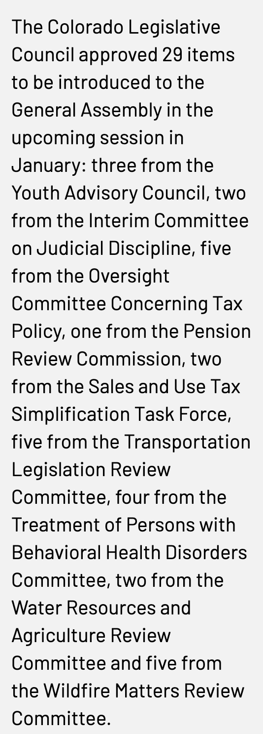
Colorado’s Joint Committee on Legislative Council has approved a slate of bills put forward by various interim committees to be introduced and considered in the next legislative session, ranging from a bill to create a new office for youth eating disorder prevention to one that would create a new task force to look into high altitude water storage.
The Legislative Council, which is made up of nine senators and seven representatives, is required to review bills put forward by the committees that meet outside of the legislative session. The bills they approve then get introduced in the session as a committee bill.
The council approved two items from the Interim Committee on Judicial Discipline, which was formed last legislative session in response to allegations of a quid pro quo to deter a former Judicial Branch chief of staff from going public with evidence of alleged misconduct.
“Senate Bill 22-201, which created this particular interim committee, did make some important changes in statute concerning flow of information about judicial discipline and, for the first time, codified independent funding for the commission. But statutory change alone did not and could not address the fundamentals of the system,” state Rep. Mike Weissman, an Aurora Democrat, said.
Both items passed out of the interim committee unanimously to be considered by the Legislative Council.
“These constitute meaningful and necessary changes to our judicial discipline process. They reflect all of us grappling hard with the 17 different points in our charge,” Weissman said.
One of the items from the interim committee, a concurrent resolution, would ask Colorado voters in 2024 to change some constitutional framework for judicial discipline. Primarily, it would make judicial discipline matters public and create an Independent Judicial Discipline Adjudicative Board that would replace the role of “special masters” in imposing sanctions.
The other item, a companion bill, fleshes out some of the details from the concurrent resolution.
Bills to address water storage, wildfire mitigation
The Legislative Council approved a bill from the Water Resources and Agriculture Review Committee that would create a task force to study the feasibility of high altitude water storage and whether snowmaking would result in meaningful storage. The task force would submit its report by June 2024.
The task force would focus on whether the idea could “augment water storage in a creative way,” Democratic state. Sen Kerry Donovan of Vail said. “That will be a very interesting bill to see what thoughts it produces.”
The council also approved a bill that would make the Water Resources and Agriculture Review Committee a year-round committee.
“If we could move it to a year round committee, then there will be that consistency of focus and consistency of knowledge base that will then allow the General Assembly to be much more engaged with Colorado’s water future,” Donovan said.
Of the five bills presented by the Wildfire Matters Review Committee and approved by the council, two concern workforce development.
“We’ve heard for the past couple of years in this committee how workforce issues are becoming a real problem and felt like it was time to move forward and assist,” Rep. Lisa Cutter said during a Sept. 28 meeting. “We’ve put a lot of funds towards wildfire mitigation programs over the past few years, and now our workforce is lagging. If we don’t have the workforce to accomplish those programs, then it’s not going to make any difference.”

One bill would direct the Colorado state forest service to develop materials on work opportunities to be distributed in high schools, provide partial reimbursements for interns at wildfire mitigation entities, create a new forestry program within the community college system and appropriate money from the general fund to recruit educators.
Cutter said the committee will continue to “listen and refine” the bill to make sure it is compatible with existing programs.
Another bill from the committee would create a timber, forest health, and wildfire mitigation industries workforce development program within the state forest service. It would provide partial reimbursement for interns through an income tax credit.
Youth bill to create office on eating disorders
The council approved three bills from the Youth Advisory Council, which considers issues concerning the state’s young people.
“We have some very bright and intelligent young people that put forward these ideas. I think they are very eager to see these policies and ideas advance with bipartisan support. By no means are these bills in their final form, and I think they’d be really willing to consider any changes to make sure they do pass with that broad base of support,” Senate Majority Leader Dominick Moreno, a Democrat who served as the vice chair of the Youth Advisory Council, said.
One would establish an office of disordered eating prevention within the Colorado Department of Public Health and Environment that would have wide authority to work with other departments to provide and compile resources, collaborate with advocacy groups and educate the public, particularly young people, on disordered eating prevention methods. It would also create a grant program until 2027 to support research on the topic.
This would take an “upstream approach to eating disorders and make sure we’re doing the most we can to not only prevent eating disorders in our state but be a trailblazer across the country in spearheading this public health effort,” committee member Aimee Resnick, who lives in Centennial, said during a Sept. 30 bill discussion when the committee voted on which bills to put forward to the Legislative Council.
In 2015, Colorado had the fifth-highest rate of disordered eating in the country for young people.
Another bill would create a committee within the Department of Education to develop a uniform practice for schools to identify students who may need treatment for substance abuse. The third bill put forward by the committee and approved by the Legislative Council would require school boards to adopt a policy to address disproportionate disciplinary practices in public schools.
The Colorado Legislature convenes for its next session on Jan. 9, 2023.

Click the link to read the article on the Environmental Protection Agency website:
Have you ever walked or driven by a lake covered with a thick scum that looks like pea soup? This could be caused by blue-green algae, a cyanobacteria (“cyan” means “blue-green”) that is frequently found in freshwater ponds and lakes. Cyanobacteria are often confused with green algae because both can produce dense mats that may smell bad and hamper activities like swimming and fishing. However, unlike most green algae, blue-green algae can produce cyanobacterial harmful algal blooms (cyanoHABs). The highly potent toxins they make, called cyanotoxins, can harm people, animals, aquatic ecosystems, the economy, drinking water supplies, property values, and recreational activities.
For over a century, copper-based algaecides have been a popular way to control and eradicate all kinds of algae. However, the copper can harm fish and other aquatic species. These algaecides can also cause the cyanobacteria algae cells to burst, creating even higher levels of cyanotoxins in the surrounding water.
EPA researchers wanted to look at alternative ways to inhibit the development of cyanoHABs. CyanoHABs occur because of excessive amounts of nitrogen and phosphorous compounds in water, which mainly come from fertilizers and other human activities. All microorganisms need nitrogen and phosphorous compounds to survive and grow. However, because cyanobacteria make their own food through photosynthesis, they can out-compete other microorganisms, like proteobacteria, for access to the nitrogen and phosphorous compounds. As a result, cyanobacteria numbers can increase rapidly, causing an algal bloom.
The most common fresh-water cyanobacterium in U.S. waters are Microcystis, which produce the toxin microcystin. Therefore, the study focused on how to reduce Microcystis numbers and microcystin toxin levels. EPA researchers wanted to find out if adding a food source (glucose) would allow other bacteria to better compete with the cyanobacteria and prevent or reduce the development of cyanoHABs.

It’s All in the Timing
EPA scientist Dr. Jingrang Lu’s research team had previously shown that Microcystis toxin genes and nutrient utilization genes could be measured before the microcystin toxin itself was detectable in the water. Dr. Lu explains, “These genes can provide a one-week advanced notice of a coming bloom, making it a key time for prophylactic, or preventive, action.”
The researchers collected weekly water samples from an Ohio lake during the 2021 bloom season. Early in the summer they measured low levels of both cyanobacteria and proteobacteria in the lake water. Later in June, the warning signs indicated a coming cyanoHAB and researchers were prompted to begin the experiment.
In the controlled environment of the laboratory, scientists filled two sets of flasks with lake water. Glucose was then added to some flasks while nothing was added to the control flasks. After two weeks of incubation, researchers measured the amount of microcystin toxin in each flask. The lake water treated with glucose had 80 to 90 percent less microcystin compared to the control flasks.
Researchers also quantified the number of Microcystis cells in the glucose treated and control flasks. Almost no Microcystis cells were detected in the glucose treated flasks, while the number of proteobacteria increased.
Next Steps
Although the glucose inhibited the cyanoHABs development in the laboratory, scientists would like to test this approach in lakes. There are other considerations as well. For example, although proteobacteria and other bacteria are less toxic than cyanobacteria, their growth may potentially produce other problems. As EPA scientist Dr. Steve Vesper notes, “The long-term solution to cyanoHABs is to reduce the quantity of nitrogen and phosphorous compounds entering rivers and lakes. The use of glucose is only a stop-gap measure on the way to finding a permanent solution to the problem of cyanoHABs.”
Learn More:
- Cyanobacterial Harmful Algal Blooms (CyanoHABs) in Water Bodies
- Article: Prophylactic Addition of Glucose Suppresses Cyanobacterial Abundance in Lake Water.
- Article: Use of qPCR and RT-qPCR for monitoring variations of microcystin producers and as an early warning system to predict toxin production in an Ohio inland lake.
- Article: Cyanotoxin-encoding genes as powerful predictors of cyanotoxin production during harmful cyanobacterial blooms in an inland freshwater lake: Evaluating a novel early-warning system.
Click the link to read the release on the Natural Resources Defense Council (Jeff Turrentine):
It wouldn’t be hyperbole to call it the most important water-related U.S. Supreme Court (SCOTUS) case to come along in a generation. Indeed, the outcome of Sackett v. Environmental Protection Agency (EPA), the first case to be heard in the court’s 2022–2023 term, will determine the future efficacy of the Clean Water Act by deciding whether wetlands are—or aren’t—deserving of federal protection.
Given the close relationship between wetlands and the larger system of streams, rivers, and tributaries to which they belong, the court’s ruling is certain to have a profound impact on the health and quality of all of America’s waterways. Here’s why.
The background of the Supreme Court’s clean water case
Michael and Chantell Sackett, who ran an excavation company, sought to develop property a few hundred feet from Priest Lake, a popular vacation site in the Idaho Panhandle, with plans to build a home there. To prepare the lot for construction, the Sacketts began to fill it with gravel. In 2007, the EPA halted the work after determining that the Sacketts’ lot contained a federally protected wetland. Under the authority granted to it by the Clean Water Act, the agency ordered the couple to remove the gravel and cease any further construction. The Sacketts sued in 2008, and the case wound its way through the federal court system for the next 14 years. Now, before the Supreme Court, their lawyers will argue, among other things, that the wetland the Sacketts filled is not, jurisdictionally speaking, a “water of the United States,” and thus not subject to EPA regulation.
What are the “waters of the United States”?
Since 1972, the Clean Water Act has played an essential role in protecting the country’s diverse array of aquatic environments from pollution and keeping them safe for fishing, swimming, and wildlife (not to mention as sources of drinking water for millions of people). And for roughly that same amount of time, the act has also been the target of polluters and developers who would like to limit its regulatory scope. One way they’ve attempted to do so? By focusing on a particular—and pivotal—bit of language found in the law, five simple words that carry enormous legal weight: “waters of the United States” (or WOTUS, for short).
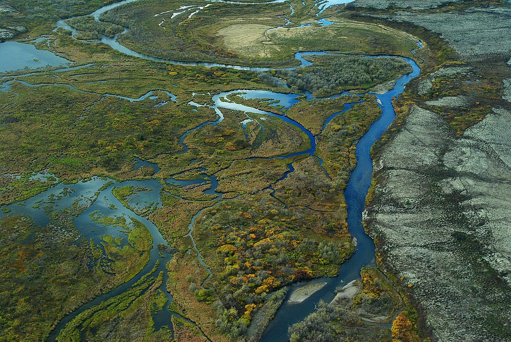
Numerous pollution control programs in the Clean Water Act apply only to WOTUS, and for most people, defining the term is a pretty straightforward matter: The phrase refers to—or at least seems like it would be referring to—the many different bodies of water to be found within the geographical borders of our nation. And according to Jon Devine, the director of NRDC’s federal water policy team, that’s pretty much the correct way to define it.
“Congress intended the phrase to be interpreted very broadly,” says Devine. When lawmakers were drafting the Clean Water Act half a century ago, he says, they envisioned its protections as extending to all the various bodies of water that make up a watershed, many of which people use for recreation, fishing, and drinking-water supply. And while those lawmakers may not have been hydrologists, they nevertheless understood the fundamental interrelatedness of these different bodies of water. “So the very earliest regulations set forth by the EPA were inclusive,” Devine notes. As a jurisdictional matter, WOTUS comprised “all the relevant parts of an aquatic ecosystem, including streams, wetlands, and small ponds—things that aren’t necessarily connected to the tributary system on the surface, but that still bear all kinds of ecological relationships to that system and to one another.”
Still, given the restrictions on how people could interact with these protected waters, interested parties were inclined to litigate the meaning of the term over the decades. “There were always fights about it,” Devine says. “A developer who wanted to bulldoze a wetland, or a polluter who was being prosecuted for dumping into a small stream, would question whether that particular feature should really be considered a water of the United States.” But, as Devine notes, “they largely lost.” And as a result, the more inclusive definition prevailed—or at least it did until the early 2000s, when cracks in that foundation began to develop.
SCOTUS on WOTUS
The most significant development on this front took the form of two separate opinions authored by Supreme Court justices Antonin Scalia and Anthony Kennedy in a 2006 case, Rapanos v. United States. Like Sackett v. EPA, it also involved filling wetlands without a permit to do so. In their individual opinions, Scalia and Kennedy outlined two contrasting ways of identifying which waters merited protection under the Clean Water Act. For Scalia, those that qualified had to be either so-called navigable waters (think rivers, lakes, basically anything that can accommodate a boat), regularly flowing tributaries to those waters, or wetlands—so long as those wetlands had a continuous surface connection to a body of water that already enjoyed federal protection.
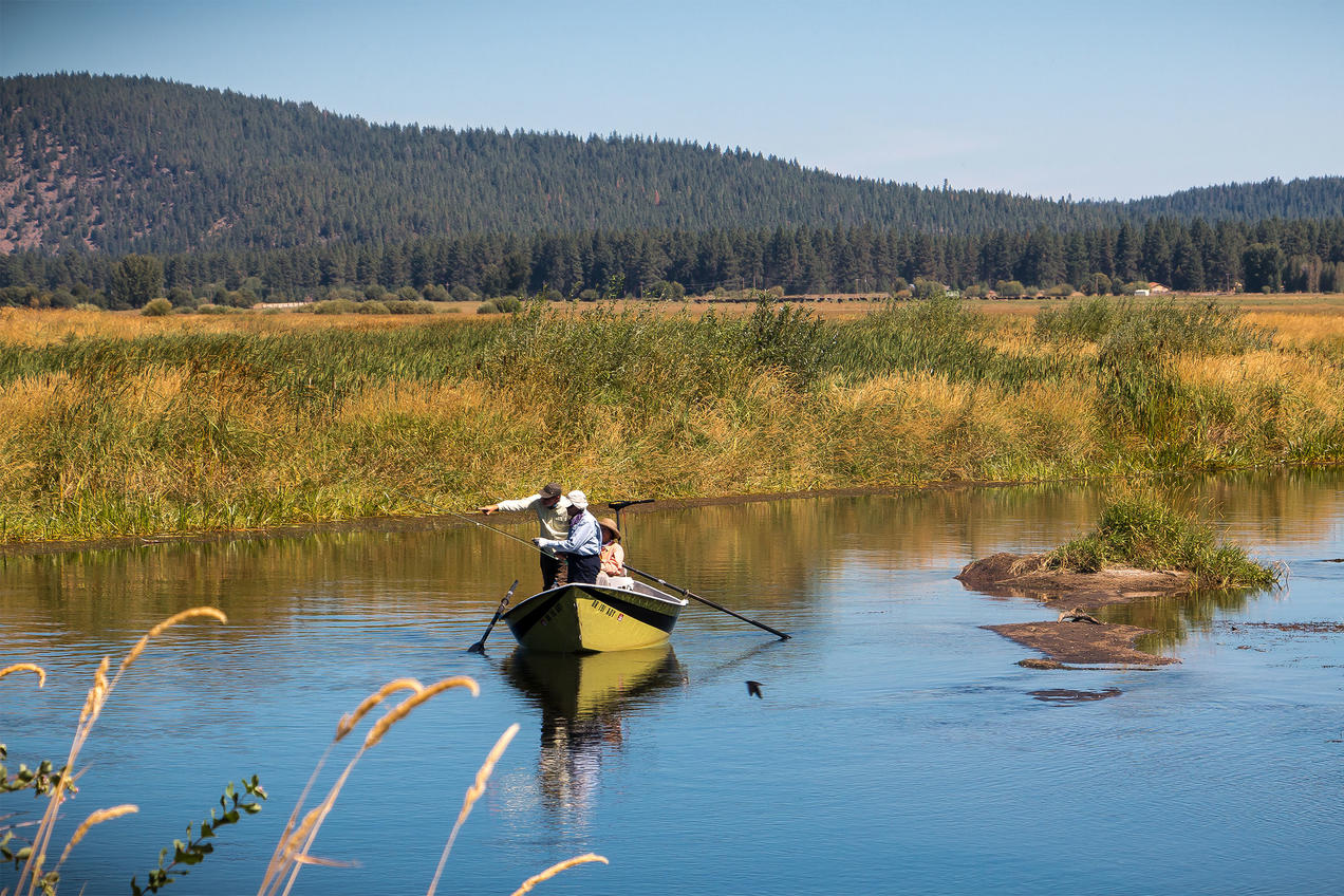
Kennedy saw things differently. He maintained that the connection between wetlands and other bodies of water didn’t necessarily have to be visible—i.e., continuous, and on the surface—but could be measured in other ways. For Kennedy, the far more important question was: Does a given wetland share a significant nexus with another protected body of water? Or (in somewhat plainer English), would polluting or destroying certain wetlands affect the physical, chemical, or biological health of the second body of water? If the answer was yes, Kennedy believed, then both deserved the same level of protection, regardless of whether a boat could easily journey between them.
Although the lower courts consistently ruled that wetlands satisfying Kennedy’s test must be protected (consistent with the views of both the Bush and Obama administrations), polluting industries kept arguing that Scalia’s view should govern. The Trump administration adopted a definition based on the Scalia approach, but it was quickly struck down in court. Which brings us to 2022, and to Sackett—and to the dangerous possibility of a Supreme Court ruling that will adopt a radically narrow view.
The stakes for our wetlands—and water
Wetlands are hugely important. In the words of the EPA, they “are among the most productive ecosystems in the world, comparable to rainforests and coral reefs.” By regulating water flow, they can dramatically lessen the impact of both floods and droughts. They provide habitat for all manner of fish, birds, mammals, insects, reptiles, and amphibians. And they do all of these things while storing massive amounts of carbon in their abundant vegetation—making safeguarding wetlands a valuable natural climate solution.

In a better world, perhaps, those reasons would be enough to ensure that wetlands receive the maximum level of federal protection, but the main question before the Supreme Court right now is: When wetlands are intrinsically connected to other indisputably protected waters, does the Clean Water Act prevent their unregulated pollution and destruction? If not, then the Sacketts’ efforts to get rid of the one on their property wouldn’t need a federal permit, and developers and polluters can celebrate. But if wetlands that are intrinsically connected to other waters are protected, then destroying or polluting them is tantamount to destroying or polluting a lake or a river: an indisputable violation of the Clean Water Act.
For Devine, the answer is clear—so clear that he and his colleagues at NRDC and the Southern Environmental Law Center felt compelled to file a friend-of-the-court brief on the matter, in support of the EPA, that was entered into the court’s docket earlier this year. In that document, Devine says, more than 100 conservation and community organizations argue that “based on the history of the Clean Water Act, and on prior Supreme Court cases, the law—at the very least—protects the kinds of things found on the Sacketts’ property.” Not only is the wetland in question spitting distance from a huge lake that’s also a popular recreational spot, but this particular wetland is also part of a larger complex of wetlands through which water flows, underground, to the lake. And like nearly all other wetlands, it provides all kinds of water purification, water regulation, and wildlife habitat. “The law should protect these wetlands that, the science shows, have such an important effect on downstream waters,” Devine says.
Water flows in all sorts of ways: aboveground; belowground; rapidly, down rivers and streams; and also slowly, through the cleansing filters of the reeds, soils, and grasses that make up a wetland. “The notion that the law can’t protect a body of water, simply because there’s a road between it and another body of water that’s unquestionably protected, is absurd and unscientific,” says Devine. “And it would defeat the purpose of the Clean Water Act.”

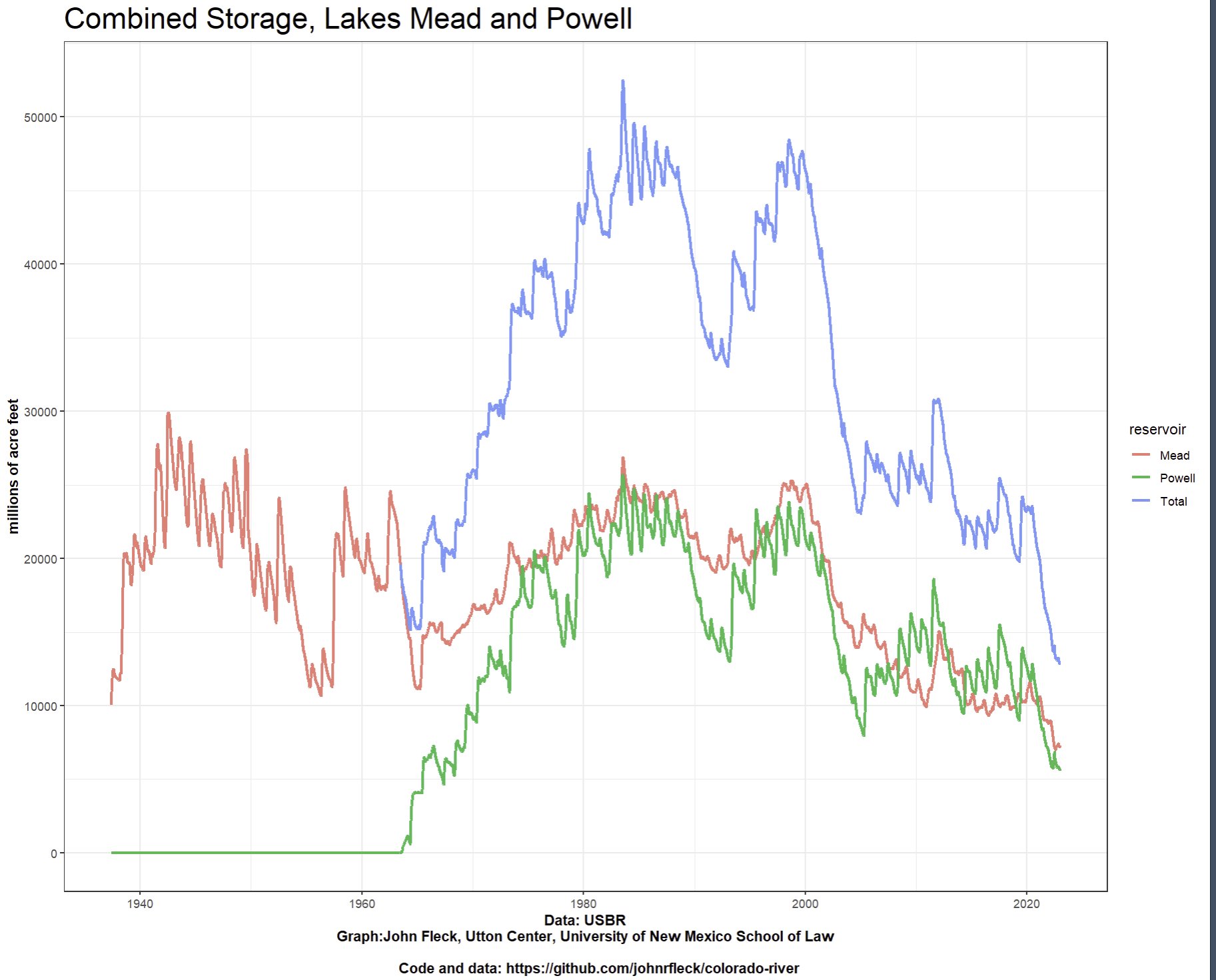
Reminded of the great emptiness
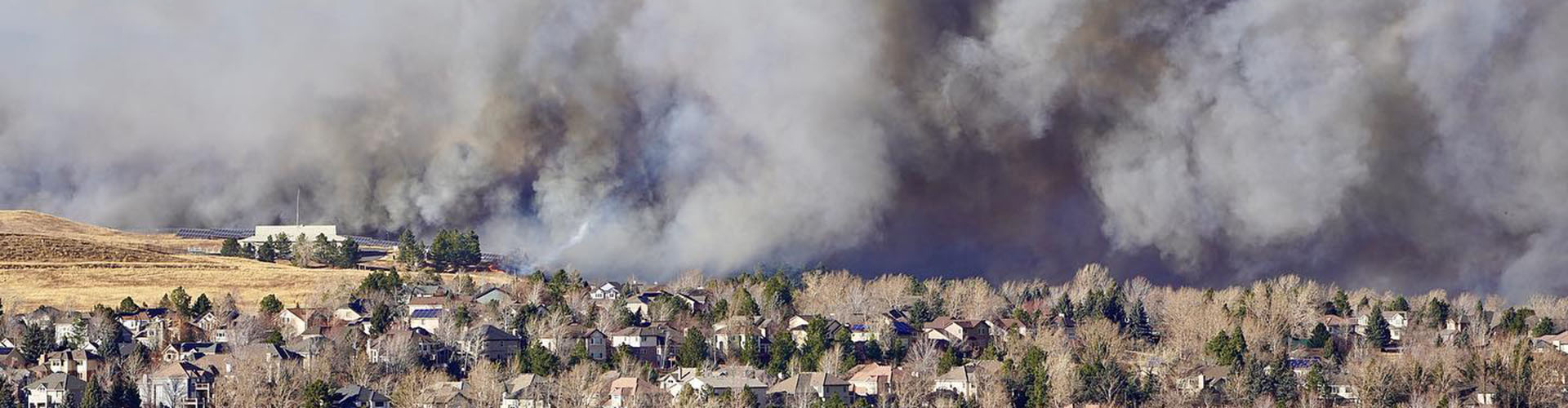
Click the link to read the article on the ProPublica website (Jennifer Oldham):
ProPublica is a Pulitzer Prize-winning investigative newsroom. Sign up for The Big Story newsletter to receive stories like this one in your inbox.
Sheriff’s deputies driving 45 mph couldn’t outpace the flames. Dense smoke, swirling dust and flying plywood obscured the firestorm’s growth and direction, delaying evacuations.
Within minutes, landscaped islands in a Costco parking lot in Superior, Colorado, caught fire as structures became the inferno’s primary fuel. It consumed the Element Hotel, as well as part of a Tesla service center, a Target and the entire Sagamore neighborhood. Across a six-lane freeway, in the town of Louisville, flames rocketed through parks and climbed wooden fences, setting homes ablaze. They spread from one residence to the next in a mere eight minutes, reaching temperatures as high as 1,650 degrees.
On Dec. 30, 2021, more than 35,000 people in Superior and Louisville, as well as unincorporated Boulder County, fled the fire — some so quickly they left barefoot and without their pets. Firefighters abandoned miles of hose in neighborhood driveways to escape.
The Marshall Fire, the most destructive in Colorado history, killed two people and incinerated 1,084 residences and seven businesses within hours. Financial losses are expected to top $2 billion.
The blaze showed that Colorado and much of the West face a fire threat unlike anything they have seen. No longer is the danger limited to homes adjacent to forests. Urban areas are threatened, too.
Yet despite previous warnings of this new threat, ProPublica found Colorado’s response hasn’t kept pace. Legislative efforts to make homes safer by requiring fire-resistant materials in their construction have been repeatedly stymied by developers and municipalities, while taxpayers shoulder the growing cost to put out the fires and rebuild in their aftermath.
Many residents are unaware they are now at risk because federal and state wildfire forecasts and maps also haven’t kept pace with the growing danger to their communities. Indeed, some wildland fire forecasts model urban areas as “non-burnable,” even though the Marshall Fire proved otherwise.
The disaster put an exclamation point on what scientists, planners and federal officials warned for years: Communities outside the traditional wildland-urban interface, or WUI, are now vulnerable as a changing climate, overgrown forests and explosive development across the West fuel ever-unpredictable fire behavior. Fire experts define the WUI, pronounced woo-ee, as areas where plants such as trees, shrubs and grasses are near, or mixed with, homes, power lines, businesses and other human development.
They now agree that instead of a threat confined to the WUI, the entire state, including areas far from forests, may be at risk of a conflagration.
“The Marshall Fire was a horrible, tragic event that served as a wake-up call for the rest of our state,” said state Rep. Lisa Cutter, a Democrat who represents mountain and foothill areas. “I don’t think we realized how much wildfire could impact communities that aren’t deep in the forest — it’s not something any of us are immune to.”
An early warning of the growing danger to suburban communities arrived in 2001. That year, the U.S. Department of Agriculture and other federal agencies identified scores of Colorado municipalities adjacent to public lands as being at high risk of a wildland blaze-turned-urban conflagration. Some of these areas burned in the Marshall Fire.
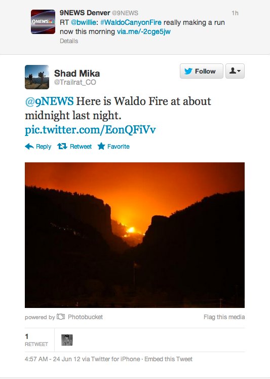
A decade later, in 2012, another warning came, as an unprecedented weather-driven inferno, the Waldo Canyon Fire, destroyed several Colorado Springs neighborhoods.
Afterward, fire experts urged state lawmakers to adopt a model building code that communities in high-risk areas could enact. Such codes have been scientifically proven to reduce risk for residents and rescuers and to increase the odds structures will withstand a blaze by requiring fire-resistant materials on siding, roofs, decks and fences, along with mesh-covered vents that prevent embers from entering.
But lawmakers bowed to pressure from building and real estate lobbyists as well as municipal officials who demanded local control over private property.
Meanwhile, the number of new homes built in Colorado’s WUI — as defined by researchers several years ago — more than doubled between 1990 and 2020. And nationwide, the WUI is growing by 2 million acres a year. Homes in 70,000 communities worth $1.3 trillion are now within the path of a firestorm, according to a June report from the U.S. Fire Administration that featured photos of the Marshall Fire’s destruction.
In the months that followed the Marshall Fire, there were again calls to consider a statewide building code. A last-minute amendment to a fire mitigation bill in May would have created a board to develop statewide building rules, but it was pulled after builders, real estate agents, municipalities and others opposed it.
It wasn’t the first time the state’s powerful building industry asserted its influence over policy. Whenever a wildfire bill comes to the state legislature, well-heeled lobbyists routinely represent the industry, records kept by the Colorado secretary of state show. The state’s culture of local control and the construction industry’s $25 billion annual contribution to the economy hampered lawmakers’ ability to find middle ground on a minimum statewide building code.
ProPublica’s review of legislation introduced from 2014 to 2022 found only 15 out of 77 wildfire-related bills focused primarily on helping homeowners mitigate their risk from fires. Most of the 15 proposals offered incentives to homeowners and communities through income tax deductions or grants — some of which required municipalities to raise matching funds — to clear vegetation around structures.
None called for mandatory building requirements in wildfire-prone areas, even as 15 of the 20 largest wildfires in state history have occurred since 2012.
The lack of uniform regulations has cost the Centennial State millions in federal grant money: The Federal Emergency Management Agency denied the state grants from the agency’s resilient infrastructure funds, which from fiscal 2020 to 2022 totaled $101 million.
Colorado remains one of only eight states without a minimum construction standard for homes.
Developers have also influenced municipalities’ recent decisions, as homes decimated by the Marshall Fire are rebuilt in Boulder County, and the cities of Superior and Louisville located within it. The debate has reflected difficult tradeoffs between the cost of making homes more fire-resistant — particularly in an era of high inflation and unpredictable supply chains — and residents’ tolerance for risk.
Lawmakers in Louisville, where 550 homes and businesses burned, voted to remove a fire sprinkler requirement for homes, citing cost, despite evidence such systems reduce the risk of dying in a home fire by 80%. The City Council also voted to allow residents to choose whether to follow new energy efficiency requirements estimated to add $5,000 to $100,000 to the cost of a new home.
By contrast, in unincorporated Boulder County, which lost 157 homes to the Marshall Fire, commissioners in June voted to require fire-resistant materials on all new and renovated homes. Before the inferno, the eastern grasslands were exempt. (Mountain residents, who since 1989 have been required to follow mitigation practices, have seen the effectiveness of such codes: Eight out of 10 of their homes survived the Fourmile Canyon Fire in 2010.)
In Superior, which lost 378 structures, the Board of Trustees voted down a proposed citywide WUI building code in May. After residents of the leveled Sagamore neighborhood requested they revisit their decision, trustees reconsidered in July.
The financial pressures facing Superior officials and their constituents were evident as they considered whether to require fire-resistant materials solely for homes destroyed by the Marshall Fire or for the entire city.
“This is all a huge cost we cannot bear,” said Robert Lousberg, a resident who wants to rebuild several homes. “I understood this is a once-in-a-lifetime fire.”
Some neighbors disagreed.
“Sagamore burned down in less than an hour — one of my neighbors ended up in the hospital after trying to escape the fire on foot — that’s the main reason we need these codes, to slow the spread of fire,” Dan Cole said. “We have an opportunity to build a more fire-resistant neighborhood right now, and it would be foolish and short sighted not to take it.”
Builders estimated that costs for tempered-glass windows, fire-resistant siding and other materials could reach $5,500 to $30,000 per home. Procuring the materials and labor to install them could delay rebuilding.
Like residents, town trustees were divided about whether the cost outweighed safety benefits to residents and first responders should there be another conflagration.
“To me, it’s unconscionable to have people rebuilding in an unsafe manner,” said Trustee Laura Skladzinski, who did not seek reelection last month. “I would rather have residents pay $20,000 now. If they cannot afford it, how are they going to be able to afford it when their house burns down?”
Some noted that most residents didn’t have enough insurance to cover the cost of rebuilding their homes.
Trustee Neal Shah said the city should have adopted tougher codes after the 2012 Waldo Canyon Fire in Colorado Springs, which prompted calls for a voluntary statewide building code that communities could institute requiring fire-resistant materials in homes.
“I fundamentally believe in WUI standards,” Shah said, “what I can’t solve is the math.”
The body voted 5-1 to institute the code, then added an opt-out clause for those rebuilding their residences.
A decade before the Marshall Fire, a blaze was burning in the mountains above Colorado Springs on a 101-degree June day. That afternoon a thunderstorm caused a sudden shift in the wind, pushing a wall of burning debris out of the Rocky Mountain foothills into the state’s second-largest city.
Firefighters fled the 750-foot-high fire front — as tall as a 53-floor building — as it chewed through pine, pinyon and juniper dried by a record-hot spring. Sixty-mile-per-hour gusts peeled back the door on a fire truck. Fist-sized embers rained down on the city’s Mountain Shadows community. The fire incinerated 79 homes per hour, or 1.3 per minute, over 5 ½ hours, a report found.
In the aftermath of the Waldo Canyon Fire, which destroyed 347 homes and killed two people, Colorado Springs drew lessons from which residences had survived and capitalized on fresh memories of burned neighborhoods to institute tougher building requirements.
Standing recently in the shade of a still-scorched tree behind her home, Patty Johnson described how her house was relatively unscathed, even as eight of her neighbors lost their residences. She credited ignition-resistant materials, including stucco walls, siding, a composite deck and a concrete tile roof. Drought-resistant landscaping also helped. Her family sold the home in September to move into a smaller place in the city.
After-action reports found neighbors’ work clearing vegetation around homes helped firefighters save 82% of residences in the 28-square-mile burn area.
FEMA estimated that minimal expenditures to protect Colorado Springs neighborhoods had paid off. In Cedar Heights, $300,000 in mitigation had prevented about $77 million in losses.
“The Waldo Canyon Fire was shocking, but it could have been so much worse if the city of Colorado Springs had not spent decades getting ready,” said Molly Mowery, co-founder of the Community Wildfire Planning Center.
Even so, the fire reached 2,000 degrees and moved so fast it incinerated some homes with fire-resistant material and fire-proof safes inside.
Nevertheless, the city followed a 30-year pattern and took its lessons to heart to institute additional building requirements to fortify homes in wildfire-prone areas. Timing was everything, Mowery’s nonprofit concluded in a recently released analysis.
The city had done the same in 2002. With smoke still in the air following the Hayman Fire — which started about 35 miles northwest of the city and destroyed 600 structures — a coalition of fire officials, homeowners’ associations and local builders and roofing contractors devised rules that banned wood roofs on all new homes and repairs greater than 25% of the total roof area.
Similarly, after the Waldo Canyon Fire, as heavy machinery cleared charred neighborhoods, the city updated its code to increase the distance trees had to be from homes and require fire protection systems, ignition-resistant siding and decks, and double-paned windows for all new or reconstructed homes in hillside areas.
Fire officials used spatial technology to hone the city’s definition of the WUI. The tool identified a 32,655-acre area — one of the largest high-risk regions in the United States. The city recruited homeowners to educate neighbors in the threatened area about fire-resistant practices.
Peer pressure worked, said Ashley Whitworth, wildfire mitigation program administrator at the Colorado Springs Fire Department. If a homeowner’s property is flagged red on the city’s online risk assessment map (denoting it needs work), neighbors reach out to learn why they haven’t completed mitigation.
Colorado Springs’ voters overwhelmingly approved the allocation of $20 million in city funds toward incentives to gird wildfire-prone properties.
Days after the vote in November 2021, the Marshall Fire unfolded 90 miles to the north across communities with little history of wildfire mitigation.
Scientists, some of whom lived in Boulder County and were evacuated, proclaimed it a “climate fire.” They cited the extreme weather that preceded it: Abnormally high levels of snow and rain in spring and summer had nurtured abundant 4-foot grasses that baked to a crisp during a historically dry fall. Chinook winds blasted the region for an unusual nine-hour period and propelled the firestorm. And even though there’s growing understanding that fire season is now year-round, no one believed a December blaze could ravage entire cities.
While it began as a wildfire in grassland, once it reached nearby communities it transformed into an urban conflagration — the type of fire that destroyed Chicago in 1871 and San Francisco in 1906 and that until the early 20th century consumed more property than any other type of natural disaster.
“Was this a wildland fire or an urban fire?” Sterling Folden, deputy chief of the Mountain View Fire Protection District, asked during a July legislative committee meeting. “I had five fire trucks in the entire downtown of Superior — I had 20 blocks on fire — I usually have that many for one house on fire.”
Whitworth, of the Colorado Springs Fire Department, said there were more lessons to learn about the threat of wildfire.
“The Marshall Fire was a really big hit for people here because it happened in December and it happened just like that,” Whitworth said. “Everyone said to me, ‘It could happen here,’ and I said, ‘You’re absolutely right.’”
With the 2023 legislative session days away, fire chiefs, county commissioners, scientists and planners are once again calling on Colorado lawmakers to institute statewide rules that mandate fire-resistant materials in high-risk areas.
Cutter, who will be sworn in as a state senator in January, is developing a bill that would require the state to create a WUI code board to write minimum fire-resistant building requirements. It’s patterned in part after the amendment that failed at the Capitol this spring.
Such laws save lives, said Mike Morgan, director of the Colorado Division of Fire Prevention and Control. The 36-year fire service veteran cited studies from the nonprofit Fire Safety Research Institute and the federal National Institute of Standards and Technology showing that building codes work.
“Firefighters take extraordinary risk to protect lives and property,” he added. “If we start building communities and structures out of materials more resistive to fire, we are upping our odds of success — we’ve got to do something different and do it better.”
The insurance industry is also warning that if Colorado lawmakers and communities don’t reinforce homes against wildfire, mounting claims from blazes could put premiums out of reach for many. The industry supports a statewide building code.
“Unlike other disasters, wildfire is one of those risks there is much we can do from a mitigation standpoint to put odds at least in favor of that home surviving,” said Carole Walker, executive director of the Rocky Mountain Insurance Information Association.
“We’ve got to get it done,” she added. “Colorado right now is at … a tipping point with concerns about keeping insurance here and keeping insurance available.”
But such rules won’t be adopted without a compromise among local control advocates, builders and fire officials.
Construction industry representatives who met with Cutter and Morgan recently said builders are wary of one-size-fits-all requirements imposed by the state. Together with the insurance industry and municipal governments, they have met the past few months seeking to influence the bill’s language.
“It’s important to make sure we match codes with risk,” said Ted Leighty, chief executive of the Colorado Association of Home Builders. His members “are not opposed to talking about what a code board might look like — if we were to adopt a model code that local governments could adopt to match their communities’ needs.”
The idea for such a board emerged after the Colorado Fire Commission received a letter from Gov. Jared Polis in July 2021.
The first-term Democrat, who was reelected in November, sent the missive following conflagrations in 2020 that exhibited unimaginable fire behavior: The 193,812-acre East Troublesome Fire traveled 25 miles overnight and incinerated 366 homes; and the 208,913-acre Cameron Peak Fire, which torched 461 structures, burned for four months despite firefighters’ efforts.
Polis wrote that legislators in 2021 had failed to “address a critical piece of the wildfire puzzle in Colorado: land use planning, development and building resiliency in the wildland-urban interface.”
Instead, lawmakers focused on fire response, restoration of burned lands and voluntary mitigation by communities.
In answer to Polis’ missive, a little-known subcommittee, which included state, county and city fire officials, met between August 2021 and April. The 51-member group agreed it’s time to rethink which communities are prone to wildfire, offering a new definition of the WUI: The group concluded “almost the entire state of Colorado falls within the WUI,” according to minutes from a Feb. 10 meeting, “which could make a strong argument for adopting a minimum code.”
Fire officials also countered the long-held belief that communities favor local control over building requirements. They pointed to a 2019 law that established a minimum energy code that local jurisdictions must adopt when they update local building codes. About 86% of the state’s 5 million residents now live in a community that mandates such measures.
“There is minimal evidence that people voluntarily regulate themselves,” committee members concluded, according to minutes of their Feb. 28 meeting.
A report on the Marshall Fire released in October by the Colorado Division of Fire Prevention and Control noted how wooden fences abutting grasslands had accelerated the blaze’s spread, leading flames from the grass directly to homes. Firefighters also described fence pickets flying past at 80 mph and landing to start new fires.
This month, as homes were being rebuilt on Cherrywood Lane in Louisville, in one of the hardest-hit neighborhoods, evidence remained of first responders’ frantic efforts to cut down fences to prevent them from spreading flames to neighboring homes.
New homes are going up across the 9-square-mile burn zone. A recent drive through the area revealed many are being rebuilt with the same kinds of fences. With no building code dictating that the fences be made of fire-resistant materials, homeowners are using flammable materials that have been standard in the past, unaware it will again put them at risk in the next blaze.
Wooden fences such as these touch homes and grasslands in communities up and down the eastern edge of the Rocky Mountains.
Rebuilding without ignition-resistant barriers leaves the homes vulnerable to the next climate-driven wildfire, said Morgan, the state fire chief.
This month, with snow on the ground and temperatures in the 40s, another blaze ignited not far from where the Marshall Fire burned. Thirty-five-mile-per-hour winds spread the flames and forced evacuations before the threat subsided.
“I’ve heard people say the Marshall Fire was just a fluke,” he said. “I would disagree — there are literally thousands of communities along the Front Range of the Rockies from Canada to New Mexico subject to these Chinook winds multiple times a year, and when the conditions are right this can happen.”

Click the link to read the article on The Los Angeles Times website (Ian James). Here’s an excerpt:
Water supplies are shrinking throughout the Southwest, from the Rocky Mountains to California, with the flow of the Colorado River declining and groundwater levels dropping in many areas. The mounting strains on the region’s water supplies are bringing new questions about the unrestrained growth of sprawling suburbs. [Kathleen] Ferris, a researcher at Arizona State University’s Kyl Center for Water Policy, is convinced that growth is surpassing the water limits in parts of Arizona, and she worries that the development boom is on a collision course with the aridification of the Southwest and the finite supply of groundwater that can be pumped from desert aquifers.
For decades, Arizona’s cities and suburbs have been among the fastest growing in the country. In most areas, water scarcity has yet to substantially slow the march of development. But as drought, climate change and the chronic overuse of water drain the Colorado River’s reservoirs, federal authorities are demanding the largest reduction ever in water diversions in an effort to avoid “dead pool” — the point at which reservoir levels fall so low that water stops flowing downriver. Already, Arizona is being forced to take 21% less water from the Colorado River, and larger cuts will be needed as the crisis deepens…
To deal with those reductions and access other supplies to serve growth, the state is turning more heavily to its underground aquifers. As new subdivisions continue to spring up, workers are busy drilling new wells. Ferris and others warn, however, that allowing development reliant solely on groundwater is unsustainable, and that the solution should be to curb growth in areas without sufficient water.
“What we’re going to see is more and more pressure on groundwater,” Ferris said. “And what will happen to our groundwater then?”
Click the link to read the article on the Big Pivots website (Allen Best):
The story so far. Triggered by the oil embargoes of the 1970s, Colorado became a forum for explorations of alternative futures for energy. One outcome was creation of a grassroots organization called the Colorado Renewable Energy Society was created in 1996. The organization aimed to provide education, but it also part of a team effort early on to show why Colorado’s largest utility should buy wind power at a project called Colorado Green.
The 2004 success of Amendment 37, Colorado’s first renewable energy mandate, was preceded by nearly a decade of failure. Mark Udall, a Democratic state legislator from Boulder County in the 1990s, had sponsored legislation that proposed to give consumers rights to choose clean energy. He couldn’t get it across the legislative finish line. After Udall went to Congress in 1998, his mission was taken up by what some might have seen an unlikely source, a Republican legislator from rural Colorado.
That legislator, Lola Spradley, the first female speaker of the Colorado House of Representatives, had grown up on a farm in Weld County. There, when crops failed, production royalties from “stripper” oil wells—those nearing the end of their productive life—paid the farm’s property taxes. She saw wind turbines being the equivalent of oil wells, a way to secure income for rural landowners in years of crop failures. Lehr says she told him that she also understood the power of a large monopoly because she had worked for AT&T when it was called “Ma Bell” in Colorado and enjoyed a monopoly on telecommunications. She said she understood irrational monopoly behavior toward suppliers and their general aversion to change.
Spradley, representing rural areas of southern Colorado, three times beginning in 2001 proposed the minimum renewable energy standard along with Democratic colleagues from Boulder County. Votes were narrow, but she always fell short.
Rick Gilliam, then with Western Resource Advocates, tells about rising frustration with the legislative process. But although popular accounts have always fingered Xcel Energy as the stick in the renewable mud, he tells a more nuanced story.
“Really it was the coops that stopped it,” he says. “And here’s the thing: It didn’t even apply to them. It would not have applied to any of the coops. They talked about how dangerous renewables would be. In fact, I remember a guy (likely the individual who then directed the Colorado Rural Electric Association) who testified during a committee hearing in the third year we made a run about this. He was arguing against rooftop solar. ‘If you pass this bill, people are going to die,’ he said. I almost laughed out loud, because it was so ludicrous to go to that extreme to try to scare people. I don’t think many of the legislators took him seriously. But it showed how worried and maybe even scared the coops were.”
Finally, that third year, Matt Baker—who was then head of Environment Colorado—proposed a back-up plan. If legislators said no again, then they would make their case directly to voters through a ballot initiative.
That’s what they did. They needed 68,000 signatures to get on the ballot. The allied environmental groups and CRES delivered 115,000. Baker and Gilliam became the most prominent public faces for the advocates.
Gilliam had a wealth of experience on several sides of the energy equation. His first job out of college was with the Federal Energy Regulatory commission in Washington D.C. After six years there, he was offered a position with the Public Service Co. He immediately fell in love with Colorado. He stayed with the company for 12 years and acquired an education in how investor-owned utilities operate and their relations with state regulators. In addition to energy efficiency and demand-management programs, he helped figure out how to shut down St. Vrain, then a trouble-plagued nuclear reactor, and replace it with natural gas-fired generation.
In 1993, he made another career move, this time going to work for Western Resource Advocates. His recruiter there was Eric Blank, who is now chairman of the Colorado Public Utilities Commission. Gilliam agreed to a year-long term that turned into 12.
During his time while still at Xcel he had also begun thinking about an alternative energy paradigm. A pivotal experience was leading a tour of Pawnee, the coal-fired power plant near Brush that began operations in 1984. He remembers the dirtiness of coal, wondering if there was a better way. Reading the works of Amory Lovins in Sierra Club bulletins and elsewhere, Gilliam became persuaded by solar energy in particular.
“I always thought it was the coolest technology. It is lovely because it has no moving parts. You just put it out there and it generates electricity.”
On the campaign trail that summer, Gilliam and others found a mostly receptive audience along the Front Range. Fort Collins, for example, had already adopted renewables requirement for its city utility, requiring that 15% of its power come from wind sources by 2015, double what was being proposed for Colorado.
In rural Colorado, the reception was mixed. Rocky Mountain Farmers Union favored the initiative, and the Farm Bureau opposed it.
For some audiences Spradley had a colorful analogy. She described the wind turbines as upside down oil wells. Her view was that it would “keep people on the farm.”
Later, Gilliam and other advocates learned that Xcel had had a strong conversation within its corporate ranks about what position to take. In the end, says Gilliam, the utility seems to have been persuaded by Tri-State Generation and Transmission, Colorado’s second largest utility, about the need for a united front.
“Don’t downplay their opposition too much,” he says. “But they didn’t feel internally near as strongly as Tri-State did.”
Advocates lined up 1,000 volunteers – including many members of CRES. Video scenes for the campaign commercials were provided by Dave Bowden, president of CRES in 2004, who led the group’s fundraising and voter education efforts for the ballot initiative.
Early polling showed 70% to 75% of Colorado voters favoring Amendment 37.
Advocates secured funding for $500,0000 (including $10,000 from CRES), mostly for TV commercials. Xcel, Tri-State, and Washington-based utility trade groups raised $1.5 million, outspending the advocates three to one. Had they started earlier, they might have defeated the initiative. It passed 53.4% to 46.6%. It was the nation’s first voter-initiated renewable-energy standard and a huge victory for CRES and Colorado’s clean energy champions.
Momentum was building: First Colorado Green, then Amendment 37.
What followed soon after was Colorado’s first gubernatorial campaign built on the premise of renewable energy. Its proponent? A one-time farm boy named Bill Ritter Jr.
Next: Next: Bill Ritter was in a tight race until he fired his advertising team and made a commercial that he wanted standing in front of the wind turbines in southeastern Colorado..
What you may have missed in this series:
Part 1: A coming together of minds in Colorado.
Part 2: Why note wind?
Or download the whole series in one e-magazine of Big Pivots 64.

“We pray for the rains to come, for the snow to fall, for moisture in the earth. Not just for the Hopi, but for everybody. For every living thing that’s out there.” – Dennis Hopper, Hopi Elder
The Green and Colorado river systems form the backbone of the American West. Once spanning a 1,450-mile journey from the Rocky Mountains to the Gulf of California, today, none of the sediment-rich water reaches the Pacific Ocean. Instead, its water lies stymied in reservoirs and siphoned off to feed and nurture 40 million people from Salt Lake to Los Angeles.
One hundred and fifty years after John Wesley Powell’s historic descent of the Green and Colorado rivers, an unlikely crew of scientists, artists, educators, and river lovers repeated his journey on a trip that was simultaneously a celebration of modern river life and a critical look at how we interpret the Colorado River’s history and use its waters.
As the demand we place on the water of the Colorado continues to exceed its supply, we are forced to face uncomfortable truths about decisions made in our past. And we are reminded that the way we think about water—and all those dependent upon it—needs to shift if we want things to change for our future.
“Water is a life force for all of us. It has a spiritual and physical being to it that deserves respect. It’s not something that you take for granted.” – Lyle Balenquah, Hopi archaeologist


Click the link to read the release on the Colorado Law website:
“It is an incredible honor to accept the award on behalf of the hundreds of students, dozens of supervising attorneys, and many community partners who have advanced environmental justice for Colorado’s acequias over the past decade,” remarked Gregor MacGregor, faculty fellow at the University of Colorado Law School and director of the Acequia Assistance Project. “My special thanks to Professor Sarah Krakoff, Peter Nichols ’01, and Sarah Parmar for launching the Project. A further thank-you to alumnus Don Brown ’89 and the University’s Outreach Office, whose generous funding allows us to support Colorado’s acequias and the professional growth of our students. And finally, my sincerest gratitude goes out to the acequia members who continue to invite us to work and learn in their beautiful community. The Deputy Directors and I are honored to continue the Project’s work on behalf of our community partners and students. Thank you.”
The Acequia Assistance Project is an environmental justice program at the University of Colorado Law School that provides pro bono legal services to southern Colorado’s Hispanic agricultural community. For the last ten years, law students, faculty, and pro bono attorneys have helped these irrigation ditches, acequias, to realize their water rights after the Acequia Recognition Act remedied 120 years of exclusion from Colorado’s water law regime.

Acequia is an Arabic word that means “water bearer.” An acequia is a physical irrigation system but the term “acequia” in northern New Mexico and southern Colorado also describes a philosophy about water and community– that water is so essential to life that it is a communal resource, one which must be shared. Acequias are found along the southernmost part of Colorado – including four of the state’s poorest counties: Costilla, Conejos, Huerfano, and Las Animas. While water is wealth throughout the arid West, to the small-scale farmer in these traditional communities the acequia culture represents even more: Acequias are how you support your family and how you participate in your community.
Founded as a passion project by Professor Sarah Krakoff, Colorado Law alumnus water attorney Peter Nichols ‘01, and Colorado Open Lands’ Sarah Parmar, the Project provides Hispanic farmers with a full suite of legal services related to their water rights, including: representation in Colorado’s Water Courts; researching legal issues pertinent to the community as a whole; title research; bylaws drafting and amending; mediation; incorporation; water rights historic use collection; and drafting water rights purchase and sale agreements.
For the 2021-2022 school year, the Project included 42 students, 5 pro bono attorneys, and 15 cases. In 2019, the last full year pre-COVID, the Project provided nearly $300,000 of legal services with an operating budget of only $8,000 from the University’s Outreach funding. Funding covers the costs of student travel, filing fees, and other incidental costs. All attorney and student participation is entirely voluntary.
“I could not be more proud to see the Acequia Project’s many years of dedicated efforts recognized in such a profound way,” commented dean of the law school Lolita Buckner Inniss. “The students, alumni, faculty, and community partners’ dedication to promoting these communities’ access to the courts and effective management of resources is inspiring. Its role in instilling a commitment to environmental justice in hundreds of Colorado’s best and brightest future attorneys is truly invaluable.”
Interested in supporting the Acequia Project? Head to the CU Foundation’s Giving Site to make your contribution to the Getches-Wilkinson Center for Natural Resources, Energy and the Environment.


Click the link to read the release on the American Rivers website (Katie Schmidt):
On December 15th, 2022, the Senate voted to pass the National Defense Authorization Act in which the Water Resources Development Act of 2022 (WRDA 2022) is included. It was passed by a vote of 83-11. Last week, the House passed the bill on December 8th with an overwhelming majority of 350-80. It will now go to President Biden’s desk for signing into law.
This is the largest Water Resources Development Act (WRDA) in history and comes in at a time when our nation needs it most. The bill provides authorization for the Army Corps of Engineers to carry out water resources infrastructure projects to address flooding, waterway transportation, and ecosystem restoration. Importantly, this bill includes provisions to support Tribal and underserved communities, and address climate change.
American Rivers has worked with Congress to include provisions to protect and restore our nation’s rivers and floodplains. Below are some of the key provisions that we are most excited about.
Sections 8111. Tribal Partnership Program; 8112. Tribal Liaison; 8113. Tribal Assistance; 8114. Cost sharing provisions for the territories and Indian Tribes; and 8115. Tribal and Economically Disadvantaged Communities Advisory Committee are valuable provisions. We support these efforts to improve outreach to, and engagement with, these communities and give them a seat at the table. We are also pleased to see the initiative to build out the Corps of Engineers workforce through outreach in schools, colleges, and universities with a prioritization of recruiting from economically disadvantaged communities. We believe these steps will serve both the Corps and the communities well.
With climate change impacting the nation, promoting nature-based approaches on a project and watershed level scale is imperative to adapt to increasing floods and water scarcity. WRDA 2022 includes several provisions that will help promote the use of nature-based approaches and better serve and protect our communities while promoting ecosystem resilience through more responsible levee management and floodplain restoration.
Section 8103 – Shoreline and riverbank protection and restoration mission calls for restoring the natural functions and values of rivers and shorelines throughout the United States. Section 8121– Assessment of Corps of Engineers levees, will assess for opportunities for modification of levees, including for restoring connections with adjacent floodplains. American Rivers also worked to include language for the Corps to identify floodplain reconnection opportunities on federal lands. While this provision was not included in the final bill, we will work with the Corps to support sections 8103 and 8121, while continuing to work on getting additional federal levees assessed.

American Rivers worked diligently with our partners at American Whitewater and the Theodore Roosevelt Conservation Partnership to include section 8122- National Low-Head Dam Inventory. This inventory will contribute significantly to public safety as low-head dams are known public safety hazards, and yet not inventoried nationally, and making this information publicly available will help river users identify life-threatening low-head dams. We also hope that this inventory will help the public identify obsolete structures that continue to pose a safety hazard and would be suitable for removal. In areas where dam removal is not an option, we support additional funding to go towards grants for signage and public education about low-head dams
Section 8123– Expediting hydropower at Corps of Engineers facilities, allows for retrofitting Corps dams with hydropower. We support this provision with the understanding that the structures in question are already serving their legislatively authorized purpose and will continue to do so for the foreseeable future. Recognizing that retrofitting a non-powered Corps dam with hydropower is not always feasible, we will continue to advocate for the diligent assessment of these projects and their use to determine if they would better serve the taxpayers, community, and local ecosystem by being disposed of instead of extending their life solely for non-power purposes.

The consideration of reforestation in section 8137 is an exciting and forward-thinking provision that encourages measures to restore swamps and other wetland forests in studies for water resources development projects. This is another important step towards focusing on ecosystem restoration. The benefits of flood control and water quality improvements that come from healthy swamps and wetlands are incalculable.
There are several provisions related to river restoration and protection and better river management, including section 8144 – Chattahoochee River Program, section 8145 – Lower Mississippi River Basin demonstration program, and section 8219 – Hydraulic evaluation of Upper Mississippi River and Illinois River. The Chattahoochee River program will provide assistance to non-federal interests for water-related resource protection and restoration projects affecting the Chattahoochee River Basin. The Lower Mississippi program will provide assistance to non-federal interests for projects focused on flood or coastal storm risk management or aquatic ecosystem restoration. The hydraulic evaluation of the Upper Mississippi River and Illinois River basins will provide studies on the flows for rivers in the upper basin, which we hope will contribute to more effective management and restoration plans.
The Government Accountability Office (GAO) studies authorized in section 8236 are encouraging, especially the review of mitigation projects and the evaluation of their performance. These studies will require a report on the results of projects and activities to mitigate fish and wildlife losses that occurred as a result of a water resources development project. Within this section, we also support the study on the integration of information into the national levee database as this information is essential to the management and improvement of our nation’s levees.
We are pleased to see section 8140 – Policy and technical standards directing the Secretary to update the agency standards. With this update, the Corps will have to include climate change and nature-based solutions in their practices. We look forward to the report on the Corps of Engineers reservoirs under section 8153 so that Congress may further evaluate the operation, utility, and future of these reservoirs.
Overall, we applaud the safety and environmental provisions in this bill and the passing of this paramount piece of legislation to protect our natural and engineered water infrastructure and the people that rely on it.
Section by section summary can be found here and the full WRDA bill can be found here.
This blog was written by Katie Schmidt. Jaime Sigaran, Ted Illston, Brian Graber, and Eileen Shader

Click the link to read the guest column on The New York Times website (Natalie Koch). Here’s an excerpt:
Arizona’s water is running worryingly low. Amid the worst drought in more than a millennium, which has left communities across the state with barren wells, the state is depleting what remains of its precious groundwater. Much of it goes to private companies nearly free, including Saudi Arabia’s largest dairy company.
Thanks to fresh scrutiny this year from state politicians, water activists and journalists, the Saudi agricultural giant Almarai has emerged as an unlikely antagonist in the water crisis. The company, through its subsidiary Fondomonte, has been buying and leasing land across western Arizona since 2014. This year The Arizona Republic published a report showing that the Arizona State Land Department has been leasing 3,500 acres of public land to Almarai for a suspiciously low price. The case has prompted calls for an investigation into how a foreign company wound up taking the state’s dwindling water supplies for a fee that might be as low as one-sixth the market rate. But the focus on the Saudi scheme obscures a more fundamental problem: pumping groundwater in Arizona remains largely unregulated. It’s this legal failing that, in part, allows the Saudi company to draw unlimited amounts of water to grow an alfalfa crop that feeds dairy cows 8,000 miles away. Even if Fondomonte leaves the state, it will be only a matter of time before Arizona sucks its aquifers dry. While a 1980 state law regulates groundwater use in a handful of urban areas, water overuse is common even in these places. The situation is worse in the roughly 80 percent of Arizona’s territory that falls outside these regulations. In most of rural Arizona, whoever has the money to drill a well can continue to pump till the very last drop…
Many more agricultural operations are drawing down the state’s underground water reserves for free. And most of them are U.S.-owned. Minnesota’s Riverview Dairy company, for example, has a farm near Sunizona, Ariz., that has drained so much of the aquifer that local residents have seen their wells dry up. Meanwhile, some California-based farms, facing tougher groundwater regulations at home, are looking to relocate to neighboring Arizona for cheap water. These companies and other megafarms can afford to drill deep wells, chasing the rapidly sinking water table.
And it’s not just farming operations. Other sectors like mining and the military, which have a huge presence in the state, also benefit from Arizona’s lax water laws. It’s difficult to know how much water is being used up by one of the state’s largest employers, Raytheon Missiles and Defense, which, like Almarai, has a footprint in Arizona and Saudi Arabia. But manufacturing missiles has a water cost, too. And like Fondomonte’s alfalfa, Raytheon’s product is being shipped to Saudi Arabia.
The Saudi farm scandal may have helped to spotlight the severity of Arizona’s water crisis, but the state will have to go further to address the root cause. Arizona needs to apply groundwater pumping regulations across the entire state, not just in its metropolitan areas. It won’t be easy. This year special interest groups scuttled a far more modest effort that would have allowed rural communities to opt in to groundwater enforcement. In all likelihood, when these groups have to pay fair prices for water, they will have to give up on growing water-hungry crops like alfalfa in the desert. This kind of race-to-the-bottom approach to water in Arizona is insupportable today, if it ever was.
Click the link to read the white paper on the Family Farm Alliance website (Dan Keppen and Mike Wade). Here’s an excerpt:
Alfalfa is often the target of journalists and some critics of irrigated agriculture who frequently rely upon simplistic explanations to heap scorn upon growing a forage crop in the West, particularly in times of drought. The attack on alfalfa has intensified in the wake of U.S. Bureau of Reclamation Commissioner Camille Touton’s June 14, 2022 appearance before a Senate committee, where she called on water users across the Colorado River Basin to take actions to prevent Lake Powell and Lake Mead from falling to critically low elevations that would threaten water deliveries and power production.
When the states failed to meet the mid-August deadline set by Commissioner Touton for them to propose 15% to 30% cuts to their water use, critics of irrigated agriculture ramped up their focus on the perceived easy “fix” to the complicated challenges facing the Colorado River: stop growing crops that they believe use lots of water….like alfalfa.
The “shot across the bow” against alfalfa production was fired by the witness who testified immediately after Commissioner Touton at the June 14th Senate hearing. The general manager of the Southern Nevada Water Authority (SNWA), whose member agencies serve more than 2.2 million residents in Southern Nevada, summarized the impressive urban efforts to reduce per-capita water use and further suggested that farmers reconsider growing crops like alfalfa. The solution, he said, is working toward “a degree of demand management previously considered unattainable.”
He also noted that SNWA is planning to serve a population that will swell to 3.8 million by 2072.
In August, SNWA followed up with a strongly worded letter to the Biden administration, demanding action on several fronts, including creating “beneficial use criteria for Lower Basin water users, eliminating wasteful and antiquated water use practices and uses of water no longer appropriate for this Basin’s limited resources”.
In the following weeks, a steady stream of media coverage, including a 1,600-word essay in High Country News, have carried a similar message: Growing less hay is the only way to keep the Colorado River’s water system from collapsing.
Some journalists love going after crops that use lots of water. Almond growers in California’s Central Valley were subjected to a merciless multi-year “one almond uses one gallon of water” campaign during the last “unprecedented” drought that hit the Golden State in the last decade.
Guess what? Years later, Central Valley farmers still grow them because consumers around the globe love almonds and consume them in mass quantities for their great taste and dense nutritional punch.
Simplistic examinations of alfalfa in terms of water demand vs. supply must be enhanced and balanced with discussion of productivity, economic return, food production, and the environment to be truly productive. A former Imperial Irrigation District (IID) board member once said that the definition of a low-value crop is one that’s grown with the water someone else wants.
On behalf of the California Farm Water Coalition and the Family Farm Alliance, we offer this brief bit of continuing education to help you understand the rest of the story about alfalfa production in the Colorado River Basin and other parts of the American West.
Alfalfa 101: The Rest of the Story
The alfalfa sales pitch is a good one, because there’s such a good story behind it. That’s not just a load of hay you see rumbling by on Western highways during summer months. Those hay bales form the foundation of rural agriculture in many Western rural communities. Alfalfa is not only a food source for livestock, it also has important environmental attributes.
Importantly, alfalfa actually has a key role to play in the water-uncertain future of the West due to its high flexibility during times of insufficient or excess water.
Why Do We Grow Alfalfa Today?
Most people understand that Western farmers grow alfalfa as livestock feed for the beef industry. Many people also overlook the fact that alfalfa is the major food source for dairy cows. Dairy cows provide dairy products, another important part of a balanced diet.
Alfalfa hay is essentially dried alfalfa. It is normally cut at a relatively mature stage of growth and left to dry out completely. As a result, the moisture content of hay is very low, but during the drying process some nutrients can be lost.
Alfalfa haylage is alfalfa that has been cut earlier and at a younger stage of growth than hay and left to wilt for a shorter period of time in the field before being baled and wrapped in several layers of plastic or chopped and ensiled.
The difference between haylage and hay is that, while the conservation of hay relies on the removal of moisture, the conservation of haylage relies on the exclusion of oxygen which prevents mold growth.
Tables 1 and 2 (below) summarizes hay and haylage in terms of production and value, respectively, for Western states. Not shown is Wisconsin, the number one producer of alfalfa in the country at over 6.9 billion tons (or 16.4 % of the national total) of dry alfalfa hay and haylage. In terms of dollars, the Badger State generated over $1.2 billion in 2021, or 10.4 % of all the nation’s alfalfa production value. (Source: USDA National Agricultural Statistics Service Information).

As you can see from this table, nearly 61% of all the alfalfa production value in the nation derives from Reclamation states. Behind Wisconsin, Idaho is the number two producer of alfalfa in the country. Idaho hay is known for its high-protein content, and is marketable for dairy and horse operations around the world. Idaho’s high elevations and arid climate create ideal drying conditions. Major alfalfa seed companies have facilities in Idaho and develop superior genetics tailored to Idaho’s climate.
California – the third ranking producer of alfalfa in the country – also happens to be the No. 1 dairy state in the nation. California dairies generate 41.8 billion pounds of milk (18.5% of U.S. 2021 total output) from 1.7 million dairy cows. Of that total milk production, 46 percent is used to generate 2.5 billion pounds of cheese. California also leads the nation in the production of butter (534 million pounds), ice cream (528 million pounds), and yogurt (442 million pounds).
Alfalfa is considered to be the “secret ingredient” for the dairy industry; it is essential for higher milk production. Given its protein, calcium and fiber content, alfalfa is universally considered one of the highest-quality forages available for livestock.
Alfalfa also allows dairy producers to blend other crop by-products into their daily feed mix. – things like almond hulls, grape pomace and rice straw -that would otherwise not be utilized. Modern feeding practices now balance multiple feed sources to meet the nutritional needs of dairy cows. As the demand has risen for milk and other dairy products, such as yogurt, cheese, and ice cream, the amount of alfalfa required to meet those needs has remained relatively steady.
Western farmers also grow alfalfa as a seed crop to sell to other farmers around the world. When alfalfa is grown for seed, it flowers. Those alfalfa flowers attract bees and bees produce honey. How sweet it is! More honey is made from alfalfa than any other crop…
Benefits of Alfalfa
Alfalfa fields are the beginning of a food chain for a host of wildlife. The fields attract insects, which attract songbirds. Alfalfa fields also entice gophers, ground squirrels, and other rodents who make their homes there because alfalfa fields are not plowed under each year. All this activity draws the attention of nature’s hunters and predators such as hawks, raptors and foxes looking for prey. Studies have shown several endangered and threatened species use alfalfa habitats. Alfalfa fields are host to beneficial insects that help control harmful pests.
Large wild mammals like deer and elk are drawn to alfalfa for the same reasons dairy cows do. Although they can be annoying to farmers and ranchers at times, deer and elk herds are common sights in rural alfalfa fields in many parts of the West.
Alfalfa promotes healthy soil. It has an extensive root structure that creates channels in the soil and secretes organic acids, which contribute to an improved crumbly soil structure called tilth. Both of these benefits help other types of crops planted later in the same field.
By growing alfalfa as a rotation crop, farmers reduce the need for chemical fertilizers in subsequent crops. Alfalfa is an excellent source of nitrogen, which is an important soil nutrient. Being a legume, alfalfa extracts and “fixes” nitrogen into the soil from the air. For many Western farmers and ranchers, it is the only economic legume crop that can be produced, which makes it a very valuable part of a crop rotation. Not only does alfalfa break pest cycles, it also builds up the soil nutrient levels. This keeps soil sustainable and makes it suitable for organic crop production after the alfalfa is harvested.
Alfalfa roots also protect the soil from erosion in several ways. Since alfalfa fields are not plowed as often as fields growing other crops, the extensive roots hold the soil in place, and the plants provide a canopy that prevents rain from loosening the soil.
Click the link to read the article on the Big Pivots website (Allen Best):
In 2000, Colorado’s largest utility rejected a proposed wind farm near Lamar. Why? A team that included CRES fought back. The result: Colorado Green — followed by others.
The story so far. Triggered by the oil embargoes of the 1970s, Colorado became a forum for explorations of alternative futures for energy. Some of those involved in this conversation were natives, others drawn to the state by creation of the Solar Energy Research Institute, the precursor to NREL. Spurred by a national solar organization, a grassroots organization called the Colorado Renewable Energy Society was created in 1996.
The Public Service Co. of Colorado, a subsidiary of Xcel Energy, is a state-regulated investor-owned utility offering electricity and natural gas. In a model created by utility executive Samuel Insull early in the 20th century, Xcel and other investor-owned utilities operate as monopoly service providers but, in exchange, submit to state regulation.
In addition to exercising control over rates, Colorado regulators require the company to file an electric resource plan every three years and to acquire generation resources through competitive bidding. The plan Xcel filed in November 1999 was for new resources to be acquired from 2002 through 2004.
To meet that demand, Xcel planned to go to a familiar tool chest: natural gas. Colorado utilities in the 1990s had been ramping up natural gas generation in ever-larger configurations, a practice that was to continue into the first decade of the 21st century. Altogether, 5,195.5 megawatts of natural gas generating capacity was added in the 20-year period. Coupled with the new natural gas-fired generators, Xcel also planned very modest demand-side management programs. Absent from Xcel’s plans in 1999 was new wind generation.
Colorado from its earliest days of homesteading had windmills to pump water. Some were configured to generate small amounts of electricity. Then, in the 1980s and 1990s, wind developers began assessing the state’s wind resources. They found much to exploit.
By the late 1990s, Xcel had also dabbled in wind via a new program called Windsource. Customers had the opportunity, if they chose, to pay extra for “clean” wind energy. Their demand was met in the late 1990s first by Ponnequin Wind Farm, a project located along the Wyoming border north of Greeley, the state’s first commercial-scale wind farm. It had a capacity of 25.3 megawatts. It was followed by the 25-megawatt wind farm on the Peetz Table north of Sterling in 2001.
The program had been instigated as a result of prodding by CRES and other groups that included Environment Colorado, the Sierra Club, and the Roaring Fork Valley’s Community Office for Resource Efficiency, known as CORE.
Plenty more wind was available for development. Colorado’s steadiest, most reliable winds blow in the state’s southeastern corner, near the center of the Dust Bowl havoc of the 1930s. The “quality” of the wind—a word used with the prejudice of electrical production in mind – ranks very high. The state energy office had used U.S. Department of Energy funds and help from NREL to place a meteorology tower near Lamar, atop Signal Hill, to record wind velocities.
With those data in hand, a California-based wind company called Zond Systems created a proposal for a wind farm 22 miles south of Lamar. The company was later sold and became Enron Wind.
Xcel would have nothing to do with the proposal. Too costly, the company said in response to three repeated applications from Enron. The third time, renewable advocates discovered that Xcel had added $61 million to the bid price on the presumption of added costs for transmission and for integrating wind into the company’s electric operations. Those padded costs aside, the bid that Xcel had rejected was for electricity costing 3.2 cents per kilowatt-hour. That was lower in cost than all other of Xcel’s generating sources in Colorado aside from the small hydro plant along Interstate 70 at Georgetown Lake.
Lehr had taken note. Working pro bono on behalf of CRES, he set out to demonstrate why the PUC should order Xcel to properly consider the bid from southeastern Colorado.
One of the experts he tapped was Andrews, the former SERI contractor who had by then been studying energy for more than two decades. Andrews warned the PUC commissioners to be skeptical of Xcel’s predicted low prices for natural gas. Although he did much research before putting on his coat and tie to testify before the PUC commissioners, Andrews remembers being on shaky ground in his projections. In the short term, he was proven correct, though. Natural gas prices skyrocketed to $14.50 per million Btu in 2008. Xcel had predicted $3 or less. Xcel was correct for the longer term as fracking and other advanced drilling techniques produced a flood of cheap natural gas.
The second part of the case against Xcel came from Law and Water Fund of the Rockies, now called Western Resource Advocates. John Nielsen identified flaws in Xcel’s modeling of benefits of wind to Xcel’s generating fleet.
NREL researcher Michael Milligan provided the final evidence for the wind proposal. He testified to the improved skill in predicting wind capacity. That enhanced ability to predict wind made it easier to integrate it into electrical supplies.
The PUC commissioners were persuaded. They ordered Xcel to contract for power from the 108-turbine Colorado Green proposal.
When completed in 2004, Colorado Green was the fifth largest wind farm in the United States, capable of generating 162 megawatts. It was a huge victory for CRES and other clean energy advocates.
Since then it has been repowered with updated technology, enabling it to produce even more electricity. Even so, its production has been dwarfed by that of other, much larger wind projects that have become common in Colorado, including the 600-megawatt Rush Creek Wind Project between Limon and Colorado Springs.
Those wind farms have augmented tax revenues and added some long-term, well-paying jobs to struggling farm communities on Colorado’s eastern plains. Colorado Green, for example, paid $2 million a year in local property taxes upon its completion, and it has since been expanded and joined by other wind farms. In addition, the Emick family, on whose land Colorado Green sits, has been reported to have created a foundation to endow local improvements.

Among the boosters of Colorado Green in Prowers County was John Stulp, then a county commissioner who also grew wheat on a nearby farm. Colorado Green has been what he says he expected.
“It’s been good for the tax base. It’s not a huge employer, but it’s good employment for the 10 or 12 who are on the operations and maintenance crews. They pay their bills. The county has gotten along with them reasonably well. They’re good corporate neighbors, so to speak, and it’s clean energy,” says Stulp, who led the Colorado Department of Agriculture for four years in the administration of Gov. Bill Ritter, then was a special water advisor to Gov. John Hickenlooper for eight years.
Colorado Green, the first major advocacy case for CRES, also opened the door to Amendment 37. It put Colorado on the national renewable map.
Next: Rejected at the Legislature, renewable advocates take their case directly to voters.
What you may have missed in this series:
Part 1: A coming together of minds in Colorado.
Or download the whole series in one e-magazine of Big Pivots 64.
Click the link to read the article on the Alamosa Citizen website (Chis Lopez):
“IT PASSED !!!!”
That was Executive Director Julie Chacon early Friday with the news she had been hoping and waiting for out of Washington, D.C. Congress through its last-minute maneuvering adopted the reauthorization of the Sangre de Cristo Heritage Area and two other national heritage areas in Colorado.
“I’m beyond ecstatic that we have been reauthorized for another 15 years. We still have so much that we want to do in our national heritage area. We want the world to learn our history, cultures, and traditions in our little corner,” Chacon said.
Chacon had watched other national heritage areas in the country go through a congressional reauthorization process in past years. She knew the road would be winding and there would be peaks and valleys once the Sangre de Cristo Heritage Area, Cache La Poudre National Heritage Area, and South Park National Heritage Area all came due for reauthorization and began pressing their case in 2022 through a bill sponsored by Colorado’s two U.S. senators, Michael Bennet and John Hickenlooper.
What she wasn’t prepared for were the last days of the congressional session and the ups and downs as Congress moved specific legislative items in and out of the $1.7 trillion funding bill that became the focus in the final days of 2022.
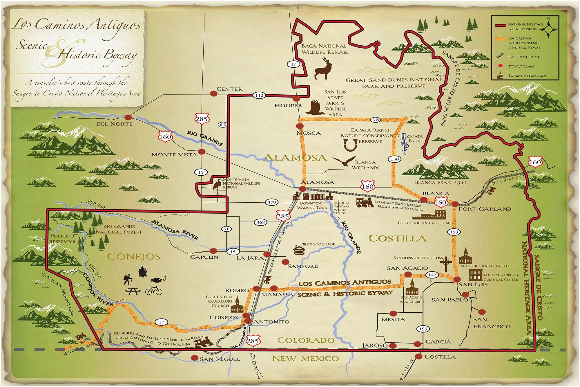
ITH support from the lobbying efforts of The Alliance of National Heritage Areas and good old-fashioned letter writing and phone calling to congressional members, the U.S. House followed up on what the U.S. Senate sent over and signed off Thursday evening on the heritage area’s reauthorization.
Listen HERE to SdCNHA Board member, writer and Valley historian Herman Martinez on The Valley Pod.
“I am extremely proud to be a part of the ANHA! It’s definitely been a roller-coaster ride!!!,” Chacon emailed.
“We received tons of letters, emails, and calls of support from our elected officials, partners, and locals to submit to Congress.”
The legislation funds Colorado’s three national heritage areas through September 2036, provided of course that Congress finds a way each year to adopt a federal budget. It was this congressional session’s roller coaster ride of adopting an omnibus bill that gave Chacon and others who were following the reauthorization process a taste of how the wheels of federal bureaucracy turn.
“For months, the bill was being sent back and forth between the House and Senate with markups and amendments. Tons of strategic meetings and calls were taking place,” Chacon said in describing the experience. “We kept getting tabled to the next session. After Thanksgiving, our bill had still not passed, and we knew it had to be approved by the end of December, or we would have to start all over. It was now or never!”
Now won, and the Sangre de Cristo National Heritage Area – the birthplace of Colorado – can continue to showcase its story.
Click the link to read the release on the Colorado State University website (Jayme DeLoss):
Researchers in Colorado State University’s Department of Atmospheric Science have developed a tool for predicting heavy rainfall that is now used daily by the Weather Prediction Center, part of the National Weather Service.

By working with the Weather Prediction Center over the past several years, Associate Professor Russ Schumacher and his group were able to tailor the tool to suit forecasters’ needs.
A concept-to-operations success story
Excessive rainfall is difficult to forecast, and Weather Prediction Center forecasters needed a tool to help them generate Excessive Rainfall Outlooks, which are issued for the contiguous United States one to three days in advance. These outlooks predict the probability for rainfall that may lead to flash flooding, so they are important for alerting people in harm’s way.
WPC forecasters examine many different data sources in creating Excessive Rainfall Outlooks, and the number of data sources have multiplied in recent decades. Given the tight turnaround, WPC meteorologists were interested in a tool that could synthesize at least some of the data and give them a reasonable starting point.
Enter machine learning plus atmospheric science Ph.D. student Greg Herman, whose undergraduate background included computer science and meteorology. Computers are good at quickly filtering huge datasets into a comprehensible output, and Herman and Schumacher harnessed that strength for the Colorado State University Machine Learning Probabilities system.
“The CSU-MLP prediction system provided the first such forecast, and represents the first machine-learning tool incorporated into WPC’s operations,” said Mark Klein, the Weather Prediction Center’s Science and Operations Officer. “Its forecasts have proven very skillful when compared to observations, and thus it has become a critical tool for our meteorologists.”
NOAA’s reforecasts, retrospective forecasts run with today’s improved numerical models, made it possible for Herman and Schumacher to train their machine-learning model using a consistent dataset. The CSU-MLP algorithm searches historical data from the reforecasts and rainfall record for conditions similar to the current weather forecast. It is able to quickly determine whether those conditions led to heavy rain.
The machine-learning model calculates the probability for heavy rain across the entire U.S., and it has adapted over time based on regional differences.
Herman and Schumacher first presented the tool to a testbed, the annual Flash Flood and Intense Rainfall experiment, in 2017. Based on user feedback from the testbed and WPC forecasters, they fine-tuned the model until it was ready for operations in late 2019. Schumacher’s group continued to work with forecasters to make improvements and released an update in 2020.
“Transitioning research work to operations at NWS is difficult; this project is one of few success stories,” Klein said. “Russ’ group has proven to be one of the best collaborators in academia that WPC has worked with.”
The forecast model is intended to make forecasters’ jobs easier by giving them a starting point to build on with their expertise and meteorological knowledge of the area.
“I’m really proud of the work my group and our partners at WPC have done on this,” said Schumacher, who is also Colorado’s state climatologist and director of the Colorado Climate Center. “It’s really satisfying to see a project go from the research idea all the way to the end product that you know somebody’s looking at every day.”
How much rain is ‘excessive’?
One challenge to forecasting excessive rain is defining what that means for a given area. A few inches of rain can be a bigger deal in Colorado than Louisiana, for example.
Forecasters go by how unusual the amount is for that area and whether it will cause flooding, which is also difficult to predict because terrain is an important factor. The same amount of rain will impact a burn scar very differently than a field.
“We’ve used average recurrence intervals as our definition of excessive rain,” Schumacher said. “Does this amount of rain typically occur at this particular location once a year, twice a year, and so on. That helps to identify how unusual the rainfall is for that area.”
Schumacher’s group has adjusted the threshold for excessive rain to make their model more accurate for specific areas, but there’s still no consensus on what constitutes excessive rain.
“The heavier the rain is, the more difficult it is to forecast in general,” he said.
With a warmer climate expected to bring more heavy rain because warmer air can hold more water vapor, the CSU-MLP tool will be useful in predicting the extreme flooding that will follow.
Schumacher’s group, including research scientist Aaron Hill, recently received funding to work on extending the CSU-MLP system’s forecast range to four to eight days. They also are collaborating with the Storm Prediction Center to apply the CSU-MLP system to other types of hazardous weather, including tornadoes, hail and damaging winds.
Development of the CSU-MLP system was funded by NOAA’s Joint Technology Transfer Initiative. Schumacher and his colleagues wrote about this model and collaboration in the paper, “From Random Forests to Flood Forecasts: A Research to Operations Success Story,” published in the Bulletin of the AMS. Herman graduated from CSU with his Ph.D. in 2018 and now works as a research scientist for Amazon.com.

by Abrahm Lustgarten
ProPublica is a Pulitzer Prize-winning investigative newsroom. Sign up for The Big Story newsletter to receive stories like this one in your inbox.
Series: Killing the Colorado
On a crisp day this fall I drove southeast from Grand Junction, Colorado, into the Uncompahgre Valley, a rich basin of row crops and hayfields. A snow line hung like a bowl cut around the upper cliffs of the Grand Mesa, while in the valley some farmers were taking their last deliveries of water, sowing winter wheat and onions. I turned south at the farm town of Delta onto Route 348, a shoulder-less two-lane road lined with irrigation ditches and dent corn still hanging crisp on their browned stalks. The road crossed the Uncompahgre River, and it was thin, nearly dry.
The Uncompahgre Valley, stretching 34 miles from Delta through the town of Montrose, is, and always has been, an arid place. Most of the water comes from the Gunnison River, a major tributary of the Colorado, which courses out of the peaks of the Elk Range through the cavernous and sun-starved depths of the Black Canyon, one rocky and inaccessible valley to the east. In 1903, the federal government backed a plan hatched by Uncompahgre farmers to breach the ridge with an enormous tunnel and then in the 1960s to build one of Colorado’s largest reservoirs above the Black Canyon called Blue Mesa. Now that tunnel feeds a neural system of water: 782 miles worth of successively smaller canals and then dirt ditches, laterals and drains that turn 83,000 Western Colorado acres into farmland. Today, the farm association in this valley is one of the largest single users of Colorado River water outside of California.
I came to this place because the Colorado River system is in a state of collapse. It is a collapse hastened by climate change but also a crisis of management. In 1922, the seven states in the river basin signed a compact splitting the Colorado equally between its upper and lower halves; later, they promised additional water to Mexico, too. Near the middle, they put Lake Powell, a reserve for the northern states, and Lake Mead, a storage node for the south. Over time, as an overheating environment has collided with overuse, the lower half — primarily Arizona and California — has taken its water as if everything were normal, straining both the logic and the legal interpretations of the compact. They have also drawn extra releases from Lake Powell, effectively borrowing straight out of whatever meager reserves the Upper Basin has managed to save there.
This much has become a matter of great, vitriolic dispute. What is undeniable is that the river flows as a much-diminished version of its historical might. When the original compact gave each half the rights to 7.5 million acre-feet of water, the river is estimated to have flowed with as much as 18 million acre-feet each year. Over the 20th century, it averaged closer to 15. Over the past two decades, the flow has dropped to a little more than 12. In recent years, it has trickled at times with as little as 8.5. All the while the Lower Basin deliveries have remained roughly the same. And those reservoirs? They are fast becoming obsolete. Now the states must finally face the consequential question of which regions will make their sacrifice first. There are few places that reveal how difficult it will be to arrive at an answer than the Western Slope of Colorado.
In Montrose, I found the manager of the Uncompahgre Valley Water Users Association, Steve Pope, in his office atop the squeaky stairs of the same Foursquare that the group had built at the turn of the last century. Pope, bald, with a trimmed white beard, sat amid stacks of plat maps and paper diagrams of the canals, surrounded by LCD screens with spreadsheets marking volumes of water and their destinations. On the wall, a historic map showed the farms, wedged between the Uncompahgre River and where it joins the Gunnison in Delta, before descending to their confluence with the Colorado in Grand Junction. “I’m sorry for the mess,” he said, plowing loose papers aside.

What Pope wanted to impress upon me most despite the enormousness of the infrastructure all around the valley was that in the Upper Basin of the Colorado River system, there are no mammoth dams that can simply be opened to meter out a steady release of water. Here, only natural precipitation and temperature dictate how much is available. Conservation isn’t a management decision, he said. It was forced upon them by the hydrological conditions of the moment. The average amount of water flowing in the system has dropped by nearly 20%. The snowpack melts and evaporates faster than it used to, and the rainfall is unpredictable. In fact, the Colorado River District, an influential water conservancy for the western part of the state, had described its negotiating position with the Lower Basin states by claiming Colorado has already conserved about 28% of its water by making do with the recent conditions brought by drought.
You get what you get, Pope tells me, and for 15 of the past 20 years, unlike the farmers in California and Arizona, the people in this valley have gotten less than what they are due. “We don’t have that luxury of just making a phone call and having water show up,” he said, not veiling his contempt for the Lower Basin states’ reliance on lakes Mead and Powell. “We’ve not been insulated from this climate change by having a big reservoir above our heads.”
He didn’t have to point further back than the previous winter. In 2021, the rain and snow fell heavily across the Rocky Mountains and the plateau of the Grand Mesa, almost as if it were normal times. Precipitation was 80% of average — not bad in the midst of an epochal drought. But little made it into the Colorado River. Instead, soils parched by the lack of rain and rising temperatures soaked up every ounce of moisture. By the time water reached the rivers around Montrose and then the gauges above Lake Powell, the flow was less than 30% of normal. The Upper Basin states used just 3.5 million acre-feet last year, less than half their legal right under the 1922 compact. The Lower Basin states took nearly their full amount, 7 million acre-feet.

All of this matters now not just because the river, an unwieldy network of human-controlled plumbing, is approaching a threshold where it could become inoperable, but because much of the recent legal basis for the system is about to dissolve. In 2026, the Interim Guidelines the states rely on, a Drought Contingency Plan and agreements with Mexico will all expire. At the very least, this will require new agreements. It also demands a new way of thinking that matches the reality of the heating climate and the scale of human need. But before that can happen, the states will need to restore something that has become even more scarce than the water: trust.
The northern states see California and Arizona reveling in profligate use, made possible by the anachronistic rules of the compact that effectively promise them water when others have none. It’s enabled by the mechanistic controls at the Hoover Dam, which releases the same steady flow no matter how little snow falls across the Rocky Mountains. California flood-irrigates alfalfa crops destined for cattle markets in the Middle East, while Arizona takes water it does not need and pumps it underground to build up its own reserves. In 2018, an Arizona water agency admitted it was gaming the timing of its orders to avoid rations from the river (though it characterized the moves as smart use of the rules). In 2021, in a sign of the growing wariness, at least one Colorado water official alleged California was repeating the scheme. California water officials say this is a misunderstanding. Yet to this day, because California holds the most senior legal rights on the river, the state has avoided having a single gallon of reductions imposed on it.

By this spring, Lake Powell shrank to 24% of its capacity, its lowest levels since the reservoir filled in the 1960s. Cathedral-like sandstone canyons were resurrected, and sunlight reached the silt-clogged floors for the first time in generations. The Glen Canyon Dam itself towered more than 150 feet above the waterline. The water was just a few dozen feet above the last intake pipe that feeds the hydropower generators. If it dropped much lower, the system would no longer be able to produce the power it distributes across six states. After that, it would approach the point where no water at all could flow into the Grand Canyon and further downstream. All the savings that the Upper Basin states had banked there were as good as gone.
In Western Colorado, meanwhile, people have been suffering. South of the Uncompahgre Valley, the Ute Mountain Ute tribe subsists off agriculture, but over the past 12 months it has seen its water deliveries cut by 90%; the tribe laid off half of its farmworkers. McPhee Reservoir, near the town of Cortez, has teetered on failure, and other communities in Southwestern Colorado that also depend on it have been rationed to 10% of their normal water.
Across the Upper Basin, the small reservoirs that provide the region’s only buffer against bad years are also emptying out. Flaming Gorge, on the Wyoming-Utah border, is the largest, and it is 68% full. The second largest, Navajo Reservoir in New Mexico, is at 50% of its capacity. Blue Mesa Reservoir, on the Gunnison, is just 34% full. Each represents savings accounts that have been slowly pilfered to supplement Lake Powell as it declines, preserving the federal government’s ability to generate power there and obscuring the scope of the losses. Last summer, facing the latest emergency at the Glen Canyon Dam, the Department of Interior ordered huge releases from Flaming Gorge, Blue Mesa and other Upper Basin reservoirs. At Blue Mesa, the water levels dropped 8 feet in a matter of days, and boaters there were given a little more than a week to get their equipment off the water. Soon after, the reservoir’s marinas, which are vital to that part of Colorado’s summer economy, closed. They did not reopen in 2022.
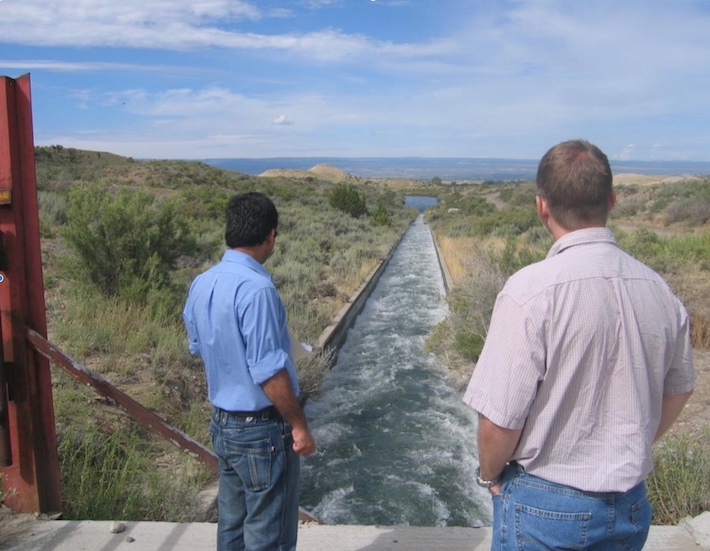
As the Blue Mesa Reservoir was being emptied last fall, Steve Pope kept the Gunnison Tunnel open at its full capacity, diverting as much water as he possibly could. He says this was legal, well within his water rights and normal practice, and the state’s chief engineer agrees. Pope’s water is accounted for out of another reservoir higher in the system. But in the twin takings, it’s hard not to see the bare-knuckled competition between urgent needs. Over the past few years, as water has become scarcer and conservation more important, Uncompahgre Valley water diversions from the Gunnison River have remained steady and at times even increased. The growing season has gotten longer and the alternative sources, including the Uncompahgre River, less reliable. And Pope leans more than ever on the Gunnison to maintain his 3,500 shareholders’ supply. “Oh, we are taking it,” he told me, “and there’s still just not enough.”
On June 14, Camille Touton, the commissioner of the U.S. Bureau of Reclamation, the Department of Interior division that runs Western water infrastructure, testified before the Senate Committee on Energy and Natural Resources and delivered a stunning ultimatum: Western states had 60 days to figure out how to conserve as much as 4 million acre-feet of “additional” water from the Colorado River or the federal government would, acting unilaterally, do it for them. The West’s system of water rights, which guarantees the greatest amount of water to the settlers who arrived in the West and claimed it first, has been a sacrosanct pillar of law and states’ rights both — and so her statement came as a shock.
Would the department impose restrictions “without regard to river priority?” Mark Kelly,, the Democratic senator from Arizona, asked her.
“Yes,” Touton responded.
For Colorado, this was tantamount to a declaration of war. “The feds have no ability to restrict our state decree and privately owned ditches,” the general manager of the Colorado River District, Andy Mueller, told me. “They can’t go after that.” Mueller watches over much of the state.Pope faces different stakes. His system depends on the tunnel, a federal project, and his water rights are technically leased from the Bureau of Reclamation, too. Touton’s threat raised the possibility that she could shut the Uncompahgre Valley’s water off. Even if it was legal, the demands seemed fundamentally unfair to Pope. “The first steps need to come in the Lower Basin,” he insisted.
Each state retreated to its corners, where they remain. The 60-day deadline came and went, with no commitments toward any specific reductions in water use and no consequences. The Bureau of Reclamation has since set a new deadline: Jan. 31. Touton, who has publicly said little since her testimony to Congress, declined to be interviewed for this story. In October, California finally offered a plan to surrender roughly 9% of the water it used, albeit with expensive conditions. Some Colorado officials dismissed the gesture as a non-starter. Ever since, Colorado has become more defiant, enacting policies that seem aimed at defending the water the state already has — perhaps even its right to use more.
For one, Colorado has long had to contend with the inefficiencies that come with a “use it or lose it” culture. State water law threatens to confiscate water rights that don’t get utilized, so landowners have long maximized the water they put on their fields just to prove up their long-term standing in the system. This same reflexive instinct is now evident among policymakers and water managers across the state, as they seek to establish the baseline for where negotiated cuts might begin. Would cuts be imposed by the federal government based on Pope’s full allocation of water or on the lesser amount with which he’s been forced to make do? Would the proportion be adjusted down in a year with no snow? “We don’t have a starting point,” he told me. And so the higher the use now, the more affordable the conservation later.
Colorado and other Upper Basin states have also long hid behind the complexity of accurately accounting for their water among infinite tributaries and interconnected soils. [ed. emphasis mine] The state’s ranchers like to say their water is recycled five times over, because water poured over fields in one place invariably seeps underground down to the next. In the Uncompahgre Valley, it can take months for the land at its tail to dry out after ditches that flood the head of the valley are turned off. The measure of what’s been consumed and what has transpired from plants or been absorbed by soils is frustratingly elusive. That, too, leaves the final number open to argument and interpretation.
All the while, the Upper Basin states are all attempting to store more water within their boundaries. Colorado has at least 10 new dams and reservoirs either being built or planned. Across the Upper Basin, an additional 15 projects are being considered, including Utah’s audacious $2.4 billion plan to run a new pipeline from Lake Powell, which would allow it to transport something closer to its full legal right to Colorado River water to its growing southern cities. Some of these projects are aimed at securing existing water and making its timing more predictable. But they are also part of the Upper Colorado River Commission’s vision to expand the Upper Basin states’ Colorado River usage to 5.4 million acre-feet a year by 2060.
It is fair to say few people in the state are trying hard to send more of their water downstream. In our conversation, Mueller would not offer any specific conservation savings Colorado might make. The state’s chief engineer and director of its Division of Water Resources, Kevin Rein, who oversees water rights, made a similar sentiment clear to the Colorado River District board last July. “There’s nothing telling me that I should encourage people to conserve,” Rein said. “It’s a public resource. It’s a property right. It’s part of our economy.”
In November, Democratic Gov. Jared Polis proposed the creation of a new state task force that would help him capture every drop of water it can before it crosses the state line. It would direct money and staff to make Colorado’s water governance more sophisticated, defensive and influential.
I called Polis’ chief water confidante, Rebecca Mitchell, who is also the director of the Colorado Water Conservation Board and the state’s representative on the Upper Colorado River Commission. If the mood was set by the idea that California was taking too much from the river, Mitchell thought that it had shifted now to a more personal grievance — they are taking from us.

Last month, Mitchell flew to California for a tour of its large irrigation districts. She stood beside a wide canal brimming with more water than ever flows through the Uncompahgre River, and the executive of the farming company beside her explained that he uses whatever he wants because he holds the highest priority rights to the water. She thought about the Ute Mountain Ute communities and the ranchers of Cortez: “It was like: ‘Wouldn’t we love to be able to count on something? Wouldn’t we love to be feel so entitled that no matter what, we get what we get?’” she told me.
What if Touton followed through, curtailing Colorado’s water? I asked. Mitchell’s voice steadied, and then she essentially leveled a threat. “We would be very responsive. I’m not saying that in a positive way,” she said. “I think everybody that’s about to go through pain wants others to feel pain also.”
Here’s the terrible truth: There is no such thing as a return to normal on the Colorado River, or to anything that resembles the volumes of water its users are accustomed to taking from it. With each degree Celsius of warming to come, modelers estimate that the river’s flow will decrease further, by an additional 9%. At current rates of global warming, the basin is likely to sustain at least an additional 18% drop in its water supplies over the next several decades, if not far more. Pain, as Mitchell puts it, is inevitable.
The thing about 4 million acre-feet of cuts is that it’s merely the amount already gone, an adjustment that should have been made 20 years ago. Colorado’s argument makes sense on paper and perhaps through the lens of fairness. But the motivation behind the decades of delay was to protect against the very argument that is unfolding now — that the reductions should be split equally, and that they may one day be imposed against the Upper Basin’s will. It was to preserve the northern states’ inalienable birthright to growth, the promise made to them 100 years ago. At some point, though, circumstances change, and a century-old promise, unfulfilled, might no longer be worth much at all. Meanwhile, the politics of holding out are colliding with climate change in a terrifying crash, because while the parties fight, the supply continues to dwindle.
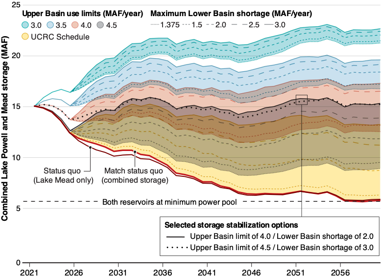
Recently, Brad Udall, a leading and longtime analyst of the Colorado River and now a senior water and climate scientist at Colorado State University, teamed with colleagues to game out what they thought it would take to bring the river and the twin reservoirs of Mead and Powell into balance. Their findings, published in July in the journal Science, show that stability could be within reach but will require sacrifice.
If the Upper Basin states limited their claim to 4 million acre-feet, or 53% of their due under the original compact, and the Lower Basin states and Mexico increased their maximum emergency cuts by an additional 45%, the two big reservoirs will stay at roughly their current levels for the next several decades. If the basins could commit to massive reductions below even 2021 levels for the Upper Basin and to more than doubling the most ambitious conservation goals for the south, the reservoirs could once again begin to grow, providing the emergency buffer and the promise of economic stability for 40 million Americans that was originally intended. Still, by 2060, they would only be approximately 45% full.
Any of the scenarios involve cuts that would slice to the bone. Plus, there’s still the enormous challenge of how to incorporate Native tribes, which also hold huge water rights but continue to be largely left out of negotiations. What to do next? Israel provides one compelling example. After decades of fighting over the meager trickles of the Jordan River and the oversubscription of a pipeline from the Sea of Galilee, Israel went back to the drawing board on its irrigated crops. It made drip irrigation standard, built desalination plants to supply water for its industry and cities, and reused that water again and again; today, 86% of the country’s municipal wastewater is recycled, and Israel and its farmers have an adequate supply. That would cost a lot across the scale and reach of a region like the Western United States. But to save the infrastructure and culture that produces 80% of this country’s winter vegetables and is a hub of the nation’s food system for 333 million people? It might be worth it.
A different course was charted by Australia, which recoiled against a devastating millennium drought that ended 13 years ago. It jettisoned its coveted system of water rights, breaking free of history and prior appropriation similar to the system of first-come-first-served the American West relies on. That left it with a large pool of free water and political room to invent a new method of allocating it that better matched the needs in a modern, more populous and more urban Australia and better matched the reality of the environment.
In America, too, prior appropriation, as legally and culturally revered as it is, may have become more cumbersome and obstructive than it needs to be. Western water rights, according to Newsha Ajami, a leading expert at Lawrence Berkeley National Laboratory and the former director of the urban water policy program at Stanford University, were set up by people measuring with sticks and buckets, long before anyone had ever even considered climate change. Today, they largely serve powerful legacy interests and, because they must be used to be maintained, tend to dissuade conservation. “It’s kind of very archaic,” she said. “The water rights system would be the first thing I would just dismantle or revisit in a very different way.”
This is probably not going to happen, Ajami said. “It could be seen as political suicide.” But that doesn’t make it the wrong solution. In fact, what’s best for the Colorado, for the Western United States, for the whole country might be a combination of what Israel and Australia mapped out. Deploy the full extent of the technology that is available to eliminate waste and maximize efficiency. Prioritize which crops and uses are “beneficial” in a way that attaches the true value of the resource to the societal benefit produced from using it. Grow California and Arizona’s crops in the wintertime but not in the summer heat. And rewrite the system of water allocation as equitably as possible so that it ensures the modern population of the West has the resources it needs while the nation’s growers produce what they can.
What would that look like in Colorado? It might turn the system upside down. Lawsuits could fly. The biggest, wealthiest ranches with the oldest water rights stand to lose a lot. The Lower and Upper Basin states, though, could all divide the water in the river proportionately, each taking a percentage of what flowed. The users would, if not benefit, at least equally and predictably share the misery. Pope’s irrigation district and the smallholder farmers who depend on it would likely get something closer to what they need and, combined with new irrigation equipment subsidized by the government, could produce what they want. It wouldn’t be pretty. But something there would survive.
The alternative is worse. The water goes away or gets bought up or both. The land of Western Colorado dries up, and the economies around it shrivel. Montrose, with little left to offer, boards up its windows, consolidates its schools as people move away, and the few who remain have less. Until one day, there is nothing left at all.
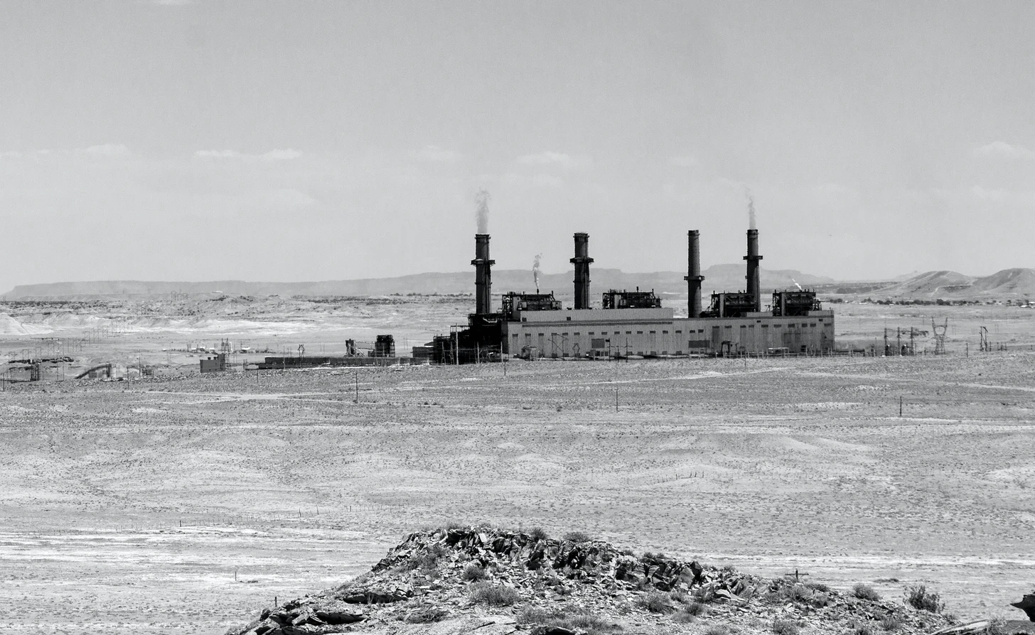
Click the link to read the article on The Farmington Daily Times website (John R. Moses). Here’s an excerpt:
The City of Farmington announced it has ended the plan it began years ago to acquire the San Juan Generating Station and run it with a partner.
The announcement Dec. 20 followed a loss during arbitration hearings Dec. 14 that the city called a “catastrophic blow” to the partnership between it and Enchant Energy.
Farmington Mayor Nate Duckett said a strategy employed by Public Service Company of New Mexico (PNM) and other plant owners to dismantle key parts of the facility during decommissioning work got the go-ahead from a panel of arbitrators – a panel the city had hoped would instead put a hold on equipment auctions.
“Given PNM’s and the other co-owners’ actions to quickly dismantle SJGS, and the panel’s recent decision to allow them to do so, we have arrived at a point where those actions directly undermine the viability of successful implementation of the Carbon Capture Project,” Duckett said in the press release issued by the city Tuesday afternoon.
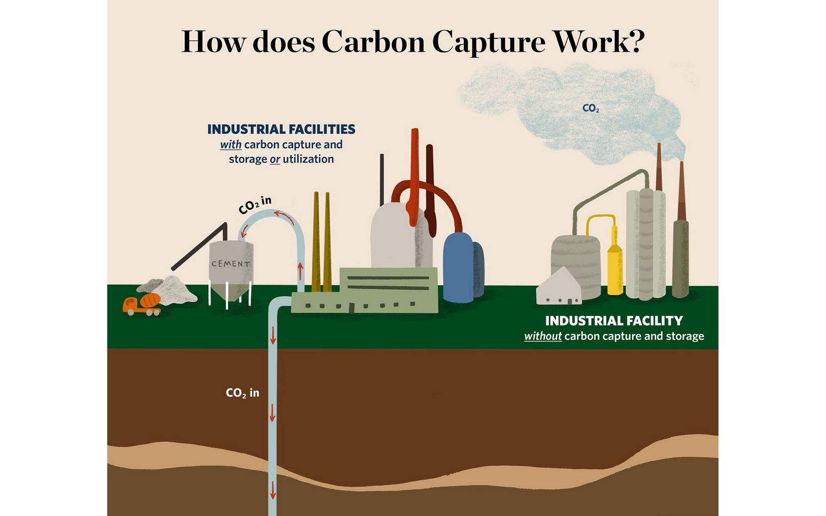

Click the link to read the article on the Big Pivots website (Allen Best):
Colorado in the late 1970s had a convergence of people who thought there had to be another way to power a civilization. Among them were the founders of the Colorado Renewable Energy Society.
Cleve Simpson was one of two state legislators who attended the Colorado Renewable Energy Society’s annual conference in 2022. The reason was not immediately obvious.
The second legislator was scheduled to receive an award that afternoon at the sunshine-dappled Unitarian Church between Golden and Wheat Ridge. But why was Simpson, a Republican who represents the San Luis Valley as well as southwestern Colorado, there to hear about microgrids, agrivoltaics, and other presentations?
Since its founding in 1996, the Colorado Renewable Energy Society has been a fount of educational programming about solar, wind, and other subjects related to energy.
The organization has often provided grassroots and sometimes grasstops—some members are unusually well connected—advocacy for taking steps to achieve this deepening penetration.
Simpson, a graduate of the Colorado School of Mines, is listed on the General Assembly website as being a “farmer/rancher.” That description falls short of his resume. He was a mining engineer who worked 20 years in the lignite coal fields of Texas as well as in Australia before returning to his roots. He’s a fourth-generation farmer in the San Luis Valley.
And farming in the San Luis Valley has a very fundamental challenge. Current levels of water extraction cannot be sustained. Land must necessarily be trimmed from production. Simpson attended the CRES conference, he confided later, because he was interested in how renewable energy–solar, in particular–can leave his farming-based communities economically whole. He was at the meeting to inform himself for his work as a state legislator but also as director of the Rio Grande Water Conservancy District, the agency that must oversee those cuts in water.

Just how the CRES conference may influence Simpson in his duties as a state legislator cannot be said. Only occasionally can dots be directly connected. But he was there, listening intently.
That has been the role of CRES from its founding in Golden during a time when solar was still expensive and the near-term risks of climate change not as clearly defined. It has been, first and foremost, an educational forum, but also a place for people focused on renewable energy to connect and sometimes take direct action, as in advocacy on behalf of the nation’s first voter-initiated renewable energy mandate. At times, CRES has also articulated visions that have resulted in the bills considered and then passed by state legislators.
Many of the challenges that 25 years ago seemed so imposing have now been surmounted. Renewable energy has become the first, not the last, option in electrical generation.
Has CRES outlived its purpose? Certainly not. If old arguments against renewables about cost and integration have been dismantled, renewables must still be scaled even more rapidly than has now occurred if the worst of climate change impacts are to be avoided. There are questions about the impediments to transmission and the proper role of large and central renewables vs. local renewable resources such as rooftop solar. There are questions about the role of storage and its formats, the role of nuclear—if any, and how agriculture can be integrated into decarbonization.
Too, the atmospheric situation has deteriorated so rapidly that the question of mechanisms to draw carbon dioxide from the sky has become legitimate.
Colorado is well on its way to achieving penetration of renewables that was unimaginable even a decade ago. That summit is within sight. But beyond lie many other mountains yet to be climbed. No, CRES has not outlived its purpose.
Coming together of minds
Colorado was a logical place for solar supporters to gather. The state’s 300 days of sunshine is a cliché that happens to be true. It ranks sixth among the 50 states in average annual sunlight.
The National Renewable Energy Laboratory also played a major role ithe creation of CRES. The laboratory was established in 1977 as the Solar Energy Research Institute, or SERI, whose second director was Denis Hayes. As president of the student body at Stanford University in 1970, Hayes helped organize the first Earth Day.
Creation of SERI brought others to Colorado who then figure into the creation of CRES and, more broadly, Colorado’s emergence as a national leader. One of them was Ron Larson, a figure with deep and continuous presence in CRES since its founding in 1996.
In 1972, though, Larson was a young professor of electrical engineering in Atlanta at Georgia Tech who focused on a narrow component of electromagnetics with implications for capabilities of the U.S. military.
Larson wanted more, to scratch a career itch. He applied and was then chosen to represent IEEE, the professional engineering and technology association, as a Congressional fellow. He planned to return to Georgia after a year in Washington. He did not. Something happened during his first week in Washington that profoundly altered his career path—and that of the nation. Arab oil producing states in the Mideast announced an embargo of exports to the United States.
Priorities in Washington shifted dramatically. Larson went to work for the House Science Committee, where he was assigned to work on two solar bills.
Solar photovoltaics, which now has capacity to generate electricity for less than $1 a watt, with prices still descending, then cost 100 times as much. That expense limited its use primarily to exploration of space. The federal budget for research was small, just $4 million to $5 million, but there was strong, bipartisan enthusiasm to pursue solar research. The oil embargo fueled even greater interest, mostly in solar heating for space and water.
“Barry Goldwater wanted solar energy,” says Larson, referring to the U.S. senator from Arizona who was also the 1964 Republican presidential candidate. “Renewable energy then was bipartisan. Everybody was for it.”
A law quickly passed in 1974 authorized creation of SERI. Golden, Colorado was chosen for the site. With a position secured at the laboratory, Larson and his wife, Gretchen, arrived July 5, 1977.
When the Larsons arrived, another young man in Colorado was already devoted to advancing use of solar energy. Morey Wolfson had been a graduate student at the University of Colorado in 1970 when he organized the nation’s third-largest Earth Day celebration. Soon after he set out to learn what was known about solar energy. The Denver Public Library had 35 books on squirrels, he discovered, but just one book on solar. That book had been checked out just once in the six years after being published in 1964.
The takeaway conclusion of that book, “Direct Use of the Sun’s Energy,” by Farrington Daniels, was that there “was no technical reason why direct use of the sun’s energy cannot be the basis for the energy needs of an advanced economy.” [ed. emphasis mine]
From 1973 to 1983, Wolfson operated the Solar Bookstore in Denver at Colfax Avenue and York Street. The store was devoted to renewable energy, and the mail-order business patronized by architects and others kept it afloat, if barely. Wolfson also helped found various environmental groups in Denver before closing the bookstore and joining the staff of the Colorado Public Utilities Commission in 1985. At the PUC, among other assignments, Wolfson was executive assistant to the three commissioners.
Among the commissioners was Ron Lehr, an important figure in Colorado’s energy transition. Lehr’s first glimpse of the issues with which he has been engaged occurred in 1965 when his sister and a friend rafted down the soon-to-be submerged Glen Canyon in southern Utah. She was outraged at the imminent sacrifice of such a beautiful canyon, which the Sierra Club had been working to preserve. The club’s position included the argument that the hydroelectric production from Glen Canyon Dam was unneeded because coal was plentiful on the nearby Kaiparowits Plateau. “It’s important to be humble over time,” Lehr observes wryly.
In 1976, the writings of Amory Lovins, a MacArthur Genius Award prize-winner, captivated Lehr. Reacting to the oil embargo had inspired Lovins to fundamentally rethink the energy equation to include demand as well as supply. His 1976 essay in Foreign Affairs, “Energy Strategy: The Road Not Taken,” changed energy debates permanently.
The path Lovins advocated “combines a prompt and serious commitment to efficient use of energy, rapid development of renewable energy sources matched in scale and in energy quality to end-use needs, and special transitional fossil-fuel technologies. This path, a whole greater than the sum of its parts, diverges radically from incremental past practices to pursue long-term goals.”
The message from Lovins, then revolutionary, today remains profound in its implications. “You read it and the world shifts,” says Lehr of Lovins’s essay. “Thinking about energy could never be the same.”
Lehr downplays his contributions since then. Others say he has been a pivotal figure.“I just happened to be standing there,” he says. “My life has been like that. I have been close to those insights and have been able to pick them up and repeat them and help to make change happen.”
The Colorado in which Denver natives Lehr and Wolfson came of age and to which Larson arrived in the 1970s was blessed– some would say cursed–with fossil fuels of all kinds. It had hydrocarbons in various chemical forms and geological settings, along with methane and coal. Too, it was proximate to the vast inland sea of hydrocarbons in Wyoming and Montana called the Powder River Basin. But it also had outstanding wind and solar resources and intellectual capital.
As Colorado’s population between 1960 and 1980 expanded from 1.8 million to 2.9 million, demand for electricity grew even more robustly. Utilities responded with ever-larger coal-burning plants, the last (until Comanche 3 in 2010) completed in 1984. Coal was cheap, the pollution it produced accepted as a cost of progress as it had been since the start of the Industrial Revolution.
As for solar – well, it was the stuff for space missions, not for earthly tasks. Or so went the conventional logic.
Telling was the fate of the institute that had drawn Larson to Colorado. After Ronald Reagan became president in 1981, he dismantled the solar panels on the White House that his predecessor, Jimmy Carter, had erected. Carter had also traveled to Colorado in 1978 to dedicate the new solar energy research institute. Reagan’s administration three years later slashed the budget from $130 million to $50 million.
The solar research didn’t cease, but it slowed through the Reagan years.
Hayes, the director, told Rolling Stone magazine’s Jeff Goodell in a 2020 interview that the day he got that news was the most horrible day of his life. “It was harder than the days my parents died,” he said. “I spent much of the next year writing letters of recommendation for people, many of whom I had lured out to this thing, and then they suddenly had their lives shattered.”
Steve Andrews was among the contractors who was let go. He remembers well the remarks of Hayes in announcing the news. Hayes called the Department of Energy administrators “dull gray men in dull gray suits thinking dull, gray thoughts.” Instead of taking a scalpel to the skin, he added, the Department of Energy had taken a meat-ax to the muscle of the SERI staff.
“My recollection is that after those remarks, he was required to leave the building a few hours sooner than had been planned,” say Andrews. “The DOE dudes didn’t want more scorched earth salvos delivered by Denis.”
Larson also left. His next career move was to Khartoum, in the African country of Sudan, on an assignment by Georgia Tech as part of a U.S. Administration for International Development mission. Later, he returned to Golden but never to Georgia.
The birth of CRES
CRES was preceded by several grassroots organizations in the Denver area with the same general mission.
The Denver Solar Energy Society, which was later reorganized as the Denver Energy Resource Center, was similar to CRES in that it had monthly educational meetings. It even had paid staff for a time as interest surged in solar during the early 1980s because of federal tax credits adopted in 1977. As many as 400 people attended meetings. Tours of solar homes were conducted, aided by 40-page brochures.
Then, in 1985, federal tax credits expired. Solar enthusiasm vanished.
A national advocacy group, the American Solar Energy Society, or ASES, obviously saw a more prominent role for solar, as did those working at the laboratory in Golden that had been defunded. By 1991, the tide had turned again. President George H.W. Bush visited Golden that year to mark the designation of the solar laboratory as a national laboratory with a broader mission. It became NREL.
Larson says CRES was launched at the instigation of ASES, using funds inherited from the then-defunct Denver solar organization. In its very earliest years, it had a huge crossover in membership with NREL employees. It still has crossover, if not quite as much.
That interplay with NREL was reflected in the initial leadership of H.M. “Hub” Hubbard. He had arrived in Colorado to lead SERI after Hayes was fired.
“Hubbard was a very well-known solar expert in the mid-1990s,” says Larson. “I was behind him in line for dinner and asked him if he would be willing to be chair of CRES, and he said yes. We could not have had a more important person for the first year. In my mind, we might not have been a success without Hubbard.”
Hubbard gave CRES instant credibility and facilitated NREL as the meeting place for several years. Wolfson—who left the PUC in 1999—helped coordinate some of that CRES programming in his new job at NREL. Many of those presenting informational sessions then—and continuing today—were researchers from NREL. Meetings were attended by 20 to 50 people.
Volunteerism was at the core of CRES. Notable was the effort by CRES co-founder Paul Notari, who had been head of the Technical Information Branch at SERI and then NREL. For 14 years he was the publisher and editor of CRES News, a lively newsletter for members from the founding until 2010. Notari was instrumental in early CRES outreach. He identified and contacted almost 500 people in the Denver area who were interested in solar. He wrote news releases and proposed story ideas to local media. In this and other ways, Notari helped knit together disparate individuals and topics into a fluid but somewhat cohesive whole.
Doug Seiter remembers getting involved with the new organization soon after arriving in Colorado in 1997 as an employee of the Department of Energy. Later, he served two terms as president of the board of directors.
“It was the choir, for the most part, people already engaged in the industry or very much interested in doing something in renewable energy,” he says. This collection of like-minded people helped build enthusiasm and coalesce motivation.
Larry Sherwood, the executive director of ASES from 1988 to 2001, concurs that Colorado’s solar conversation in the 1990s revolved around NREL. CRES provided an outlet “for some brilliant minds at NREL to engage in policy or educational types of activities that they were interested in but weren’t part of their research at NREL,” says Sherwood, who would later become a member of the board of directors for several terms. “I think CRES definitely benefitted from those people.”
CRES also has advocacy in its DNA. That was manifested relatively soon after CRES was organized in a case before state utility regulators about a potential wind project in southeastern Colorado. It was likely the first time that the costs of integrating wind into utility operations were decided in a public record.
Coming next:: A team approach by advocates of renewable energy yields a victory when a compelling case is made for a major wind farm in southeastern Colorado.
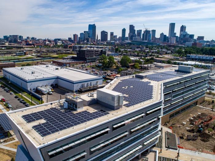

Reclamation’s Ernie Rheaume talks about the Federally recognized Tribes in the Colorado River Basin and how Tribal engagement and consultation are on the forefront of Reclamation’s activities.
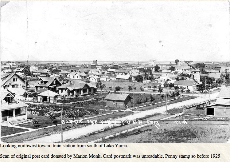
Click the link to read the article on the KUNC website (Rae Solomon). Here’s an excerpt:
“The yields are off,” [Ruben] Richardson explained. “We’re a little bit short of water. This soil – you have to water a bunch every day to maintain it.” He had to use a lot more water in his fields than usual this year, just to produce any crop under drought conditions. That water was delivered by 58 center pivot sprinklers, across Richardson’s fields of irrigated corn and sugar beets. The sprinklers were fed, in turn, by 45 high-capacity wells pumping groundwater out of the Ogallala Aquifer, far below the ground…

Picture a bathtub. But this bathtub has a very rocky, jagged bottom. When you pour in the water, the tub doesn’t fill evenly. Instead, it forms pools of different sizes within the crags and pits of that rocky floor. Now imagine that bathtub is huge: 175,000 square miles huge. It stretches across 8 stations, from South Dakota all the way down to Texas, including parts of eastern Colorado. Also, the whole thing is deep underground. That is the Ogallala Aquifer. A vast, but uneven reserve of freshwater stored under the earth. The people who live on top of the aquifer pump it out of the ground. More than 90 percent of Ogallala water is used for agriculture, and that water transformed the high plains dust bowl of eastern Colorado into highly productive farmland.
But according to Meagan Schipanski, an associate professor at Colorado State University and Co-Director of the Ogallala Water Coordinated Agriculture Project, the aquifer has its limits. The water has been over-allocated for decades. The current drought is exacerbating the shortage. “That water is a nonrenewable resource,” Schipanski said, “we’re going to use it faster than it can recharge itself.”
The hydrology and terrain of the aquifer is highly variable, making it difficult to generalize about just how much water has been depleted. But across northeastern Colorado, on average the aquifer is down about 30% from where it started before groundwater irrigation became widespread in the mid 20th-century.
Click the link to read the article on the NOAA website (BREANNA ZAVADOFF AND MARYBETH ARCODIA):
This is a guest post by Breanna Zavadoff and Marybeth Arcodia. Dr. Zavadoff is an Assistant Scientist at the University of Miami Cooperative Institute for Marine and Atmospheric Studies. Her current research focuses on U.S. West Coast atmospheric rivers as well as subseasonal Madden-Julian Oscillation predictability. Dr. Arcodia is a Postdoctoral Researcher at Colorado State University working in the Barnes Group. Her current research explores sources of climate predictability from subseasonal to decadal timescales using explainable artificial intelligence techniques. She also writes for the Seasoned Chaos blog, a subseasonal to seasonal forecasting blog for scientists and non-scientists alike. The blog was created by five graduate students and features posts on atmospheric and climate phenomena described in fun and digestible ways (some linked in this post), including quality graphics and even some code!
When looking at the forecast on your favorite weather app, it may be hard to imagine that forecast could be connected to atmospheric and ocean conditions all the way across the globe. Fortunately for us, these connections can allow us to make predictions weeks to months in advance. How is this possible?
Buckle up! It’s time to go for a ride on our planet’s information superhighway.

What is a teleconnection?
Teleconnections are significant relationships or links between weather phenomena at widely separated locations on earth, which typically entail climate patterns that span thousands of miles. Many teleconnection patterns behave like a seesaw, with atmospheric mass/pressure shifting back and forth between two distant locations—an increase in, say, atmospheric pressure in one location results in a decrease in pressure somewhere far, far away [1]. There is even evidence of Viking settlers noticing the opposing pressure patterns between Greenland and Europe dating back to ~1000 AD, which today is referred to as the North Atlantic Oscillation (NAO) [2,3].
If you’re thinking to yourself that you’ve seen this teleconnection business before, you are absolutely right! One of the most famous drivers of teleconnection patterns is our good buddy ENSO (perhaps we are a little biased) a.k.a the El Niño/Southern Oscillation. The “Southern Oscillation” refers to changes in sea-level pressures that are centered over the eastern tropical Pacific and over Indonesia (learn more here and here). Followed closely in notoriety is the Pacific-North American pattern, an oscillatory pressure pattern over the Pacific Ocean and North America, which influences North American and European temperature and precipitation.
Rossby waves: the original global delivery service
How do these teleconnections relate to weather patterns around the globe? Let’s move into high gear on atmospheric dynamics! Don’t worry, we won’t throw equations at you. Foundational to teleconnection patterns are large-scale atmospheric waves, specifically Rossby waves, named after the world-renowned meteorologist Carl-Gustaf Rossby. Rossby waves can persist from days to months and can vary from a few hundred miles long to spanning the entire planet! We’re calling the routes that Rossby waves travel “information superhighways,” as the waves carry information that can affect weather along their paths.
What exactly is this information that Rossby waves carry? When you see a wave traveling along the surface of water, there are peaks and troughs in the water height. The same happens in the atmosphere with a traveling Rossby wave – as the Rossby wave travels through the atmosphere, the peaks and troughs of the wave produce regions of high and low air pressure. These resultant pressure patterns, i.e. the “information” carried by Rossby waves, influence temperature, rainfall, wind, etc. In short, Rossby waves are fundamental to teleconnection patterns! (footnote 1)
Where do they come from? Where do they go?
Rossby waves differ a bit from the large waves we are used to seeing in the ocean, which move up and down (vertically). Instead, Rossby waves in the atmosphere travel in the north-south direction (horizontally) due to the Earth rotating faster at the equator than at the poles. This leads to the Coriolis force, which causes moving air parcels to turn to the right as they move away from the equator toward the North Pole, where the effect (i.e., apparent deflection) of the Coriolis force is stronger. These rightward deflections turn the air back towards the equator, then the air is once again redirected back towards the poles as we move higher in latitude (footnote 2). This balancing act of air moving towards the poles and back towards the equator results in the development of an oscillating wave, which is how many planetary Rossby waves are formed (footnote 3).
Atmospheric Rossby waves (footnote 4) exist on time scales from just days to months and can be triggered by air flowing over Earth’s complex geography, like mountain ranges, as well as circulation patterns that arise due to unequal temperature heating (the equator gets more sunlight than the poles). Large regions of towering showers and thunderstorms near the equator, which are related to phenomena like ENSO and the MJO can also be responsible for revving the engine (i.e. triggering) of Rossby waves [4, 5] by disrupting the atmosphere via the heating that occurs when water vapor condenses into clouds. This heating causes rippling waves to form—much like dropping a stone in a lake.
Rossby waves are often rerouted and carried along by the jet streams, which are often considered as “waveguides” for Rossby waves. In other words, the jet streams set up the routes for the Rossby waves to flow through, similar to how a carved path in the sand is where water tends to flow. Whisked along by the jet streams, Rossby waves transport heat and momentum from the tropics toward the poles (south-to-north) and polar air towards the tropics (north-to-south). Thus, the location, strength, and even waviness of the jet stream dictates a substantial portion of the mid-latitude weather, including whether or not Arctic air will be dipping down into your neighborhood.
Rossby waves can be either stationary or transient. While stationary Rossby waves simply undulate over a region, meaning the peaks and troughs of the wave do not change location (like the standing wave in this previous ENSO blog post), transient Rossby waves traverse the globe, traveling west-to-east over thousands of miles. Scientists and forecasters study both types of Rossby waves due to their wide-ranging impacts and use them to predict where and how the weather may change anywhere from a few days to a few months in the future.
Signed, sealed, delivered
When transporting goods from one place to another, one could argue the transport isn’t complete until everything has been unloaded from the vehicle. In other words, it’s not enough to simply get from point A to point B. The same goes for the Rossby waves traveling along our global information superhighway. While all Rossby waves carry important information, some deposit larger signals along their shipping routes than others through a phenomenon called “Rossby wave breaking”. When Rossby waves break (imagine an ocean wave breaking on the beach or a towel folding) information is exchanged from the Rossby waves to the rest of the atmosphere through both the vertical and horizontal mixing of air parcels [6,7], completing the information transfer journey that began thousands of miles away.
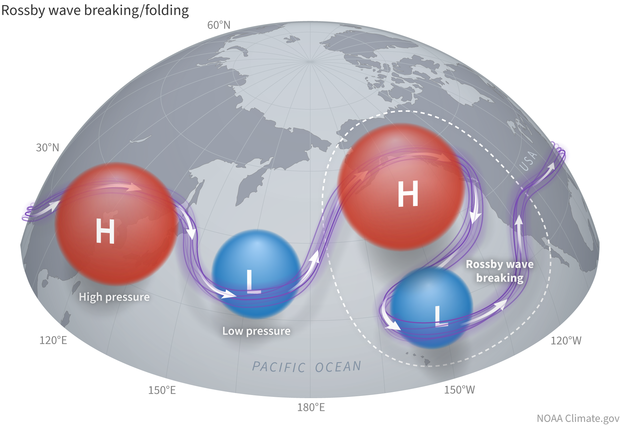
The information transfer facilitated by Rossby wave breaking has been associated with a multitude of phenomena around the globe. In the midlatitudes, breaking Rossby waves have been shown to modulate the phase of the North Atlantic Oscillation, the location of landfalling atmospheric rivers along the western coastlines of the United States and Europe [8,9,10,11] and the onset/dissipation of atmospheric blocking events [12,13,14]. When Rossby waves break more frequently closer to the equator they can also create an unfavorable environment for tropical convection [15,16,17], which serves to induce dry spell episodes in the Indian summer monsoon [18] and reduce the number of tropical cyclones that develop in the North Atlantic [19,20].
The frequency and location of Rossby wave breaking is primarily controlled by the jet stream [21,22], A.K.A. the backbone of the global information superhighway. The jet stream, in turn, is modulated by climate patterns of variability that exist on subseasonal (Madden-Julian Oscillation; [23,24], interannual (El-Nino Southern Oscillation; [25,26]) and multi-decadal (Pacific decadal oscillation, Atlantic multi-decadal oscillation; [27,28,29]) timescales. Each of these climate patterns can alter the infrastructure of our information superhighway by causing roadblocks, forcing detours, and/or building new routes. This means that, depending on the phases of the different climate patterns, Rossby waves that enter our information superhighway at the same on-ramp could end up with completely different MapQuest directions (remember those!?), travel times, and final destinations!
Last Stop!
In the atmospheric science community, Rossby waves are considered to be some of the most fundamental and important components of our weather and climate systems. Guided along by the jet stream, these Rossby waves serve as the foundation for teleconnection patterns, which provide a pathway for information (like temperature and pressure) to be transferred to and affect weather patterns in places thousands of miles away. Rossby waves are the vehicles that travel along our global information superhighway that keep our climate system fully connected and in constant communication. Thank you for traveling with us, we hope you enjoyed the ride!
Lead editors: Tom DiLiberto and Nat Johnson.
Footnotes
1) For those more math-inclined folks, Rossby waves can be derived from the non-divergent barotropic vorticity equation which describes conservation of absolute vorticity. By further applying assumptions and getting into some nitty-gritty algebra, we can also derive properties of Rossby waves, such as the dispersion relation (how waves relate to each other), phase speed (speed at which waves propagate), and group velocity (velocity of the wave packet). [30, 31]
2) Rossby waves specifically form from the conservation of potential vorticity. As fluids move from the equator towards the poles and are influenced by the Coriolis force, the conservation of potential vorticity acts as a restorative force to maintain the north-south direction of the oscillating wave. (Vallis, Geoffrey K. Atmospheric and oceanic fluid dynamics. Cambridge University Press, 2017.)
3) To better understand how Rossby waves are formed, let’s follow a parcel of air through the following thought experiment. The deflection of air can be thought of as a source of “spin” or rotation of a parcel of air and a parcel of air has to conserve its “total spin” (the Earth’s spin + the atmosphere’s relative spin). Think of a parcel of air that is pushed northward (in the Northern Hemisphere). The parcel moves into an area where the Coriolis force (i.e., the earth’s contribution to the spin) is larger. Because the parcel conserves its spin, its relative spin has to decrease or move in the opposite direction of the Earth’s spin. That corresponds to a clockwise rotation, which pushes the air that was originally displaced northward back to the south. When that air overshoots its original position, it then has to start spinning clockwise to conserve total spin, pushing the air back northward. And thus, the basic Rossby wave is formed.
4) Rossby waves don’t just exist in the atmosphere though, they also can form in the ocean! Oceanic Rossby waves are massive undulations of water traveling horizontally across ocean basins, usually taking months or years to cross. Interestingly, oceanic Rossby waves displace surface water on the order of inches, but water deep below the surface (~200ft down) undulates on the order of feet!
References
[1] Barnston, A. G., and R. E. Livezey, 1987: Classification, seasonality and persistence of low-frequency atmospheric circulation patterns. Mon. Wea. Rev., 115, 1083-1126.
[2] Van Loon, Harry, and Jeffery C. Rogers. “The seesaw in winter temperatures between Greenland and northern Europe. Part I: General description.” Monthly Weather Review 106.3 (1978): 296-310.
[3] Stephenson, David B., et al. “The history of scientific research on the North Atlantic Oscillation.” Geophysical monograph-American Geophysical Union 134 (2003): 37-50.
[4] Hoskins, Brian J., and David J. Karoly. “The steady linear response of a spherical atmosphere to thermal and orographic forcing.” Journal of the atmospheric sciences 38.6 (1981): 1179-1196.
[5] Arcodia, Marybeth C., Ben P. Kirtman, and Leo SP Siqueira. “How MJO teleconnections and ENSO interference impacts US precipitation.” Journal of Climate 33.11 (2020): 4621-4640.
[6] Scott, R., and J. Cammas, 2002: Wave breaking and mixing at the subtropical tropopause. J. Atmos. Sci., 59 (15), 2347-2361.
[7] Holton, J. R., P. H. Haynes, M. E. McIntyre, A. R. Douglass, R. B. Rood, and L. Pfister, 1995: Stratosphere-troposphere exchange. Rev. Geophys., 33 (4), 403-439.
[8] Payne, A. E., and G. Magnusdottir, 2014: Dynamics of landfalling atmospheric riversover the North Pacific in 30 years of MERRA reanalysis. J. Climate, 27 (18), 7133-7150.
[9] Zavadoff, B. L., and B. P. Kirtman, 2020: Dynamic and Thermodynamic Modulatorsof European Atmospheric Rivers. J. Climate, 33 (10), 4167-4185.
[10] Mundhenk, B. D., E. A. Barnes, E. D. Maloney, and K. M. Nardi, 2016: Modulationof atmospheric rivers near Alaska and the USWest Coast by northeast Pacific height anomalies. J. Geophys. Res. Atmos., 121 (21), 12751-12765.
[11] Hu, H., F. Dominguez, Z. Wang, D. A. Lavers, G. Zhang, and F. M. Ralph, 2017: Linking Atmospheric River Hydrological Impacts on the US West Coast to Rossby Wave Breaking. J. Climate, 30 (9), 3381-3399.
[12] Nakamura, H., 1994: Rotational evolution of potential vorticity associated with a strong blocking flow configuration over Europe. Geophys. Res. Lett., 21 (18), 2003-2006.
[13] Masato, G., B. Hoskins, and T. J. Woollings, 2012: Wave-breaking characteristics of midlatitude blocking. Quart. J. Roy. Meteor. Soc., 138 (666), 1285-1296.
[14] Tyrlis, E., and B. Hoskins, 2008: The morphology of Northern Hemisphere blocking. J. Atmos. Sci., 65 (5), 1653-1665.
[15] Knippertz, P., 2007: Tropical-extratropical interactions related to upper-level troughs at low latitudes. Dyn. Atmos. Oceans, 43 (1-2), 36-62.
[16] Kiladis, G. N., and K. M. Weickmann, 1992: Extratropical forcing of tropical Pacific convection during northern winter. Mon. Wea. Rev., 120 (9), 1924-1939.
[17] Allen, G., G. Vaughan, D. Brunner, P. T May, W. Heyes, P. Minnis, and J. K Ayers, 2009: Modulation of tropical convection by breaking Rossby waves. Quart. J. Roy. Meteor. Soc., 135 (638), 125-137.
[18] Samanta, D., M. Dash, B. Goswami, and P. Pandey, 2016: Extratropical anticyclonic Rossby wave breaking and Indian summer monsoon failure. Clim. Dyn., 46 (5-6),1547-1562.
[19] Zhang, G., Z. Wang, T. J. Dunkerton, M. S. Peng, and G. Magnusdottir, 2016: Extratropical impacts on Atlantic tropical cyclone activity. J. Atmos. Sci., 73 (3),1401-1418.Zhang, G., Z. Wang, M. S. Peng, and G. Magnusdottir, 2017: Characteristics and Impacts of Extratropical Rossby Wave Breaking during the Atlantic Hurricane Season. J. Climate, 30 (7), 2363-2379.
[20] Zhang, G., Z. Wang, T. J. Dunkerton, M. S. Peng, and G. Magnusdottir, 2016: Extratropical impacts on Atlantic tropical cyclone activity. J. Atmos. Sci., 73 (3),1401-1418.Zhang, G., Z. Wang, M. S. Peng, and G. Magnusdottir, 2017: Characteristics and Impacts of Extratropical Rossby Wave Breaking during the Atlantic Hurricane Season. J. Climate, 30 (7), 2363-2379.
[21] Thorncroft, C., B. Hoskins, and M. McIntyre, 1993: Two paradigms of baroclinic wavelife-cycle behaviour. Quart. J. Roy. Meteor. Soc., 119 (509), 17-55.
[22] Peters, D., and D. W. Waugh, 1996: Influence of barotropic shear on the poleward advection of upper-tropospheric air. J. Atmos. Sci., 53 (21), 3013-3031.
[23] MacRitchie, K., and P. Roundy, 2016: The two-way relationship between the Madden-Julian oscillation and anticyclonic wave breaking. Quart. J. Roy. Meteor.Soc., 142 (698), 2159-2167.
[24] Moore, R. W., O. Martius, and T. Spengler, 2010: The modulation of the subtropicaland extratropical atmosphere in the Pacific basin in response to the Madden-Julian oscillation. Mon. Wea. Rev., 138 (7), 2761-2779.
[25] Martius, O., C. Schwierz, and H. Davies, 2007: Breaking waves at the tropopausein the wintertime Northern Hemisphere: Climatological analyses of the orientation and the theoretical LC1/2 classification. J. Atmos. Sci., 64 (7), 2576-2592.
[26] Ryoo, J.-M., Y. Kaspi, D. W. Waugh, G. N. Kiladis, D. E. Waliser, E. J. Fetzer, andJ. Kim, 2013: Impact of Rossby wave breaking on US west coast winter precipitation during ENSO events. J. Climate, 26 (17), 6360-6382.
[27] Kwon, Y.-O., H. Seo, C. C. Ummenhofer, and T. M. Joyce, 2020: Impact of Multidecadal Variability in Atlantic SST on Winter Atmospheric Blocking. J. Climate,33 (3), 867-892.
[28] Zavadoff, B. L., and B. P. Kirtman, 2019: North Atlantic summertime anticyclonic Rossby wave breaking: Climatology, impacts, and connections to the Pacific Decadal Oscillation. J. Climate, 32 (2), 485-500.
[29] Zavadoff, B. L., and B. P. Kirtman, 2020: The Pacific Decadal Oscillation as a modulator of summertime North Atlantic Rossby wave breaking. Clim. Dyn., 56, 207-225.
[30] Vallis, G. K., 2006. Atmospheric and Oceanic Fluid Dynamics. Cambridge University Press, 745 pp.)
[31] Isaac Held Blog. https://www.gfdl.noaa.gov/blog_held/57-teleconnections-and-stationary-rossby-waves/
Click the link to read the article on the KUNC website (Alex Hager). Here’s an excerpt:
The most powerful policymakers in the arid Southwest spent three days in Las Vegas, reviewing the grim state of a river that supplies 40 million people from Wyoming to Mexico. Federal and state authorities emphasized the need for collaboration to avert catastrophe, but have been reticent to make sacrifices during negotiations over plans that would reduce demand for water. This year marked the 76th meeting of the Colorado River Water Users Association and the event’s first ever sold-out attendance. Journalists, scientists, farmers and city officials packed the conference center at Caesar’s Palace to watch water managers hash out the river’s future in the public eye.
“There’s no substitute for being face-to-face,” said John Entsminger, general manager of the Southern Nevada Water Authority, which supplies Las Vegas. “It’s a lot easier to talk a little smack, call some people some names, when you’re not looking them in the eye.” […]
The current guidelines for the river are set to expire in 2026, and states are largely focused on coming up with new ones before that deadline. A century-old agreement governs how water is allocated across the arid Southwest, Meanwhile, some experts suggest that agreement, the Colorado River Compact, should be replaced to meet the modern demands of a region with sprawling fields of crops and booming urban populations.
“I think there is some heavy optimism that hopefully everyone will come to something that we can all agree on,” said Becky Mitchell, director of the Colorado Water Conservation Board, the state’s top water policy agency. “But it is going to take real cuts to everyone.”
Click the link to read the article on the Bloomberg Law website (Bobby Magill). Here’s an excerpt:
“We are trying to be part of the decision-makers and what’s happening,” said Manuel Heart, chairman of Colorado’s Ute Mountain Ute Tribe, speaking Thursday at the conference. “We, too, have needs.” […]

But as water in the Colorado River diminishes, nobody knows yet how much of it belongs to the the Navajo Nation and other regional tribes, since their water rights have never been quantified. There already isn’t enough water for all the Colorado River Basin’s 40 million people, and tribes could be entitled to as much as 25% of it, according to the multistate, multitribe Water & Tribes Initiative.
“It would be difficult to overstate the importance of tribal water rights as a wild card. They’re very significant,” Jason Robison, a law professor at the University of Wyoming who is affiliated with the Water and Tribes Initiative, said before the conference…
Heather Tanana, a law professor at the University of Utah who is Navajo, said tribes’ lack of resources to tap Colorado River water for their residents has had devastating public health consequences.
As many as 40% of Navajo residents don’t have access to running water and have to haul it to their homes, which created a public health crisis on the Navajo Reservation during the Covid-19 pandemic, she said.
“If their water rights had been settled and quantified, and actually delivered, then hundreds—thousands—of lives would be saved during the pandemic,” Tanana said. “It’s a life or death matter connected to public health.”
The need for tribal water rights agreements is urgent because tribes need to be able to use the water they’re entitled to and the states need to know how much water they can use as the West dries up, Weiner said.
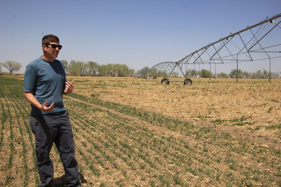
Click the link to read the article on the Water Education Colorado website (Allen Best):
This simple statistic may shock you: Each time a farmer plows his or her field, the soil loses three-quarters of an inch of moisture.
The solutions? They’re more complicated and part of new and expanding soil health programs that seek to help farmers explore how to retain water, improve fertility, and create greater resilience to buffer weather extremes.
Now, with the aid of $25 million in new federal funding, the Colorado Department of Agriculture plans to expand a program called STAR — an acronym for Saving Tomorrow’s Agricultural Resources — from 124 producers, including both farmers and ranchers, to 450. The conduit has been through 16 of the state’s 74 conservation districts, along with three organizations representing corn, sugar beet, and other crop growers. The funding comes through the U.S. Department of Agriculture’s Partnerships for Climate-Smart Commodities Project.
It’s a “game changer,” says Jim Pritchett, an agriculture economist at Colorado State University who grew up on a farm in southeastern Colorado.
“In my career and my childhood in Colorado, I’ve never seen this much direct investment at the producer level,” Pritchett said in September when the grant was announced.
The expanded program, called STAR Plus, will allow Colorado to assist six other Western states in implementing soil health practices and advancing learning. The states are Idaho, Montana, New Mexico, Utah, Wyoming and Washington. CSU, with a $6 million share of that grant, will be the focal point for quantification, verification and other research.
State officials say that fostering techniques to improve soils, making them more sponge-like, can help Colorado improve water quality and use existing water more efficiently. Agriculture continues to account for more than 80% of Colorado’s water use.
For example, healthier soils can absorb moisture from hard rains, while unhealthy soils allow the water to run off. That improved retention also sets the soils up to better withstand dry periods and greater heat. Some techniques in particular, such as less frequent tilling and use of cover crops, can help farmers in the face of rising temperatures.
In 2021, Colorado legislators passed two bills to ramp up efforts to improve soil health. One bill, HB21-1181, authorized creation of a voluntary soil health program housed within the Colorado Department of Agriculture and overseen by an advisory committee composed of representatives from around the state. Another bill, SB21-235, appropriated $2 million in state stimulus funding for the program. With other grants and funding sources, the three-year program had $5 million to work with through 2022.
Colorado Commissioner of Agriculture Kate Greenberg said her department began asking farmers and ranchers in 2019 how adoption of soil health practices might best be accelerated.
The resulting programs are both voluntary and incentive based. They also are highly tailored to individual growers. Instead of top-down regulation, which Greenberg says would “quelch imagination” and necessary innovation, the Star Plus program seeks collaboration, recognizing that farmers bring much expertise to the table and that great uncertainties remain about how best to achieve soil health objectives.
Improvements in soil health won’t occur immediately. The programs have three-year terms for participants during which they will get technical help, including soil testing. CSU researchers meanwhile have been testifying the efficacy of various techniques.
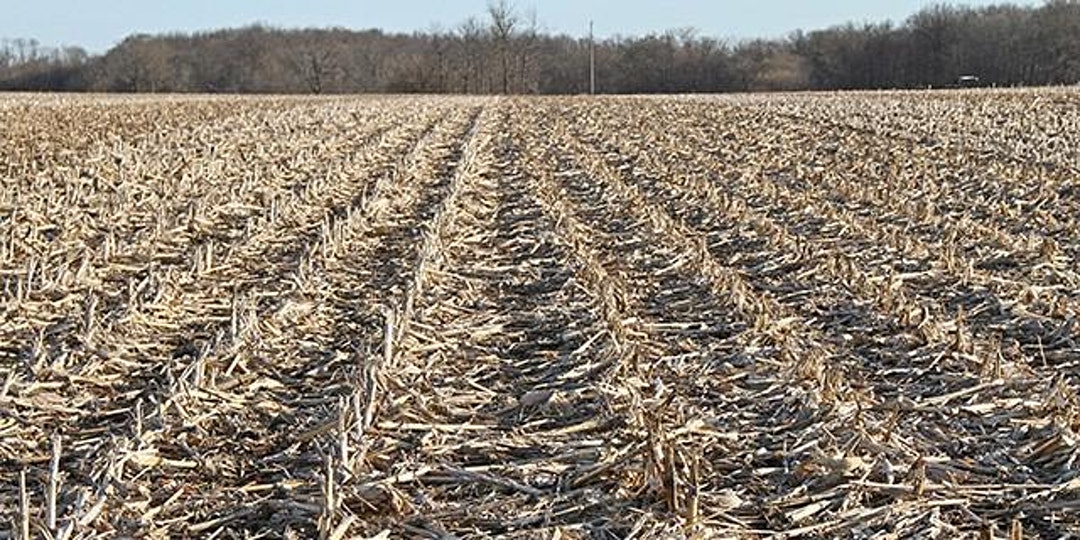
Experts say that five principal tools enhance soil health including keeping the soil covered; keeping living roots in the soil; diversifying crops; minimizing disturbances—for example using no till or minimal till field preparation—and incorporating livestock grazing into land management.
Soil health can be defined as the continued capacity of soil to function as a vital living ecosystem that sustains plants, animals and people.
“The key thing in that definition is that soil is alive,” said Shawn Bruckman, an educator and former professional composter who is on the Eagle County Conservation District Board of Directors. She is also on Colorado’s soil health advisory committee.
“When we are looking at soil health, we are not looking at certain properties of the soil independently,” said Bruckman. “We are looking how it all works together as a whole.”
Bruckman emphasized that soil health varies greatly depending upon climate, soil types and other factors. It can vary greatly even within close proximity, from one field to another.
Given that variability, the Star and Star Plus programs were designed with flexibility as a high value. “You can’t cut and dry the approaches and put them in boxes,” said Bruckman. “They vary so much.”
Some producers may feel comfortable only adopting one or perhaps two of the approaches.
Derek White Heckman values the voluntary nature of the program. He has implemented cover crop, rotation and other soil health practices on 200 acres in the Arkansas River Valley near McClave, Colorado. Next spring he expects to add another 120 acres of the 1,000 acres that he and his father farm.
“I do believe that soil health is very beneficial,” he says. “It has helped our farm out. But I don’t want to ever see things being forced on guys. It really turns them off.”
Allen Best grew up in eastern Colorado, where both sets of grandparents were farmers. Best writes about the energy transition in Colorado and beyond at BigPivots.com.
Click the link to read the article on the Science Magazine website (KEVIN G. WHEELER , BRAD UDALL, JIAN WANG, ERIC KUHN, […], AND JOHN C. SCHMIDT). Here’s an excerpt:
Municipalities of Los Angeles, San Diego, Phoenix, Tucson, Las Vegas, Denver, Salt Lake City, Albuquerque, and Tijuana rely heavily on the river for their water supplies. About 70% of the water is used to irrigate nearly 5.7 million acres (2.3 million hectares) of agriculture. The basin is home to 30 recognized Native American Tribes that hold senior legal rights to divert substantially more water than they currently use. Between 2000 and 2021, the average annual energy generation from the two major dams was 7.6 terawatt-hours (TWh)/year, enough to serve 2.5 million people. The river’s landscapes and ecosystems provide critical habitat for federally protected species and support an extensive recreation-based economy. Today, the entire flow is diverted along its 1400-mile course. In its lower reaches, only 10% of the natural flow reaches Mexico; rarely does the river flow to the Gulf of California…
Current reservoir storage levels could, however, be stabilized if consumptive uses decrease under different scenarios (see fig. S1). If the Upper Basin commits to limit water uses to 4.5 MAF/year (60% of their 7.5 MAF/year allocation, approximately 0.8 MAF/year higher than recent use), then the Lower Basin and Mexico must commit to more than doubling their current maximum reductions in existing use to 3.0 MAF/year (see the figure and fig. S1). In this scenario, the Lower Basin and Mexico receive 66.7% of their allocation, nearly matching the Upper Basin percentage. If the Upper Basin limits their depletions to 4.0 MAF/year (53.3% of their allocation, 0.3 MAF/year higher than recent use), then the Lower Basin and Mexico would need to decrease uses by approximately 2.0 MAF/year to stabilize the reservoirs (see the figure and fig. S1), assuring 77.8% of their allocation. This is close to recently proposed maximum Lower Basin and Mexico commitments to reduce existing use, which would not be invoked until Lake Mead declines further by 3 MAF. Delaying these reductions until then would result in greater loss of storage and stabilization occurring at lower levels than shown in the figure…
Our results show that although current policies are inadequate to stabilize the Colorado River if the Millennium Drought continues, various consumptive use strategies can stabilize the system. However, these measures must be applied swiftly. Although these concessions by both basins may seem unthinkable at present, they will be necessary if recent conditions persist.