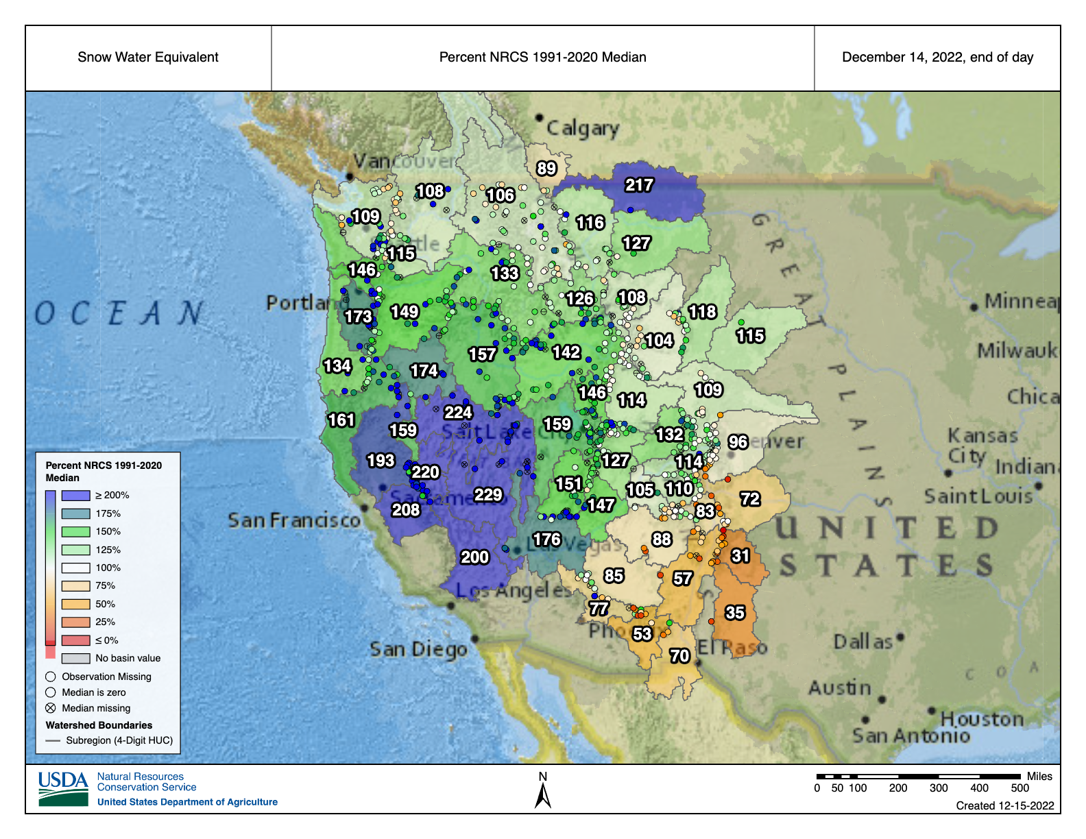
NRCS #Snowpack basin-filled map December 14, 2022 #CRWUA2022


From email from the CWCB (Chris Arend):
The Upper Colorado River Commission (UCRC) announcedsignificant progress in implementing its Five-Point Plan at its meeting on December 14, 2022, at the Colorado River Water Users Association Meeting in Las Vegas, Nevada.
Colorado Commissioner Becky Mitchell emphasized that the most impactful thing that can be done to manage the Colorado River System is to reduce uses in dry years. Colorado achieves this through strict administration of water rights based on hydrology—in 2021, administration impacted water use on over 203,000 acres within the Colorado River Basin in Colorado. Collectively, preliminary data from the UCRC shows that the Upper Division States used 25% less water in 2021 than in 2020 due to constraints on the physical and legal availability of water. “We must continue to live within the means of what the river provides year to year and we ask others to do the same. This is the only way the system will continue as we know it into the future,” said Commissioner Mitchell.
At its meeting, the UCRC released a pre-solicitation for request for proposals for participation in the System Conservation Pilot Program, a large-scale program involving temporary, voluntary, and compensated reductions in consumptive use across the Upper Division States. Conserved system water could help mitigate the impacts of drought in the Upper Basin.
The UCRC also announced progress on the interstate Demand Management feasibility investigation and released a summary report of the study detailing key findings of the interstate investigation. This report will help inform next steps in Colorado’s Demand Management investigation, which will continue into 2023. More information on Demand Management is available at the CWCB website.
The Upper Division States will also consider additional releases from upstream reservoirs pursuant to the Drought Response Operations Agreement, in addition to the 661,000 acre-feet previously committed. The Commissioners emphasized the need to maintain the benefits of this water in Lake Powell.
Click the link to read the article on the Water Education Colorado website (Jerd Smith):
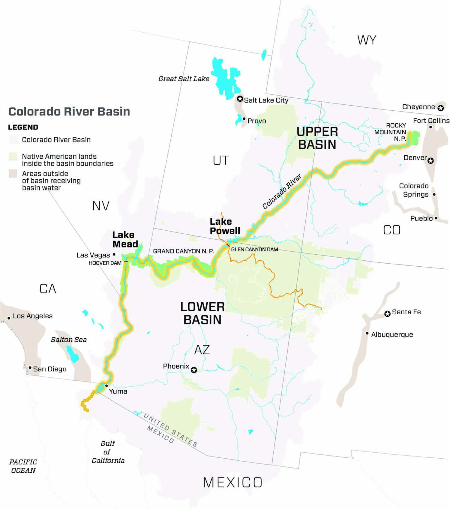
As the Colorado River crisis deepens, a new federal analysis of flows into Lake Powell shows that they will continue to plummet through 2025, before beginning to recover.

James Prairie, a hydrologic engineer for the U.S. Bureau of Reclamation, said flows are likely to be just 24% of average this year, making it unlikely under various planning scenarios that Powell will have enough water for the Upper Basin states of Colorado, New Mexico, Utah and Wyoming to meet their legal commitment to deliver a minimum of 7 million acre-feet of water to the Lower Basin. That amount is already reduced from the historical delivery obligation due to low flows on the river.
The news comes as more than 1,300 of the river’s most powerful water users gather this week in Las Vegas for the Colorado River Water Users Association Conference, the largest annual confab on the river.
This year it has sold out for the first time in its history, according to Crystal Thompson, communications manager at the Central Arizona Project, a major user of Colorado River water and a conference organizer.
In the water world, stream and reservoir measurements are based on what’s known as the water year, which begins Oct. 1. Prairie said Upper Basin flows in water year 2023 are expected to be just 24% of average. In 2024 they are likely to improve, reaching 58% of average, before rising to 61% of average in 2025.
But because Lake Powell is so low — it’s just 23% full with roughly 5.5 million acre-feet of water stored right now — it won’t be able to recover enough water to keep those releases going, Prairie said. And that means that users across the seven-state Colorado River Basin will see more dramatic cutbacks in their water supplies to try to protect remaining supplies in both Lake Powell and Lake Mead, farther downstream.
The basin, mired in a drought believed to be the worst in 1,200 years, is divided into two regions. The Upper Basin includes Colorado, New Mexico, Utah and Wyoming, while the Lower Basin covers Arizona, California and Nevada.
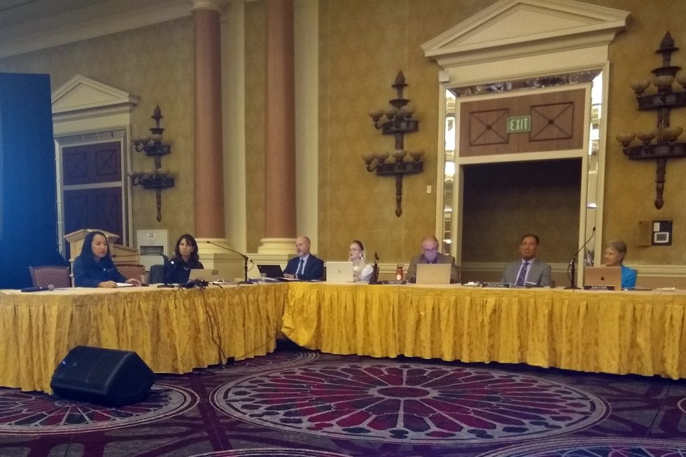
During a meeting of the Upper Colorado River Commission held Wednesday during the confab, hundreds packed a conference room to hear the reports. The commission works to ensure the Upper Basin states receive their allocation of Colorado River Water and that they meet their obligations to send water to the Lower Basin.
“We all know that we are gathering here today in a time of unprecedented crisis in the basin,” said Anne Castle, a Colorado water attorney who President Biden appointed to serve as federal chair of the commission in September 2022.
“We all know we have a huge imbalance between supply and demand and we also know we don’t have much time to correct it,” Castle said.
Last summer U.S. Bureau of Reclamation Commissioner Camille Touton ordered the states to figure out how to reduce water use by 2 million to 4 million acre-feet, but no agreements have been reached, leaving the possibility that the federal government will decide how to make the cuts.
Touton urged water users to continue working together to find a solution to the crisis.
As lakes Powell and Mead have dwindled, all seven states have had to get by with less water and federal forecasts indicate that is likely to be the case for several more years.
In Colorado, major cutbacks have already occurred.
Becky Mitchell, director of the Colorado Water Conservation Board who also represents Colorado on the Upper Colorado River Commission, said the state has already had to temporarily dry up thousands of acres of irrigated farmland because of the crisis.
Mitchell said the state used 25% less Colorado River water in 2021 than it did in 2020 because of the drought.
Critical negotiations among the states are underway to reach a consensus on how to slash water use enough to keep Lake Powell full enough to continue producing power.
“The gap is big enough that no one basin, no one state, no one sector of the economy can solve it alone,” Castle said.
“The real enemy here is not another basin, or another state or alfalfa or golf courses. It is climate-change-induced lower flows. It’s not an enemy that we can defeat. It is one that we have to learn to live with,” she said.
Jerd Smith is editor of Fresh Water News. She can be reached at 720-398-6474, via email at jerd@wateredco.org or @jerd_smith.

Click the link to read the article on The Los Angeles Times website (Hayley Smith and Ian James). Here’s an excerpt:
As California faces the prospect of a fourth consecutive dry year, officials with the Metropolitan Water District of Southern California have declared a regional drought emergency and called on water agencies to immediately reduce their use of all imported supplies. The decision from the MWD’s board came about eight months after officials declared a similar emergency for 7 million people who are dependent on supplies from the State Water Project, a vast network of reservoirs, canals and dams that convey water from Northern California. Residents reliant on California’s other major supply — the Colorado River — had not been included in that emergency declaration.
“Conditions on the Colorado River are growing increasingly dire,” MWD Chairwoman Gloria Gray said in a statement. “We simply cannot continue turning to that source to make up the difference in our limited state supplies. In addition, three years of California drought are drawing down our local storage.”
Officials said the call for conservation in Colorado River-dependent areas could become mandatory if drought conditions persist in the coming months, which some experts say is likely. By April, the MWD will consider allocating supplies to all of its 26 member agencies, requiring them to either cut their use of imported water or face steep additional fees…MWD member agencies, which include the Los Angeles Department of Water and Power, the Municipal Water District of Orange County and the Inland Empire Utilities Agency, will implement voluntary and mandatory conservation measures at the local level based on their particular circumstances, officials said. Those with local supplies or other alternative options may be able to rely on them in the interim.

Click the link to read the article on the Fort Collins Coloradoan website (Sady Swanson). Here’s an excerpt:
The planned $2 billion Northern Integrated Supply Project received a federal Clean Water Act Section 404 Record of Decision from the U.S. Army Corps of Engineers on Friday, Northern Water Conservancy District — the group leading the project — announced in a news release, calling this “a major milestone” for the project.This is the final large-scale permit needed for the project to move forward, Northern Water spokesperson Jeff Stahla told the Coloradoan.
“This action is the culmination of nearly 20 years of study, project design and refinement to develop water resources well into the 21st century,” Northern Water General Manager Brad Wind said in the news release. “This Project will also allow participating communities to serve their customers without targeting water now used on the region’s farms.”
NISP will divert water from the Poudre and South Platte rivers to store in two new reservoirs — Glade Reservoir north of Fort Collins and the smaller Galeton Reservoir east of Ault — to supply water for 15 growing North Front Range communities and water suppliers, including the Fort Collins-Loveland Water District and others in Weld and Boulder counties.,.Northern Water is still in the design phase for NISP, and Stahla said construction could begin in late 2024 or early 2025 and should be operational four years after that, based on the timeline for the Chimney Hollow Reservoir.
Click the link to read the article on The Denver Post website (John Aguilar). Here’s an excerpt:
Arapahoe County may triple the amount of water developers will be made to bring to any new subdivision they build, as a historic drought continues to grip the region and demographers project the county’s population to surge to more than 800,000 by 2050. The stricter limit, which would increase the required groundwater allocation for new development from the state minimum of 100 years to 300 years — known among water managers as the “300-year rule” — will be considered as part of an 18-month, $500,000 water study Arapahoe County is launching this month. Any new regulations or directives from the county’s study, the first of its kind in 20 years, would apply only to unincorporated parts of the county…
The county would join several others in Colorado, like Adams, Elbert and El Paso, that have adopted the 300-year rule as demand on metro area aquifers has shot up over the decades. The population in the Greeley/Boulder/Denver metropolitan statistical area, under which the Denver Basin water table lies, has leaped from less than 2 million in 1985 to nearly 3.6 million last year. It could jump to 4.4 million people by mid-century, according to state demography data. And much of that new development is headed to the eastern periphery of metro Denver, just beyond the E-470 beltway. Sixteen of the top 20 best-selling residential developments in the metro area are in Adams, Arapahoe and Douglas counties, which accounted for 76% of all metro area lots under development, according to 2021 data from real estate analytics firm Zonda. But just how much growth is constrained by stricter water supply requirements in Arapahoe County, with a population of 655,000, is not clear. According to state demography numbers, the county’s projected population will increase to just over 800,000 over the next 28 years, which would translate to an additional demand of 21,200 to 53,300 acre-feet of water a year.

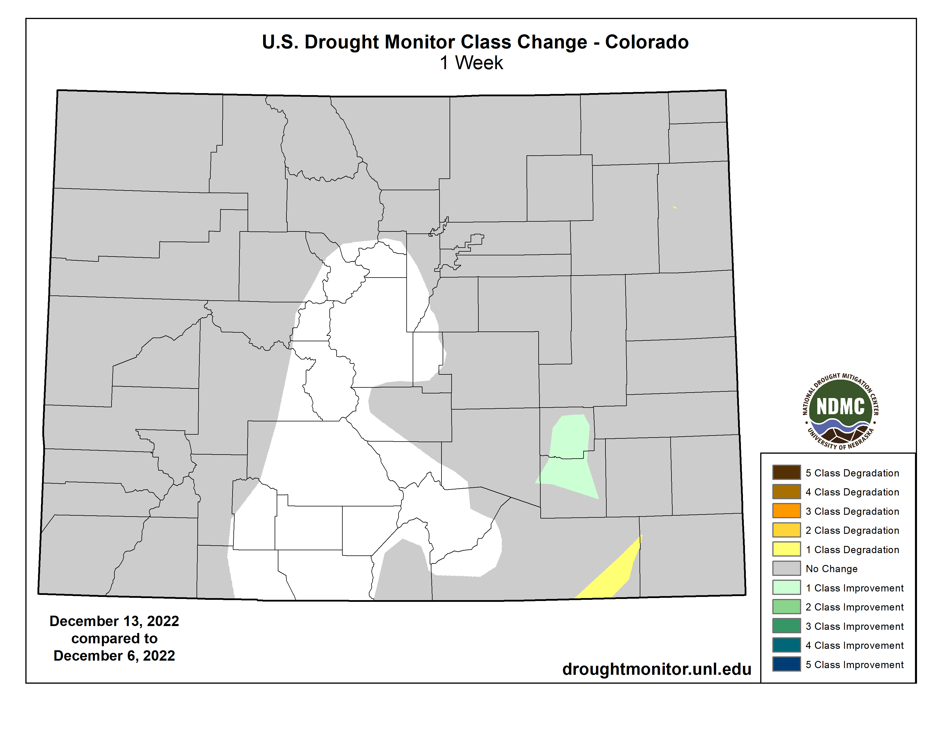
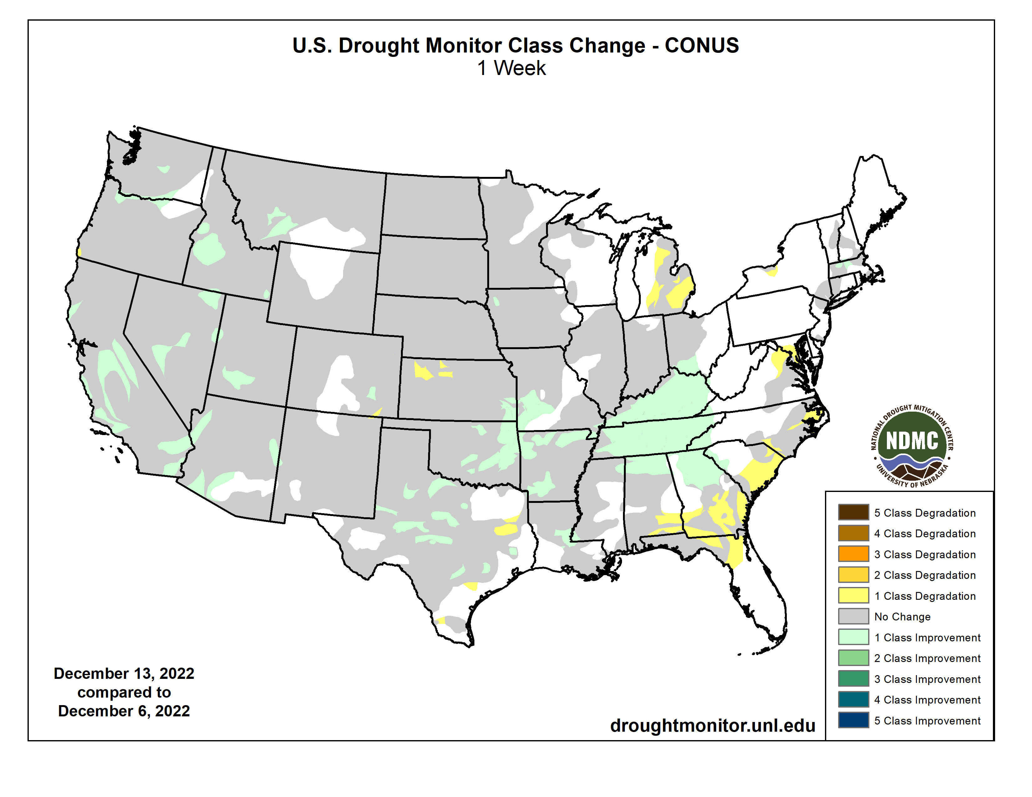
Click on a thumbnail graphic to view a gallery of drought data from the US Drought Monitor website.

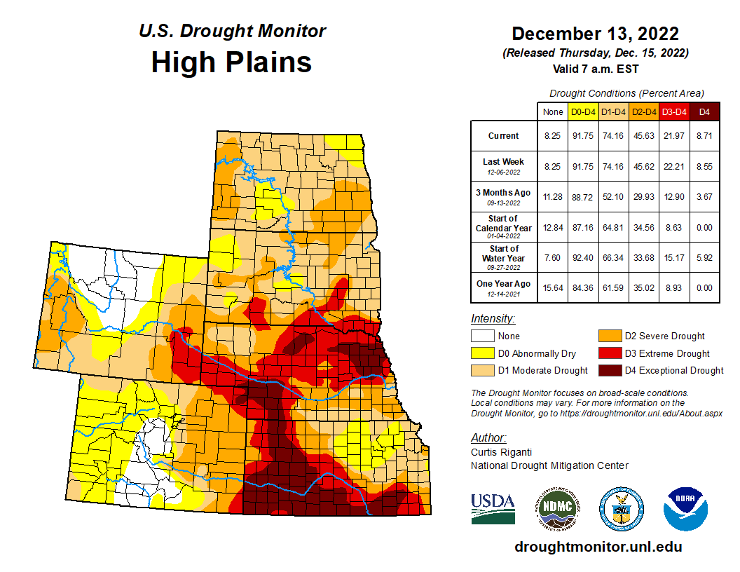

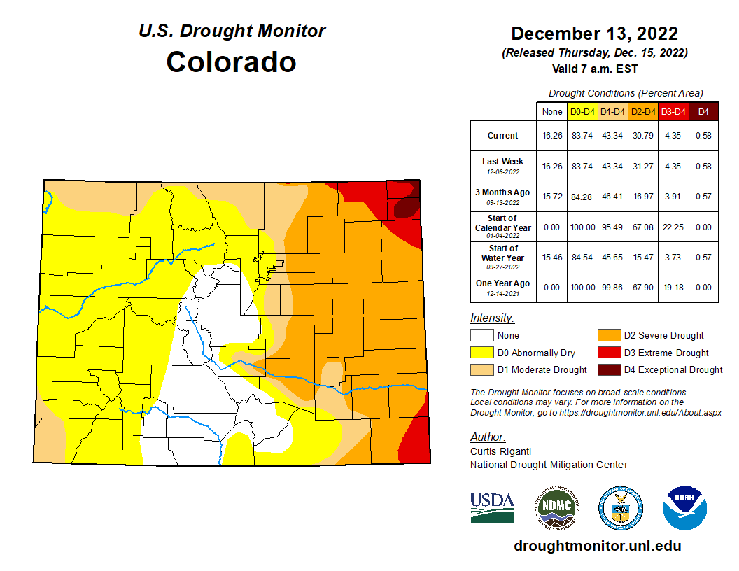
Click the link to go to the US Drought Monitor website. Here’s an excerpt:
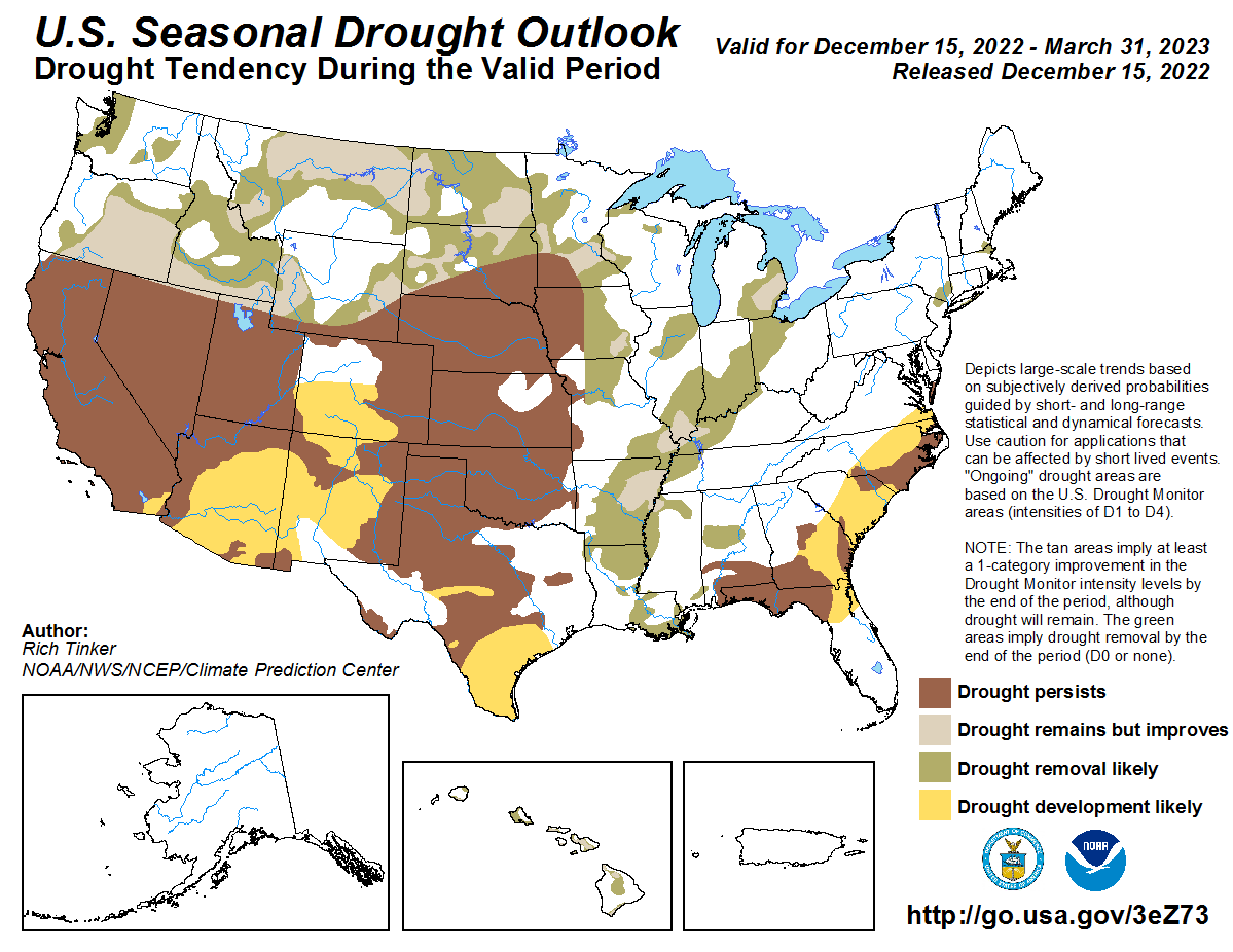
This Week’s Drought Summary
While much of the contiguous U.S. is still experiencing drought or abnormal dryness, several storm systems dropped large amounts of precipitation over the past week in the form of rain or snow, especially in California and from eastern Oklahoma through Tennessee. Since some of this precipitation fell near the Tuesday morning data cutoff, more analysis of the early week precipitation will be performed next week, when more data is available to analyze changes to ongoing drought conditions. In parts of the Great Lakes, Southeast, and northwest Kansas that missed out on recent precipitation, drought or abnormal dryness developed or worsened…
High Plains
Heavier rains accumulated Monday night into early Tuesday in parts of southeast Kansas, leading to some improvements in the drought situation there as precipitation deficits lessened. Dry weather continued in parts of northwest Kansas, where soil moisture deficits and long-term precipitation deficits continued to worsen. A few small changes (one improvement and one degradation) were made in southeast Colorado and adjacent northeast New Mexico, where surface conditions changed in tandem with recent precipitation or lack thereof. Elsewhere, conditions did not change much across the region. Snow and rain that fell Monday night and Tuesday morning from northeast Colorado into Nebraska and southern South Dakota will be analyzed further next week for possible improvements to ongoing drought. Temperature anomalies for the week varied from north to south across the region, with below-normal temperatures occurring in most of North Dakota, while near- or slightly above-normal temperatures were more common in Colorado and Kansas…
West
Widespread improvements to ongoing drought occurred across parts of the West region this week, due to copious amounts of rain or snow. Hefty rainfall amounts in some of the coastal mountain ranges of California caused high streamflow, which lessened precipitation deficits and led to localized improvements. Widespread improvements occurred in parts of the central Sierra Nevada range, where heavy snow fell and added to a healthy early-season snowpack. Recent rain and snow also improved conditions in parts of Arizona, Nevada, Utah, Idaho, southwest Montana, and near the Columbia River along the Arizona/Washington border. Despite recent precipitation, a small part of southwest Oregon saw abnormal dryness develop where precipitation and soil moisture deficits mounted. Temperatures across the West region were generally near or a bit below normal, with the exceptions of New Mexico and eastern Montana, which had above- and below-normal temperatures, respectively…
South
In northern parts of the region, from central and eastern Oklahoma eastward through Tennessee, widespread moderate to heavy rain fell, leading to widespread improvements to ongoing drought and abnormal dryness. In central Oklahoma and north Texas, given that some of this rain fell near the data cutoff, more changes may be made next week as more data becomes available. Wetter recent weather led to improvements in surface conditions and precipitation deficits in central and west-central Texas, leading to some improvements in ongoing drought there. Due to recent heavy rainfall, severe drought areas in southwest Arkansas and near the Louisiana/Mississippi border were removed. A few localized spots in the eastern half of Texas saw conditions worsen after missing out on recent rains. Most of the region saw above-normal temperatures this week, with large portions of central and eastern Texas, Louisiana, and Mississippi seeing readings at least 15 degrees above normal…
Looking Ahead
According to forecasts from the National Weather Service (NWS) Weather Prediction Center, as the weekend progresses into early next week, most areas east of the Rocky Mountains may expect near- or slightly below-normal temperatures. Meanwhile, a much-colder-than-normal airmass should build into the northern Great Plains. Widespread precipitation is forecast for the Great Lakes region through Monday evening, and from the southern Appalachians into the Northeast.
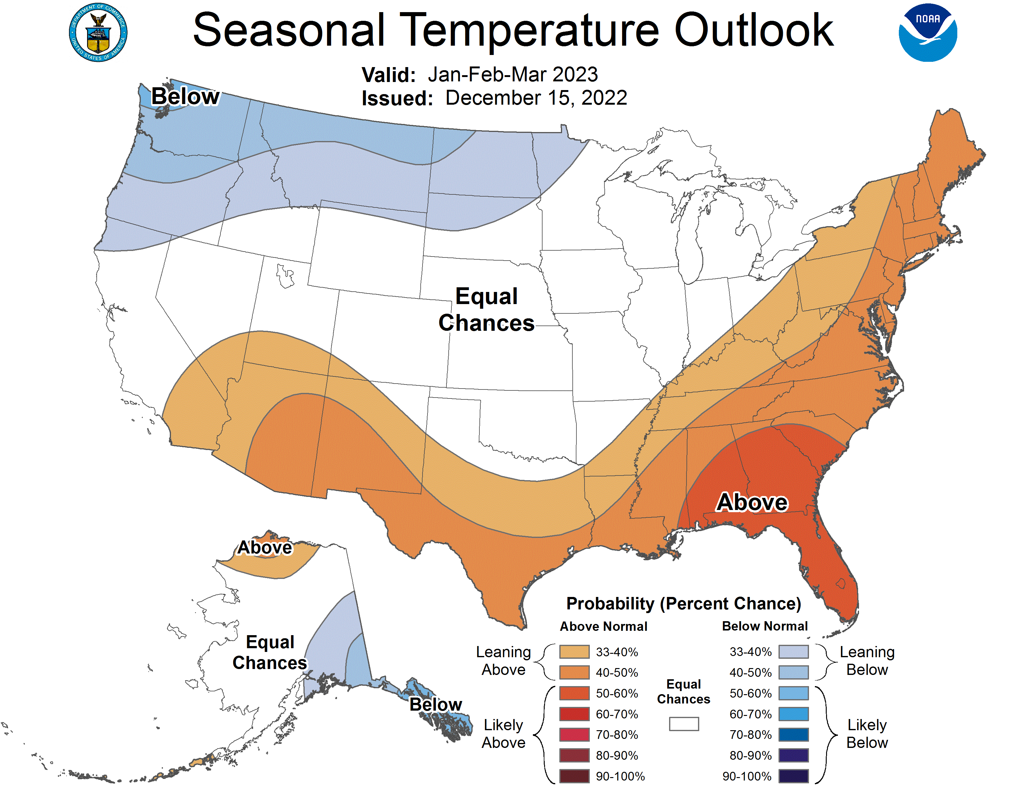
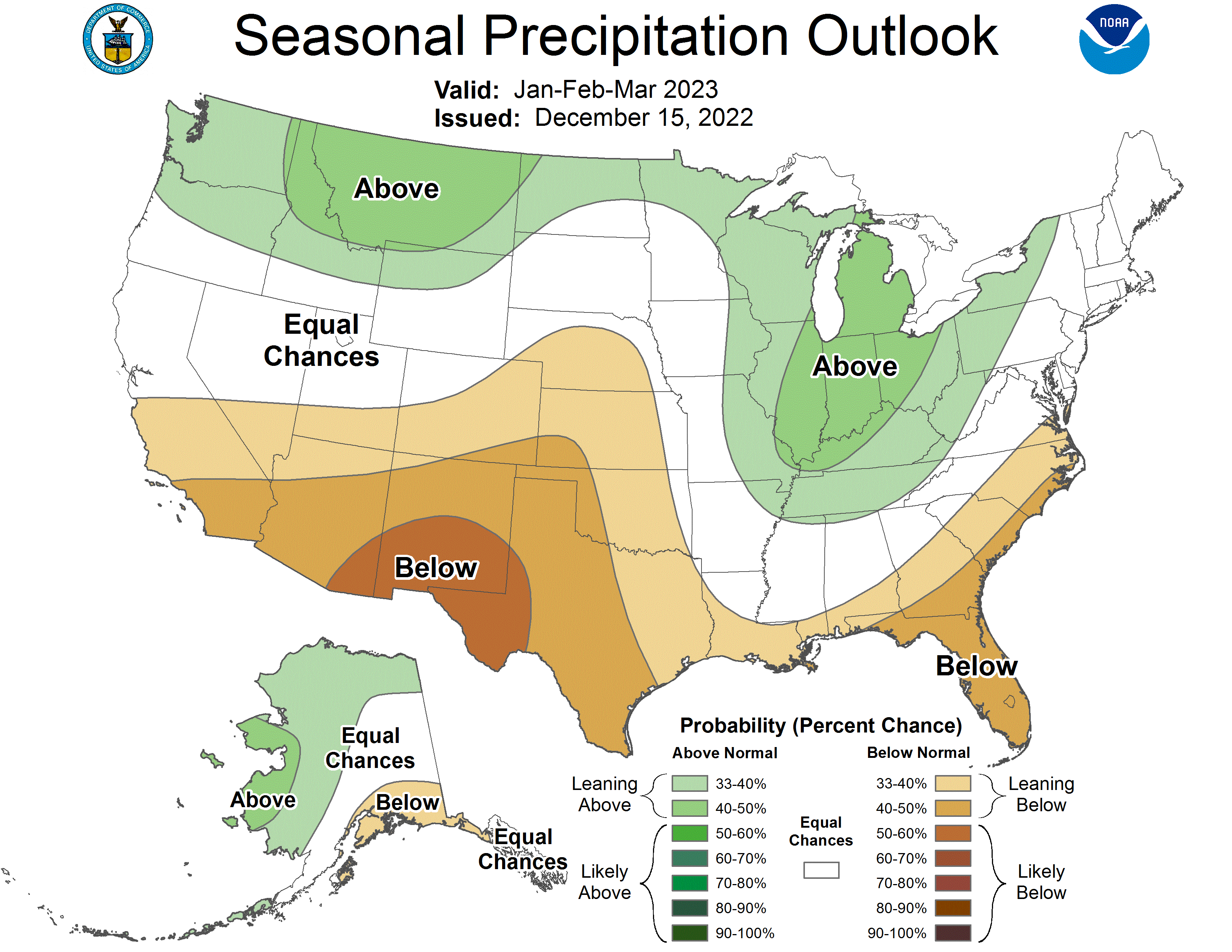
From December 20-28, the NWS Climate Prediction Center outlooks suggest that this cold airmass will spill into parts of the central and eastern U.S., where high confidence forecasts of below-normal temperatures exist. In parts of California and Nevada, forecasts lean toward above-normal temperatures during this period, especially from December 22-28. Precipitation forecasts lean toward above-normal precipitation for the Northern Rockies, Pacific Northwest, Northern Great Plains, and Northeast from December 20-28. Drier-than-normal weather is favored in the Desert Southwest, Southern Great Plains, and the Ohio and Tennessee River valleys. For Alaska, above-normal precipitation is favored in the southern part of the state, while below-normal precipitation is favored in the northern part of the state. The temperature forecasts vary more between the 6-10 and 8-14 day periods, but generally, below-normal temperatures are more likely in eastern Alaska, while the Aleutian Islands are more likely to see warmer-than-normal temperatures.
Matthew L. Druckenmiller, University of Colorado Boulder; Rick Thoman, University of Alaska Fairbanks, and Twila Moon, University of Colorado Boulder
In the Arctic, the freedom to travel, hunt and make day-to-day decisions is profoundly tied to cold and frozen conditions for much of the year. These conditions are rapidly changing as the Arctic warms.
The Arctic is now seeing more rainfall when historically it would be snowing. Sea ice that once protected coastlines from erosion during fall storms is forming later. And thinner river and lake ice is making travel by snowmobile increasingly life-threatening.
Ship traffic in the Arctic is also increasing, bringing new risks to fragile ecosystems, and the Greenland ice sheet is continuing to send freshwater and ice into the ocean, raising global sea level
In the annual Arctic Report Card, released Dec. 13, 2022, we brought together 144 other Arctic scientists from 11 countries to examine the current state of the Arctic system.
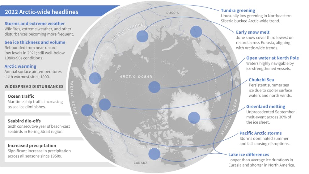
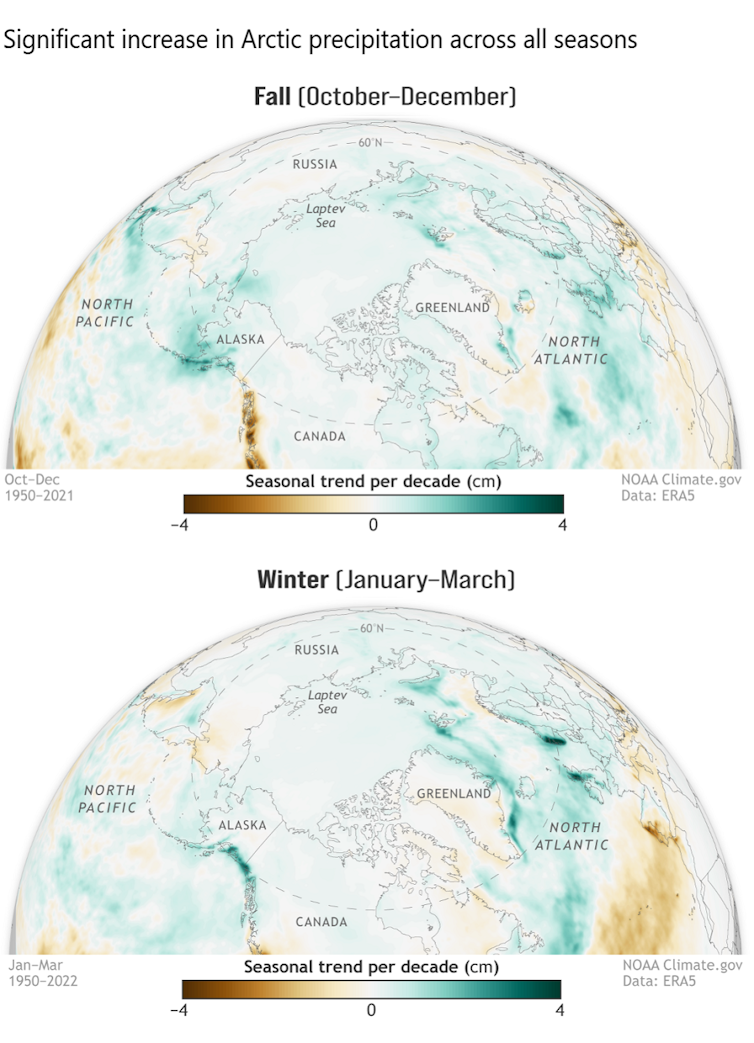
We found that Arctic precipitation is on the rise across all seasons, and these seasons are shifting.
Much of this new precipitation is now falling as rain, sometimes during winter and traditionally frozen times of the year. This disrupts daily life for humans, wildlife and plants.
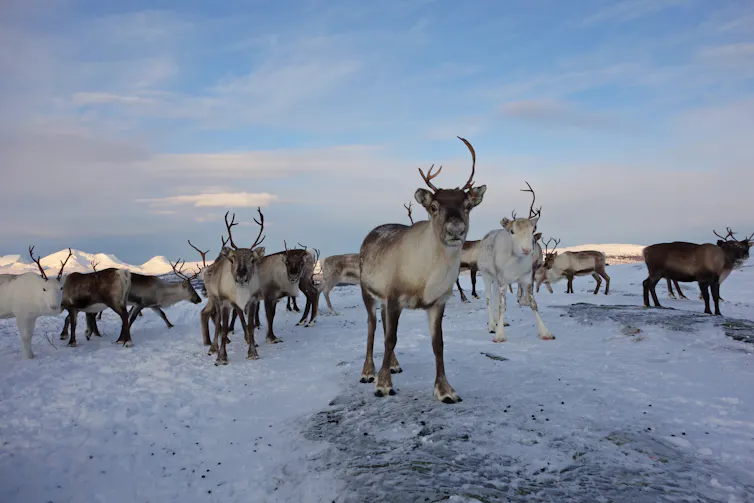
Roads become dangerously icy more often, and communities face greater risk of river flooding events. For Indigenous reindeer herding communities, winter rain can create an impenetrable ice layer that prevents their reindeer from accessing vegetation beneath the snow.
Arctic-wide, this shift toward wetter conditions can disrupt the lives of animals and plants that have evolved for dry and cold conditions, potentially altering Arctic peoples’ local foods.
When Fairbanks, Alaska, got 1.4 inches of freezing rain in December 2021, the moisture created an ice layer that persisted for months, bringing down trees and disrupting travel, infrastructure and the ability of some Arctic animals to forage for food. The resulting ice layer was largely responsible for the deaths of a third of a bison herd in interior Alaska.
There are multiple reasons for this increase in Arctic precipitation.
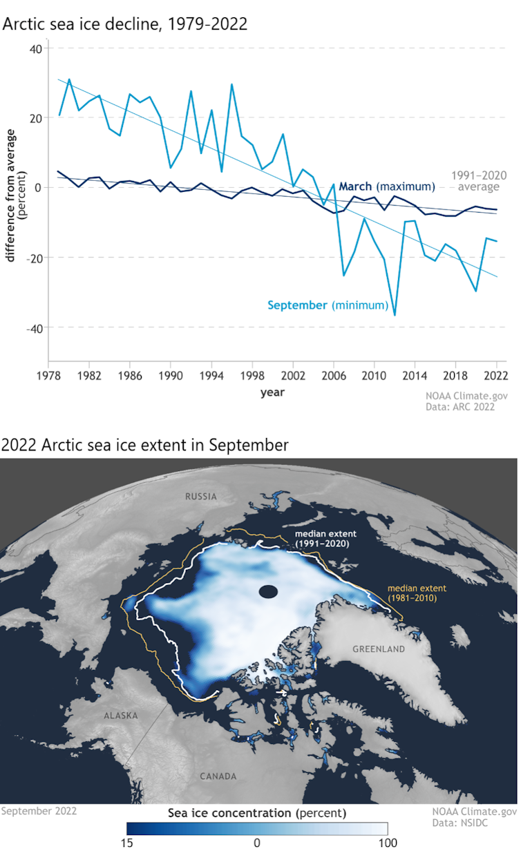
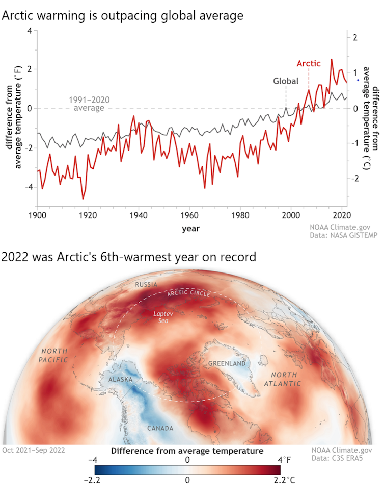
As sea ice rapidly declines, more open water is exposed, which feeds increased moisture into the atmosphere. The entire Arctic region has seen a more than 40% loss in summer sea ice extent over the 44-year satellite record.
The Arctic atmosphere is also warming more than twice as fast as the rest of the globe, and this warmer air can hold more moisture.
Under the ground, the wetter, rainier Arctic is accelerating the thaw of permafrost, upon which most Arctic communities and infrastructure are built. The result is crumbling buildings, sagging and cracked roads, the emergence of sinkholes and the collapse of community coastlines along rivers and ocean.
Wetter weather also disrupts the building of a reliable winter snowpack and safe, reliable river ice, and often challenges Indigenous communities’ efforts to harvest and secure their food.
When Typhoon Merbok hit in September 2022, fueled by unusually warm Pacific water, its hurricane-force winds, 50-foot waves and far-reaching storm surge damaged homes and infrastructure over 1,000 miles of Bering Sea coastline, and disrupted hunting and harvesting at a crucial time.
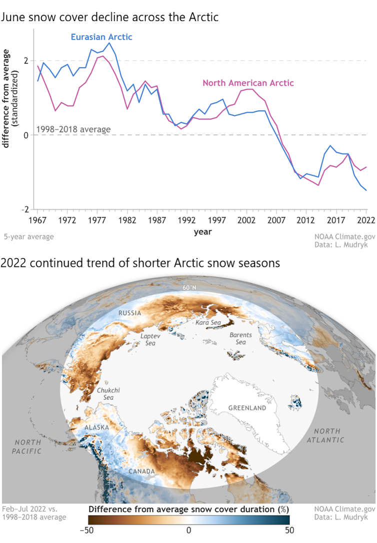
Snow plays critical roles in the Arctic, and the snow season is shrinking.
Snow helps to keep the Arctic cool by reflecting incoming solar radiation back to space, rather than allowing it to be absorbed by the darker snow-free ground. Its presence helps lake ice last longer into spring and helps the land to retain moisture longer into summer, preventing overly dry conditions that are ripe for devastating wildfires.
Snow is also a travel platform for hunters and a habitat for many animals that rely on it for nesting and protection from predators.
A shrinking snow season is disrupting these critical functions. For example, the June snow cover extent across the Arctic is declining at a rate of nearly 20% per decade, marking a dramatic shift in how the snow season is defined and experienced across the North.
Even in the depth of winter, warmer temperatures are breaking through. The far northern Alaska town of Utqiaġvik hit 40 degrees Fahrenheit (4.4 C) – 8 F above freezing – on Dec. 5, 2022, even though the sun does not breach the horizon from mid-November through mid-January.
Fatal falls through thin sea, lake and river ice are on the rise across Alaska, resulting in immediate tragedies as well as adding to the cumulative human cost of climate change that Arctic Indigenous peoples are now experiencing on a generational scale.
The impacts of Arctic warming are not limited to the Arctic. In 2022, the Greenland ice sheet lost ice for the 25th consecutive year. This adds to rising seas, which escalates the danger coastal communities around the world must plan for to mitigate flooding and storm surge.
In early September 2022, the Greenland ice sheet experienced an unprecedented late-season melt event across 36% of the ice sheet surface. This was followed by another, even later melt event that same month, caused by the remnants of Hurricane Fiona moving up along eastern North America.
International teams of scientists are dedicated to assessing the scale to which the Greenland ice sheet’s ice formation and ice loss are out of balance. They are also increasingly learning about the transformative role that warming ocean waters play.

This year’s Arctic Report Card includes findings from the NASA Oceans Melting Greenland (OMG) mission that has confirmed that warming ocean temperatures are increasing ice loss at the edges of the ice sheet.
We are living in a new geological age — the Anthropocene — in which human activity is the dominant influence on our climate and environments.
In the warming Arctic, this requires decision-makers to better anticipate the interplay between a changing climate and human activity. For example, satellite-based ship data since 2009 clearly show that maritime ship traffic has increased within all Arctic high seas and national exclusive economic zones as the region has warmed.
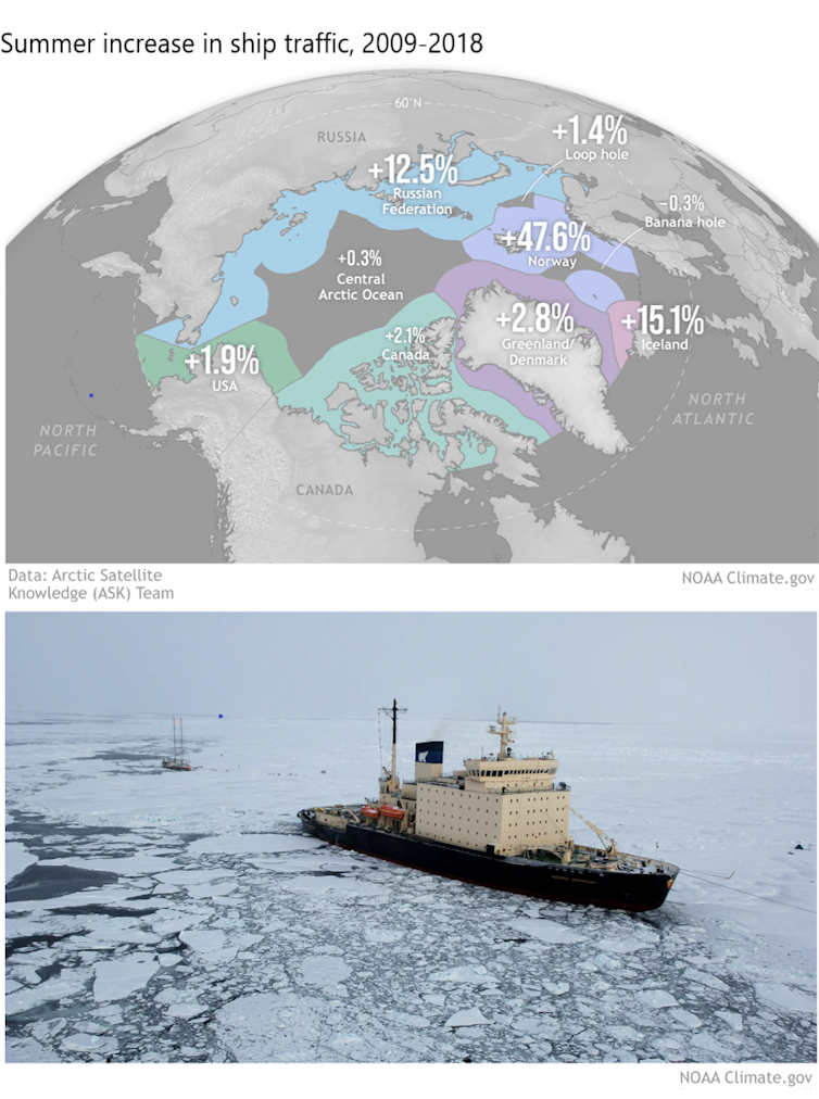
For these ecologically sensitive waters, this added ship traffic raises urgent concerns ranging from the future of Arctic trade routes to the introduction of even more human-caused stresses on Arctic peoples, ecosystems and the climate. These concerns are especially pronounced given uncertainties regarding the current geopolitical tensions between Russia and the other Arctic states over its war in Ukraine.
Rapid Arctic warming requires new forms of partnership and information sharing, including between scientists and Indigenous knowledge-holders. Cooperation and building resilience can help to reduce some risks, but global action to rein in greenhouse gas pollution is essential for the entire planet.
Matthew L. Druckenmiller, Research Scientist, National Snow and Ice Data Center (NSIDC), Cooperative Institute for Research in Environmental Sciences (CIRES), University of Colorado Boulder; Rick Thoman, Alaska Climate Specialist, University of Alaska Fairbanks, and Twila Moon, Deputy Lead Scientist, National Snow and Ice Data Center (NSIDC), Cooperative Institute for Research in Environmental Sciences (CIRES), University of Colorado Boulder
This article is republished from The Conversation under a Creative Commons license. Read the original article.