#Drought news (December 1, 2022): Drought-related conditions improved in areas of #Arizona, #NewMexico, #Nevada, #Washington, #Colorado, #Wyoming, and #Montana

Click on a thumbnail graphic to view a gallery of drought data from the US Drought Monitor website.

Click the link to go to the US Drought Monitor website. Here’s an excerpt:

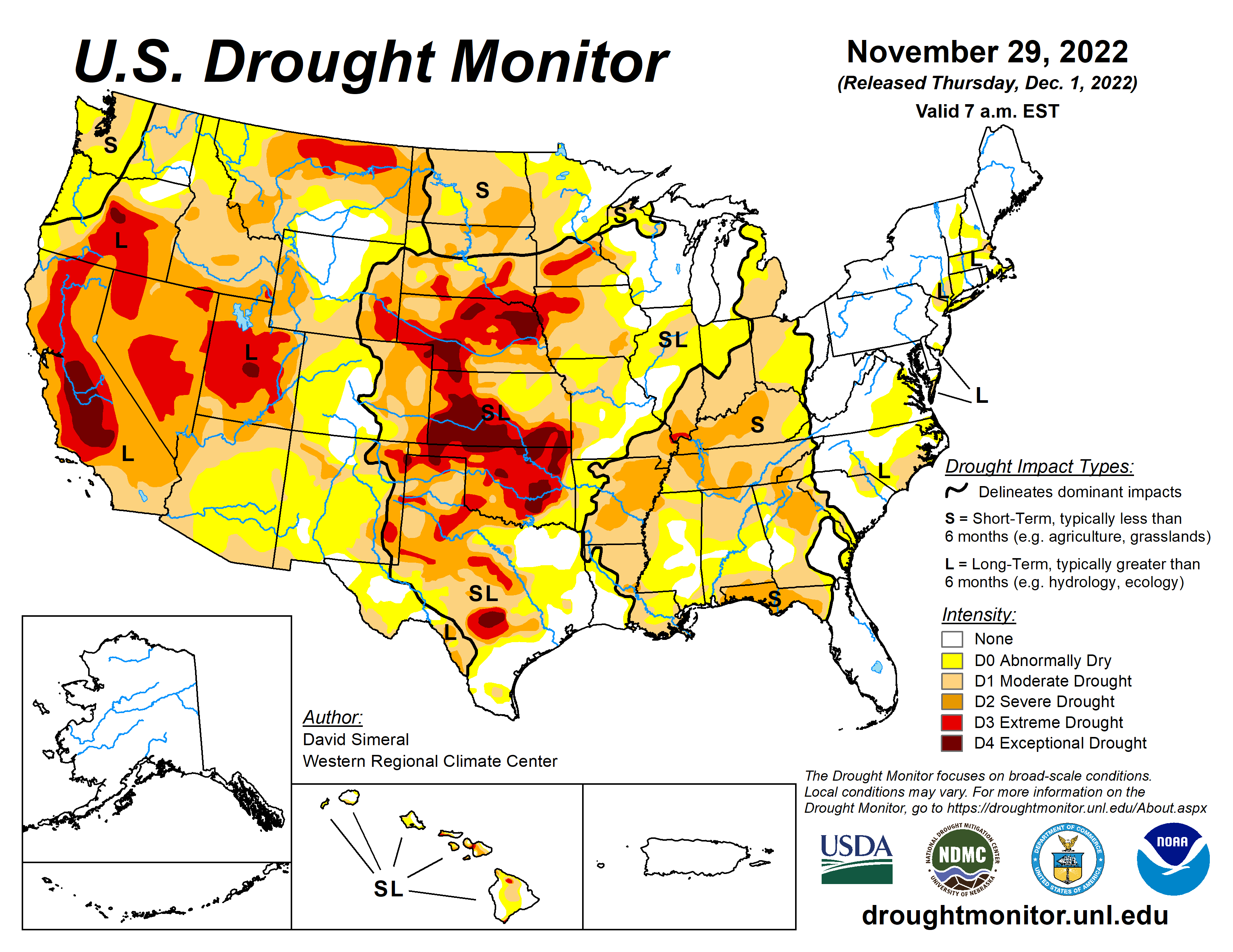
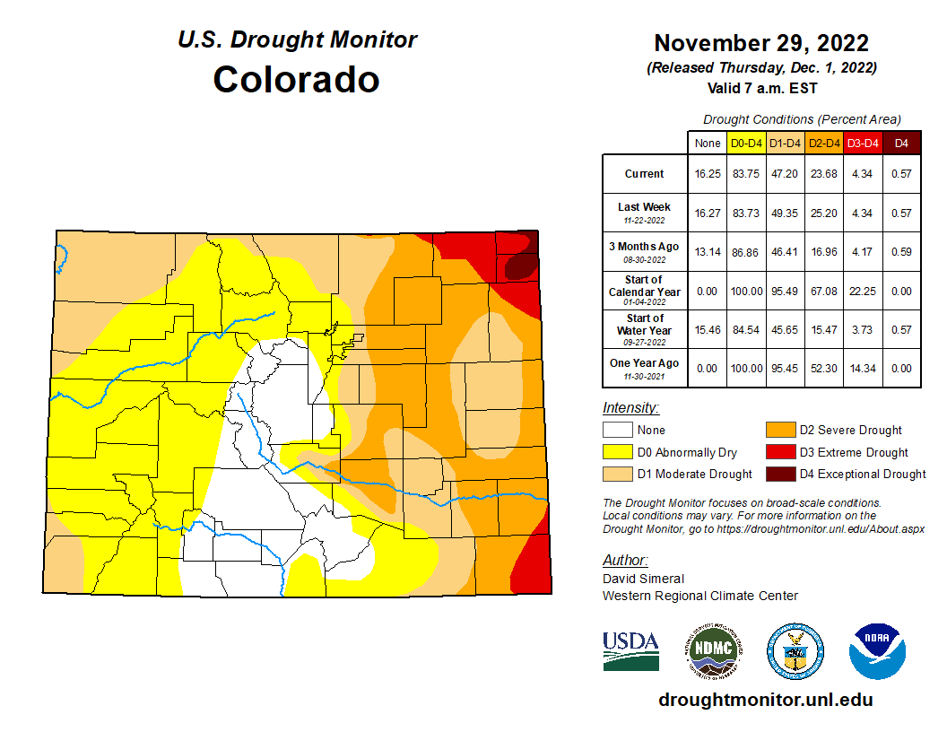
This Week’s Drought Summary

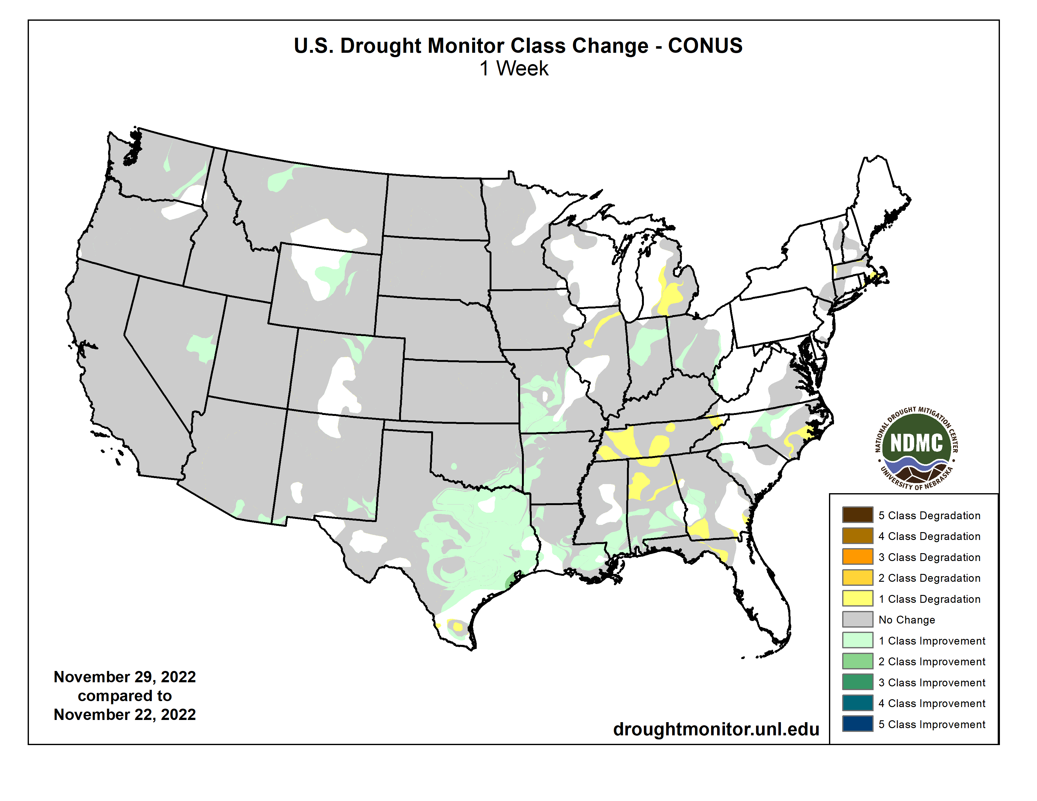
This U.S. Drought Monitor (USDM) week saw areas of moderate to heavy rainfall along the central and western Gulf Coast region as well as areas further inland in the eastern half of Texas, southeastern Oklahoma, and southwestern Arkansas. In these areas, targeted improvements were made in drought-affected areas. Additionally, an outbreak of severe weather, including severe thunderstorms with tornadoes and wind damage, impacted areas of the South (Louisiana, Mississippi, and Alabama) overnight on Tuesday (Nov 29), resulting in severe damage and loss of lives reported. In the Southeast, isolated heavy rainfall accumulations led to improvements on the map in areas of Alabama, Georgia, and North Carolina. Elsewhere in the Southeast, short-term dryness over the past 90 days led to expansion of areas of severe drought in the Florida Panhandle, where rainfall deficits ranged from 3 to 9+ inches. In the Northeast, only minor changes were made on the map in areas of eastern Massachusetts and Rhode Island in response to precipitation shortfalls during the past 30–60-day period as well as below-normal streamflow activity and lack of groundwater recharge in areas of Cape Cod. In the Midwest, areas of moderate drought expanded in southern Michigan and northern Illinois where short-term precipitation deficits are negatively impacting soil moisture and streamflow levels. In the High Plains, generally dry and warmer-than-normal temperatures (2 to 10+ deg F above normal) prevailed across much of the region during the past week. Out West, drought-related conditions improved in areas of Arizona, New Mexico, Nevada, Washington, Colorado, Wyoming, and Montana. In terms of snowpack conditions in the region, the Natural Resources Conservation Service (NRCS) SNOTEL network is currently reporting the following region-level (2-digit HUC) snow water equivalent (SWE) percentages of median for the date (Nov 29): Pacific Northwest 134%, California 135%, Great Basin 157%, Lower Colorado 152%, Upper Colorado 98%, Rio Grande 76%, Arkansas-White-Red 66%, Missouri 101%, and Souris-Red-Rainy 81%. Looking back at the last several months, the contiguous U.S. experienced its 8th warmest September-October period on record since 1895 in terms of average temperatures (+2.2-deg F anomaly) and maximum temperatures (+2.6 deg F), according to NOAA National Centers for Environmental Information (NCEI). Precipitation in the contiguous U.S. during the September-October 2022 period ranked as the 11th driest (-1.14-inch anomaly)…
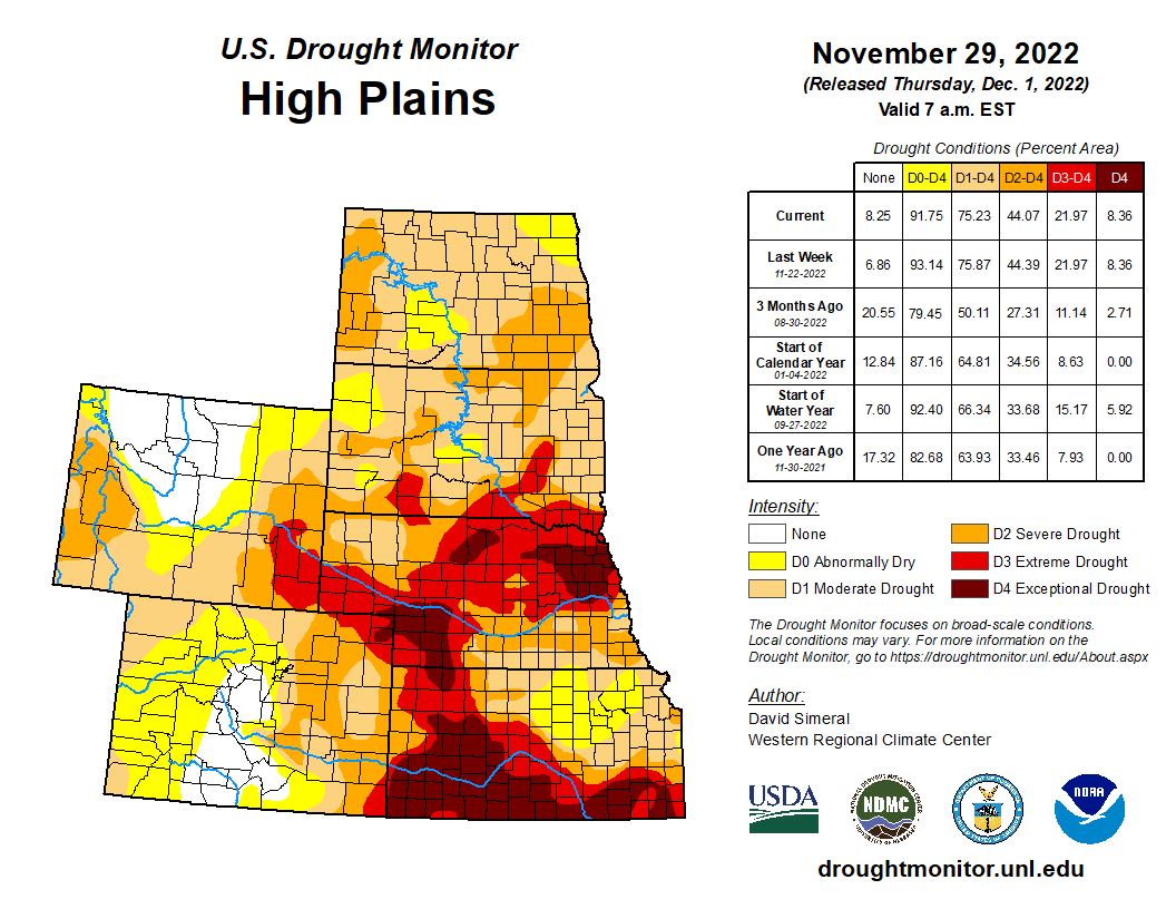
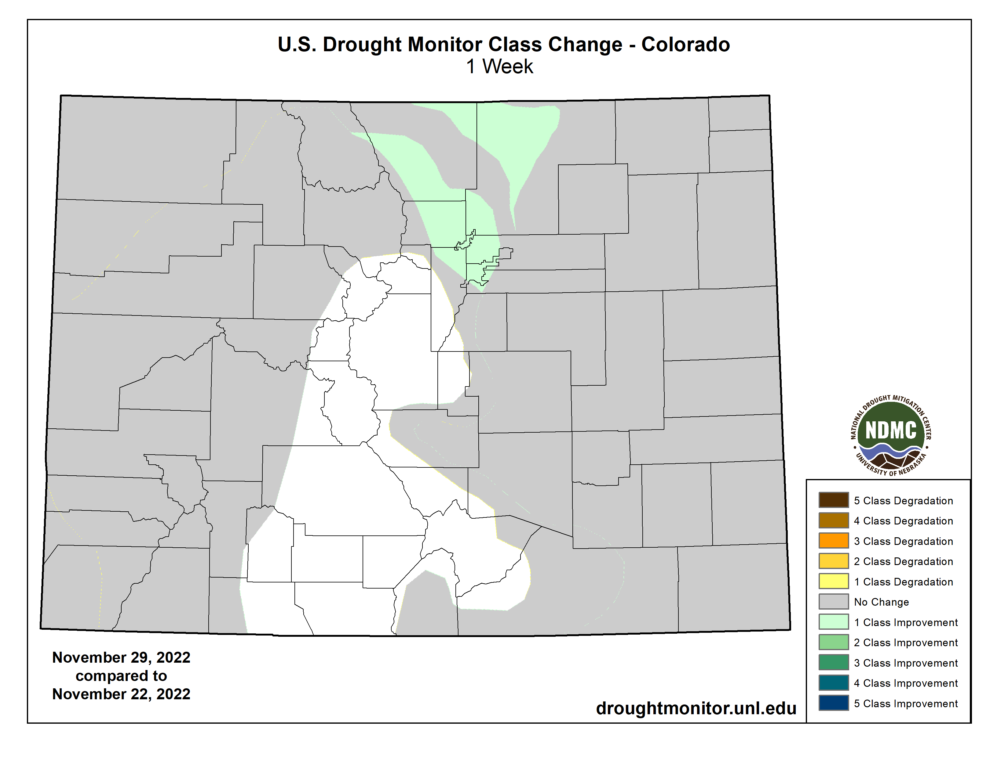
High Plains

On this week’s map, improvements were made on the map in the greater Denver-Boulder area of Colorado and in portions of eastern Wyoming in response to above-normal precipitation in the short-term. Elsewhere in the region, no changes were made on the map. For the week, average temperatures were well above normal across the Northern Plains with average temperatures ranging from 2 to 10+ deg F above normal. However, the warmer temperatures melted the portions of the snow in areas of North Dakota allowing for beneficial percolation of meltwater into the still-unfrozen soils. According to NOAA NCEI, the Great Plains Region saw its 9th warmest (+3.0-deg F anomaly) and 8th driest (-1.4-inch anomaly) September-October on record. Statewide, Wyoming experienced its 3rd warmest (+4.2-deg F anomaly) and Colorado its 8th warmest (+3.1 deg F anomaly) September-October period on record…
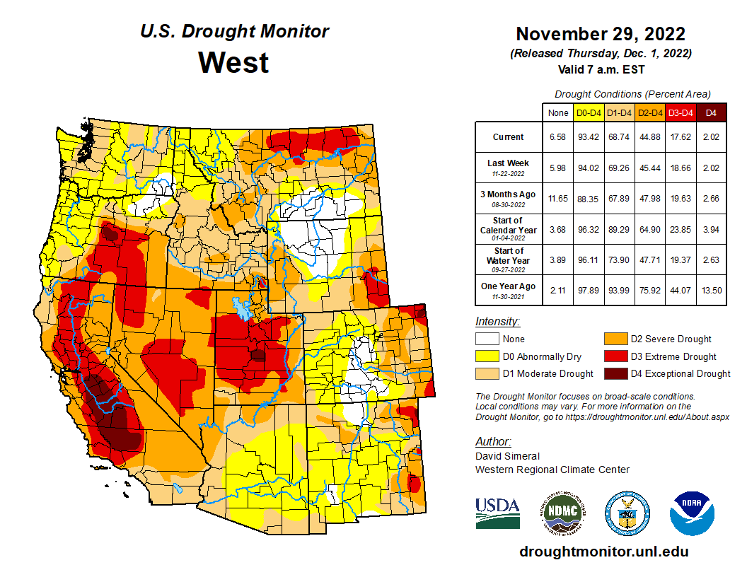
Colorado Drought Monitor one week change map ending November 29, 2022.

West

Out West, some minor changes were made on the map in southeastern Arizona, southern New Mexico, east-central Nevada, and north-central Montana. In east-central Nevada, areas of Extreme Drought (D3) were reduced in White Pine County in response to improving conditions following above-normal precipitation during the monsoon season as well as from above-normal SWE levels currently observed in the Schell Creek and Snake ranges. Likewise, in southeastern Arizona and southwestern New Mexico, above-normal precipitation during the monsoon season as well as over the past several months led to the removal of areas of Severe Drought (D2). Further to the north in Montana, above-normal precipitation since the beginning of the Water Year (Oct 1), led to reduction of areas of Extreme Drought (D3). In terms of snowpack conditions across the region, near-normal to above-normal SWE levels are being reported across the basins of the Sierra Nevada, Great Basin ranges, Cascades, Northern Rockies, Wasatch, and areas of the Central Rockies. Further south, the basins of Southwest Colorado and the Rio Grande are currently below normal. For the week, average temperatures continued to be cooler than normal (2 to 10 deg F below normal) across much of the region except for areas of Northern California, Montana, and eastern portions of Colorado and Wyoming. Overall, much of the region was dry this week, however, some significant snowfall accumulations were observed in Pacific Northwest mountain ranges including the Olympics, Cascades, and Blue Mountains of northeastern Oregon. Likewise, snowfall was observed this week in the Wasatch Range as well as the Northern and Central Rockies, with additional mountain snow forecasted to impact areas of the West this week. According to NOAA NCEI, the September-October 2022 period was the warmest (+4.3-deg F anomaly) on record for the Rockies and Westward Region, 3rd warmest for the West Climate Region (includes California and Nevada) (+4.8-deg F anomaly), and warmest on record for the Northwest Climate Region (+5.5-deg F anomaly)…

South

In the South, improvements were made across areas of the eastern half of Texas, southeastern Oklahoma, western Arkansas, and southern Mississippi where locally heavy rainfall accumulations (3 to 8+ inches) were observed. Despite this week’s rainfall in portions of Texas, streamflows in the Hill Country remain below normal with numerous gauging stations reporting levels in the bottom 10th percentile, according to the USGS. In terms of reservoir storage in Texas, monitored water supply reservoirs statewide are currently 69.9% full, according to Water Data for Texas. Some low reservoir storage levels are currently being observed in the western half of the state, including at Medina Lake (west of San Antonio) which is currently 6.7% full. According to NOAA NCEI, the South Climate Region experienced its 13th driest (-2.34-inch anomaly) September-October period on record, with Louisiana observing its 6th driest (-4.35–inch anomaly) for the contemporaneous period…

Looking Ahead

The NWS WPC 7-Day Quantitative Precipitation Forecast (QPF) calls for moderate-to-heavy precipitation accumulations (including heavy snowfall accumulations) ranging from 2 to 5+ inches (liquid) across much of the Cascades of Oregon and Washington, Klamath Mountains, Coast Ranges of Northern California, and the Sierra Nevada Range. In the Intermountain West, 1 to 3+ inch (liquid) accumulations are expected in central and northern Idaho ranges as well as in the Teton Range of Wyoming. Elsewhere in the conterminous U.S., heavy precipitation accumulations are expected in Kentucky and Tennessee (3 to 5+ inches liquid) as well as in areas of the Northeast including New York, New Hampshire, and Maine. The CPC 6-10-day Outlooks call for a moderate-to-high probability of above-normal temperatures for the South, Southeast, and Mid-Atlantic regions, while much of the West, Plains, and Midwest are expected to be cooler than normal. Precipitation is forecasted to be above normal across the Pacific Northwest, Northern California, and across much of the Eastern Tier. Below-normal precipitation is expected in Florida.

US Drought Monitor one week change map ending November 29, 2022.

#Colorado Republican Result Worse than Debacle in 2018 — The Buzz @FloydCiruli

Click the link to read the post on The Buzz website (Floyd Ciruli):

I asked in a November 2 blog post if Colorado Republicans would best the 45 percent high they won in statewide races in 2018–answer, No. Jared Polis won the governorship in 2018 by 10 points. This year, Polis won by 19 points.

Along with the state sweep, Republicans were beaten in the marquee Federal competitions. Senator Michael Bennet was reelected by 15 points and the new 8th Congressional district rated leaning Republican, was won by the Democrats in a close race with more than 1500 votes. The seemingly safe district of controversial Congressperson Lauren Boebert was held by only 500 votes.

RELATED: Will Colorado Republicans Win More Than 45% of the Vote?

Winter #wheat has been helped by rain on the southern Plains and snow on the northern Plains, but this crop will still need some assistance over the winter and especially next spring — @DroughtDenise

Never write off winter wheat, though. It’s a tough crop. H/t Brad Rippey @usda_oce

EVs now across #Colorado — @BigPivots

Leaf charging in Frisco September 30, 2021.

Click the link to read the article on the Big Pivots website (Allen Best):

Every corner of the state now has EV owners. I am told that one of Colorado’s 64 counties has no registered EVs, but my trolling of the Colorado Energy Office EV Dashboard could fine none.

Not surprisingly, the highest-per-capita rate for EVs were in Boulder County, with almost 36 per 1,000 residents, and Pitkin County – home to Aspen – with 28.75 per thousand. And Douglas County (Castle Rock) comes in third at about 20 per thousand.

After that, it’s a mixture of resort counties like Eagle, Summit, Larimer, and Denver, who all come in at 16 to 17 per thousand.

Cheyenne Wells (top photo), on the state’s eastern tier, too small to have a restaurant with operations aside from a few hours at mid-day, still manages to have 4 EVs on its roads adjacent to Kansas. On the opposite side of the state, Dolores County has 6 on the roads going into Utah.

The dashboard also says that pickup trucks now represent 17% of EV vehicles in Colorado, behind electric SVS at 39% and passenger cars at 19%.

For a deeper dive, go to the Colorado Energy Office EV Dashboard.

The current soil moisture percentile is less than 10% for parts of the Great Plains and Midwest — @DroughtDenise

Soils freeze amid the cold winter temperatures, and dry conditions allow soils to freeze to greater depths. https://cpc.ncep.noaa.gov/products/Drought/Monitoring/smp.shtml

The amount of topsoil moisture rated short to very short is highest in #Nebraska and #SouthDakota at 89% and 88%. The value for the contiguous US is 50%, which is considerably higher than the previous 7 years. This is the last USDA issuance of moisture values for 2022.

Editorial: An unhappy 100th for the #ColoradoRiver Compact — The #ColoradoSprings Gazette #COriver #aridification #CRWUA2022

Glen Canyon Dam, seen here in May 2022, was a major electrical generation but has produced less as volumes in Lake Powell have declined. Photo credit: Allen Best/Big Pivots

Click the link to read the editorial on The Colorado Springs Gazette website. Here’s an excerpt:

As The Gazette’s report reminded us, our state’s defining river today is in greater peril than it has been at any time in history amid the West’s explosive growth and a 23-year drought that has limited the river’s flows year after year…conservation efforts alone seem like half-measures that inevitably lead to diminishing returns. As we asked here recently, what if we started putting more water into the Colorado River Basin instead of ratcheting down ever further how much is taken out of it? Increase supply, in other words, instead of futilely trying to curb demand. Some are taking up that challenge.

Arizona’s state government is laying plans with Mexico for a jointly developed desalination plant that would turn seawater into fresh water along the Arizona-Mexico border, where the Colorado River empties into the Sea of Cortez. That has the potential to lower water use downstream and leave more up river in Upper Basin states. There’s also great potential in new technology enabling water reuse, which is not so much a form of conservation as it is turning old water into new. Israel recycles and reuses nearly 90% of its water and Spain over 30%, a water expert recently wrote in a Gazette commentary.

Let’s Stop Blaming the Compact — Sustainable Waters #ColoradoRiver #COriver #aridification #CRWUA2022

Members of the Colorado River Commission, in Santa Fe in 1922, after signing the Colorado River Compact. From left, W. S. Norviel (Arizona), Delph E. Carpenter (Colorado), Herbert Hoover (Secretary of Commerce and Chairman of Commission), R. E. Caldwell (Utah), Clarence C. Stetson (Executive Secretary of Commission), Stephen B. Davis, Jr. (New Mexico), Frank C. Emerson (Wyoming), W. F. McClure (California), and James G. Scrugham (Nevada) CREDIT: COLORADO STATE UNIVERSITY WATER RESOURCES ARCHIVE via Aspen Journalism

Click the link to read the article on the Sustainable Waters website (Brian Richter):

While floating through the Grand Canyon recently, river guide extraordinaire Bruce Keller taught me a new word: “mumpsimus.”

It means “a traditional notion that is obstinately held although it is unreasonable.”

I immediately thought of the way that the Colorado River Compact is being repeatedly blamed for the current water crisis in the Colorado River system. The oft-stated accusation is that the water shortages we’re experiencing now can be blamed on the fact that the framers of the Compact allocated too much water — much more than the river system could actually deliver. “The river was over-allocated from the beginning.”

In full disclosure, I must admit that I have made similar statements myself in the past. I am guilty of mumsimus. But I have reconsidered my position.

I’ve concluded that blaming the Compact is misleading and unhelpful. Implicating a Compact fashioned 100 years ago obfuscates rightful accountability. The situation we’re in now is not the fault of the Compact’s architects. This one’s on us, on our generation, not theirs.

Here’s my rationale.

We’ve Never Used as Much as Was Allocated

The framers of the Colorado River Compact of 1922 allocated 15 million acre-feet (MAF) per year for use within the US: 7.5 MAF each for the Upper and Lower Basins.** They anticipated that more water would eventually need to be allocated to Mexico. A 1944 treaty with Mexico set that country’s allocation at 1.5 MAF/year.

In sum, a total of 16.5 MAF/year has been allocated for human use.

Annual human uses of the river’s water have never come close to 16.5 MAF. According to estimates by the US Bureau of Reclamation, the average annual consumption for human uses since 2000 is about 12.6 MAF — far below what the Compact allows. The annual use would have likely been higher than 12.6 MAF if not for the Compact. In the early 2000s, California was beginning to use more than its 4.4 MAF portion of the 7.5 MAF/year allocated among the Lower Basin states of California, Arizona, and Nevada, but the federal government reeled it back in so that the total Lower Basin use would not exceed 7.5 MAF.

Yes, There Were Big Oversights 

If the Compact is to be faulted, it should be for the things it didn’t say or anticipate. The framers of the Compact didn’t account for three critically important uses and needs for the river’s water today: (1) water rights legally held but not yet used by Native American tribes; (2) water needed to sustain natural ecosystem health; and (3) evaporation from the many reservoirs that would eventually be built.

Evaporative losses from the reservoirs, plus what is evaporated and transpired from the river and its associated riparian and wetland ecosystems, accounts for another 2.4 MAF/year, bringing the total volume of water consumed for human and natural purposes to about 15 MAF/year.

Still well below what was explicitly allocated in the Compact and the international treaty with Mexico.

I’ll return to the issue of Native American rights and ecosystem needs in a moment.

The Compact Held Up for Nearly 80 Years

Perhaps the greatest tribute to the durability of the Compact is the fact that cities and farmers were able to prosper for nearly 80 years after the Compact was put into place. Cities dependent on the river grew exponentially, and basin farmers were able to grow food for our country and other nations.

The reservoirs in the Colorado River Basin were nearly full in 2000. Virtually nobody was concerned about water shortages. In fact, the conversation at that time was centered on how to share surplus water!

Updated Colorado River 4-Panel plot thru Water Year 2022 showing reservoirs, flows, temperatures and precipitation. All trends are in the wrong direction. Since original 2017 plot, conditions have deteriorated significantly. Brad Udall via Twitter: https://twitter.com/bradudall/status/1593316262041436160

And Then the Climate Changed

During the 20th century, an average of 16.4 MAF/year of water flowed into and through the Colorado River each year, enough to fully serve all human uses and losses of water to evaporation.

Since 2000, that flow of water has decreased to 13.5 MAF/year, the combined result of a warming climate and lessened precipitation — now recognized as the driest 23 years in the past 1200 years. That has left a shortfall of 1.5 MAF/year, and we’ve been pillaging the water stored in big reservoirs such as Lake Mead and Lake Powell to make up the deficit.

The true reason we are experiencing a water shortage crisis in the Colorado River Basin is not because of flaws in the Compact. It is because we have been unable to reduce our use of water commensurate with the reality that the river no longer produces what it did in the last century. If we can’t own up to this truth we will not be able to build a water-secure future.

Making Things Right

It is high time to reckon with the river’s limits, and with the inherent rights of the indigenous inhabitants of the river basin. This is the time — at the 100th anniversary of the Colorado River Compact — to make things right.

The allocations of water made in the Compact and subsequent agreements are now clearly unattainable and should be revised. Given that reality, let’s take the opportunity to also address some shortcomings in the way the Compact was structured. Any reallocation of the river’s water should begin with an inalienable reserve of water for Native Americans — including both what they are already able to use, plus the other water to which they are legally entitled but not using presently. What is not presently being used by the tribes should be left in the river for use by its oldest inhabitants: ancient native creatures like the Colorado pikeminnow and the humpback chub that have been swimming in the river system for millions of years but now teeter at the brink of extinction.

Once the indigenous reserve is legitimately accounted for, the remainder of the 13.5 MAF/year flowing downriver should be shared equitably — in portions that will likely need to be renegotiated among the states and Mexico.

Only by adjusting human needs to what the river is able to give, and only by aligning those needs in a just, equitable, and sustainable manner with native peoples and ecosystems, will we be able to again realize the prosperity envisioned by the Compact’s architects.

Dories at rest on a glorious Grand Canyon eve. Photo by Brian Richter

** The Compact also allowed the lower basin states to use their own tributaries to the Colorado, but that additional 1 MAF doesn’t get included in the river’s annual budget tracking so I’ll ignore it here as well simply to match numbers with the Bureau of Reclamation. However, true and full water budget accounting for the river basin should include the water supply from the tributaries in the Lower Basin as well as the uses of that water.