Click the link to read the article on The Denver Post website (Conrad Swanson). Here’s an excerpt:
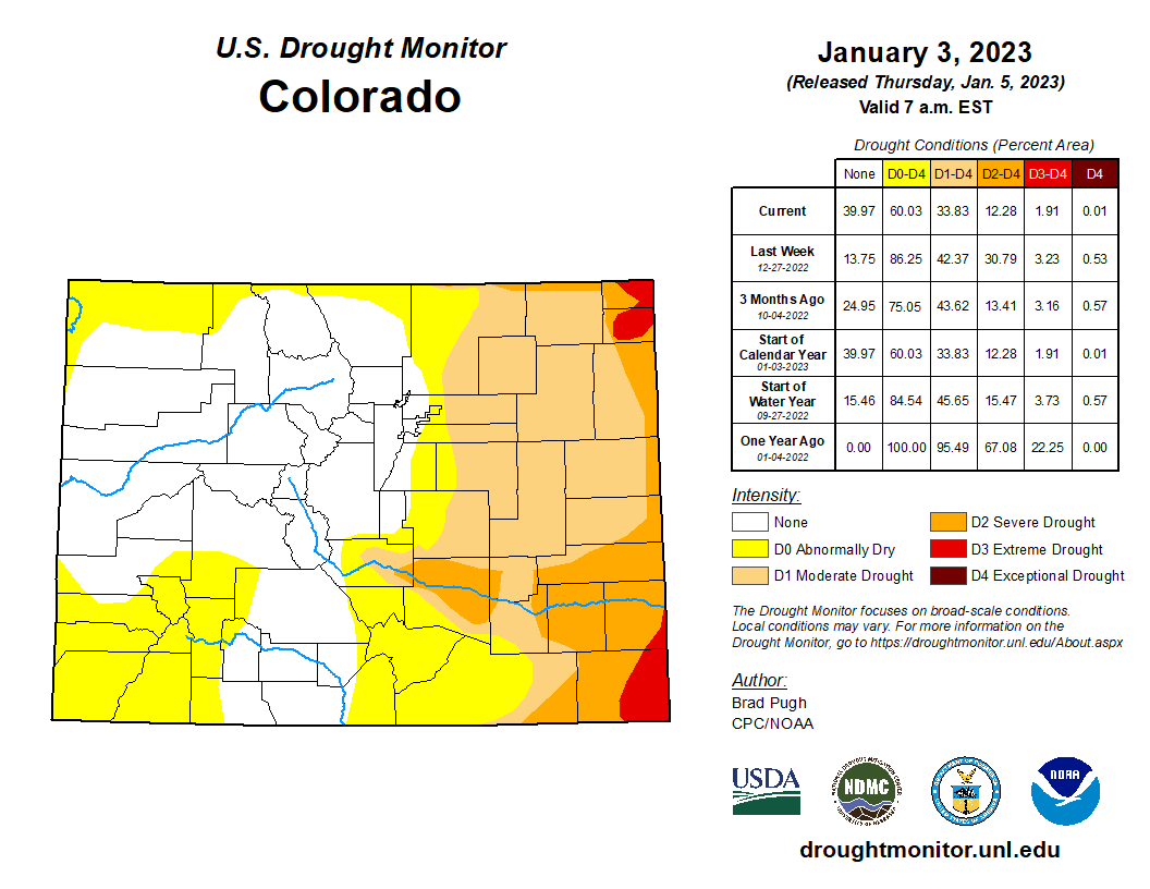
As of Thursday [January 5, 2023] more than a third of the state (most of which sits west of the Continental Divide) is no longer considered to be suffering from drought conditions, according to the U.S. Drought Monitor. The remaining western portions of the state are considered “abnormally dry.”
Colorado Snowpack basin-filled map January 8, 2023 via the NRCS.
Areas around Denver, Boulder and Fort Collins are 117% of normal snowpack levels for this time of year, according to data collected by the U.S. Department of Agriculture’s Natural Resources Conservation Services. Areas around Steamboat Springs sit at 150% of normal, and areas around Aspen, Gunnison and Durango are around 130%, 139% and 125% of normal levels, respectively. Lagging behind is the San Luis Valley at 94% of normal and the southeast portion of the state, which sits at 81% of normal, the data shows.
Click the link to read the post on The Buzz website (Floyd Ciruli):
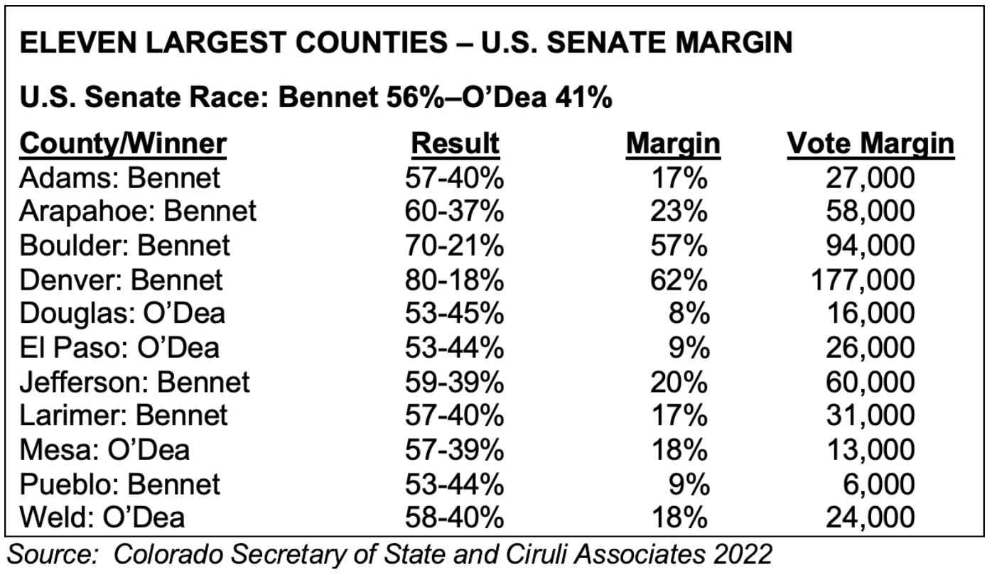
Not only has Colorado shifted to the sapphire “Blue” side of the spectrum, but its counties are being rearranged politically.
The chart below which compares the 15 percent margin in the November election between Michael Bennet and Joe O’Dea in Colorado’s largest counties, shows El Paso and Douglas are becoming more like swing Republican counties providing only modest Republican margins. They are now similar to the formerly strong Democratic Pueblo County, which regularly offers only small Democratic margins.
Denver delivers the biggest statewide vote, even in a lower turnout (67% in 2022 vs 76% in 2018) off-year election ahead of liberal Boulder and the new Democratic strongholds of Arapahoe and Jefferson counties. Among larger counties Republicans still win Mesa on the Western Slope and Weld in the North Front Range.
Among the biggest factors shifting Colorado’s voting patterns were the rapid growth of voters during the last decade (about 1 million voters). They largely settled in the Denver metro area with some overflow in Larimer and Weld in the North Front Range and El Paso in the south. They also primarily registered as unaffiliated. In 2012, unaffiliated voters were 37% or 900,000 voters. In 2022, they were 46%, and 1,734,000 voters. Since 2016, they have been primarily voting for Democratic Party candidates.
According to the US Drought Monitor, drought is at its lowest level in Colorado since October 1, 2019, with just 33.83 percent of the state classified as being in technical drought in this week’s report. This comes after heavy rounds of wet snow hit the state around the turn of the new year. This recent update compares to 42.37 percent of the state being in drought when the report was released last week – nearly a nine percent drop in just seven days. This shift also resulted in a major drop in the Drought Severity and Coverage Index rating, which is now at a 108. The last time this number was that low was also on October 1, 2019, when it was a 97. Between then and now, that number has gotten as high as 398 in late December of 2020 and into the first week of the following year…
It’s also worth noting that 39.97 percent of the state has no drought classification at all, which includes areas in this ‘D0’ level of drought, termed as being ‘abnormally dry’. This number hasn’t been that low since September 7 of 2021.
Updated Colorado River 4-Panel plot thru Water Year 2022 showing reservoirs, flows, temperatures and precipitation. All trends are in the wrong direction. Since original 2017 plot, conditions have deteriorated significantly. Brad Udall via Twitter: https://twitter.com/bradudall/status/1593316262041436160
Click the link to read the article on The Denver Post website (Nick Coltrain). Here’s an excerpt:
Colorado’s top lawmakers spared no superlative in describing the need to address the state’s water crisis at the annual pre-legislative breakfast Wednesday morning. The annual Business Legislative Preview, hosted by the Denver Metro Chamber of Commerce, serves as an unofficial start to the legislative session. While crime, housing, and decarbonization were all discussed, it was water that incoming Speaker of the House Julie McCluskie said would be “the centerpiece” of the legislative agenda.
Senate Majority Leader Dominick Moreno joined McCluskie on the Democratic side of the panel, and incoming Senate Minority Leader Paul Lundeen and House Minority Leader Mike Lynch represented the Republican side. Each side noted the political reality of the upcoming legislative session…
…each side underscored the importance of water and the desire to be part of the conversation. They also noted the complexity of laws governing the resource, other states’ rights — and over-slurping of — water.
“For almost all of us up here, and quite frankly probably most of you folks in the room, this is an issue we don’t have the depth of knowledge we ought to have,” Lundeen said. “Water is critical, it’s not only critical today, but it’s critical to the future of Colorado that our children and grandchildren will live in.”
He warned of the state’s “parched” future if something isn’t done to secure water and pledged his caucus’ engagement on the issue. Lynch likewise said water “will dictate the future of this state.” Each emphasized the need for new reservoirs to store water before it flows out of state.
Editor’s note: Rice Elementary School became the second Wellington school to find elevated copper levels in some of its drinking water sources over PSD’s winter break, according to a district email sent to the school’s staff and families Wednesday. The Coloradoan will continue its reporting on this development.
Poudre School District is investigating the cause of issues with Wellington Middle-High School’s drinking water after two science classes at the school found high levels of copper in it late last year. Following the class tests — which showed levels more than double the Environmental Protection Agency’s action level for copper in drinking water at two water bottle filling stations — PSD took its own water samples from around the school Dec. 22, later confirming through a third-party lab that copper levels in several fixtures and bottle filling stations exceeded the EPA’s threshold, according to a district email to the school’s staff and parents Tuesday [January 3, 2023]…
The Town of Wellington also took samples of its own around the same time, ultimately ruling out the town’s water distribution lines as the cause for the elevated copper levels, the town and PSD both said. While PSD hasn’t yet confirmed what’s causing the elevated copper levels, the general contractor who built Wellington Middle-High School believes the issue could be tied to the newly constructed building’s water softener equipment, according to the district.
The system for irrigating is vastly different between Wyoming and Imperial Valley, and because of this, water negotiators of the region have vastly different points of view. In the Green River Basin, there are 2500 gates diverting water onto ranchers’ lands, but in the greater scheme of things, the basin is essentially a collector system. Some of those far-flung gates are “unregulated,” or unmonitored. The Green River has 2,000 named natural tributaries. Accurately measuring the supply and consumption of water in such a system is a work in progress.
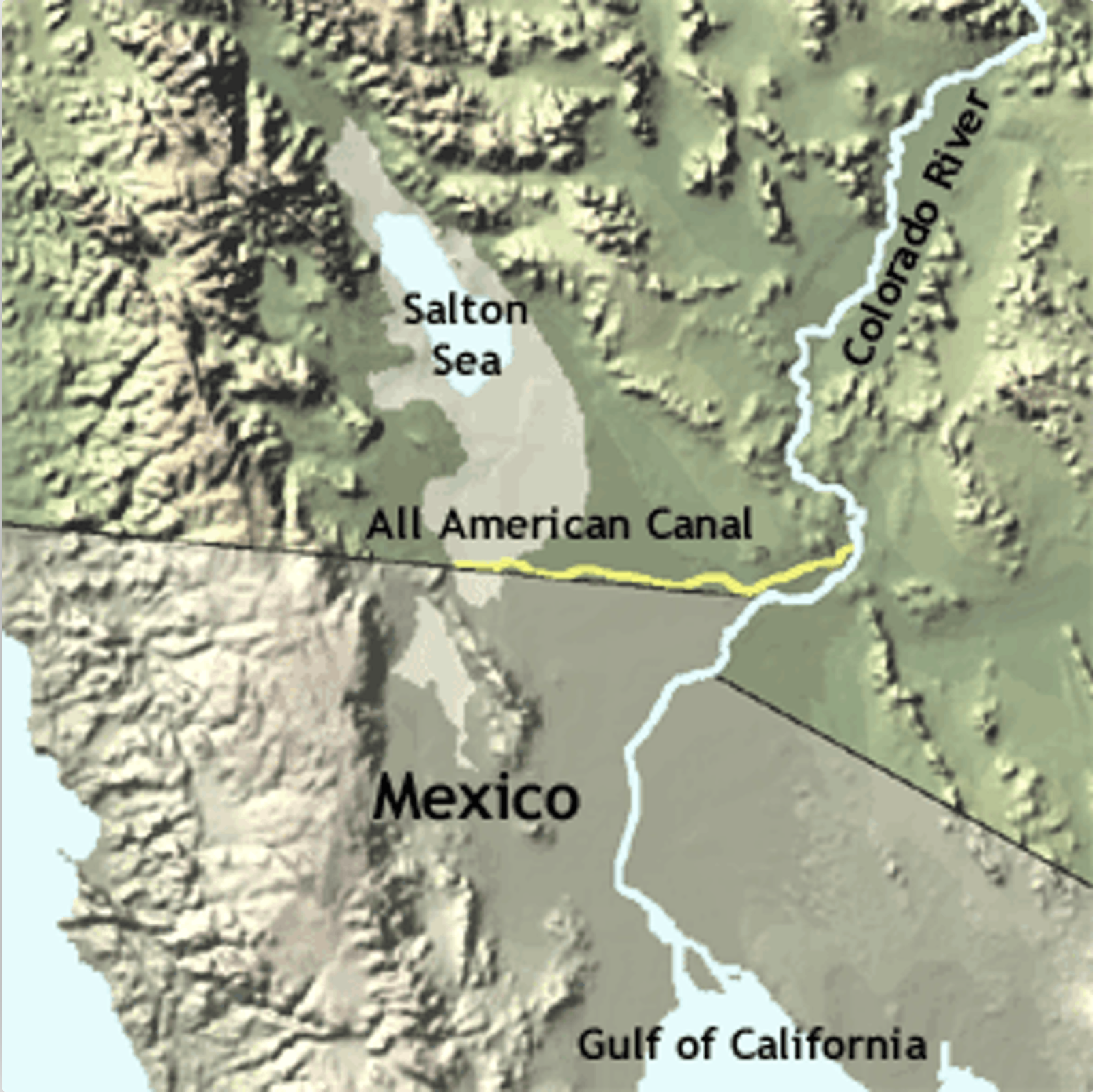
The All American Canal diverts water from the Lower Colorado River to irrigate crops in California’s Imperial Valley and supply 9 cities. Graphic credit: USGS
In the Imperial Valley, we have one gate diverting water from the Colorado River. It is where Imperial Dam turns water into the All-American Canal. While the Green River Basin is a collector system like the roots of a tree, ours is a distribution system like the branches to the leaves. The IID has 5500 gates. Since every one of them is monitored by the IID, water supply and consumption are easy to measure with gauges throughout the system.
Water management is a world apart as well. In the Green River Basin, there are thirty-seven small water distribution agencies, both public and privately owned, often with zero or a handful of fulltime employees. There are irrigation districts, conservancy districts, ditch companies, and canal companies. Ranchers, and often non-agricultural property owners, pay an assessment, or a flat fee, or a per-acre fee, or a price per share for water delivery. The water itself is owned by the state of Wyoming and is made available for free. The overseer of all this is the Wyoming State Engineer, which in turn has a representative on the Upper Colorado River Commission, the governing agencies for the Upper Basin states.
In the Imperial Valley, the Imperial Irrigation District is the sole holder of water rights to Colorado River water and the sole manager for water distribution. Here, as in all the Lower Basin States, the Bureau of Reclamation is our overseer. With nearly 500 employees in its water division, IID outguns the whole state of Wyoming for water workers about 2 to 1. The Bureau also supplies IID’s 3.1 million acre-feet of water for free, and IID charges farmers $20 an acre-foot (af), a fee subsidized by revenue from the transfer of water to the San Diego County Water Authority. Industrial water users pay a much higher fee…
So far, the cuts that Mother Nature has forced on Wyoming and others in the Upper Basin states, and the cuts agreed to by Arizona, Nevada, and California, are far below the amount necessary to save the reservoirs from circling the drain in the next few years. Negotiators have until the end of this month to reach consensus on a plan to satisfy the Bureau of Reclamation’s demand for 2-4 million acre-feet of cuts in water use next year. We’re all unhappy in our own way on the Colorado River. Like the sparsely populated Cowboy state, we can only fight the good fight against the odds.
Atmospheric rivers are long, narrow bands in the atmosphere that transport water vapor, like a river in the sky. When an atmospheric river makes landfall, it often releases this water vapor as rain or snow. Atmospheric rivers are responsible for up to half of California’s annual precipitation, and can cause flood damages averaging $1.1 billion annually throughout the West. Learn more about how atmospheric rivers form, and a scale to categorize their intensity and impacts, in this animation. 0:19 How do atmospheric rivers form? 0:45 What is the atmospheric river scale? 1:05 Why do we research atmospheric rivers? Get atmospheric river forecasts from the Center for Western Weather and Water Extremes (CW3E): https://cw3e.ucsd.edu/ Subscribe to Scripps Oceanography: http://bit.ly/2PVlvmp Subscribe to Scripps’ explorations now newsletter: http://bit.ly/2ZAGhLx Check out Scripps Oceanography: https://scripps.ucsd.edu/ Scripps Oceanography on social: Facebook: https://www.facebook.com/scrippsocean Twitter: https://twitter.com/Scripps_Ocean Instagram: https://www.instagram.com/scripps_ocean
Sites in Archuleta County received between 6.3 and 17.8 inches of snow in the storms be- tween Saturday, Dec. 31, 2022, and Jan. 4, according to the Community Collaborative Rain Hail and Snow Network (CoCoRaHS) website. Higher snowfall totals were concentrated in the northern and southern portions of the county, with the highest reported precipitation amount located east of Chromo, according to CoCoRaHS. A Jan. 4 report from Wolf Creek Ski Area that was issued at approximately 6 a.m. indicated that Wolf Creek had received 11 inches of snow in the previous 24 hours and 59 inches in the last week, bringing the midway snow depth to 83 inches and the season-to-date snowfall total to 154 inches.
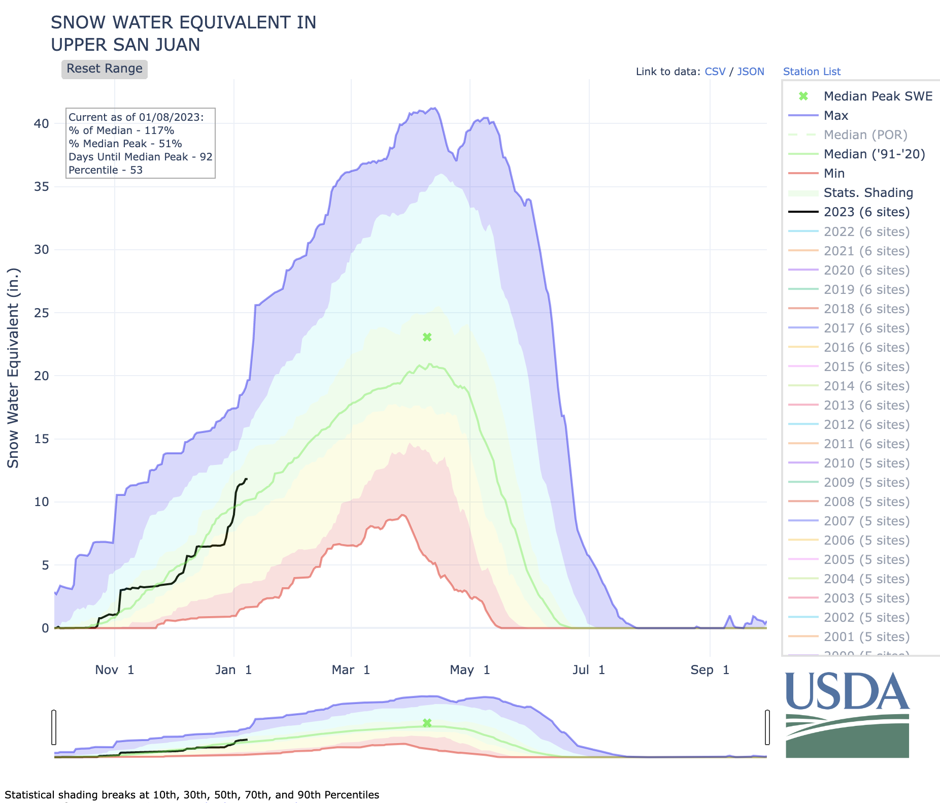
According to the U.S. Department of Agriculture National Water and Climate Center’s snowpack report, the Wolf Creek summit, at 11,000 feet of elevation, had 15.9 inches of snow water equivalent as of noon on Wednesday, Jan. 4. The Wolf Creek summit was at 106 percent of the Jan. 4 snowpack median. The San Miguel, Dolores, Animas and San Juan river basins were at 125 percent of the Jan. 4 median in terms of snowpack…
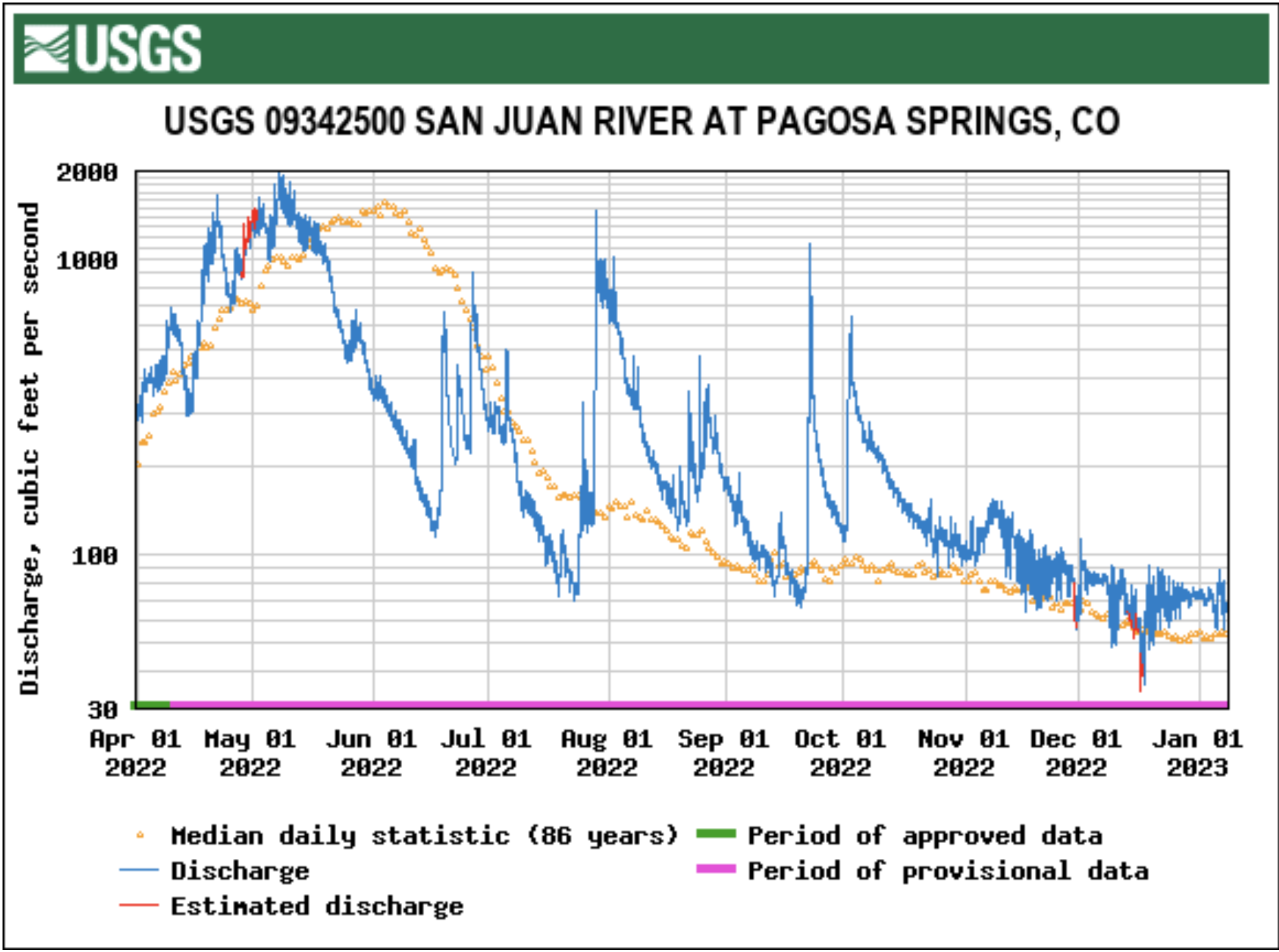
River report
Stream flow for the San Juan River at approximately 10 a.m. on Jan. 4 was 73.8 cubic feet per second (cfs), according to the U.S. Geological Service National Water Dashboard. This reading is up slightly from last week’s reading of 72.5 cfs at 10 a.m. on Dec. 28, 2022.