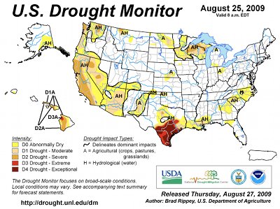
Wow. Click on the thumbnail from the US Drought Monitor and look at Texas.

Wow. Click on the thumbnail from the US Drought Monitor and look at Texas.

From the Fort Collins Coloradoan (Bobby Magill):
The National Ecological Observatory Network, or NEON, is proposing to build two climate monitoring stations at the park. One may be built on the west side of Colorado Highway 7 south of Goblins Castle Road, and the other is being considered for a site in Glacier Creek near the Sprague Lake Picnic Area. At the Goblins Castle site, a 59-foot tower would be built to house monitoring equipment, while water sampling equipment would be installed in Glacier Creek.
More Rocky Mountain National Park coverage here.

From The Greeley Tribune:
The meeting is open to the public and is scheduled for 6:30-8:30 p.m. Sept. 16 at the Gary DeSoto Community Center, 1120 Pawnee Ave. in Sterling. Landowners, agencies, organizations, businesses and residents are invited to discuss water quality concerns and priorities for managing natural and agricultural resources in the Lower South Platte basin. State Rep. Jerry Sonnenberg, R-Sterling, has been invited to speak on the importance of water quality to the economic viability of the entire watershed. Dick Parchini, watershed program manager with the Colorado Department of Public Health and Environment’s Water Quality Control Division, and Cindy Lair, Colorado State Conservation Board program manager, also will be in attendance…
The watershed planning project, funded by the Colorado Department of Public Health and Environment’s Water Quality Control Division through the Colorado Nonpoint Source Program, will encompass an estimated 3.45 million acres from Greeley north and east to the Colorado-Nebraska state line and all or portions of nine smaller tributary watersheds within the planning area.
For more information check out the Lower South Platte Watershed Plan website.
More South Platte Basin coverage here.

Here’s an update on the proposed hydroelectric pumpback project near Penrose, from Chris Woodka writing for The Pueblo Chieftain. From the article:
The project, which would include two small reservoirs near Brush Hollow Reservoir, is still awaiting approval from the Federal Energy Regulatory Commission. Construction is still seven or eight years down the road, Thome said. The project would require about 7,000 acre-feet of water, which would be obtained in a one-time purchase and replenished for evaporation. Water would be pumped to the upper reservoir when energy demand on the grid is lower and run downhill through generators during peak load periods. A total of 320 megawatts would be generated. While the system would be about 76 percent efficient, it would act as a battery to balance power transmission for other renewable technologies when the wind isn’t blowing or the sun isn’t shining, [Steve Thome, spokesman for J-Power USA] said…
The South Slope Project was one of 113 vendors who submitted proposals for Xcel’s plan to meet goals to shift at least 20 percent of its power from coal to wind, solar and other renewable sources. The plan is being evaluated by the Public Utilities Commission, which is expected to make a decision in November, said spokesman Mark Stutz…
The South Slope partners would be looking at a long-term contract that would allow Xcel to operate the hydro plant as needed, rather than simply selling the power on a spot basis…
Natural gas plants are called “peakers” within the industry and are valuable because they can meet peak demand needs, or in the case of renewable sources, supply energy when wind and solar sources go off-line. With a pumpback plant, there would be continued demand for power at night to move the water uphill, Thome explained. “The wind blows day and night in Colorado,” Thome said.

Meeting federal and state standards for E. coli in surface water is very difficult. Sources of contamination need to be identified in order to devise a strategy. The U.S. Geological Survey plans to present their findings from a study of Fountain Creek next week, according to a report from Chris Woodka writing for The Pueblo Chieftain. From the article:
The U.S. Geological Survey will host a meeting at 6 p.m. Sept. 9 at the Pikes Peak Area Council of Governments, 14 S. Chestnut St., Colorado Springs. The study, begun in 2007, focuses on a 12-mile segment of Upper Fountain Creek, from Green Mountain Falls to the confluence of Fountain Creek and Monument Creek.
Possible sources of E. coli that were investigated included cracked sewer pipes, open pipes from wastewater sources, septic systems and animals such as horses, cows, dogs, geese and cats. USGS researchers used molecular microbiology methods known as fecal source tracking to determine whether humans or animals were responsible for contamination.