The Water Infrastructure Network sounds a funding alarm

A picture named fountainpavementdrawing.jpg

From The Denver Post (David Olinger):

WIN-Colorado, an acronym for Water Infrastructure Network, says the unfunded tab for projects statewide has grown $1 billion over two years to $4.3 billion, despite an infusion of infrastructure money from the American Recovery and Reinvestment Act last year. Perry Fowler, a program director at the Associated General Contractors of America, said ARRA brought more federal money for infrastructure work than communities had seen in years but that it still covered a small fraction of their needs. “The situation is not unique to Colorado,” he said. “Everywhere in the country, people are struggling with the problem of paying for water.”[…]

In southern Colorado, Monte Vista faces a different dilemma. The city is relatively poor, its population is shrinking, and it may be unable to finance “projects we desperately need,” said city manager Don Van Wormer.
Monte Vista estimates it will need $48 million, or nearly $10,000 per resident, for future water, sewer and storm projects. It plans to replace water lines throughout the city and repair sewer lines. It wants to connect its two wastewater-treatment plants. And it faces a state order to chlorinate its drinking water, a project of unknown cost.

More infrastructure coverage here.

HB 10-1159: Mitigation for water exports

A picture named coloradotransmountaindiversions.jpg

From The Durango Herald (Joe Hanel):

Geography trumped party when the House Agriculture Committee voted 9-4 Wednesday to approve House Bill 1159 by Pace, D-Pueblo. Pace got support from most Democrats, plus Western Slope Republicans Scott Tipton of Cortez and Randy Baumgardner of Hot Sulphur Springs. Meanwhile, Eastern Plains Republicans and a Denver-area Democrat joined against it. Pace’s “little water bill” would place new requirements on anyone – namely Denver, its suburbs and other Front Range cities – who wants to import water from out of the basin. The bill would require importers to work with water conservancy districts in the basin of origin to figure out a way to compensate for the loss of water.

On the Western Slope, a conservancy district could require the Front Range cities to pay for a new reservoir in the originating basin. On the Eastern Plains, where cities have been buying up farm water rights for years, mitigation could mean payments to school districts for lost tax revenue from the dried-up farms, Pace said. But the bill would not block water transfers. “If I were running the perfect bill, we’d be stopping the transfer of water. This bill does not stop the transfer of water,” Pace said…

“Your ideal bill would be the bill from hell for the Lower South Platte,” said Rep. Jerry Sonnenberg, R-Sterling…

Pace’s bill would send the cities to local water districts to strike a deal, but if an agreement couldn’t be reached, a water court still could impose a solution. But that process could get in the way of longstanding Colorado water law, said Sara Duncan of Denver Water. “This is a very difficult bill to make consistent with the prior appropriation doctrine,” Duncan said.

Meanwhile, The Aspen Daily News’ Brent Gardner Smith caught up with Representative Kathleen Curry to talk about her switch from the Democratic party to unaffiliated late last year. From the article:

So now when the 27 Republicans and 37 Democrats in the House huddle behind closed doors, Curry is left behind, like a nerdy student alone in study hall while all the cool kids are at football practice. But the former Democrat and rancher from Gunnison County doesn’t sound like she minds all that much. “I just feel that voting as a bloc is not how I want to do the job,” she said. “I’m really happy with my decision. And I’m just kind of running my life the way I always have, which is hectic.”[…]

Curry’s legislative effectiveness will be put to the test on Monday when the Judiciary Committee hears her proposed “Commercial Rafting Viability Act,” [HB 10-1188] which seeks to clarify existing Colorado law on whether commercial raft companies can float down a river that happens to run through private land. “There are a lot of people who feel there are two sets of rights,” Curry said. “But I feel we ought to find a way to make it work for both. And I think the committee will give it a fair hearing.”[…]

“I will be voting the way I think is best for my district,” Curry said this week. “If it happens to be Republican, then so be it. I think these bills should be looked at their own merit and not based on how the party votes on them.”

More 2010 Colorado legislation coverage here.

SB 10-027, HB 10-1006 and SB 10-052

A picture named submersiblepump1

From The Yuma Pioneer (Marianne Goodland):

[SB 10-27:] Concerning a Fine For the Unauthorized Diversion of Surface Water] (pdf) is sponsored by Sen. Paula Sandoval, D-Denver and Rep. Ellen Roberts, R-Durango. The committee approved the bill unanimously on January 28 and sent it to the Senate Appropriations Committee for further action. The bill would impose the same fine for illegal diversion of surface water as is in place for illegal diversion of ground water. In a recent interview, Roberts said she and Sandoval were asked to carry the bill by the Attorney General in part to help resolve an issue that went through the courts last year…

Dick Wolfe, state engineer and director of the Division of Water Resources, told this reporter he typically sees between six and 10 complaints per year about illegal surface water diversion and about the same number for illegal ground water diversions. Most surface water complaints arise from situations where the person diverting the water has no water rights at all. The rest come from excess diversions of surface water. Wolfe said most complaints originate in the Arkansas River Basin area, in southeastern Colorado, or in the South Platte River Basin, which covers northeastern Colorado and the Denver metro area. “There is a perception that there is an inequity on enforcement,” Wolfe told the committee last week. “We have relatively good compliance and relatively few violations.”[…]

[[SB 10-052: Concerning the Ability of the Groundwater Commission to Alter the Boundaries of a Designated Groundwater Basin] (pdf), which would make it clear that a final permit for ground water wells in a designated basin is final, sailed through the Senate last week without opposition and is on its way to the House. The bill got final approval from the Senate on January 28 on a 35-0 vote.

Sen. Greg Brophy, R-Wray, is the bill’s sponsor. He told the Senate during debate Tuesday that the agriculture committee, which approved the bill on January 21, had heard from bankers, farmers and community leaders on the necessity for “the surety this bill represents. It’s an important part of everyone’s balance sheets and portfolios.”

While the bill had little opposition in its trip through the Senate, it may face more in the House. Mark Lengel of Burlington, who opposed SB 52 at the January 21 hearing, said he would take his fight to the House and wouldn’t be alone. Lengel said his family has had surface water rights for more than 100 years…

The Division of Water Resources could be spared some of the budget cuts and layoffs anticipated for 2010-11, under a bill approved on January 26 by the House Agriculture, Livestock and Natural Resources Committee. [HB 10-1006: Fund Water Resources Tier 1 Operational] (pdf) was recommended by an interim Water Resources Review Committee that met during the summer. Under the bill the division would receive up to 5 percent of monies from an operational account in the Department of Natural Resources that is funded by severance taxes (taxes generally paid by oil and gas companies to “sever” resources from the land). Bill sponsor Rep. Kathleen Curry, I-Gunnison, told the committee she was trying to find a different source of funding for the division, which is heavily reliant on state general fund dollars…

“My main goal is to make sure the division does not lay off water commissioners, and we shouldn’t have to do that when there are cash funds available in the department,” [State Representative Kathleen Curry] said. The budget cut ordered for the division would eliminate six positions, which Curry said might include water commissioners who inspect wells, issue shut-down orders and collect water and diversion data.

More 2010 Colorado legislation coverage here.

CWCB acquires water for instream flow use on Washington Gulch and the Slate River

A picture named ohbejoyfulslatecreek.jpg

Here’s the release (I couldn’t find a link online):

The Colorado Water Conservation Board approved the acquisition of 5.45 cubic feet per second of water under the Breem Ditch water right for instream flow use in Washington Gulch and the Slate River, two highly visible water-short streams in Gunnison County.

The Breem Ditch water acquisition is the result of a unique, collaborative approach by the CWCB, the Colorado Water Trust, the Skyland Metropolitan District, Verzuh Ranch, Inc., a local development company owned by Billy Joe Lacy and Dan Dow. The CWCB approved the transaction at its January meeting in Denver. “This is a great example of the benefits CWCB’s Water Acquisition Program can provide to our state’s streams through creative partnerships with water users,” said CWCB Director Jennifer Gimbel.

Despite sometimes water-plentiful summers, irrigation demand would often dry up Washington Gulch completely by the middle of July and significantly deplete Slate River flows as well. This transaction will allow Washington Gulch to flow year-round, even during dry summers, and will help fix flow shortages to the Slate River.

After use in the river, the water will be used in Skyland Metropolitan District’s system, which from 2002 to 2004 – Colorado’s most severe recent drought period – was in danger of impairment.

The CWCB will protect the water decreed to the Breem Ditch through the state’s Instream Flow Program on Washington Gulch and about two miles of the Slate River below the confluence with Washington Gulch.

The CWCB is the only entity in the state that can hold instream water rights to preserve and improve the natural environment to a reasonable degree. Under its Water Acquisition Program, the CWCB can acquire water from willing water rights owners by donation, purchase, lease or other arrangement to include in the Instream Flow Program.

The CWCB purchased a portion of the water using funds authorized in 2008 for instream flow water acquisitions, and the Colorado Water Trust donated a portion of the water.

Additional information on the CWCB’s Water Acquisition Program is available on the CWCB web site: http://cwcb.state.co.us/StreamAndLake/WaterAcquisitions/

More CWCB coverage here.

Colorado-Big Thompson update

A picture named coloradobigthompsonmap.jpg

From email from Reclamation (Kara Lamb, February 1, 2010):

It’s that time of year when we begin moving water east to start filling both Horsetooth and Carter reservoirs. For the past several weeks, we’ve been pumping water up to Carter while Larimer County has worked on some recreational improvements at Horsetooth. Currently, Carter is sitting at a water level elevation of 5746 feet—about 13 vertical feet down from full. It should remain at the elevation for a while.

Horsetooth has been rising very slowly over the last several weeks while the recreation work has been going on. We are currently at an elevation of 5384–about 30 feet down from our average fill elevation of 5414.

Today, we turned the pump to Carter off in order to begin sending more water to Horsetooth. Approximately 460 cfs is now going to Horsetooth. Those watching the reservoir water level should notice a sharper rate of increase by the end of the day, tomorrow.

More Colorado-Big Thompson coverage here and here.

HB 10-1159 clears the House Agriculture Committee

A picture named coloradotransmountaindiversions.jpg

From The Pueblo Chieftain (Patrick Malone):

Opponents said Rep. Sal Pace’s proposed law to mitigate economic and ecological impacts of originating communities in water transfers duplicates processes already in place, but the bill passed through committee by a 9-4 vote. Urban water interests and some agricultural voices offered the criticisms Wednesday during a House Agriculture Committee meeting of HB1159, offered by Pace, D-Pueblo…

“There are economic effects when water leaves a community, and there are ecological effects when water leaves a community. There are staggering effects on a community when water leaves it,” Pace said. The inspiration for the bill, Pace said, rests in Southern Colorado history. “The primary need for this bill is the dry-up that occurred in Crowley County in the 1970s,” Pace said, when agriculture was thriving, but the Twin Lakes Canal was sold. “Today, economically Crowley County has the highest poverty rate in the state and the lowest income per capita in the state,” Pace said.

Representatives of the Denver and Aurora water boards, the North Sterling Irrigation District, the South Platte Water Conservancy District and the Northern Colorado Water Conservancy District said the water roundtables created by the Legislature five years ago do an ample job of bringing stakeholders together to address economic and ecological impacts of water transfers. Combined with state and federal rules on ecology and laws that give recourse to water rights owners harmed by transfers, the groups said Pace’s concerns in the bill are already addressed. Water lawyer Peggy Montano called the portion of Pace’s bill that sends unresolved mitigation agreements to water court “planting a litigation garden for the future.”[…]

Jay Winner of the Lower Arkansas Conservancy District, said that group supports the bill. “I think it’s productive to start out with a cooperative relationship,” between originators or destinations of water that’s transferred, he said. Winner said the current water transfer checks and balances work well, and called Pace’s proposal “a parallel course” that in tandem with present protocols could improve them.

Chris Treese, representing the Colorado River District, said the bill would compel parties involved in negotiating water transfers to work out differences that otherwise might never be resolved.

More 2010 Colorado legislation coverage here.

Colorado Springs’ sewer improvements as part of its commitment to Pueblo County in 2009 total $9 million

A picture named fountainpavementdrawing.jpg

From The Pueblo Chieftain (Chris Woodka):

The largest expenditure reported by Colorado Springs was $7.7 million to inspect and rehabilitate sanitary sewer pipes less than 10 inches in diameter. About 20.5 miles of pipe were repaired or rehabilitated under this year’s program.

Other expenditures included:

Repair of 131 manholes at a cost of $413,000.
Repair or enlargement of 3,741 feet of pipelines greater than 10 inches in diameter.

The inspections and repairs reduce the risk of sewer spills or overflows, the report states.

Meanwhile the Colorado Water Quality Control Commission is stirring up controversy with their plans to possibly list Fountain Creek as only seasonally impaired for E.coli and delist it for selenium, according to Chris Woodka writing for The Pueblo Chieftain. From the article:

If approved, that would remove some limits on effluent put into Fountain Creek and further harm water quality, say groups opposing the move. “Their position is that the waterway will always accept more effluent,” said Joe Santarella, attorney for the Rocky Mountain Environmental Labor Coalition and Sierra Club. “There is no incentive for dischargers to meet TMDL limits.”

TMDL — total maximum daily load — on any pollutant is a standard adapted under Section 303(d) of the federal Clean Water Act to ensure that levels in an impaired stream do not become worse. The state’s action would relax the need for sewer dischargers to meet such levels, Santarella said. “State regulation has rendered the 303(d) process meaningless,” he said.

Pueblo District Attorney Bill Thiebaut is joining the environmental groups in opposing the state Division of Water Quality Control recommendations on Fountain Creek.

The Water Quality Control Commission will have a hearing on recommendations on streams statewide beginning at 9:30 a.m. Monday at state Department of Public Health and Environment offices, 4300 Cherry Creek Drive South, Denver…

The data used to make the determination show that overall, Fountain Creek E. coli is just below year-round levels for E. coli impairment, but reaches double the acceptable level from May to October. After challenges to the methodology, the division revised the seasonal limits to January to October on the reach above Pueblo instead. “The WQCD fails to explain what would be accomplished by eliminating two months (November and December) from the current annual impairment listing. In fact, nothing beneficial would be accomplished. Instead, the WQCD’s proposal would only confuse the general public and pose a risk to public health,” John Barth, Thiebaut’s attorney, noted in comments to the commission.

Colorado Springs Utilities attorney Richard Griffith supports the initial state recommendations, arguing recreation is not likely to occur during the winter months. “Utilities supports the seasonal listing methodology because recreation is most likely to occur during the warmer months of the year and impairment evaluation of E. coli data limited to those months can reveal impairment which may not be evident when calculated on an annual basis,” Griffith said.

In its comments, the Environmental Protection Agency supports seasonal limits, but warned against increases of flow. “EPA believes that it would be unwise to allow any new or increased discharges outside of the seasonal window (whatever season that is determined to be) that would result in the attainment in the E. coli standard,” said Karl Hermann, of the Region 8 water quality unit…

The state also is ignoring a Colorado State University-Pueblo study of how living plants along Fountain Creek absorb pollutants because it is still in progress. That could be the crux of future water quality problems on Fountain Creek, Vincent said.

More Southern Delivery System coverage here and here. More Fountain Creek coverage here and here.

Cortez: City council approves $525,000 loan application for water treatment plant upgrades

A picture named watertreatment.jpg

From the Cortez Journal (Steve Grazier):

City Manager Jay Harrington said the loan amount, which is not to exceed $525,000, with the Colorado Water Resources and Power Development Authority – via the newly formed Cortez Water Enterprise – is tapped for improvements at the older water treatment plant. “Basically, we’re looking at funds to replace the old filter media (system),” Harrington said. “It’s a pretty aged section.”

An existing 22-year-old multimedia filter plant that has a lifespan of 15 years needs a major overhaul, Harrington said. The facility is located just north of Cortez at 27999 County Road N. The loan with the state comes with a 2 percent interest rate and is a 20-year agreement, Harrington said. Upgrades to structure include installing six multimedia filter-to-waste valves, repairing a backwash system and updating operating software and filter-control instruments to improve surface wash, according to the city’s water plant superintendent, Bruce Smart…

Work at the water treatment facility likely will begin this spring and conclude in October or November, Smart said. The upgrade project is scheduled to go to bid next week.

More water treatment coverage here.

La Plata-Archuleta Water District to allow residents to opt out of new district

A picture named waterfromtap.jpg

From The Durango Herald (Dale Rodebaugh):

“This isn’t new,” water district president Dick Lunsford said by telephone. “This is the third chance people have had to drop out.” The first chance was before a hearing of La Plata County commissioners. The second opportunity was before a court hearing, Lunsford said. The latest mailing doesn’t go to all residents because some homeowners already have removed their property from the district. “We’re trying to be fair,” Lunsford said. “Some people may not need water now, but they could come back in later without a penalty.” The deadline for returning the [opt out] letter is March 15, he said…

District board members could schedule a mill-levy election, perhaps in May, to fund the district, Lunsford said. The levy would be 5 mills on assessed valuation, he said. The district in September postponed a November election because of anti-tax sentiment and the weak economy. A brochure distributed by the district last year estimated the property tax on a $250,000 house would be $8.25 a month or $99 a year. The district won a $400,000 grant from the Colorado Water Conservation Board last September to further develop the project. Harris Water Engineering of Durango is working on a district master plan.

More infrastructure coverage here.

Energy policy — coalbed methane: Landowners mulling filing for water rights after industry filings surface

A picture named nontributarycoalbedmethane.jpg

Here’s a call to arms of sort from the Director of the San Juan Basin Citizens Alliance, Megan Graham, via The Durango Herald. She is recommending that landowners get educated quickly about filing for water rights under their land now that the oil and gas operators in the area are filing for decrees as a result of the new rules for coalbed methane produced water from the State Engineer. From the article:

The map defining the two, issued by the state engineer’s office, has raised some questions in that it was based heavily on input from industry. But what has gotten even more attention is a blizzard of water-rights filings by industry on the water in question: rights that would trump those of the overlying surface owners who had not previously sought their own adjudicated water right. The nuances of this scenario are many, and landowners on whose property these rights have been filed understandably are full of questions about what the filings mean for their water and land.

There are larger questions, too, about what the industry is up to. Seeking legal, and arguably unnecessary, claim to thousands of acre-feet of water – albeit often brackish and of questionable use – without permission of the overlying landowner is hardly neighborly, and raises eyebrows at the very least. It also raises a number of legal issues that will be keeping water attorneys busy for the next several months, at a minimum. And that leaves aside, for the moment, the question of augmentation plans for the water deemed to be tributary.

In the meantime, though, landowners who received notice of a water-rights filing – tributary or nontributary – would be wise to educate themselves about what is at stake in their particular circumstance. Those with an adjudicated right or a ditch right, for example, might take a different course of action than someone who has no property rights to the water in question.

There are a number of options on how to proceed, and determining the best one requires diligence and access to knowledgeable resources. Fortunately, there are many of these available to help sort through this inherently murky situation.

More coalbed methane coverage here and here.

Salida: Greater Arkansas River Nature Association to host Sense of Place Program on weather in the Upper Arkansas Valley February 8

A picture named cloudswiki.jpg

From the Salida Citizen:

Clouds and the weather is the topic of GARNA’s next Our Sense of Place program on Monday, February 8. Dr. Stanley L. Barnes will lead a presentation on what it takes for clouds in the Upper Arkansas Valley to form, the role of water vapor and its source, and why some clouds move with the winds and others do not…The program will begin at 7:00 PM at the Salida Community Center, 3rd and F Streets. The cost is free for GARNA members and $5 for non-members. Please call GARNA at 719-539-5106 for more information.

More education coverage here.

Snowpack news: Blue River watershed at 71% of average

A picture named coloradosnowpack020210

From the Summit Daily News (Robert Allen):

With less snowfall this winter, snowpack for the end of January is about 71 percent of average in the local Blue River Basin area, according to data from the USDA Natural Resources Conservation Service. The Colorado River headwaters region runoff forecasts range from about 65 to 75 percent of normal, said Mike Gillespie, snow survey supervisor with the Conservation Service…

He said El Niño is likely to blame for this winter’s weather patterns. “Those January storms were pretty much a classic pattern for what we expect (with an El Niño system) that really pounds California, Arizona and New Mexico,” Gillespie. “We get lucky in the San Juans, but it doesn’t really get north of there.”

But the situation could be worse if reservoir levels weren’t as high. At the end of December 2009, the Dillon Reservoir level was 107 percent of average, according to the NRCS website at www.wcc.nrcs.usda.gov.

More snowpack news from Bill Jackson writing for The Greeley Tribune. From the article:

Statewide, water content of the snowpack was 86 percent of average and 73 percent of last year’s snowpack totals, according to Allen Green, state conservationist. The increased totals across southern Colorado were essentially offset by the decreases in percentage across the central and northern basins, Green said in a press release. That has resulted in the same statewide snowpack percentage for two consecutive months.

More coverage from The Denver Post (Yesenia Robles):

According to the latest snowpack report from the Natural Resources Conservation Service, Colorado basins were at 86 percent of average as of Monday. The percentage is the lowest since 2003.
Catching up to average snowpack levels becomes more of a longshot each month. “We need 125 percent of average snowfall for the next 2½ months,” said Mike Gillespie, snow-survey supervisor with the NRCS…

The basins need more than 30 inches each month to catch up. Snowpack levels are below average in every Colorado river basin. Only the San Juan, Animas and Dolores basins are close to average levels…

Gillespie blamed the El Niño weather pattern. “Typically, storm tracks enter further south, mostly into Arizona and New Mexico,” Gillespie said. He said snowpack levels in those states are being reported in some areas up to 300 percent of average. Another trend during El Niño years is to see a few big storms later in the season that make up for the dry months of winter. “During this kind of a year, it’s very typical,” Gillespie said. “In 2003, also an El Niño year, we saw the blizzard of March 2003 that brought many feet of snow in Denver. It caught us up to average.”

La Junta: Lower Arkansas Watershed Input Forum

A picture named arkansasriverbasin.jpg

Here’s a release from the National Resources Conservation Service via the La Junta Tribune Democrat:

The Lower Arkansas Watershed is a partner of the Natural Resources Conservation Service and is working with the agency to host the 2010 Lower Arkansas Watershed Conservation Input Forum. The meeting will be from 10 a.m. to 2:30 p.m., Tuesday, Feb. 23, at Otero Junior College in the Student Center banquet room. The Student Center is at 2001 San Juan Ave. (west entrance). The handicapped entrance is at 5 Western Ave. (east entrance).

This meeting is designed to provide participants the opportunity to help guide and make recommendations regarding NRCS assistance with some of the most pressing natural resource concerns within the community through its technical and financial programs and activities. Don’t miss this important opportunity to contribute to the conversation as the wise use and conservation of our natural resources is everyone’s responsibility and is critical to sustaining and enhancing the quality of life enjoyed in the community. “It’s vital that citizens and partners of NRCS help guide and provide input to the agency to help ensure its programs and activities reflect and help support the needs of local natural resource concerns,” says Leroy Brase, president of the Lower Arkansas Watershed Association.

For information contact John Knapp, NRCS area conservationist in La Junta at john.knapp@co.usda.gov, or by calling (719) 384-5408, extension 106. Call (719) 384-5408, extension 3, by Thursday, Feb. 18, to RSVP so that organizers have numbers for lunch.

More Arkansas River Basin coverage here.

Two Rivers Water acquires majority interest in the Huerfano-Cucharas Irrigation Co.

A picture named huerfanoriver1

From the Denver Business Journal:

Two Rivers said it has completed the purchase of 55 percent of the outstanding shares of Huerfano-Cucharas Irrigation (HCIC) through Two Rivers’ 50 percent-owned joint venture, HCIC Holdings LLC. It also said it has separate agreements to purchase an additional interest in HCIC to bring its total ownership to 90 percent by April…

The acquisition “gives Two Rivers the opportunity to now move forward in the repair of the Cucharas Dam and Reservoir, one of Colorado’s largest on-stream reservoirs,” John McKowen, Two Rivers chairman and CEO, said in a company statement. The reservoir is located in Huerfano County in southeast Colorado. “The Cucharas Reservoir, when restored, has 55,000 acre feet of storage capacity, which can be rebuilt for less than $375 an acre foot, compared to a current cost of construction of over $3,000 an acre foot for other large capacity reservoirs,” he said.

More infrastructure coverage here.

CWCB: Supporting docs for the Colorado River Water Availability Study

A picture named leechpool.jpg

All of you numbers junkies will love the Colorado Water Conservation Board’s supporting documentation for the Colorado River Water Availability Study.

More Colorado River Basin coverage here.

Snowpack news: Upper Colorado River Basin at 65%

A picture named coloradosnowpack020210

From the Sky-Hi Daily News (Matt Barnes):

Snowpack in the high-elevation mountains above Middle Park now ranges from 43 percent to 92 percent of the 30-year average, with the highest readings on the east side of the valley, and the lowest readings on the north side. This is very similar to, and on average slightly less than, 2002 — the driest Feb.1 since 1981 (when snowpack was a scant 40 percent of average). Snowpack for the total Colorado River Basin within the state of Colorado is slightly above 2002 levels. Snow density is averaging 22 percent, which means that for a foot of snow there are 2.6 inches of water.

From The Aspen Times:

…the Roaring Fork watershed’s snowpack slipped from 85 percent to 83 percent during the month, according to a report released Wednesday…

Colorado’s weather is considerably drier this winter than last winter, the report said. The statewide snowpack is just 73 percent of last year’s snowpack at the same point in the season. The Jan. 1 and Feb. 1 snowpack levels were the lowest since 2003, the report said…

In the Roaring Fork basin, the snowpack in the Fryingpan Valley is particularly low, the conservation service data showed. The level at Nast Lake, at an elevation of 8,700 feet, was only 55 percent of the long-term average. At the Kiln site farther up the valley, the snowpack was only 59 percent of average. At Ivanhoe, a lake at 10,400 feet in elevation, the snowpack was 82 percent of average. The Crystal River Valley also lost the healthy snowpack it had stockpiled earlier in the season. The North Lost Trail area near Marble had a snowpack 78 percent of average. At McClure Pass it was 83 percent of average and at Schofield Pass it was 98 percent of average. The conservation service said its computerized Snotel site half-way between Aspen and the summit of Independence Pass was at 92 percent of average. The Aspen-area snowpack compared favorably to many parts of the state as of Wednesday. Copper Mountain was at 66 percent of average while Vail Mountain was at 68 percent of average, the conservation service’s data showed. Hoosier Pass near Breckenridge was at 84 percent of average while Rabbit Ears near Steamboat Springs was at only 53 percent of average. Snotel sites near southwest ski areas showed heathier snowpacks. Wolf Creek summit was at 115 percent of average while Lizard Head Pass outside of Telluride was at 111 percent.

Monte Vista residents get to cough up more dough for water, sewer and stormwater capital improvements

A picture named sandhillcrane.jpg

From The Monte Vista Journal (Dianne James):

Water rates: Due to the costs for thawing and repair of water lines, the city of Monte Vista is amending the current water rate structure.

Sewer rates: The City reported that wastewater revenues have decreased by approximately 8.8 percent compared with 2008, and the city anticipates a decline in water usage and wastewater fee revenue. The city said in the resolution,“Increases in costs have also resulted from capital requirements, maintenance of equipment and rising business costs. Projections indicate that sewer operations will operate in a deficit without an amended rate structure.”

Storm drain maintenance: The current storm drain base fee is $.50 charged to each account within the city limits, a fee adopted back in 2001 and which was supposed to increase each year by the same percentage as the cost of living increase applied to city personnel, however, according to city records, the increase was never implemented.

More infrastructure coverage here.

$3 million for the Arkansas Valley Conduit shows up in President Obama’s budget

A picture named puebloreservoir.jpg

From the La Junta Tribune Democrat:

The Conduit was originally authorized in 1962 as part of the Fryingpan-Arkansas project. It got its initial $5 million from the federal government last year and that money will be spent during the next two and a half years on the Environmental Impact Statement.

“This project has been on the back burner for over four decades,” said [U.S. Representative John Salazar]. “I have been working hard to push it to the front burner and I’m glad that President Obama has recognized that generations of Southeastern Coloradoans have waited too long for a reliable water delivery system. With this funding, we will put hard-working Americans to work repairing our aging infrastructure and we will provide clean and safe drinking water for generations to come.”

“Water sustains our farms, our families and our communities in Southeast Colorado,” said U.S. Representative Betsy Markey]. “This project has been a long time coming, and I’m happy to see this funding in the budget. Construction of the conduit will not only help ensure clean, reliable water in the future, but it will put Coloradans to work today.”

More Arkansas Valley Conduit coverage here and here.

Energy policy — coalbed methane: La Plata County Informational meeting on the State Engineer’s new coalbed methane produced water rules tonight

A picture named nontributarycoalbedmethane.jpg

Here’s a recap of yesterday’s informational meeting, from Katie Burford writing for The Durango Herald. From the article:

State water officials were at Bayfield High School on Tuesday evening to provide information about a water case decided last year by the state Supreme Court and related to recently passed legislation. After nearly three hours of presenting and answering questions, more questions were still rolling in from the approximately 125 people in attendance. “I know people have a lot of concern,” said John Cyran, head of the water-resources unit at the state Attorney General’s office.

The most contentious issue at Tuesday’s meeting was a map released last month by the state Engineer’s Office showing where water is considered tributary – meaning it feeds into streams – and where it is not. Generally speaking, tributary wells were closer to the Fruitland Outcrop – where the lip of the San Juan Basin curves to the surface in an arch across La Plata County. Meanwhile, deeper wells farther out in the basin toward New Mexico were mostly nontributary…

State law gives nontributary water to both landowners and gas operators, so long as operators are using it specifically for mining. But only water court can grant either of them an adjudicated right to the water. The fact that gas companies are speaking up for the nontributary water by filing applications in water court had residents at the meeting asking if they should do the same. State officials said to have standing in the case, residents, too, must file for a right in court. Once they have a pending application before the court, they can file an objection, which is due by the end of the month. “You’ve got to show you’ve got a dog in this fight,” Cyran said.

Here’s the link to the proposed rules from the Colorado Division of Water Resources website.

More coalbed methane coverage here and here.

HB 10-1188: Clarify River Outfitter Navigation Right

A picture named raftingarkriver.jpg

Here’s the background story that led to Representative Curry’s bill, from Jessica Fender writing for The Denver Post. From the article:

A band of lawmakers has waded into the long-standing debate on whether rafters have the right to float through private property in an attempt to change ambiguous laws to favor rafters. Without legislative action, any one of the state’s 160 rafting companies could be the next sued out of business as stretches of river they once traveled are blocked off, said Mark Schumacher, who has run the Three Rivers Resort rafting operation on the Taylor since 1983. “Our fear is if they filed a civil trespass charge against us and win, it will set the precedent and any landowner on any river who doesn’t want people to float through (will follow),” Schumacher said. “The well- to-do, elite landowners are like Goliath. We’re like David.”[…]

[HB 10-1188] It’s scheduled for its first hearing Feb. 15, according to its sponsor, unaffiliated Rep. Kathleen Curry of Gunnison…

Lawyer John Hill represents Jackson-Shaw and said if the state legislates in favor of the rafters, they’ll have to pay landowners’ compensation for lost land value and business. “The public has no right to float through private property without the consent of the landowner,” Hill said. “That’s the law. You can’t change that without paying just compensation.”

The courts and the legislature decades ago decided and re-decided the right-to-float issue on the criminal side, and it’s not a crime to pass through private property on a river. But in the past three decades, there has been no such definitive answer for whether floaters can be sued for civil trespass if they float through private land…

Steve Roberts’ voice quivers with frustration as he talks about the land his family has operated — Harmel’s Ranch Resort — for more than a half century. It’s home to a fishing resort where he’s dropped more than $100,000 on river improvements to build up his stock on the three-quarters of a mile of the Taylor next to the Jackson-Shaw development. Roberts worked out a compromise with Schumacher, but the other nearby rafting crew floats big groups through his land twice a day, sometimes disrupting fish and upsetting Roberts’ clients, he said. “They’re splashing the water, going ‘whee!’ over the dams I created when I improved the fishing. They’ve hit the bridge with paddles,” Roberts said “So here I am, getting overrun with trespassers because trespassing is popular.”

More 2010 Colorado legislation coverage here.

Snowpack news

A picture named coloradosnowpack020210

From The Pueblo Chieftain (Chris Woodka):

The moisture content for the snowpack statewide was 85 percent of average, according to the Natural Resources Conservation Service Snotel network. That’s an improvement — just barely — from 75 percent two weeks ago. “It’s not encouraging so far, so hopefully we’ll get caught up,” said Alan Ward, water resources administrator for the Pueblo Board of Water Works. “We’re kind of running out of time.”

In the Arkansas River basin, snowpack was 88 percent, and the Colorado River basin, which provides imported water, was 75 percent of average on Tuesday, according to the NRCS…

The Pueblo water board has kept track of snow depths on its ditches for the past four years — too short a time for historical comparison. The readings however, indicate the snowpack is off to a slow start, Sexton said. For instance, on the Wurtz Ditch on Tennessee Pass, [Rick Sexton, caretaker for the Pueblo water board’s Clear Creek Reservoir] measured 37 inches of snow, compared with a 46.7 inches average the last few years. Water content of the snow was 8.1 inches this year, compared with 12.4 inches average…

Streamflows in the Arkansas River are average nearly everywhere for this time of year. The flow through Pueblo is staying at 100 cubic feet per second through flow agreements, while some winter water continues to be stored in Lake Pueblo. Reservoir storage levels throughout the basin are good, with some space being cleared over the winter months in Turquoise and Twin Lakes by running water into Lake Pueblo.

Fort Morgan: Meeting to review proposed wastewater regulations February 4

A picture named fountainpavementdrawing.jpg

From The Fort Morgan Times:

The meeting will be held at 1 p.m. in the large meeting room at the Morgan County Administration building at 231 Ensign St.

More wastewater coverage here.

Benefits of controlled flood in Grand Canyon are short-lived

A picture named glencanyondam030508

Here’s the release from the USGS:

Resources along the Colorado River in Glen Canyon National Recreation Area and Grand Canyon National Park generally benefited from a high-flow experiment conducted in March 2008 from Glen Canyon Dam, near Page, Ariz., according to research findings released today by the U.S. Geological Survey.
The 2008 experiment, designed to mimic natural pre-dam flooding, tested the ability of high flows to rebuild eroded Grand Canyon sandbars, create habitat for the endangered humpback chub, and benefit other resources such as archaeological sites, rainbow trout, aquatic food for fish, and riverside vegetation.

Before the dam’s completion in 1963, spring snowmelt produced floods that carried large quantities of sand that created and maintained Grand Canyon Sandbars. Today, because Glen Canyon Dam, which provides hydropower to customers in six States, traps approximately 90 percent of the sand once available to maintain Grand Canyon sandbars, high flows are the only way to rebuild these important resources.

The studies’ key findings follow:

— The 2008 experiment resulted in widespread increases in the area and volume of sandbars, expansions of camping areas, and increases in the number and size of backwater habitats (areas of low-velocity flow thought to be used as rearing habitat by native fish).

— Six months after the experiment, the new sandbars had been largely eroded by typical fluctuating flow dam operations driven by electrical energy demand; however, median sandbar elevation was still slightly higher and backwater habitats still slightly more abundant than before the experiment. Although stable and relatively lower monthly volume releases are the most effective at limiting sandbar erosion, the volume of water that must be released from Glen Canyon Dam annually is determined by basin hydrology and legal requirements to deliver water from the upper to lower Colorado River Basin.

— Timing the 2008 experiment in March likely reduced successful nonnative seedling germination and created new sandbars during the spring windy season, which allowed for the greatest transport of windblown sand to archeological sites where it protects sites from weathering and erosion.

–In the Lees Ferry rainbow trout fishery, high flows reduced the New Zealand mud snail population by about 80 percent. This nonnative species is considered a nuisance species because the snails cannot be digested when eaten by trout. In contrast, midges and black flies, high-quality food items for fish, increased.

–Young rainbow trout in the Lees Ferry river reach had better survival and growth rates following the experiment, which scientist think may have resulted from improved habitat conditions and better food quality. Additionally, data show that rainbow trout did not move downstream in significant numbers as the result of the high flows.

“Insights gained about the effects of the 2008 experiment will be invaluable in helping decision makers determine the best frequency, timing, duration, and magnitude for future high flows to benefit resources in Glen Canyon National Recreational Area and Grand Canyon National Park,” noted John Hamill, Chief of the USGS Grand Canyon Monitoring and Research Center.

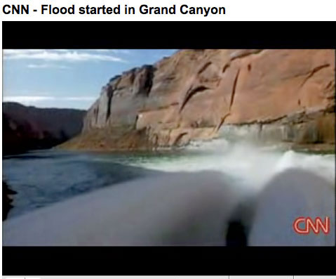
On March 5, 2008, the Bureau of Reclamation began a 60-hour high-flow experiment at Glen Canyon Dam. Water was released through the dam’s powerplant and bypass tubes to a peak of about 41,500 cubic feet per second, about twice the normal peak. Two previous experiments were conducted in 1996 and 2004.

Research completed by the U.S. Geological Survey and cooperating scientists about the effects of the 2008 high-flow experiment will be discussed at the Glen Canyon Dam Adaptive Management Program meeting February 3–4, 2010, in Phoenix, Ariz. The findings will also be taken into consideration in development of a new protocol for conducting additional high-flow experiments, announced by Secretary Salazar in December 2009.

The USGS Southwest Biological Science Center’s Grand Canyon Monitoring and Research Center is responsible for scientific research and monitoring activities for the Glen Canyon Dam Adaptive Management Program, which is administered by the U.S. Department of the Interior. Research activities are undertaken in close cooperation with a wide range of federal, State, and tribal resource management agencies; academic institutions; and private consultants.

A USGS Fact Sheet summarizing the results of the 2008 high-flow experiment is available online.

More coverage from the Associated Press (Felicia Fonseca) via the Deseret News. From the article:

Interior Secretary Ken Salazar has called for more of the man-made floods. A plan on when and how such high-flow experiments should be conducted will be based partly on the USGS report released Tuesday.

More Colorado River Basin coverage here.

Snowpack news

A picture named coloradosnowpack02012010

From The Greeley Tribune (Bill Jackson):

While most areas of the Poudre Canyon snowpack is well below the long-term average and readings from a year ago, one survey field at Deadman Hill, which is at 10,220 feet in elevation, is well ahead of previous readings. In the Big Thompson, readings are near average, with the exception of Hidden Valley, at 9,480 feet, which is about 35 percent below average. “That illustrates the hopscotch nature of snowstorms,” [Brian Werner, spokesman for the Northern Colorado Water Conservancy District] said. On the Western Slope, the snowpack in the upper Colorado River where the C-BT gets its water to bring to the east side is 75 percent of average, Werner added…

Werner said storage in northern Colorado reservoirs is excellent going into the spring and summer months. Storage in C-BT reservoirs, he said, is 15 percent above average, while storage in farmer reservoirs throughout the region is 36 percent above average.

Water Utility Climate Alliance: Decision Support Planning Methods: Incorporating Climate Change Uncertainties into Water Planning

A picture named spainsunflower.jpg

Here’s the release from WUCA:

The Water Utility Climate Alliance released a white paper today that outlines planning approaches to help water utilities adapt to climate change. Planning methods are necessary because many water utilities cannot afford to delay significant decisions and wait until the range of potential climate change impacts is substantially narrowed.

The report, Decision Support Planning Methods: Incorporating Climate Change Uncertainties into Water Planning (pdf) was produced to help water utilities consider and evaluate traditional and emerging planning techniques for use in their own climate adaptation efforts. Integrating climate change information into water utility planning is one of the most intricate aspects in the climate change adaptation process and this paper will help water utilities identify the method(s) most suitable for their planning needs.

“Climate change is shaking up our fundamental water planning assumptions,” said Chips Barry, manager of Denver Water. “Many agencies will need new planning techniques to address uncertainties associated with climate change. This white paper is a guide for those water utilities. We hope it will lead to a greater use and refinement of these methods,” said Barry.

The report found that there are few examples of applying these methods specifically to climate change planning. WUCA encourages collaboration on the development of water utility case studies that document the use and application of these methods.

For more information about WUCA, or to access a copy of “Decision Support Planning Methods: Incorporating Climate Change Uncertainties into Water Planning,” visit http://www.wucaonline.org.

Thanks to Denver Water (Stacy Chesney) for the link. Here’s their release.

More climate change coverage here and here.

HB 10-1159, HB 10-1188, HB 10-1190 and SB 10-052

A picture named coloradotransmountaindiversions.jpg

Here’s an analysis of the 3 House bills, from Joe Hanel writing for the Cortez Journal. From the article:

Lawyers, rafts and money. Those are the debates in store for Colorado’s water community this year at the Legislature. A Pueblo Democrat wants to make sure that water imports from wet basins to dry ones don’t harm people in the original basin. And a Gunnison representative wants to make sure rafting guides can float the state’s rivers, no matter who owns the riverbank. Both bills, though, could be overshadowed by the money crunch, which could hit irrigators and water users just as hard as the rest of the state.

More coverage from the Yuma Pioneer (Marianne Goodland). From the article:

The first water bill of the 2010 session got its first hearing last Thursday, January 21. The Senate Agriculture and Natural Resources Committee voted 6-1 to approve SB 10-52, which would make it clear that a final permit for ground water wells in a designated basin is final. It is on the Senate calendar for further debate in the Senate this week. SB 52 is sponsored by Sen. Greg Brophy, R-Wray and Rep. Kathleen Curry, I-Gunnison. Brophy said this week that SB 52 is designed to provide assurance for people who own large capacity ground water wells that those wells cannot be pulled out of the designated basin area. Under SB 52, the Ground Water Commission, which manages the eight designated basins along the eastern plains and the Front Range, could revise the basin’s boundaries to remove previously-included areas only if the area does not include wells that have had final permits issued…

Michael Bohnen of Bethune testified that his family’s surface water rights on the Republican River date back to 1904 and likened the bill to eminent domain. “Well users can pump the river dry,” he said. “Every well in the basin affects the flow of the river.” However, when questioned by Sen. Bruce Whitehead, D-Hesperus, both said they or their families did not object when the original boundaries were drawn back in the 1960s and 1970s.

Steve Sims, former water counsel for the attorney general and now with Brownstein, Hyatt & Farber, testified that senior water rights in the basin are not based on flowing streams and there would be no quantifiable injury to those surface water rights holders. SB 52 also provides strong language on the intent of the legislature regarding challenges to ground water well permits. The bill says that after a certain amount of time has passed, any request to pull out a well for which a permit has been issued should be considered a “collateral attack” on the original designation of the basin. However, the bill does not specify how long that time should be.

More 2010 Colorado legislation coverage here.

Energy policy — nuclear: Colorado Mined Land Reclamation Board releases draft rules for uranium mining

A picture named groundwater.jpg

Here’s the release from the Colorado Division of Reclamation Mining & Safety:

The Colorado Mined Land Reclamation Board will consider new rules and amendments proposed by the Division of Reclamation, Mining and Safety regarding uranium mining, permit fees and the disclosure of prospecting information this spring. The Division submitted the necessary paperwork for the rulemaking with the Secretary of State’s Office on January 26.

The rulemaking is primarily being conducted to implement three bills the General Assembly passed in 2008. House Bill 08-1161 concerns reclamation standards for in-situ uranium mining. Senate Bill 08-228 establishes provisions regarding information about prospecting operations. Senate Bill 08-169 concerns fees for certain hardrock mining operations. In addition, the proposed rules implement fees the General Assembly passed in 2007 in Senate Bill 07-185. The Board may accept, reject or modify any or all of the Division’s proposed rules and amendments, or may propose its own rules and amendments.

A draft of the proposed rules, along with a Statement of Basis, Specific Authority and Purpose, may be found at the DRMS web site at: http://mining.state.co.us/Rulemaking.htm.

More coverage from The Denver Post (Monte Whaley). From the article:

Among the things that the proposed regulations would require are:

• A baseline study to show the quality of the groundwater in an area a company wants to operate.
• Proof that the company is using the best available technology.
• Notification to all landowners within 3 miles of the proposed mining project.
• Reclamation of the site to the standards in the baseline study after mining is completed.

After a period for public comment testimony and rebuttal, an eight-hour public hearing has been set for April 15 at Loveland’s Embassy Suites Hotel, 4706 Clydesdale Parkway. A second public hearing is likely, said Mined Land Reclamation Office Director David Berry. “There will be another one, but we don’t know exactly when,” he said. There also is no timetable for a final decision by the state Mined Land Reclamation Board, which must vote on the rules, Berry said.

Meanwhile, here’s a look at the mill tailings problem in the west, from Sharon Sullivan writing for the Grand Junction Free Press. From the article:

The sand-like mill tailings were widely used in the Grand Valley during the 1950s and 1960s as fill dirt until federal officials halted the practice, citing health risks from exposure to gamma radiation and radon gas. [FCI Constructors Inc] employees have hauled nearly 500 cubic yards of tailings to the temporary storage facility at the city yard along West Avenue, where the material awaits permanent disposal at the Cheney disposal cell, south of Grand Junction.

“There are other tailings that are just as high or higher (in gamma radiation readings),” that are being left in place, said Mike Cosby, Uranium Mill Tailings Remediation Manager for the Colorado Department of Public Health and Environment. “On private property that would not be allowed,” Cosby said…

“The state (health department) would prefer to pull all (the tailings) out right now, but that’s not our call,” Cosby said. “The city’s paying for it.” Expense was one factor in deciding to leave some of the tailings in place, said city engineering manager Trent Prall. The disruption and time it would take to haul all of it away was another factor in not removing all of the radioactive material, Prall said. The federal government determined three decades ago that it didn’t make economic sense to remove all the tailings underneath a public right-of-way, Prall said.

The sandy tailings were widely used across the valley in cement for foundations, in stucco and bricks, and in sidewalks and streets. It was also added as a soil amendment to yards and gardens. State and federal clean-up programs that lasted more than 25 years removed tailings from underneath thousands of homes and in yards across the valley. Tailings underneath roadways however, were typically left in place.

More nuclear coverage here and here.

Mesa County Water Association’s 2010 Water Course wraps up tonight

A picture named waterfromtap.jpg

From the Grand Junction Free Press (Sharon Sullivan):

Balancing competing demands for water is the topic of the third and final session of the Mesa County Water Association’s 2010 Water Course, offered Tuesday night at the Grand Junction City Hall auditorium, 250 N. 5th St…

Denis Reich of the Colorado State University Extension, is going to discuss challenges for agriculture as urban water demands grow. Ken Neubecker of Colorado Trout Unlimited, is to address efforts to meet environmental and recreational needs for water. Also, Greg Trainor, the city’s Utility and Street System Director, is going to lead a discussion on the “big picture” of increasing demands clashing with the possibility of diminishing future water supplies.

More education coverage here.

Secretary Salazar requests $9 million for ‘Water Smart’ projects

A picture named coloradoriverbasin.jpg

From KUNC (Kirk Siegler):

Specifically, as part of President Obama’s budget, the Interior Secretary is requesting $30 million for climate change mitigation programs and $9 million for so-called Water Smart projects across the West. Secretary Salazar says those will fund basin studies and future reservoirs and other storage plans…Salazar says his agency plans to pay for these funding increases, by implementing cost savings measures in certain departments, which he says will cut hundreds of millions of dollars in government waste. The budget now goes to Congress for scrutiny.

More infrastructure coverage here.

Trust for Public Land study reveals $3.51 billion of economic benefit from conservation easements

A picture named unaweepcanyon.jpg

From the Denver Business Journal (Cathy Proctor):

The study [A Return On Investment: Colorado’s Conservation Easement Tax Credit (pdf)] was done by Jessica Sargent-Michaud, a staff economist for the land conservation organization. It looked at the investments and returns in Colorado’s conservation easements since 1995. Over that time, the state invested an estimated $511 million in conservation easements, including $373 million through tax credits and another $138 million through the lottery-funded Great Colorado Outdoors (GOCO) grants. That’s equal to $595 million in today’s dollars, the study said…

The study separated the easement land by type of ecosystem and looked at the value such ecosystems offer on a per-acre basis. It concluded that Colorado’s land in easements gave $3.51 billion in economic benefits to the state through water-supply protection, waste treatment and flood control; farm and ranch production; and recreation, including hunting, fishing and hiking…

In 2009, conservation easements claimed between $50 million and $55 million in tax credits, said Greg Yankee, the policy director at the Colorado Coalition of Land Trusts.

More coverage from the Associated Press (Judith Kohler) via Business Week. From the article:

Jessica Sargent-Michaud, an economist with the national Trust for Public Land, said she used geographic data to group Colorado’s conservation easements into 16 distinct ecosystems. She then assigned the land a per-acre dollar value based on figures used in about 10 published studies and consultations with state agriculture extension agents. Examples include the premiums people pay to live next to open space, costs of cleaning up polluted water or money spent on recreation and tourism. John Swartout, executive director of the Colorado Coalition of Land Trusts, said leaders in the Glenwood Springs area have determined that protecting open space along the Colorado River for trails leading into the city has been an economic boon for tourism. “Wildlife watching is a huge industry now,” he added…

The land trust’s report is a welcome first attempt to estimate the worth of conserving Colorado’s natural heritage, something that doesn’t fit neatly in the marketplace, said Andrew Seidl, associate professor at Colorado State University’s Department of Agricultural and Resource Economics. “This study makes explicit what all Coloradans know implicitly — what is good for Colorado’s native landscapes is good for Colorado,” Seidl said.

More coverage from The Denver Post (Kate Drazner). From the article:

…every landowner I visited told me that, if it weren’t for the tax credits, they could not have afforded to keep their land. These landowners had agreed to preserve their land for eternity for a small fraction of what they could have been paid for developing it. In some cases, the money from the tax credits mostly just helped them pay off the estate taxes they owed when they inherited the land. The simplest reason to keep the conservation easement tax credit program alive is that private landowners are the best stewards of the land. They will give up the chance to receive millions of dollars to sell off their property in exchange for a few hundred thousand dollars and the promise that their land will be forever protected.

But I soon realized that the conservation easements benefit everyone, even city girls like me. Colorado farms and ranches help preserve the landscapes that make Colorado distinct, as visitors travel around the state. And they provide the locally grown produce and meat that sustains us. Perhaps most important, these farmers and ranchers, through their financial hardships and back-breaking labor, preserve the independent and hardy lifestyle that serves as Colorado’s cultural heritage.

More conservation easement coverage here and here.

$3 million for the Arkansas Valley Conduit shows up in President Obama’s budget

A picture named pipeline.jpg

From The Pueblo Chieftain (Chris Woodka):

It’s the first time conduit funds have been in the presidential budget since the project was authorized in 1962 as part of the Fryingpan- Arkansas Project. “We’re pleased we are finally part of the proposed budget without having to go to the legislators, but we will keep working for the full amount of our request,” said Bill Long, president of the Southeastern Colorado Water Conservancy District, conduit sponsors. “The $3 million in the budget is very much appreciated.”

More Arkansas Valley Conduit coverage here and here.

HB 10-1159: Mitigation for water exports and HB 10-1188: Clarify River Outfitter Navigation Right

A picture named raftingarkriver.jpg

From The Durango Herald (Joe Hanel):

Pace’s House Bill 1159 would apply to water imports of more than 1,000 acre-feet – enough for a few thousand suburban families. Anyone who wanted to import water would have to strike a “mitigation agreement” with the water conservancy district in the wet basin. The idea would put the water importer at a disadvantage because the water district has no incentive to negotiate, said Rod Kuharich, head of the South Metro Water Supply Authority. Kuharich’s district serves Douglas County, and it is scouring the state for water supplies. “I think it’s just another hurdle – adding more cost to providing water service,” Kuharich said. The Southwestern Water Conservation District hasn’t taken a position on HB 1159, said vice president Steve Fearn. But the district – which serves the area from Pagosa Springs to the Dolores River – has opposed past bills. Water commonly is transferred among Southwest Colorado’s many river basins. That’s why the conservation district opposed a previous bill…

The Water Congress’ legislative committee voted overwhelmingly to oppose the bill earlier this year. The bill is scheduled for its first hearing Wednesday in the House Agriculture and Natural Resources Committee…

Rep. Kathleen Curry, I-Gunnison, has introduced [HB 10-1188] to allow river rafters to touch the riverbank or portage around hazards, even if the land is private property. Colorado courts have ruled that the rivers – which belong to the public – are open to boating, as long as boaters don’t touch the ground or the riverbed on private property. Curry’s bill would slightly expand the rights of boaters. She introduced it after a landowner near Gunnison moved to block rafting companies from the Taylor River, which flows through his land. The bill is scheduled for its first hearing Feb. 8 in the House Judiciary Committee.

More 2010 Colorado legislation coverage here.

Colorado Water Congress’ 52nd Annual Convention: Front Range Water Council presents study of the relationship between water and the Colorado economy

A picture named spinneymountainreservoir.jpg

From The Pueblo Chieftain (Chris Woodka):

A study by Summit Economics, working in conjunction with Tucker Hart Adams’ group, was commissioned by the Front Range Water Council to explain the relationship of water to the Colorado Economy. The council is made up of the state’s largest water providers, who are also importing most of the water from the Western Slope. Denver, Aurora, Colorado Springs, Pueblo, Twin Lakes and the Northern and Southeastern water conservancy districts are members of the council. “The trade between regions operates like gravity,” economist Tom Binnings told the Colorado Water Congress this week, describing the report, Water and Colorado’s Economy. “The larger two regions are and the closer they are means the more likely they are to trade.”[…]

With 82 percent of the population and 86 percent of income, the change has been readily apparent in the past 50 years. According to the state demographer, the Western Slope will grow faster than the Front Range in the next 40 years, but in sheer numbers, the Front Range will continue to put on more bulk and will still make up 78 percent of the population.

Perhaps the most alarming computation in the report was the economic output of a region divided by the amount of water diverted. By that yardstick, the Front Range showed a value of $132,268 per acre-foot, with Central Colorado (the Upper Arkansas Valley, Huerfano and Park counties) at $12,326, and the Western Slope at $7,200. The two areas most dependent on agriculture fell behind distantly: the Eastern Plains, $3,342, and San Luis Valley, $1,209. The study admits agriculture is more dependent on water for value, while other sectors of the economy use relatively little water for the value of their output. In Colorado as a whole, agricultural water diversions are 91 percent agricultural, and 7.5 percent municipal-industrial, Binnings said. That proportion is more or less the same everywhere, except in the Front Range counties where one-third of the water is now used in municipal-industrial operations…

The Front Range accounts for 85 percent of the state’s 1.1 million acre-feet of annual municipal withdrawals, with about 72 percent of that coming from the Colorado River basin…

Members of the Front Range Council on the Water Congress panel said the study brought home the idea of interdependence in the state. “We live in a great state with a strong economic base and a bright future,” said Bruce McCormick, water services chief for Colorado Springs Utilities. “The industrial and municipal uses have high productivity, but it’s not the intent of this study to put one use against another. Our planning has to include agriculture, the environment and the lifestyle. What we learned is that we’re more interdependent than we thought.”

More Colorado water coverage here.