
Update: From the Associated Press via the Summit Daily News:
Colorado’s overall snowpack was 136 percent of average on Jan. 1, the highest reading for that date since 1997. The federal Natural Resources Conservation Service says a series of storms last month benefited southern Colorado, where the snowpack had been below normal. It’s now at about 140 percent of average in several basins in southwest Colorado.
From the Summit County Citizens Voice (Bob Berwyn):
Both Summit County weather stations reported above normal snowfall for December, with the year-to-date readings (October – December) about 25 percent above average in Breckenridge, according weather watcher Rick Bly. The three-month total snowfall is 69.8 inches, ranking it as the 14th snowiest start to the winter season in 120 years. For December 2010, Bly measured 32.5 inches of snow on his backyard gauge, about 45 percent above the average 22.4 inches. That total left December 2010 just one spot shy of cracking the top-20 snowiest Decembers in the 120-year record…
At the Denver Water office in Dillon, the official snow reading was 23 inches for December, with measurable precipitation on 13 days…
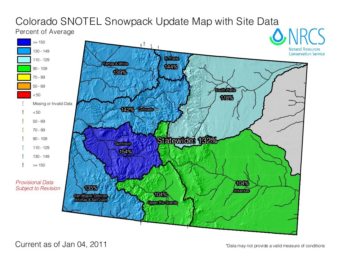
The moisture-laden pineapple connection that brought mid-month snows zeroed in on the central part of the state, where the Gunnison Basin snowpack is now at 155 percent of average. Even the Upper Rio Grande Basin, in south-central Colorado, is now at a 106 percent of normal after lagging near 60 percent for much of the autumn. The San Miguel, Dolores, Animas and San Juan Basin, in the Four Corners area, is up to 136 percent of average and the Colorado Basin is at 143 percent.
From The Greeley Tribune (Bill Jackson):
Reservoir storage is at or slightly above normal across most of the state and combined with the good start to the snowpack, that provides optimism for the state’s water providers. Statewide, the snowpack is 36 percent above the long-term average. For the South Platte River basin, it is
2618 percent above average and for the Colorado River, it is nearly5042 percent above average. [ed. note: Things can change quickly in Colorado. Click on the thumbnail graphic above and to the right for today’s snowpack update map from the NRCS.]“This is a welcome start to the year for Colorado’s water users, and we’re hoping these conditions remain with us for the next few months,” Allen Green said in a news release. He is the state conservationist with the NRCS in Denver…
In southern Colorado, the snowpack was 57 percent of average on Dec. 16. But the weather pattern shifted, and those averages increased to 140 percent of average by Dec. 31. At one automated site on Coal Bank Pass north of Durango, storms delivered 78 inches of snow which resulted in an additional 6.7 inches of water.