2011 Colorado legislation: HB 11-1150 would transfer wildlife fees to the Colorado Water Conservation Board construction fund

A picture named dnrpipelineconcepts309

From The Denver Post (Karl Licis):

[House Bill 11-1150, Concerning Additional Revenues for Water Storage Projects], sponsored by Rep. Jon Becker, with Rep. Jerry Sonnenberg as co-sponsor. The bill, assigned to the House Agriculture, Livestock and Natural Resources Committee, proposes to transfer $5 million per year for the next 10 years from the wildlife cash fund to the Colorado Water Conservation Board’s construction fund, to be used for water-storage projects. Such a project ostensibly would have to enhance, create or preserve wildlife habitat, and the CWCB would need to determine that doing so would not violate federal law…

Recent appropriations of the wildlife cash fund have been about $85 million a year. The potential annual loss of $5 million represents about a 6 percent decrease in funding for the DOW, but that could merely be the proverbial tip of the iceberg. The DOW also receives about $20 million a year in federal excise-tax returns through the Pittman-Robertson and Dingell-Johnson acts. That money has specific guidelines for how it can be spent. The U.S Fish & Wildlife Service already has indicated to the legislature that HB 1150 would be an inappropriate expenditure of such money. Consequently, if the bill became law, the DOW stands to lose some $25 million a year, or $250 million over the 10-year life of the bill. Such an impact no doubt would be devastating to the DOW’s efforts in serving license-buying hunters and fishermen and all others who value the state’s wildlife resources.

With a loss of federal dollars likely, HB 1150 could be dead on arrival. Even so, with those “goose eggs” in the nest, it’s a reminder to be ever vigilant.

From email from Colorado Trout Unlimited:

Urgent! Please take action now! Call your State Senators and Representatives today at 1-800-811-7647 and urge them to stop the $260 million raid on your fish and wildlife license dollars!

Recently introduced by Reps. Becker, Sonnenberg, and Sen. Jahn, HB 1150 would gut funding for the Colorado Division of Wildlife and is this year’s most serious attack on Colorado’s fish and wildlife – and the state’s hunters and anglers.

HB 1150 will take your hunting and fishing license dollars away from the intended purpose – fish and wildlife management and conservation. INSTEAD, these fund will be transferred from your pocket and the Colorado Division of Wildlife to the Colorado Water Conservation Board to develop water storage projects.

If passed, HB 1150 will result in a $260 million net loss of funding for fish and wildlife conservation and management in Colorado over the next ten years – $50 million in funds directly transferred, and $210 million in lost federal matching grants.

Please call your State Representative today and urge them to vote NO on HB 1150. You can reach the Capitol by calling: 1-800-811-7647. If you don’t know who your State Representative is or how to reach them, you can look them up and find their contact information by clicking here and entering your zip code…

Interested in speaking out at the Capitol? HB 1150 is scheduled for hearing in the House Agriculture Committee on Monday, February 21 . This is an opportunity for the public to voice their concerns. Please contact Erica Stock estock@tu.org if you would like to attend.

More 2011 Colorado legislation coverage here.

Lower Arkansas Valley: The Caitlin and Fort Lyon canals file applications to add shares to the Colorado Water Protective and Development Association augmentation plans

A picture named arkbasinditchsystem.jpg

From The Pueblo Chieftain (Chris Woodka):

Applications by a group of shareholders on the Fort Lyon Canal and by the Catlin Canal Co. were made in January to allow use of water for augmentation plans by the Colorado Water Protective and Development Association. Formed in 1965, CWPDA provides augmentation for about 600 members and 1,336 wells in the Arkansas Valley. It serves municipal, industrial and agricultural users. Under 1996 well rules adopted for the Arkansas Valley, groups that provide augmentation are allowed to use plans administered by the state engineer’s office for up to 10 years. Augmentation supplies provide replacement water for depletions caused by wells that were put into operation after the 1948 Arkansas River Compact…

“CWPDA really didn’t get into the business of using water rights they own as a source of augmentation until later,” said Steve Witte, Division 2 engineer. “After the drought in 2002, more operators began bringing in their own shares.”[…]

Under an appendix to the Kansas v. Colorado case, state engineers from both states agreed to require Colorado water rights owners to file for a change of use, when needed, after the third year a supply was used under an administrative water plan. Part of that decision also was driven by the 2003 Empire Lodge state Supreme Court decision, which curtailed some of the authority previously assumed by the state engineer. This year, Witte notified the CWPDA that change of use applications for water rights used in 2011 augmentation plans had to be filed by Jan. 31, prompting the filings from the Fort Lyon and Catlin canals.

More Arkansas River basin coverage here.

A look at the economics of Colorado’s agricultural sector

A picture named nellieslastharvest10262010

Here’s an in-depth look at the 2010 Statewide Water Supply Update forecasts and the possible effects on Colorado’s agricultural sector, from Chris Woodka writing for The Pueblo Chieftain. Click through and read the whole article. Here’s an excerpt:

Two top-ranking state officials brought that message home last week. Continuing to dry up agriculture could amount to a hit of more than $1 billion to the state’s economy. John Stulp, who is advising Gov. John Hickenlooper on water issues, made a case for leaving water in the areas where it has historically been used. “You can use and reuse water, but once you ship it out, it’s gone,” Stulp said. “If we double our population in 40 years, think of how long you’ll be sitting in traffic on Interstate 25.”

Stulp’s replacement as Colorado Agriculture Commissioner, John Salazar, called for more attention to the impact of costs to rural communities if land is dried up. “Agriculture is the second-largest contributor to the state economy,” Salazar said. “The next 10 years are supposed to be good for agriculture, but the only way for us as a state to benefit is to have the water available to produce crops.”[…]

State agricultural revenues in 2007 were $6 billion, according to the Census of Agriculture, and irrigated acres were far more productive than dryland acres.

Worst-case scenarios:

– In the Arkansas River basin, the five counties with the largest production from irrigated acreage generated ag revenues of $616.9 million. If 17 percent of the farm land were dried up, that could amount to more than $100 million from farm income alone.
– In the South Platte basin, where there are nine of the 10 largest ag production counties, up to one-third of irrigated farm land could be dried up. That would mean a drop of about $1.25 billion in an annual $4 billion farm economy.
– In the Rio Grande basin, ag revenues totalled $320 million, and a 14 percent drop would mean a loss of $58 million.
– The losses statewide from continued dry-up could be close to $1.5 billion, just in the value of products sold. That would not take into account the impacts on communities…

The actual value of crops grown in the state was examined in a 2005 study by Colorado State University. Values ranged from $350 to $1,100 per acre. The study found the highest per-acre values in the San Luis Valley and the lowest in the Arkansas River basin. When results of the study were published, many farmers in the Arkansas Valley told The Chieftain the numbers were too low. “We haven’t updated the land value study, but have been working on analysis for the changes to the ag sector if lands are retired,” said James Pritchett, professor of economics, who led the 2005 study. “We’ve also been doing work on limited-irrigation economics.”[…]

Colorado residents need to be better educated on where their food comes from, Salazar said. “A lot of folks think our food comes from a grocery store,” Salazar said. “Once people understand, they’ll see the relationship to agricultural businesses in the rural communities.”

Two years on WordPress

A picture named johnnellcoyotegulch.jpg

Two years ago I created Coyote Gulch here on WordPress.com. I was having software troubles with the old weblog.

This is post 4,193 since 2009. Thanks for reading and thanks for the kind words when I’m lucky enough to meet you in person.

Fountain Creek: The City of Pueblo is asking Pueblo County to throw some dough at a sedimentation mitigation test

A picture named sedimentcollector.jpg

From The Pueblo Chieftain (Chris Woodka):

The $350,000 request is part of a $1 million project that includes a test of a 30-foot collector near the confluence with the Arkansas River to remove sediment from flowing water in Fountain Creek in order to preserve the ability of the levee system to protect homes and businesses from flooding.

The larger project also includes a detention pond in north Pueblo that is designed to reduce the peak flow of moderate floods. City, state and federal funds are being used to finance the effort. On Thursday, Pueblo stormwater consultant Dennis Maroney presented commissioners with a list of projects that could qualify for funding under a $2.2 million settlement reached by the county with Colorado Springs Utilities last year. The money fulfilled the commitment by Colorado Springs to pay for dredging Fountain Creek through Pueblo under the 1041 permit for the Southern Delivery System. The sediment collection system is the most immediate need. Maroney requested about $350,000 to cover costs to complete site preparation, install the collector and haul sediment to nearby land the city owns on Joplin Avenue.

More Fountain Creek coverage here and here.

Whitewater rafting business news

A picture named cachelapoudreriver.jpg

From the Fort Collins Coloradoan (Pat Ferrier):

Guides brought nearly 37,400 people down the glistening waters of the Poudre River – about 400 more than the year before when the economic downturn hit the industry, according to a new report issued by the Colorado River Outfitters Association. The Poudre River was the sixth busiest of the 27 Colorado rivers with commercial activity…

With mountain snowpack at about 130 percent of average, [Brad Modesitt, owner of Mountain Whitewater Descents] already is getting bookings for summer trips. “We will have some water and we’ll have some fun out there.”[…]

Well-educated and affluent, customers of the five local rafting companies permitted to take visitors down the river spent $4.3 million on rafting, food, lodging, souvenirs in the area. That translates into an $11 million economic boon for the city and its surrounding area, according to the Colorado Tourism Board. The economic impact is up slightly from $4.2 million in direct expenditures and $10.8 million overall in the 2009 survey. Statewide, the 2010 economic impact totaled more than $150 million from more than a half-million rafters…

The Arkansas River was the busiest with 211,150 commercial user days, according to the Colorado River Outfitters Association.

More whitewater coverage here.

New Glenwood Springs wastewater treatment plant update

A picture named wastewaterliftstation.jpg

From the Glenwood Springs Post Independent (John Stroud):

During a brief project update at last week’s Glenwood Springs City Council meeting, [project engineer Chad Paulson of SGM Engineers] said about one-third of the work is complete and approximately 42 percent of the budget spent…

The new plant, located west of the existing municipal operations building, will replace the outdated sewer treatment facility on Seventh Street, near the confluence of the Roaring Fork and Colorado rivers. The construction contract was awarded last spring to Salida-based Moltz Construction for $22.3 million…

Including engineering and the related work last summer to connect the lift station at the current wastewater treatment plant site to the new location, the total project cost is around $33 million. Some of that overall cost will also cover eventual demolition of the old plant.

More wastewater coverage here and here.

Pagosa Springs scores $4 million from USDA for new wastewater treatment plant

A picture named wastewatertreatmentprocess.jpg

From the Pagosa Sun (Jim McQuiggin):

Yesterday, the town of Pagosa Springs received notice from the USDA that it would be receiving the funds for the construction of the facility. The money includes $3,145,000 in loans (at 2 percent interest) and $787,000 in grants. Along with other funds secured two years ago (a $2 million loan from the Colorado Water Resources and Power Development Authority and a $1.25 million grant from the Department of Local Affairs), the town of Pagosa Springs has just over $7 million to construct the plant. “I’m relieved that we’re finally moving forward,” said Phil Starks, supervisor for the Pagosa Springs Sanitation General Improvement District. According to Starks, the town would most likely break ground on the project in May.

More wastewater coverage here and here.

Energy policy — nuclear: The EPA to revise Powertech USA’s permit for a test well

A picture named uraniuminsituleaching.jpg

Here’s the release from the Environmental Protection Agency (Richard Mylott):

The U.S. Environmental Protection Agency (EPA) will revise and reissue a permit authorizing Powertech, USA, to re-inject water as part of an aquifer pump test at the proposed Centennial uranium recovery site in Weld County, Colo. The new draft Underground Injection Control (UIC) Class V permit will include a specific water pressure requirement for reinjection that was inadvertently not included in a permit EPA issued last December.

“EPA will remedy this oversight and clarify this permit with full transparency and public involvement,” said Steve Tuber, EPA’s assistant regional administrator in Denver. “We will issue a new draft permit that maintains specific and rigorous requirements to ensure the protection of groundwater.”

EPA issued a final Class V UIC permit to Powertech in December 2010 following a year-long public review and comment process. Since that time, EPA’s Environmental Appeals Board (EAB), an independent board that oversees EPA permitting actions, has received two petitions for review of the final permit. The EAB has asked EPA to file a response addressing the petitioners’ contentions.

After reviewing the petitions, EPA has decided to withdraw, revise and reissue the permit. This decision is based on a petitioner’s issue noting that the final permit did not specify that Powertech is required to not exceed zero pressure at the wellhead when re-injecting water from the pump test. While EPA has clearly stated its intent to require this condition, and Powertech has agreed to comply, this requirement was inadvertently not included in the final permit. The maintenance of zero pressure at the wellhead is important as it helps ensure that the re-injection activity will not cause movement of water between aquifers beyond that which is naturally occurring.

EPA intends to issue a new draft permit within the next several weeks that specifically requires that Powertech not exceed a Maximum Allowable Injection Pressure (MAIP) of zero at the wellhead. EPA will also clarify language in the permit to address additional concerns noted in the petitions. Upon issuing the new draft permit, EPA will initiate a public review and comment period.

This UIC Class V permit is limited to groundwater re-injection. Specifically, the permit will enable Powertech to re-inject water taken from a sandstone aquifer within the Fox Hills formation during an aquifer pump test in which groundwater will be placed in holding tanks and re-injected, unaltered, into the same aquifer. The test is designed to provide information about hydrogeology at the Centennial site and inform the feasibility of any future in-situ uranium extraction activities. Conditions of the aquifer pump test itself are subject to prior approval by the Colorado Division of Reclamation, Mining, and Safety.

This UIC permit does not allow for the removal or processing of uranium or the disposal of waste water at the project site. Such activities would be subject to additional EPA and State permit(s). Any future UIC permit applications will be subject to an extensive public review process, including access to technical information, public meetings and comment periods consistent with applicable laws and regulations.

The State of Colorado is an Agreement State under the Nuclear Regulatory Commission’s regulations for uranium in-situ leaching facilities and has authority for the licensing and operation of uranium extraction activities.

Related documents can be found at: http://www.epa.gov/region8/water/uic/

More coverage from The Denver Post (Joey Bunch). From the article:

…in taking that action, the Environmental Protection Agency’s Region 8 office in Denver said it intends to draft another permit within the next few weeks and open it up for public comment, according to paperwork filed with the Environmental Appeals Board in Washington.

The environmental group Coloradoans Against Resource Destruction, or CARD, and James Woodward, who lives near the proposed site near Nunn, had filed an appeal with the board in January, which temporarily stayed the permit. Their concerns included the EPA’s failure to review Power tech data from aquifer-pump tests in 2008 in the same geologic formation — one just 500 feet from the currently proposed injection well. They also claimed that the EPA failed to include a maximum well-injection-pressure requirement in the permit and that the agency did not evaluate the success in plugging other such sites. “The petitions raised substantial issues with the permit, warranting re-evaluation by EPA, and they were right to withdraw (the permit),” CARD co-founder Jay Davis said in a statement.

More coverage from the Colorado Independent (David O. Williams):

“Powertech wants to clarify that this really is not a revocation of a permit, which has a negative connotation, but simply a withdrawal of a permit that the EPA wants to go back and reconsider, and Powertech believes that the next issued approval will be even more airtight than this one was,” John Fognani, of Fognani and Fought, told The Colorado Independent…

The Powertech project is part of a growing effort to revive Colorado’s moribund uranium mining industry in order to capitalize on a push for more nuclear power in the United States as a much lower carbon alternative to coal- and gas-fired power plants. However, some environmental groups in Colorado are resistant to what they consider the “dirty front end” of uranium mining.

Fognani says technology has improved dramatically since the heyday of the state’s uranium mining boom in the 1950s and 60s and that nuclear power, fueled by Colorado uranium, needs to be a bigger part of the nation’s energy mix. The latest EPA decision, he said, is an example of the federal government making sure its permitting process is “airtight.”

“The fundamental feeling is that the EPA decision to grant the permit in the first instance was imminently defensible, but this is an EPA decision and the company will respect and abide by it and is comfortable with it,” Fognani said.

More coverage from the Fort Collins Coloradoan (Bobby Magill):

The permit would have allowed Powertech to take 43,000 gallons of water from an underground aquifer and re-inject it as part of a test of its uranium mining technique. No uranium would be mined in the test.

On Monday, the EPA announced it left out some details in Powertech’s permit, requiring the agency to withdraw the permit, revise it and then reissue it sometime in the next few weeks. “EPA will remedy this oversight and clarify this permit with full transparency and public in-volvement,” EPA Assistant Regional Administrator Steve Tuber said in a statement. “We will issue a new draft permit that maintains specific and rigorous requirements to ensure the protection of the groundwater.” The EPA received two petitions from the Western Mining Action Project and James B. Woodward of Wellington after the permit was issued asking the agency to review the permit, EPA spokesman Richard Mylott said.

The EPA intended to make Powertech adhere to a water pressure requirement during the test, but the EPA accidentally left the requirement out of the permit, Tuber’s statement said. The agency plans to require zero pressure at the injection well to prevent water from moving between aquifers during the test.

More nuclear coverage here and here.

Arkansas Basin Roundtable meeting recap

A picture named arkansasbasinalluvialaquifersubregions.jpg

From The Pueblo Chieftain (Chris Woodka):

“There seems to be the attitude that we’re getting over the hump,” said John Stulp, the new head of the IBCC and Gov. John Hickenlooper’s point man for water issues. “We’re starting to talk about solutions.” Stulp made his first visit to the roundtable, and urged members to attend a summit of all nine basin roundtables March 3 in Denver

The IBCC has gone from being a roomful of people who were wary and distrustful to a group seeking common ground, Stulp said during brief remarks to the Arkansas Basin Roundtable. “They’ve gotten out of the attitude of going to your corner and come out fighting,” said Stulp, a dryland wheat farmer from Lamar who just ended a term as Colorado’s agriculture commissioner. “They still have their corners, but there’s not as much fighting.”[…]

Roundtable members spent the last month doing their homework by reading the report, then were asked to evaluate it in an electronic poll at the meeting. Three-fourths of the roundtable members said the report was good or very good, but that it needed changes. Most felt the most neglected area was finding a new supply, and the group spent most of the afternoon talking about that issue. The group liked balancing the needs of all basins involved in water transfers, having multiple benefits in water projects and protecting agriculture and the environment. Some felt the report didn’t go far enough in addressing the real problems, however…

Dan Henrichs, superintendent of the High Line Canal, said more storage and ways to divert water are needed. “You can have all the alternative methods you want, but what we lack is the infrastructure to move the water from Point A to Point B,” Henrichs said.

SeEtta Moss, of the Arkansas Valley Audubon Society, pointed out that all nonconsumptive uses should not be given the same weight as mitigation for water project impacts. “Water in a reservoir for boating is not a substitute for water in a mountain stream for trout,” Moss said.

More IBCC — basin roundtables coverage here.

Energy policy — oil and gas: Group files lawsuit over exploration in Park County

A picture named derrick.jpg

From the Associated Press via Bloomberg Business Week:

Two of the parcels in Park County are next to Antero Reservoir, which is owned by Denver Water. The county already has some wells within its boundaries.

The group Be the Change said in a letter Monday to the land board’s acting director that there should be a moratorium on leases in the area until more is known about how drinking water might be affected by hydraulic fracturing, a technique for extracting oil and natural gas.

“This is a runaway train and no one is manning the throttle,” group member Phillip Doe said Thursday.

Board commissioners have a meeting Friday when it could hear public comments, including the request from Be the Change…

A spokeswoman for Denver Water said the utility hasn’t taken a position on the auction. Doe said he’d like to propose having Denver Water pay to keep the mineral rights around Antero Reservoir undeveloped.

More oil and gas coverage here and here.

Rio Grande Basin Roundtable meeting recap

A picture named riograndebasin.jpg

From the Valley Courier (Ruth Heide):

Members of the Rio Grande Roundtable, a group representing the Rio Grande Basin (Valley) in part of a larger statewide effort, talked about future water challenges during their meeting this week in Alamosa.

“Really this whole effort is about trying to solve the statewide issues,” said Roundtable member Travis Smith, who represents the basin on statewide water groups such as the Interbasin Compact Committee (IBCC), comprised of two members from each of the basin roundtables.

“If we do nothing … we will see another 500,000 acres in the next 30 years leave agriculture and go for taps in Aurora,” Smith said. “What does it mean for us as a Valley? Some of these issues are not knocking on our front door, but they are close.”

Smith reminded the group that the roundtables have existed for more than five years now, and the Valley’s roundtable has successfully acquired funding during that time for several important local water projects such as ditch and stream bank repair.

Smith added that last year Governor Bill Ritter asked the IBCC for a report before he left office, so the IBCC compiled a report that outlined some possible water solutions/sources to meet the state’s future needs.

Smith said four areas were suggested: transfers of water from agriculture to municipal and industrial needs, the currently popular method of acquiring water to meet Front Range development; conservation measures; new water supplies, a very controversial water source since “there is no new water in Colorado, in my mind; it’s just a redistribution of water,” Smith said; and “identified projects and processes,” or implementing projects that could help meet future Colorado water demands.

More IBCC — basin roundtables coverage here.

2011 Colorado legislation: The State Engineer’s office decides against backing bill that was designed to allow the State Engineer to approve groundwater sub-district management plans as substitute water supply plans in the San Luis Valley

A picture named smithreservoir.jpg

From The Pueblo Chieftain (Matt Hildner):

The measure, which was never introduced at the Capitol, would have allowed groundwater users to apply for a substitute water supply plan, thereby avoiding shutdowns while they await court approval of groundwater subdistricts. A statement issued by the engineer’s office said moving forward with the measure would create undue controversy and possibly result in amendments that hindered the proposal and complicated rule-making efforts for Rio Grande basin well users…

…letting go of the temporary plans could leave some of the valley’s 6,000 groundwater wells vulnerable to being shut down. Wolfe has said the engineer’s new rules, which would require shutting down wells that do not have replacement water, are expected to be in place by 2012. The subdistricts would tax its members to help buy replacement water to make the senior surface users whole, but the first subdistrict remains under review by the Colorado Supreme Court. Other potential subdistricts are awaiting that ruling before they attempt to gain approval from the valley’s local water court. The engineer’s office hopes the issue can be resolved by an advisory committee Wolfe selected two years ago to assist in drafting groundwater rules in regulations

More San Luis Valley groundwater coverage here and here.

Ditch and Reservoir Company Alliance 9th annual convention February 16-18

A picture named bessermerditch.jpg

From email from DARCA (John McKenzie):

Resource Allocation to Enhance Survival

Who: Ditch and Reservoir Company Alliance (DARCA)
What: An In-Depth look at Economics and the study of Resource Allocation
Where: Embassy Suites Hotel in Loveland, Colorado
When: February 16-18, 2011

The Ditch and Reservoir Company Alliance (DARCA), is a nonprofit organization dedicated to serving the needs of mutual ditch and reservoir companies, irrigation districts and lateral companies. This year, DARCA will be holding their Ninth Annual Convention at the Embassy Suites Hotel in Loveland, Colorado.

The Convention, Resources Allocation to Enhance Survival will be held February 16-18th and will focus on economics and resource allocation. This will be a three-day conference with a wide variety of speakers to discuss: water and the Colorado economy; tax and accounting issues; what assets ditch companies own, and the best ways to utilize such assets; on-farm irrigation optimization; and managing the lateral ditch company.

Speakers will include ditch company members, farmers, researchers, economists, and government officials. The Keynote Speaker, John Stulp, is a Special Policy Advisory to the Governor, and Director of the Interbasin Compact Committee (IBCC). Heather L. Bailey, a State and National Register Historian will be present to discuss issues and concerns with Historical Ditches and the National Register of Historic Places. Day one of the convention, Thursday February 17th, will focus on Laying the Groundwork. Registration and Breakfast will start at 8 a.m. and the day will end with drinks and hors d’oeuvres at 5:30 p.m. The second day of the convention will be Friday, February 18th and will focus on DARCA Business beginning at 8 a.m. and ending at 12 p.m.

The Pre-Convention Workshop, Low Head Hydroelectric Opportunities, will be held Wednesday, February 16th from 9 a.m. until 4 p.m. at the Northern Colorado Water Conservancy District in Berthoud, Colorado. This workshop will explore the possibilities to generate hydroelectric power from irrigation ditches, and discuss emerging technological advances that will help enhance this method of renewable energy.

For full schedule of events and more information regarding convention registration as well as sponsorship or exhibitor opportunities please visit http://www.darca.org or contact John McKenzie at (970) 412-1960 or john.mckenzie@darca.org.

NIDIS Weekly Climate, Water and Drought Assessment Summary of the Upper Colorado River Basin

A picture named cowyprecip013102062011nidis.jpg

Here are the notes for this week from the Colorado Climate Center. Here’s and excerpt:

The northern and central mountains of Colorado received near to above average precipitation, but the San Juan and Sangre de Cristo mountains received below to near average precipitation, ranging from 51 – 110 percent of normal. The northern plains of Colorado received beneficial moisture that ranged from 90 – 200 percent of normal and the southern plains in the Arkansas basin ranged from 71- 130 percent of normal.

Pueblo: Arkansas River levee repairs update

A picture named leveetypesusace.jpg

From The Pueblo Chieftain (Chris Woodka):

Construction crews started work late last week on moving the river away from the levee in order to place drains at the base of the levee. The drains are needed because when the fish ladder and kayak course were built, river flows changed and water began undercutting the dirt at the base of the concrete wall on the north side of the river. “They’ve been working down in the river since Thursday,” said Gus Sandstrom, president of the Pueblo Conservancy District, which is working with the U.S. Army Corps of Engineers to repair the levee. “They will be using concrete barriers and rock to divert the river. They are also building a construction bridge that will allow trucks to cross the river.” Work started Thursday, was interrupted by snow Friday, continued through the weekend and hit another snag Tuesday as cold, windy, snowy weather came and went.

More Arkansas River basin coverage here.

Energy policy — nuclear: The Sheep Mountain Alliance files lawsuit over the licensing procedure for the proposed Piñon Ridge uranium/vanadium mill

A picture named pinonridgesite.jpg

From the Colorado Independent (David O. Williams):

In a legal challenge filed in Denver District Court last week, the Sheep Mountain Alliance alleges the Colorado Department of Public Health and Environment (CDPHE) violated both the federal Atomic Energy Act and the Colorado Radiation Control Act when it issued a license for Toronto-based Energy Fuels to build the first new uranium processing mill in the United States in more than three decades…

The Sheep Mountain Alliance lawsuit alleges the state didn’t allow the public to ask regulators or Energy Fuels’ officials direct technical questions about the mill, which violates the Atomic Energy Act. “Sheep Mountain Alliance exhausted all remedies before we decided to file this lawsuit,” Linda Miller, a member of Sheep Mountain Alliance board of directors, said in a release. “We participated in the approval process but our concerns were not addressed. We’re disappointed that the state did not issue a decision that would have protected the public interest and we must now rely on the district court to uphold the law.”[…]

The lawsuit accuses the CDPHE of violating state laws designed to keep Colorado taxpayers from having to shoulder the costs of cleaning up uranium mills, which the suit claims have contaminated groundwater everywhere they’ve been built in the state.

More coverage from The Los Angeles Times (Nicholas Riccardi). From the article:

State regulators said they followed all appropriate procedures when they approved the permit, but the lawsuit, filed Feb. 4 in state court by the Telluride-based Sheep Mountain Alliance, alleges that is not the case. It claims the state did not hold adequate public hearings and that the licensing violates a state law prohibiting uranium mills near areas that already have high levels of heavy metals in their water. The suit also contends that the state did not require the mill’s owner to set aside enough money for mitigation, noting that prior groundwater contamination in Colorado mills has cost up to $500 million to clean up. Energy Fuels is only required to set aside $11 million, according to the complaint.

More Piñon Ridge coverage here. More nuclear coverage here and here.

Energy policy — oil and gas: Silt Mesa family’s water well not impacted by production and exploration in the area according to the Colorado Oil and Gas Conservation Commission

A picture named marcellushydraulicfracturing.jpg

From the Glenwood Springs Post Independent (John Colson):

Dave Neslin, director of the COGCC, said the test on the Strudleys’ well was one of approximately 25 conducted on wells in the Silt Mesa area, where Antero Resources began drilling wells for natural gas last summer. The results of tests conducted on most of those wells have not come back yet, Neslin told the Post Independent. The Strudley well test results were reported in a Dec. 22, 2010, letter from COGCC Environmental Protection Specialist Linda Spry O’Rourke, who has an office in Rifle, to the Strudley family. The tests indicated that “there is no data that would indicate the water quality in your domestic well has been impacted by nearby oil and natural gas drilling and operations,” the letter stated. The 11-page letter was accompanied by nearly 250 pages of scientific data.

Beth Strudley said she doubts the report is correct and said she hired a private firm to conduct another test. “I certainly wouldn’t trust anything the COGCC does as far as I could throw them,” she declared, voicing a belief held by some that the COGCC is too closely tied to the oil and gas industry to be counted on to run unbiased tests.

More oil and gas coverage here and here.

USGS: Glen Canyon Dam High-Flow Experiments Provide Insights for Future Flow Management of the Colorado River

A picture named glencanyondam030508

Here’s the release from the United States Geological Survey (Lara Schmit/Joan Moody):

High-volume water releases from Glen Canyon Dam can increase sandbar area and volume, but may also result in large increases in non-native rainbow trout downstream of the dam, according to a new U.S. Geological Survey report released today.

The report, Effects of Three-High Flow Experiments on the Colorado River Ecosystem Downstream from Glen Canyon Dam, Arizona, documents the effects of high-flow experiments (HFEs) on resources in Glen Canyon National Recreation Area and the Grand Canyon National Park. The U.S. Department of the Interior conducted HFEs at Glen Canyon Dam in March 1996, November 2004 and March 2008.

“This important scientific research has paved the way for better management of Glen Canyon Dam to enhance protection of downstream resources,” said Anne Castle, Assistant Secretary for Water and Science in the Department of the Interior. “The report pulls together the results from three different high-flow releases so that such events in the future can be targeted for optimal resource benefits and minimizing adverse effects.”
Grand Canyon sandbars provide habitat for wildlife, serve as camping beaches for recreationists, and supply sand that may preserve vegetation and help protect archaeological sites. High flows also create areas of low-velocity flow, or backwaters, used by young native fishes, including endangered humpback chub.

“Research and long-term monitoring of the effects of three high-flow experiments have allowed scientists to unravel some of the many uncertainties about how these Glen Canyon Dam releases affect downstream river resources,” said Dr. Ted Melis, deputy chief of the USGS Grand Canyon Monitoring and Research Center and the report’s editor. “We believe that the scientific findings presented in the report will allow managers to better plan future flow operations to meet desired resource goals.”

HFEs, also known as artificial or controlled floods, are effective at increasing both sandbar area and volume when they are conducted soon after “new” sand has been supplied to the system by flooding from tributaries downstream of the dam. In the absence of new sand supplies, as was the case in 1996, HFEs may still build sandbars, but only by eroding the lower portions of existing sandbars. In other words, sandbars became higher and not wider in 1996.

According to the report, the best possibility for rebuilding and maintaining sandbars is to time HFEs to follow the seasonal flooding of tributaries downstream of the dam. During years of below-average upper Colorado River Basin precipitation, allowing multiple new sand inputs to accumulate before conducting an HFE would result in the greatest sandbar building, the report said. However, during years of wetter upper basin hydrology, HFEs might be more effective immediately following or even during tributary flooding.

Sandbars are built relatively quickly (hours to a few days) when new sand is available from tributaries, as occurred in 2004 and 2008, but they also tend to erode within days to several months under normal dam operations following an HFE. Despite this ongoing erosion, long-term monitoring indicates that about 75 percent of sandbars measured in Marble and Grand Canyons were larger in October 2008 than in February 1996, before the first HFE was conducted.

The 2008 HFE was followed by large increases in non-native rainbow trout in the Lees Ferry reach, the sport fishery immediately downstream of the dam. These fish moved downstream and into areas that support native fishes, including the area with the largest population of endangered humpback chub.

The eight-fold increase of rainbow trout that occurred in 2008 is of particular note, the report said, because rainbow trout are known predators of young humpback chub and may also compete with native fish for limited food resources. Overall, the studies found that HFEs have had no measurable positive effects on juvenile or adult humpback chub populations.

The report is a product of the Glen Canyon Dam Adaptive Management Program, a federally authorized initiative to ensure the mandate of the Grand Canyon Protection Act of 1992 is met through advances in information and resource management. The USGS Grand Canyon Monitoring and Research Center has responsibility for scientific monitoring and research efforts for the program. The Bureau of Reclamation provides financial support for the program that is derived from hydropower revenues from Glen Canyon Dam operations.

The Bureau of Reclamation recently released for public comment two draft Environmental Assessments (EAs) related to topics addressed by this report (1) Development and Implementation of a protocol for High-Flow Experimental Releases from Glen Canyon Dam, Ariz., 2011 through 2020 and (2) Nonnative Fish Control Downstream from Glen Canyon Dam.

More coverage from New West (David Frey):

“There’s really no way we can expect to have a pre-dam landscape by implementing high flows,” said Paul Grams, a hydrologist with the Grand Canyon Monitoring and Research Center and a co-author of a report released Tuesday that examined the findings of three experiments of high flows from the Glen Canyon Dam stretching back to 1996.

Since Glen Canyon Dam was completed in 1963, it not only trapped the water that used to flow through the canyon lands. It also trapped the sediment that made its way to the Grand Canyon. More than just dirt, this mix of sand, gravel and clays played a key role in forming ecosystems for native plants and animals. The dam also took away the river’s historic ebbs and flows from floods to trickles. These changes in water volume, which helped shape the river, were replaced with a steady flow throughout the year. Changes in temperature, flow and sand contributed to losses of native fish, invasions of nonnative species, the erosion of sandbars and the narrowing of river rapids. In an effort to re-create natural flooding, researchers experimented with high-flow releases from the dam in 1996, 2004 and 2008. They found artificial floods increase the size and number of sandbars downstream, but it’s unclear how long the sandbars can survive under ordinary dam operations.

Scientists found the sandbars are most successful when the releases take place during times of normal flooding, when more sand is flowing from tributaries downstream from the lake. The high flows seem to help native fish, researchers found, but they may also encourage nonnative rainbow trout. That’s good news upstream, where rainbow trout are encouraged for fishermen, but it’s bad news downstream, where the trout can muscle out native species, like the endangered humpback chub. “Sandbars are important,” Grams said. “They’re a resource for river recreationists, a resource for riparian vegetation, riparian ecosystems. The underwater part of sandbars creates habitat for native fish.”

More Colorado River basin coverage here.

CWCB: Next Water Availability Task Force meeting February 16

A picture named usdroughtmonitor02012011

From email from the Colorado Water Conservation Board (Ben Wade):

The next Water Availability Task Force (WATF) is scheduled for Wednesday, February 16, 2011 from 9:00-11am at the Colorado Division of Wildlife, 6060 Broadway, Denver, CO, in the Bighorn Room. A reminder email with the agenda will be sent prior to the meeting.

More CWCB coverage here.

Snowpack news

A picture named snowpackcolorado02082011

From The Pueblo Chieftain (Chris Woodka):

Statewide, the snowpack reached 123 percent of average as the most recent round of storms moved through. That’s a slight improvement from the end of January, a dry month that saw a drop in snowpack. The Arkansas River basin climbed above average in snowpack, although the Lower Ark Valley is entering its third month of severe drought, according to the U.S. Drought Monitor. Meanwhile, the Rio Grande basin remains the driest area of the state, with snowpack at 87 percent. Snow levels increase toward the northern part of the state, with most ski areas reporting 5-8 feet of snow — some are boasting 24 inches of new snow in 72 hours. Some Snotel sites showed levels of well over 100 inches in the northern mountains. In the Roaring Fork basin, which provides supplemental water imports for the Arkansas River, snow levels are at 133 percent of average…

Snowpack in the Upper Arkansas basin is at about 70-90 percent of peak levels (the depth typically reached in mid-April), while it remains at 40-70 percent in the southern mountains, said Pat Edelmann of the Pueblo office of the U.S. Geological Survey.

More coverage from The Pueblo Chieftain:

Snowfall hit the San Juan Mountains hard. Wolf Creek Ski Area reported 23 inches of snow from the storm. In the Sangre de Cristo foothills, spotters for the National Weather Service reported over 10 inches near Crestone and 8.5 inches southeast of Fort Garland.

More coverage from The Colorado Springs Gazette (Matt Steiner):

Through this week, Colorado Springs had received 0.26 inches of precipitation, barely a third of the 0.77 inches it normally gets by early February, said Kyle Mozley, a meteorologist with the National Weather Service in Pueblo…

Usually, it takes 10 inches of snowfall to equal an inch of precipitation, but not when the temperature is below zero like it was last week and in the single digits like Tuesday. “When you get these cold temperatures like we’ve seen, it takes 20 to 30 inches of snow to get one inch of precipitation,” Mozley said…

The snowpack is above average after a series of blizzards on the Western Slope and the snowiest months — March and April — are still ahead. “There’s no reason to be concerned,” Mozley said.

The Natural Resources Conservation Service reports about 120 to 130 percent of normal snowpack in the mountains, which has kept reservoirs almost full. “We’ve had really, really good reservoir levels,” said Patrice Quintero, a Colorado Springs Utilities spokeswoman. “It’s looking like it normally does for this time of year.”

Colorado Foundation for Water Education: Climate Workshop — Ice Lab Tour

A picture named drillingicecoreinantarctica.jpg

From email from the CFWE (Aaron Parker):

On March 11, 2011, the Colorado Foundation for Water Education is hosting the ‘Climate & Colorado’s Water Future’ Workshop; a fun, interactive workshop on climate science in Lakewood, CO where participants will bundle up for an exclusive tour of the National Ice Core Laboratory.

Educators learn to prepare students to think strategically about climate science and receive several hands-on curriculum tools. Secondary teachers can also receive 1/2 continuing education credit from the Colorado School of Mines. Nolan Doesken, State Climatologist, will give a lively talk on how climate may impact Colorado’s water future. We will also learn how climate data is taken from ice cores extracted in polar regions from former NICL Director, Todd Hinkley.

Workshop Fee: $50.00 (includes lunch, books and tour)

View more information and registration here

Republican River Basin: The Upper Republican Natural Resources District approves pipeline to keep farmers irrigating

A picture named republicanriverbasinbydistrict.jpg

From The Yuma Pioneer (Tony Rayl):

The irrigator-funded acre retirement and pipeline project approved Tuesday night will be the largest of its kind in the state and has the potential to help keep farmers throughout Nebraska’s Republican River Basin, where 1.2 million acres are irrigated, from being shutdown to stay in compliance with the Republican River Compact that divides water use between Nebraska, Colorado and Kansas. Complying with the compact has been a source of conflict that is expected to be considered by the U.S. Supreme Court. The project greatly reduces chances that producers who farm close to the Republican and its tributaries in the Upper Republican will have to be shutdown during dry times to help increase stream flow so the district doesn’t exceed its allotted amount of allowable stream flow depletions caused by groundwater irrigation. “This project is a cost-effective way to stay in compliance with the compact while protecting our water resources and keeping farmers in the basin in business,” said Jasper Fanning, Ph.d., general manager of the Upper Republican Natural Resources District. “It doesn’t negate the need for reduced water use to stay in compliance and the district, as it has for 30 years, will continue to be at the regulatory forefront of groundwater management.”

The district’s Board of Directors on Tuesday night unanimously approved the purchase of nearly 3,300 irrigated acres with 24 center-pivot systems located just north of Rock Creek State Fish Hatchery, which is seven miles north of Parks in Dundy County, at a cost of $10 million. A portion, not all, of the water that historically has been used to irrigate the land will instead be piped into nearby Rock Creek, which flows into the Republican River near Parks. The water will be piped only when needed, during dry times, to stay in compliance with the compact. The land is expected to eventually return to natural vegetation. It is hoped that the pipeline will be in place in 2012. The project may only need to be used every three or four years, at the most. History suggests that during the driest of years, the district may need an additional 10,000 acre feet of water to stay in compliance with the compact. The proposed project has the potential to supply roughly that amount of water, and more water could be provided in the future granted the district retires more acres.

The Upper Republican NRD worked cooperatively with the Nebraska Department of Natural Resources to analyze the feasibility and benefits of the project. “We believe this project has the potential to significantly aid efforts to stay in compliance with the Republican River Compact and the local integrated management plan,” said Brian Dunnigan, director of DNR. “This is the type of initiative needed to help farmers throughout the Republican River Basin.”

More Republican River basin coverage here and here.

Montezuma Valley Irrigation Company and the Dolores Water Conservancy District settle lawsuit

A picture named montezumatunnel.jpg

From the Cortez Journal (Reid Wright):

“We can now work with the district with everything on the table,” said MVI President Randy Carver. “There’s no confusion on our water rights. … Both MVI and the district are in a position now to where we can work together, which is absolutely critical to managing the water supply.”

DWCD General Manager Mike Preston agreed. “I think we’ve got agreements in place that should provide the basis for resolving issues that arise in the future,” Preston said.

The settlement clarifies that MVIC has no set water allocation from the reservoir, but has an allocation that may be revised over the course of each year depending on the flow of the Dolores River. It further requires DWCD to release an accounting of water released from the reservoir. Lastly, it provides a dispute resolution process.

MVIC filed the lawsuit in June 2009, against the Dolores Water Conservancy District and the U.S. Bureau of Reclamation for allegedly not meeting water requirements agreed to in 1977 contracts of the Dolores Project.

More Montezuma County coverage here.

No ‘Protect our rivers’ license plate for Trout Unlimited this year

A picture named saveourriverscoloradplatetroutunlimited.jpg

From The Colorado Springs Gazette:

The House Agriculture, Livestock and Natural Resources Committee voted 6-5 Monday against the “Protect Our Rivers” tag. Trout Unlimited agreed that money from the $25 additional tag fees would be banned from going for lobbying or litigation. But members of the Republican-controlled committee feared that despite the limit, tag fundraising would allow Trout Unlimited to spend more on those activities.

More 2011 Colorado legislation coverage here.

Arkansas Basin Roundtable meeting recap

A picture named arkansasriverbasin.jpg

From the Ag Journal (Bette McFarren) via The Bent County Democrat:

On Jan. 14, Colorado State University received notice that the Arkansas Basin Roundtable has approved the application for $9,394 in basin funds for the Colorado State University Evapo-transpiration Data System Project. The project will enable posting of information from the Colorado Agricultural Meteorological Network weekly or daily not only on the internet but also in local newspapers, on local radio stations, and on handheld devices such as cell phones in the form of text messaging. A new age farmer will be able to get the latest soil moisture data while working in his/her field…

If CWCB approves the project, the Southeastern Colorado Water Conservation District and the Lower Arkansas Valley Water Conservation District will contribute $10,000 and $6,000 respectively. Cabot plans to attend the March 2011 CWCB meeting to speak on behalf of the project.

More IBCC — basin roundtables coverage here.

2011 Colorado legislation: HB 11-1172 killed in committee

A picture named marcellushydraulicfracturing.jpg

From the Associated Press (Kristen Wyatt) via Bloomberg:

The measure would have revived annual reports to the Colorado Legislature from the Colorado Oil & Gas Conservation Commission on the number of water-quality complaints it received. The measure also would have required state health authorities to report to lawmakers the results of a federal study due out this year on a gas extraction technique called hydraulic fracturing, or “fracking.” The sponsor of the reporting bill, Democratic Rep. Roger Wilson of Garfield County, argued that the additional reporting would send the message that Colorado officials take seriously the public’s concern over “fracking” and its possible effect on water quality…

However, the Republican-led [House Committee on Agriculture, Livestock, & Natural Resources] voted against the idea, 8-4. An industry official and Republican lawmakers pointed out that the information Wilson identified is going to be public already, so his proposal would simply add a layer of bureaucracy.

More coverage from Joe Hanel writing for The Durango Herald From the article:

The bill drew criticism from both defenders of the gas industry and its harshest critics. Republicans on the panel said they think fracking gets a bad reputation that it does not deserve. Wilson said his bill would have quelled public concerns. “That is exactly why I think this bill is important. Without the public having confidence that we’re looking at the scientific information that’s coming out, the public’s choice is to increase their suspicion and superstition about what’s going on,” Wilson said…

Environmentalists were split on the bill. The Colorado Environmental Coalition supported it, but the Earthworks Oil and Gas Accountability Project, based in Durango, opposed it. OGAP lawyer Alan Curtis said the group would like to see a detailed baseline study of water quality in order to be able to measure possible pollution from drilling. But he did not want to put the Colorado Oil and Gas Conservation Commission in charge of the study, as Wilson’s bill did. “Our experience with the commission has been that their primary motivation is to see that there is as much oil and gas production in the state as can be done. And the water quality concerns are secondary,” Curtis said.

More 2011 Colorado legislation coverage here.

2011 Colorado legislation: HB 11-1083 — Hydroelectricity and Pumped Hydro

A picture named hydroelectricdam.jpg

From The Pueblo Chieftain (Patrick Malone):

[State Rep. Keith Swerdfeger’s, (R-Pueblo West)] bill would give the Public Utilities Commission authority to treat hydroelectric as a source of renewable energy and allow developers of hydroelectricity to sell their product to utility companies. The [House Agriculture, Livestock and Natural Resources Committee] unanimously supported the bill…

Hydroelectric generation sites such as the proposed South Slope project create energy through an exchange of water between an elevated lake and a lower reservoir. They are capable of generating energy quickly and storing energy from sources like wind, solar and traditional power plants when they produce a greater load than is necessary. University of Colorado engineering professor Frank Barnes testified that hydroelectric storage and generation can greatly benefit utilities by capturing the excess energy they produce and releasing it at times when productivity is low…

Only two mechanisms for storing surplus energy exist, according to Barnes: compressed air and pumped hydro. Just two compressed-air energy storage sites exist, one in Alabama and one in Germany. In America alone, more than 120 hydro-pump plants exist, and the technology to operate them has been patented since 1917…

“You’ve got a large capital cost to get started, even though this turns out to be the cheapest way to store energy over the long haul,” Barnes said. It sometimes takes 20 years or more to reap the financial benefits of the initial investment. “Venture capitalists that want their money back within five years, this isn’t where they are going to invest it,” Barnes said, making the South Slope project unique in that a suitor already is in place…

Swerdfeger assuaged concerns from some committee members that hydro projects would injure downstream senior water-rights holders. He said projects such as South Slope would be one-time fills fed by negotiated water rights, and that water would be reused. The only water losses, he said, would be to evaporation and seepage. An amendment was added to the bill Monday that guards against water diversion under the guise of hydroelectricity production.

More 2011 Colorado legislation coverage here.

2010 Colorado gubernatorial election transition: The importance of agriculture

A picture named irrigation.jpg

From The Pueblo Chieftain (Pablo Carlos Mora):

“There’s not that many people who understand agriculture,” John Salazar [newly confirmed Director of the State Agriculture Department] said in a meeting Monday with The Pueblo Chieftain’s editorial board. “They think food comes from the grocery store.”[…]

Salazar talks knowledgably about the importance of water to the ag economy, the rising tide of attacks against the livestock industry and the nuances of raising organic products, both on the hoof and from seed. “I will be attending the Southern Rocky Mountain Agricultural Conference and Trade Fair this week in Monte Vista,” Salazar said. “A burning issue there is the battle over establishing subdistricts governing the rights of surface water and well water users. “The potato industry is a multimillion dollar part of the valley’s economy,” he said. The outcome of the struggle “could kill the potato industry.”

Salazar backs efforts to let people know the effects of diverting water from Southern Colorado’s ag community to support urban growth. “We should explain the impact drying up one acre of agricultural land has on the economy,” he said. “No comprehensive study has been done to clearly demonstrate the devastating effects of drying up land.”

More coverage from the Associated Press via The Denver Post. From the article:

Salazar told the Pueblo Chieftain on Monday that too many people think their food comes from a grocery store, not from the people who really grow it. John Salazar says key issues facing Colorado’s agricultural industry include water, pressure from animal rights groups and food-borne illnesses.

More 2010 Colorado elections coverage here.

NRCS: February Colorado Basin Outlook Report

A picture named snowpackcolorado02072011

Hot off the presses here’s the February Colorado Basin Outlook Report from the Natural Resources Conservation Service. Here’s the summary:

Summary

Colorado experienced a dry month during January, with extremely dry conditions in portions of southwestern Colorado. Snowpack percentages have decreased from those of a month ago in all basins of the state. Given the excellent start to the year, snowpack percentages still remain above average nearly statewide. January was the driest month of the water year with precipitation totals well below average in most basins. As expected, runoff forecasts have decreased from those issued a month ago. The state can now expect below average runoff this summer across all of the southern basins. While the water supply cushion we developed after the December storms has eroded, much of the central and northern basins can still expect near to above average spring runoff. Reservoir storage continues to track near average in most basins.

Snowpack

What a difference just a month makes. After experiencing abundant snowfall during late December, the western storm track left most of Colorado high and dry during January. The driest basins were in southern Colorado where the combined San Juan, Animas, Dolores, and San Miguel basins decreased by 38 percentage points from last month and are now standing at 106% of average. Snowpack statistics in the Gunnison basin closely followed, decreasing by 32 percentage points and is now 126% of average. The monthly decreases were large enough in the Rio Grande basin to decrease the percentages to below average levels, now at only 80% of average. Colorado’s statewide snowpack dropped significantly this month; down from the January 1 totals of 136% of average to 117% of average on February 1. Even after such a dry month, above average snowpack totals prevail across most of the state. The highest percents of average remain across northern Colorado, where percentages that exceed 130% of average can be found in the Colorado and North Platte basins. Colorado’s eastern basins faired the best during the dry January, with only slight decreases recorded in the Arkansas and South Platte basins. The best snowpack news for this month is the comparison to last year’s February 1 snowpack totals. This difference is most striking across the northern basins where percents of last year remain well above those of last year, and is an impressive 188% of last year in the Colorado Basin. While this expresses this year’s abundance, it also reflects last year’s dryness in this basin. Statewide snowpack totals are now at 137% of last year’s February 1 readings.

Precipitation

Monthly precipitation during the 2011 water year has been on a rollercoaster with wet months followed by dry months. Fortunately, statewide totals for the three months of October through December were all above average, leaving January’s totals as the only month with below average percentages. Monthly totals of only 23% of average were recorded during January in the Rio Grande Basin, which was the lowest basinwide percentage in the state. Only the South Platte Basin recorded an above average total for the month, at 106% of average. Statewide precipitation measured at SNOTEL sites across Colorado was only 73% of average in January. For the four months comprising the water year, percentages range from 133% of average in the Yampa, White and North Platte basins to only 85% of average in the Rio Grande Basin. Statewide water year totals decreased by 18 percentage points this month and are now at 121% of average. These readings remain well above last year at 137% of those totals.

Reservoir Storage

As is typical during mid-winter, reservoir storage changed only slightly during January. Storage volumes are near to above average in all basins, with the exceptions of the Yampa, Arkansas and Rio Grande. The lowest, in terms of percent of average, is the Rio Grande Basin which now stands at 79% of average. In terms of storage volume, the lowest departure from average storage is in the Arkansas Basin, currently storing 91% of average volumes, or a deficit of 50,000 acre-feet. Only the Rio Grande and Arkansas basins are storing significantly less than last year at this time, at 85% and 91% of last year’s storage, respectively. The highest storage volumes remain in the Colorado and Gunnison basins this month, at 112% and 109% of average, respectively. With statewide storage now at 103% of average, volumes have exceeded the average mark by 90,000 acre-feet. This year’s statewide storage remains at 100% of last year’s volumes on this same date. Assuming inflows this spring and summer remain at or above average this year, late summer water supplies should be adequate for most water users across the state.

Streamflow

As one would expect after such a dry month, runoff forecasts have decreased across Colorado. While at least the northern basins can continue to expect above average summer water supplies, the greatest concerns remain across the southern basins which now are expecting below average runoff. The lowest forecasts continue to be along those streams originating in the Sangre de Cristo Mountains, where volumes of only 40% to 80% are expected. This month also saw runoff forecasts decline sharply in the headwaters of the Rio Grande and San Juan Rivers. Flows on those rivers are now expected to be consistently below average for the 2011 runoff season. These basins will need a significant turnaround in weather patterns over the next few months in order to see improvements in this year’s water supply outlook. Meanwhile, across most of central and northern Colorado the water supplies remain quite favorable. Above average volumes are forecast throughout the Colorado, Yampa, White, North Platte and most of the South Platte basins in 2011. As usual, continued snowfall is critical for maintaining these expectations, so monitoring the snowpack will be critical through the remainder of the winter.

Colorado-Big Thompson Project udpate

A picture named coloradobigthompsonmap.jpg

From email from Reclamation (Kara Lamb):

[On February 3], we began running some more water into Pinewood Reservoir. We anticipate the water level in the reservoir will steadily increase over the weekend. The reservoir is currently an elevation of 6563–about 17 feet from completely full. By Monday, February 7, we anticipate the reservoir will be at an elevation of approximately 6567. A week from today, it should be closer to 6570.

More Colorado-Big Thompson project coverage here.

Green Mountain Reservoir update

A picture named greenmountainreservoir.jpg

From email from Reclamation (Kara Lamb):

Today, February 3 2011, we increased releases from Green Mountain Reservoir to the Lower Blue River in two increments of 25 cfs, one in the morning, one in early afternoon. As a result, the Lower Blue should now be running at about 175 cfs. Currently, Green Mountain Reservoir is at a water level elevation of about 7904–about 46 feet down from completely full. However, because of the above average snowpack in the Blue River basin, we have increased releases slightly to help with what we anticipate will be a large run-off. The reservoir elevation will drop very slowly at this release rate. I will keep you posted of additional changes, if any.

More Blue River watershed coverage here and here.

Aspinall Unit update

A picture named aspinallunitdescription.jpg

From email from Reclamation (Dan Crabtree):

The Colorado River Basin Forecast Center (Center) has issued the February 1st monthly runoff forecast for Blue Mesa Reservoir and the Gunnison Basin. As of February 1st, the Center is forecasting an April through July unregulated inflow to Blue Mesa Reservoir of 775,000 AF, which is 108% of average. Spring runoff is still a long way off and the forecast will likely change, but if the current forecast were to hold to May 1st, the Black Canyon Water Right 24 hour peak target flow would be 6,340 cfs. Reclamation’s current plans are to operate the Unit with the intent of allowing the target to be met.

In order to ensure adequate storage in Blue Mesa Reservoir to control runoff, Reclamation needs to begin increasing releases from the Aspinall Unit. Releases from Crystal Reservoir are 500 cfs. These releases will be increased by 300 cfs in two changes on Tuesday, February 8th.

In addition, the January 2011 Aspinall Operations Meeting summary and operations handout can be found at: http://www.usbr.gov/uc/wcao/water/rsvrs/mtgs/amcurrnt.html There are several clickable links within the summary that can be used to access other presentations and handouts.

More Aspinall Unit coverage here.

Colorado dam update

A picture named tetondamfailurewikipediacommons.jpg

From The Denver Post (Bruce Finley):

A review of state dam safety records also shows that a breach at any of 21 “high hazard” dams today likely would kill people living or working nearby. Failures at another 33 deficient “significant hazard” dams would cause major property damage. But dam repairs can cost millions of dollars, and Colorado Department of Natural Resources officials say they lack funds to help owners make repairs…

Over the past five years, state water officials loaned dam owners $50.8 million to complete 35 dam rehabilitation projects. Lawmakers since 2009 have siphoned $120 million in state water-project funds to help deal with budget shortfalls. Now officials are bracing for cuts that they say will limit support for dam repairs…

There are more than 1,900 dams around the state, giving a capacity to store 7.5 million acre-feet of water. Those dams range from earthen berms built 100 years ago at isolated agricultural sites to the large urban-area structures constructed during the 1950s and 1960s to enable rapid population growth.

More than 50 major dams are located at federal facilities run by the Bureau of Reclamation. Federal engineers are investigating possible problems at six of those dams — Twin Lakes, Green Mountain, Granby, Mary’s Lake, Ruedi, and Ridgeway, said Bureau of Reclamation spokesman Peter Soeth…

The most problems have built up at dams that a dozen or so state inspectors oversee. The latest data indicate 176 dams are so deficient that restrictions were imposed to prevent blow-outs. That number is up 8 percent since 2009, when state inspectors deemed 163 dams deficient. The overall result is a loss of the capacity to store 117,000 acre-feet of water. By comparison, Chatfield Reservoir southwest of Denver stores 27,000 acre-feet of water. Denver Water’s Cheesman Reservoir holds about 75,000 acre-feet. “There’s no question, if we can use existing structures to beef up and support our water supply, that’s a better way to go,” said Alex Davis, assistant director of natural resources…

Dam and reservoir operators often lack the ability to deliver water to current water users. And lining up ownership rights for water to put in reservoirs — such as Parker’s massive new Rueter-Hess reservoir — has proved increasingly difficult…

It cost suburban water authorities and farmers $32.5 million to rehabilitate the ailing Standley reservoir dam where, if a breach had occurred, more than 100,000 west metro area residents would have faced harm.

More coverage from Bruce Finley writing for The Denver Post. From the article:

Colorado dam safety overseers say they face about a dozen security incidents each month at water storage facilities around the state. These range from reports of suspicious activity, such as a person spotted on a downstream face of a dam taking photos, to people threatening to blow up dams with explosives, said Mark Haynes, chief of dam safety in the Colorado Department of Natural Resources. “On a weekly basis, I get about three or four suspicious-activity reports,” Haynes said.

More infrastructure coverage here.

Snowpack news

A picture named snowpackcolorado02042011

From The Pueblo Chieftain:

A weather spotter in Trinidad said about a foot of snow fell Saturday and early Sunday. Streets were slippery early Sunday and residents across town were shoveling snow from sidewalks and driveways. About a foot of snow fell in Walsenburg and other parts of Huerfano County, too. A spotter near Cuchara and La Veta reported about 2 feet of snow. Residents there were plowing snow early in the morning…

In the Upper Arkansas River Valley, Canon City residents awoke to 3.5 inches of snow Sunday. A total of 5.5 inches of snow fell in Penrose. In Custer County, Wetmore residents reported 10 inches of snow. In Chaffee County, Monarch Mountain reported 10.5 inches of snow fell overnight.

Southern Delivery System update

A picture named sdspreferredalternative.jpg

From The Pueblo Chieftain (Chris Woodka):

While 118 agreements have been reached in Pueblo West, 15 property owners are holding out, saying the offers made for easements across their land are too low. Colorado Springs City Council last week told Utilities officials to try to reach a compromise with Pueblo West landowners who are not happy with what they’ve been offered so far. “We have written each of the property owners asking them to provide a proposal for counteroffers and information to substantiate the compensation,” said Dan Higgins, SDS construction delivery manager. “We will carefully consider that information once we receive it. New offers will be considered if the property owners can provide information or documentation that would support additional compensation.”

More coverage from Chris Woodka writing for The Pueblo Chieftain. From the article:

“They did send a proposal that was laughable, even if we did want to sell,” Walker said. “We’re sitting in limbo, not knowing what they’re going to do. If they cut through the middle of the ranch, I’ll have to move all the cattle over to Turkey Creek.”

Southern Delivery System would follow a route through about 7 miles of Walker Family Ranches, located north of Pueblo West, and west of Interstate 25. “We have had ongoing discussions with Mr. Walker and his attorney,” said Dan Higgins, SDS construction delivery manager for Colorado Springs Utilities.

Walker and his wife Georgia also own the Turkey Creek Ranch to the west. Between the two ranches, there should be about 2,000 mother cows, but he is holding the size to half of that. “It takes years to put together a herd of quality black Angus cattle,” Walker said.

More Southern Delivery System coverage here and here.

2011 Colorado legislation: HB 11-1083 — Hydroelectricity and Pumped Hydro

A picture named stonewallspringsproject.jpg

From The Pueblo Chieftain (Chris Woodka):

Morley, along with other investors, has formed H2O HyPro LLC to develop a pumpback hydropower operation near Brush Hollow Reservoir at Penrose. Morley also is involved in Stonewall Springs LLC to develop reservoirs near the Pueblo Chemical Depot in Pueblo County. At one time, Morley had connected the two projects as a way to provide storage or water delivery as part of a regional project to move water to thirsty northern cities. Now, he insists, the two projects are separate and he wants to move ahead on the Fremont County plan. “We are no longer proposing any sort of Brush Hollow expansion,” Morley said. “It’s a hydropower project. There are no partnerships with those north of Colorado Springs. It’s me, my brother Jim and a couple of other investors we’ve known for years. There aren’t any mad money people behind it.”

The project has gotten renewed interest from Fremont County leaders and state lawmakers. Rep. Keith Swerdfeger, R-Pueblo West, along with State Sens. Angela Giron, D-Pueblo, and Kevin Grantham, R-Canon City, are sponsoring [HB 11-1083, Hydroelectricity & Pumped Hydro]. It would add hydroelectric power generation to the category of new energy technologies that the Public Utilities Commission can consider when authorizing incentives for power companies.

More hydroelectric coverage here and here.

‘Arctic Oscillation’ primer

A picture named arcticoscillationnsidc.jpg

From the Boulder Daily Camera (William Callahan):

…in the 60 years or more of my interest in meteorology, I have never heard of the “Arctic Oscillation.” That’s the term NASA is using to explain the weekly backbreaking snowstorms that have visited the Northeastern United States since Christmas.

New York City has just experienced its snowiest January on record, and Britain and France experienced historic snowstorms earlier in the month. Apparently, this oscillation is in a “negative phase” where there is very high pressure over central Canada and Greenland. This has caused the jet stream, which normally flows from west to east, to dip unusually far to the south. Temperatures were 18 degrees above normal at Nome, Alaska, and about as much below normal in New England and over the Great Lakes most of the month.

RIP Denzel Goodwin

A picture named arkansasriverleadville.jpg

From The Pueblo Chieftain (Chris Woodka):

A Howard rancher and World War II Navy veteran, Goodwin was instrumental in founding the Upper Arkansas Water Conservancy District in 1979 and led it for 25 years. He also was on the Southeastern Colorado Water Conservancy District board for 16 years…

[Terry Scanga, executive director of the Upper Ark district] credited Goodwin, along with attorney Ken Baker, with founding the Upper Ark district by beginning the petition drive in the late 1970s. The district protects water rights and resources in the Arkansas River watershed west of Lake Pueblo.

More coverage from The Mountain Mail (Dick Dixon):

Without personal intention, Goodwin became a principal in evolution of water law and water rights administration. Unknowingly, he shaped thinking of nearly everyone with whom he worked, and thus the future of the river and its users.

The man who called himself “a dumb ol’ cowboy” listened to complex information couched in “lawyer language.” When talking was done, he would say slowly, “OK. But what about …?”

Experience allowed him to cut tangles of information with simple questions unraveling overlooked problems. His object was ensuring fair water use taking advantage of no user, no matter how small. His solutions were unique, frequently simple – angles seen by no one else.

More Arkansas River basin coverage here.

‘Poudre runs through it’ forum recap

A picture named laramiepoudretunnelinlet.jpg

From the Northern Colorado Business Report:

Mary Lou Smith, a policy and collaboration specialist with the Water Institute, said the main message of the forum was to get people with diverse opinions about the region’s water future talking together. “The message was it’s important for us to look at the various values we bring to the table when we look at the future of the water supply in this area,” she said. “We said how can we work together? That really set the tone.”[…]

Smith said the purpose of the forum was not to push any particular agenda as to how the region’s future water needs should be met. One ongoing controversial water issue in the region is whether Glade Reservoir – a proposed new storage project- should be built just outside Poudre Canyon. Smith said Glade may or may not be part of the solution. “There’s a whole portfolio of solutions, including storage,” she said. “This isn’t about building Glade – it’s much broader than that. It’s about realizing there are trade-offs and helping the public better understand how water law works and forming educated opinions.”

Three more educational sessions are set to continue the discussion on Feb. 24, March 10 and March 24. All three will be held in the Larimer Courthouse, 200 W. Oak St., from 5:30 to 7:30 p.m.

More Cache la Poudre River watershed coverage here and here.

Energy policy — oil and gas: The Colorado Oil and Gas Conservation is looking into diesel in hydraulic fracturing fluid in Colorado

A picture named nontributarycoalbedmethane.jpg

From The Durango Herald (Karen Frantz):

The commission will be reviewing its database and the reports submitted by well operators, and cross-checking them with samples from water wells, said commission director David Neslin. However, he said that even if diesel was used in hydraulic fracturing in Colorado, a number of regulatory requirements are in place to ensure that fracking fluids do not come into contact with groundwater. Those regulations include requiring wells to be cased with steel pipes and the casing to be surrounded by cement to create a hydraulic seal. It also means that well pressure is monitored during hydraulic fracturing. “Even if it turns out that diesel fuel was used for this purpose in Colorado, we believe that our rules would have ensured that groundwater was protected,” Neslin said. “Whenever issues of this sort are raised, we look into them because the protection of groundwater is an important part of our mission,” he said.

The House committee investigation released Monday found that none of the gas and oil companies tracked whether they conducted hydraulic fracturing near underground drinking water sources.

However, the three largest companies, Halliburton, BJ Services and Schlumberger, told the committee they stopped using diesel fuel when breaking up coal-bed formations, which often are closer to water sources. Three smaller companies said they did use a limited amount of diesel-containing fluids in coal-bed methane wells, but they did not say how close those wells were to drinking water sources.

More coverage from David O. Williams writing for the Colorado Independent. From the article:

Tisha Schuller, president and CEO of the Colorado Oil & Gas Association (COGA), said the probe conducted by the House Energy and Commerce Committee and submitted to the U.S. Environmental Protection Agency was correct in assuming the use of diesel is covered by the Safe Drinking Water Act (SDWA). But she said the EPA never set up any rules for regulating the use of diesel in the overall process of hydraulic fracturing, which is exempted from regulation under SDWA.

More oil and gas coverage here and here.

Colorado state budget update

A picture named coloradodesignatedgroundwaterbasins.jpg

Details of possible budget cuts are coming to light. Here’s a release from the Colorado Ground-Water Association (Ralf Topper):

On January 25, 2011, the Joint Budget Committee (JBC) staff prepared two lists of potential actions to balance the FY 2010-11 and the FY 2011-12 budgets, (http://www.state.co.us/gov_dir/leg_dir/jbc/options01-25-11.pdf). JBC staff are not recommending that the JBC take these actions, but listing in and of itself signifies potential future action. Some of these potential actions will significantly impact state agencies that our members, their employers, and clients routinely rely upon.

On January 5th the JBC voted to use the Governor’s Office of State Planning and Budget (OSPB) December 2010 forecast and the 4% reserve requirement to produce a General Fund revenue forecast. The OSPB shortfall for this current fiscal year FY2010-11 is $261.8 million, and the shortfall for FY 2011-12 is $450.6 million. The Legislative Council Staff estimate that next year’s shortfall (beginning July 1, 2011) may exceed $800 million.

Potential actions within the Department of Natural Resources (DNR) include:

Eliminating the Colorado Geological Survey’s severance tax funding of $2.4 million. THIS IS A WHOLE PROGRAM CUT AND WOULD ELIMINATE THE DIVISION!

Eliminate the Colorado Water Conservation Board severance tax funding of $1.3 million. This funding supports short-term projects and grant requests including: groundwater studies, water conservation facilities, water infrastructure development, flood protection projects, etc.

Eliminate $1.4 million of general funding from the State Engineer’s Office used for programs and implement a water administration fee to cover the lost funding.

Eliminate $2.5 million of general funding from the State Engineer’s Office used for the groundwater management program and increase fees for well permitting applications, substitute water supply plans, and dam design review.
Eliminating the Oil & Gas Conservation Commissions severance tax appropriation of $3.2 million and replace the lost funds with an industry mill levy.

Cuts are also proposed for State Parks, Division of Wildlife, and Division of Reclamation, Mining, and Safety.

We urge you to please contact members of the Joint Budget Committee and your legislative representatives to voice your opposition of reallocating severance tax funds from divisions within DNR and the elimination of the Colorado Geological Survey.

Interbasin Compact Committee meeting recap

A picture named longspeak.jpg

IBCC Director, John Stulp, started things off with a budget warning. Colorado is blessed with a balanced budget amendment. However, in times of revenue shortfalls the tough work of balancing the budget is exacerbated by the vise grip of TABOR, Amendment 23 and the Gallagher Amendment.

Most of the morning was spent bringing Mr. Stulp up to date on the water goings on around the state.

During introductions John Porter (Southwestern Water Conservation District) commented on the early days when the state was implementing HB 05-1177. Water wonks asked, “Do we really want to participate?” Porter then told the group that around that time he was talking to a Denver water lawyer who said, “If you can pump over one hill you can pump over another.” That’s when I decided,” to participate, he said.

The strategy for operating during a compact call has dominated the conversation in Mesa Verde country lately, he added.

Mark Pifher (Aurora Water) said that around the Metro Roundtable, “The sentiment is that we’ve reached a point in the roundtable process where we need,” more defined goals and timelines along with clarification of the roles of the Colorado Water Conservation Board and the Interbasin Compact Committee.

Jay Winner spun his own version of the relationship joking, “The IBCC and CWCB have been dating for five years and while we were dating we had to be nice to each other. Well, we got married.”

Mr. Stulp asked the group what they were hearing around home about the letter sent to Governor Ritter and Governor-elect Hickenlooper in December.

Dan Birch told him, “I thought the letter was received pretty well.” He added, “If everyone likes it as much as they dislike it then maybe were closing in on something.”

Melinda Kassen said, “After four and a half years of mind-numbing activity…The letter got everyone’s attention.” She asked, “What comes next, who’s going to do the work, how will the environment be protected?”

During a working lunch the IBCC hammered out the agenda for the March 3 Roundtable Summit.

At the afternoon session CWCB staff went through the Statewide Water Supply Plan 2010 Update. Both Kassen and Taylor Hawes reminded the committee that conservation measures could be implemented quickly. “We’re in a really good spot to move forward on a parallel track,” [implementing conservation measures along with projects on the shelf and developing new supplies] Hawes said.

More coverage from Joe Hanel writing for The Durango Herald. From the article:

Front Range and urban members want to put the report into action within a year, so they can start finding new water supplies for rapidly growing cities. Western Slope members said their neighbors are going to need a long time to get comfortable with the plan and the possibility of new water pipelines from the relatively wet mountains to the parched eastern half of the state. It’s a tricky balance, IBCC members said: Go too fast, and Western Slope people will rebel. Go too slow, and the whole thing will devolve into a talk-fest…

They have a massive problem to solve. Five million people are expected to move to Colorado by 2050, doubling the state’s population. There’s only enough water for one-third to two-thirds of the newcomers unless farms and ranches are dried up around the state.

The IBCC’s report includes a number of controversial ideas, including a fee for large transfers of farm water to cities, statewide water efficiency codes for new construction and landscaping, and greater state involvement in building new projects.

“If anybody thinks they don’t have a target on their back, they’re wrong,” said Mike Shimmin, an IBCC member from the South Platte Basin. “When 5 million people come, things are going to happen. The question is, does it happen randomly, or does it happen with some plan behind it.”

More IBCC — basin roundtables coverage here.

Energy policy — oil and gas: The Colorado Oil and Gas Association to drop lawsuit over exploration and production rules

A picture named derrick.jpg

From the Colorado Independent (David O. Williams):

In a joint release from COGA, the state’s oil and gas industry lobbying group, and the Colorado Department of Natural Resources, officials said the dismissal of the lawsuit stemmed from talks between COGA board members and newly appointed Department of Natural Resources Executive Director Mike King.

Even during the 2010 midterm elections, the new, more environmentally friendly drilling regs — which give higher priority to air and water quality, wildlife habitat and public safety — were held up by some Republican candidates as job-killing and unnecessary rules that were forcing the industry out of the state. Democrats and most state regulators countered that the industry was slumping due to the global recession, not the more balanced drilling regs.

COGCC director David Neslin previously told The Colorado Independent that industry complaints were on the wane as permit backlogs were being cleared up. State wildlife officials last summer announced a comprehensive wildlife mitigation plan — agreed to by the state’s top drilling outfits — that would streamline that process. Still, the COGA suit, which focused on what the industry group claimed was a flawed approval process, loomed over the public debate.

“This heralds what we hope will be a new era of collaboration and predictability in the development of our energy resources,” Gov. John Hickenlooper said in the release. “It’s important to get beyond old fights and move ahead to develop Colorado’s abundant natural gas and protect our environment at the same time.”

Newly elected COGA Chairman Scott Moore, of Anadarko, echoed the sentiments of Hickenlooper, a former geologist: “Abundant, affordable, clean burning natural gas is a cornerstone of Colorado’s energy, economic, and environmental solutions moving forward. The Hickenlooper administration clearly recognizes this and is committed to a balanced and engaged dialogue moving forward.”

Some are afraid the new administration may be too friendly with the state’s oil and gas industry. That fear was not assuaged by comments Hickenlooper made recently in The New York Times: “We should drill the living daylights out of natural gas and cut regulation.”

From the Associated Press via Bloomberg:

The association sued the Colorado Oil and Gas Conservation Commission over the rules but said it is dropping the suit after discussions with the administration of newly elected Gov. John Hickenlooper, a former geologist…

COGA President and CEO Tisha Conoly Schuller said: “The new administration clearly recognizes the valuable contribution Colorado’s oil and gas industry makes to the economy and the importance of Colorado natural gas in reducing air pollution. We are confident that going forward we will have a place at the table and our concerns will be fairly considered.”

Colorado Environmental Coalition Executive Director Elise Jones applauded COGA’s decision to drop the lawsuit. “The rules have been very successful in reducing drilling impacts on Colorado’s communities, water supplies and wildlife even as permit review times have decreased,” she said.

More oil and gas coverage here and here.

‘Poudre runs through it’ forum recap

A picture named cachelapoudre.jpg

From the Fort Collins Coloradoan (Bobby Magill):

More than 300 people turned out Thursday night at the Larimer County office building in Old Town to consider the best ways to keep the various future needs of Poudre River water from being fodder for a fight as part of a UniverCity Connections-sponsored series of public forums called “The Poudre Runs Through It: Northern Colorado’s Water Future.”

Author Laura Pritchett suggested people find “the radical center,” the place where those with sometimes drastically different ideas about the river can meet to civilly discuss their views and find solutions to the region’s water needs without fighting. The radical center, she said, should be that middle ground where people discover there isn’t just one solution for the water – either store it in Glade Reservoir or not at all. Those in the radical center, she said, seek to find a “portfolio” of solutions…

The fundamental threat to the Poudre River is urban growth, said Reagan Waskom, director of the Colorado Water Institute at Colorado State University. “Much of the future water demand will be right here in the Front Range corridor,” he said. “We haven’t as a society decided if we want to control that growth yet.”[…]

Lynn Hall of Fort Collins said her biggest fear is losing the wildlife habitat along the Poudre River through the city. “To have a natural river with as much wildlife habitat as it has a few blocks from downtown is really a miracle,” she said. “We need to be really clear to figure out how we can make this accessible to humans, but not as an urban construction.”

The second part of the series of forums will be three education sessions scheduled for Feb. 24, March 10 and March 24 at the Larimer County office building, 200 W. Oak St. Those will be followed by two public dialogue sessions on April 11 and 16.

More coverage from the Rocky Mountain Collegian (Vashti Batjargal):

The public forum served as a place for residents to discuss the value the Poudre River holds and how water should be allocated to each of the region’s competing needs. “We have a fixed resource and it’s all about trade-off,” said Reagan Waskom, director of the Colorado Water Institute. “In everything we choose, we also choose not.”[…]

George Reed, owner of 62 acres of land 10 miles north of Fort Collins, said he’d like a reservoir. “We could learn a lesson from the squirrels: You have to put some water away,” Reed said. “I’ve never seen a reservoir I didn’t like.”[…]

The forum was designed to get community input for decisions on water distribution and conservation for growth and agricultural needs. CSU associate professor of history Mark Fiege said the decisions the community will ultimately make concerning water distribution will have an effect on future generations. “It will impose a burden and responsibility that we cannot fully predict,” he said.

More coverage from Bill Jackson writing for The Greeley Tribune. From the article:

The initial session turnout surprised organizers, but only a small percentage of the crowd offered public comment. Organizers, including UniverCity Connections, Colorado State University and the Community Foundation of Northern Colorado, collected comments from the crowd as they left. Those comments will be compiled and used at educational sessions later this year. MaryLou Smith, a policy and collaboration specialist with the CSU Colorado Water Institute, said the sessions were conceived as a city of Fort Collins event, but she realized, from the turnout, that other communities along the 126-mile stretch of the river should also be included.

Reagan Waskom, director of the water institute at CSU, said the Poudre River, as well as others in northern Colorado, face serious demands in the future. Much of those demands will come from expected growth along the Front Range. To meet those demands, he said, an additional 500,000 to 800,000 acre feet of water a year will be needed; an acre-foot of water is considered enough to supply two families with a year’s supply of water. The annual flow of the Poudre is about 275,000 acre feet…

Tom Moore is a local farmer and business owner who said cities in the area are willing to pay $10,000 an acre-foot for water. “It’s hard to put an agricultural value of one-third that,” he said, adding it is the quality of water in the region that draw people and businesses.

More Poudre River watershed coverage here and here.

Pueblo: No hexavalent chromium in water supply

A picture named hexavalentchromiumwikipediacommons.jpg

From The Pueblo Chieftain (Chris Woodka):

esting was performed by MWH Labs, which can test for levels as low as 0.05 parts per billion. “You wouldn’t expect to find it in our water supply, since it’s usually found in groundwater,” Colalancia said. The water board last month learned that a lower threshold for chromium 6 testing is being considered by the Environmental Protection Agency. The water board has tested water routinely for total chromium in the past, with results well below standard limits. The national standard is 100 ppb for total chromium and Pueblo always has tested below 4 ppb.

More water pollution coverage here.

NIDIS Weekly Climate, Water and Drought Assessment Summary of the Upper Colorado River Basin

A picture named precipitation7daymonthtodayandpercentofaveragecoclimatecenter.jpg

Here are this week’s notes from the Colorado Climate Center.

Littleton: The city to book $2.6 million to let Denver Water out of the annexation clause in their supply contract

A picture named mclellanreservoir.jpg

From the Littleton Independent (Heather Sackett):

The deal would mean that Denver Water will no longer guarantee to provide water for areas that Littleton might annex in the future. According to the new contract, Denver Water would pay Littleton $1 million within 60 days of execution of the contract, and another $1.1 million on or before Jan. 10, 2012. Denver Water would also pay the $400,000 cost of converting the water service for lawns at Geneva Park and the city campus from potable to non-potable water, saving the city an estimated $30,000 a year. Denver Water would also refund an escrow account for $80,000. Denver Water would continue to provide water for all the land that is currently within its combined service area, but it would no longer guarantee to provide water for new growth outside Littleton.

More South Platte basin coverage here.

Water pollution: The EPA is going to regulate perchlorate in drinking water

A picture named perchloratebystate.jpg

From the San Francisco Chronicle (Kelly Zito):

The Obama administration’s announcement comes after two decades of research showing the dangers posed by the ubiquitous chemical and two years after the Bush administration exempted perchlorate from regulation. “I applaud EPA’s decision to regulate perchlorate in drinking water,” Sen. Dianne Feinstein, D-Calif., said in a statement. “Americans simply shouldn’t have to worry that the water they drink and cook with will make them sick.”[…]

Public health advocates praised the decision but acknowledged the challenges of taking on those who dispersed most of the perchlorate into the environment: the aerospace and chemical industries, NASA and the Department of Defense. For years, efforts to curtail perchlorate and force the costly clean up of polluted sites have met with resistance from manufacturers and the military, which questioned perchlorate’s risks. “We’re extremely pleased – (the EPA) has wanted to do this for a long time,” said Jennifer Sass, senior scientist with the Natural Resources Defense Council in Washington, D.C. “We hope they can make it final without any more political interference.”[…]

Most perchlorate contamination in California and 44 other states where the compound has been detected stems from military and munitions operations. Known for its combustible nature, the tasteless, odorless perchlorate was historically used in rocket fuel. Today it is still used in air bags and fireworks. Its disposal wasn’t controlled, however, and excess or out-of-date perchlorate was often dumped into unlined ponds. From there it leached into underground aquifers and rivers – including the Colorado River, which provides water for millions of people throughout several states and Southern California.

More coverage from Mae Wu writing for the Natural Resources Defense Council weblog Switchboard. From the article:

Under the federal Safe Drinking Water Act, when EPA finds that a contaminant meets three criteria, it must begin the process of limiting its presence in drinking water. Today, EPA found that perchlorate meets all three criteria.

1) Perchlorate may have an adverse effect on the people’s health,

2) Perchlorate is known to occur or there is a substantial likelihood that the contaminant will occur in public water systems with a frequency and at levels of public health concern, and

3) Regulating perchlorate presents a meaningful opportunity for health risk reduction for those served by public water systems.

More water pollution coverage here. More perchlorate coverage here and here.

Snowpack news: Dry January Decreases Snowpack Percentages

A picture named nrcssnowpackreservoirstorage02022011

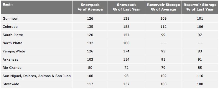
Bump and update Here’s a release from the Natural Resources Conservation Service (Mike Gillespie):

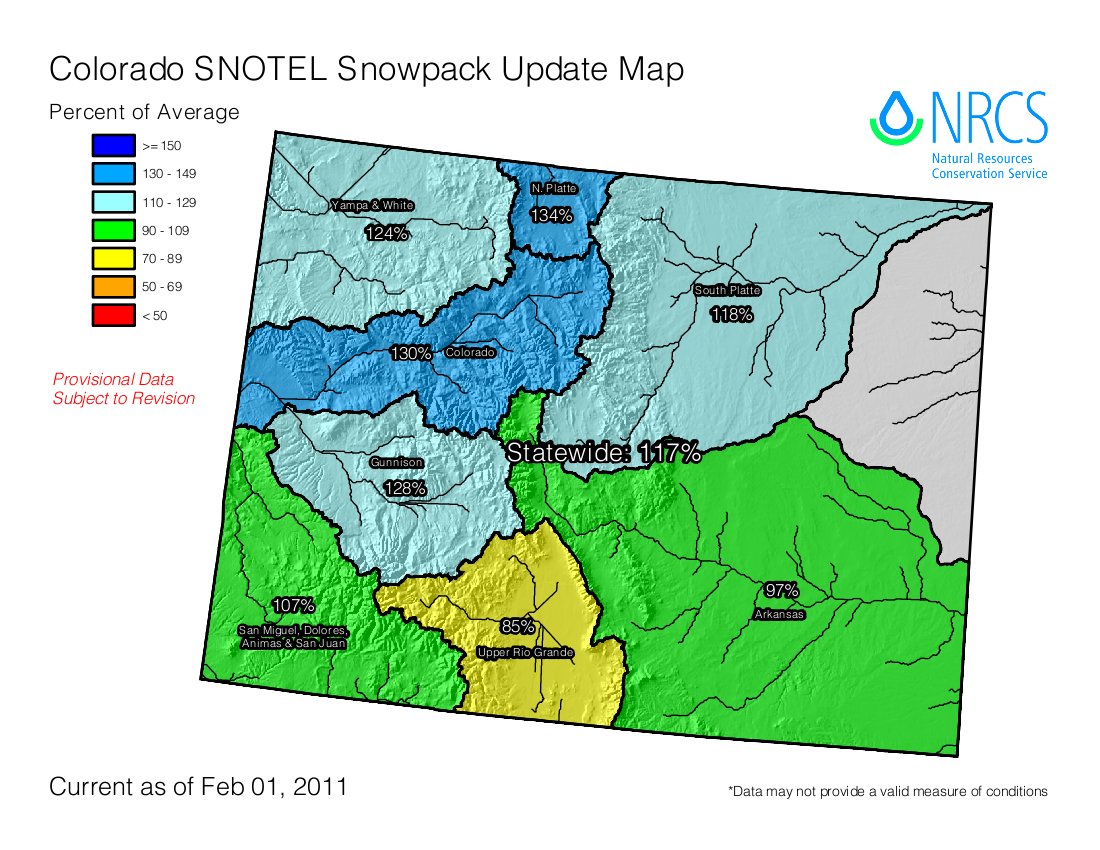
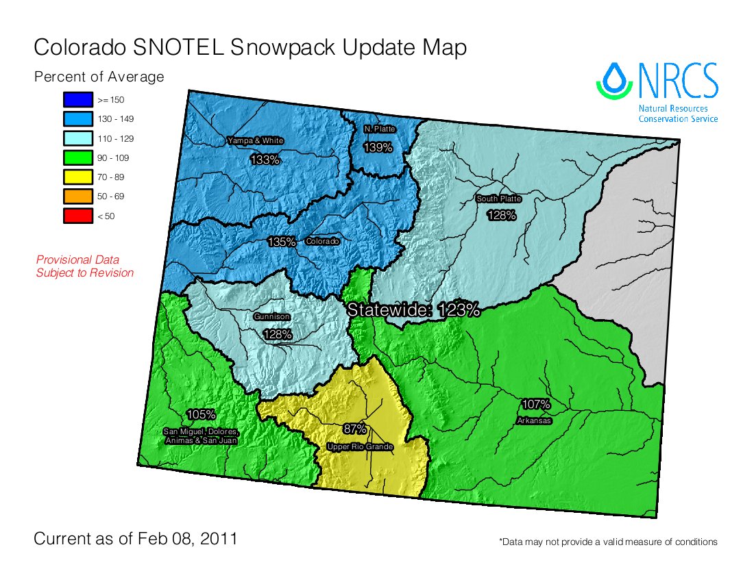
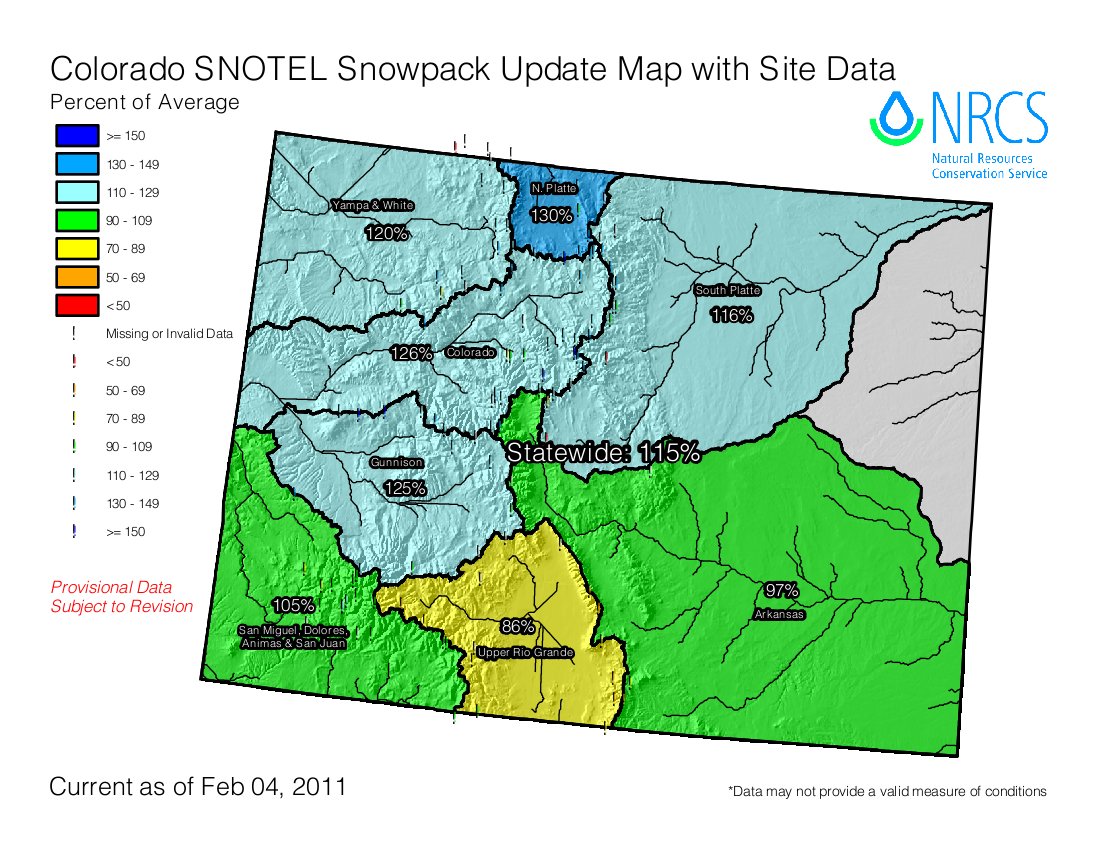
January was a dry month across Colorado which has contributed to significant decreases in the mountain snowpack percents of average across the state. According to the latest snow surveys, conducted by the USDA – Natural Resources Conservation Service (NRCS), Colorado’s statewide snowpack decreased from 136 percent of average on January 1 to 117 percent of average on February 1. Decreases in snowpack percentages were measured in all of the major river basins of the state, according to Allen Green, State Conservationist with the NRCS. While this year’s snowpack is considerably better than last year at this time, the current statewide percentage ties that measured on this date back in 2009.

Those basins across southwestern Colorado experienced the driest conditions during January, recording only about one quarter of their normal precipitation for the month. Snowpack percentages decreased by 38 percentage points in the combined San Juan, Animas, Dolores and San Miguel basins; declining from 144 percent of average on January 1, to 106 percent of average on February 1. Similar decreases were also measured in the Gunnison Basin, decreasing from 158 percent of average a month ago, to only 125 percent of average.

While decreases in percents of average were measured across the state, the February 1 snowpack totals remain above average nearly statewide. Only the Rio Grande Basin has decreased to below average this month at 80 percent of average. “Without those big storms back in December, most of the state would be well below average right now. At this point, they’ve allowed us to endure a dry month, yet maintain good snowpack readings nearly everywhere,” said Green.

Even after experiencing a dry January, the current snowpack remains well ahead of that measured a year ago at this time. With the exception of southwestern Colorado, the 2011 readings are consistently well above those of last year. Statewide totals are currently tracking at 137 percent of those from a year ago.

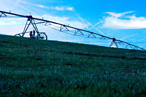
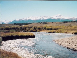
The accumulation of the mountain winter snowpack is critical for Colorado’s water supplies. As much as 80 percent of the state’s annual surface water supplies originate from the melting winter snowpack.

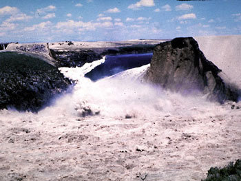
Currently, the NRCS and National Weather Service River Forecast Centers are predicting that this year’s water supplies will be near, to slightly above average in most locations. Given the existing snowpack conditions, only portions of the Rio Grande and Arkansas basins are expecting summer runoff to be below average. With only about 40 percent of the winter snow accumulation season remaining, the next two months will be critical for maintaining the current streamflow forecasts for the state.

More coverage from Bruce Finley writing for The Denver Post. From the article:

“We’ve lost our cushion that we had back in early January from those December storms,” said Mike Gillespie, snow-survey supervisor for the Natural Resources Conservation Service. “We’re not in a panic situation. But it’s not encouraging to see such a sharp decline. “If we don’t get a good snowfall month in February or March and we go into a dry spring, we may be looking back at the December storms as the only good storms of the year. That would be pretty sad.”[…]

In the South Platte River basin that delivers much of the water that sustains the Denver metro area and other Front Range cities, snowpack decreased to 120 percent of average from 126 percent at the start of the year…

Federal analysts are preparing to issue a water-runoff forecast later this week.
They have determined that, from April through July, water shortages are likely in the Rio Grande basin and along some of the southern tributaries near Pueblo and Trinidad that flow toward the Arkansas River. Farmers in those areas can anticipate runoff 30 percent to 50 percent below average unless significant snow happens soon, Gillespie said. The runoff forecast for the South Platte basin still was shaping up as “slightly above average.”

A picture named snowpackcolorado02012011

From Steamboat Today (Tom Ross):

The snow on Buffalo Pass is 10 feet deep…Veteran weather observer Art Judson keeps a pair of snow measurement stakes on Buffalo Pass to track the growing snowpack on a weekly basis. “The U.S. Forest Service took the readings on Jan. 25 and found 127 inches on the northern stake and 111 inches on the southern stake,” Judson reported. The 37 inches of water stored in the snowpack above 10,000 feet at Buffalo Pass on the Continental Divide north of Steamboat already is 128 percent of the average for Jan. 29. Steamboat Ski Area has recorded 252 inches of snowfall at midmountain this season, meaning 10 inches of snow in the coming week would push the ski area past the snow total of 261.75 inches for the 2009-10 season. The 20-year season snowfall average at Thunderhead is 335 inches, according to Steamboat Ski and Resort Corp. records. The record snowfall of 489 inches came in 2007-08…

The snow on the west summit of Rabbit Ears was 66 inches at midweek, but the water content, 23.1 inches, is more impressive than it is on Buffalo Pass in terms of its percent of average. The typical water content on Rabbit Ears at this point in winter is 15.2 inches, putting this week’s measurement at 152 percent of average. The Yampa and White river basins overall are at 128 percent of average.

More coverage from The Grand Junction Daily Sentinel (Dennis Webb):

The state’s snowpack fell from 136 percent of average on Jan. 1 to 117 percent at the start of this month, the U.S. Department of Agriculture’s Natural Resources Conservation Service said. Particularly dry conditions returned to southwest Colorado, which last month received only about a quarter of its normal January precipitation. That area also had started out the winter in poor shape until being hit by giant storms in later December. Drops in snowpack occurred across the state last month, but all basins remain above average with the exception of the Rio Grande, which is at 80 percent…

The Colorado River Basin is at 135 percent of average, down from 147 percent a month ago. Other readings as a percentage of average include the Gunnison and Yampa/White, 126 percent; South Platte, 120; North Platte, 132; Arkansas, 103, and San Miguel/Dolores/Animas/San Juan, 106.

More coverage from Sarah Castellanos writing for the Aurora Sentinel. From the article:

Judging by the snowpack levels taken on Jan. 27, which range from three to five feet, Aurora is on track to receive a quarter of its mountain runoff water supply from [Homestake] reservoir, [Mark Hanratty] said…

Greg Baker, spokesman for Aurora Water, says it’s still too early to know exactly how much water Aurora will collect from Homestake Reservoir. “We get most of our snow, our heavy, wet snow in March and early April — that’s what we actually count on,” he said. “What’s on the ground right now is great if it’s still there on the ground come March or April when we get these heavy snows. That’s bonus time … but this could all go away, or we could get a great reduction.”

On average, the city of Aurora uses between 46,000 and 50,000 acre-feet of water. The city collects a quarter of its water from the Colorado River Basin, a quarter from the Arkansas River Basin, and half from the South Platte River.

More coverage from The Aspen Times. From the article:

At Independence Pass, the snowpack is 125 percent of average, according to NRCS data. The agency also measures the snowpack at three sites each in the Crystal River drainage and the Fryingpan River drainage. Up the Fryingpan, the snowpack was 126 percent of average at Ivanhoe, 121 percent of average at Kiln and 142 percent at Nast Lake. Up the Crystal, the snowpack was 125 percent of average at Schofield Pass, 121 percent of average at McClure Pass and 139 percent of average at North Lost Trail near Marble. For the Roaring Fork basin as a whole, the snowpack is 127 percent of average. The Aspen Skiing Co. is reporting a 40-inch base at mid-mountain at Snowmass and a 62-inch base at the mountain top.