
From The Denver Post (Scott Willoughby):
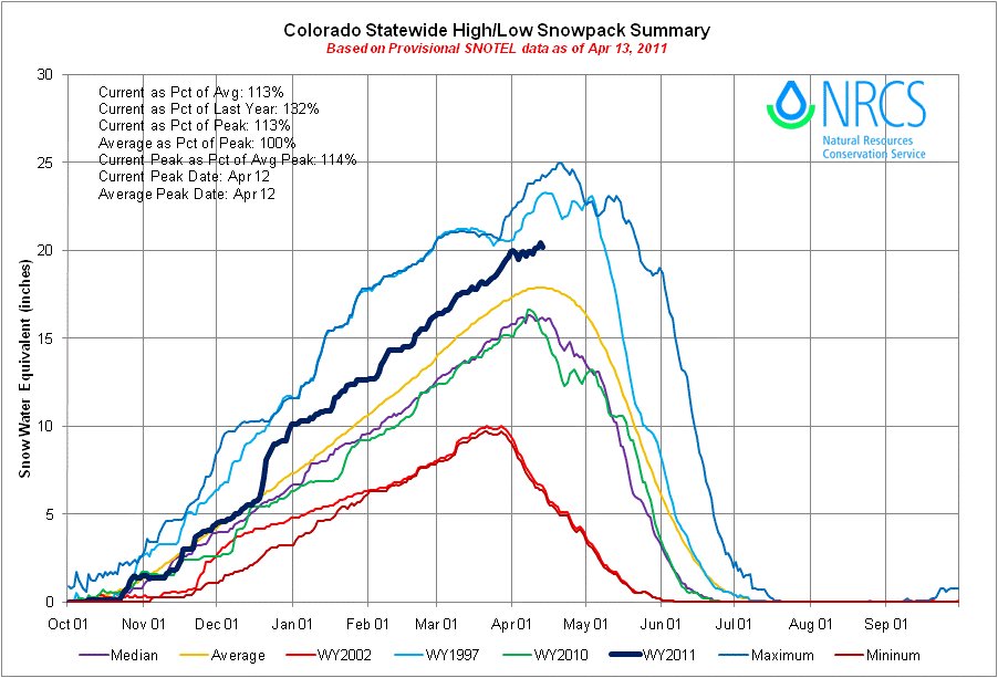
According to the April 1 survey from the USDA Natural Resources Conservation Service (NRCS), the statewide snowpack total was 113 percent of average and nearly 30 percent higher than a year ago. Multiple mountain storms since that date have bolstered the figures, which should translate to healthy river flows. But there’s no telling how the water will come down the mountain. A warm, dry spell typically means short, rapid runoff, while lingering cold and precipitation could extend the melt into summer. Already several Western Slope waterways have started showing signs of life, and increasing turbidity as a result…
River basins in the northern mountains, including the Colorado, Yampa, White and South Platte rivers, are looking at the deepest snowpack since 1996. Currently at 138 percent of average, the North Platte River Basin had the highest basinwide total in the state and the highest for April 1 since basinwide totals began to be calculated in 1968…
Meanwhile, the April 1 readings showed snowpack conditions across the southern mountains decline for three consecutive months, placing the Rio Grande and combined San Juan, Animas, Dolores and San Miguel basins well below average. A late boost of snowfall last week bumped the graph up to 79 percent of average in the Rio Grande basin two days after its April 10 average peak, while snowpack in the combined San Juan, Animas, Dolores and San Miguel basins climbed to 88 percent of average. Some smaller tributary basins in the Rio Grande basin have dropped to nearly 50 percent of average.