Flaming Gorge Task Force’s phase one report is hot off the press

flaminggorgepipelineearthjustice.jpg

Click here to view the report and appendices A through F. Click here for appendices G through I. Thanks to Heather Bergman for sending them along in email. Here’s an excerpt from the report:

Recommendations

In the course of its work, the Committee has come to more fully understand and appreciate the gravity and risks of the status quo and the need to develop new supply1 solutions that balance the current and future consumptive and nonconsumptive needs of both slopes and all basins. The municipal gap on the Front Range is immediate, the dry-up of agriculture is real and certain, and the environmental and economic concerns are serious and numerous. In the process of becoming informed about and discussing the benefits and costs of a specific new supply project focused around Flaming Gorge, the Committee has identified a key threshold step that must happen in order to move beyond the status quo in developing any significant new supply solution: an immediate and focused conversation with each roundtable and state leaders at the table must begin, aimed at developing an agreement or agreements around how water supply needs around the state can be met. Our conclusion and consensus is that the conversation needs to be transparent and inclusive in order to arrive at consensus agreements that can lead to meaningful statewide-level water supply solutions. The immediate need for this robust, focused, transparent, and balanced conversation is at the heart of each of our recommendations.

The Committee has developed a consensus flow chart that identifies threshold steps and a process framework for moving forward with major new supply allocation from the Colorado River. The flow chart and the process it outlines suggests a pathway to achieving statewide consensus for a new supply project, based on roundtables defining the scope of a project, the IBCC and CWCB providing insight and approval, and project proponents or participants designing a project based on statewide consensus about the criteria of what characteristics and components are needed to be included into the design, implementation, and operation of a water project for that project to be considered a “good” project for Colorado. The flow chart is based on several assumptions:

  • The goal is to minimize the risk of a Compact call.
  • An M&I gap exists and needs to be filled. Some of the water needed to fill that gap may come from the Colorado River. That portion of the gap that is not satisfied by identified projects or processes, conservation, or new supply will likely come from the change of agricultural water to municipal and industrial use.
  • The current legal framework will apply.
  • All roundtables are affected by a new supply project.
  • This process would be voluntary. An inability to complete the process (all STOP signs in the complete framework) means that proponents revert to “business-as-usual” for building a new project.
  • More coverage from KUGR News:

    A task force studying issues related to proposals to divert water from the Flaming Gorge Reservoir in Wyoming to Colorado says state leaders first need to agree on how Colorado’s water needs can be met. In a report to be presented to the Colorado Water Conservation Board, the Basin Roundtable Exploration Committee says questions that should be addressed include how Colorado can maximize its entitlements to Colorado River water without overdeveloping the river and who would finance a new water supply project. It also lists characteristics of “good” water supply projects, which it says shouldn’t reduce supplies to existing water users, for one. The report, released Wednesday, says there is an immediate gap between the Front Range demand for water and the supply and mentions “risks of the status quo.”

    More Flaming Gorge Task Force coverage here.

    Forecast news: Series of storms to move across western Colorado today through the weekend #codrought #cowx

    From the NWS Grand Junction Office:

    A disturbance will move across the area today, with light snow across the mountains. 2 to 5 inches are possible in the higher elevations with little to no accumulation in the valleys. At this time, it does not appear strong enough to break valley inversions. A more unsettled pattern will set up for the weekend heading into the coming work week, with a series of systems affecting the area. The first arrives on Saturday from the southwest with milder temperatures generating rain among some lower elevations mixed with snow, with snow above 9000 ft. The second stronger system arrives Sunday and affects the area through at least Tuesday, with widespread snowfall and colder temperatures. (Please visit http://weather.gov/gjt for more information.)

    From Snow.com (Joel Gratz):

    While January started dry, it’ll end snowy. I’ve been tracking this change in the weather pattern for over a week, and while the details are still not set in stone, it does look like the last week of January will offer powder across the I-70 corridor from Beaver Creek to Vail to Breckenridge to Keystone.

    To set the stage, plentiful Pacific moisture is streaming eastward and will saturate the air over Colorado from Thursday (January 24th) through the middle of next week. While this moisture brought a few inches of snow to Tahoe and a few more inches could fall over the weekend, the main story will be snowfall in Colorado.

    One weak storm will bring a few inches on Thursday night (January 24th), and another weak storm will move through southern Colorado and only bring a few inches to the Vail resorts from Saturday afternoon through Sunday morning.

    The bigger story will be the strong storm that moves across the state on Monday night through Wednesday morning (January 30th).

    Weekly Climate, Water and Drought Assessment of the Upper Colorado River Region #codrought #cowx

    wyutcoprecipitation01142013to01202013.jpg

    Click on the thumbnail graphic for the precipitation summary from this week’s webinar. Click here for all the summaries from the Colorado Climate Center.

    More Colorado River Basin coverage here and here.

    Mancos: ‘Water 101’ workshop Saturday

    mancosrivermontezumacountyconservationdistricts.jpg

    From The Mancos Times:

    For all interested people, there will be a meeting at the Mancos Community Center called “Water 101 in the Mancos Valley” on Saturday, Jan. 26, from 10 a.m. to 5 p.m.

    Water will the subject and various people will talk about it. Gary Kennedy, superintendent of the Mancos Water Conservancy District will speak about the Jackson Reservoir; Marty Robbins of the Department of Water Resources will talk about the priority water systems, Brandon Bell of Mancos Rural Water will be there to address any concerns. Questions and comments will be encouraged from all who attend.

    The workshop is hosted by the Mancos Conservation District and will be a good starting point for the discussion on water.

    More Mancos River Watershed coverage here.

    Drought news: Revegetation efforts for the Pine Ridge Fire wildfire area suffer from lack of rainfall #codrought

    pineridgefiremap2012.jpg

    From The Grand Junction Daily Sentinel (Dennis Webb):

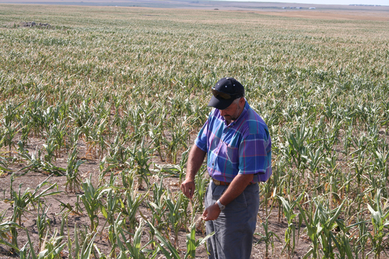
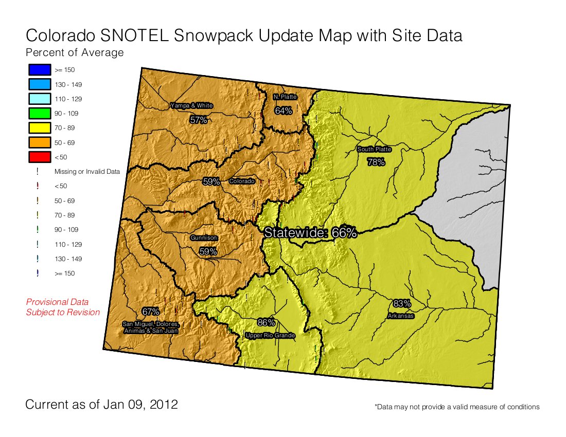
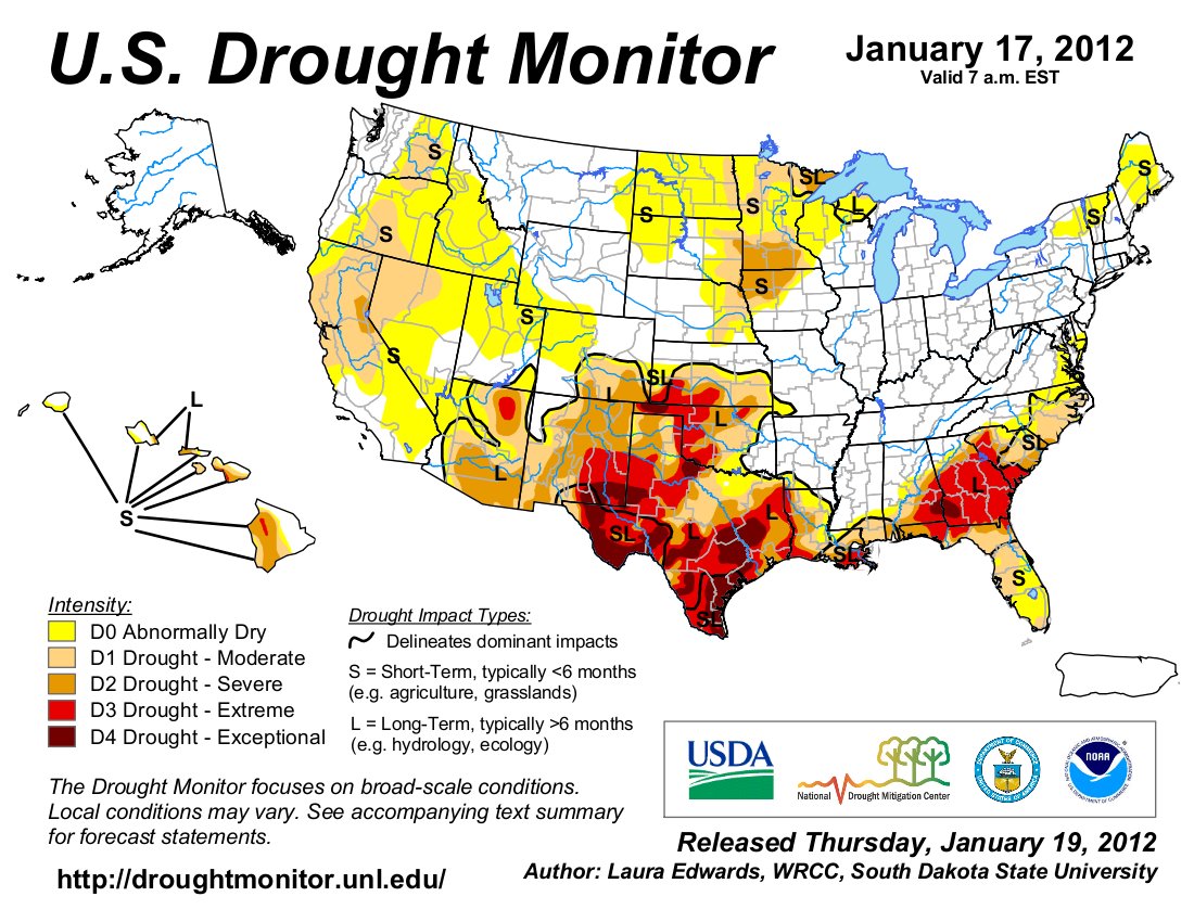
    As if it hadn’t been bad enough that one of Colorado’s worst droughts led to nearly 14,000 acres burning in the Pine Ridge Fire this summer outside De Beque, that same drought has hampered efforts to encourage important regrowth there. Seeding with a temporary cover crop intended to stabilize soil at the fire site, prior to distributing native vegetation seed, failed to result in nearly the kind of germination hoped for by the Bureau of Land Management’s Grand Junction Field Office. There just wasn’t enough rain this summer for the temporary vegetation, marketed under the name QuickGuard, to take root, “which is amazing, because it generally doesn’t take much,” said Wayne Werkmeister, the office’s associate field manager.

    “That goes to show how truly bad it is out there,” he said.

    The drought has made matters even worse for the field office because there were so many other big fires in Colorado this year that competition for reclamation money through the BLM’s fire funding program has been fierce. That meant the local office asked for less originally than it would have otherwise for the Pine Ridge Fire work, and ended up getting even a smaller amount. Nevertheless, officials are buoyed by recent snow on the fire site, and hoping the snow cover will last into early next year, when they hope to carry out aerial seeding of native plant mixes.

    “The more snow you have when you put it on up there, the better,” Werkmeister said. Beyond contributing to moisture, snow helps drive seed into the soil as it melts, and the seed also penetrates into the snow quickly, reducing consumption by birds and rodents, he said.

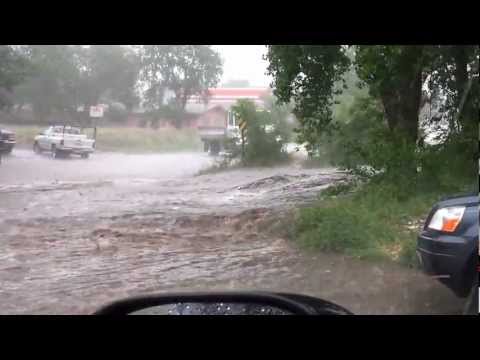
    The Pine Ridge Fire, the biggest in history within the field office’s jurisdiction, burned in late June and early July. The danger presented by acreage denuded of vegetation was made almost immediately evident when a storm shortly after the fire deposited ash and debris into the Colorado River. That forced the Clifton Water District to shut down its river intake for a day and a half because it couldn’t remove the smoky color and odor from the water.

    A big flood coming off the burn area also could threaten the Union Pacific railroad tracks in De Beque Canyon. The BLM installed two gauges designed to help forewarn both Clifton Water and Union Pacific of further big storms, but the summer passed without further major incidents. “We dodged a bullet, so to speak,” said Dale Tooker, general manager of Clifton Water.

    He said the utility supports the BLM’s revegetation efforts. Meanwhile, the fire helped revitalize the district’s planning for infrastructure upgrades that would include a membrane filtration system that would make problems such as ash runoff in the river a non-issue. Clifton Water is raising its rates starting next year as it prepares for such upgrades, which had been considered years ago but were put off by the recession.

    Sagebrush and wildlife

    Revegetation efforts at the fire site also are important to trying to minimize the spread of cheatgrass, an invasive, nonnative species that can dominate landscapes. It dries out early in the year, which can lead to even more fires and more cheatgrass.

    In addition, revegetation is important to wildlife, providing food and cover. Fire can benefit wildlife habitat to some degree, leading to a more diverse landscape if it burns in mosaic patterns, as in the case of Pine Ridge Fire, which skipped over parts of the area within the burn perimeter. Still, there was loss of areas such as sagebrush parks that are important to deer and also have been eyed as potential habitat for the imperiled greater sage-grouse. Jim Dollerschell, a BLM rangeland management specialist, said sagebrush doesn’t resprout after a fire. This fall, crews tried to gather seeds from adjacent sagebrush parks and spread them in burned areas. “Unfortunately this year sagebrush seed was pretty sparse due to the drought,” he said.

    The QuickGuard cover the agency spread consists of a sterile, annual plant, meaning it’s intended to immediately stabilize the soil but not reproduce and compete later with native plants. Its dead remnants also can provide cover from moisture-sucking wind and withering summer sun once native plants start to grow. It’s so receptive to a little moisture that some of it that spilled along the runway at the Garfield County Regional Airport, where it was raining lightly as crews took off to seed the fire site, germinated a few days later. But as of late in the year, many burn areas continued to look barren due to the meager growth of the plant. It could germinate this spring and still provide benefits. But Werkmeister said it also now will be growing along with the native perennials that will be planted by air this winter, and will likely outcompete them and hinder their growth if there’s not that much moisture. He’s hoping the spring will be wet enough for both the QuickGuard and native plants to thrive.

    The seeds alone, consisting of species such as Indian ricegrass and bottlebrush squirreltail, cost the BLM almost $900,000. The BLM will apply three different mixes — one for areas of best growth potential, one for steeper, rockier slopes, and one for areas where there’s already a cheatgrass problem. That latter mix includes species that compete well with cheatgrass, including a nonnative species, tall wheatgrass.
    Flooding concerns

    The field office had asked for $1.9 million for the fire rehabilitation work, but will end up with about $1.5 million. It had hoped to use some funds to build retention ponds designed to keep silt from reaching waterways in flooding, but wasn’t able to get that work started before Oct. 1, the start of the next federal fiscal year. Dollerschell said because there was so much fire activity going on around the West, funding wasn’t carried into the new fiscal year and the ponds won’t be built. Existing ponds in the area did their job in catching sediment, though, without being breached or damaged, he said. “So it’ll be a focus for us in the next year or so to get those cleaned out so that their capacity is increased again,” he said. He said canyons in the area “have a lot of rock and armor in them, so if you do get some sediment runoff they’re going to capture a lot of that.”

    Werkmeister said the field office didn’t get adequate funding to maintain the two storm warning gauges for the next two years, so it may be asking Clifton Water and Union Pacific for funding assistance.

    Also, it was unable to get money to pay for seeding of forbs, plants particularly beneficial as browse for wildlife, because the BLM fire program had only enough funds to focus on seeds that primarily encourage watershed protection, Werkmeister said. However, Chevron and the National Wild Turkey Federation chipped in $10,000 apiece for forbs seeding.

    The High Lonesome Ranch, which had property burn in the fire and also is a grazing permittee in part of the fire area, has agreed to contribute the use of heavy equipment for some of the revegetation work.

    Protected cactus

    The area of the fire continues to be closed to all but specially approved uses, meaning activities such as hunting and recreational access aren’t allowed. “When you get a fire like that … in some areas it creates like a moonscape and it’s very enticing to individuals to do cross-country travel because there’s nothing there to stop them,” Dollerschell said. That can add to erosion and creation of new trails.

    The closure will aid in the revegetation work and provide protection to sensitive resources, such as the federally threatened Colorado hookless cactus. Seventeen of the plants are known to have burned in the fire.

    If the drought continues into next year and seeds don’t germinate, that would be bad in the short term as far as trying to stabilize erosive slopes. But the seeds still could grow in following years.

    The 2011 Cosgrove Fire, which burned some 1,700 acres near the Pine Ridge Fire, was reseeded by air last March.

    “Because it was so dry we had no seed germination or very little seed germination, which was probably a positive thing because if it would have germinated, the fact that April, May and June were so dry, even July, those seedlings would have fried, would have died,” Dollerschell said. That seed may germinate this spring, however. “We’ve found that that seed can sit in the soil, on top of the soil for three-plus years and we still get some response,” he said.

    From NBC11News.com (Taylor Termby):

    Water experts worry the inversion may also be giving some an inaccurate picture of the drought. “We do still have a ton of snow down here in the Valley, but that’s snow that fell a long time ago,” Colorado Mesa University Water Center coordinator Hannah Holm said.

    Though temperatures are much colder than years past, many areas in Colorado (including the mountains) are warmer than they should be for this time of year. “[Snow] just hasn’t been piling up in the mountains like it should. Each week the picture gets just a little bit worse,” Holm said.

    Snowpack news: ‘As bad as last year was…this year we’re behind it; we’re worse’ — Cory Gates #codrought

    snowpackcolorado01222013.jpg

    From The Aspen Times (Andre Salvail):

    So far this month, 2.5 inches of snow has fallen on the city. If Aspen only receives another 2.4 inches between now and Jan. 31, then the record-lowest January snowfall total of 5 inches in 1961 will be broken.

    “We still have a shot at the record,” said Cory Gates, a forecaster with AspenWeather.net. “I think it’s guaranteed top-five.”

    The chances for significant snowfall between now and the end of the month are iffy, according to Gates. Above-normal temperatures in the 40s and sunny skies will be in play today and Wednesday. A weak cold front is expected to pass through the area Thursday, bringing a slight chance of snowfall of less than an inch…

    In December, 34.8 inches of snow was recorded at the city’s water-treatment plant off Doolittle Drive. The return of decent snowfall, following an extremely dry December 2011, a drought in March and April 2012 and very little snowfall in October and November just prior to the current ski season, was seen as an encouraging sign.

    January has dashed some of that optimism.

    “As bad as last year was and everybody complaining, this year we’re behind it; we’re worse,” Gates said. “We have less snow this year than last year. The bases at the resorts are only like 21 inches right now, which is terrible. That’s pathetic.”

    Drought news: Colorado crop production down in 2012 #codrought

    usdroughtmonitor01152013.jpg

    From the North Forty News (Doug Conarroe):

    According to the Jan. 11 report, Colorado wheat production fell 9.3 percent, from 81.8 million bushels in 2011 to 74.8 million in 2012 even though acres harvested increased by 6.7 percent — from 2 million acres in 2011 to 2.2 million acres in 2012.

    Corn production dropped 29 percent in 2012, to 134.3 million bushels, from the 2011 total of 172.9 million bushels. 1.42 million acres were planted in corn in 2012 versus 1.5 million acres in 2011. The corn yield stayed the same from year to year, at 133 bushels per acre.

    “The drops in output from 2011 to 2012 are hands down due to the drought,” said Bill Meyer, NASS Colorado field office director.

    And 2013 doesn’t look good, according to Meyer. So much so that some Northern Colorado farmers are moving from corn crop to less moisture- and irrigation-dependent crops such as wheat.

    “Farmers still had subsoil moisture in early 2012, plus the reservoirs were full from the heavy runoff from 2011′s snowfalls,” said Meyer. “Because of drought conditions we don’t have that much-needed subsoil moisture this year, and the reservoirs are low.”[…]

    Production of Colorado hay alfalfa dropped ten percent in 2012, to 2.6 million tons, from the 2011 total of 2.88 million tons. 750,000 acres were planted in hay alfalfa in 2012 versus 800,000 acres in 2011.

    U.S. Representative Diana DeGette co-sponsors H.R. 267 — Hydropower Regulatory Efficiency Act of 2013

    microhydroelectricplant.jpg

    Click here to read about the bill on GovTrack.us

    From The Telluride Daily Planet (Collin McRann):

    The legislation comes in the form of a bill called the Hydropower Regulatory Efficiency Act. It was reintroduced to the U.S. House of Representatives Jan. 15 by lawmakers from Colorado and Washington state. Though an identical bill was shot down in the Senate late last year, it did pass the House in July by a unanimous vote. The bill’s main focus is to clear much of the red tape associated with permitting small hydroelectric power projects, mainly those generating less than 5-megawatts of electricity.

    Both U.S. Rep. Diana DeGette (D-CO) and U.S. Rep. Cathy McMorris Rodgers (R-WA) co-sponsored the bill, and one of its major supporters is the Colorado Small Hydro Association. Ophir’s Kurt Johnson is president of the association, and in the past he has promoted the benefits of small hydroelectric projects…

    Regulations currently in place require most hydroelectric projects to go through an application process and review with the Federal Energy Regulatory Commission (FERC). The FERC process can be lengthy and expensive, which can create a burden to small projects.

    If the new bill is passed into law, the regulatory process could be streamlined for certain small hydro projects. The bill, as written, provides periods of public comment and directs FERC to examine the feasibility of a two-year licensing process for certain low-impact hydropower projects. Some of the low-impact projects could include the conversion of existing non-powered dams into power-generating ones.

    According to the association, the current permitting process has been a barrier to small projects for decades. As a result the association claims much of Colorado’s, and the country’s hydroelectric resources are under utilized.

    Historically, western Colorado has had a number of small hydroelectric projects, including the Bridal Veil hydroelectric power station above Telluride. Bridal Veil along with the Ouray Hydroelectric Power Plant in Ouray are two of the oldest AC power plants in the country…

    The bill states a significant amount of new hydroelectric generation could come from maximizing existing infrastructure, particularly non-powered dams. It states that only about 3 percent of the nation’s 80,000 dams currently generate hydropower.

    More hydroelectric coverage here and here.

    South Platte River Basin: DWR Sterling Groundwater Monitoring Effort

    vibratingwirepiezometer.jpg

    Click here for the Sterling Groundwater Monitoring Effort website from the Colorado Division of Water Resources. They write:

    Homeowners have relayed their concerns about high groundwater levels in the Country Club Hills and Pawnee Ridge subdivisions in Sterling to state officials. The DWR and CWCB are conducting an independent analysis at each subdivision. The agencies have undertaken an effort to monitor groundwater levels and characterize the hydrogeology within the areas of interest. The objective of this groundwater monitoring is to identify relationships between the hydrology of the area and the high groundwater levels. Preliminary information and data obtained from this investigation is updated monthly.

    Here’s a report from David Martinez writing for the Sterling Journal-Advocate. Here’s an excerpt:

    Ralf Topper, senior hydrogeologist at the DWR, said at a community meeting that results so far show that a mix of geologic deposits and structure – in terms of bedrock – have an effect on the level of water tables.

    Several area farmers and residents have complained of low water tables, or levels below ground that are completely saturated with water. Spots with water tables as high as at four of five feet below the surface can damage crops and cause basement flooding.

    So the DWR and the Colorado Water Conservation Board started conducting an independent analysis of the city’s subdivisions.

    The agencies are monitoring groundwater levels and characterizing the hydrogeology around the city. The goal, according to the DWR, is to find relationships between the area’s hydrology and the high groundwater levels.

    “We’re looking at all of the inputs and outputs,” Topper explained. “Why are groundwater levels changing? What’s the mechanism for changing?”

    He added that they’ll collect data on stream flows, diversions, recharge ponds, climate and large capacity oil pumping. All of that will then go to third party consultants to analyze.

    The DWR has studied 16 piezometers – devices that measure groundwater pressure – between the Sterling subdivisions of Country Club Hills southeast of Northeastern 18 Golf Course and Pawnee Ridge north of County Road 30 and east of Ballpark Road since May.

    From the measurements, the DWR found that the geology from spot to spot varied between thick and thin layers of gravel, sand, clay and shale (bedrock).

    The clay is important, Topper said, because water levels where clay exists tend to be shallower.

    “(The results) gave us an indication that we’re really looking at a system that is highly variable in terms of the subsurface,” he said. “The assumption was (the land’s) homogenous…. Everyone says it’s sand and gravel. What we’re finding in this area, it’s not the case.”

    And the water tables can vary in any given spot, as well.

    “Nested” piezometers, which measure at different levels from the same bore hole, showed that water tables existed in as many as three layers in Country Club Hills. Some tables were as shallow as three feet, while others were as deep as 24.

    More South Platte River Basin coverage here.

    Montrose County ponies up $50,000 for whitewater park engineering

    uncompahgrevalleylookingsouthtowardsneffels.jpg

    From the Montrose Daily Press (Will Hearst):

    The greater Montrose community came one step closer to a collaborative application for a Great Outdoors Colorado grant Tuesday, after the city locked in an agreement with Montrose County for $50,000 toward the engineering of the whitewater park project.

    All five city council members voted to accept the $50,000 offered, which will not only help cover the upfront design costs, but make for a much stronger application to GOCO because of the multi-agency participation. In exchange, the county asked that the city contribute an equal amount to an improvement project in the future to the fairgrounds or other county asset.

    Councilor Bob Nicholson, while on board with the plan, hesitated at the way a letter worded the county’s agreement. Nicholson said he was more than willing to keep the city’s side of the bargain, but had assumed the county would ask for repayment only for fairgrounds improvements.

    More Uncompahgre River coverage here and here.

    Snowpack news: Statewide = 62% of avg, Upper Colorado = 59%, Arkansas = 54% #codrought

    snowpackcolorado01172013.jpg

    From The Denver Post (Joey Bunch):

    We don’t have much of a winter,” said National Weather Service meteorologist David Barjenbruch. “We’re definitely stuck in a rather warm, dry pattern for at least the next week.” More broadly speaking, a high-pressure pattern has dominated Colorado’s atmospheric conditions for a second snow season in a row. “It’s blocking the winter weather from us,” Barjenbruch said.

    State Climatologist Nolan Doesken said last week that long-term indicators don’t yet indicate whether March — typically Denver’s heaviest snow month — or April and May could be wetter or drier than normal.

    The statewide snowpack was just 62 percent of its 30-year average for this time of year as of last Thursday, 59 percent of average in the ski resort-rich Colorado River basin and 56 percent of average in the South Platte River basin, which includes Denver.

    From the Summit Daily News (Caddie Nath):

    Following a record low snowfall season last year, Summit County is currently in the midst of a severe drought. Despite a summer marked by stringent fire bans and water restrictions in 2012, A-Basin is the only local resort where dry conditions have impacted snowmaking this winter.

    A complex system of water rights, reservoir storage and agreements kept Breckenridge Ski Resort, Copper Mountain and Keystone Resort snow guns well supplied this winter.

    “Our water agreements give Copper a buffer every year,” resort spokeswoman Austyn Williams stated in an email to the Summit Daily. “During this season’s snowmaking, Copper did not experience any drought-like effects.”

    Water rights allow the ski areas to pull a certain amount of water from local streams, so long as those streams don’t drop below a specified level. But Copper and Breckenridge both enjoy the safeguard of nearby water storage — Clinton Reservoir for Copper Mountain and Goose Pasture Tarn for Breckenridge. Both resorts can pull some water from storage to supplement streamflows when necessary.

    Keystone’s backup plan is an agreement with Denver Water, the utility company that owns Dillon Reservoir. The resort is able to pump some water from Roberts Tunnel, which directs water from the reservoir toward its route down to Denver, according to Troy Wineland, state division of water resources water commissioner for the Blue River Basin…

    In Breckenridge, the Blue River continues to run low, despite the end of snowmaking operations. But officials say current flows are normal for this time of year, considering the dry conditions.

    Because of the drought, in January, February and March, the town of Breckenridge is diverting a portion of the Blue River streamflows to be stored for municipal use and future snowmaking efforts, further reducing the water levels, according to a report from the town.

    From the Summit County Citizens Voice (Bob Berwyn):

    [Dr. Jennifer Francis] has been studying the connection between vanishing Arctic sea ice and weather in the mid-latitudes of the northern hemisphere, and evidence is piling up that the intense warming at high latitudes has serious implications for North America, Europe and Asia. Francis sprinkled her scientific talk to broadcast meteorologists with climate change warnings, pointing out the need to make drastic cuts in greenhouse gas emissions.

    “The amount of ice loss this summer is just such a stunning example of climate change. This is a real problem, a big problem, it’s happening now, not generations from now and we need to do something about it,” she said, going to recite a litany of extreme weather events in recent years, from floods in Venice and China to extreme winter weather in Europe and last summer’s record-setting heatwave in the U.S.

    “We’re just now starting to make the connection between weather and climate … But I think we can all agree that the last few years, Mother Nature in the last several years has dished up an incredible smorgasbord of extreme weather,” she said.

    As a result of recent events, Francis said she’s noticed a change in the tone of the conversation about climate and weather. People aren’t shying away from making the connection anymore.

    “The high northern latitudes is where the warming is happening the fastest … And we’re starting to see the impacts,” she said. “The high latitudes are going to get even wetter, dry areas are going to get even drier. There are going to be more precipitation extremes in both directions … “We have changed the deck of cards that we are playing with in terms of the climate system … When you take out some of the low cards, you have a much better chance of getting high cards,” she said.

    Francis then zeroed in on the Arctic, where temperatures have warmed twice as fast as rest of northern hemisphere, with the greatest warming trends in the winter and fall. The greatest temperature anomalies are at the surface, but extend all the way through the troposphere. “The last time the Arctic was this warm was 125,000 years ago, and sea level was six to eight meters higher than now … This is really bad news,” she said. “The volume of ice 80 percent less than just a few years ago,and what’s left is broken, thin, rotten slushy,” she said.

    The current increases in atmospheric CO2 concentrations are happening so quickly that Earth’s temperatures are still lagging way behind. “There’s no reason think it won’t keep getting warmer … Going back about 450,000 years into the past, the relationship between CO2 and and temperatuers is very clear. CO2 is at levels not seen for 650,000 years, we have a long way to go to catch up,” Francis said…

    If you warm the Arctic more than the mid-latitude, it’s weakening the gradient, and that’s what drives the jet stream, and it’s weakening. It started to drop off when the sea ice started to disappear. When the jet stream is weak and sluggish it meanders more. The large -scale waves tend to not move very fast,” she said.

    “We tend to see cut-off lows and blocking highs. What we’ve seen is that the maximum latitudes, the peaks of ridges migrating northward, especially since sea ice really started to disappear in early 90s, particularly in the North Atlantic, with more ridging around Greenland … The storm track in the Pacific is moving northward,” she said explaining that that movement is also linked with increased ridging…

    “The word is not getting to the people who need to hear it and operate on that information,” she said. “There have been organizations out there who have deliberately tried to cover up the evidence of climate change. A lot of money has been spent on trying to confuse the issue.

    “If there’s any doubt, people would rather hear the story that’s not so discouraging. But people are starting to see the evidence with their own eyes, they’re realizing the disinformation that they’ve been served is wrong,” she concluded.

    Gilcrest: South Platte River Basin groundwater public meeting Thursday

    southplattealluvialaquifer.jpg

    From The Greeley Tribune:

    The public is invited to Gilcrest on Thursday to attend the last of three meetings about the ongoing groundwater study in the South Platte River basin. The study, being conducted by the Colorado Water Institute at Colorado State University, is studying groundwater’s interactions with streamflows and how current augmentation requirements are impacting the alluvial aquifer.

    Earlier this year, Colorado House Bill 1278 was passed, authorizing the comprehensive groundwater study, which is the first since 1968, according to CSU officials. Members of the Colorado Water Institute study team have already met with the public in Longmont and Sterling this month to talk about the study, which will conclude at the of this year.

    They will have another public meeting from 6­8:30 p.m. Thursday at Valley High School, 1001 Birch St. in Gilcrest.

    More South Platte River Basin coverage here.

    Forecast news: Possible widespread snow after the weekend #codrought #cowx

    screen-shot-2013-01-21-at-9-59-31-am.png

    Proposed Colorado Springs’ stormwater actions on Fountain Creek will likely go to the voters

    floodingcoloradospringsjune62012.jpg

    From The Pueblo Chieftain (Chris Woodka):

    Colorado Springs is looking at several options to secure stormwater funding, any of which would most likely mean a vote of the people. “Technically, it’s possible to implement it as a fee, but it has to be in front of voters politically,” Colorado Springs Utilities executive Mark Pifher told the Pueblo Board of Water Works this week.

    Pifher updated the board on the work of a stormwater task force created by El Paso County commissioners and the Colorado Springs City Council. The task force decided to recommend the county and cities study ways to find sustainable funding for more than 400 projects and $900 million in funding needs identified in the first phase.

    Commissioners and the City Council are considering the recommendation.

    The issue is of concern to Pueblo because the stormwater from the most populated areas of El Paso County funnels into Fountain Creek and could make flooding worse if not controlled. There is urgency in El Paso County because of commitments to Pueblo County for a permit to construct the Southern Delivery System and increasing damage from stormwater structures in place.

    A white paper last year by Summit Economics outlined several possible funding sources, Pifher explained.
    A new El Paso County entity, similar to the Denver Urban Drainage and Flood Control District, could be formed or the payment for stormwater could be managed by the Fountain Creek Watershed Flood Control and Greenway District. Another possibility would be to create a stormwater utility for Colorado Springs, which already operates gas, electric, sewer and water utilities.

    Colorado Springs City Council abolished the city’s stormwater utility, created without a vote of the people, in 2009, after anti­tax activist Doug Bruce persuaded voters to approve city Issue 300, calling the stormwater fee a “rain tax.”

    More stormwater coverage here.

    New Roxborough Water and Sanitation District water treatment could cost $23 million

    roxboroughstateparkcpw.jpg

    From the Castle Rock News-Press (Rhonda Moore):

    The Roxborough water treatment plant, at more than 50 years old, has lasted beyond the end of its useful life and, according to the district board, it’s not a matter of whether disaster will strike, it’s a matter of when. The district is waiting to hear from its customers who must decide how to pay for a new facility, estimated to cost as much as $23 million.

    The new plant will replace the one purchased in 1972 from Aurora Water, according to the district. The existing plant was built in 1958 and refurbished at the time of the purchase. It has outlasted its expected 30-year lifespan by about 20 years, according to the district board…

    Completion of a new facility will cap a long-term water plan that ensures delivery of water to Roxborough residents for the next 100 years, he said.

    Moore was instrumental in reaching a 2010 deal with Aurora Water to get water to Roxborough residents in what Moore calls the most comprehensive, sustainable water plan in Douglas County. In the deal, Roxborough signed a 99-year lease with Aurora to buy into the Aurora system for $22.3 million, securing water to serve Roxborough’s build-out population of 3,800 units. The deal does not allow Roxborough to sell water outside of its boundaries, which means the Roxborough plant will not be designed to serve residents in surrounding neighborhoods, including the proposed Sterling Ranch development, Moore said…

    The district announced its plans in 2012 and in December sent a questionnaire to customers asking them to select one of three payment options for financing the new plant. Among the options are a $20 monthly hike in water rates, beginning in March or April, which would allow the board to move forward with design and financing in the first quarter of 2013; a $10 fee, which would double to $20 by 2014 and delay the start of construction by about 12 months; or a $5 fee that would increase every six months to a $20 fee by 2014, which would delay start of construction by about 18 months.

    The district has about $5 million in capital reserves to contribute to the plant and is aiming for a 30-year note to pay the balance, Moore said.

    Moore has been fielding residents’ questions, many of which revolve around the district’s policy to limit outdoor watering during the summer to twice a week. The board has yet to vote on watering restrictions, Moore said. The new plant will have a 4 million-gallon-per-day treatment capacity, double that of the existing plant.

    More infrastructure coverage here.

    Arkansas Valley Conduit: ‘Water resources are not a priority with this Congress’ — Christine Arbogast

    arkansasvalleyconduitproposed.jpg

    From The Pueblo Chieftain (Chris Woodka):

    Secretary of Interior Ken Salazar’s upcoming resignation and the political climate in Washington could have consequences for the Arkansas Valley Conduit. “We need to double our effort at Interior to secure funding for the conduit,” lobbyist Christine Arbogast told the Southeastern Colorado Water Conservancy District Thursday.

    Salazar, who battled for the conduit when he served in the U.S. Senate, understood the project, which is being studied by the Bureau of Reclamation, which is part of Interior, she said. “If funding slips, the schedule slips and the costs go up,” she said.

    The environmental impact study for the $500 million conduit should be complete before the end of this year. Reclamation will decide the best route for the pipeline which would supply water to 50,000 people in 40 communities east of Pueblo. While funding for the study has remained in place through shaky fiscal times in Washington, the funding for the conduit itself never has been guaranteed. If everything stays in place, the conduit could be built by 2022. That implies annual appropriations would be made by Congress.

    “Water resources are not a priority with this Congress,” Arbogast said. “Water is a back-burner issue. It has a low profile and a low priority.”

    The conduit was part of the 1962 Fryingpan-Arkansas Project, but was not built because of the expense. A 2009 bill passed by Congress provided funding through excess-capacity contract revenues to repay the costs of building the conduit.

    More Arkansas Valley Conduit coverage here and here.

    Landowners are watering cattle and wildlife with produced water from coalbed methane operations

    coalbedmethaneproductionearthjustice.jpg

    From The Pueblo Chieftain (Chris Woodka):

    The forests in the hills west of Trinidad are filled with green pipes, industrial structures and constant signs that warn outsiders against both trespassing and smoking.

    This is natural gas country. It’s also cattle country, fish country, elk country and home to rugged individualists who see the water produced by coalbed methane operations as a godsend rather than a threat. “It’s been a blessing,” says Karen Salapich, a rancher who has organized her neighbors to push back against oil and gas regulations that could require companies to re­inject all water produced by drilling into deep aquifers where it might never be used. Dozen of others agreed during a daylong tour of places tucked into the hills west of Trinidad. These people acknowledge that some of the water coming out of the ground may be awful, but say a lot of it is not — particularly in their area.

    They are asking state regulators not to waste water that could otherwise be used. “We’ve has a problem with drought and the county has lost a third or more of its livestock. If we didn’t have the CBM water, there wouldn’t be any. People couldn’t continue,” Mrs. Salapich said. CBM stands for coalbed methane…

    Past practices by some companies in nearby Huerfano County have caused problems for
    landowners who say produced water of poor quality ruined cropland. But in Las Animas County, many have conducted their own tests of water and found it to be of sufficient quality to support wildlife and livestock. They have photographed herds of elk and other animals drawn to CBM water holding ponds.
    Todd Huffman is even using it to raise fish.

    “It’s like a wildlife park,” Huffman says of Mitotes Lake, which he owns. “People come out here thinking they’ll see a nuclear waste dump, but look at it. It’s beautiful. . . . Take away the water and it’s gone.”

    From The Pueblo Chieftain (Chris Woodka):

    Gary and Karen Salapich lease their property near Gulnare for gas wells, but unlike some of their neighbors, have no water discharges on their property. It’s been so dry, they wish they did.
    They first found out about CBM when a line carrying water broke on their property about five years ago and accidentally irrigated one of their hay fields. “The state wanted to know what the damage was,” Mrs. Salapich said. “Damage? That was the only area that grew,” her husband added.

    Salapich is a native — his father was the postmaster at the dwindling town of Gulnare — and said methane has always been a problem with wells. While driving, he pointed out an old open­pit coal mine above a spring. “That water goes right through a coal seam, so it’s the same as CBM. In my own well, I hit water at 500 feet, but went through a coal seam to go down to 600 feet. You always find gas, but that’s why you vent your well house, to let it escape,” Salapich said. “My well has been here forever.”

    He believes the area’s climate has become drier in the past decade and that CBM water is the only way some of his neighbors have been able to continue to ranch.

    The Salapiches say not all of the water coming up is of good quality, but believe requiring the energy companies to deep­inject all of it would be a waste. They have organized neighbors and attended state rule­making hearings on the use of water. At issue now is how water quality, as determined by the Colorado Department of Public Health and Environment, will affect its use.

    In the Purgatoire River basin to the south, the water from hundreds of gas wells flows freely into the watershed through pipes at many points. It’s turned dry creeks into streams and created wetlands. The Norwest Corp., consultants for the energy companies are monitoring streams for water flow patterns and water quality impacts throughout the Raton Basin.

    In the Apishipa River basin, where drilling came later, more water is kept in open ponds, where it is supposed to evaporate. Those ponds have become vital to wildlife and livestock, however.
    More recent state regulations require the ponds to be lined, so they have to be fenced because animals slip on the slick materials used to line ponds.

    “We don’t want to see the water taken out,” Mrs. Salapich said. “It has good qualities.”

    From The Pueblo Chieftain (Chris Woodka):

    Even without wildlife, Mitotes Lake is a beautiful sight on a chilly winter day. On most days, it’s teeming with critters. Todd Huffman, a Trinidad taxidermist, bought the lake and surrounding land — including the mineral rights — from the state in the early 1980s. The lake, actually a fairly large pond, is fed by flood water in the drainage, and more recently coal bed methane water releases. “There have been years when it was really low,” Huffman said. “One year I lost all my fish.”

    The lake level has stabilized, even during the drought, because of the water released from coal bed methane wells. And it has improved the environmental conditions. Water quality is important to him because he raises koi in a greenhouse near the lake. The water coming out of his wells is warm and sometimes he has to add salt to it to kill the algae.

    He spends thousands of dollars each year to test the quality. “That water’s a godsend to me,” Huffman said. During the drought, Mitotes Lake has been an oasis for wildlife. “I have a photo with about 200 elk, two bears, turkeys . . . It’s like Noah’s Ark dumped off on the place,” Huffman said. “If they were dumping water that was nasty, everybody would be complaining.”

    From The Pueblo Chieftain (Chris Woodka):

    Ranchers west of Trinidad say the flow water from gas drilling has allowed them to stay in business during the recent drought. “It is so valuable to us,” said Bill Brunelli, who ranches in the Apishipa River drainage area and works for the Huerfano County road and bridge department. “The wells are getting weaker and weaker, and the produced water has helped a lot of people out.”

    Where there are holding ponds for coal bed methane water, ranchers don’t have to haul water for cattle, he explained. “If this water goes away, 100 head of my cows are going away,” said Gary Mestas, a rancher who often hauls water to his grazing cattle, but feeds some near mined water releases.

    Many ranchers were forced to sell off their herds following the 2002 drought, but have been able to hang on to at least some cattle through the drought of the last two years. “We don’t irrigate with the water, but we have a discharge on the property,” said Brent Tamburelli, who ranches with his wife Tami near Cokedale in the Purgatoire River basin. “Up until the 1980s we always had runoff because of the snowpack, but the weather has changed.”

    The Tamburellis, who also have a gravel business, have cut their herd to about one-­fifth of the size it once was. But without any water in the recent drought, they’ve managed to keep some breeding stock. He said his great­grandfather once rand 1,000 head of goats on the ground. The stream cutting through the property would be completely dry without the coal bed methane water, he said. “Any use for it would be better than pumping it back into the ground,” Tamburelli said.

    From The Pueblo Chieftain (Chris Woodka):

    Fred Eichler started his career as a guide, then “lucked into” writing for hunting magazines and hosting television programs for hunters. Eichler and his wife, Michele, host several shows for the Sportsman Channel as well as hunters in the hills near Aguilar. They’ve stalked game all over the world.
    Without water, they would be forced to go global more often. For the past two years, coal bed methane water has been keeping the animals near their property alive. “When we have a fire down here last year, they were pulling water out of one of the discharge ponds,” Eichler said.

    Michele pulls up video of elk wading into the water, photos of tadpoles swimming right under the discharge pipe and before­and­after pictures of wetlands dried up when a discharge was stopped. “There’s not a negative to it, and if there was I’d be the first to complain. It’s good for fire mitigation, wildlife, cows and horses,” Eichler said. “There has been so much negative publicity and flat out lies.”

    The Eichlers paid for independent testing of a discharge on their property. The only drawback was some ponderosa pines that died when the ground became waterlogged. “It’s an emotional issue, but everyone we’ve talked to wants the water,” Michele said. “This is an arid, dry climate. . . . For the company the water is waste, but it’s been a huge benefit to landowners.”

    More oil and gas coverage here and here.

    Drought/snowpack news: Statewide snowpack = 62% of avg, Upper Colorado = 59% #codrought #coriver #southplatte

    snowpackcolorado01162013.jpg

    usdroughtmonitor01152013.jpg

    usdroughtmonitor01152013.jpg

    The January 15, 2013 U.S. Drought Monitor map shows D2 drought from Metro Denver north the the Wyoming border. That is a change from D1 for that area. The drought monitor folks also extended D3 up the Roaring Fork River watershed and up the Eagle River watershed.

    From The Pueblo Chieftain (Chris Woodka):

    Imagine back­-to-­back years as dry as 2002.

    That’s one scenario taking shape for the Arkansas Valley, and it was discussed at length Thursday by the Southeastern Colorado Water Conservancy District board. “Those who expect to see water in the Arkansas River during the spring and summer will not see that water. This is not an average year. It is an abnormal year,” Executive Director Jim Broderick said.

    Normally, the Bureau of Reclamation would be moving water from Turquoise and Twin Lakes to Lake Pueblo in order to make room for imports from the Hunter Creek­Fryingpan River drainages in the Upper Colorado River basin.

    But because 2012 was so dry, that space already is available. Turquoise Lake is at 50 percent and Twin Lakes at 80 percent of average. On top of that, snowpack is just 43 percent of average in the Western Slope drainages which provide transmountain flows.

    In the Arkansas River basin, winter water storage is 43 percent of average, and the Natural Resources Conservation Service reports water supply is 68 percent of average and not likely to improve in the next few months.

    Soil moisture is low, and the amount of water measured at the Avondale gauge on the Arkansas River is showing a 1.5 million acre-­foot deficit since 2000, David Mau of the U.S. Geological Survey reported.

    “I guess the good news is that there is very little chance that winter water will spill,” Division Engineer Steve Witte said, attempting to lighten the grim mood in the room.

    Rio Grande Roundtable recap: ‘Our projects are good projects’ — Travis Smith #riogrande

    sanluisvalleyearlywinterriograndeinitiative.jpg

    From the Valley Courier (Ruth Heide):

    This month the local Rio Grande Roundtable, a group representing various water interests in the basin, decided to send five more projects to the state for funding. If the state board approves these requests during the March Colorado Water Conservation Board meeting, Valley water projects will see another approximately $2 million from statewide water funds, plus $195,000 from the basin funds…

    “It’s getting more and more competitive,” Gibson said. “This basin’s been extremely fortunate in the past. We’ve got good projects that have been funded. We’ve got good projects that have been completed. We’ve got good projects that are still underway, but we need to think about reality. If you were on the CWCB board would you be willing to give two-thirds of the account remaining in the statewide account to us when we have been able to dip into that pocket the deepest?”

    CWCB staffer Greg Johnson said that has not been an issue in the past, and he did not know how much that might enter into the CWCB’s discussions in the future. He said it might depend on how much competition there is for the funding.

    Roundtable and CWCB member Travis Smith said the board has criteria and guidelines in place to judge all of the projects coming in from around the state, and those will be crucial in determining the best projects for funding when there is not enough money to fund them all.

    “Our projects are good projects so I am anticipating we are going to have success,” he said.”[…]

    Re-elected Roundtable Vice-chairman Rio de la Vista suggested the roundtable might need to prioritize its projects in the event not all of them receive funding in March. The roundtable members might need to choose which projects could be put off until the September CWCB meeting. ..

    [Greg Johnson] said although the state funding has been cut significantly, “the good news is we do have a little bit more than we thought we did.”

    The state account will have a balance in March of $4.5 million, rather than the $3 million that was anticipated, he said.

    More IBCC — basin roundtables coverage here.

    Drought/snowpack news: Pueblo taps stored water in winter for the first time in years, Arkansas Basin = 53% of avg #codrought

    usdroughtmonitor01092013.jpg

    snowpackcolorado01142013.jpg

    From The Pueblo Chieftain (Chris Woodka):

    Pueblo had to dip into its water storage during winter months for the first time in years because of continuing drought conditions. “Typically, we see storage levels come up during the winter,” said Alan Ward, water resources manager for the Pueblo Board of Water Works. “We’re at the lowest level for this time of year since 2003, when we were recovering from the 2002 drought. We still have double the storage we had coming into 2002.”

    Pueblo has more than 27,000 acre­feet of water in storage, which is about a year’s supply for potable water service. Storage water had to be used, rather than direct flow, to supply water to Xcel’s Comanche power plant during December because direct flow deliveries are capped under a 2004 intergovernmental agreement designed to keep water in the Arkansas River.

    While the water board is not yet contemplating water restrictions in 2013, it will not lease much water to farmers, as it has in recent years. “We are at the point where we’re taking action, and that means cutting outside demand in 2013,” Ward said. “We won’t have water on the spot market.”

    The water board will fulfill several long­term leases or contracts which bring in more than $8 million annually — about a quarter of total revenues.

    Pueblo increased its water usage by 11.5 percent in 2012, with 9.3 billion gallons, 1 billion gallons more than the five­-year average. The outlook for water in 2013 is not good so far.

    Snowpack is about 54 percent of average in the Arkansas River basin and 60 percent in the Colorado River basin, which supplies about half of Pueblo’s water through tunnels and ditches that bring water over the Continental Divide. Shortand long-­term weather forecasts aren’t providing much hope. “Nothing on the horizon tells us anything is going to change soon,” Ward said.

    From The Greeley Tribune:

    The winter storm that rolled across Colorado this weekend didn’t give any significant boost to the state’s snowpack figures. In fact, snowpack recently has fallen further behind historic averages, according to the Natural Resources Conservation Service.

    On Monday, snowpack in the South Platte River basin was 54 percent of average for Jan. 14. Two weeks ago, NRCS figures showed snowpack in the South Platte basin was 70 percent of average for the beginning of January.

    Additionally, snowpack in the Colorado River basin — where the northern Front Range also gets much of its water supplies — is struggling to keep up so far this year. Snowpack in the Colorado River basin was at 68 percent of average two weeks ago, but was down to 59 percent Monday. Snowpack for the entire state was at 63 percent of average Monday.

    Of the eight major river basins in Colorado, the Arkansas River basin continues to have the lowest snowpack figures, with its levels at 53 percent of average.

    The lack of snow in the mountains has created headaches for farmers and ranchers and water providers for several months. Greeley, like many other cities in Colorado, depends heavily on snowmelt from the mountains to meet its water needs. Many farmers and ranchers, too, depend on winter and spring snowpack to provide runoff that fills irrigations ditches during the growing season.

    At the end of last spring, snowpack across the state was just 2 percent of the historic average for that time of the year.

    From The Colorado Springs Gazette (Daniel Chacón):

    Colorado Springs’ water storage system encompasses 25 reservoirs in various parts of the state. On average, the system is 65 percent full. But after a year that was the hottest and fourth driest on record, coupled with increased water usage, the system at the end of December was at 48 percent. In 2002, reservoir storage levels dropped to 46 percent.

    “The mountains look great and it’s snowing today, but long-term, it’s just not making the difference we would like to see,” Utilities spokeswoman Patrice Lehermeier said Monday. “It looks real pretty. It just isn’t doing what it should do for us.”[…]

    The city-owned utility will give the Utilities Board another update on the water situation and its drought response plans Wednesday. The board, which is made up of the City Council, is scheduled to take action in February. Two days of outdoor watering restrictions a week is “very realistic,” Lehermeier said.

    The board also may be asked to consider a water rate increase and changing its pricing structure to encourage conservation by charging customers who use more water a higher rate…

    Lehermeier said the strategy includes an extensive communications campaign to educate the community. Ratepayers used about 78.3 million gallons of water a day in 2012, about 7.6 percent more than in 2011.

    From the Associated Press via KRDO:

    Two days of outdoor watering restrictions a week and a fee hike may be on tap for residents in Colorado Springs this summer. The proposals are in response to a drop in water storage that are approaching levels not seen for a decade. Colorado Springs gets its water from 25 reservoirs in various parts of the state. On average, the system is 65 percent full. The system at the end of December was about 50 percent.

    From The Greeley Tribune (D. Bruce Bosley):

    Colorado landowners weathered through 2012’s record year of heat and drought. The high temperatures we experienced along with low rainfall made 2012 the record for plant evapotranspiration demand and consequently water use. Irrigation applications for most fields used record irrigation amounts just to keep up for crop water needs, and even then crops wilted early each day.

    Making this situation worse, national weather forecasts for the western half of the United States and all of Colorado are not favorable for 2013. The seasonal drought outlook for Colorado and adjacent states predicts that the dry climate will persist or intensify over the next three months. Six- and nine-month forecasts also appear bleak, but as we know and hope, things can change. Colorado farmers and ranchers will need to cope with short irrigation water availability, dry soils and limited rainfall for the near future and possibly throughout the 2013 growing season.

    Colorado State University Extension provides research-based information on how to reduce the drought impacts on farming and ranching businesses. CSU Extension’s mission is to help people meet the challenge of change through education leading to enhancing people’s knowledge, skills and coping strategies. CSU researchers have been conducting limited irrigation studies for several years. That research can be adapted by farmers to optimize profits through dry and water-short times.

    I regularly write about and offer education programs that offer cropping system alternatives that can help farm producers meet drought and other challenges. Some alternatives require farmers to make major shifts in how they manage crops and fields and their whole farm operation.

    For example, many dryland farmers in eastern Colorado have shifted from wheat-fallow to rotations including one or more summer crops before or after the wheat crop. These farmers use no-till system or a much-reduced tillage to reduce their costs and enhance their soil moisture capture. This very widespread change was initiated by research findings and the experience of a handful of innovative farmers. Although some farmers continue the traditional wheat-fallow system, the dryland farmers who are growing their operations are those who have succeeded in making the transition to these no-till multi-crop rotational systems. Dryland farmers make these new systems work. They also educate other farmers on the practical farming techniques through organizations such as the Colorado Conservation Tillage Association.

    I feel it is my role to challenge the status quo farming practices with new agricultural ideas and techniques. Not all fit every farm and some do not fit any. It’s my conviction that if a farm manager is going to remain profitable, transition changes effectively and grow their business, they will need to keep abreast of the alternatives and try out a few of the most promising techniques and farming systems.

    The same principle applies to each extension agent.

    We also need to keep up with new and alternative research-based agricultural ideas and techniques. I encourage you to challenge me with your crop or crop system questions or ways I can improve my service to farmers.

    Ken Salazar to step down as Secretary of Interior in March

    kensalazarnewmexicoindependent.jpg

    From The Denver Post (Allison Sherry):

    Salazar is expected to broadly announce his departure Wednesday. He has told President Barack Obama that he intends to leave his job by the end of March. Salazar, 57, will have served a little more than four years in Obama’s cabinet after being plucked from his beloved U.S. Senate seat serving Colorado in 2008.
    His decision on whether to stay on at the helm of Interior or return to Colorado — and likely the less-glamorous but more-lucrative private sector — has been weighing on Salazar for a long time.

    The president and the vice president have indicated they would like him to stay on at Interior. Obama, at a campaign event in Pueblo last year, called Salazar “one of the finest senators that the state of Colorado ever had, who is now doing a great job looking after the natural resources of this beautiful country of ours.”[…]

    “As I think about my role as secretary of the Interior, it is perhaps the most wonderful job of any cabinet position in the United States,” Salazar said in December. “I would not trade it for attorney general or Housing and Urban Development or Transportation because I would find those jobs a little boring.”

    But the pull of family obligations — he and his wife are primary caretakers of their 5-year-old granddaughter who has autism and is enrolled in a special school — was too great to commit to four more years, Salazar’s office said…

    Salazar has said in his four years he is most proud of improving the relationship the federal government has with American Indians, cleaning up the oil and gas program after former departments were plagued with scandal and nepotism, and broadening a clean energy agenda.

    The secretary established seven new national parks and 10 new wildlife refuges. He also launched 18 utility-scale solar energy projects on public lands. Before 2009, there were hundreds of pending applications but no construction projects approved.

    He has also dealt with several natural and environmental disasters, including the explosion of a BP-operated deep water oil well, Deepwater Horizon, in the Gulf of Mexico in April 2010…

    In an April 2012 speech at the National Press Club, he called House Republicans “charter members of the Flat Earth Society” who lived in an imaginary energy world of “fairy tales.” “It’s a place where up is seen as down, where left is seen as right, where oil shale seems to be mistaken every day in the U.S. House of Representative for shale oil, where record profits justify billions of dollars in subsidies,” he said.

    ‘We are living beyond our means, and the gap is greatest in the Lower Basin’ — said David Kanzer #coriver

    coloradoriverbasin2012doiviatheaspentimes.jpg

    From the Glenwood Springs Post Independent (Heather McGregor) via The Aspen Times:

    “The bottom line is demand is ahead of supply. We are living beyond our means, and the gap is greatest in the Lower Basin,” said David Kanzer, senior water resources engineer for the Colorado River District.

    Kanzer presented a summary of the Colorado River Basin Water Supply and Demand Study to the Colorado River District’s 15-member board during the board’s quarterly meeting held Tuesday in Glenwood Springs. The 1,500-page study was first released Dec. 12 at a multi-state water users meeting in Las Vegas.

    After Kanzer’s presentation, the board convened a closed-door session to discuss the state of Colorado’s negotiation strategy prior to a seven-state meeting next week. Sitting in on the session were Jennifer Gimbel, director of the Colorado Water Conservation Board and the state’s chief water official, and Ted Kowalski, chief of the state water agency’s interstate division.

    “We’ll be meeting in Las Vegas next week with the other basin states to figure out what do we do with this study,” Gimbel said.

    The basin study was funded by the U.S. Bureau of Reclamation and the seven Colorado River Basin states: the upper basin states of Colorado, Wyoming, Utah and New Mexico, and the lower basin states of Nevada, Arizona and California…

    River flows from 1991 to 2010 past Lee’s Ferry, which is just downstream of Glen Canyon Dam in northern Arizona, averaged 13.7 million acre-feet per year…

    Current water use in the basin is 16 million to 17.5 million acre-feet per year, Kanzer said, which includes water from tributaries that drain into the Colorado River below Lee’s Ferry.

    The basin study shows that water use has overtopped supply for the past 10 years, and the gap is forecast to continue.

    “By 2060, the gap is 3.2 million acre-feet a year, and possibly as much as 8 million acre-feet a year,” Kanzer said.

    Lee’s Ferry flows are critical for the upper basin states, as the four states must first send enough water downstream to meet the lower basin’s allocations — 75 million acre-feet in any 10-year period — and can only use water over that amount. So as snowpack and rainfall declines, it will be upper basin users, and western Colorado in particular, that will face limits in water use…

    The study evaluates many ways to increase water supply, such as importing water from other basins, cloudseeding, desalinization of seawater, water banking, land use management in watersheds, and changes in reservoir operations. It also looks at options for reducing demand through stepped up urban and agricultural conservation.

    “Even with all these scenarios, there will still be times we cannot meet 75 in 10,” Kanzer said, referring to the downstream allocations. “The upper basin shortage risk is real. The Lee’s Ferry deficit is real.”

    Moreover, he said, models that assume rising temperatures and changing weather patterns from climate change also forecast the year-to-year variability in streamflow to increase. In other words, there will still be very wet years, such as 2011, and very dry years such as 2002 and 2012, but the very dry years will occur more often in the future.

    With the study now published following years of work, water officials are now focused on educating the wider public about the water supply shortfall that Western states will face in the coming decades.

    Gimbel said the Colorado Water Conservation Board is planning a “road show” to present study findings in communities around the state, particularly in western Colorado, and on the Front Range, which is heavily dependent on water diversions from Western Slope rivers.

    More Colorado River Basin coverage here and here.

    The Pueblo Board of Water Works ponies up $50,000 for wildfire mitigation near Twin Lakes #codrought

    twinlakeswikipedia.jpg

    From The Pueblo Chieftain (Chris Woodka):

    Forest fires can have devastating consequences to watersheds cities depend on, so the U.S. Forest Service is reaching out to municipal water providers to take measures to thin forests.

    The Pueblo Board of Water Works Tuesday voted to pay the Forest Service $50,000 to thin about 81 acres near Twin Lakes. The Forest Service provides the expertise and manpower to do the work. The water board will join other water providers throughout the West to reduce the impact of fires.

    Last summer, large fires near Fort Collins and Colorado Springs burned thousands of acres, raising the specter that those cities will face the same challenges Denver and Aurora have had from the 2002 Hayman Fire.

    “A movement is under way for the Forest Service to go into watersheds that are vital to municipal water supply to thin the forests and reduce the impact of fires,” said Alan Ward, water resources manager for the water board.

    Colorado Springs and Aurora already have paid the Forest Service to clear other large areas near the Mount Elbert Forebay, located just north of Twin Lakes. Twin Lakes is a vital transfer point for the Homestake Project which the two cities jointly operate. Pueblo also stores water in Twin Lakes, as well as Clear Creek Reservoir and Turquoise Lake in the same general area.

    “There are lots of areas in our watershed that are at extreme risk,” Ward said.

    The water board and Forest Service are studying the possibility for future agreements in the watersheds of transmountain ditches in the Tennessee Creek area, he added.

    Meanwhile climate change is expected to exacerbate the wildfire problem. Here’s a report from Bobby Magill writing for the Fort Collins Coloradodoan. Here’s an excerpt:

    Colorado’s future under the influence of climate change will be significantly warmer and drier than recent years, and the impacts will affect the regions’ water, forests, wildfires, ecosystems and ability to grow crops. That’s the conclusion of the draft of the federal government’s National Climate Assessment, which was released for public comment on Monday by the U.S. Global Change Research Program.

    The water content of Colorado’s snowpack and the timing of the spring runoff are changing, which could pose major challenges for the state’s water supplies and farmers, said Reagan Waskom, director of the Colorado Water Institute at Colorado State University and co-author of the portion of the assessment addressing Colorado and the Southwest. The Southwest, including Colorado, will see significantly declining snowpack, increasing numbers of wildfires directly affecting communities, and threats to public health caused by spiking summer temperatures and disruptions in electricity and water supply, according to the assessment’s regional outlook.

    Mounting evidence suggests that temperature increases caused by people are responsible for killing trees throughout the region, increasing the number of wildfires and sparking bark beetle outbreaks.

    “Increased warming will increase wildfires and wildfire impacts,” Waskom said. “The models project more fire and greater risk.”[..]

    The only good news to be found in the climate assessment is that Colorado’s growing season may get longer as the temperatures warm, Waskom said.

    Sterling: The Colorado Water Institute is studying groundwater issues in the South Platte River Basin

    southplattealluvialaquifer.jpg

    Here’s a recap of Monday’s meeting from David Martinez writing for the Sterling Journal-Advocate

    …representatives from Colorado State University’s Colorado Water Institute spent 2 1/2 hours focusing on the South Platte River and its water tables. Over the past few years farmers along the river have had issues with rising groundwater disrupting crop growth, while residents in certain areas have dealt with flooding basements.

    The Colorado Legislature, in response, passed Colorado House Bill 12-1278 in 2012 – a study of the South Platte alluvial aquifer by the CWI to present to the general assembly by Dec. 31.

    Reagan Waskom, director of the CWI, said they started collecting data around the area in September. They’re searching for everything from historical water levels to climate factors to soil compositions, compiling their own data with those gathered from myriad groups and studies throughout the region. “It’s time for us to come out and more or less be accountable to you all to tell you what we’re doing,” Waskom said…

    Recharge projects that deliver water back to surface right owners in the time, place and volume it would have originally reached the river have led to reports of high groundwater levels. The two locations primarily affected, according to CWI charts, are southwest Weld County and Logan County around the South Platte River.

    Some think the problems are caused by excessive augmentation of aquifers and lack of groundwater pumping, while others think the issues are natural and that people are building in areas with naturally high water tables…

    The study was approved to evaluate whether current water laws and rules in the South Platte River Basin both protect senior water rights and maximize beneficial use for surface and groundwater in the basin. But it’s also supposed to determine which areas within the basin’s high groundwater levels adversely impact and what causes the higher levels to begin with. It’s also supposed to show a base for implementation of measures to lessen adverse impacts in high groundwater areas. Waskom said CWI would first collect and organize date, the map the groundwater, evaluate the existing groundwater level analysis from the U.S. Geological Survey and educate the public and stakeholders…

    Waskom said he isn’t in a rush to post data the group receives, especially if they don’t yet know what it means. But they’ll post a monthly status report, regardless. One community member asked if the study would look back far enough at the data. Waskom said they’d collect data as far back as they could (even into the 1940s), but the paucity of data from earlier years makes it difficult to use any of it effectively. He said it’d be hard to look at the whole basin from those numbers, though he’d like to if it were possible.

    More South Platte River Basin coverage here and here.

    Snowpack news: All basins are trending downward as a percent of average, statewide = 63% of avg #codrought

    snowpackcolorado01142013.jpg

    Click on the thumbnail graphic for the statewide map for January 14, 2013. The January numbers, as a percent of average, are trending downward since December. The South Platte Basin is at 54% of average. A year ago it was sitting at a whopping 78% of average, just before the snow stopped falling at the beginning of the 2012 Flash Drought.

    SBA Disaster Loans Available to Colorado Small Businesses #codrought

    droughtcornfieldnorthdakotastate.jpg

    Here’s a release from U.S. Senator Michael Bennet’s office:

    Colorado U.S. Senator Michael Bennet announced that small, nonfarm businesses in 43 Colorado counties are eligible to apply for low-interest federal disaster loans from the U.S. Small Business Administration (SBA) to offset losses due to this summer’s severe drought. The announcement comes on the heels of a similar one last week by the U.S. Department of Agriculture that it has designated 43 of Colorado’s 64 counties as disaster areas, making farmers and ranchers eligible for additional assistance from the Farm Service Agency.

    “This summer’s drought has caused a wide array of economic hardships for Coloradans, from farmers and ranchers to the small businesses thoughout our rural communities,” Bennet said. “These disaster loans will help Colorado’s small businesses that are not directly connected to the agricultural industry. It is also yet one more reminder that Congress needs to pass a long-term Farm Bill to support producers and help our rural communities.”

    Small businesses in the following counties that sell to farmers and ranchers are eligible to apply for assistance: Adams, Alamosa, Arapahoe, Baca, Bent, Boulder, Broomfield, Chaffee, Cheyenne, Clear Creek, Costilla, Crowley, Custer, Denver, Douglas, Eagle, Elbert, El Paso, Fremont, Gunnison, Huerfano, Jefferson, Kiowa, Kit Carson, Lake, Larimer, Las Animas, Lincoln, Logan, Morgan, Otero, Park, Phillips, Pitkin, Prowers, Pueblo, Saguache, Sedgwick, Summit, Teller, Washington, Weld, and Yuma.

    Applicants may apply online using the Electronic Loan Application via the SBA’s secure website at https://disasterloan.sba.gov/ela.

    Disaster loan information and application forms are also available from SBA’s Customer Service Center by calling SBA toll-free at 1-800-659-2955, emailing disastercustomerservice@sba.gov, or visiting SBA’s website at www.sba.gov/services/disasterassistance. Individuals who are deaf or hard-of-hearing may call 1-800-877-8339.

    The deadline to apply for these loans is September 9, 2013.

    U.S. Senator Bennet is pushing for funds for wildfire mitigation #codought

    highparkfiredenverpost06142012.jpg

    If snow doesn’t fall many are worried about the upcoming fire season. U.S. Senator Michael Bennet learned on Monday that the effects of the 2012 fire season are still with us and will be for the foreseeable future. Here’s the release from Senator Bennet’s office:

    During a visit to the Greeley-Bellvue Water Treatment Plant today, Colorado U.S. Senator Michael Bennet highlighted the need for federal resources to protect drinking water in the wake of last summer’s wildfires and urged the House to take action.

    “Colorado communities are still reeling from the effects of last year’s devastating wildfires,” Bennet said. “These resources for the Emergency Watershed Protection program are critical as our communities work to safeguard and rebuild their water infrastructure.”

    “Just a few weeks ago in the Senate, we successfully passed a disaster recovery package that included resources for Colorado. Now the House needs to act.”

    Bennet’s visit comes a day before the House of Representatives is scheduled to vote on a Hurricane Sandy disaster aid package. A similar package passed the Senate in late December and included $125 million for the Emergency Watershed Protection (EWP) program that Senator Bennet, along with Senator Mark Udall, helped secure. However, the House of Representatives failed to vote on the bill before adjourning its session on January 2. Now in a new Congress, there is no guarantee the EWP funding will be included in the House’s version of the bill.

    During today’s visit, Bennet, local experts and leaders from Greeley, Fort Collins and Larimer County discussed the region’s work to preserve and protect watersheds that are at risk due to last season’s wildfires. The wildfires damaged watersheds throughout the state, increasing the risk of flash flooding and road washouts and compromising clean drinking water supplies.

    The federal EWP program is designed to support efforts to restore eroded watersheds and damaged drinking water infrastructure. In addition to helping secure the $125 million in EWP funding in the aid package that passed the Senate in late December, Senator Bennet led efforts in November to urge President Obama and Congressional Appropriators to include EWP funding in a Hurricane Sandy disaster recovery package.

    The EWP program falls under the jurisdiction of the Senate Agriculture Subcommittee on Conservation, Natural Resources and Forestry, a subcommittee Bennet chairs.

    Here’s a report from Pamela Dickman writing for the Loveland Reporter-Herald. Here’s an excerpt:

    “We went through hell this summer, and the last thing we need is a bunch of floods that turn the river black,” Bennet said referring to wildfires across Colorado in 2012 during a visit to the Greeley-Bellvue Water Treatment Plant on Monday. Instead, he urged his colleagues in the U.S. House of Representatives to approve $20 million in emergency watershed money for Colorado to help protect water, roads and residents from the increased risk of flooding because of the fires…

    The Senate passed a bill with $125 million in Emergency Watershed Protection money, including about $20 million for Colorado, in late December, but the House failed to vote before adjourning its session Jan. 2. Now, a new Congress is in session, and Bennet wants them to add the money for Colorado back into a Hurricane Sandy disaster package. The decision is expected Tuesday.

    And while Bennet cannot predict what will happen, he urged local elected officials and residents to contact their U.S. Representatives and plead for money to help with additional protection measures. “It’s frustrating to hear talk about being fiscally responsible, when they’re creating a set of circumstances that will be much more expensive,” said Bennet.

    More coverage from Bobby Magill writing for the Fort Collins Coloradoan. Here’s an excerpt:

    The High Park Fire-charred slopes above the Poudre River have created an ongoing emergency situation for homes, highways and drinking water supplies. If Congress doesn’t commit money to fix the problem now, cautioned U.S. Sen. Michael Bennet, it’s going to cost much more to fix it later.

    That was Bennet’s warning Monday to Greeley and Larimer County officials at the Greeley water treatment plant in Bellvue the day before the U.S. House of Representatives was expected to decide what additional funding might be included in a Hurricane Sandy disaster relief bill.

    Between $17 million and $20 million are needed to stabilize fire-ravaged slopes in Colorado, money that would help prevent tons of sediment from washing into the Poudre River and mucking up the Fort Collins and Greeley water treatment plants, both of which take water from the Poudre, Bennet said.

    If emergency funding isn’t approved, the cost of restoring roads, water treatment plants and other infrastructure damaged by future flooding and sediment washing off the slopes may be up to five times as much money needed to fix the problem today, said Greeley Mayor Tom Norton…

    Bennet said he has given up predicting what the U.S. House will do [ed. emphasis mine], but he had scant optimism that the money would be included in the bill today.

    From KUNC (Nathan Heffel):

    Holding a beaker filled with Poudre River water polluted black with soot and ash from the High Park wildfire, Senator Bennet said the critical funding should be included in a second Hurricane Sandy disaster relief bill being considered by the House Tuesday.

    “We went through hell this summer here, with these fires. And the last thing we need is a bunch of floods that end up turning our river water black,” Bennet says. “This is a huge problem for Greeley, it’s a huge problem for Fort Collins, it’s also a huge problem for Colorado Springs.”

    The soot and ash forced the city of Greeley and Fort Collins to significantly cut their use of the Poudre River after last summer’s fire.

    Bennet and Colorado Senator Mark Udall successfully included the watershed protection funding in a Senate approved Sandy disaster relief bill late last year. However, in a surprising move, the House failed to bring that bill to a vote effectively killing it. Bennet says the delay is frustrating…

    There is no guarantee the funding will be included in the House version of a Sandy relief bill. Bennet says he will reintroduce the issue in the Senate if the house fails to act.

    From Northern Colorado 5 (Alex Ruiz):

    The sound and sight of fire was all too familiar to Northern Colorado residents back in June and the sting of the High Park fire may be getting farther and farther in people’s memories, but environmentalists say this is just the start No matter where you go, water is a hot commodity, but it’s especially important when the main source of drinking water the Poudre River and Horsetooth are contaminated with fire debris, and because of the drought we haven’t had a whole lot of fresh water to wash out the old.

    Lawmakers spoke to Colorado US Senator Michael Bennet at the Bellevue-Greeley water plant showing him the poor conditions of the water and asking what the federal government can do to help. Those in attendance included the Mayor of Greeley, Tom Norton, Greeley’s Director of Water Suppply, Jon Monson, and Suzanne Bassinger who is the designated high park fire recovery manager. And although they all serve in different districts and counties, they all highlighted the importance of getting funds to help with water recovery.

    More stormwater coverage here.

    Forecast news: ‘Light snow is expected over most parts of southern Colorado today’ — NWS Pueblo #codrought #cowx

    screen-shot-2013-01-14-at-6-51-12-am.png

    screen-shot-2013-01-14-at-6-55-30-am.png

    screen-shot-2013-01-14-at-6-59-20-am.png

    Drought/snowpack news: ‘Many people don’t realize how close Colorado is to being out of water’ –Paul Bernklau #codrought

    snowpackcolorado01102013.jpg

    usdroughtmonitor01092013.jpg

    From The Rifle Citizen Telegram (Nelson Harvey):

    In Western Colorado…all thoughts are on the ongoing drought…

    “To go through a second year like 2012 would definitely be tough,” said Ken Kuhns, who manages Peach Valley Community Supported Agriculture Farm near Silt with his wife, Gail, growing about six acres of mixed vegetables, flowers and fruit. “We’ve learned that we need those mid-summer rains.”

    Although Peach Valley enjoys decent rights to water from a nearby ditch, Kuhns said the drought certainly affected last year’s production. He plants spinach in the fall for early spring harvest, and harvested about 100 pounds of it last spring, compared to 600 pounds the year before. “A lot of that was due to moisture,” he said.

    As of Feb. 7, snowpack in the Colorado River basin hovered around 60 percent of average. That’s about where it stood at the same time last year. But that was before the scorching summer heat depleted millions of gallons of water from area reservoirs.

    “I think this drought is going to last us longer than the one in 2002, and that’s because the reservoirs are all empty,” said Paul Bernklau, a retired rancher from Rifle and a former president of the Colorado Cattlemen’s Association. “Many people don’t realize how close Colorado is to being out of water.” Bernklau is a seasoned drought-watcher. It was during the drought of 2002 that he was forced to sell out of the cattle industry.

    “Getting out was the only smart move I made in the cattle business,” he joked. “A lot of ranchers in the area had to sell out that year.”

    From the Sky-Hi Daily News (Tonya Bina):

    At 61 percent, the [Colorado River Basin] got off to a slow start in terms of snowpack and subsequent reservoir volumes, according to information provided by the Natural Resources Conservation Service. As of Jan. 1, Colorado’s statewide snowpack was at 70 percent of average. The winter season thus far has been dominated by high pressure weather systems and a jet stream that has not cooperated…

    Overall, the Colorado River basin shows 69 percent of average for snowpack. Total snow accumulation ranges from 82 percent of average in the Yampa and White River basins to 61 percent of average in the Arkansas basin. In general, the Colorado River basin has a slightly better snowpack than last year at this time, while the southern basins in the state are receiving less snow this year compared with last year.

    Folks from both sides of the Great Divide are finding economic common ground around urging caution in the development of oil shale #coriver

    oilshaledepositsutwyco.jpg

    Here’s a guest column written by Deborah Ortega and Allyn Harvey running in The Grand Junction Daily Sentinel:

    It is not often that we find common ground across the Rockies on issues that affect our friends and neighbors. We sometimes think of issues as “ours” or “theirs,” though many issues transcend the mountains.

    Communities and local businesses across our state depend on clean, abundant water from the Colorado River Basin. There is no greater reminder of that fact than the current drought and the resulting economic impacts we are facing.

    It is with those challenges in mind that people in communities from the Western Slope to the Front Range — such as Carbondale, New Castle, Rifle, Grand Junction, Thornton and Denver — support a balanced, commonsense approach to oil shale that requires research prior to commercial leasing of taxpayer-owned land in the West.

    Oil shale development could pose a significant risk to the health of our rivers and the availability of water for agriculture, drinking supplies and local businesses. We need to know the risks ahead of any commercial development.

    Energy development in our state has always been a significant economic driver, but it must still work in concert with our other job-creating industries that rely on their fair share of the water supply. Impacts to our water sources could affect the livelihoods of millions of residents in every corner of our state.

    The technology to make oil shale viable still has not been developed. Since commercial technology does not yet exist, there is no possible way to know the impacts, especially on our water, that would accompany full-scale oil- shale development. All of us have a right to know the facts, so that municipalities, farmers and ranchers, as well as tourism and outdoor recreation businesses that depend on healthy rivers and safe drinking water supplies can plan and make wise decisions. Some have suggested that development will not use much water, and others say it will take too much. The only thing we know for sure is that we don’t know for sure.

    The Government Accountability Office reviewed a wide range of estimates that found that industrial-scale oil shale development would require as much as 140 percent of the amount of water Denver Water provides each year (or as much as a city 30 times the size of Grand Junction would use).

    There are also those who say that investing public land and water in oil shale will provide a worthwhile return in jobs on the Western Slope and energy for our nation. We hope they are right. We don’t know that for sure either. But we have 100 years of promises and a dismal record of failure with projects such as the Exxon Colony Project, which devastated the local economy after laying off more than 2,000 workers when it closed down on “Black Sunday,” May 2, 1982.

    No good investor would put money into a venture without first seeing the books. The Bureau of Land Management’s new plan does just that by requiring oil shale companies to do the research first, so we know just how much water would be needed and what the impacts to water quality would be, before going forward with commercial leasing.

    Our neighbors in Arizona and Nevada have also asked that we know the impacts to water — particularly the Colorado River — prior to commercial development.

    It was former Denver Water Manager Chips Barry — often heralded by those on both sides of the divide for bringing people together — who cited concerns that industrial-scale oil-shale development could prevent Colorado from fulfilling its obligations to downstream users. In 2009, he told The Denver Post, “That is a risk not only for Denver Water but for the entire state.”

    More than 100 business leaders, recreation organizations, farmers, ranchers and others asked the BLM to ensure that Colorado water is protected. Sportsmen have cautioned that reduced stream flows will negatively impact fish and the region’s outdoor-dependent economy. These businesses depend on healthy rivers and safe water supplies. We cannot afford to gamble the backbone of our economy without fully understanding the risk that oil shale poses to it.

    We have much to offer here in the West. People come to our communities to visit, and sometimes they stay and call it home, largely because of our big skies and outdoor recreation. We are all concerned about the potential impact on existing water rights throughout the Colorado River Basin once oil shale companies begin to exercise the senior rights they hold. In a worst-case scenario, this could turn the West Slope into an industrial zone, ruin the Colorado River and threaten drinking water supplies on both sides of the Copntinental Divide.

    As local officials, our responsibility is to ensure safe, healthy drinking water for our residents and a healthy community. With that in mind, both of our municipalities have taken positions supporting a cautious approach to oil shale. Given that a commercial industry does not yet exist, it is just smart planning to require that research of oil-shale technologies be completed first and impacts fully analyzed before moving forward with a commercial leasing program, as the federal plan suggests. That is an approach that puts the health of our water and the future of our communities first, to ensure that communities on both sides of the Rockies — and our entire region — continue to thrive.

    More oil shale — the next big thing for over a hundred years now — coverage here and here.

    The Telluride Institute is launching a quarterly film and lecture series — Watershed Expedition Series — January 17 #coriver

    telluride.jpg

    From The Telluride Watch (Peter Shelton):

    TI is ramping up a new watershed initiative, in two parts. The first event is the screening, at the Nugget Theater on Thursday, Jan. 17 at 8 p.m., of the Redford Center documentary Watershed: Exploring a New Water Ethic for the New West. The film – about the Colorado River, its complicated history and controversial future – uses character studies to tell the story, from a fishing guide at the headwaters in Rocky Mountain National Park to a rancher in Durango, from a group of river rafting Outward Bound teens to a project manager at the river’s delta, in Mexico, a place that rarely sees water actually reach the sea…

    The second part of the Institute’s new push on water is called the Watershed Expedition Series, a quarterly film and lecture series jointly supported by the Watershed Education Program and Telluride’s Wilkinson Public Library.

    VISTA intern Sophia Cinnamon (sophia@tellurideinstitute.org) is spearheading this one, with an emphasis, she says, on “creating a platform for local explorers to share with the community about their adventures and the relation to the natural resources they depend on to travel and recreate.”

    The first evening in the series features two Colorado College graduates and their films “at the crossroads of watershed development and conservation.”

    Zak Podmore will screen his film Remains of a River at the Library on Tuesday, . on Jan. 22, at 6 p.m. (A reception with the presenters precedes the show at 5:30 p.m.)[…]

    The second presenter is Julia Nave, who will talk about her recent trip to the Sacred Headwaters area of British Columbia. With a National Geographic Young Explorer’s grant, she and five other skiers explored the remote Tadogin Plateau backcountry, a pristine wilderness under threat of mining and fracking.

    More Colorado River Basin coverage here and here.

    Snowpack news: Larimer County snowpack and reservoir storage lower than 2012 #codrought

    snowpackcolorado01122011.jpg

    snowpackcolorado01092012.jpg

    snowpackcolorado01102013.jpg

    Take a trip down memory lane by clicking on the thumbnail graphics. I’ve posted snowpack maps from around this time of year for 2013, 2012 and 2011.

    From the Loveland Reporter-Herald (Pamela Dickman):

    Although 2013 has just begun, it already is drier than 2012 at this point, and the amount of water stored in reservoirs is much less than January of last year. Snowpack is at 61 percent of normal in the Upper Colorado and South Platte Basins, which affect Larimer County — lower than it was Jan. 10, 2012, said Brian Werner, spokesman for Northern Water.

    But water managers knew there was liquid in the bank in 2012 coming off three consecutive wet years and with area reservoirs at 121 percent of the level considered full. This year, by comparison, Colorado-Big Thompson reservoirs as well as other local storage facilities are 79 percent full — a 42 percent margin.

    From the Valley Courier (Ruth Heide):

    …[Colorado Division of Water Resources Division 3 Engineer Craig Cotten] updated the [Rio Grande Roundtable] members on the status of the snowpack. He said the Rio Grande Basin was about 60 percent of average as of Tuesday.

    “We need about 137 percent of average from now on through the rest of the winter season to get us even up to that average level,” he said. “We definitely need some more snow.”

    He said the Natural Resources Conservation Services’ stream forecast for this year predicts about 66 percent of average flow on the Rio Grande and 74 percent of average on the Conejos River system, or about the same as 2012. Forecasts for the rest of the streams around the San Luis Valley vary from 36 to 76 percent of average, he added.

    “We have still got a few months of winter left, and we can definitely get some good snow still, but it is not looking real good so far.”

    From the Leadville Herald Democrat:

    The 2013 water year has gotten off to a slow start in the mountains of Colorado. As of Jan. 1, Colorado’s statewide snowpack was 70 percent of average and 91 percent of last year’s readings, according to Phyllis Ann Philipps, state conservationist with the U.S. Department of Agriculture’s Natural Resources Conservation Service.

    “Conditions could have been much worse if we had not received the moisture we did in December,” Philipps said. The much-needed snowfall in December boosted the snowpack from just 36 percent of average recorded on Dec. 1. The Jan. 1 snowpack is the fourth lowest within the last 32 years, she added.

    Mountain precipitation was 112 percent of average for December, but due to exceptionally dry conditions statewide in October and November, total water year-to-date precipitation remains below average. In October and November, Colorado received only 50 and 41 percent of average precipitation respectively.

    Statewide year-to-date precipitation was at 68 percent of average as of Jan. 1. Basins in southern Colorado have the greatest deficits. The San Miguel, Dolores, Animas and San Juan basins reported only 59 percent of average year-to-date precipitation on Jan. 1. The Upper Rio Grande and Arkansas basins recorded 62 and 61 percent of average for year-to-date precipitation respectively.

    So far this winter season has been dominated by high-pressure weather systems and a jet stream that has not cooperated. Jan. 1 snow surveys confirm that snow accumulation is below average for this time of year across the state. Total accumulation ranges from 82 percent of average in the Yampa and White River basins to 61 percent of average in the Arkansas basin.

    Due to last spring’s well-below-average snowpack and subsequent low stream-flow volumes throughout most of the state, reservoir storage is currently well below average throughout Colorado. Statewide reservoir storage at the end of December was just 68 percent of average and 38 percent of capacity.

    As far as local reservoirs are concerned, Twin Lakes is at 13 percent of capacity, 24 percent of average and 20 percent of last year. Turquoise Lake is at 33 percent of capacity, 48 percent of average and 44 percent of last year.

    From the Chaffee County Times:

    Despite recent snowstorms, Arkansas River Basin snowpack measured 61 percent of average, the lowest of any river basin in the state, as of Jan. 1. Data from the National Resources Conservation Service show statewide snowpack at 70 percent of average and 91 percent of 2012 readings.

    Drought news: USDA adds Logan County and many other Colorado counties to natural disaster designation list #codrought

    usdroughtmonitor01182011.jpg

    usdroughtmonitor01172012.jpg

    usdroughtmonitor01092013.jpg

    Take a trip down memory lane by clicking on the thumbnail graphics for the U.S. Drought Monitor maps from around this time of year from 2013, 2012 and 2011.

    From the Sterling Journal-Advocate (Sara Waite):

    Wednesday’s declaration — the first such designation made by the U.S. Department of Agriculture in 2013 — makes all qualified farm operators in the areas eligible for low-interest emergency loans…

    All of the designated counties have shown a drought intensity value of at least D2 (severe drought) for eight consecutive weeks based on U.S. Drought Monitor measurements, providing for an automatic designation. Logan County has ranged from extreme (D3) to exceptional (D4) — the highest level on the scale — since early August 2012. The U.S. Seasonal Drought Outlook released by the National Oceanic and Atmospheric Administration on Jan. 3 shows Logan County in a large swath of central and western states where the drought is expected to persist or intensify at least through March 31.

    In 2012, USDA designated 2,245 counties in 39 states as disaster areas due to drought, or 71 percent of the United States. At the height of the 2012 drought, Vilsack announced a series of aggressive USDA actions to get help to farmers, ranchers and businesses impacted by the 2012 drought, including lowering the interest rate for emergency loans, working with crop insurance companies to provide flexibility to farmers, and expanding the use of Conservation Reserve Program (CRP) acres for haying and grazing, which opened 2.8 million acres and brought nearly $200 million in forage for all livestock producers during a critical period.

    At the same time, the ag secretary and many other officials were calling on Congress to pass a new Farm Bill to replace the expiring 2008 bill to ensure that the USDA would continue to be able to provide certain programs to help farmers and ranchers facing losses from the drought. As part of the so-called fiscal cliff deal, the 2008 Farm Bill was extended temporarily, but according to Logan County FSA director Sherry Lederhos, it is still unclear what that means for relief programs. She said the office is waiting for direction on which programs have been extended and what assistance they can provide to local producers…

    In addition to Logan County, Wednesday’s designation includes Adams, Arapahoe, Baca, Bent, Chaffee, Cheyenne, Crowley, Custer, Douglas, Elbert, El Paso, Fremont, Huerfano, Kiowa, Kit Carson, Lake, Las Animas, Lincoln, Logan, Morgan, Otero, Park, Phillips, Prowers, Pueblo, Sedgwick, Teller, Washington, Weld and Yuma counties as primary disaster areas. All contiguous counties are also eligible for natural disaster assistance.

    In all, the designation affects 597 counties in 14 states: Alabama, 14 counties; Arkansas, 47; Arizona, 4; Colorado, 30; Georgia, 92; Hawaii, 2; Kansas, 88; Oklahoma, 76; Missouri, 31; New Mexico, 19; Nevada, 9; South Carolina, 11; Texas, 157; and Utah, 17.

    Meanwhile, CSU Extension is holding drought summits through March 12. Here’s the inside skinny:

    As calendar year 2012 came to a close, most of the State of Colorado was categorized in D2 – D4 drought stage. The outlook for 2013 is toward above average temperatures and average to below average precipitation. Management decisions will be critical for agricultural producers and families to maintain the resource base of their operations.

    Colorado State University Extension in the Golden Plains Area is planning to host a series of Drought Summits to provide critical drought management information to producers and their families.

    Five informational meetings will be held at different locations throughout the Golden Plains Area and will simultaneously be presented as a web cast. Anyone can attend either in person at the sites listed below or link to the web cast. There is no charge for attending in person or linking to the web cast. For those attending at the physical locations, lunch will be provided courtesy of sponsors.

    Drought Summit dates, locations, and topics are as follows:

    Feb. 12 – Burlington Community Center, Burlington – Weather updates and Crop Insurance issues.

    Feb. 19 – Washington County Events Center, Akron – Crop production issues, forage production with limited irrigation, entomology and insect concerns during drought.

    Feb. 26 – Yuma Community Center, Yuma– Livestock production issues including herd liquidation and tax consequences and livestock disease during drought.

    March 5 – Phillips County Events Center, Holyoke – Range management issues, pasture management, invasive weeds, insects.

    March 12 – Sedgwick County Courthouse Annex, Julesburg – Human resources issues, family financial management and communications.

    All five summit presentations are scheduled to begin at 11:00am and conclude at 1:00pm.

    Please RSVP by the Monday prior to each meeting to Dennis Kaan in the Washington County Extension office at 970-345-2287 if you are planning to attend a presentation in person so we can get an accurate count for lunch. The web cast will be presented via Adobe Connect. In order to login to the web cast, go to the following web address: http://connect.extension.iastate.edu/colodrought

    When you go to that URL you will find yourself at a login page. Simply click on bullet “Enter as a guest.” You will then be prompted for your name. Enter your name and click “Enter Room” to enter the meeting space. You can hear the presentation but you will have to type questions in the chat box and the presenters will address them.

    Any time before the meeting you can visit the following URL to confirm your ability to connect to the Connect server:
    http://connect.extension.iastate.edu/common/help/en/support/meeting_test.htm

    From The Aurora Sentinel (Sara Castellanos) and the Associated Press:

    Aurora’s water reservoirs are at about 57 percent of their storage capacity, which is low and “not normal or ideal,” said Marshall Brown, director of Aurora Water. Brown said he’s concerned because if this year’s mild winter continues, it would be compounded with the dryness of 2012 which would lead to water levels being even lower in Aurora’s reservoirs.

    “The forecasts for 2013 are not good right now, so the potential is for this drought that we’re in now to be as bad as anything we’ve seen in recent history,” he said.

    The city uses about 50,000 acre-feet of water annually. As the drought continues, the Prairie Waters drought hardening project will be operating at full-blast, Brown said. “Prairie Waters is a huge help for us now,” Brown said.

    Currently, the Prairie Waters project is being operated at half its capacity, said Joe Stibrich, deputy director of water resources for Aurora Water. By the summer, Prairie Waters is expected to deliver 10,000 acre-feet of water, or 20 percent of Aurora’s total water consumption, which wouldn’t need to be pulled out of Aurora’s reservoir storage. “As demand increases we’d ramp Prairie Waters up (in the spring),” said Stibrich.

    It’s too early to tell whether any updates will be made to the city’s watering restrictions in the spring, but it’s always a possibility, Brown said. Aurora City Council members would have to approve new watering restrictions for 2013 before they would go into effect…

    The outlook for a major change in Colorado’s drought is uncertain even though holiday storms have improved the mountain snowpack, according to climate researchers. “It’s not quite good enough to pull us out of the ‘drought,’ but at least (it’s) bringing temporary relief and optimism,” State Climatologist Nolan Doesken said.

    Snow levels were as low as 40 percent of average earlier this month in the state’s eight major river basins. Doesken said the forecast for the first part of 2013 doesn’t include much moisture, and the longer range outlook is uncertain.

    Warren Mesloh has been appointed manager of the North Front Range Water Quality Planning Association

    lakeloveland.jpg

    From the Longmont Times-Call:

    Warren Mesloh has been appointed manager of the North Front Range Water Quality Planning Association.

    Mesloh brings more than 30 years in engineering to his new position, which he started at the beginning of the year. He is the former owner and president of The Engineering Co. in Fort Collins and has been a private consultant to wastewater districts in the region.

    Mesloh replaces Connie O’Neill, who had been manager for the past eight years. She will be staying on for a couple of months to help with a smooth transition, according to the association.

    The first official meeting of the association under Mesloh will be at 1 p.m. Thursday, Jan. 24, at the Southwest Weld County Service Center in Del Camino.

    More South Platte River Basin coverage here.

    2013 Colorado legislation: Water will be front and center during the session #coleg

    usdroughtmonitor01182011.jpg

    From The Sterling Journal-Advocate (Marianne Goodland):

    Noting the state is still in drought, the governor has set a goal of creating a state water plan by 2015, one that focuses on conservation. “While expanding reservoir capacity makes sense, and rotational fallowing of agricultural land shows great promise, every discussion about water should start with conservation,” [Governor Hickenlooper] said.

    One issue that the governor didn’t mention, and which caught [Rep. Jerry Sonnenberg’s] attention, was agriculture. “Nothing referencing agriculture and its contribution as the 2nd largest industry and conservation is the answer to water. Dang,” he tweeted after the speech.

    The first days of the 2013 session saw the introduction of more than 100 bills, with more than a dozen dealing with water, agriculture and county governments. Legislators can expect to see 500 to 700 bills during the session.

    One bill to watch is Sonnenberg’s House Bill HB13-1013: CONCERNING LIMITATIONS ON A LANDOWNER’S ABILITY TO IMPOSE CONDITIONS ON A WATER RIGHT OWNER AS A CONDITION OF PERMISSION TO USE LAND. The bill would tell landowners and the courts that they cannot take away the water rights of those who lease their lands. According to Sonnenberg, the issue arose during the summer’s interim Water Resources Review Committee hearings. It’s based on a 2012 rule, issued by the U.S. Forest Service, which seeks water rights related to ski areas that lease federal lands. The rule is already the subject of a federal lawsuit.

    Sonnenberg also is the chief House sponsor of an accompanying measure, HJR13-1004: CONCERNING OPPOSITION TO NEW SPECIAL USE PERMIT WATER REQUIREMENTS, which claims the federal rule is in conflict with Colorado’s Constitution regarding prior appropriation. The resolution states that the Forest Service does not have the authority to require leasees to transfer their water rights. But the problem goes beyond the 22 affected ski areas in Colorado. According to the resolution, the Forest Service also has held up permits for ranchers who lease land for cattle and sheep grazing, also seeking those water rights.

    Both measures are unanimously supported by the 10-member bipartisan water resources committee, which includes Brophy.

    Next, a Western Slope lawmaker has introduced a bill to grant the Solid and Hazardous Waste Commission exclusive authority to regulate the “beneficial use of produced water for dust suppression on unpaved roads in rural areas.” This refers to groundwater produced during oil and gas operations. HB13-1018: CONCERNING THE BENEFICIAL USE OF PRODUCED WATER FOR DUST SUPPRESSION requires the commission to establish rules and standards for use of that water. The bill states the standards must prevent the discharge of pollutants into the state waters and minimize public exposure to naturally-occurring radioactive materials that come from the produced water. Rep. Don Coram (R-Montrose) is the bill’s sponsor. The commission is part of the Colorado Department of Public Health and Environment…

    And in line with the governor’s request for water conservation measures, Sen. Gail Schwartz (D-Snowmass) and Rep. Randy Fischer (D-Fort Collins), have introduced SB 19, which would encourage water users to increase the efficiency of their water utilization.

    More coverage from Joe Hanel writing for The Durango Herald. Here’s an excerpt:

    Colorado legislators want to issue up to $50 million in bonds to protect watersheds from the threat of wildfires. They also want to extend the state’s tax credits for homeowners who pay for fire mitigation on their rural properties. The ideas in HB13-1012: CONCERNING THE EXTENSION OF FINANCIAL INCENTIVES FOR WILDFIRE MITIGATION are the Legislature’s first response to the wildfires that ravaged the state last year.

    More 2013 Colorado legislation coverage here.

    Breckenridge: Glen Gerberg Weather and Climate Summit January 14-18

    breckenridgevailresorts.jpg

    Here’s the announcement from StormCenter.com:

    The Weather and Climate Summit was established in 1985 to bring together television weathercasters and meteorologists from top U.S. and Canadian markets with leading scientists and researchers. This summit allows for dynamic and frequent interchange between the media and scientists in order to foster improved communication and collaboration between these diverse professions. The Weather and Climate Summit enables television meteorologists to learn more about upcoming technologies and research findings that will lead to improved public awareness. The Weather and Climate Summit also helps the attendees and scientists understand how each one operates, produces information, conducts research and communicates. The ultimate outcome of this summit is the establishment of improved media-scientist relationships that fosters continued dialogue for improved scientific communication to the public.

    Goal of Summit Participants

  • To learn about advanced technologies that can help improve weather forecasting and warning dissemination;
  • To understand the latest on the state of the climate and climate science research;
  • To better understand how extreme weather and climate change may impact their viewers;
  • Foster improved relationships with the speakers, scientists and subject matter experts.
  • For years, Summit participants have raved about the quality of the speakers and the benefits that come out of a week-long intimate gathering of professionals.

    Buena Vista: Water rates go up 3%

    buenavista.jpg

    From The Chaffee County Times (Casey Kelly):

    Water rates increased 3 percent again this year for town residents, who will see the change take effect in their water bills this month. The Town of Buena Vista board of trustees has scheduled a 3 percent increase in water usage fees every year since 2009, in order to cover the increasing cost of operating and replacing town water infrastructure.

    More infrastructure coverage here.

    Colorado is being dragged into Rio Grande River Compact dispute between Texas and New Mexico

    elephantbuttedamusbr.jpg

    From the Valley Courier (Ruth Heide):

    The suit, filed in U.S. Supreme Court on Tuesday, alleges New Mexico is not delivering to Texas the water owed that state under the compact, which also includes Colorado. [Colorado Division of Water Resources Division 3 Engineer Craig Cotten] had just learned of the suit Tuesday morning and said he was not exactly sure of the specifics. He said the main disagreement was between New Mexico and Texas, but since Colorado is part of the multi-state 1938 Rio Grande Compact, it was included.

    “The State of Texas is requesting no action from the State of Colorado. They are included only because they are a signatory to the compact,” a January 8 release from the Texas Commission on Environmental Quality (TCEQ) stated.

    TCEQ Commissioner Carlos Rubinstein said, “It is unfortunate that we have had to resort to legal action, but negotiations with New Mexico have been unsuccessful, and Texas is not getting the water that it is allocated and legally entitled to.”

    Rubinstein alleged New Mexico was trying to circumvent and ignore the compact, and by filing suit against New Mexico, Texas was attempting to rectify alleged harm New Mexico had caused Texas water users…

    Texas is alleging that New Mexico has allowed hundreds of thousands of acre-feet of water to be illegally diverted from the Rio Grande downstream of Elephant Butte Reservoir, the storage facility for the three-state Rio Grande Compact.

    “Essentially, New Mexico is delivering water to Texas at Elephant Butte Reservoir and then re-diverting Texas’ water below the reservoir as it is being released to Texas,” TCEQ officials stated.

    “The illegal diversion of this water is negatively impacting water flows in the river, taking water that is released for the Rio Grande Project beneficiaries, including the State of Texas … Grave and irreparable injury has occurred and will be suffered in the future by Texas and its citizens unless relief is afforded by the court to prevent New Mexico from using and withholding water which Texas is entitled to, and which New Mexico is obligated to deliver, under the Rio Grande Compact and Rio Grande Project Act.”

    Cotten said the engineer advisors for each state are scheduled to meet on the compact in February, and the annual Rio Grande Compact Commission meeting will be held in Alamosa this year on March 21 at Adams State University.

    As far as Colorado’s deliveries to downstream states in 2012, the state over-delivered its obligation by about 6,000 acre feet, Cotten explained. The over deliveries were all from the Conejos River system, which sent about 9,000 acre feet more than was required to downstream states. The Rio Grande under-delivered about 3,000 acre feet, so between the two rivers, the state ended up with a credit of about 6,000 acre feet.

    Cotten said he hoped Colorado would be able to work with Texas to relinquish that credit water to Texas in exchange for the ability to store water up here. Since Elephant Butte Reservoir has been so low, Colorado has been prohibited from storing water in post-compact reservoirs in Colorado, according to provisions of the Rio Grande Compact.

    More Rio Grande River Basin coverage here.

    El Paso County stormwater needs total $906 million, Colorado Springs on the hook for most of the bill

    fountaincreekthrucoloradospringsfromdippity.jpg

    Colorado Springs Mayor Steve Bach is saying that the city will fund their needs with operational efficiencies and through Colorado Springs Utilities. Good luck with that. I’ll bet that Utilities’ rate payers will have something to say about enterprise funds being used for general fund purposes. City voters disbanded the stormwater enterprise fund a while back so now there is really no funding mechanism for stormwater related expenses.

    From The Colorado Springs Gazette (Daniel Chacón):

    Mayor Steve Bach is trying to hijack a regional stormwater task force and censor its findings, two civic leaders said Monday [January 7, 2013]. The group has worked for months to assess stormwater needs in the Pikes Peak Region and prioritize critical projects. Members of the group said they were summoned to the mayor’s office Friday and rudely dismissed by Bach, who told them he was taking over the task force and handing the project over to a consultant…

    During the meeting, Bach said he stressed the importance of regional collaboration in sequencing stormwater improvements with other jurisdictions. When a regional tax was suggested, Bach said he told the group that the city would fund its stormwater requirements through operational efficiencies in the municipal government and Colorado Springs Utilities and through increased sales and use tax revenues from a growing economy…

    “I explained that we are now asking for an expedited, outside engineering expert second opinion on the scope and priorities so that the community can be comfortable that the internal analysis is accurate,” Bach added. “When a participant in the meeting suggested that the task force announce publicly that the storm water backlog is much higher than previously suggested, we did request a hold on that until the outside opinion is in hand.”

    But task force members Jan Doran, a longtime neighborhood activist, and Robin Roberts, president of Pikes Peak National Bank, disputed the mayor’s account.

    Doran said the group was asked to brief the mayor Friday at 11 a.m. in advance of a series of briefings planned for the Colorado Springs City Council, the El Paso County Commission and others. A previously scheduled task force meeting at 1 p.m. Thursday at the City Administration Building is still on the calendar.

    On Friday, Doran and Roberts said the group never got a chance to give its presentation to the mayor. Bach and City Attorney Chris Melcher cut them off before they could get started, Doran said…

    A previous City Council created a Stormwater Enterprise in 2005 to raise money for a backlog of drainage projects after sewage spills led to fines and lawsuits against the city. The enterprise, which levied a fee on property owners, was eliminated after the passage of ballot Issue 300 in November 2009.

    More coverage from Daniel Chacón writing for The Colorado Springs Gazette. From the article:

    After finding nearly $1 billion in regional stormwater needs, members of a task force working on the project for months recommended Thursday [January 10, 2013] moving into phase two, including identifying ways to pay for projects.

    But the city of Colorado Springs, which accounts for most of the stormwater needs, plans to hire an outside engineering firm to vet the numbers first. “We’re not doing this to stall the process. We’re doing to it add validity to it, to add credibility,” Public Works Director Helen Migchelbrink told the task force during a meeting at the City Administration Building downtown…

    The future of the task force remains unclear. For now, it plans to present its findings to El Paso County commissioners Jan. 17 and then to the City Council in February…

    Thursday’s meeting started with questions from citizens about a meeting last Friday between Mayor Steve Bach and task force members, who said they were rudely dismissed by Bach and told that their work was done.

    Neumann called it “the elephant in the room.”

    “Yes, what was written in the paper was mostly true,” she said.

    “I mean, some of the facts are wrong. We could debate that. I could say, ‘No, that’s not exactly what happened and so forth.’ That happens all the time. But I believe there were people who felt like their ideas didn’t matter, they were not appreciated. They volunteered good time and expertise. That was not the intent. That was not the intent of the meeting. I’m very sorry for that perception because I think it made a stumble on something that’s very significant, so what I would like to do is kind of dust ourselves off and move forward and try to make a difference with what the real issue is,” she said.

    Neumann said she wasn’t there to apologize on behalf of Bach, who was in Denver at the governor’s State of the State speech.

    “If he could be at this meeting, he would speak for himself,” she said. “But I will say that I know that he was very disappointed that that was the perception at the end of the meeting. But he does know he had a hand in that, and it was unintentional.”

    More coverage from Chris Woodka writing for The Pueblo Chieftain:

    A task force found $906 million in stormwater needs and is recommending El Paso County and cities in the county find ways of paying the bill. Colorado Springs, which has $686 million in needs, plans to hire an outside engineering firm to verify the figures, however.

    The task force had its final meeting last week. It also identified $10.9 million in annual maintenance and permit needs — Colorado Springs accounts for $8.6 million. Another $3 million in planning and other onetime costs is needed. The task force identified only $6.7 million in sustainable funding to meet all stormwater needs — Colorado Springs accounts for $5.7 million of that amount.

    The findings will be presented to El Paso County commissioners on Jan. 17 and to Colorado Springs City Council in February.

    Two subcommittees strongly encouraged continuing the task force.

    A citizens group said problems are getting worse and long­term funding is needed, saying it is cheaper to maintain the Fountain Creek drainage system than replace it. A business group said the task force should continue so it could priotize capital projects and work toward a regional solution.

    Colorado Springs is being pressed by Pueblo County and the Lower Arkansas Valley Water Conservancy District to put funding in place equal to what would have been generated by the stormwater enterprise — $13 million or more annually. Council disbanded the enterprise following a 2009 city ballot issue promoted by anti­tax activist Doug Bruce.

    More coverage from Bob Stephens writing for The Colorado Springs Gazette. From the article:

    El Paso County engineer Andrè Brackin has addressed stormwater issues since joining county staff in 1996. He’s not confident the problem will be solved any time soon.

    “This scenario plays out the same every time,” Brackin said Tuesday in the aftermath of a dust-up between Colorado Springs officials and stormwater task force members. “They crunch the numbers and it turns out the same. All I have to do is pull a file from before. And then it always stops with elected officials.

    “In 2000 we had the exact same scenario, just different players in different positions.”

    A regional task force to study stormwater needs and prioritize critical projects in the Pikes Peak Region was formed several months ago. The five county commissioners agree that stormwater is a regional issue, to be solved with collaboration among several municipalities and entities.

    But they’re not sure Colorado Springs Mayor Steve Bach feels the same way.

    “We can’t look at this based on boundaries,” said commissioner Amy Lathen. “There is no room for turf wars. We need to deal with this regionally. Water does not recognize municipal boundaries.”

    Bach, who called it a “mayor’s task force” Tuesday, said, “We certainly want to collaborate on planning and implementation. Where we part is funding.”

    From The Colorado Springs Gazette (Barbara Cotter):

    …a coalition of business and government leaders from El Paso County is pushing Colorado’s congressional delegation to support a House bill drawn up with the primary purpose of funding relief efforts in the areas hit by Superstorm Sandy. But Emergency Watershed Protection funding may be included in an amendment.

    “We need to make sure that amendment and the bill has the language and resources to address this issue,” said Joe Raso, president and CEO of the Colorado Springs Business Alliance, which is part of the coalition. “We want to make sure our delegation — our House delegation — does what’s necessary to make that happen, and if not, what are the additional steps they’re going to take to get the necessary funding we requested? We need those dollars.”

    Colorado Springs Utilities also has been involved in trying to procure the funds, and while it’s not clear how much might funnel into the Pikes Peak area or how much any one entity might get, the city utility would use the money to pay for about $12 million in repair, flood mitigation, erosion control and drainage projects.

    More stormwater coverage here.

    Climate Prediction Center: The latest ENSO discussion is hot off the press #codrought #cowx

    elninolanina.jpg

    From the CPC. Here’s the synopsis:

    ENSO-neutral is favored through Northern Hemisphere spring 2013.

    Aspinall Unit: Next operations meeting January 24

    curecantibluemesa.jpg

    From email from Reclamtion (Dan Crabtree):

    The January Aspinall Operations Meeting will be held on January 24th, 2013 at the Holiday Inn Express in Montrose, Colorado. The meeting will begin at 1:00 p.m. Discussion will include a review of 2012 operations and a preview of the coming year’s operations.

    More Aspinall Unit coverage here.

    Frederick: Water rates jump 20.2 percent

    fredericktownhallnowminersmuseum.jpg

    From the Carbon Valley Farmer and Miner (Ben Wiebesiek):

    The 20.2-percent rate increase was approved Nov. 27. Trustee Rafer Burnham voted against the increase. Frederick water customers will see the new rate go into effect on the first water bill of the year. Town Manager Matt LeCerf said the changes to the water utility ordinance were significant but necessary…

    The Central Weld County Water District, which treats and provides water to Frederick, introduced a new method for calculating costs. This resulted in a 19-percent increase in the cost of the town’s potable water supply…

    When designing the proposed rate structures, town staff included the first 3,000 gallons of water used within the base rate.

    More infrastructure coverage here.

    Parker: ‘They don’t go dry out there’ — Ken Wright

    parkerrhodeislandhotel1908bestofparker.jpg

    Back when Governor Hickenlooper was first on the scene as Mayor Hickenlooper he hosted a series about water at the Museum of Nature and Science. Ken Wright was on hand to introduce Frank Jaeger, the General Manager of the Parker Water and Sanitation District.

    “They don’t go dry out there,” said Wright. That’s the ultimate compliment for a water provider.

    Mr. Jaeger is now officially retired. Here’s report the Parker Chronicle (Chris Michlewicz):

    “I’ve always understood that I had a reputation, a sort of toughness. It intimidated people, and I let it intimidate some people when it was necessary for the benefit of the district,” he says. “If people want to denigrate me for that fact, I don’t care.”

    Despite departing earlier than expected — Jaeger frequently pledged to retire when he died, but was forced out after a change in board leadership — the 67-year-old is leaving with his head held high. He said he never compromised the integrity of the position and has “done all I can do for Parker Water.”

    At the recommendation of a neighbor, Jaeger joined the board of directors for the fledgling, financially troubled PWSD in 1981. He soon became its manager and was instrumental in turning around a district that was headed in the wrong direction. Since that time, Jaeger has slowly built up the district’s infrastructure, received permission to divert excess flows from Cherry Creek, and got public authorization to build Rueter-Hess Reservoir, which at the time was the first federally approved off-stream reservoir in more than 20 years.

    Jaeger, of Elizabeth, plans to enjoy his retirement by golfing (without keeping score), hunting, fishing and taking vacations with his wife, but will continue to offer guidance on water issues that affect Colorado. He is a lifetime member of the Colorado Water Congress and will regularly visit the Capitol to review the merits of proposed legislation.

    “They know I won’t be silent and will give honest opinions,” he said.

    More Parker coverage here.

    Castle Rock: The town council recently reviewed the long-term water plan

    castlerock.jpg

    From the Castle Rock News-Press (Rhonda Moore):

    During one of their last meetings of 2012, councilmembers had their final public meeting with former utilities director Ron Redd, with word that Redd’s efforts of the last year could begin to take shape in 2013. Those efforts are designed to help Castle Rock wean itself from its underground water sources and, within the next 20 years, transition to a 75 percent renewable source. The proposed solutions include a series of 11 wells in Adams County’s Box Elder Farm, projected to provide up to 3,000 acre-feet of water, and the Water Infrastructure and Supply Efficiency regional partnership, projected to provide up to 1,000 acre-feet of water for Castle Rock residents…

    The WISE agreement, which involves the participation of 11 water providers in an effort to purchase return flows from Denver and Aurora, remains in draft form as the partnership works out a number of issues, Redd said. Among the issues are agreeing on a reasonable solution to set long-term water rates; how to address impacts from climate changes; purchasing the pipelines to move the water from Aurora to Rueter-Hess reservoir; meeting the demands of the Army Corp of Engineers for permission to store the water in Rueter-Hess; and awaiting final approval from eight Western Slope entities to permit Denver and Aurora to sell the water to the WISE partners. Councilmembers can expect staff presentations within the first three to six months of 2013 for terms of the agreements necessary to secure a long-term water supply, Redd said…

    Next steps in Castle Rock’s water acquisition:

  • WISE water delivery agreement with Denver and Aurora.
  • WISE participation agreement among 11 South Metro water providers.
  • WISE transmission pipeline agreement.
  • Stillwater Resources brokerage agreement to represent Castle Rock in Box Elder Farms negotiations
  • Box Elder Farms purchase and sale agreement.
  • Various augmentation supply purchase term sheets or agreements.
  • More infrastructure coverage here.

    CWCB: The next meeting of the Water Availability Task Force is January 23 #codrought #cowx

    montezumatunnelentrance.jpg

    Update: Click here for the agenda.

    Click here for the details.

    I plan to live-Tweet the shindig @CoyoteGulch.

    More CWCB coverage here.

    Colorado River Cooperative Agreement: Slow, steady progress seen #coriver

    coloradorivercooperativeagreementmap.jpg

    From The Grand Junction Daily Sentinel (Dennis Webb):

    Negotiations to finalize a sweeping in-state water agreement for the Colorado River Basin continue to drag on, but holdout Western Slope entities have conditionally approved it pending resolution of outstanding issues.

    The proposed deal was announced in April 2011 and involves Denver Water and more than 30 Western Slope entities. In September, Peter Fleming, general counsel for the Colorado River Water Conservation District, based in Glenwood Springs, expressed hope that it would be finalized by the end of October. But final approval continues to await the conclusion of negotiations on two major issues ­­­— the senior water right for Xcel Energy’s Shoshone Power Plant in Glenwood Canyon and future administration of Green Mountain Reservoir near Kremmling.

    Conditional approvals to the overall deal have been given by the river district and all Grand Valley entities involved with the it.

    More Colorado River Cooperative Agreement coverage here.

    ‘The West doesn’t have enough water’ — Mark Jaffe

    brownbearshakingoffdoi.jpg

    Here’s an in-depth look at John Wesley Powell’s attempt to get politicians to pay attention to the science when laying out development policy in the West, from Mark Jaffe writing for The Denver Post. Here’s an excerpt:

    Powell’s solution was a completely new approach to development. Cutting up the land in square, 160-acre quarter sections, as was done in the fertile and wet Midwest, would not work. Instead, for areas dedicated to grazing, he said the minimum grant should be 2,560 acres and rather than blocks, farm boundaries should be drawn so each grant had access to a stream or river. There were areas where development would have to be banned outright.

    Irrigation cooperatives had to be developed, and the federal government would also have to take a bigger role in developing water supplies. There would also have to be a larger federal presence in the West, with better surveys to assay resources and Washington taking over surveying from local contractors.
    Powell’s report ran into opposition from political interests promoting a totally different idea of the West, and also from America’s original climate deniers.

    The heart of this alternative vision was in Colorado. William Gilpin, the first Colorado territorial governor, had spent decades promoting the West, trying to erase the rubric given to the region by early explorers: “The Great American Desert.”

    Gilpin was in inveterate dreamer. In his 1890 book, “The Cosmopolitan Railway,” he envisioned linking America to Europe by rail over the Bering Strait and through Moscow. He also made half a million dollars on land speculation in the San Luis Valley.

    Gilpin was a promoter of the “rain follows the plow” theory, which said that as the West was settled, trees planted and reservoirs built, the climate would become more temperate. There was no evidence to prove the contention, and scientists had already expressed doubts, but no matter.

    Powell’s report attacked more than the “rain-follows-the-plow” chestnut. It undermined the ethos of the solitary pioneer, replacing it with cooperatives and government. It completely throttled the vision of settlers streaming into the West. It was almost as if Powell was telling the rugged Western individualist, “You can’t build this alone.”

    More USGS coverage here.

    ‘The Administration does not support blowing up planets’ — Paul Shawcross

    DeathStarII_egvv.jpg

    The White House has answered the petition for the U.S. to build a death star. Here’s an excerpt:

    The Administration shares your desire for job creation and a strong national defense, but a Death Star isn’t on the horizon. Here are a few reasons:

  • The construction of the Death Star has been estimated to cost more than $850,000,000,000,000,000. We’re working hard to reduce the deficit, not expand it.
  • The Administration does not support blowing up planets.
  • Why would we spend countless taxpayer dollars on a Death Star with a fundamental flaw that can be exploited by a one-man starship?