Federal Advisory Committee Draft Climate Assessment Report Released for Public Review

projectedtemperatureincreasesnationalclimateassessmentjanuary2013.jpg

Click on the thumbnail graphic for the map of expected temperature increases for the Southwestern United States.

Click here to read their letter “Climate Change and the American People. Here’s an excerpt:

Climate change, once considered an issue for a distant future, has moved firmly into the present. This report of the National Climate Assessment and Development Advisory Committee concludes that the evidence for a changing climate has strengthened considerably since the last National Climate Assessment report, written in 2009. Many more impacts of human-caused climate change have now been observed. Corn producers in Iowa, oyster growers in Washington State, and maple syrup producers in Vermont have observed changes in their local climate that are outside of their experience. So, too, have coastal planners from Florida to Maine, water managers in the arid Southwest and parts of the Southeast, and Native Americans on tribal lands across the nation.

Americans are noticing changes all around them. Summers are longer and hotter, and periods of extreme heat last longer than any living American has ever experienced. Winters are generally shorter and warmer. Rain comes in heavier downpours, though in many regions there are longer dry spells in between.

Coyote Gulch friend and teacher, Reagan Waskom, is one of the lead authors of the chapter about the Southwest. Here’s an excerpt:

Key Messages

  • 1. Snowpack and streamflow amounts are projected to decline, decreasing water supply for cities, agriculture, and ecosystems.
  • 2. The Southwest produces more than half the nation’s high-value specialty crops, which are irrigation-dependent and particularly vulnerable to extremes of moisture, cold, and heat. Reduced yields from increased temperatures and increasing competition for scarce water supplies will displace jobs in some rural communities.
  • 3. Increased warming, due to climate change, and drought have increased wildfires and impacts to people and ecosystems in the Southwest. Fire models project more wildfire and increased risks to communities across extensive areas.
  • 4. Flooding and erosion in coastal areas is already occurring and is damaging some areas of the California coast during storms and extreme high tides. Sea level rise is projected to increase, resulting in major damage as wind-driven waves ride upon higher seas and reach further inland.
  • 5. Projected regional temperature increases, combined with the way cities amplify heat, will pose increased threats and costs to public health in Southwestern cities, which are home to more than 90 percent of the region’s population. Disruptions to urban electricity and water supplies will exacerbate these health problems.
  • Introduction

    The Southwest is the hottest and driest region in the U.S., where the availability of water has defined its landscapes, history of human settlement, and modern economy. Climate changes pose challenges for an already parched region that is expected to get hotter and, in its southern half, significantly drier. Increased heat and changes to rain and snowpack will send ripple effects throughout the region’s critical agriculture sector, affecting the lives and economies of 56 million people – a population that is expected to increase by 38 million by 2050. Severe and sustained drought will stress water sources already over-utilized in many areas, forcing increasing competition among farmers, urban dwellers, and the region’s varied plant and animal life for the region’s most precious resource.

    The region’s populous coastal cities face rising sea levels, extreme high tides, and storm surges, which pose particular risks to highways, bridges, power plants, and sewage treatment plants. Climate challenges also increase risks to critical port cities, which handle half of the nation’s incoming shipping containers.

    Agriculture, a mainstay of the regional and national economies, faces uncertainty and change. The Southwest produces more than half of the nation’s high-value specialty crops, such as vegetables, fruits, and nuts.

    The severity of future impacts will depend upon the complex interaction of pests, water supply, reduced chilling periods, and more rapid changes in the seasonal timing of crop development due to projected warming and extreme events.

    Climate changes will increase stress on the region’s rich diversity of plant and animal species. Widespread tree death and fires, which already have caused billions of dollars in economic losses, are projected to increase, forcing wholesale changes to forest types, landscapes, and the communities that depend on them (See also Ch 7: Forestry).

    Tourism and recreation, generated by the Southwest’s winding canyons, snow-capped peaks, and Pacific Ocean beaches, provide a significant economic force that also faces climate change challenges. The recreational economy will be increasingly affected by reduced streamflow and a shorter snow season, influencing everything from the ski industry to lake and river recreation.

    Click here to go to the website to download the whole report.

    The January 11 newsletter from the Water Center at Colorado Mesa University is hot off the press #coriver

    coloradoriverdebeque.jpg

    Click here to read the newsletter.

    More education coverage here.

    Forecast news: The northern mountains may see some showers today #cowx

    http://coyotegulch.blog/wp-content/uploads/2013/01/screen-shot-2013-01-12-at-7-17-27-am.png

    Fountain Creek: ‘The plan was hit by a rain of criticism, however’ — Chris Woodka

    fountaincreekerosionpueblocountychieftain.jpg

    Here’s a recap of this week’s Arkansas Basin Roundtable meeting, from Chris Woodka writing for The Pueblo Chieftain:

    A plan to stabilize the banks of Fountain Creek on an El Paso County ranch went around a few more bends than usual at the Arkansas Basin Roundtable Wednesday. The roundtable routinely passes grant requests with few ripples, but the Fountain Creek proposal hit more than the usual number of snags. In the end, the plan was kicked back to its sponsors with instructions to obtain more matching funds.

    “What we’re after is the long­term stability of Fountain Creek,” said Graham Thompson, an engineering consultant for the Fountain Creek Watershed Flood Control and Greenway district. “We’re trying to mimic the river’s natural flow.”

    The district sought more than $150,000 in state grants to restore natural curves and stabilize banks on the Frost Ranch. The plan incorporated $30,000 in in­kind contributions from Colorado Springs Utilities, based on lessons learned at the nearby Clear Springs Ranch. Thompson said the Frost Ranch was chosen after 10 properties were looked at, partly because the landowners were willing to work with the district. The demonstration project could be useful in convincing other landowners to make improvements that are designed to reduce erosion and sedimentation.

    The Fountain Creek district board last month committed to pursuing more grants until it can put permanent financial sources in place. The district has been looking at asking voters for a property tax, but otherwise will continue to patch together budgets until 2016, when it begins receiving $50 million that was promised by Colorado Springs Utilities after the Southern Delivery System goes online.

    The plan was hit by a rain of criticism, however.

    On a technical level, some roundtable members questioned whether the improvements would hold up to the next flood. “You’re messing with Mother Nature and things tend to get moved around in high flows,” said David Taussig. On a financial level, some asked why Colorado Springs and the landowners are not putting cash money into the improvements.

    Others thought it more important to try to make improvements on Fountain Creek. Beulah rancher Reeves Brown said paying some of the bill for landowners has the same value as a conservation easement.

    “This plan has good things that will benefit the roundtable,” said Betty Konarski, who represents El Paso County. “If you can show a project that works, you’ll have more people working with the district.”

    More Fountain Creek coverage here and here.

    Grand Junction: CMU 2013 Water Course – Feb. 11, 18, 25 #COriver

    2009coloradorivercleanupdaycmu.jpg

    Here’s the link to the announcement from Colorado Mesa University:

    CMU University Center Ballroom, Grand Junction, CO

    The public is invited to this evening seminar series on how water is managed in our region.
    Continuing education credits will be sought for water system operators, attorneys, realtors, and teachers. Certificates of completion will be provided.

    More education coverage here.

    Forecast/snowpack news: ‘Significant Winter Storm brings widespread snow and strong winds through Saturday’ — NWS #COdrought #COwx

    screen-shot-2013-01-11-at-5-42-07-am.png

    From The Durango Herald (Dale Rodebaugh):

    Forecasters at the National Weather Service in Grand Junction put the possibility of snow Friday at 80 percent and 50 percent Friday night, with 1 to 2 inches of new snow possible. The chance for snow on Saturday tapers off quickly…

    Snow accumulation on Lizard Head Pass on Colorado Highway 145 south of Telluride is expected to be 3 to 5 inches, Shanks said…

    The state’s water-supply outlook for this month, prepared by the National Resources Conservation Service, shows the Animas, San Juan, Dolores and San Miguel basins, which began December with a snowpack 37 percent of normal, bounced back with the help of several late-month storms. The late-month storms brought December’s precipitation to 105 percent of average for the month.

    The accumulation brought the region’s four basins back to 70 percent of normal on Jan. 1.

    Reservoir storage in the four basins stood at 106 percent of normal at the end of May, but fell to 66 percent of average on Dec. 31. Total current reservoir storage in the region is 248,000 acre-feet, compared with 400,000 acre-feet at the same time last year…

    The state as a whole fared slightly better than Southwest Colorado. The collective snowpack on Jan. 1 stood at 91 percent of the same date in 2012. The Jan. 1, 2013, level replaced last year as the fourth lowest in the last 32 years.

    From The Crested Butte News (Alissa Johnson):

    According to Griffith, the [cloud-seeding] program started in the middle of November this year but didn’t begin seeding until December. So far, six storms have been seeded. The burners’ yellow flames, including one that can be seen near Three Rivers Resort in Almont, burn a mixture of sodium and silver iodide into the lower layers of clouds. That silver iodide can cause water droplets to turn to snow at warmer temperatures than they otherwise would.

    [North American Weather Consultants] estimates that they boost winter storms by about 10 percent to 15 percent. Last August, prior to the program’s permit renewal, Griffith reminded the Gunnison County commissioners that while effective, cloud seeding is not a silver bullet that can reverse drought conditions like the county saw last year.

    “If you’re going to have 50 percent of snowfall naturally, and you get a 10 percent increase from cloud seeding, that would still result in a snowpack 55 percent of average,” Griffith explained. “There’s still a drought—it’s just going to be a little less dry than it would be naturally.”

    The total cost of the program is right around $95,000 per year, and NAWC estimates that produces additional water to the tune of about $1 per acre-foot. Matching funds from the state bolster local contributions to reach the full amount.

    http://coyotegulch.blog/wp-content/uploads/2013/01/screen-shot-2013-01-11-at-6-01-20-am.png

    From the Glenwood Springs Post Independent (Heather McGregor):

    Remote snowpack telemetry sites in the upper Fryingpan basin and on Independence Pass show the worst readings. Nast Lake, at 8,700 feet in the upper Fryingpan, has just 11 inches of snow holding 1.1 inches of water, just 30 percent of normal for Jan. 9. The Kiln telemetry site, also in the Fryingpan basin, at 9,600 feet has 16 inches of snow holding 2.5 inches of water, just 42 percent of normal. And the Independence Pass telemetry site at 10,600 feet has all of 19 inches of snow holding 3.2 inches of water, just 39 percent of normal. The deepest snow in the whole Roaring Fork River basin is at Schofield Pass above Marble. Even there, the remote telemetry equipment recorded 39 inches of snow holding 10.3 inches of water, 66 percent of average…

    “Last December, the soil moisture was in good shape, and everything was above average because we were coming off a good year,” Nielson said. “This year, it’s much below average, below 50 percent of normal in a lot of areas, because we are coming off a really dry year…

    Snowstorms that swept across the state in December pushed Colorado’s snowpack up from very low levels, said Phyllis Ann Philipps, state conservationist for the U.S. Natural Resources Conservation Service.

    2013 Colorado legislation: Northern Water hopes to push graywater reclamation bill this session #COleg

    graywatersystem.jpg

    From the Northern Colorado Business Report (Steve Lynn):

    Colorado water law allows just one use of water before it goes down the drain, through a wastewater treatment plant and back into the river for others to use. There are exemptions, however. For instance, Denver International Airport is allowed to use graywater from its sinks for sprinkler water on remote fields that are closed off to the public.

    Republican lawmakers in the House State, Veterans and Military Affairs Committee narrowly defeated the bill in a 5-4 vote in committee last year. Rep. Randy Fischer, D-Fort Collins, will reintroduce the bill [HB13-1044: CONCERNING THE AUTHORIZATION OF THE USE OF GRAYWATER], which he thinks stands a better chance of drawing bipartisan support this year.

    Fischer, chairman of the House Agriculture, Livestock and Natural Resources Committee, explained that he believes House Speaker Mark Ferrandino will help send the bill to the full House. Water bills are usually first considered in the agriculture committee.

    Fischer also has tweaked the bill slightly to win support from lawmakers, including addressing concerns about water rights, he said. The bill also rights, he said. The bill also would authorize the state Water Quality Control Commission to create rules for graywater use, a provision meant to address public health concerns…

    “I think it’s very important to have as many tools available as possible to promote wide use of our water sources,” Fischer said.

    Northern Water agrees and plans to endorse the bill in its role as a member of the Colorado Water Congress, a water advocacy group comprised of districts throughout the state, officials said…

    Northern Water also plans to back a bill from Sen. Mary Hodge, D-Brighton, that will ensure water left in reservoirs is not considered abandoned and released.

    “Water storage is critical to Colorado’s water needs going forward,” Hodge said in an email. “Clearly defining its use is vital.”

    The bill would reverse parts of a state Supreme Court decision in Upper Yampa Water Conservation District v. Wolfe from 2011. The high court upheld a lower court’s decision that to keep a water right, a water district must show it has used the resource.

    Northern Water General Manager Eric Wilkinson supports the bill because he has concerns that the court decision will prevent use of water in reservoirs that see occasional use but serve the important purpose of storing water for use during droughts.

    More 2013 Colorado legislation coverage here.

    Governor Hickenlooper: Colorado is still experiencing a difficult drought #COdrought

    hickenlooper2007gulchie.jpg

    Click here to read the Governor’s prepared remarks from the State of the State speech yesterday. Here’s an excerpt:

    As the wildfires remind us, Colorado is still experiencing a difficult drought. About 95 percent of Colorado is under severe or worse drought conditions. Our snowpack is well below average. This affects far more than the outdoor recreation industry; it impacts all of Colorado.

    That’s why we set a goal of crafting a state water plan by 2015 … and much work has already been done. While expanding reservoir capacity makes sense, and rotational fallowing of agricultural land shows great promise, every discussion about water should start with conservation [ed. emphasis mine].

    The Interbasin Compact Committee and Basin Roundtable process affords stakeholders in each basin a forum for discussion. Our water plan will stand on the shoulders of their work. We know that a plan is not a silver bullet, but it is an essential next step if we are to shape how Colorado will look in the future. As farmers and ranchers brace for what could be another hard year of drought, every property owner who lives in the mountains to our west will need to make their own preparations…

    Many scientists believe that our severe drought, the bark beetle epidemic and the terrible fire season are further evidence of climate change. While no state can address the issue in isolation, reducing pollutants and promoting sustainable development, ought to be common ground for all of us.

    More 2013 Colorado legislation coverage here.

    2013 Colorado legislation: SB13-019 Promote Water Conservation

    dripirrigation.jpg

    Update: Representative Fischer sent along the bill description in email:

    Section 1 of the bill declares that increasing water use efficiency by appropriators promotes the maximum utilization of Colorado’s water resources and is in the public interest.

    The amount of water that currently can be changed to a new type or place of use is limited by the amount of water that was historically consumed by the original type and place of use. Therefore, a water user has no incentive to reduce the amount of water diverted. Current law encourages the conservation of water in some contexts by eliminating from the determination of abandonment the period during which water is conserved under a variety of government-sponsored programs. However, in these contexts, the water conserved through a reduction in the application of the water to a beneficial use results in a reduction of consumptive use. Section 2 directs the water judge to disregard the decrease in use of water from such programs in its determinations of historical consumptive use in change of water right cases and adds to the list a decrease in water use to provide for compact compliance. Section 3 defines “conserved water”, and section 4 directs water judges to allow a change of water right for conserved water.

    State Senator Gail Schwartz and State Representative Randy Fischer are sponsoring SB13-019: CONCERNING THE PROMOTION OF WATER CONSERVATION MEASURES. Representative Fischer told Coyote Gulch in email:

    Basically, the bill would provide incentives for agricultural water users to conserve by not reducing their consumptive use credits for the amount they conserve.

    More 2013 Colorado legislation coverage here. More conservation coverage here.

    Snowpack news: ‘We’re already below where we were last year, and look what happened in ’12’ — Brian Werner #COdrought #COwx

    snowpackjanuary1basinoutlookreport.jpg

    From the Loveland Reporter-Herald:

    Snowpack is at 61 percent of normal in the Upper Colorado and South Platte Basins, which affect Larimer County — lower than it was Jan. 10, 2012, said Brian Werner, spokesman for Northern Water. But water managers knew there was liquid in the bank coming off three consecutive wet years and with area reservoirs at 121 percent of the level considered full.

    This year, by comparison, Colorado-Big Thompson Reservoirs as well as other local storage facilities are 79 percent full — a 42 percent margin. “We don’t want another 2012,” said Werner. “We’re already below where we were last year, and look what happened in ’12.”[…]

    While the water outlook may be causing heartburn, it is still too early to tell what will happen in March and April, which are typically snowy months in Colorado, Werner said.

    Forecast news: ‘Significant Winter Storm this evening through Saturday’ — NWS Grand Junction

    screen-shot-2013-01-10-at-5-51-35-am.png

    Weekly Climate, Water and Drought Assessment of the Upper Colorado River Basin #COdrought #COwx

    wyutcoprecipitationdecember20121.jpg

    Click here for the summaries from the Colorado Climate Center. Click on the thumbnail graphic for the precipitation summary.

    More Colorado River Basin coverage here and here.

    DNR: ‘COGCC approves sweeping new measures to reduce drilling impacts’ — Todd Hartman

    wattenbergoilgasfield.jpg

    Here’s the release from the Colorado Department of Natural Resources (Todd Hartman):

    The Colorado Oil and Gas Conservation Commission today preliminarily approved comprehensive new rules to limit the impact of drilling near residences and other occupied buildings. The set of rules are more rigorous than any in the country.

    These new rules combine stringent mitigation measures, expanded notice and outreach to local communities and heightened distances (called “setbacks”) between drilling and dwellings to further distinguish Colorado as a national leader with respect to oil and gas regulations.

    Colorado’s new rules for setbacks and associated measures will protect the public health, safety and environment. The rules also set a new standard for the Rocky Mountain West as they exceed our neighboring states of Kansas, Wyoming, Utah, New Mexico, Nebraska, Arizona and Texas.

    Earlier this week the Commission also approved rules that are among the strongest in the country for monitoring and protection of groundwater. Only two other states have mandatory groundwater programs in place and no other state in the country requires operators to take post-drilling water samples.

    “These are tough and far-reaching new rules that significantly reduce the effects of drilling for those living or working nearby while at the same time protecting the rights of mineral owners,” said Matt Lepore, Director of the Colorado Oil and Gas Conservation Commission. “We believe these collectively amount to the strongest criteria for setbacks in the country, will hold industry to a new standard and represent a national model.”

    “Technologies and patterns of oil and gas development are rapidly changing across our state and the public expects our rules to keep up,” said Commissioner Andy Spielman.

    ”These new rules should help to harmonize important job creation in our state with the welfare of Colorado’s communities by requiring state-of-the-art mitigation measures, encouraging the use of modern drilling technology, providing greater separation between wells and buildings — especially schools and hospitals — and providing more information and opportunities for input to residents living near proposed operations,” Spielman added.

    The new rules include a suite of important new provisions. They include:

  •  Operators proposing to drill within 1,000 feet of an occupied structure would be required to meet new and enhanced measures to limit the disruptions a nearby drill site can create. Those measures include closed loop drilling that eliminate pits, liner standards to protect against spills, capture of gases to reduce odors and emissions, as well as strict controls on the nuisance impacts of noise, dust and lighting.
  •  Existing setback standards of 150 feet in rural areas and 350 feet in urban areas are extended to a uniform 500 feet statewide.
  •  Operators cannot operate within 1,000 feet of buildings housing larger numbers of people, such as schools, nursing homes and hospitals, without a hearing before the Commission.
  •  Operators must engage in expanded notice and outreach efforts with nearby residents and conduct additional engagement with local governments about proposed operations. As part of this, operators proposing drilling within 1,000 feet must meet with anyone within that area who asks.
  • Development of the new standards follow a stakeholder process that began nearly a year ago with a series of meetings and presentations designed to work through the many complicated elements associated with determining setback criteria. Extensive comment and direction came from local governments, farmers and ranchers, the environmental community, homeowners, the energy industry, elected officials, homebuilders, mineral owners, environmental health specialists and business leaders.

    Commission staff spent much of 2012 engaging these stakeholders in order to develop rules that protect the public health and environment while providing the flexibility needed for energy production and the thousands of jobs it creates.

    “These are some of the most complex issues that this Commission has faced, and we deeply appreciate the input from so many sincere participants,” Lepore said. “We understand that these rules do not leave any one group of interests completely satisfied. We do expect most everyone who worked collaboratively with us will see components they helped initiate incorporated into these rules.”

    The Colorado Department of Natural Resources and the Colorado Department of Public Health and Environment have also announced the launch this summer of a significant study of emissions tied to oil and gas development. The project will provide information about how oil and gas emissions behave, how they travel and their characteristics in areas along the northern Front Range. A second phase would assess possible health effects using information collected in the first phase.

    Last year, Colorado developed a national model for the disclosure of chemicals used in hydraulic fracturing fluids, forged stronger, more collaborative relationships between state and local regulators, increased oversight staffing in difficult budget times, opened the Oil and Gas Conservation Commission’s water quality database to public access on the Internet and strengthened rules to reduce emissions.

    From The Denver Post (Bruce Finley):

    The Colorado Oil and Gas Conservation Commission is working to finalize a rule requiring a 500-foot setback and increased efforts to mitigate odor, noise and other pollution. The commissioners plan to vote next week. A majority supported a draft rule in an informal vote Wednesday, after a day of testimony from western Colorado residents who live near existing wells.

    Industry leaders had tried to exclude the testimony.

    Commissioner Andy Spielman called the citizen testimony “very compelling and helpful to the process.”

    The residents demanded a statewide baseline buffer of at least 1,000 feet — at least until a $1.3 million state health study can be done to determine potential harm.

    The people testifying told how they launched a grassroots air-monitoring campaign using donated vacuum canisters to trap toxic air emissions — because they knew the state’s 16 inspectors often cannot respond to problems, especially during night operations.

    For some residents of Western Colorado “it’s too late. Our land, our water, our air, our lives already have been poisoned to the extent that I don’t think they can be repaired or healed during our lifetimes,” Rifle-area resident Thomas Thompson told the commissioners.

    Now with companies targeting Colorado’s Front Range, residents “need to know their lives are about to be turned upside down,” Thompson said.

    He told of his wife using thick paper towels to control nosebleeds and later vomiting blood, and said overzealous company representatives have intimidated people who oppose drilling.

    Only a few residents complain “because they are frustrated. People quit complaining when they are frustrated because it doesn’t do any good, other than venting,” Thompson said. “We’ve never got help from anyone. The longer you complain the more you get bullied.”

    Battlement Mesa resident Bonnie Smeltzer, 85, presented diary entries logging diesel and petroleum odors from a well within ½-mile of her home. She said she got headaches, “felt light-headed” and had nose bleeds that eventually led to an emergency room visit.

    “I knew what I was smelling wasn’t good for me,” she said. “In the evening, you just couldn’t keep your windows open because the air was so polluted.

    More oil and gas coverage here and here.

    South Platte Basin: ‘Everyone understands the need for a solution…Hopefully this study can help give them that’ — Reagan Waskom

    southplatteriverbasinmapwikipedia.jpg

    From The Greeley Tribune (Eric Brown):

    At the very slight chance he had forgotten, water providers, users and experts reminded Reagan Waskom on Tuesday of the challenges he faces in studying groundwater in the South Platte River basin and having a full report to Colorado lawmakers by the end of this year. But Waskom also left the meeting at the Southwest Weld County Service Center “encouraged,” he said, as attendees on different sides of the contentious water issue provided suggestions and expressed a desire to work together going forward. The Colorado State University professor and engineer — who’s overseeing the CSU Colorado Water Institute’s ongoing study of groundwater and its interaction with surface flows — hosted the first public meeting on the study since it was initiated, when Gov. John Hickenlooper signed House Bill 1278 into law this past spring.

    Much of the push for the groundwater study came from Weld County farmers who own curtailed or shutdown groundwater wells, along with area residents who’ve had flooded basements in recent years because of high groundwater levels. Some of them believe the state’s well augmentation requirements are too stringent. They say the combination of making farmers fully make up for their groundwater­pumping depletions, and the costly expense of doing so — preventing farmers from being able to pump some of their wells — has caused the aquifer to overflow in recent years.

    Others, though, believe different factors, such as historically wet years in 2010 and 2011, have contributed to the rising groundwater levels and say the stringent augmentation requirements are needed to make sure surface flows are available for senior water users downstream.

    Waskom now has the task of studying the South Platte basin’s groundwater to better find out what’s going on, and then giving a full report to state legislators before they convene for their 2014 session. While the study has been under way for months, Waskom did not discuss any of the Colorado Water Institute’s findings Tuesday, but said he plans to do so in the future, possibly within the next couple or few months.
    Because Waskom and his staff have limited time and money to conduct the extensive endeavor, Waskom said he wants plenty of input from the public as he goes forward.

    He received input aplenty Tuesday. The nearly 100 in attendance discussed the complexities of groundwater and surface flows. Geology, hydrology, climate and many other natural factors influence how groundwater pumping eventually affects streamflows, they all agreed.

    Additionally, though, cities have been conserving more water in recent years and have plans to conserve more, which affects return flows to the river; farmers are shifting to more efficient irrigation systems, which continually changes how much water is percolating through the soil and into the aquifer; the rapid growth of non­native vegetation along the streams and rivers is affecting how much groundwater is getting to the river. Attendees stressed to Waskom that those complicated factors and many others, along with the effects of groundwater­pumping for irrigation, all need to be worked into the study.

    But many also said, regardless of the study’s outcome, all water providers and users can work together better to get the more “beneficial use” from both groundwater and surface flows. There were suggestions of forming more water cooperatives, and building small­scale storage projects — instead of large­scale endeavors that cost more and take longer to permit — to store more water and also make it easier to exchange water with one another.

    “Everyone understands the need for a solution,” Waskom said. “Hopefully this study can help give them that.”[…]

    More meetings ahead

    The public is invited to attend one of the two remaining meetings about the ongoing groundwater study in the South Platte Basin. The meetings are free and open to the public. They will be held from 6­8:30 p.m. on Monday at the Hays Student Center Ballroom at Northeast Junior College, 100 College Ave., in Sterling; and from 6­8:30 p.m. on Jan. 24 at Valley High School, 1001 Birch St., in Gilcrest.

    For more information about the meetings or the study, visit www.cwi.colostate.edu/southplatte/index.html.

    More South Platte River Basin coverage here and here.

    NRCS: The January 1, 2013 Basin Outlook Report is hot off the press, read it and weep #COdrought

    snowpackjanuary1basinoutlookreport.jpg

    Click here to download a copy.

    Here’s an excerpt:

    Summary

    The water year got off to a very slow start in Colorado. With winter storm tracks failing to favor us, snowpack and mountain precipitation were tracking well below normal throughout October and November. Winter finally arrived to Colorado in mid December and conditions steadily improved throughout the month. Unfortunately it was not quite enough, and as of January 1, snowpack readings remain below normal in all of the state’s major river basins. Due to the dry start to the water year, water supplies are currently expected to be below normal across the state this spring and summer. Adding to the water supply concerns, statewide reservoir storage is well below average as a result of last year’s poor snowpack and drought conditions. While it is still early in the season and anything can happen, water users should pay close attention to this winters weather patterns as well as the state’s snowpack and plan accordingly.

    Snowpack

    Dry conditions across Colorado during the fall and early winter season have resulted in below normal snowpack totals statewide. The storm systems that moved across the state in mid to late December greatly improved statewide totals; boosting the statewide snowpack from just 36 percent of normal on December 1 to 70 percent of normal on January 1. While this was a welcome change to the persisting dry weather patterns, as you can see, it was not nearly enough to bring statewide snowpack totals to near normal conditions. Current readings are only 91 percent of last year’s January 1 readings and this year’s January 1 snowpack replaced 2012 as the fourth lowest recorded in the last 32 years. The highest snowpack readings, as a percent of normal, are in the combined Yampa, White and North Platte basins. They recorded a snowpack at 85 percent of normal as of January 1. The lowest reading statewide is 61 percent of normal recorded in the Arkansas basin. In general, the Colorado, Gunnison and Yampa, White and North Platte basins have a slightly better snowpack than they had last year at this same time. The South Platte, Arkansas, Upper Rio Grande and combined southwest basins (San Juan, San Miguel, Animas, & Dolores) have received less snow this year compared to what they had accumulated last year on January 1. Given the current snowpack deficit, the state needs to receive above normal snowfall over the next few months in order to reach normal conditions by spring.

    Precipitation

    Precipitation in the mountains of Colorado was sparse during October, November, and the first part of December. Statewide monthly precipitation totals measured at SNOTEL sites were just 50 percent of average for October, and only 41 percent of average for November. The state finally received some moisture in mid December and total precipitation for the month of December ended up at 112 percent of average. Conditions were fairly consistent across the state during these months, with some variability during December. Monthly precipitation for December ranged from 99 percent of average in the Arkansas basin to 123 percent of average in the combined Yampa, White and North Platte basins. Year to date precipitation totals reflect the dry conditions in October and November. Statewide totals as of January 1 are just 68 percent of average. The combined San Miguel, Dolores, Animas, and San Juan basins have received the lowest precipitation, as a percent of average, at 59 percent of average. The Yampa, White and North Platte basins came in with the highest totals on January 1, as a percent of average, at 81 percent of average.

    Reservoir Storage

    As a result of last year’s well below average runoff, Colorado’s statewide reservoir storage has been tracking below average since the end of May 2012. Storage volumes have dropped from 3,716,000 acre-feet at the end of May 2012 to 2,292,000 acre-feet reported at the end of December. Current storage volumes are only 68 percent of average and 65 percent of last year’s volumes at this same time. The lowest storage volumes, as a percent of average, are reported in the Upper Rio Grande basin, at just 50 percent of average. The only basins currently reporting average reservoir volumes for this time of year are the combined Yampa, White and North Platte basins. The Arkansas River basin is currently storing volumes at 56 percent of average. Reservoir storage throughout the remainder of the state is below average as well, with the remaining basins reporting between 66 to 77 percent of average.

    Streamflow

    The first seasonal streamflow forecasts of the season reflect the below normal precipitation and snow accumulation received so far this water year. Across the state, seasonal streamflow volumes are expected to be below normal. Forecasts for the streams in Colorado’s west slope basins range from just 47 percent of normal for Tomichi Creek at Gunnison, CO to 81 percent of normal flows expected for the Inflow to Willow Creek Reservoir in the headwaters of the Colorado River basin. Forecasts for the streams in the Arkansas and South Platte River basins are currently in the range of 50 to 70 percent of normal for the spring and summer season. The Upper Rio Grande basin currently has some of the lowest forecasts in the state; Sangre de Cristo Creek is expected to flow at just 36 percent of normal for the April to September period. And finally the basins in the southwest corner of the state are expected to see streamflow volumes ranging from 63 to 78 percent of normal this spring and summer.

    USDA offers emergency loans to producers ahead of 2013 crop season to help combat persistent drought

    usdroughtmonitor01012013.jpg

    Here’s the release from the U.S. Department of Agriculture:

    Agriculture Secretary Tom Vilsack today designated 597 counties in 14 states as primary natural disaster areas due to drought and heat, making all qualified farm operators in the areas eligible for low-interest emergency loans. These are the first disaster designations made by the U.S. Department of Agriculture in 2013.

    “As drought persists, USDA will continue to partner with producers to see them through longer-term recovery, while taking the swift actions needed to help farmers and ranchers prepare their land and operations for the upcoming planting season,” said Vilsack. “I will also continue to work with Congress to encourage passage of a Food, Farm and Jobs bill that gives rural America the long-term certainty they need, including a strong and defensible safety net.”

    The 597 counties have shown a drought intensity value of at least D2 (Drought Severe) for eight consecutive weeks based on U.S. Drought Monitor measurements, providing for an automatic designation. The Drought Monitor is produced in partnership by USDA, the National Drought Mitigation Center at the University of Nebraska-Lincoln, and the National Oceanic and Atmospheric Administration. It helps USDA determine county disaster designations due to drought. The Drought Monitor measures drought intensity on a scale from D1 to D4, as follows:

    D1: Moderate Drought

    D2: Severe Drought

    D3: Extreme Drought

    D4: Exceptional Drought

    In 2012, USDA designated 2,245 counties in 39 states as disaster areas due to drought, or 71 percent of the United States. At the height of the 2012 drought, the Secretary announced a series of aggressive USDA actions to get help to farmers, ranchers and businesses impacted by the 2012 drought, including lowering the interest rate for emergency loans, working with crop insurance companies to provide flexibility to farmers, and expanding the use of Conservation Reserve Program (CRP) acres for haying and grazing, which opened 2.8 million acres and brought nearly $200 million in forage for all livestock producers during a critical period. Many of those same actions continue to bring relief to producers ahead of the 2013 planting season, including:

  • Simplified the Secretarial disaster designation process and reduced the time it takes to designate counties affected by disasters by 40 percent.
  • Transferred $14 million in unobligated program funds into the Emergency Conservation Program (ECP) to help farmers and ranchers rehabilitate farmland damaged by natural disasters and for carrying out emergency water conservation measures.
  • Updated the emergency loans application process to allow these loans to be made earlier in the season.
  • Filed special provisions with the federal crop insurance program to allow haying or grazing of cover crops without impacting the insurability of planted 2013 spring crops.
  • Authorized up to $5 million in grants to evaluate and demonstrate agricultural practices that help farmers and ranchers adapt to drought.
  • Authorized $16 million in existing funds from its Wildlife Habitat Incentive Program (WHIP) and Environmental Quality Incentives Program (EQIP) to target states experiencing exceptional and extreme drought.
  • Installed conservation systems that impacted more than 1 million producers, and reduced water withdrawn from the Ogallala Aquifer by at least 860,000 acre feet, equivalent to the domestic water use of approximately 9.6 million individuals for a year.
  • Worked with crop insurance companies to provide flexibility on premium payments to farmers, and one-third of all policyholders took advantage of the payment period.
  • Partnered with local governments, colleges, state and federal partners to conduct a series of regional drought workshops with hundreds of producers in Nebraska, Colorado, Arkansas, and Ohio.
  • A natural disaster designation makes all qualified farm operators in the designated areas eligible for low interest emergency loans. During times of need, USDA has historically responded to disasters across the country by providing direct support, disaster assistance, technical assistance, and access to credit. USDA’s low-interest emergency loans have helped producers recover from losses due to drought, flooding and other natural disasters for decades. The interest rate on emergency loans currently stands at 2.15 percent, providing a competitive, much-needed resource for producers hoping to recover from production and physical losses associated with natural disasters.

    The Obama Administration, with Agriculture Secretary Vilsack’s leadership, has worked tirelessly to strengthen rural America, maintain a strong farm safety net, and create opportunities for America’s farmers and ranchers. U.S. agriculture is currently experiencing one of its most productive periods in American history thanks to the productivity, resiliency, and resourcefulness of our producers. A strong farm safety net is important to sustain the success of American agriculture. USDA’s crop insurance program currently insures 264 million acres, 1.14 million policies, and $110 billion worth of liability on about 500,000 farms. In response to tighter financial markets, USDA has expanded the availability of farm credit, helping struggling farmers refinance loans. Since 2009, USDA has provided more than 128,000 loans to family farmers totaling more than $18 billion. Over 50 percent of the loans went to beginning and socially disadvantaged farmers and ranchers.

    Visit www.usda.gov/drought for the latest information regarding USDA’s drought response and assistance.

    The 597 primary counties designated as disaster areas today correspond to the following states: Alabama, 14; Arkansas, 47; Arizona, 4; Colorado, 30 [ed. emphasis mine]; Georgia, 92; Hawaii, 2; Kansas, 88; Oklahoma, 76; Missouri, 31; New Mexico, 19; Nevada, 9; South Carolina, 11; Texas, 157; and Utah, 17. For more information about the specific state designations, visit the Farm Service Agency’s disaster designations page.

    From The Pueblo Chieftain (Chris Woodka):

    Two-thirds of Colorado’s counties — including all of Southeastern Colorado — were declared disaster areas eligible for federal drought assistance Wednesday. A total of 43 counties have been listed as disaster areas and can considered for assistance through the Farm Services Agency, U.S. Agriculture Secretary Tom Vilsack said in a letter to Gov. John Hickenlooper.

    The entire state has been in drought for about 10 months, while the Arkansas River basin is in its third year of drought. [ed. emphasis mine] Snowpack for the state is only at 63 percent of average.

    The aid is much needed, said Prowers County Commissioner Henry Schnabel.“There was only one run of water on the Amity Canal this year, and I think farmers will access the help if they need it through this program,” Schnabel said. “One thing we’re already facing this year is severe dust storms, and as a county we’re working to mitigate the damage.”

    Colorado’s U.S. Senators hailed the decision.

    Sen. Mark Udall, D-Colo., said the continuing drought shows the need for Congress to pass a farm bill, which cleared the Senate in 2012, but stalled in the House. “Colorado and the West are experiencing one of the most severe droughts on record. This ongoing drought threatens our agricultural economy and farm jobs throughout the state,” Udall said. “This drought is a reminder of why Congress needs an up-to-date, long-term Farm Bill, and not the extension we are stuck with for the next nine months.”

    Sen. Michael Bennet, D-Colo., agreed. “Today’s announcement from USDA is welcome news for many producers in Colorado who continue to struggle from the worst drought in decades,” Bennet said. “The temporary extension passed at the end of last year due to the House’s inaction is nothing more than a patch. Colorado’s farmers and ranchers need certainty, and they deserve better from their representatives in Congress.”

    Snowpack/drought news: Colorado snowpack is the fourth lowest in 32 years #COdrought #COwx

    snowpackcolorado01082012.jpg

    From Steamboat Today (Tom Ross):

    The federal agency that helps to forecast water supplies in the Mountain West reported Jan. 4 that the Jan. 1 snowpack in Colorado was the fourth lowest in 32 years. That is in spite of the fact that precipitation in the Colorado Rockies was 112 percent of average for December. The statewide snowpack was just 70 percent of average as the new year began, according to the Natural Resources Conservation Service in Denver. The water year begins Oct. 1, and although the upper Yampa Valley got slammed with piles of cold, dry snow beginning right before Christmas, it couldn’t make up for a dearth of moisture in October and November…

    Locally, the snowpack is stronger than the state’s 70 percent of average, but it varies around the Yampa River Basin. The NRCS reports that the combined Yampa and White river basins (the White River drains the western end of the Flat Tops, which are visible from Steamboat) stood at 78 percent of average on Monday.

    Steamboat Springs depends on snowmelt in the upper Fish Creek drainage for its domestic water supply as the spring runoff fills Fish Creek and Long Lake reservoirs. Jay Gallagher, general manager of the Mount Werner Water and Sanitation District, said Monday that although he expects the storage in Fish Creek Reservoir (by far the larger of the two) to dip to 35 percent by April 1, he is confident the reservoir will fill this spring.

    The Tower measuring site maintained by the NRCS on Buffalo Pass essentially represents the Fish Creek drainage, Gallagher said. The NRCS was reporting Monday that the snow water equivalent on Buffalo Pass stood at 67 percent of average with 13 inches of water…

    The average snow water equivalent at the Tower site on April 1 is 45.8 inches, Gallagher added, and since 1965, there have been only two years (1977 and 1981) when there was less than 26 inches of snow water equivalent at the Tower site on April 1. Unusually low snow water equivalent years include: 1977, 25.4 inches; 1981, 23.8 inches; 2002, 28.4 inches; and 2012, 28.1 inches, according to Gallagher.

    From KUNC (Grant Gerlock):

    Farmers who raise winter wheat are already living rain to rain, or snow to snow. Winter wheat is normally planted around September and harvested in June. This time of year there should be a field of low, green grass as the young wheat goes through its winter dormancy. But the warm and dry fall caused a bit of a false start for the crop. Dan Hughes, who grows wheat in Chase and Perkins counties near the Colorado border in southwestern Nebraska, planted as deep into the dry soil as he could hoping the wheat could find moisture…

    Greg Kruger, a cropping systems specialist at the University of Nebraska’s West Central Research and Extension Center in North Platte, said in some places the wheat seed never even sprouted in the parched soil. “In our dryland farm it was zero germination,” Kruger said. “Certainly standing at field edge you’re not going to see anything.”

    According to the U.S. Department of Agriculture, 49 percent of Nebraska’s winter wheat crop is in poor or very poor condition. Seventy percent is poor or very poor in South Dakota. That number is 31 percent in Kansas, the nation’s top winter wheat state…

    First, snowpack in the Rockies is normal, at best. “Normal” might sound good, but Michael Hayes at the Drought Mitigation Center said that’s not enough to refill diminished rivers and reservoirs. Without more snow, water disputes along the Missouri and Mississippi Rivers could continue.

    Conservation: ‘Preservation of our environment is not a partisan challenge; it’s common sense’ — Ronald Reagan

    ronaldreaganwikiepediacommons.jpg

    From The Trinidad Times (Jim Dipeso):

    Imagine a Republican leader who racked up the following achievements: He fought smog by regulating vehicle emissions, kept dams from choking free-flowing rivers, set aside big chunks of wild backcountry for permanent protection, and supported a strong treaty to prevent harmful gases from mucking up the atmosphere.

    Democratic operatives might just invite this candidate to switch parties, though GOP partisans might brand him a RINO, short for “Republican In Name Only.”

    Such a leader existed, and his name was Ronald Reagan. The Gipper knew better than to pigeonhole the environment as a partisan issue. He may have said some dumb things about trees, but he also said, “If we’ve learned any lessons during the past few decades, perhaps the most important is that preservation of our environment is not a partisan challenge; it’s common sense.”

    Conservation issues historically have been bipartisan. There is no reason to accept nonsensical assertions from elected officials that environmental stewardship is for liberals but not for conservatives. Is this a naïve wish? Despite what you might hear from talk radio hucksters or politicians trafficking in divisive rhetoric, there is broader agreement on the importance of conservation than seems apparent on the surface.

    Last year, Colorado College’s bipartisan State of the Rockies poll found broad evidence in six Western states that voters, by large majorities, value public lands for their contribution to quality of life, support clean air regulations, and believe renewable energy development should have high priority.

    Western voters by and large believe a strong economy and strong environmental protections can co-exist, rendering conservation neither red nor blue. That is precisely the basis for the partnership struck up between the National Audubon Society and the Republican organization, ConservAmerica. It’s called the American Eagle Compact, and it sends political leaders a simple message: All of us have a stake in good stewardship of the air, water, land, wildlife and climate; conservation ought to be a national priority that transcends partisan boundary lines.

    More conservation coverage here.

    Boulder County won’t yet sign IGA with Denver Water for Moffat Collection System Project

    grossdamandreservoirenlargement.jpg

    From the Boulder Daily Camera (Amy Bounds) via the Longmont Times-Call:

    The Boulder County commissioners on Monday night declined to sign an intergovernmental agreement with Denver Water, withholding their approval for a planned expansion of Gross Reservoir.

    About 40 residents and environmentalists, in a public hearing that lasted three-and-a-half hours, urged the county commissioners not to sign the agreement, citing concerns that ranged from noise to traffic safety to Denver Water’s need to conserve instead of expand…

    The intergovernmental agreement would have established a pool of at least $500,000 to compensate area residents and another $2 million the county could use to limit urban sprawl or pay out to residents. Another $4 million would have gone toward the preservation of land around Gross Reservoir. Another $500,000 would have been contributed to use for forest treatments on private property, $1 million to assist the Coal Creek Canyon Parks and Recreation District with its master plan goals and $250,000 for recreation projects recommended by the Preserve Unique Magnolia Association. Other conditions included requiring dust mitigation on gravel roads and improvements to Colo. 72 and affected county roads.

    But, public speakers said, the limits were too vague and the amount of money that would be contributed much too low. “Don’t take the minuscule bribe that Denver Water is proposing,” said Coal Creek Canyon resident Anita Wilks. “No amount of mitigation will be enough.”[…]

    County staff members, who recommended approval of the intergovernmental agreement, have said a 1041 permit denial likely would result in a legal fight. County open space attorney Conrad Lattes previously said that Denver Water has contended that Boulder County’s 1041 powers would be pre-empted by a Federal Energy Regulatory Commission permit that Denver Water is seeking. Although the county has not conceded that issue, he said the agreement would give the county more flexibility than the 1041 process and would avoid extensive litigation.

    More Moffat Collection System Project coverage here and here.

    ‘There’s been a great deal of speculation on water needs for oil shale, but it’s all based on unproven technology’ –Steven Hall

    shelloilshaleprocess3.jpg

    Oil shale has been “The next big thing” in Colorado for over a hundred years now. Here’s an article exploring the water needs of oil shale development, from Judith Lewis Mernitc writing for the High Country News via the Glenwood Springs Post Independent. Click through and read the whole article, there is a lot of good detail there. Here’s an excerpt:

    Trapped in fossil-fuel purgatory, oil shale has to be heated to super-high temperatures, a process called “retorting” that requires enormous amounts of water. No one can even say for sure how much, although some energy companies try.

    Utah-based Red Leaf claims its technology needs only a tiny amount; other estimates say that full-scale development of oil shale in Colorado would require more water than all of Denver uses in a year.

    “There’s been a great deal of speculation on water needs for oil shale, but it’s all based on unproven technology,” says Steven Hall, Colorado spokesman for the Bureau of Land Management, which recently signed a lease with ExxonMobil for an experimental oil shale project in the Piceance Basin.

    “I don’t think the technologies those (low) water-use estimates are based on are commercially or environmentally feasible,” Hall said.

    In November, the BLM published a fresh analysis of oil shale development’s environmental impacts on Western public lands. Much of the analysis, which also looks at tar sands in Utah, is concerned with water — the lack of it in this arid region, the great need any energy-extraction technique has for it, and the vulnerability of freshwater aquifers to industrial contamination…

    Lawmakers including Sen. Orrin Hatch, R-Utah, warn that the BLM’s parent, the U.S. Department of Interior, stands in the way of economic progress. But not even the oil producers have figured out how to get the water to the rock without incurring huge energy costs — costs that may not pencil out in the final analysis.

    In other words, it may take more energy to get the water to the oil shale than anyone can actually extract from it…

    This problem with the so-far embryonic industry is what regulators and industry experts call an “energy-water nexus” issue: Just as water needs energy to travel from source to tap, nearly every form of energy needs water throughout its lifecycle, from mining to generation to reclamation.

    More oil shale coverage here and here.

    South Platte River Basin: ‘We have to have an oversupply along the whole system’ — Bob Sakata

    southplattealluvialaquifer.jpg

    Here’s a recap of yesterday’s meeting about the South Platte River Basin groundwater study authorized last session by the legislature [HB12-1278], from Grace Hood writing for KUNC. Groundwater levels are rising, some say, due to the alluvial wells that have been shutdown and augmentation. Here’s an excerpt:

    Reagan Waskom is director of the Colorado Water Institute, which hosted the event. He framed the issue this way:

    “Are these the only areas in the basin? Is this beginning of a trend toward higher groundwater levels? Are we at the end of something? Was it a blip in time?”

    Waskom is working with dozens of scientists, and aggregating data from as far back as the 1890’s to find the answer.

    It’s something that matters to farmers like Robert Sakata. Speaking in a facilitated dialogue, Sakata explained he used to own and use wells connected to the South Platte. In the ’70s, he and other junior water rights holders were required to replace the water they used.

    “We just felt like it wasn’t economically viable for us as a vegetable farmer to do that,” he said. “Our returns are usually between .5 to 1 percent. That additional cost we just couldn’t justify. So we ended up unhooking the wells.”

    Fortunately for Sakata, he also owned surface water rights he could use to irrigate his crops. But other farmers weren’t as lucky. The drought of 2002 and a subsequent state Supreme Court decision in 2006 resulted in thousands of wells being curtailed and about 400 being shut down completely.

    “That’s almost the analogy that I see in the state right now is that to make sure we’re not injuring every person along the way, we have to have an oversupply along the whole system,” said Sakata.

    Meantime, Joe Frank with the Lower South Platte Water Conservancy District spoke of another reality: some of his water rights owners aren’t getting all the water they’re entitled to.

    “Going into this next year, if we continue this drought, we’re going to see severe curtailment,” he said. “So ultimately it comes down to water supply. We’re water short in this basin. We need to work together to develop that supply.”[…]

    The meeting raised a lot more questions than it answered for the more than 100 who attended. But Weld County Commissioner Sean Conway said it was a good beginning.

    “Everyone who spoke here today said the big problem was we aren’t taking advantage of our compacts to capture the necessary water that we’re going to need as a state over the next 50 years for agriculture, municipal use.”

    Conway is referring to the Northern Integrated Supply Project (NISP), which would build two water storage reservoirs in the region. In recent years it’s become a hotly contested project in the area. Despite the intractable nature of these water debates, the Colorado Water Institute’s Reagan Waskom said he’s determined to make the South Platte River study meaningful.

    More meetings are planned, click here.

    More 2012 Colorado legislation coverage here. More South Platte River Basin coverage here. More coverage of the shutdown of irrigation wells in the basin here.

    NOAA: 2012 hottest year on record in continental U.S. #COdrought

    temperature2012statewideranksnoaa.jpg

    Here’s the link to the National Climatic Data Center Annual State of the Climate National Overview for 2012. Click through for all the details. Here’s an excerpt:

    In 2012, the contiguous United States (CONUS) average annual temperature of 55.3°F was 3.3°F above the 20th century average, and was the warmest year in the 1895-2012 period of record for the nation. The 2012 annual temperature was 1.0°F warmer than the previous record warm year of 1998. Since 1895, the CONUS has observed a long-term temperature increase of about 0.13°F per decade. Precipitation averaged across the CONUS in 2012 was 26.57 inches, which is 2.57 inches below the 20th century average. Precipitation totals in 2012 ranked as the 15th driest year on record. Over the 118-year period of record, precipitation across the CONUS has increased at a rate of about 0.16 inch per decade.

    On a statewide and seasonal level, 2012 was a year of both temperature and precipitation extremes for the United States. Each state in the CONUS had annual temperatures which were above average. Nineteen states, stretching from Utah to Massachusetts, had annual temperatures which were record warm. An additional 26 states had one of their 10 warmest years. Only Georgia (11th warmest year), Oregon (12th warmest), and Washington (30th warmest) had annual temperatures that were not among the ten warmest in their respective period of records.

    From the Summit County Citizens Voice (Bob Berwyn):

    Most of the country was drier than average in 2012, reflected by the worst drought in the central part of the country since the 1950s.

    Looking back, the winter of 2012 (Dec. 2011 – March 2012) was the fourth-warmest on record despite lingering La Niña conditions in the Pacific, with the third-smallest seasonal snowpack on record.

    The spring season brought record warmth to nearly the entire country, with the warmest March, the fourth-warmest April and the second-warmest May on record.

    Autumn (Sept. – Nov.) brought a return to somewhat more average readings, but the season still ranked as the 22d-warmest on record, with warm conditions in the West, but cooler than average readings along the Eastern Seaboard.

    From The Washington Post (Juliet Eilperin):

    Federal scientists said that the data were compelling evidence that climate change is affecting weather in the United States and suggest that the nation’s weather is likely to be hotter, drier and potentially more extreme than it would have been without the warmer temperatures.

    Last year’s record temperature is “clearly symptomatic of a changing climate,” said Thomas R. Karl, who directs NOAA’s National Climatic Data Center. Americans can now see the sustained warmth over the course of their own lifetimes — “something we haven’t seen before.” He added, “That doesn’t mean every season and every year is going to be breaking all-time records, but you’re going to see this with increasing frequency.”[…]

    Vanderbilt Law School professor Michael Vandenbergh said today’s leaders will be judged harshly by future generations for not focusing on climate change.

    “A hundred years from now, they’re not going to be talking about health care or the fiscal cliff,” he said. “But they will ask, ‘What did you do when we knew we were going to have serious climate change?’ ”[…]

    …many experts are engaged in a discussion over whether they should continue pressing for ambitious carbon cuts in the near term or adjust their goals in the face of the prospect of a much warmer world.

    In 2004, Princeton University professors Robert Socolow and Stephen Pacala wrote an influential paper outlining how the world could stabilize its greenhouse emissions by mid-century through a series of “wedges,” using current technology, such as sharply increasing nuclear power worldwide, eliminating deforestation and converting conventional plowing to no-tillage farming.

    Now, Socolow has published an article in the Vanderbilt Law Review that he describes as his “let’s get real here” lecture, in which he outlines what the world can realistically achieve over the next four decades. Environmentalists “don’t think it’s time to start the bargaining” on what’s an appropriate climate target, Socolow said, but they need to adjust some of their goals in light of the projected temperature rise.

    Compromises include capturing and storing carbon from power plants, he added, “since I don’t think we can put the fossil fuel industry out of business.”

    At the same time, some researchers are pushing for much steeper emissions cuts. On Wednesday, the journal Environmental Research Letters will publish a paper showing that although Socolow and Pacala projected emissions could be stabilized by cutting 175 billion tons of carbon emissions over 50 years, accelerating emissions over the past decade mean that it could require more than 500 billion tons of avoided emissions to achieve the same goal…

    In the United States, a combination of high temperatures and dry conditions last year took a serious toll on the nation’s agricultural sector. NOAA’s Karl noted that the Midwest had been relatively wet for several years, which had curbed the impact of warmer temperatures.

    In 2012, he said, “both the day and the nighttime temperatures were breaking their all-time records,” and that combined with drier conditions amounted to “a double whammy.”

    The warmest March on record meant vegetation levels were 25 percent higher than normal that month, but many of those crops dried up because 39 percent of the United States experienced severe or extreme drought in 2012.

    Forecast news: ‘Powerful winter storm possible late this week – NWS Grand Junction office #COdrought #COwx

    screen-shot-2013-01-08-at-6-15-10-am.png.jpg

    screen-shot-2013-01-08-at-6-19-39-am.png

    From the National Weather Service Grand Junction office:

    …POWERFUL AND COLD WINTER STORM TAKES AIM ON WESTERN COLORADO AND EASTERN UTAH ON FRIDAY…

    A POWERFUL WINTER STORM IS EXPECTED TO MOVE ACROSS UTAH INTO WESTERN COLORADO THURSDAY NIGHT AND FRIDAY. THIS MAJOR WINTER STORM COULD BRING SIGNIFICANT SNOWFALL TO THE MOUNTAIN AND VALLEYS THROUGHOUT EASTERN UTAH AND WESTERN COLORADO. THE BRUNT OF THIS STORM HITS THE REGION ON FRIDAY…BUT WILL LAST INTO FRIDAY NIGHT. THE STORM INTENSITY WILL DIMINISH ON SATURDAY…BUT A CHANCE OF SNOW SHOWERS WILL LINGER.

    THIS IS A DANGEROUS AND POTENTIALLY LIFE THREATENING WINTER STORM IF CAUGHT UNPREPARED. FACTORS THAT MAKE THIS WINTER STORM PARTICULARLY DANGEROUS…

    SIGNIFICANT SNOW ACCUMULATIONS…MODERATE TO HEAVY SNOWFALL IS EXPECTED ON FRIDAY AS THE WINTER STORMS HITS THE REGION. THE POTENTIAL EXISTS FOR 1 TO 2 FEET OF FINE POWDERY SNOW ACROSS THE HIGH COUNTRY. SNOW IS EXPECTED TO BE WIDESPREAD AND WILL IMPACT TRAVEL WITH ACCUMULATING SNOW IN THE VALLEYS…THIS INCLUDES THE INTERSTATE 70 CORRIDOR FROM EASTERN UTAH TO VAIL PASS.

    CONSIDERABLE BLOWING AND DRIFTING SNOW…THE FINE POWDERY SNOW WILL BE EASY TO BLOW AND DRIFT AROUND. COMBINED WITH STRONG WINDS ON THURSDAY NIGHT AND FRIDAY MORNING…WITH SOME GUSTS TO 60 MPH OVER THE MOUNTAIN PASSES OF SOUTHWEST COLORADO AND THE GRAND MESA…WHITEOUT CONDITIONS WILL BE POSSIBLE. GUSTY WINDS WILL PERSIST INTO FRIDAY AFTERNOON AND NIGHT THAT WILL FORM DEEP SNOW DRIFTS.

    PLUNGING TEMPERATURES…RELATIVELY MILD CONDITIONS MAY EXIST BEFORE THE BRUNT OF THE WINTER STORM HITS. TEMPERATURES WILL PLUNGE AS THE SNOW INCREASES. MOUNTAIN READINGS IN THE 20S WILL DROP TO THE SINGLE DIGITS BY NIGHTFALL. SUBZERO TEMPERATURES WILL BE COMMON BY SATURDAY MORNING. HYPOTHERMIA AND FROSTBITE CAN OCCUR QUICKLY IF CAUGHT OUTDOORS COLD AND WET. OTHER RISKS INCLUDE CAR ACCIDENTS AND CARBON MONOXIDE POISONING.

    Snowpack news: Wolf Creek ski area ideally placed to snag snowfall #COdrought #COwx

    sanjuan.jpg

    From The Pueblo Chieftain (Matt Hildner):

    Anyone looking to hit the slopes last weekend would have seen a familiar sight if they were looking for ski areas that had the most snow. Wolf Creek Ski Area, which measured 39 inches of snow at mid­mountain for the New Year’s holiday, ranked right behind Steamboat with the most snow in the state and ahead of 19 other Colorado ski resorts. The ski area’s location in the eastern San Juan Mountains roughly 20 miles between South Fork and Pagosa Springs along Wolf Creek Pass makes for a lengthy hike for Front Range skiers and snowboarders. But that location makes all the difference when it comes to snowfall.

    Storm systems that start off the coast of Southern California and the Baja California Peninsula roll relatively unobstructed across the southwest until they hit the San Juans and are forced upward. “Anytime you lift moist air, it causes precipitation to occur,” said Kathy Torgerson, a meteorologist for the National Weather Service in Pueblo. “They do a really effective job of wringing out the moisture.”
    Wolf Creek, with a summit elevation of 11,900 feet, is perched right below the Continental Divide where the storm systems crest.

    It’s the happy beneficiary of an annual average of 465 inches of snow, a figure the ski area touts as the most in the state. The heavy snowfall can be both the ski area’s best advertising and its biggest draw. Last year, an October storm allowed Wolf Creek to have its earliest opening ever and the ski resort rode it to a record 227,306 visitors. Over the past 15 years, its lowest total of 114,802 visitors came in the winter of 1999­-2000, a year in which snowpack across the upper Rio Grande Basin sat below 30 percent of normal in January and February.

    Davey Pitcher, whose father bought the ski area in 1979, submitted plans to the U.S. Forest Service in the fall to expand the ski area, an expansion aimed, in part, at preserving powder conditions by spreading skiers out across the mountain. One of the proposed additions — the Matchless Pod — would add 715 acres for expert and advanced skiers for liftassisted backcountry­style skiing. The Pass Pod would add roughly 200 acres with much of the terrain suitable for beginner and intermediate skiers. The plans call for the construction of five new ski lifts.

    DNR: COGCC Approves pioneering new groundwater monitoring protections

    groundwatermovementusgs.jpg

    Here’s the release from the Colorado Department of Natural Resources (Todd Hartman):

    The Colorado Oil and Gas Conservation today approved pioneering new groundwater protection rules considered among the strongest in the country. The new regulations mark another innovative step in Colorado’s pacesetting regulation of this important industry.

    The new groundwater protection rules require that operators sample nearby water wells both before and after drilling activities as a way to provide assurance that water supplies are not affected by energy development and identify potential problems in the very rare instances of impact. Only two other states have mandatory groundwater programs in place and no other state in the country requires operators to take post-drilling water samples.

    “This new set of groundwater monitoring rules once again puts Colorado in the forefront of thoughtful and progressive regulatory oversight of energy development,” said Matt Lepore, director of the Commission. “We worked earnestly with many stakeholders to develop a groundwater rule that provides strong protections and that we believe strikes the right balance among many interested parties.”

    Approval of the rule follows months of stakeholder discussions designed to craft a rule that protects well owners and the industry. These rules will generate the necessary data to help regulators determine whether oil and gas activities have impacted drinking water or whether other factors could be affecting groundwater. The new rules follow a successful year-long voluntary sampling program designed by operators and regulators.

    “Our Commission has worked hard to arrive at an effective and reasoned place in developing this groundbreaking new rule,” said Commission chairman Tom Compton. “We have listened carefully and considered the views of many parties, including many citizens, and we believe this rule gets us to a result that rigorously protects the environment while addressing and incorporating the varied concerns of numerous interests.”

    “This rule represents a strong, proactive step to monitor and protect our groundwater and is right for Colorado,” said commissioner Andy Spielman. “We have once again set the bar high in our assertive and judicious regulatory approach to oil and gas development.”

    Colorado’s rules will require sampling up to four water wells within one-half mile of a new oil and gas well prior to drilling, and two more samples of each well between six and 12 months and again between five and six years, a requirement unprecedented among other states.

    In the Greater Wattenberg Area (GWA) of northeastern Colorado, operators will be required to sample one water well per quarter section, pre- and post-drilling. The rule is adjusted in the GWA due to the combination of energy development, agriculture and other industrial and residential use unique to the area. In addition, the state program will exist side-by-side with a well-developed Weld County-led program that provides water well testing to any well owner requesting it.

    The Commission has long amassed considerable data on water wells adjacent to oil and gas wells, and the agency’s database already contains well over 6,000 such samples – a data set that will grow substantially with the new rule. In the fall, the Commission took another important step by moving its water quality database on-line so that the public can review the same sampling data accessed by Commission regulators.

    The Commission’s three-day hearing, which began today, continues through Wednesday at the Downtown Denver Sheraton Hotel, 1550 Court Place. Commissioners will spend the remainder of the hearing taking further testimony and deliberating in consideration of new rules designed to limit the impact of drilling near occupied buildings. Hearings begin at 9 a.m. each day.

    From the Fort Collins Coloradoan (Bobby Magill):

    The Colorado Oil and Gas Conservation Commission on Monday approved new rules requiring energy companies to test up to four domestic water wells within a half-mile radius of all new oil and gas wells both before and after drilling begins. The rule aims to ensure that drilling and fracking are not contaminating groundwater.

    A slightly different rule applies in parts of Northern Colorado called the Greater Wattenberg Area. There, groundwater must be tested at least once within each quarter-section of the area, or every 160 acres, where new oil and gas wells are being drilled.

    Statewide, the groundwater sampling rules are expected to cost the state and oil and gas industry $20.7 million, excluding the voluntary water sampling program energy companies have in place. The cost assumes about 1,850 new oil and gas wells are drilled statewide each year, COGCC Director Matt Lepore said.

    The rules represent an effort by oil and gas regulators to protect Colorado’s groundwater, Colorado Department of Natural Resources Director Mike King said.

    “Let’s be honest,” King said. “What we’re doing with this rule is trying to get the public comfortable.”

    The rules, he said, “are an important piece of insurance” that build up the public’s comfort level with groundwater protection.

    More oil and gas coverage here and here.

    Carbondale: Roaring Fork Watershed Collaborative quarterly meeting January 10

    carbondale.jpg

    From the Glenwood Springs Post Independent:

    The quarterly meeting of the Roaring Fork Watershed Collaborative will be from 1-4 p.m. Thursday, Jan. 10, at the Third Street Center’s Calaway Room. The agenda will include current Coal Basin restoration work, Watershed Plan current projects, climate change impacts, and a statewide update on water issues including drought and the Flaming Gorge project. The full agenda can be found at http://www.roaringfork.org/events. All are welcome to attend. The Roaring Fork Watershed Collaborative group comprises water and river professionals who work on and care about local watershed issues.

    More Roaring Fork River Watershed coverage here.

    Snowpack news: Statewide = 67% of avg, Upper Colorado = 62%, South Platte = 64%, Arkansas = 57% #COdrought

    snowpackcolorado01042013.jpg

    I’ve been concerned with the differences between the Basin High/Low graphs and the statewide snowpack map when looking at the snow products from the NRCS this year. This morning Mage Hultstrand sent the following in email:

    Hi John

    We are in the process of converting the line graphs to the new averages. We have almost all the new averages complete so I think it is best to start using the statewide snowpack map. If you need basin numbers you can use the daily update report until we get the line graphs updated.
    http://www.wcc.nrcs.usda.gov/reports/UpdateReport.html?textReport=Colorado&textRptKey=5&textFormat=SNOTEL+Snow%2FPrecipitation+Update+Report&StateList=5&RegionList=Select+a+Region+or+Basin&SpecialList=Select+a+Special+Report&MonthList=January&DayList=7&YearList=2013&FormatList=N0&OutputFormatList=HTML&textMonth=January&textDay=7&CompYearList=select+a+year

    Cheers,
    Mage

    The daily report gives snowpack as a percent of the median value but you can get the totals for your favorite SNOTEL. Click on the thumbnail graphic for the snowpack map from January 4, 2013.

    From the Longmont Times-Call (Magdalena Wegrzyn):

    According to Times-Call weather consultant Dave Larison, last year brought Longmont about 7.83 inches of precipitation, slightly more than half of the 30-year norm of 14.24 inches. The driest year on record is 1939, which had 6.42 inches of precipitation. Weather records for the city date back to 1910.

    Drought conditions in 2012 prompted Paul Schlagel, who farms 1,500 acres of corn, sugar beets, barley and alfalfa east of Longmont, to lease 500 acre-feet of water from the Colorado-Big Thompson Project.

    COGCC: Proposed modifications to setbacks and ground water monitoring rule fail to quiet conservationists concerns

    denverjulesburgbasindrillpadoilandgasjournal.jpg

    From The Pueblo Chieftain (Chris Woodka):

    Proposed state rules for oil and gas drilling are getting mixed reviews. While the staff of the Colorado Oil and Gas Conservation Commission hails them as pacesetting in balancing the needs of industry and affected communities, some environmental groups say the rules don’t do enough to protect homes near drilling sites.

    Public hearings will be Jan. 7­-9, 9 a.m. each day, at the Sheraton Denver Downtown Hotel, 1550 Court Place, Denver.

    Two sets of rules were developed with extensive input from local governments, farmers and ranchers, the environmental community, homeowners, the energy industry, homebuilders, mineral owners, environmental health specialists and business leaders, according to a news release from the commission. The rules define procedures for setbacks, mitigation and notification of drilling activity.

    “These proposed rules reinforce Colorado’s role as a national pacesetter in the comprehensive and progressive regulation of oil and gas exploration and production,” said Matt Lepore, director of the commission’s staff. “These proposals contain mitigation standards unprecedented nationally and mark yet another step forward in fashioning a model regulatory framework that strikes a balance that’s right for Colorado.” Environmental groups say the rules are weak.

    “After months of hearing from stakeholders and thousands of citizens across the state who want greater setbacks, the governor’s proposal would still allow heavy industrial activity near our homes and families,” said Chris Arend, spokesman for Conservation Colorado, a coalition of environmental groups.
    The groups want larger buffer zones and stronger groundwater testing near drilling and fracking sites.

    “As local governments act to address drilling impacts near communities, these proposed weak regulations raise concerns of the ability and political will of the administration to properly regulate drilling and fracking in our state.” The greatest drilling activity in Southeastern Colorado is concentrated in Las Animas and Huerfano counties. Huerfano County residents have experienced impacts from drilling activity in recent years.

    From The Denver Post (Bruce Finley):

    Environmental groups that worked with Shell Oil to develop a tougher before-and-after groundwater-testing rule are calling the state’s proposal a farce. Colorado’s water sampling “would be the worst in the nation adopted thus far,” said Dan Grossman, regional director for the Environmental Defense Fund and a former state lawmaker…

    Drilling hotbeds near communities in Weld, Boulder and Larimer counties need “at least as much scrutiny of impacts as the rest of the state, not less,” he said…

    This week, the Colorado Oil and Gas Conservation Commission, charged with promoting the industry and simultaneously protecting Colorado’s environment, is set to vote on the new water rule along with restrictions on drilling within 500 feet of homes. COGCC staffers say they designed the water-sampling requirement to ensure that data exist to measure industry impact and to reassure increasingly restive communities.

    However, adoption of the rule as currently proposed would mean that sampling would be less rigorous in the Wattenberg Field drilling zones north of metro Denver, where 17,844 wells exist near communities and companies plan to drill thousands more. It would mean water samples are not taken at facilities where, according to state data, companies have reported hundreds of spills each year since 2008 — about 17 percent of these contaminating groundwater with petroleum material, including cancer-causing benzene. For example, a spill was discovered recently by a state inspector in La Plata County — a leak of glycol from a ruptured hose at a gas compressor, which Maralex Resources Inc. covered with gravel…

    Yet the COGCC’s proposed water-sampling rule focuses narrowly on deep well-bore casings, where few spills are documented. The spills harming groundwater typically are discovered by oil and gas crews working on storage tanks and pipelines. If the COGCC adopts a weak rule, state lawmakers could step in to beef up environmental safeguards. Some companies oppose mandatory testing at all drilling sites, let alone at production facilities…

    State regulators don’t expect to win over all sides, COGCC director Matt Lepore said. He defended the proposed water rule, challenging groups’ assertions that drilling hotbeds north of Denver are “exempted” — because a different sampling program using existing wells would provide data. He noted that Weld County authorities, unlike counterparts in other counties, do not favor a more-rigorous water-sampling requirement. Oil and gas spills at tanks, pipelines and other production facilities usually can be detected by state inspectors, who already have a process for holding companies accountable, Lepore said. (The COGCC has 16 inspectors. Colorado has about 49,236 wells, up 31 percent since 2008.)

    From the Aspen Daily News (Dorothy Atkins):

    As the state reviews new oil and gas regulations, Pitkin County commissioners and staff argue that the proposed policies are not comprehensive and do not give the local government enough power in restricting development…

    Under the most recent draft, which was released on New Year’s Eve, oil and gas wells would be required to be setback 500 feet from buildings, including residential, commercial and public structures. Also, oil and gas operators would be required to take samples from two groundwater sources near drilling sites to be tested for contamination.

    Those regulations don’t give enough discretion to the local government, wrote county commissioners in a November letter to the COGCC. Instituting a statewide standard isn’t the best way to regulate development, because it doesn’t give the local government, which has a better understanding of the area, the authority to institute a higher setback in case local conditions demand it, commissioners wrote. If a setback is instituted it should be 1,000 feet or more and that distance could be reduced at the discretion of the local government, according to commissioners…

    Kurt Dahl, county environmental health manager, said that the water monitoring regulations give too much leniency to the oil and gas operators and allow them to set their own timeline in testing the area without addressing what should be done if water is found to be contaminated. For example, under the proposed regulations, oil and gas operators can be exempt from testing water if a source can’t be found within a mile of the well.

    “The general consensus is that the regulations were written very loosely,” Dahl said. 
“ … There is no discussion or follow up of what happens if we do find something wrong.”

    Here’s a release from Conservation Colorado (Matt Sura/Chris Arend):

    Days before the Oil and Gas Conservation Commission (COGCC) is set to begin a three-day hearing on water quality protection and new rules about oil and gas drilling near homes, two of the oil industry lobby organizations, Colorado Oil and Gas Association (COGA) and Colorado Petroleum Association (CPA), have filed a motion to block people who live close to existing oil and gas wells from testifying at the hearing. The COGA/CPA motion, filed on Thursday afternoon, complains that the submitted written testimony from impacted residents is “harassing and abusive” to the industry.

    “It is height of irony that the oil and gas industry is calling citizens who have had their lives turned upside down by drilling as somehow “harassing and abusive” merely because they want to tell the Commission what has happened to them,” Matt Sura, attorney for three Western Slope community organizations stated. “We call on Governor Hickenlooper and the COGCC to deny these shocking motions and allow these Colorado citizens to tell their stories.”

    Twelve people from Garfield and Mesa counties have submitted written testimony. Their health complaints include becoming nauseous from the fumes from nearby oil and gas operations, burning eyes, coughing, and the disruption of living in constant dust and noise from oil and gas drilling. Many also have concerns that their property values have plummeted now that they are surrounded on all sides by oil and gas wells and production facilities.

    Tom Thompson, a resident of Rifle stated, “It’s too late to save most of western Garfield County. But if the commission acts responsibly and promptly we may save families and communities on the front range.”

    There are also a number of witnesses that are living near oil and gas operations on the front range that have similar complaints of the noise, dust and odors of living within oil and gas industrial operations. COGA and CPA have requested that the testimony from a total of 15 witnesses be barred from testifying.

    These witnesses are from a broad coalition of Colorado Conservation organizations including Western Colorado Congress and Conservation Colorado.

    Dee Hoffmeister of Rifle submitted written testimony about she and her husband returning from a 50th high school class reunion to find a drilling rig had been erected on the property next door – about 700 feet from their home. “When we got out of our car, we were overwhelmed by a visible cloud of something that smelled horrible and had blown over our home from the well. Shortly after I got into our house, I passed out because of the fumes,” Hoffmeister wrote.

    Some gas field residents, frustrated by the lack of action from the state COGCC or the state Health Department, have had to take extraordinary measures to protect their homes and communities. Dave Devanney of Battlement Mesa, started the “Bucket Brigade” that uses adapted five gallon buckets to collect air samples that are then sent to labs for analysis.

    “We have been asking for the state to monitor our air quality for nearly ten years. We created the “Bucket Brigade” because we feel the state regulations and inspections are not adequately protecting public health,” Devanney stated.

    Another witness, Marion Wells, felt she had to purchase her own noise meter. From her living room, she has documented and recorded industrial noise levels during nearby drilling and hydraulic fracturing.

    As part of the rulemaking, the COGCC is considering air quality and noise mitigation requirements when drilling occurs near homes. However, in rural areas (larger than 3.27-acre lot sizes), the 500-foot setback would be waived simply by an oil and gas company demonstrating that they have mitigated their impacts “to the greatest extent economically practicable.”

    Mike Chiropolos, Western Resource Advocates, believes the current draft of the rule means industry is dictating the outcome of the central issue in the rulemaking. Chiropolos stated, “Colorado families are getting sick, and they are tired of waiting for the state to act. The homeowner testimony that industry seeks to exclude shows why greater setbacks are needed. Does anybody besides the Colorado Petroleum Association think the State should ignore citizens and base its decision solely on industry’s wishes to continue drilling a stones’ throw from houses?”

    Karen Trulove sold her home at a loss in order to move away from the oil and gas operations surrounding her home in Silt, Colorado. Karen is also hoping the COGCC will prevent other citizens in Colorado from having to endure what she and her husband went through. Trulove wrote in her testimony, “The point is, there shouldn’t be any drilling close to any dwellings. It is industrial activity and should be confined to industrial zones. It is inexcusable to put some people’s health
    at risk when there is technology available to drill safely.”

    More oil and gas coverage here and here.

    Snowpack news: Next chance of widespread snowfall Thursday or Friday — NWS #COdrought #COwx

    screen-shot-2013-01-07-at-5-57-40-am.png

    From the Vail Daily (Lauren Glendenning):

    Meteorologist and powder forecaster Joel Gratz, of http://www.opensnow.com, reports that weather models are now generally in agreement that the Monday system will split and miss Colorado, meaning the next major storm will arrive Thursday evening and last through Saturday morning.

    “The best powder days of the next week should be Friday and Saturday morning,” Gratz forecasted Saturday. “As the storm crosses Colorado, the flow will switch from southwest to northwest, and central and northern areas should see the best snow from Friday afternoon through Saturday morning. Of course the timing could change a bit, but this looks pretty good right now.”[…]

    “What I do know is that both the American GFS and European model show a cold and snowy trough over the Rockies from Saturday through Monday (Jan. 14), and while this doesn’t mean it’ll snow that entire time, it does mean the pattern is favorable for cold air and off-and-on snow,” Gratz reported. “Remember, it only takes a week or two of consistent snow for the slopes to ski very well, and I think this will happen through the middle of January.”

    The San Luis Valley has been in the deep-freeze since December 9 #COwx

    sanluisvalleynationalgeographic.jpg

    From The Pueblo Chieftain (Matt Hildner):

    Saturday morning brought Alamosa a few more bragging rights but little relief from frostbite.
    The pre­dawn temperature of minus 29 was the coldest in the lower 48 states, according to the National Weather Service, and would eventually plummet to minus 32. It was the third time this week Alamosa earned the distinction after turning in lows of minus 27 on Wednesday and minus 33 Thursday. The town’s coldest temperature of the week came on Friday when the mercury dipped to minus 34 and eclipsed the previous daily record of minus 32 set in 1972. Saturday’s low failed to set a daily record and was well short of the all­time record of minus 50 set Jan. 28, 1948.

    Alamosa, which commonly battles other mountain towns such as Gunnison and Frazier as the coldest spot in the state, has been in a deep freeze since a Dec. 9 snowstorm. During that span, the town has had 13 days with low temperatures below minus 20 and only three days when the high nudged above freezing. That trend may ease next week as the weather service predicts lows of minus 13 Monday and minus 10 on Tuesday.

    Wild and Scenic designation for the Crystal River?

    crystalriverrivervalleybrentgardnersmith2011.jpg

    Here’s an in-depth report from Aspen Journalism (Brent Gardner-Smith). Click through for all the detail and some great photos, as well. Here’s an excerpt:

    Wild and Scenic status, which ultimately requires an act of Congress to obtain, prevents a federal agency from approving, or funding, a new dam or reservoir on a Wild and Scenic-designated river.

    And that’s one big reason why Pitkin County, the Roaring Fork Conservancy, the Crystal Valley Environmental Protection Association (CVEPA) and American Rivers are exploring Wild and Scenic status for the Crystal — because it would likely block a potential dam and reservoir from being built at Placita, an old coal town between Marble and Redstone…

    The West Divide Water Conservancy District and the Colorado River District are fighting to retain conditional water rights that could allow for a dam across the Crystal and a 4,000-acre-foot reservoir.

    The river district says such a reservoir could put more water in the often parched lower Crystal River in the fall and could also provide hydropower.

    But the county, CVEPA and American Rivers are actively opposing the renewal of the conditional water rights tied to the dam and a 21-day trial in district water court is scheduled for August.

    In the meantime those groups, plus the Conservancy, are testing local sentiment about seeking Wild and Scenic designation.

    “We want to disseminate as much information as possible to the public about the Wild and Scenic program, and then ask the folks in the Crystal River Valley if they think it is a good idea to pursue,” said Pitkin County Attorney John Ely, who leads most of the county’s water-related initiatives.

    To that end, the groups held two public meetings in mid-November, one in Redstone attended by 57 people and one in Carbondale with 35 people there…

    What the Wild and Scenic Act does do is let the river run — by preventing federal agencies from permitting or funding “any dam, water conduit, reservoir, powerhouse, transmission line or other project,” according to its language.

    It would prevent, for example, the Federal Energy Regulatory Commission from issuing a permit for a hydropower project on the river or along its banks.

    “Some rivers need to be left alone,” said David Moryc, senior director of river protection at American Rivers, describing the underlying intent of the law, according to a summary of the meeting prepared by the Roaring Fork Conservancy…

    When asked about that via email, Ely of Pitkin County said he thought Colorado had only one designated river because of the “lack of information as to the benefits and restrictions of the designation, and the time and dedication it takes to get it through Congress.”

    Another reason may be that once a river is designated Wild and Scenic, the federal government becomes a stakeholder on the river and has a chance to review potential changes to it, such as any new water rights. Some may feel that Colorado water law is complicated enough already…

    “I think the Crystal has the potential to be a nice clean straightforward effort because there are no out-of-basin uses yet,” Ely wrote. “If there is interest in going forward, we’re happy to be the laboring oar and do that work.”

    More Crystal River Watershed coverage here and here.

    Sterling: New reverse osmosis water treatment plant online and ramping up to full production

    Reverse Osmosis Water Plant

    From the Sterling Journal-Advocate (David Martinez):

    …by the end of February, [city engineers] say, 80 percent of the city’s water will run through dozens of stacked reverse osmosis (RO) filters, squeezing out pollutants to meet state standards.

    “It’s not something you call in and say, ‘Hey, deliver this to us,'” said Mark Youker, construction manager for Hatch Mott McDonald, which has overseen the architecture and engineering of the project. “It’s a lot more complicated than that.”

    Plans to build the plant started around September 2008, when the Colorado Department of Public Health and Environment issued an enforcement order to get the city’s water standards up to compliance within a given time frame. The main contaminant, among others, was the water’s naturally-occurring uranium levels, which could increase an individual’s cancer risks over longer exposures.

    Youker said before the plant was constructed, Sterling’s water was pumped directly from wells across the county, treated with chlorine at four separate stations and delivered directly to city homes, farms and businesses.

    When the plant becomes fully operational, the city’s raw well water will all instead flow straight to the one spot for treatment. It’s capable of providing 9.5 million gallons of water to the city per day, though the average demand is only about 4 million gallons.

    The water will run through a filtration system before it’s chlorinated, and be pumped out as a 80/20 mix of RO-treated to untreated water; Youker said the city has been receiving the “20 percent,” filtered water for about two months already.

    Workers at the new Sterling Water Treatment Plant monitor every aspect of the treatment process through a monitor in their control room. (David Martinez/Journal-Advocate)
    Ryan Walsh, the project engineer, said the mix holds several structural and taste benefits.

    “The first goal (of treatment) is to bring the city’s water to compliance with the new state standards,” Walsh said. “The second is to bring water that more aesthetically pleasing and requires less maintenance.”

    More infrastructure coverage here.

    Eagle County: Two parcels along the Colorado River protected from development #COriver

    coloradorivereaglecounty.jpg

    From the Vail Daily (Scott N. Miller):

    The certainty of closing came this week to two big parcels of open space along the Colorado River north of Dotsero. One — a 228-acre parcel owned by the Nottingham family — was purchased outright. The other parcel, the 1,017-acre Colorado River Ranch was protected via a contract — called a “conservation easement,” that prohibits the land owners from any future development on the land.

    Those contracts come at a price — land owners essentially sell the rights to any future development.

    In the case of the Colorado River Ranch, the cost of the deal was about $6 million. The cost of the deals for both parcels was shared, roughly equally, by Eagle County’s open space fund and Great Outdoors Colorado, which uses money from the sale of lottery tickets to help fund open space and parks projects…

    Under the deal for the Colorado River Ranch, the water rights now owned by the ranch can never be sold or transferred. The same is true for the smaller parcel.

    While the Colorado River Ranch will remain in the hands of its current owners — and will remain a working cattle ranch raising organic beef — both pieces of property have preservation contracts attached. Those contracts will be managed and enforced by Colorado Open Lands, a Denver area-based land trust.

    More conservation easements coverage here.

    Denver: Free energy and water workshop for residents and business owners January 8

    sloanslake.jpg

    Here’s the announcement from the Denver Energy Challenge:

    Looking to make energy improvements at home (or in your Denver business) but unsure where to start?

    Come to a free educational workshop at The Center. A representative from the City’s Denver Energy Challenge will discuss ways to cut energy waste and about other free resources provided by the City for Denver residents and businesses.

    We will also cover ways to conserve water at home and what rebates and resources are available through Denver Water.

    Over 5200 residents and 1100 businesses are participating, so the only thing to lose is wasted energy!

    Date: Jan. 8th
    Time: 6p-7p
    Location: 1301 E. Colfax Ave. Denver 80218

    More conservation coverage here.

    2013 Colorado legislation: The Northern Colorado Legislative Alliance will support water storage bills during the upcoming session

    coloradocapitolfront.jpg

    From the Fort Collins Coloradoan (Kevin Duggan):

    …a local business organization, the Northern Colorado Legislative Alliance, is prepared to support bills dealing with both issues if they match its agenda, which includes developing more water storage facilities and encouraging growth in the energy economy.

    Growth in the oil and gas industry should be encouraged, along with innovative approaches to energy, said Sandra Hagen Solin, the NCLA’s issues manager, during the organization’s annual legislative preview on Friday. The event at the Budweiser Event Center was attended by local business leaders and elected officials. The energy sector is critical to Northern Colorado and the state, she said.

    “We want to protect those interests and ensure that both sides of that energy equation are protected and are encouraged and are enhanced,” Solin said…

    The NCLA is the public policy arm of regional chambers of commerce and economic development agencies. Its priority remains supporting “business vitality first,” Solin said. Its interests include developing additional water storage, especially the Northern Integrated Supply Project, or NISP, and Glade Reservoir.

    More coverage from Steve Lynn writing for the Northern Colorado Business Report. From the article:

    Representatives of the lobbying arm of Fort Collins, Greeley and Loveland chambers of commerce and the Northern Colorado Economic Development Corporation outlined their goals at a luncheon Friday at the Ranch in Loveland.

    The alliance will seek funding for expansion of the interstate, said Sandra Hagen Solin, the alliance’s lobbyist. It also will take steps to encourage development of the Northern Integrated Supply Project.

    NISP, led by the Northern Colorado Water Conservancy District, is expected to supply cities and towns with 40,000 acre-feet of water annually if approved by the federal government.

    More 2013 Colorado legislation coverage here.

    Many eyes are on Aurora’s proposed lease for 10,000 acre-feet from the Arkansas Valley Super Ditch

    arkbasinditchsystem.jpg

    From The Pueblo Chieftain (Chris Woodka):

    Negotiations will proceed between the Arkansas Valley Super Ditch and Aurora for a proposed lease of water this year.

    “We’re still unified and this is a big step forward,” said Super Ditch President John Schweizer. “The whole idea of the Super Ditch is to begin to get the ditches working together.”

    The Super Ditch board, which includes some shareholders from seven Arkansas Valley ditches, met Wednesday with the boards of the High Line and Catlin canals in Rocky Ford.

    Aurora has proposed leasing up to 10,000 acrefeet of water from Super Ditch under the terms of a 2010 agreement at a rate of $500 per acre­foot delivered to Lake Pueblo. The boards of both ditch companies, as well as the Super Ditch board, say the rate is too low.

    “Commodity prices are different than when we made the agreement,” Schweizer said. The Super Ditch board instructed attorney Peter Nichols to negotiate with Aurora on the rate, as well as engineering costs and other details. Aurora has not officially changed its position. “We negotiated the price in the term sheet and we expect them to stand by it,” said Gerry Knapp, manager of Aurora’s Arkansas Valley operations. “We’re always willing to talk to them.”

    The water would be generated by drying up some of the irrigated farm ground on the High Line and Catlin canals for one year. Aurora has a contract with the Bureau of Reclamation to store water in Lake Pueblo and move it through a paper trade to Twin Lakes, where it is pumped through the Otero Pumping Station and Homestake pipeline into the South Platte River basin.

    The boards do not expect all shareholders on the two ditches to participate. About 25 to 30 percent of the ground of any participating shareholder could be dried up, Schweizer said. No one is certain that the Arkansas Valley will snap out of its two­year drought in 2013, so deliveries could fall short, as they did when Aurora leased water from the High Line Canal in 2004­-05 Aurora owns water rights in Otero, Crowley and Lake counties, and in dry years water deliveries from those rights fall well below average.

    Under 2003 agreements with the Southeastern Colorado and Upper Arkansas water conservancy districts, Aurora may lease additional water when its systemwide reservoir storage falls below 60 percent. Current storage is at 51 percent, and dropping by 1 percent weekly.

    More Aurora coverage here and here.

    U.S. Forest Service Files Several Small Water Rights to Protect Historical Uses on the San Juan National Forest

    animasriver.jpg

    Here’s the release from the U.S. Forest Service:

    The U.S. Forest Service has filed an application to perfect a portion of the Animas Service Area water right owned by La Plata County and the Southwestern Water Conservation District. The application was filed in District Court, Water Division 7, on November 29th as confirmation of a number of historic existing water uses in the Animas River basin on the San Juan National Forest, Columbine Ranger District.

    The Animas Service Area water right is a unique Colorado water right acquired in response to the recreational in-channel diversion water right owned by the City of Durango for whitewater recreation. A settlement between the City of Durango, La Plata County and the Southwestern Water Conservation District allowed for water to support a whitewater park on the Animas River, while setting aside two large water rights that are senior to the city’s allotment for current and future development.

    The Animas Service Area water right is for the beneficial uses of irrigation, wetlands and wetland
    irrigation, domestic, municipal, pond, reservoir, water feature and other evaporation, industrial, manufacturing, power, geothermal, commercial, gravel and other mining, stock, wildlife, firefighting, recreation, snow and ice making, fisheries, recharge of aquifers, and augmentation and exchange to protect other water right holders.

    The U.S. Forest Service filing will confirm 153 water rights for the San Juan National Forest, representing a cumulative total of about 2.3 cubic feet per second (cfs) of flow amounts in springs, and an additional 57.8 acre-feet of storage in Henderson Lake. To put the amounts into perspective, approximately 1 cfs of water per year is typically used to irrigate 30 acres of land in the Animas Valley. An acre-foot of water is enough water to cover one acre of land to a depth of one foot.

    Most of the Forest Service claims are for surface-water rights to protect water for livestock at 137 small natural springs on National Forest grazing allotments in the Animas Basin. These uses have been in effect on the National Forest since the early 1900s, and altogether represent a cumulative total of almost 2.2 cfs.

    Other claims being filed by the Forest Service will protect existing domestic water use and lawn watering at cabins on the National Forest. These represent only about 0.13 cfs cumulative total. Claims are also being filed to confirm the ability of the Forest Service to provide drinking water to campers at South Mineral Campground (0.0043 cfs) and to continue to provide for recreation and fisheries at Henderson Lake (57.8 acre feet).

    More Animas River Watershed coverage here.

    Surface Creek Valley Water Meetings — January 29 and 31 #COriver

    surfacecreek.jpg

    Here’s the announcement from the organizers — the Grand Mesa Water Conservancy District and the Water Center at Colorado Mesa University. The public is invited to come and learn about water issues facing Colorado, the
    Gunnison River Basin and the Surface Creek Valley.

    More Surface Creek Watershed coverage here.

    Rifle water rates are going down after approval of a three quarter of a cent sales tax hike

    riflegap.jpg

    From The Rifle Citizen Telegram (Mike McKibbin):

    Water rates will be substantially lower, after City Council approved an emergency ordinance on Dec. 19 that modifies the water rates that were implemented in September. Those rates were more than double the previous rates in some cases, and were increased to help repay a $25.5 million loan to build a new water treatment plant.

    City Manager John Hier said the reduction follows voter passage of a 3/4 of a cent sales and use tax hike at the Nov. 6 general election. That tax hike was proposed by the city to help ease the financial burden on water users.

    Hier noted the ordinance also eliminates a second round of water rate increases planned for April 1.

    “I think these are very reasonable rates and represent a significant reduction in water bills,” Hier said.

    However, he noted the new rates are still higher overall than the rates that were in effect for the first half of 2012. But, he added, tiers one and two ($3.20 and $3.40 per 1,000 gallons) are less than the old rate of $3.54 per 1,000 gallons.

    “I believe these new rates will give water customers the relief they are seeking,” Hier wrote in a memo to the council.

    Meanwhile, the city council has started awarding contracts for the construction of the new water treatment plant. Here’s a report from Mike McKibbin writing for The Rifle Citizen Telegram. Here’s an excerpt:

    At its Dec. 19 meeting, Rifle City Council unanimously approved a construction management contract with ARCADIS and Malcolm Pirnie for up to $690,000, and agreed to hire Phil Vaughan Construction Management of Rifle as the owners advisor for up to $203,750. The city recently hired Jim Miller as the resident engineer for the project, officially the Rifle Regional Water Purification Facility.

    The total cost of the contract, agreement and hiring of Miller is $1.1 million, Utilities Director Dick Deussen explained to the council in a written report. Funds will come from the $25.5 million loan the city received from the Colorado Water Resources and Power Authority to pay for the project.

    The total cost compares to $1.4 million for these purposes in the loan agreement, Deussen said, and added the city spent about $1.2 million at the wastewater plant for these services.

    Deussen said the average daily cost of the contract with ARCADIS and Malcolm Pirnie is estimated to range from $52,000 to $78,000 a day.

    With offices in Highlands Ranch, ARCADIS has water management, engineering, and environmental restoration expertise, according to their website. Malcolm Pirnie focuses on water quality, process, planning and delivery and has expertise in water science and engineering.

    The city has had a contract with the two companies since April 30, 2009, for design and construction engineering services, including resident engineering. Action by the council on Dec. 19 amended that contract.

    More infrastructure coverage here.

    Orchard City: Lots of snags for proposed hydroelectric generation station at the water treatment plant

    orchardcitysangresdotcom.jpg

    From the Delta County Independent:

    The town board conducted a public hearing on Dec. 12 to discuss the project. The hearing is part of the public process mandated by FERC, the Federal Energy Regulatory Commission, for obtaining necessary federal approvals.

    The town wants to install a 22 kilowatt generating turbine at the water treatment plant that hopefully would save up to $10,000 in propane costs for heat that the town has spent in previous years.

    The cost of propane has recently come down, reducing the cost of heating the treatment plant. That has negated some savings originally calculated in the project and extended even further the estimated payback period for the hydro installation.

    A regulatory snag has also crept into plans. The 22 kilowatt generator the town plans to install will actually generate more electricity than the treatment plant needs. But a regulation prohibits the town from getting credit for the excess electricity generated.

    If the town isn’t able to get credit for its excess produced electricity through credits on other meters it owns, then the project may collapse because the payback could disappear altogether.

    More hydroelectric coverage here and here.

    CWCB: Alternative Agricultural Water Transfers Method Grant Program grant applications due April 15

    grandvalleyirrigationditch.jpg

    From email from the Colorado Water Conservation Board:

    The Colorado Water Conservation Board is seeking proposals for its Alternative Agricultural Water Transfers Method (ATM) Grant Program. The ATM Grant Program is focused at advancing alternatives to the permanent transfer of agricultural irrigation water rights to municipal and industrial purposes. It is expected that this grant cycle will fund projects that build upon work performed in past funding cycles and encourage more “on-the-ground” projects (i.e. pilot/demonstration projects, facilitating agreements between municipal water providers and irrigators, etc.). Descriptions, summary reports and/or findings of past work can be found in the technical memorandum: Alternative Agricultural Water Transfer Methods Grant Program Summary and Status Update (November 2012).

    Grant applications must be received by the CWCB by April 15, 2013 for consideration by the Board at their May 14-15, 2013 meeting.

    To obtain additional information, copies of the technical memorandum, ATM Grant Program Criteria and Guidelines and grant application, please go to the following webpage: http://cwcb.state.co.us/LoansGrants/alternative-agricultural-water-transfer-methods-grants/Pages/main.aspx.

    More CWCB coverage here.

    Denver: The next meeting of the Colorado Water Conservation Board is January 28 and 29

    cityparksunrise.jpg

    From email from the CWCB:

    Notice is hereby given that a meeting of the CWCB will be held on Monday, January 28, 2013, commencing at 8:30 a.m. and continuing through Tuesday, January 29, 2013.This meeting will be held at the Marriott Denver Tech Center, located at 4900 South Syracuse Street, Denver, CO 80237.The Board will hold a workshop on Wednesday, January 30th, beginning at 8:30 a.m. in the same location.

    More CWCB coverage here.

    Water Resource Education Curriculum (WREC) students are developing conservation programs at 3 Southern Colorado high schools

    xeriscapelandscape.jpg

    From The Pueblo Chieftain (Anne Casey):

    Three area science teachers — Fran Weber at Pueblo West High School, Alec Walter at the School of Engineering and Biomedical Science at Pueblo County High School and Nate Chisholm at Air Academy High School in Colorado Springs — are leading the efforts on their campuses with teams of students who meet after school to address issues ranging from raising water conservation awareness among the student body to planning and creating xeriscape demonstration gardens.

    The primary goal of the WRECking Crew is to help students figure out how to conserve water and understand that saving water means saving money which can be put to other uses. They will present their findings to their school boards and give their recommendations for how to best spend the savings.

    Other goals include providing an opportunity to allow students to learn about water issues locally, statewide and globally; to involve students in the workings of their campuses, creating a sense of ownership and responsibility for their building and grounds; and ultimately to create a curriculum for water education that can be implemented at other high schools.

    If necessary, these student groups will be wrecking the old conventions and creating innovative new ways of managing water usage on campus and in communities. WRECking Crew members rely on their facilities managers to provide guidance as they learn how water is used on their campuses and how they might best conserve it both on campus and in other areas of their life.

    Working together with students, teachers, administrators and facilities managers at these three schools, CSU Extension will document the experience and use it to create a template for other schools that wish to present a similar hands-on, experiential water education program.

    This second year of the program has concentrated on baseline data gathering through water awareness surveys and water usage audits.

    Currently the three WRECking Crews are engaged in learning techniques to map their schools in the context of their watersheds. They have all had the opportunity to visit a demonstration xeriscape garden with CSU Water Specialist Perry Cabot in order to start planning their own campus gardens.

    More conservation coverage here.

    Check out this time-lapse montage of national forests in the Pacific Northwest from the USFS

    olympicnationalparkspiderwebusfs012012.jpg

    Click here to watch the video.

    I plan to head up that way this summer to see my brother who recently relocated from Craig, Alaska to a former logging burg near Olympia. Two-lane blacktop, sleeping under the stars, summer in the West.

    ‘The 2013 water year got off to a very slow start in the mountains of Colorado’ — Mage Hultstrand #COdrought #COwx

    nrcssnowpackstoragetablejanuary1.jpg

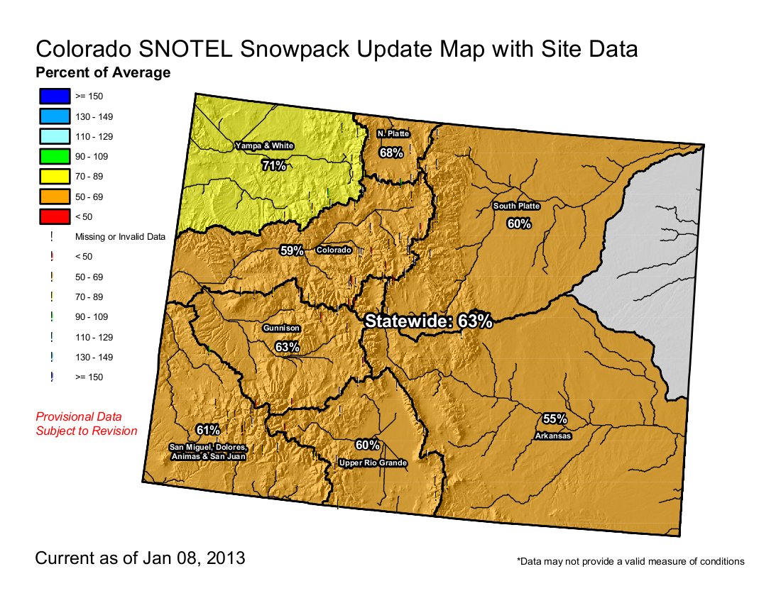
    Click on the thumbnail graphic for the table of January 1 snowpack and storage by basin and statewide.

    It’s interesting that while statewide snowpack is only 70% of average the Gunnison, Colorado and Yampa/White/North Platte basins are ahead of last year by a bit, 108%, 107% and 113% respectively. That just shows what a bad year 2012 was. Right now everyone is hoping that the snowfall trend of December will continue and that we don’t see a 2002 April or a 2012 March.

    Here’s the release from the Natural Resources Conservation Service (Mage Hultstrand):

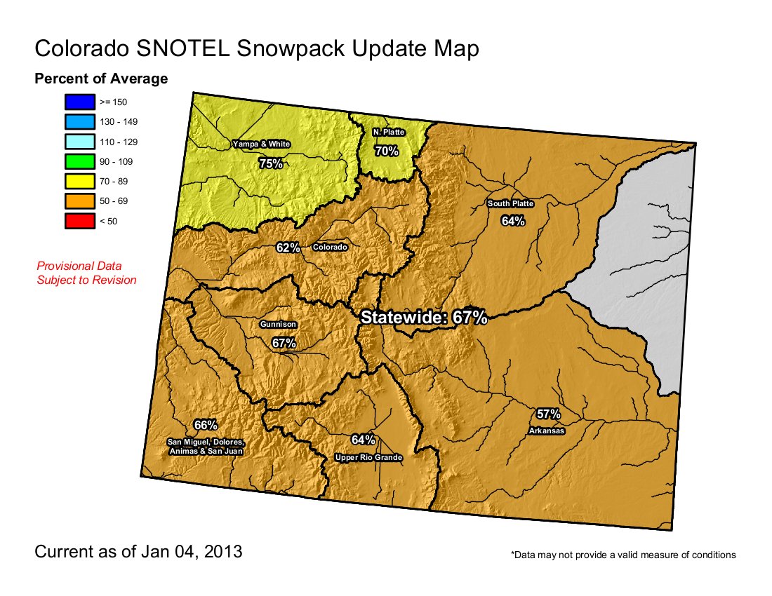
    The 2013 water year got off to a very slow start in the mountains of Colorado. As of January 1, Colorado’s statewide snowpack was 70 percent of average and 91 percent of last year’s readings, according to Phyllis Ann Philipps, State Conservationist, with the NRCS. “Conditions could have been much worse if we had not received the moisture we did in December” Philipps said. The much needed snowfall in December boosted the snowpack from just 36 percent of average recorded on December 1. Philipps also added that the January 1 snowpack is the fourth lowest within the last 32 years.

    Mountain precipitation was 112 percent of average for December but due to exceptionally dry conditions in October and November statewide total water year to date precipitation remains below average. In October and November, Colorado received only 50 and 41 percent of average precipitation respectively. Statewide year to date precipitation was at 68 percent of average as of January 1. Basins in southern Colorado have the greatest deficits. The San Miguel, Dolores, Animas and San Juan basins reported only 59 percent of average year to date precipitation on January 1. The Upper Rio Grande and Arkansas basins recorded 62 and 61 percent of average for year to date precipitation respectively.

    So far this winter season has been dominated by high pressure weather systems and a jet stream that has not cooperated. January 1 snow surveys confirm that snow accumulation is below average for this time of year across the state. Total accumulation ranges from 82 percent of average in the Yampa and White River basins, to 61 percent of average in the Arkansas basin. The South Platte River basin reported 67 percent of average and the Colorado River basin reported 68 percent of average

    Due to last spring’s well below average snowpack and subsequent low streamflow volumes throughout most of the state, reservoir storage is currently well below average throughout Colorado. Statewide reservoir storage at the end of December was just 68 percent of average and 38 percent of capacity.

    Here’s the latest monthly briefing from the good folks at the Western Water Assessment:

    Highlights

    December was generally wetter than average west of the Continental Divide, but mostly drier than average to the east

    Snowpack conditions improved in December but remain below-average across Colorado and in parts of Wyoming; snowpacks are near- or above-average in Utah and most of Wyoming

    The NOAA CPC climate outlooks now show a slight dry “tilt” for winter and early spring precipitation for the southern half of our region

    December Precipitation and Temperatures, and Current Drought

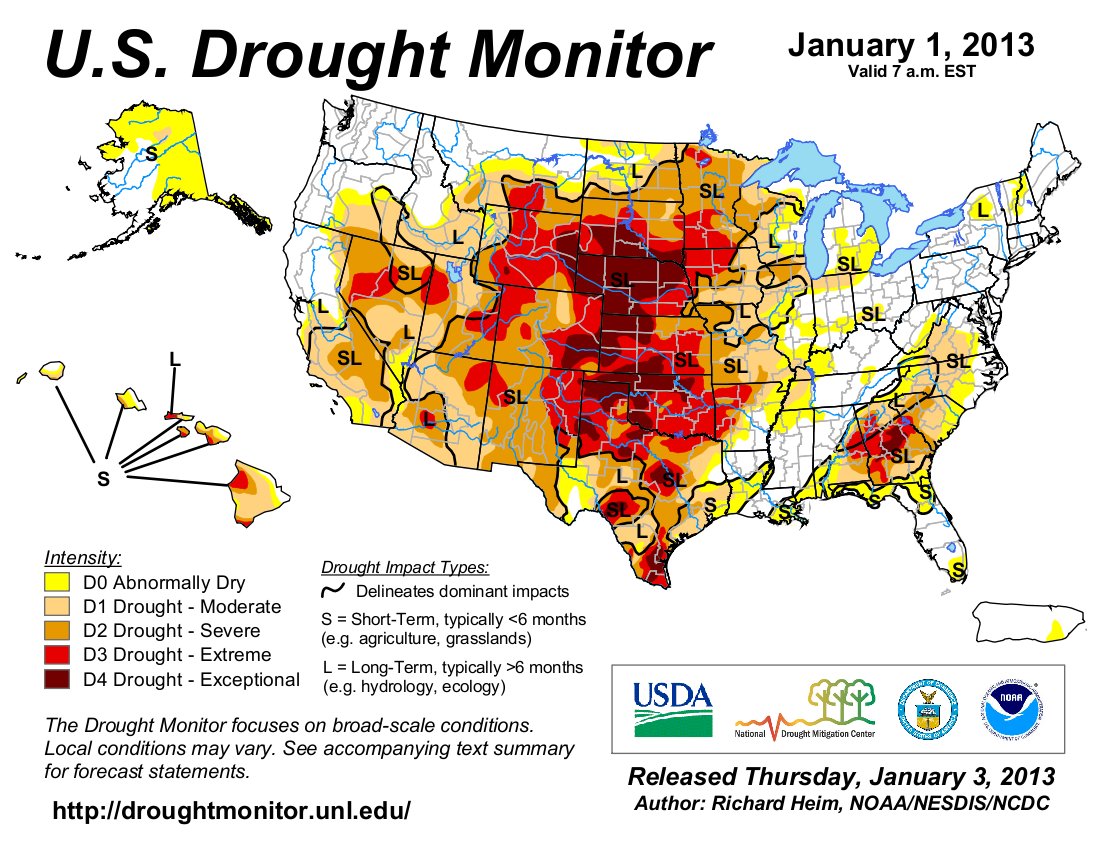
    December was wetter overall in our region than November and October, with most mountain regions seeing above-average precipitation for the month, including western and central Colorado, western Wyoming, and far northern Utah. There were also large areas with drier-than-average conditions, especially eastern Wyoming and most of eastern Colorado. Despite the December gains in many areas, the HPRCC Water Year Precipitation map shows that after the first quarter of the 2013 water year, nearly all of the region is drier than average, with some areas like southeastern Colorado seeing less than 50% of average October–December precipitation. December was cooler than average over most of the region, with the wetter areas generally seeing the below-average temperatures, and the drier parts of Wyoming and Utah being warmer than average. The latest US Drought Monitor, representing conditions as of January 1, shows a modest reduction in the area of severe (D2) and extreme (D3) drought conditions since late November, but the vast majority of the region is still classified in severe (D2) or worse drought: Colorado, 95%; Wyoming, 86%, and Utah, 66%.

    Current Snowpack and Streamflows

    As reported in the December 21 briefing, snowpacks across Colorado saw large gains in December. Even so, the NRCS Current Basin Snowpack map shows that Colorado—and southeastern and north-central Wyoming—still lag well behind average conditions for early January. In the rest of Wyoming and in Utah, snowpacks kept pace with normal accumulations during December and are near-average or slightly above average. The January 1 basinwide snowpack for the Upper Colorado River above Lake Powell was 86% of average, up sharply from 60% of average on December 1.

    In the maps of current streamflows in the three states, note that most gages are now ice-affected and not reporting, as is normal for this time of year. The gages that are reporting are mostly showing normal (green) streamflows, below-normal (yellow), or much-below normal (brown) flows for the date, with very few in the above-normal categories. The Colorado River near Cisco, UT gage, was in the 13th percentile, at 76% of the median flow for December 2.

    Seasonal Climate and Drought Forecasts

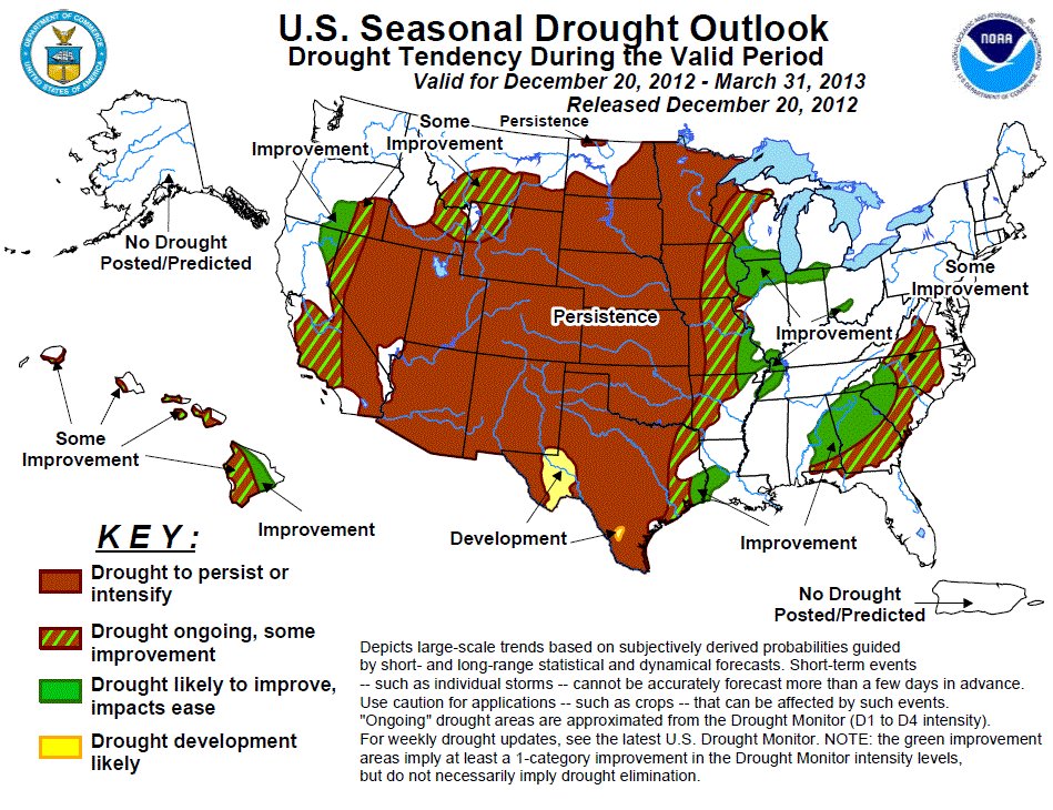
    As reported in the December 21 briefing, the latest monthly and seasonal Climate Outlooks released on December 20 by NOAA CPC are now showing a slight tilt towards drier-than-average conditions for the winter and early spring in the southern portion of our region. The IRI’s mid-December ENSO Prediction Plume shows a strong model consensus that ENSO-neutral conditions will continue through next spring, and only a slight chance of an El Niño or La Niña event emerging in that time frame. The CPC Climate Outlooks continue to show enhanced odds for above-normal temperatures for the winter and early spring season, consistent with the long-term trend towards warmer conditions. The latest CPC Seasonal Drought Outlook released January 3 once again projects that the drought conditions across our region will persist, through at least March 2013.

    From The Denver Post:

    As of Jan. 1, Colorado’s statewide snowpack was 70 percent of average — the fourth lowest snowpack in the last 32 years. But the numbers are a welcome increase after snowpack was recorded Dec. 1 at 36 percent of average, according to the news release from the conservation service.

    Mountain precipitation was 112 percent of average for December but dry conditions in October and November statewide have kept precipitation totals below average With below-average precipitation, the state’s reservoir storage also remains low. Statewide reservoir storage is at about 68 percent of average with the Rio Grande basin being the lowest, at 50 percent of average.

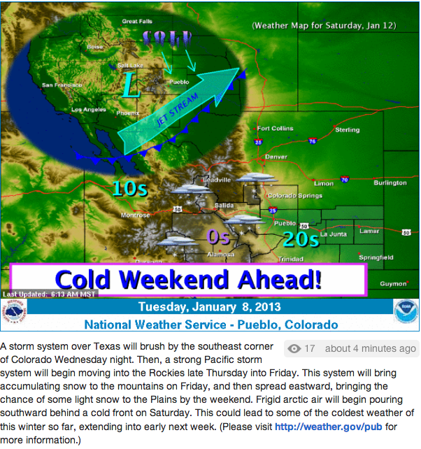
    The National Weather Service outlook for the month predicts close to normal precipitation for January, with the best chances for more snow in the middle of the month.

    From the Delta County Independent:

    Snowpack on Grand Mesa was gauged at 47 percent of average prior to the December storms, the Cedaredge trustees were told at their December meeting. Since the report, snow depth at Park Reservoir has increased from 37 inches on Dec. 12 to 45 inches on the day after Christmas, according to NRCS data.

    In addition, water storage reservoirs on Grand Mesa in the Surface Creek drainage have retained an estimated 15 percent-of-capacity carryover into the coming water year as of early December, reported the town public works department.

    The public works report, delivered to the Cedaredge Town Board on Dec. 13, compared that 15 percent figure with a 44 percent “basin-wide” average at this same time last year. Late December storms are improving the situation on the Grand Mesa. According to the NRCS data as of Dec. 28, the basin-wide average had improved to 67 percent of average.

    The Surface Creek drainage is still better off than some others, according to the report. Specifically, Young’s Creek is estimated to have a 7 percent carryover, the report stated. Data comes in part from state water officials.

    From The Greeley Tribune (Eric Brown):

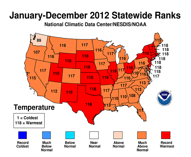
    Greeley’s weather statistics ended 2012 much the same way they spent the entire year — way too low in some regards and way too high in others. The year that just wrapped up stands as the hottest and driest year on record for the city. The 0.34 inches of precipitation Greeley received last month was nearly 40 percent less than average for December, according to figures provided by the Colorado Climate Center in Fort Collins. And Greeley’s precipitation total for all of 2012 stood at 8.33 inches — well short of the 14.69 inches the city receives on average annually. Falling short of the previous all­time low of 8.43 inches in 1968 means 2012 will go down in history as the driest on record.

    The average temperature for December was 31.6 degrees — nearly a degree above normal — and for 2012, the average temperature in the city was 55.3 degrees, 2.6 degrees above normal, and standing as the hottest on record. But as hot and dry as it’s been locally, the Greeley area is still faring better than the rest of the state. According to the most recent U.S. Drought Monitor from the U.S. Department of Agriculture, updated on Dec. 25, Greeley, western Weld County and some surrounding areas are experiencing “moderate” drought, while the rest of the state is enduring “severe,” “extreme” or “exceptional” drought.

    Conditions are the worst in southeast Colorado. The dry conditions across Colorado have created headaches for farmers and ranchers and water providers all year. Of particular concern to many this year is how dry it is in the mountains, although some progress has been made in recent weeks.

    Greeley, like many other cities in Colorado, is one that depends heavily on snowmelt from the mountains to meet its water needs. Weld County’s farmers and ranchers, too, depend on winter and spring snowpack to provide runoff that fills irrigations ditches during the growing season.

    At the end of last spring, snowpack across the state was just 2 percent of the historic average for that time of the year, according to numbers provided by the Natural Resources Conservation Service. But on Wednesday, snowpack across the state was 71 percent of its historic average for Jan. 2. In the South Platte River basin, snowpack stood at 70 percent of average, and snowpack in the Colorado River basin — where the northern Front Range also gets much of its water supplies — was at 68 percent of average. Of the eight major river basins in Colorado, the Arkansas River basin had the lowest snowpack numbers, with its levels at 59 percent of average on Wednesday.

    From the Fort Collins Coloradoan (Bobby Magill):

    For many Northern Coloradans, 2012’s searing heat and dry weather took a turn for the personal when the High Park Fire roared through Larimer County’s foothills. “To me, the story was personal and local, and it was awful. It was terrible,” said Colorado State University atmospheric science professor Scott Denning. “Everybody knows it. Whether it was climate change or not, it sure sucked.”[…]

    2012 was the most sweltering of years in Fort Collins, surpassing 2006 as the warmest year on record by nearly two degrees, according to Colorado Climate Center data. The year was only the 15th driest on record here, but coupled with the extraordinary heat, the year will become infamous for being on par with the most notorious drought years ever recorded here — 1934 and 1954, said Colorado State Climatologist Nolan Doesken. Scientists have long seen a warming trend in Colorado, but not until 2012 did the warming trend bring with it historic temperature extremes that challenged the heat records set in the 1930s and 1950s, he said.

    Fort Collins had three days of high temperatures above 100 degrees last summer, and Denver, Colorado Springs and Lamar all tied or broke their all-time heat records. The heat in Denver reached 105 degrees two days in a row — tying the all-time high set in 2005. Lamar hit 112 degrees…

    One of the most significant things about the 2012 drought was the lack of snow, said Don Day of DayWeather in Cheyenne. 2011 saw one of the most robust snowpacks in history here, with the water content of the snow in the South Platte Basin 142 percent of normal on Jan. 3, 2011. A year later, it was only 90 percent, dropping to about 60 percent by the beginning of April, 2012…

    Global weather patterns seem to be shaping up so that the coming months are sure to be wetter than last winter. “My opinion from what I’ve seen is that what we experienced in 2012 will not be repeated in 2013,” he said.

    From The Trinidad Times (Steve Block):

    Despite some recent snowfalls, persistent drought is likely to continue in much of Las Animas County through at least the end of January. State Climatologist Nolan Doesken said Wednesday that it’s hard to be optimistic about the near-term forecast for significant precipitation in this area.

    Doesken said that what little snowfall there has been in the Arkansas River Basin has not been enough to add to the area’s already severely depleted soil moisture. He added that the dry atmospheric conditions experienced in recent weeks tend to cause snow to evaporate into the atmosphere before it can soak into the soil. He said dry but cool conditions forecast over the next few weeks might help the area keep some of its thin snowpack, but could not predict any major weather events that would bring heavy snow…

    Doesken said the Front Range area of Colorado typically benefits from late winter and spring storms, but said it’s too early to predict major weather events with any certainty. He said the mid-Pacific Ocean weather currents known as “El Niño,” and “La Niña,” are also not very well defined this year.

    During winter weather seasons when El Niños and La Niñas are weak, storms across southern Colorado tend to be less intense and of shorter duration, according to the website crh.noaa.gov which offers an outlook on winter weather patterns. During winter months when weather patterns are weak, southeast Colorado tends to get normal to below average precipitation, and about normal to slightly higher temperatures, according to the website.

    Doesken said the two-year drought suffered by much of southern Colorado also impacts how much moisture the region needs to return to normal levels. “The Arkansas River Valley is way behind its normal moisture levels. So far, we haven’t had enough snow to add to the soil moisture.”[…]

    The central part of Las Animas County remained in a condition of Exceptional Drought, or D-4, at the end of 2012, the most severe drought category according to the website droughtmonitor.unl.edu. The eastern and western parts of the county were in the Exceptional Drought, or D-3, category at the end of 2012.

    Perry Stokes Regional Airport east of Trinidad reported about 4.5 inches of precipitation in 2012, according to the website of the High Plains Regional Climate Center at hprcc.unl.edu. The 30-year average for precipitation at the airport between 1971 and 2001 was about 14 inches per year.

    From the Summit County Citizens Voice (Bob Berwyn):

    December snowfall in Summit County was just slightly above average at both official observation sites, with Breckenridge weather watcher Rick Bly tallying 25. 3 inches for the month, just about 3 inches more than the average based on records going back more than 100 years. In Dillon, Denver Water observers reported 22.5 inches of snow in December. The average, based on records going back to 1909, is 17.5 inches. For the weather year to date in Breckenridge, Bly said he’s recorded 37.3 inches, which is 67 percent of the average 55.6 inches, and just barely ahead of last year’s 34.8 inches for the season. Weather watchers start their year on Oct. 1, in case you were wondering. While the snow total at Breckenridge may be shy of average, that snow melted down to about 4.31 inches of water, which, surprisingly, is just ahead of the seasonal average.

    January isn’t a particularly snowy month, but good things can happen. The all-time record January snowfall was 80.2 inches way back in the record-setting winter of 1899. But the second-snowiest January on record wasn’t all that long ago — 1996 brought 71.8 inches of the white stuff.

    Pueblo: The League of Women Voters are hosting a seminar about hydraulic fracturing Thursday

    fish-marcellushydraulicfracturing.jpg

    From The Pueblo Chieftain:

    A free public forum on hydraulic fracturing, or “fracking,” is set for 6 p.m. Thursday at the First Presbyterian Church, 200 W. 10th St.

    Jeff Chostner, the newly elected district attorney, will lead the conversation. Panelists include Chris Eisinger, a geologist, and Sara Landry of the oil and gas industry.

    The event is sponsored by the League of Women Voters.

    Next Middle Colorado River Watershed Partnership meeting January 16

    fish-presentation-flyer-full-page.jpg

    Click on the thumbnail graphic for the announcement. From email from the Middle Colorado River Watershed Partnership (Laurie Rink):

    Dear Watershed Enthusiasts –

    You are invited to attend our next Partners meeting on Wednesday, January 16th, 11:00 AM to 1:00 PM, at the offices of Colorado Parks and Wildlife, located at Canyon Creek and I-70 (Exit 109).

    On the agenda are two presentations (see the attached flyer or refer to the website):

  • “Healthy Rivers Sustain Rural Communities” – presented by Richard Gytenbeek of Colorado Trout Unlimited – linking healthy rivers to Colorado’s economy through agriculture, recreation, and tourism.
  • “Wild Things in the Watershed—All About Fish and Other Wildlife” by Lori Martin, Jenn Logan, and Kendall Bakich, Aquatic Biologists with Colorado Parks and Wildlife – recognizing the unique diversity of habitat in our watershed that fosters a host of fish species and other aquatic wildlife – what we know, what we don’t know, and what we would like to find out.
  • 2013 Colorado legislation: Sen. Gail Schwartz plans to introduce a bill to grease the conservation skids for farmers

    burlingtonditchheadgatehistoricalbdrc.jpg

    From The Aspen Daily News (Curtis Wackerle):

    As the legislative session is about to kick off, state Sen. Gail Schwartz, D-Snowmass Village, has drought and renewable energy on her mind.

    For her first bill of the 2013 session of the Colorado General Assembly, Schwartz will introduce legislation that would allow farmers to implement water-conservation measures without fear of endangering their water rights.

    The bill, which would enact safeguards against the normal “use it or lose it” rules governing Colorado water rights, was defeated in a summer water committee, where a supermajority is required to move forward. But in the normal session, Schwartz, who is the chair of the Senate’s Agriculture, Natural Resources and Energy Committee, would need just a majority to pass the bill. The idea, Schwartz said, is to protect farmers who choose to cut down on water use, since not taking the full allotment can expose water rights holders to abandonment claims.

    “Given the drought circumstances, we need to do things differently,” said Schwartz, 63, who is halfway through her second and final term as a state senator.

    More 2013 Colorado legislation coverage here.

    Drought news: ‘The drought and heat had their origins during the prior winter’ — AccuWeather.com #COdrought

    seasonaldroughtoutlook12202012to03312013.jpg

    usdroughtmonitor01012013.jpg

    From AccuWeather.com:

    The drought and heat had their origins during the prior winter. A fast storm track over northern Canada during the winter of 2011-2012 prevented cold air from making many visits into the U.S. and kept the frigid air locked up near the Arctic Circle.

    According to Expert Senior Meteorologist Brett Anderson, “This pattern, in turn, resulted in mild Pacific air over much of the U.S. and southern Canada. Additionally, a lack of snow cover over southern Canada then allowed any air coming southward to further warm up before entering the U.S.”

    The lack of cold air in the U.S. then greatly limited the intensity of storms during the winter and influenced the form of precipitation. Many stream and river systems are fed by the melting of snow cover and the release of frozen water in the ground through the spring and early summer.

    The warm start to the spring allowed some crops to be planted early in the Midwest. However, the soil also dried out very quickly. As the days lengthened and the angle of the sun increased, temperatures climbed much higher than average over the Midwest and occasionally spread into the East as a result of the dry landscape. Many cities over the middle of the nation had weeks of 100-degree temperatures.

    From Westword (Alan Prendergast):

    Drought contributes not only to wildfires but to the massive pine beetle epidemic that’s raged through the West for more than a decade, as detailed in last June’s feature “The Beetle and the Damage Done.” It’s hardly the only factor involved — warmer temperatures, the beetles’ accelerated reproduction cycle, decades of fire suppression policies, and other forces have contributed to the problem — but drought weakens the trees’ ability to fight off beetle invasions by oozing resin. And that means that, while the epidemic has slowed somewhat because it’s already devoured many of the lodgepole pines the beetles prefer, it doesn’t require that many beetles to take down a drought-weakened host.

    A healthier snowpack can help limit the beetle invasion, as well as reduce the fires that are altering the forests around the state. Forest officials are learning how to think long-term about the epidemic and its aftermath, planning for new forests that won’t have quite the vulnerability of our current trees, but that’s a solution decades in the making.

    From the Associated Press via the Soo Evening News:

    The federal government says preliminary figures show that Lakes Michigan and Huron reached record low water levels in December. Keith Kompoltowicz of the U.S. Army Corp of Engineers tells The Detroit News that the measurements are expected to be made official later in the week. All of the Great Lakes have had lower water levels in the past year because of light snowfall in the winter and light rainfall in the spring. The previous all-time low mean level was set in 1964 at 576.2 feet above sea level. The preliminary mean for December 2012 is 576.15 feet.

    From Reuters via Yahoo! News:

    In a seasonal outlook released Thursday [December 20], the Climate Prediction Center said extreme to exceptional drought was likely to persist across the Plains for the next three months. “Most of the annual rainfall for the High Plains really occurs in the springtime and early summer, so that is going to be the critical period. They really do need a wet season this year to make any kind of dent in the drought,” Miskus said…

    In its three-month outlook, the Climate Prediction Center said continued drought improvement is possible across the Midwest and in northern tier states including Minnesota, North Dakota and Montana…

    Drought conditions eased in the South after storms brought two to four inches of rain from eastern Texas to the Carolinas, the Drought Monitor report said. In Alabama, about one-third of the state remained in moderate to extreme drought but the rain eliminated the “exceptional” drought category that had covered about 3.7 percent of the state a week earlier. However, the report cautioned that long-term moisture deficits persisted in the region, and dry weather continued across much of western, central, and southern Texas.

    From the Grand Junction Free Press (Hannah Holm):

    A snowy December was the perfect Christmas present for a parched Colorado, which ended November suffering from desiccated soils, depleted reservoirs and anxious ski resorts. A series of storms over the past few weeks made the state start to look like its proper winter self.

    So the Drought of 2012 must be over, right? Not quite yet.

    The Weekly Climate, Water and Drought Assessment Summary for the Upper Colorado River Basin, released by the National Integrated Drought Information System (NIDIS) on Jan. 1, notes that the water picture improved markedly in December, but the amount of water in the snowpack in western Colorado river basins is still only between about 70% and 85% of normal for this time of year.

    The snowpack for the Upper Colorado River Basin as a whole (the area that drains into the Colorado River above Glenn Canyon dam) is doing better, at about 94% of average, because of higher accumulations in northeastern Utah and southwestern Wyoming river basins.

    The NIDIS report also notes that as of Dec. 30, soil moisture levels were below 30% of average across all of western Colorado and eastern Utah, with an exceptionally dry area in southwestern Wyoming.

    Looking more closely at the river basins that meet in Grand Junction, the Colorado River Basin snowpack in Colorado had 69% of its average water content for this time of year on Jan. 2. For some historical perspective, there’s more fluffy, frozen water in the hills now than there was at the beginning of 2012, and just about the same amount as at the beginning of 2002. The picture is similar in the Gunnison Basin…

    So, with all this data, what’s the take-home for western Colorado?

    It’s too early to panic about next year’s water situation, given that early spring is when we typically get most of our water, and large-scale, long-range projections aren’t terribly reliable for forecasting local conditions. But it’s also too early to breathe sighs of relief.

    The U.S. Senate approves $25 million for the Upper Colorado River Endangered Fish Recovery Program #COriver

    coloradopikeminnow.jpg

    From The Grand Junction Daily Sentinel (Gary Harmon):

    As the House and Senate wrangled over the fiscal cliff, Democrats and Republicans found agreement on the four endangered fish of the Colorado River. The Senate on Monday unanimously approved a measure reauthorizing the recovery program for four species of endangered fish in the Colorado River basin. Once it’s signed by President Barack Obama, the measure will remove a “significant uncertainty” for water users in the basin, said Chris Treese, spokesman for the Colorado River Water Conservation District.

    The recovery program allows for the continued development of the river and its tributaries for irrigation, storage and other uses with the cooperation of the U.S. Fish and Wildlife Service, state officials and other agencies.

    “This is milestone legislation that ensures western Colorado’s two endangered fish recovery programs continue to shield present and future water users from the worst consequences of the Endangered Species Act,” Treese said.

    Reauthorization clears the way for $25 million in spending on efforts to restore populations of the Colorado pikeminnow, razorback sucker, humpback chub and the bonytail. Extending the authorization for the Upper Colorado and San Juan fish recovery programs includes reforms to reduce overhead costs and eliminate inefficient agency spending to ensure the success of the programs while minimizing the taxpayer investment, U.S. Rep. Scott Tipton, R-Colo., a cosponsor of the measure, H.R. 6060, said in a statement. He also said he was “optimistic that these programs can reach their goals in the coming years, recover the species at issue, and safeguard the economic well-being of our communities and jobs connected to these efforts.”

    Sen. Mark Udall, D-Colo., said the measure, which he co-sponsored in the Senate, is “welcome news for Colorado’s rivers, wildlife, sportsmen and our economy.”

    Extending the recovery program will ensure that hundreds of water projects in Colorado and other Western states will remain in compliance with federal law, Udall said.

    The recovery program operates several facilities in the Grand Valley, including fish ladders on the Gunnison River south of Grand Junction and on the Colorado River in De Beque Canyon, recovery ponds in Horsethief Canyon and a fish passage at the mouth of De Beque Canyon.

    More endangered/threatened species coverage here.