
Cires has produced a YouTube video about a recent study that shows that dust on snow shorts the Colorado River Basin runoff and causes earlier runoff. Click here to view the video.

Cires has produced a YouTube video about a recent study that shows that dust on snow shorts the Colorado River Basin runoff and causes earlier runoff. Click here to view the video.

Water providers along the Front Range that rely on transmountain water from the Colorado River Basin are looking closely at the possibility of a future call on the river from the lower basin states as most transmountain diversions are junior in priority to the Colorado River Compact.
A recent study released by the Bureau of Reclamation predicts future supply shortfalls some 3.2 million acre-feet.
Southern Nevada is planning to mine groundwater in the Great Basin to bolster their supplies. For Colorado that might be a good thing since it should help decrease demand on suface supplies from the Colorado River.
On December 27 the Bureau of Land Management gave the go ahead for the 234 mile pipeline and collection system. Here’s their release:
The Bureau of Land Management (BLM) will publish a notice in the Federal Register on Friday, Dec. 28, announcing the availability of the Record of Decision (ROD) for the Southern Nevada Water Authority (SNWA) Clark, Lincoln, and White Pine Counties Groundwater Development Project. The notice is available on the Federal Register electronic desk on Thursday, Dec. 27. The purpose of the project is to construct a groundwater delivery system to the Las Vegas Valley.
The Lincoln County Conservation, Recreation and Development Act of 2004 (Public Law 108-424), directed the Secretary of the Interior to issue a right-of-way grant on Federal land in Lincoln and Clark counties, Nev., to construct a groundwater delivery system.
After extensive environmental analysis, consideration of public comments, and application of pertinent Federal laws and policies, the Department of the Interior has decided to grant the SNWA a right-of-way for the construction, operation, maintenance, and termination of the mainline water pipeline, main power lines, pump stations, regulating tanks, water treatment facility and other ancillary facilities of the project.
The decision authorizes the BLM to issue a right-of-way grant to the SNWA for the preferred alternative as analyzed in the Final Environmental Impact Statement issued in August 2012. The BLM will conduct subsequent environmental analyses for the future facilities and groundwater development.
The Nevada State Engineer is the authority for approving or denying water right applications. Up to 83,988 acre-feet per year (afy) of groundwater could be transported through the proposed facilities from the SNWA’s water rights in Spring, Delamar, Dry Lake, and Cave valleys, and up to 41,000 afy of water rights from the SNWA’s private ranches and agreements with Lincoln County. No water would be developed in Snake Valley.
The ROD, signed by Deputy Secretary of the Interior David Hayes, constitutes the final decision of the Department of the Interior. Any challenge to the decision must be brought in Federal district court.
Click here to go to the BLM webpage for the EIS. You can download a copy of the ROD there.
From the Associated Press (Sandra Chereb) via MSNBC.com:
“This is a huge milestone for southern Nevada,” said Patricia Mulroy, the water authority’s general manager. She said being able to “draw upon a portion of our own state’s renewable groundwater supplies reduces our dependence on the drought-prone Colorado River and provides a critical safety net.”
The Colorado River flows into Lake Mead, southern Nevada’s main water source. A recent study projected moderate to severe water shortages over the next several decades. Lake Mead’s surface level has dropped about 100 feet since 2000 because of ongoing drought and increasing demand from the seven states and more than 25 million people sharing Colorado River water rights. “What the study really told us was that we must prepare for a much drier future and that we can’t count on the Colorado River to sustain our community in the way it once did,” Mulroy said.
Environmentalists decried the decision, which comes two decades after the concept began to take shape and after years of litigation. More lawsuits are expected to follow.
Nevada’s state engineer, Jason King, granted the water authority permission in March to pump up to 84,000 acre-feet of groundwater a year from four rural valleys in Lincoln and White Pine counties. An acre-foot is the volume of water needed to cover an acre of land with water 12 inches deep — about 326,000 gallons. King’s rulings are being challenged in state court.
The pipeline approved by the BLM Thursday is needed to deliver that water to the southern Nevada’s population center.
Simeon Herskovits, an attorney in Taos, N.M., representing a coalition of ranchers, farmers, rural local governments and environmentalists, said the BLM decision was being reviewed but added that unless “serious deficiencies” in an earlier environmental study have been corrected, the decision to approve the pipeline cannot “be scientifically, economically or legally sound.”
The BLM’s decision follows findings made in November by the U.S. Fish and Wildlife Service that the project would not significantly affect about a dozen threatened or endangered species. Environmentalists say otherwise. “Some of Nevada’s rarest, most unique species rely on wetlands and springs,” said Rob Mrowka with the Center for Biological Diversity. “The Las Vegas water grab could undo all that and drive them extinct in the blink of any eye.”
BLM spokeswoman JoLynn Worley said the decision authorizes the “main conveyance and support facilities” to be built on federally owned land. It’s the last administrative ruling by the federal agency, and further challenges will be handled by the courts.
From Chance of Rain (Emily Green):
WHAT western water managers preach and what western water managers do is often contradictory. This much can be relied on: inconsistency starts at the top. Only this month a long-awaited report issued by the federal Bureau of Reclamation emphasized the need for conservation over big infrastructure projects. And we can trust its conclusions in that pointlessly hyped McGuffin projects such as diverting the Mississippi to the dry West or towing Alaskan icebergs to San Diego will not happen any time soon. However, only weeks after the release of the Colorado River Basin Water Supply and Demand Study, during the dead time between Christmas and New Year, Reclamation’s parent agency, the US Department of Interior, green-lighted the driving of a massive pipeline from Las Vegas hundreds of miles north into the Great Basin. This is the opposite of conservation over big infrastructure and its approval comes in spite of clearly devastating implications for thousands of square miles across the Great Basin.
Where, you might wonder, were our vaunted environmental regulations in all this? The short answer is that these laws and the agencies meant to enforce them are every bit as successful protecting our natural resources as the Securities and Exchange Commission is policing Wall Street. The Southern Nevada Water Authority deputy general manager who for many years fronted the Vegas pipeline once bragged to a local television reporter that she could get anything permitted. To judge by this week’s Record of Decision, she appears to be right. Watch enough projects go through environmental impact review and it’s hard not to conclude that this notionally protective scrutiny is nothing more than a line item on an infrastructure project budget. While reviews too rarely protect the environment, the expense turns out to be valuable to prospectors such as Las Vegas. Feigning diligence proves a useful inoculant against liability.
From the Las Vegas Review-Journal editorial staff:
Although the plan has been in the works ifor 25 years, congratulations may still be premature. Ms. Mulroy has little doubt more anti-development lawsuits are on the way.
In fact, the water authority would just as soon not build this project, which comes with a price tag variously estimated from $2 billion to $15 billion. Unfortunately, changing the law of the Colorado to allow interstate water purchases at market rates – the best solution – is still not politically feasible. Though certainly, if that day ever comes, it will help Nevada’s case to be able to say everything else has been tried.
From the Las Vegas Sun (Cy Ryan):
Initial briefs are scheduled to be filed Jan. 31 in lawsuits attempting to block the Southern Nevada Water Authority from building a pipeline to siphon water from Northern Nevada to Las Vegas.
The lawsuits seek to overturn a decision by state Engineer Jason King to allow pumping 83,988 acre feet of water a year from four rural Nevada valleys.
The Bureau of Land Management last week permitted the Water Authority to build the $15 million proposed pipeline on federal lands.
Scott Huntley, a spokesman for the authority, said a vote to start construction won’t be taken until conditions on the Colorado River dictate it. He said earlier that 90 percent of Southern Nevada’s water supply comes from the river, which is subject to drought.
The state Attorney General’s Office, which is defending the decision to allow the pipeline, says oral arguments in the lawsuits are scheduled for June 13-14 in District Court in Ely.
The suits say the pipeline will interfere with existing water rights and damage the environment.
From the Summit County Citizens Voice (Bob Berwyn):
The Southern Nevada Water Authority’s groundwater development project would siphon more than 27.4 billion gallons of groundwater per year from at least four valleys in central Nevada. According to environmental groups, the project would imperil dozens of species dependent on precious surface and groundwater in the driest state in the U.S.
“The federal government’s own scientists are confirming this Las Vegas water project would be an epic environmental disaster,” said Rob Mrowka, a Nevada-based ecologist with the Center for Biological Diversity.
“It’s really no exaggeration to say that the natural, cultural and social heritage of central Nevada is at grave risk from this project.”
Mrowka said the Center for Biological Diversity and other organizations will challenge the approval in court, claiming it violates the Endangered Species Act, the National Environmental Policy Act, Federal Land Policy and Management Act and Clean Air Act.
The BLM’s environmental study for the project discloses that more than 137,000 acres of wildlife habitat would be permanently destroyed or changed as the diversions lowers groundwater levels by up to 200 feet in some areas.
According to Mrowka, the loss of water will result in declines of species like mule deer, Rocky Mountain elk, sage grouse and Bonneville cutthroat trout. At most urgent risk will be species associated with the springs and wetlands that will dry up as the water beneath them is sucked away.
“Some of Nevada’s rarest, most unique species rely on wetlands and springs,” said Mrowka. “They’ve evolved over tens of thousands of years in response to isolation and fragmentation of habitat that occurred after ice ages. The Las Vegas water grab could undo all that and drive them extinct in the blink of an eye.”
Many of these species are often found in only one or two springs on Earth. As the springs are dewatered and flows are altered and eventually stopped, at least 25 species of Great Basin springsnails will be pushed to, or over, the brink of extinction. Also affected will be 14 species of desert fish, including the Moapa dace and White River springfish; frogs and toads will fare little better, with four species severely threatened by the dewatering.Other impacts from the project, disclosed in the BLM’s impact statement today, include ground-level subsidence in excess of five feet on more than 240 square miles, as well as tens of thousands of tons of new dust generated from de-watered and denuded lands.
Thanks to Coyote Gulch reader Kara for the heads up and the reminder that all the Colorado River Basin states have a stake in solving supply problems in the basin. As Wayne Aspinall famously said, “In the west, when you touch water, you touch everything.”
From the Fort Collins Coloradoan (Patrick Malone):
[State Representative Randy Fischer] will chair the House Committee on Agriculture, which is likely to be ground zero for natural resources legislation and forest health. The reach of local government to limit oil and gas development — including the practice of hydraulic fracturing — and efforts to diminish the likelihood of wildfires, could pass through the panel.
But Fischer hopes that the Colorado Oil and Gas Conservation Commission’s ongoing rule-making process will reconcile conflicts between communities and the oil and gas industry over well setbacks and air and water quality so lawmakers don’t have to…
Fischer’s first bill of the new session will seek to authorize graywater systems that reuse domestic wastewater as a means of conservation. He also plans to carry legislation aimed at addressing drought and water shortages.
More 2013 Colorado legislation coverage here.
NEW! Amusing Water Cycle diagram for Kids of all ages http://t.co/h4nBpz8d #teachers #FAOnews pic.twitter.com/ylldl1Tb
— USGS (@USGS) January 3, 2013
Because kids can never have too many tools to use when teaching adults.
More USGS coverage here.
From the Associated Press (Jim Suhr) via The Denver Post:
Despite getting some big storms last month, much of the U.S. is still desperate for relief from the nation’s longest dry spell in decades. And experts say it will take an absurd amount of snow to ease the woes of farmers and ranchers.
The same fears haunt firefighters, water utilities and many communities across the country.
Winter storms have dropped more than 15 inches of snow on parts of the Midwest and East in recent weeks. Climatologists say it would take at least 8 feet of snow — and probably far more — to return the soil to its predrought condition in time for spring planting. A foot of snow is roughly equal to an inch of water, depending on density…
In the West, firefighters worry that a lack of snow will leave forests and fields like tinder come spring, risking a repeat of the wildfires that burned about 9.2 million acres in 2012. Scores of cities that have enacted water restrictions are thinking about what they will do in 2013 if heavy snows and spring rains don’t materialize…
That’s why [Nebraska farmer, Tom Schwarz] is worried about his 750 acres near Lexington in south-central Nebraska. To save his corn last summer, he pulled water from deep wells and other sources in his irrigation district, but the alfalfa he couldn’t irrigate died — something he has never had happen before. The soil was so dry he didn’t even try to sow winter wheat, a crop that is planted in the fall and goes dormant over winter, relying on snow as a protective blanket.
“If we don’t get snow, we’d better get rain this spring, or we’re done,” Schwarz said.
From the La Junta Tribune-Democrat (Candace Krebs):
Colorado, Wyoming and Nebraska are all on track to record the driest year on record; the Midwest has been hit hard too. Climatologists at the National Drought Mitigation Center at the University of Nebraska have described this year’s drought as historically unusual in its speed of development, intensity and size. While a couple of recent winter storm systems brought welcomed snow to parts of the plains, going into 2013 it’s highly uncertain weather patterns will shift enough to improve range and crop conditions and replenish water deficits.
Well-known meteorologist Brian Bledsoe of KKTV in Colorado Springs is not optimistic. He gave what could only be described as a bah-humbug weather outlook during the Colorado Ag Classic. “Drought feeds on drought,” he said. “The longer it’s there, the worse it’s going to get.”
The eagerly anticipated El Nino weather pattern that began developing early in 2012 — expected to bring more moisture to dry regions of the country — instead turned out to be a scrooge, or what Bledsoe called “La Nada.”[…]
In addition, the current jet stream flow means fast-moving storm systems tend to skip over the High Plains before developing into more-organized storms further east. The last two snowstorms were textbook examples, moving through quickly and leaving marginal snow cover in many desperately dry areas.
Bledsoe ran through several medium-range climate models projecting a continuation of mostly dry weather through March. Spring could bring some relief to Oklahoma, Kansas and Nebraska, but prospects for Eastern Colorado were less encouraging. He called the April-May-June weather model for Colorado “horrific” and “really dry stuff.”
“It will be wet in the Midwest, Upper Plains and the Corn Belt,” he said. “In the summer, Kansas gets some moisture.”
High pressure will set up where the ground is hottest and driest, he added. That will make the Texas Panhandle “drought central” by next summer. Northern Colorado has the state’s best shot for getting some significant drought relief during that time period…
Longer term, the Pacific Ocean oscillation has shifted into a cold phase, which typically brings a dry trend to the High Plains as well.
“We’ve got another 20 years before it shifts out of this phase,” Bledsoe said. “Ranchers under 35 may want to look for a new line of work. We are reliving the ’50s right now. The parallels are unmistakable.”
As someone who runs a private meteorology consulting service advising farmers and ranchers in Colorado and surrounded states, Bledsoe added, “If you do not have a drought plan for your outfit, you better get one. Be prepared to capitalize on wet periods but realize it could be months before it comes back. Prepare for drought until we start getting regular moisture again.”[…]
Heavy snows across the Rockies are also helping to replenish the anemic winter snow pack, a key source of irrigation water for next spring. On the eastern side of the Rockies, the snow pack remains alarmingly low, half of normal in some cases.
From the National Weather Service Grand Junction office:
…GRAND JUNCTION EXPERIENCED A VERY WARM AND VERY DRY 2012…
IN 2012, THE AVERAGE TEMPERATURE IN GRAND JUNCTION WAS 55.2 DEGREES. THIS TIED FOR 3RD WARMEST EVER ON RECORD, DATING BACK TO 1893. THE WARMEST EVER WAS 57.5 DEGREES IN 1934.
THE AVERAGE MAXIMUM TEMPERATURE FOR THE YEAR WAS 69.2 DEGREES, WHICH IS 2ND WARMEST ON RECORD… WHILE THE AVERAGE MINIMUM TEMPERATURE WAS 41.1 DEGREES, THE 17TH WARMEST.
IN 2012, THE PRECIPITATION TOTAL FOR GRAND JUNCTION WAS 4.53 INCHES. THIS IS THE 3RD DRIEST ON RECORD. THE DRIEST EVER WAS 3.64 INCHES IN 1900.
The Colorado Foundation for Water Education plans to continue the blog they started for Colorado Water 2012. Here’s the announcment. Here’s an excerpt:
But let’s not get stuck reminiscing about the good old days. Many of the programs you loved in 2012 will continue into 2013– like this blog, it’s not going anywhere.
More Colorado Foundation for Water Education coverage here.

Here’s the ruling from the USFWS published in the Federal Register:
We, the U.S. Fish and Wildlife Service (Service), designate revised critical habitat for the southwestern willow flycatcher (Empidonax traillii extimus) (flycatcher) under the Endangered Species Act. In total, approximately 1,975 stream kilometers (1,227 stream miles) are being designated as critical habitat. These areas are designated as stream segments, with the lateral extent including the riparian areas and streams that occur within the 100-year floodplain or flood-prone areas encompassing a total area of approximately 84,569 hectares (208,973 acres). The critical habitat is located on a combination of Federal, State, tribal, and private lands in Inyo, Kern, Los Angeles, Riverside, Santa Barbara, San Bernardino, San Diego, and Ventura Counties in California; Clark, Lincoln, and Nye Counties in southern Nevada; Kane, San Juan, and Washington Counties in southern Utah; Alamosa, Conejos, Costilla, and La Plata Counties in southern Colorado [ed. emphasis mine]; Apache, Cochise, Gila, Graham, Greenlee, La Paz, Maricopa, Mohave, Pima, Pinal, Santa Cruz, and Yavapai Counties in Arizona; and Catron, Grant, Hidalgo, Mora, Rio Arriba, Socorro, Taos, and Valencia Counties in New Mexico. The effect of this regulation is to conserve the flycatcher’s habitat under the Endangered Species Act.
From the Summit County Citizens Voice (Bob Berwyn):
The designation covers about 208,000 acres of riparian habitat along 1,227 miles of rivers and streams in California, Arizona, New Mexico, Colorado, Utah and Nevada. Some of the critical habitat is along the banks of well-known rivers, including the Rio Grande, Gila, Virgin, Santa Ana and San Diego.
The flycatcher is a small, neotropical, migrant bird that breeds in streamside forests. It was first listed as endangered in 1995 in response to a petition from the Center for Biological Diversity.
“Protection of critical habitat for this tiny, unique bird could make a crucial difference to its survival, and also gives urgently needed help to the Southwest’s beleaguered rivers,” said Noah Greenwald, the Center’s endangered species director. “For all of us who love our desert rivers, this protection is great news.”
The USFWS initially designated 599 miles of riverside habitat in 1997 but was challenged by the New Mexico Cattle Growers’ Association. That led to a revised designation in 2007 that protected more stream miles.
But that was not enough to ensure recovery of the species, according to the Center for Biological Diversity, which challenged the rule, pointing out that it failed to consider hundreds of miles of rivers identified in a scientific recovery plan for the flycatcher.“Like so many desert plants and animals, southwestern willow flycatchers have suffered from the wanton destruction of rivers by livestock grazing, mining, urban sprawl and overuse,” Greenwald said. “We have to take better care of our rivers.
This week’s designation still excludes hundreds of miles of river habitat that was identified in 2011 plan. Greenwald said his organization will take a close look at these the exclusions to determine if the recovery of the flycatcher was properly considered.
From The Pueblo Chieftain (Matt Hildner):
Federal wildlife officials designated just over 9,000 acres in the San Luis Valley Tuesday as critical habitat for the southwestern willow flycatcher. While the move excluded all of the endangered bird’s habitat on private and stateowned land, it designated an 11.4 mile stretch of the Rio Grande through the Alamosa National Wildlife Refuge and another 12.7 mile segment that sits downstream under Bureau of Land Management jurisdiction.
The bird, which also received habitat protection from the U.S. Fish and Wildlife Service in five other southwestern states, makes its home in the dense streamside cover often provided by willows, cottonwood trees and tamarisk.
Mike Blenden, who oversees the Alamosa refuge for the service, said the designation would change little about how the refuge is operated but added that activities such as ditch cleaning and prescribed burning would involve more discussion with others in the agency.
Likewise, Denise Adamic, a BLM spokeswoman, said little would change for how the agency manages its land along the Rio Grande, save for a stricter consultation process with the service to comply with the Endangered Species Act.
The official rule designating the habitat said 11 miles on the Rio Grande and 64 miles on the Conejos River were excluded because of work by the Rio Grande Water Conservation District and other local governments to set up a conservation plan for the bird.
The ruling also noted that the flycatcher’s habitat had benefited from the establishment of conservation easements on nearly 9,000 acres of private land lining the Rio Grande and Conejos.
More endangered/threatened species coverage here.
Can ground water withdrawal make the land subside? Yes, more than 28 feet as documented by this amazing photo. pic.twitter.com/0F2EQTvV
— USGS (@USGS) January 2, 2013
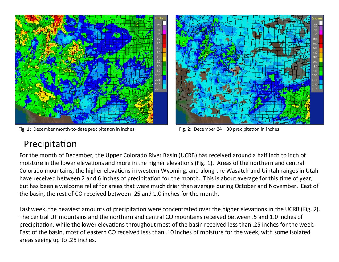
Click on the thumbnail graphic for the precipitation summary for this week. Click here to view all the summaries from the Colorado Climate Center.
From the Montrose Daily Press (Mike Easterling):
According to figures compiled by the National Weather Service in Grand Junction, unless the city gets significant precipitation over the final few days of 2012 — Thursday’s snowfall notwithstanding — this will be the driest year locally since at least 2000, and perhaps since 1989. In 2000, Montrose recorded 6.96 inches of precipitation. In 1989, it received 5.58 inches. Through the first 11 months of 2012, the city had drawn 6.34 inches of moisture, while December’s totals remained to be added. Unofficially, Montrose had recorded 0.27 inches of precipitation for the month through Wednesday, a total that was certain to grow with the arrival of Thursday’s storm.
From The Grand Junction Daily Sentinel (Dennis Webb):
As if it hadn’t been bad enough that one of Colorado’s worst droughts led to nearly 14,000 acres burning in the Pine Ridge Fire this summer outside De Beque, that same drought has hampered efforts to encourage important regrowth there.
Seeding with a temporary cover crop intended to stabilize soil at the fire site, prior to distributing native vegetation seed, failed to result in nearly the kind of germination hoped for by the Bureau of Land Management’s Grand Junction Field Office. There just wasn’t enough rain this summer for the temporary vegetation, marketed under the name QuickGuard, to take root, “which is amazing, because it generally doesn’t take much,” said Wayne Werkmeister, the office’s associate field manager. “That goes to show how truly bad it is out there,” he said.
The drought has made matters even worse for the field office because there were so many other big fires in Colorado this year that competition for reclamation money through the BLM’s fire funding program has been fierce. That meant the local office asked for less originally than it would have otherwise for the Pine Ridge Fire work, and ended up getting even a smaller amount. Nevertheless, officials are buoyed by recent snow on the fire site, and hoping the snow cover will last into early next year, when they hope to carry out aerial seeding of native plant mixes. “The more snow you have when you put it on up there, the better,” Werkmeister said. Beyond contributing to moisture, snow helps drive seed into the soil as it melts, and the seed also penetrates into the snow quickly, reducing consumption by birds and rodents, he said.
The Pine Ridge Fire, the biggest in history within the field office’s jurisdiction, burned in late June and early July. The danger presented by acreage denuded of vegetation was made almost immediately evident when a storm shortly after the fire deposited ash and debris into the Colorado River. That forced the Clifton Water District to shut down its river intake for a day and a half because it couldn’t remove the smoky color and odor from the water. A big flood coming off the burn area also could threaten the Union Pacific railroad tracks in De Beque Canyon. The BLM installed two gauges designed to help forewarn both Clifton Water and Union Pacific of further big storms, but the summer passed without further major incidents. “We dodged a bullet, so to speak,” said Dale Tooker, general manager of Clifton Water.
He said the utility supports the BLM’s revegetation efforts. Meanwhile, the fire helped revitalize the district’s planning for infrastructure upgrades that would include a membrane filtration system that would make problems such as ash runoff in the river a non-issue. Clifton Water is raising its rates starting next year as it prepares for such upgrades, which had been considered years ago but were put off by the recession.
Sagebrush and wildlife
Revegetation efforts at the fire site also are important to trying to minimize the spread of cheatgrass, an invasive, nonnative species that can dominate landscapes. It dries out early in the year, which can lead to even more fires and more cheatgrass. In addition, revegetation is important to wildlife, providing food and cover.
Fire can benefit wildlife habitat to some degree, leading to a more diverse landscape if it burns in mosaic patterns, as in the case of Pine Ridge Fire, which skipped over parts of the area within the burn perimeter. Still, there was loss of areas such as sagebrush parks that are important to deer and also have been eyed as potential habitat for the imperiled greater sage-grouse. Jim Dollerschell, a BLM rangeland management specialist, said sagebrush doesn’t resprout after a fire. This fall, crews tried to gather seeds from adjacent sagebrush parks and spread them in burned areas. “Unfortunately this year sagebrush seed was pretty sparse due to the drought,” he said.
The QuickGuard cover the agency spread consists of a sterile, annual plant, meaning it’s intended to immediately stabilize the soil but not reproduce and compete later with native plants. Its dead remnants also can provide cover from moisture-sucking wind and withering summer sun once native plants start to grow. It’s so receptive to a little moisture that some of it that spilled along the runway at the Garfield County Regional Airport, where it was raining lightly as crews took off to seed the fire site, germinated a few days later. But as of late in the year, many burn areas continued to look barren due to the meager growth of the plant. It could germinate this spring and still provide benefits. But Werkmeister said it also now will be growing along with the native perennials that will be planted by air this winter, and will likely outcompete them and hinder their growth if there’s not that much moisture. He’s hoping the spring will be wet enough for both the QuickGuard and native plants to thrive.
The seeds alone, consisting of species such as Indian ricegrass and bottlebrush squirreltail, cost the BLM almost $900,000. The BLM will apply three different mixes — one for areas of best growth potential, one for steeper, rockier slopes, and one for areas where there’s already a cheatgrass problem. That latter mix includes species that compete well with cheatgrass, including a nonnative species, tall wheatgrass.
Flooding concerns The field office had asked for $1.9 million for the fire rehabilitation work, but will end up with about $1.5 million. It had hoped to use some funds to build retention ponds designed to keep silt from reaching waterways in flooding, but wasn’t able to get that work started before Oct. 1, the start of the next federal fiscal year. Dollerschell said because there was so much fire activity going on around the West, funding wasn’t carried into the new fiscal year and the ponds won’t be built.
Existing ponds in the area did their job in catching sediment, though, without being breached or damaged, he said. “So it’ll be a focus for us in the next year or so to get those cleaned out so that their capacity is increased again,” he said. He said canyons in the area “have a lot of rock and armor in them, so if you do get some sediment runoff they’re going to capture a lot of that.”
Werkmeister said the field office didn’t get adequate funding to maintain the two storm warning gauges for the next two years, so it may be asking Clifton Water and Union Pacific for funding assistance.
Also, it was unable to get money to pay for seeding of forbs, plants particularly beneficial as browse for wildlife, because the BLM fire program had only enough funds to focus on seeds that primarily encourage watershed protection, Werkmeister said. However, Chevron and the National Wild Turkey Federation chipped in $10,000 apiece for forbs seeding. The High Lonesome Ranch, which had property burn in the fire and also is a grazing permittee in part of the fire area, has agreed to contribute the use of heavy equipment for some of the revegetation work.
Protected cactusThe area of the fire continues to be closed to all but specially approved uses, meaning activities such as hunting and recreational access aren’t allowed. “When you get a fire like that … in some areas it creates like a moonscape and it’s very enticing to individuals to do cross-country travel because there’s nothing there to stop them,” Dollerschell said. That can add to erosion and creation of new trails. The closure will aid in the revegetation work and provide protection to sensitive resources, such as the federally threatened Colorado hookless cactus. Seventeen of the plants are known to have burned in the fire.
If the drought continues into next year and seeds don’t germinate, that would be bad in the short term as far as trying to stabilize erosive slopes. But the seeds still could grow in following years.
The 2011 Cosgrove Fire, which burned some 1,700 acres near the Pine Ridge Fire, was reseeded by air last March. “Because it was so dry we had no seed germination or very little seed germination, which was probably a positive thing because if it would have germinated, the fact that April, May and June were so dry, even July, those seedlings would have fried, would have died,” Dollerschell said. That seed may germinate this spring, however. “We’ve found that that seed can sit in the soil, on top of the soil for three-plus years and we still get some response,” he said.
From The Greeley Tribune (William Trujillo):
The current drought conditions have many similarities to the conditions during the Dust Bowl of the 1930s. While soil management practices are better today, high temperatures and water shortages this past year created crop losses and poor environmental conditions that echoed the Dust Bowl.
The 2012 drought is the combination of a dry fall and high temperatures early in the spring. With the hotter than average temperatures in March, many plants began emerging earlier than usual. This premature start used up the little soil moisture that was available, setting the stage for severe water shortages later in the summer.
Even when rainfall might have been sufficient, evaporation and plant transpiration from the fields into the atmosphere were high due to the hot temperatures throughout the growing season.
Where crops failed or were damaged by drought, questions arise on how to manage similar conditions in the future. Variability associated with weather patterns makes crop management decisions difficult. With all of the soil water having been used this year to ward off drought conditions, it would take above normal precipitation to recharge the soils and get them ready for another growing season. What if the precipitation doesn’t come, are there management practices that will alleviate the conditions?
There are numerous options to manage soils, crops, animals, and water resources.
Conversion to notill combined with crop residue mulch and cover crops, is an important option. Under extreme conditions, crop losses were seen under notill. A positive environmental aspect is that even a small amount of standing biomass produced with notill will be an effective conservation practice in reducing wind erosion potential and preventing conditions that were seen in the 1930s Dust Bowl era. It is important that we prevent the negative effects of wind erosion with conservation practices. Crop residue with notill will reduce the evaporation rate, capture snow, and store precipitation in the coming months.
Another strategy is to conserve water in the root zone, minimize losses by runoff and evaporation, and transform blue (fresh surface and groundwater) and grey (urban wastewater) waters into green water (fraction of rainfall that is stored in the soil).
Integrated nutrient management, a judicious combination of chemical fertilizers with organic amendments (compost, biosolids), is needed to enhance soil organic matter content and maximize crop water use efficiency.
Ability of mineral soils to hold water increases with the increase in soil organic matter content. Thus, best management practices of land use and management should enhance soil and ecosystem resilience to drought and other abiotic and biotic stresses.
In addition, time of planting, seeding configuration and plant populations are appropriate agronomic considerations. Choice of crop species, depending on sitespecific considerations, is important to enhance crop diversity, including complex crop rotations, and integration of crops with livestock.
Vegetative barriers and terraces may enhance water storage, reduce the evapotranspirative stressor of wind, and minimize risks of wind erosion.
The drought has provided an opportunity to revisit agricultural systems of managing soils, crops, water, and animals. Are the current practices sustainable, especially under conditions of harsh, uncertain, and abruptly changing climate?
To avoid another “dust bowl” of the 1930s, it is the time to rethink how we use the natural resources. The drought of 2012 reminds us that soil and water resources must never be taken for granted.
From The Fort Morgan Times (Dan Barker):
Although many Morgan County farmers did OK despite the drought, cattle production is the foundation of the Morgan County economy — and it was hit hard last summer. The cost of hay jumped as high as $300 a ton, up from the usual $100 a ton. On top of that, since the drought hit just about every agricultural sector in every state, there was little alfalfa to ship in. Feed like corn and wheat had high costs, too. That meant some beef cattle producers had to sell off herds to avoid even more serious financial problems, and dairies’ production costs soared.
Dryland farmers were also hit hard. While dryland winter wheat growers seemed to dodge the bullet at the last minute with some rain in May, right after that was when the real drought hit. In addition, dryland corn growers had little success with their crops.
Nonetheless, irrigated farms did pretty well. The wheat crop was lower than last year, but not bad, and irrigated corn did well with all the sunshine it had. Crop prices held, which was a big help to crop producers, but not for cattle producers.
The federal government did offer emergency loans and allowed reserved conservation land to be used for pastures for cattle, but that only helped so much. A representative of the U.S. Department of Agriculture came to town to talk about what the feds could do, but said that was limited due to the national budget issues.
Lower local production could mean the local economy could suffer some.
One bright spot is that rain in the fall allowed the coming year’s winter wheat crop to germinate, giving it a head start for the new year.

From the Pine River Times:
Bayfield sewer rates will increase 5 percent starting in January. The town board approved the increase on Dec. 18. The additional money will be used to secure a $600,000 loan for sewer collection system repairs, according to Town Manager Chris La May.
The town’s sewer collection system experiences ground water infiltration during the spring and summer months. The groundwater level rises and infiltrates the system through weakened joints and cracks in the lines. Groundwater infiltration increases the hydraulic loading (total volume) at the sewage treatment plant, pushing the plant’s design capacity and negatively impacting the biological treatment process.
To address the infiltration, the town proposes to slip-line the main sewer collection lines rather than replace aging lines. Pipe lining would be completed with thermoformed or thermoplastic (PVC) pipe or cured-in place-pipe (CIPP). The liner material is rapidly pulled through the host pipe from manhole to manhole while the liner material is still flexible and then expanded and cured, generally through the application of steam, to form a hard, durable liner material. Pipe lining products conform to the interior of the host pipe so that there is no gap between the liner pipe and the host pipe. Services are then re-established remotely using a robotic cutter traveling inside the pipeline…
The 5 percent increase equates to an additional $2.10 per equivalent residential tap (ERT) per month and is expected to generate approximately $35,000 annually.
The town is concluding an extensive planning effort, which includes a survey of the existing collection systems, evaluation of collection system capacity for future growth, and identification of capital improvements necessary to accommodate growth. Upon completion of the planning effort, town staff will reevaluate the water and sewer rate structures to assure long term needs are addressed.
More infrastructure coverage here.

Here’s he release from the Environmental Protection Agency:
The U.S. Environmental Protection Agency (EPA) has updated the rule for pathogens in drinking water, including setting a limit for the bacteria E. coli to better protect public health.
The Revised Total Coliform Rule ensures that all of the approximately 155,000 public water systems in the United States, which provide drinking water to more than 310 million people, take steps to prevent exposure to pathogens like E. coli. Pathogens like E. coli can cause a variety of illnesses with symptoms such as acute abdominal discomfort or, in more extreme cases, kidney failure or hepatitis.
Under the revised rule, public drinking water systems are required to notify the public if a test exceeds the maximum contaminant level (MCL) for E. coli in drinking water. If E. coli or other indications of drinking water contamination are detected above a certain level, drinking water facilities must assess the system and fix potential sources and pathways of contamination. High-risk drinking water systems with a history of non-compliance must perform more frequent monitoring. The revised rule provides incentives for small drinking water systems that consistently meet certain measures of water quality and system performance.
Public water systems and the state and local agencies that oversee them must comply with the requirements of the Revised Total Coliform Rule beginning April 1, 2016. Until then, public water systems and primacy agencies must continue to comply with the 1989 version of the rule.
The Safe Drinking Water Act requires that EPA review each National Primary Drinking Water Regulation, such as the Total Coliform Rule, at least once every six years. The outcome of the review of the 1989 Total Coliform Rule determined that there was an opportunity to reduce implementation burden and improve rule effectiveness while at the same time increasing public health protection against pathogens in the drinking water distribution systems. EPA’s revised rule incorporates recommendations from a federal advisory committee comprised of a broad range of stakeholders and considers public comments received during a public comment period held in fall 2010.
For more information: http://water.epa.gov/lawsregs/rulesregs/sdwa/tcr/regulation.cfm
More Environmental Protection Agency coverage here.

Here’s the release from the Colorado Oil and Gas Conservation Commission (Todd Hartman):
State oil and gas regulators today [December 31, 2012] completed groundbreaking proposals for groundwater protection and the reduction of drilling impacts near homes for consideration next week before the nine-member Colorado Oil and Gas Conservation Commission.
The draft rules follow months of stakeholder meetings and public participation, including nearly a year of presentations and comment on the issue of how best to balance energy production with the need to minimize impacts on residences from nearby oil and gas development.
The two sets of rules were developed with extensive input from local governments, farmers and ranchers, the environmental community, homeowners, the energy industry, homebuilders, mineral owners, environmental health specialists and business leaders. COGCC staff has spent much of 2012 engaging these stakeholders in order to develop rules that protect the public health and environment while providing the flexibility needed to allow for production of energy that all Coloradans depend upon in everyday life, creates and sustains thousands of jobs and is critical to the state’s economy.
“These proposed rules reinforce Colorado’s role as a national pacesetter in the comprehensive and progressive regulation of oil and gas exploration and production,” said Matt Lepore, director of the COGCC, the state’s regulatory agency that staffs the Governor-appointed Commission. “These proposals contain mitigation standards unprecedented nationally and mark yet another step forward in fashioning a model regulatory framework that strikes a balance that’s right for Colorado.”
“At the same time, we understand that our draft rules will leave no one set of interests completely satisfied, and provide various targets for those who want to see it done differently,” Lepore said. “And yet, we expect most everyone who participated will see elements and concepts in these proposals that they helped initiate and push forward.”
Components of the proposals include:
The new rules will require operators to meet enhanced mitigation, notice and outreach requirements when drilling near residences beginning at 1,000 feet. Setbacks in previous rules of 350 feet (urban) and 150 feet (rural) will now be 500 feet statewide. New measures to limit impacts may include pit-less drilling, steel berms and underground liners, strict dust and lighting controls and capture of gasses to reduce odors and emissions. Operators must engage in expanded notice and outreach efforts with nearby residents and conduct additional engagement with local governments about proposed operations. Operators must conduct sampling of water wells near drilling sites both before and after drilling activities to ensure drinking water aquifers are protected. This would make Colorado the only state to require sampling both pre- and post-drilling. Operators cannot operate within 1,000 feet of buildings housing larger numbers of people, such as schools, nursing homes and hospitals without a hearing before the Commission. These proposals will be considered during public hearings scheduled for January 7, 8 and 9 before the Colorado Oil and Gas Conservation Commission. The Commission can modify the proposal, or pursue other options, based on testimony during this hearing, and in previous hearings that have taken place on these matters in recent weeks.
The upcoming hearings will take place at the Sheraton Denver Downtown Hotel, 1550 Court Place, beginning at 9 a.m. each day. The Commission includes representatives from across Colorado. Seats are filled by members with expertise in environmental and wildlife protection, agriculture, soil conservation, oil and gas production and regulatory oversight.
From the Fort Collins Coloradoan (Bobby Magill):
The Colorado Oil and Gas Conservation Commission on Monday unveiled its proposal for new oil and gas drilling rules that would mandate expanded setbacks and groundwater testing around new oil and gas wells. The commission will deliberate the rules during a three-day hearing Jan. 7-9 in Denver…
The proposed rules will not affect how closely homes can be built to existing oil and gas wells.
In a statement, COGCC director Matt Lepore said the rules make Colorado a “pacesetter” for oil and gas regulation, calling the rules “unprecedented nationally.”[…]
The Colorado Oil and Gas Association has long opposed increased setbacks. Last week, the group issued a statement opposing a 1,000 foot setback, which did not end up in the proposed rules.
The group claims new setbacks will cause greater environmental and economic damage to the region by pushing new oil and gas wells into undeveloped agricultural and open space lands.
COGA’s statement said increased setbacks will increase the cost of accessing oil and gas resources while reducing the amount of land available for farming, hurting farmers’ economic viability in coming years.
Northern Colorado environmental groups say the proposed rules don’t go far enough. Save the Poudre’s Gary Wockner, speaking for Clean Water Action and the Sierra Club, called the 500 foot setback rule “a farce,” and that oil and gas wells should be drilled no closer to buildings than 2,000 feet.
From The Grand Junction Daily Sentinel (Duffy Hayes):
As in 2009, when Colorado put in place the nation’s strictest rules regulating oil and gas extraction, the state appears poised to raise the regulatory bar once again with new, more-stringent rules. The Colorado Oil and Gas Conservation Commission — the state’s regulatory authority over energy development — on Monday released new draft rules that will be the focus of public hearings next week in Denver.
Among the proposed regulations: water sampling of wells before and after drilling activities, setbacks extended to 500 feet, exclusion from areas within 1,000 feet of schools and hospitals, and new community outreach requirements that drilling companies will be compelled to follow.
Enhanced mitigation by operators could be required as well. Those mitigation requirements were called “unprecedented nationally” and “mark yet another step forward in fashioning a model regulatory framework that strikes a balance that’s right for Colorado,” said COGCC director Matt Lepore in a press release.
Colorado in 2009 adopted groundbreaking regulatory rules, then the strictest in the nation. Since then, a number of states have enacted oil and gas rules that have exceeded Colorado’s in terms of strict controls. The new proposals were again called groundbreaking by the COGCC in terms of groundwater protection and the reduction of drilling impacts near people.
Last year, the COGCC agreed to re-open the details of the state’s regulatory framework, and held months of stakeholder meetings and presentations on the topic. The draft rules released Monday are the result of that process, COGCC said.
New setback requirements are central to the new proposed rules. Previous rules of 350 feet in urban areas and 150 feet in rural places would be extended to 500 feet. Operators will have to meet enhanced requirements for mitigation, notice and outreach to residents within 1,000 feet of drilling,as well. Also, drilling would be excluded from areas within 1,000 feet of buildings that house large numbers of people — such as schools, hospitals and nursing homes.
Further, Colorado would become the only state to require water testing both pre- and post-drilling, according to the proposed rules.
COGCC also said new measures “may include” strict dust and lighting controls, capture of gases, pit-less drilling, steel berms or underground liners.
The nine-member COGCC will hold public meetings on the new rules over three days, Jan. 7–9. The meetings will be held at the Sheraton Denver Downtown Hotel, beginning at 9 a.m. each day. The commission said that during those hearings, the group can modify the proposal, or even pursue other options, based on the testimony.
From the Longmont Times-Call (Scott Rochat) via the Boulder Daily Camera:
The hearings will begin at 9 a.m. Jan 7, 8 and 9 in the Sheraton Denver Downtown Hotel, 1550 Court Place…
The commission can adopt, alter or reject the proposed changes.
The discussion comes in the midst of a COGCC lawsuit against the city of Longmont, which adopted tougher regulations of its own. The city has maintained that its new rules are part of its traditional land use and zoning powers; the commission argued that Longmont was trespassing on the state’s authority to regulate oil and gas. Longmont’s rules include a restriction on any drilling in residential zones, and allow the city to require water-quality monitoring until five years after the well is abandoned. A contract between the city and TOP Operating, the main drilling company in the area, requires a 750-foot setback between well sites and occupied buildings.

Say hello to Conservation Colorado. Here’s the announcement from Pete Maysmith:
2013 – New Year – a new era for conservation in Colorado. Conservation Colorado makes its debut today. This is the beginning of an exciting, next chapter in protecting Colorado’s air, land, water and people.
Colorado is a place we are lucky to call home. Our stunning mountains, roaring rivers, clear blue skies, and spectacular landscapes make Colorado a fabulous place to live, work and play. Our mission is to protect the Colorado we love and the people who live here. My promise to you is that we will bring passion, energy, smarts, and an old fashioned “get it done” ethic to our work.
Take a look at our brand new website, ConservationCo.org, to get a sense of what we are going to be working on and how we plan to win.
Here’s the rub though – we can only succeed by working in partnership with you. Our strength and ability to win victories in the Legislature, the Congress, or with other key decision makers comes from our supporters, donors, activists, and allies.
That’s you.
In the coming months we will talk with you in the all the ways we know how to – via emails such as this, on Facebook and Twitter, at our events, and in one-on-one conversations.
We will advocate for our decision makers to finally tackle climate change, demand Congress and President Obama protect our last remaining wildlands, work to keep our rivers flowing free and deep, renew the state’s leadership in clean wind and solar power, and fight to minimize the impacts of oil and gas drilling.
Our work starts now. And we couldn’t be more excited to roll up our sleeves and get going. Look for a rollout of our legislative agenda soon and stay tuned for the latest developments on our wilderness and public lands campaigns.
In the meantime, poke around on our new website: ConservationCo.org. We love it and hope you will too. While you are there, take your first action with Conservation Colorado and tell Governor Hickenlooper that drilling and neighborhoods don’t mix and Colorado needs common sense safe guards to protect our air, water, and people.
Also, be sure to follow us on Twitter and like us on Facebook so you can get the latest information first and magnify your voice.
We could not be more excited about this new chapter in the conservation movement in Colorado. Thank you for all you do you for Colorado’s environment and quality of life. We look forward to forging many victories together in the months and years to come.
Because the Future is Worth the Fight.

It’s been snowing on and off for a good while now. December precipitation has been sufficient enough to bump snowpack across Colorado. Click on the thumbnail graphic for the Upper Colorado basin high/low graph from the Natural Resources Conservation Service. Upper Colorado snowpack = 70% of average for this date.
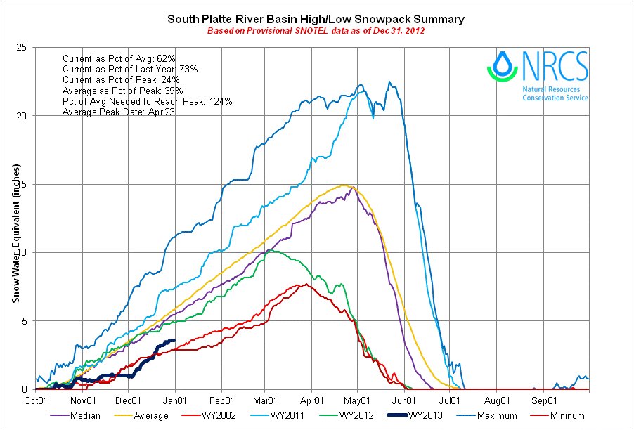
Click on the thumbnail graphic for the South Platte basin high/low graph from the Natural Resources Conservation Service. South Platte snowpack = 62% of average for this date.
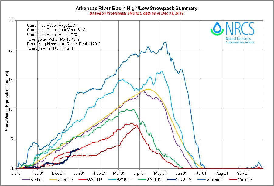
Click on the thumbnail graphic for the Arkansas basin high/low graph from the Natural Resources Conservation Service. Arkansas snowpack = 58% of average for this date.
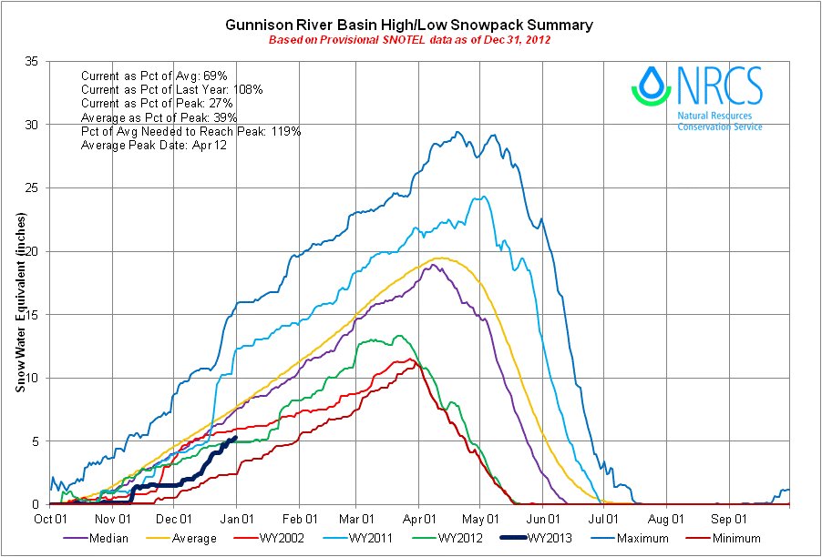
Click on the thumbnail graphic for the Gunnison basin high/low graph from the Natural Resources Conservation Service. Gunnison snowpack = 69% of average for this date.
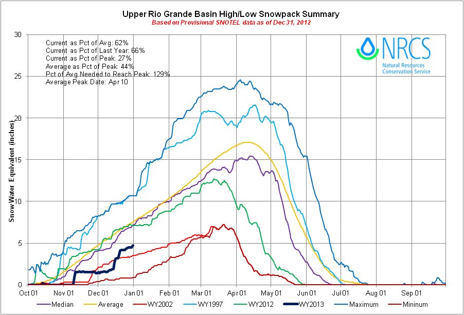
Click on the thumbnail graphic for the Rio Grande basin high/low graph from the Natural Resources Conservation Service. Rio Grande snowpack = 62% of average for this date.
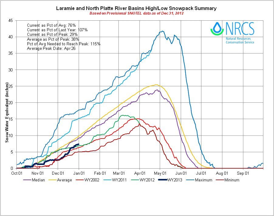
Click on the thumbnail graphic for the Laramie and North Platte basin high/low graph from the Natural Resources Conservation Service. Laramie and North Platte snowpack = 76% of average for this date.
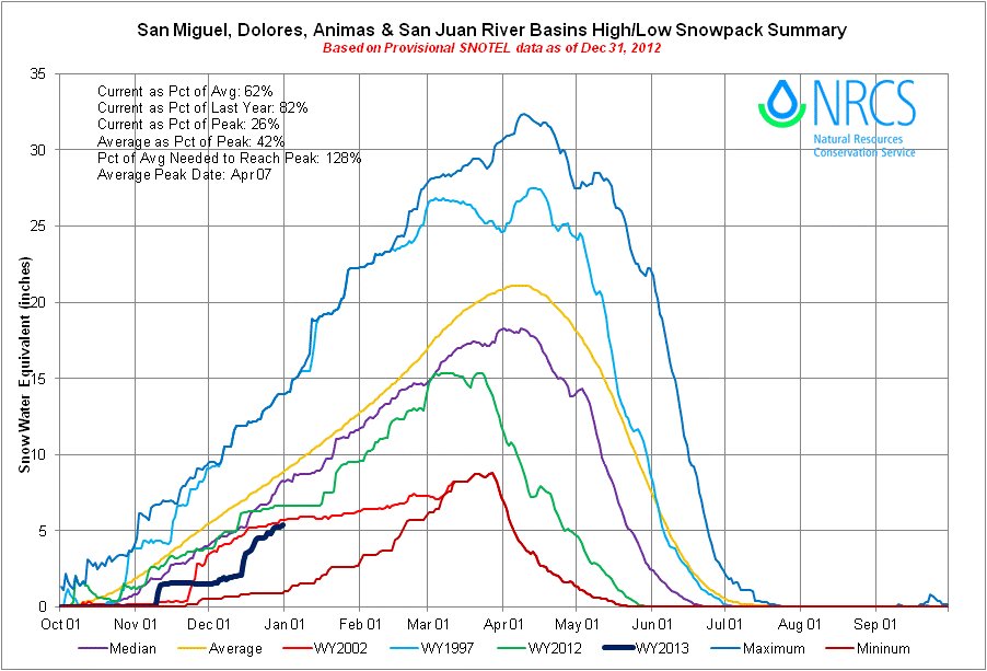
Click on the thumbnail graphic for the San Miguel, Dolores, Animas and San Juan basin high/low graph from the Natural Resources Conservation Service. San Miguel, Dolores, Animas and San Juan snowpack = 62% of average for this date.
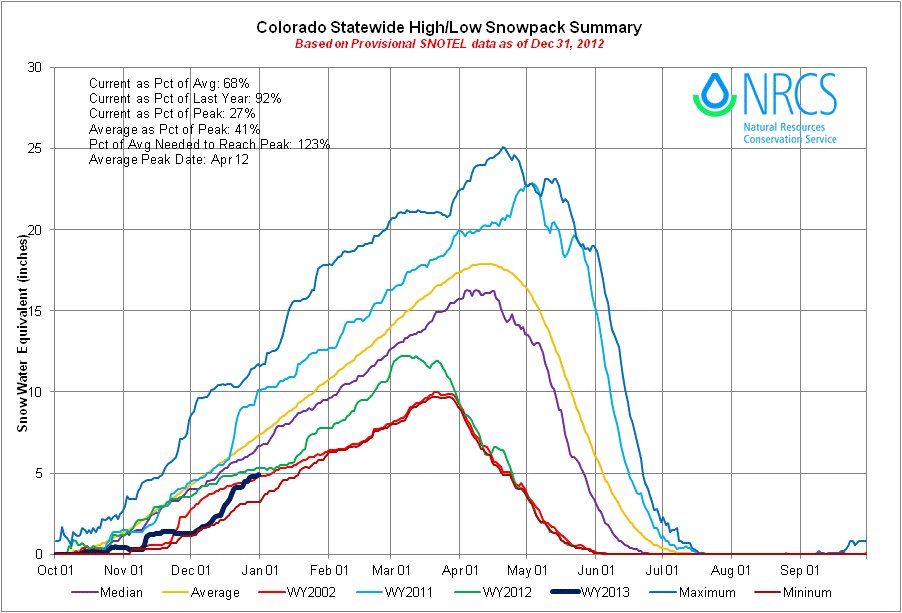
Click on the thumbnail graphic for the statewide basin high/low graph from the Natural Resources Conservation Service. Statewide snowpack = 68% of average for this date.
From the Boulder Daily Camera (Carol O’Meara):
“It’s a case of we don’t know what we don’t know,” says Russ Sands, City of Boulder’s Water Conservation Program Manager. “It’s way too early to say if we’ll have restrictions. If we have a few good storms, we won’t have to; everything is so dependent on late winter, early spring.”
Coming off of a record hot season, Sands says decisions Boulder made in 2012 to ramp up treatment plants and storage kept the city in good shape to meet needs heading into 2013…
Northern Colorado Water Conservancy District isn’t ready to push the panic button either, says Brian Werner, public information officer for the supplier of water to 33 cities and towns and 640,000 acres of farmland in northeast Colorado. “We’re always cautioning people to wait until March and April, because those are our wettest months.”
Werner acknowledges concerns, especially after last year’s low rainfall and this winter’s piffle of snow. After all, memories of the 2002 drought cast a shadow over the hearts of gardeners. “2012 was the second worst runoff year for us; you don’t want to put another year like that on top of it. But it’s followed three of the wettest years — 2009, 2010, and 2011. This is why we have water storage in this state.”
Yet storage is 25-percent below average in the district’s reservoirs, making the district cautious in its planning. “We have some big months (of moisture) ahead of us; Mother Nature’s given us that before. But with the way things are now, we’re casting a wary eye to the sky.”[…]
As one of the older cities in the region, Longmont has managed its water portfolio to ride out weather downturns like the current dry spell. Between its reservoirs and shares in the Colorado Big Thompson project, the city currently has plenty of water to meet needs for 2013.
“We track our water over a two year period and manage it conservatively, in case of dry year scenarios,” said Ken Huson, Water Resources Administrator with the city. “We project having 144-percent of need for 2013 and 136-percent for 2014. Our drought trigger is 135-percent or less, so right now we’re not projecting going into mandatory water restrictions.”
From The Washington Post (Brian K. Sullivan):
Forecast models suggest an area from parts of western Kansas south into Texas and west to New Mexico will probably see the drought continue until at least March, said David Unger, a meteorologist at the U.S. Climate Prediction Center in College Park, Maryland.
“The climate models have been quite consistent for below- normal precipitation amounts,” Unger said today in a conference call with reporters. He said he wasn’t confident about what will happen in other parts of the country, though there may be some relief in the Ohio Valley…
The drought reduced the corn harvest to the smallest in six years and sent prices up as much as 68 percent since June. The dry conditions also lowered the waters of the Ohio, Missouri and Mississippi rivers, shrinking shipping channels and crimping the flow of goods along the nation’s largest inland waterway, which carries more than 14.5 million tons of agriculture products, chemicals and coal.
Dryness is expected to persist through March from Nevada to western Missouri and from southern North Dakota to Texas, according to the prediction center.
Drought conditions now cover 61.79 percent of the 48 contiguous U.S. states and 51.7 percent of the entire country, including Puerto Rico, according to the U.S. Drought Monitor in Lincoln, Nebraska…
The drought is one of 11 natural disasters that cost more than $1 billion in 2012, said Adam Smith, an applied climatologist at the National Climatic Data Center in Asheville, North Carolina.
From KRDO.com:
While the additional snowfall has helped, Colorado Springs Utilities said it is not enough to bring the state out of the drought. “It has helped some, but we are still in drought, and so we’re still looking at a very dry year,” said Abby Ortega, Colorado Springs Utilities water rights administrative supervisor.
Ortega said reservoirs that serve Colorado Springs are at 49 percent of capacity, adding that ideally they should be at 75 percent of capacity.
According to Ortega, the mountains would need to receive several feet of snow to prevent water restrictions this spring. She said that while the forecast indicates below-average precipitation chances for the first couple of months, there is still a chance the season could take a turn for the better. “We’re not running out of time at all. Typically, Colorado sees most of our snowpack in March, April and sometimes even in May.