

Click on the thumbnail graphics for the April 24 statewide snowpack map along with the current US Drought Monitor and current drought forecast maps.
From the National Weather Service Pueblo office:
SINCE THE BEGINNING OF MARCH…PRECIPITATION TOTALS OVER NORTHERN AND CENTRAL PORTIONS OF THE STATE HAVE RANGED FROM 150 TO 200 PERCENT OF NORMAL. THIS COOL AND WET WEATHER PATTERN OVER THE PAST FEW MONTHS HAS ALLOWED FOR IMPROVEMENTS IN THE DROUGHT ACROSS THE CENTRAL MOUNTAINS AND PORTIONS OF THE UPPER ARKANSAS RIVER VALLEY. THIS WEATHER PATTERN…HOWEVER…DID NOT BRING MUCH PRECIPITATION TO WESTERN AND SOUTHEASTERN PORTIONS OF THE STATE…WITH PRECIPITATION TOTALS OVER THE PAST TWO MONTHS RANGING FROM 25 TO 50 PERCENT OF NORMAL ACROSS MOST OF THE REST OF SOUTH CENTRAL AND SOUTHEAST COLORADO.
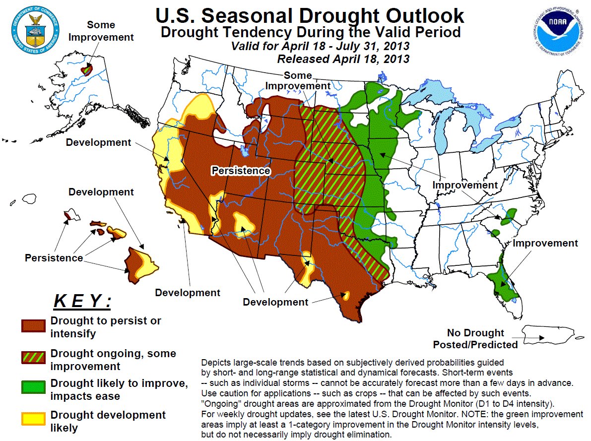
WITH THIS IN MIND…THE CURRENT US DROUGHT MONITOR NOW INDICATES MODERATE DROUGHT (D1) CONDITIONS ACROSS LAKE COUNTY AND WESTERN AND CENTRAL PORTIONS OF CHAFFEE COUNTY. THE LATEST US DROUGHT MONITOR ALSO INDICATES DROUGHT CONDITIONS DEEPENING ACROSS PORTIONS OF SOUTH CENTRAL AND SOUTHEAST COLORADO…WITH EXCEPTIONAL DROUGHT (D4) CONDITIONS INCREASING ACROSS NORTHEASTERN LAS ANIMAS COUNTY THROUGH NORTHERN BACA COUNTY. EXTREME DROUGHT (D3) CONDITIONS HAVE ALSO INCREASED TO INCLUDE SOUTHEASTERN LAS ANIMAS COUNTY AND SOUTHERN BACA COUNTY…WITH SEVERE DROUGHT (D2) CONDITIONS NOW INDICATED ACROSS ALL OF MINERAL COUNTY.
EXCEPTIONAL DROUGHT (D4) CONDITIONS REMAIN DEPICTED ACROSS SOUTHEAST EL PASO COUNTY…CENTRAL AND EASTERN PUEBLO COUNTY…EXTREME EASTERN HUERFANO COUNTY…CROWLEY COUNTY…OTERO COUNTY…KIOWA COUNTY…BENT COUNTY…PROWERS COUNTY AS WELL CENTRAL LAS ANIMAS COUNTY.
EXTREME DROUGHT (D3) CONDITIONS CONTINUE TO BE INDICATED ACROSS NORTH CENTRAL THROUGH SOUTHEASTERN FREMONT COUNTY…SOUTHWESTERN THROUGH EAST CENTRAL TELLER COUNTY AND MOST OF THE REST OF PUEBLO AND EL PASO COUNTIES. EXTREME DROUGHT (D3) CONDITIONS ALSO REMAIN INDICATED ACROSS EASTERN HUERFANO COUNTY AND WESTERN LAS ANIMAS COUNTY.
SEVERE DROUGHT (D2) CONDITIONS CONTINUE TO BE DEPICTED ACROSS THE REST OF SOUTH CENTRAL AND SOUTHEAST COLORADO…NAMELY THE REST OF CHAFFEE…FREMONT…TELLER…EL PASO…PUEBLO AND HUERFANO COUNTIES…AS WELL AS CUSTER COUNTY…SAGUACHE COUNTY…RIO GRANDE COUNTY…CONEJOS COUNTY…ALAMOSA COUNTY AND COSTILLA COUNTY.
MORE INFORMATION ON THE US DROUGHT MONITOR CLASSIFICATION SCHEME CAN BE FOUND AT: WWW.DROUGHTMONITOR.UNL.EDU/CLASSIFY.HTM
SUMMARY OF IMPACTS…
THE DROUGHT HAS IMPACTED SOUTH CENTRAL AND SOUTHEAST COLORADO IN MANY WAYS…INCLUDING INCREASED WILDFIRE ACTIVITY AND DANGER…FAILED AND POOR YIELD ON NON IRRIGATED CROPS…CATTLE LOSS AND ABANDONMENT…AS WELL AS QUESTIONS ON WATER AVAILABILITY AND WATER RIGHTS.
THE LATEST COLORADO WATER AVAILABILITY TASK FORCE REPORT INDICATES MANY MUNICIPALITIES ARE ACTIVELY PREPARING TO RESPOND TO CONTINUED DROUGHT CONDITIONS. WITH THIS IN MIND…THE TWO BIGGEST WATER UTILITIES IN THE STATE…DENVER WATER AND COLORADO SPRINGS UTILITIES…HAVE IMPLEMENTED STAGE 2 DROUGHT DECLARATIONS AS OF APRIL 1ST…REQUIRING MANDATORY RESTRICTIONS ON LAWN IRRIGATION…HOTEL LAUNDRY…CAR WASHING AND OTHER NONESSENTIAL WATER USES THROUGHOUT THE SPRING AND SUMMER DEMAND SEASON.
From KRDO (Michelle San Miguel) via The Pueblo Chieftain:
Farmers are beginning to plant Pueblo chiles, but they say they’re going to have to sacrifice other crops to make sure the water they do have is enough to grow the famous chile.
Shane Milberger, owner of Milberger Farms, grows 50 types of vegetables. None, he says, is more important than Pueblo chile. “Just look around, I mean everything has to do with Pueblo and Pueblo chile. It’s like Rocky Ford and cantaloupe. They go hand in hand,” Milberger said.
Milberger is making do with 60 percent less water than what he had last year. After the state pulled water from his wells, his only source is the Bessemer irrigation ditch. “We’ve been in the droughts before but this in my opinion, this is the worst one I’ve seen,” he said.
Growing season is just getting started but restaurants, like Sunset Inn, are already preparing for prices to go up. Bill Chavez, a cook at Sunset Inn, says the owner orders more than 90 bushels of chiles every year. “Last year it went up $2 a bushel and since the drought was kinda bad last year and it’s worst this year,” Chavez added, “I’m sure it’s gotta go up.”
If restaurants do have to raise their prices, that won’t stop customers, like John Walker, from paying more. “It’s so good,” he said.
“If all of us farmers out here could raise a good crop and maybe get a bumper crop, I would think that the price would be the same as last year,” Milberger said. “If we get any bad weather on any one farmer out here, then expect for the prices to possibly go up.” As a result of the drought, Milberger is growing 30 acres of chiles this year, compared to the 50 acres he grew last year.
From the Boulder Daily Camera (Mitchell Byars) via The Denver Post:
Boulder has been hit with a record 47.6 inches of snow in April, and the snow hasn’t been limited to the Front Range. Mage Hultstrand, assistant snow survey supervisor for the Natural Resources Conservation Service, said the state didn’t reach the peak snowpack level — when the snowpack is at its highest before snowmelt sets in — until Monday. That peak normally comes much earlier in the month. “It typically occurs in early April,” Hultstrand said. “It looked like we were going to have an early peak at the end of March, but the big storms the last few weeks really boosted this snow pack…
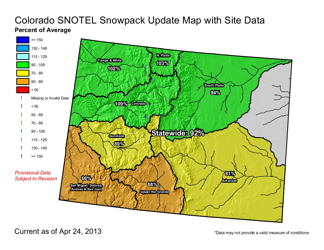
The snowpack in the South Platte River basin — a major water supplier for the Front Range — is 95 percent of normal for this time of year, according to the Natural Resources Conservation Service website. As recently as April 7, it was 70 percent. The basin’s peak snowpack was 90 percent of the typical peak. The upper Colorado River basin snowpack level is now 109 percent of average for this time of year, up from 74 percent April 7. The peak snowpack was 95 percent of the typical peak.
From The Fairplay Flume (Mike Potter):
Travis Thompson, a spokesman for Denver Water, told The Flume Thursday morning that the decision came late Wednesday to halt the plan to remove fish from the reservoir and to move the water to Eleven Mile Reservoir and Cheesman Reservoir. That means Antero Reservoir, a popular fishing and recreation spot in Park County, will remain open this summer…
Thompson said when the decision to close Antero was announced in early March, Denver Water’s weather predictions showed poor chances for additional snow to help boost a flagging snowpack that helps feed Antero Reservoir. “Even though these are usually wet months, the amount of snow that we received wasn’t projected in the forecast,” he said.
Dave Bennett, a water resource manager for Denver Water, said it’s always difficult to project what kind of moisture will be available. “Managing water supplies through a drought is an ever-changing process,” he said in a press release. “While we are still in drought and need our customers to save water, the recent snow has helped our supply situation. Keeping Antero open will be a benefit to Park County and those who love to fish there. If we drained the reservoir, it would take about three years to refill.”
From The Grand Junction Daily Sentinel (Dennis Webb):
On average, Colorado gets only about 8 percent of its seasonal snowpack in April. This April, “we blew (that) out of the water, which is kind of what we needed to do,” said Mage Hultstrand, assistant snow survey supervisor with the Natural Resources Conservation Service in Colorado.
It wasn’t enough to end the drought. And it didn’t share the wealth equally across the state. But the recent moisture that fell in late-season storms in good parts of the state’s high country significantly improved conditions that continued to look dire as recently as the start of the month.
“That’s been very welcome news,” said Eric Kuhn, general manager of the Colorado River Water Conservation District in Glenwood Springs. As of late last week, the rain gauge at his Glenwood-area house had recorded about 4 inches of moisture for the month, more precipitation there than in all of October through March, he said. Recent storms have resulted in substantial snowpack improvement in the Upper Colorado River Basin and improved the outlook for Grand Valley irrigators. Unfortunately, conditions remain a fair amount drier in more southern basins within the state, he said. Some of those basins have snowpack levels that are about two-thirds of normal. Still, the statewide snowpack made a considerable comeback in a mere matter of weeks. Snow accumulations were abysmal last October and November. An above-average December improved things a little, but the statewide median was stuck in the low-70 percentiles from Jan. 1 through April 1.
Today, it’s at 92 percent.
“We received well above average snowfall and accumulation in April, which is what we needed, and which we thought was highly unlikely,” Hultstrand said.
Dennis Phillips, a meteorologist for the National Weather Service in Grand Junction, said he can’t emphasize enough how good it was to get the two major storms that hit the state this month. “I think everybody’s going to be pretty happy, but we’re still in drought conditions,” he added. “It takes a long time to get into a drought and it takes a long time to get out.”
Water-watchers universally are welcoming the recent moisture in measured tones. “We’re still in the same wait-and-see mode,” said David Reinertsen, assistant manager of the Clifton Water District, which relies on Colorado River Water stored upstream in Green Mountain Reservoir near Kremmling. “These added snowstorms have definitely helped the upper mountain snowpack and water equivalency but we’re nowhere near where we are in a bumper year.”
Colorado suffered through a low snowpack season a year ago, but that followed plentiful precipitation in the 2010-11 season that had left reservoirs full and able to ease the impact. With many reservoir levels more depleted now, that cushion no longer exists.
Clifton Water and some other water utilities in the Grand Valley continue to ask customers for voluntary water conservation now, in hopes that mandatory restrictions can be avoided.
Denver Water, a major user of Colorado River water, imposed twice-a-week watering and other restrictions at the start of April. “Obviously, we’re grateful for this snow, it’s been a huge help,” said Jim Lochhead, the agency’s manager and chief executive officer. “But we’re still planning on dry conditions for the summer. We really don’t know how this will all work out until we see how our reservoirs end up filling.”
While the improved snowpack levels are encouraging, some caveats also need to be applied to the statistics. For one thing, Hultstrand notes that the NRCS switched this year to a new 30-year period against which it compares current levels. That period, from 1981-2010, was drier than the last comparative period, which included the wetter 1970s. So a snowpack that’s at 100 percent of the current median is less than 100 percent of the past measure. Also, current snowpack is being compared to levels that in most years already have begun to shrink by now, which Hultstrand said can be a little misleading. Another way to look at the current amounts is to compare them to median peak levels. By that measure, the Upper Colorado River Basin as of Wednesday was at 95 percent of the peak median, versus 109 percent of the median for April 24. The Gunnison basin is at 76 percent of peak, versus of 89 percent of median for April 24. Statewide, snowpack is at 80 percent of the median peak, Hultstrand said.
Yet another complication involves some recent dust storms that have darkened snowpack in much of western Colorado. That can result in snowpack melting off much more quickly, Phillips noted. That’s due to dark-colored snow reflecting less sun and absorbing more. But the impact can at least be delayed if more snow has fallen on top of it.
For now, anyway, the start of the runoff season has been delayed by cool temperatures, which also have minimized use of irrigation water to date. Temperatures are expected to go up in coming days, but Reinertsen said the delay in irrigating helps let reservoirs build up their storage. This year’s delayed runoff stands in stark contrast to last year, when the already-meager snowpack started melting in March. A year ago on Wednesday, the Upper Colorado River Basin snowpack was just 37 percent of median for that date. Phillips said last year the snow-water-equivalent in that basin probably peaked at around 11 inches and was down to five or six inches by this point in April. This year it’s above 14 inches and has yet to even start melting, he said.
David Boyd, a local Bureau of Land Management spokesman, said the spring moisture “has helped quite a bit” in terms of moderating the fire danger this year. But he added, “Predictions now are for an average fire year in this area, but that is still several hundred fires with the potential for large fires. The lower-elevation desert areas received some moisture, which will lead to more green-up and growth of fine fuels like grasses. As the weather warms, those grasses will cure and be fuel for wildfires if there is an ignition source.”
This winter’s snow pattern was unusual but not entirely unexpected by some. Back in November, meteorologist Joe Ramey, Phillips’ coworker, said the winter was shaping up to be a “No Niño” winter, as opposed to an El Niño or La Niña one. He was referring to varying climate patterns dictated by equatorial eastern Pacific Ocean water temperatures. No Niño winters, meaning ones that show either La Niña or El Niño tendencies, are tough ones in terms of predicting snowfall, he said. But he pointed out that the four previous No Niños in Colorado were characterized by stormy Decembers and Aprils with drier periods between them. It turns out, December 2012 and this month both produced above-average precipitation. Ramey “hit that one pretty well,” Phillips said.
Told of Ramey’s November comments, Hultstrand said, “He should get a raise, I guess.”
Review for Snowy April 2013 in Utah and Colorado (UPDATE): youtu.be/Z5w7F8R6bXQ?a via @youtube
— NWS Grand Junction (@NWSGJT) April 25, 2013