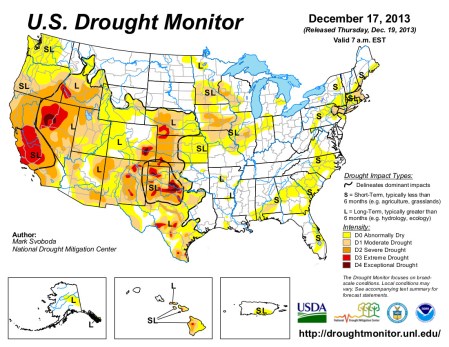
Click here to go to the US Drought Monitor website. Here’s an excerpt:
The Central and Northern Plains and Midwest
After some modest improvements last week, most locales in these regions saw little in the way of precipitation over the past week, leading to few or no changes in the depiction on this week’s map. The one area that did see some minor expansion of drought this week was in central Kansas, where the recent warm, windy and dry weather has led to a slight push eastward of D1 conditions…
The South and Southern Plains
Last week was rather cool and dry for most parts of these regions as the drought keeps its grip and begins to swell again across parts of southern Texas and western Oklahoma and the panhandles of both states. Scattered pockets of increases and/or introductions of D1/D3 are noted in both states given the continued dryness of late on top of long-term (12- to 36-months) dryness, which has left behind dry stock ponds and slowed winter wheat and pasture growth/recovery…
The West
Drought and dryness continued its march northward to the Canadian border through coastal and central Oregon and Washington this week as dismal water year numbers continue to roll in. Widespread expansion of D0 is noted in both central Oregon and Washington while D1 has now spread across the southwestern corner of Oregon up to the Umpqua Divide. In fact, many locations in southern/southwestern Oregon (around the Medford and Klamath Falls areas) are approaching record dry calendar years. Groundwater levels for wells are of increasing concern in these areas of the state, and the ski resorts (many not even open yet) are feeling the brunt of it as well given the lack of snow to date. According to the National Weather Service in Medford, OR, Mount Shasta City may epitomize the impacts: current 2013 calendar year precipitation stood at 9.99 inches as of earlier this week, and the 1981-2010 normal stands at 43.21 inches. In fact, December of 2012 was wetter (10.43 inches) than all of 2013 to date.
Region wide, early USDA-NRCS SNOTEL readings are abysmal for both Water-Year-to-Date precipitation and snow water equivalent with values as of December 17 falling in the 30-50% of normal range. There is plenty of time to make it up in January-March, but this certainly isn’t the start to the season many were hoping for.
Although there are no changes to the map in California this week with D2/D3 firmly entrenched across 83% of the state, impacts are beginning to really ramp up, with the Big Sur fire and water supply issues a continual concern and making plenty of news heading into 2014. Indeed, fire has become more than just a seasonal concern for those folks in California of late. The NWS office in Los Angeles/Oxnard reported on December 16 that Los Angeles is on track for its driest calendar year on record with data going back to 1877. Through December 15, LA had recorded only 3.49 inches (26% of normal). The current record dry calendar years of 1947 and 1953 both came in at 4.08 inches. Many other locations around the region are approaching similar dubious record or near-record dry calendar years…
Looking Ahead
During the December 19-23, 2013, time period, a system is expected to bring some much-needed moisture to the Pacific Northwest. Additionally, heavy rains are expected across portions of the eastern southern Plains and into the middle Mississippi Valley and Ohio Valley. Others along the eastern Seaboard and up into New England can also expect to share in some of the moisture, although at more modest levels. Above-normal to well-above-normal temperatures are expected across northern California, Texas and the Gulf Coast region and from Florida northward into New England. Cold air looks to remain entrenched across the central and northern Plains along with the western Great Lakes region.
For the ensuing 5 days (December 24-28, 2013), warmer temperatures are anticipated across all of Alaska, California and the southern Atlantic Coast region from Florida up to the coastal Carolinas. Cooler temperatures are expected in the Pacific Northwest, Intermountain West, Mississippi Valley and Midwest, including the Great Lakes. Dryness seems to be in the cards for most, with below-normal precipitation likely across most of the West, central and southern Plains, Mississippi Valley and western Gulf Coast states. Alaska and the southern Atlantic Coast states can expect above-normal amounts of the wet stuff, though.
