
Click here to go to the US Drought Monitor website. Here’s an excerpt:
Summary
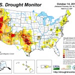
In a repeat of last week, yet another large weather system moved across the country’s midsection, bringing copious rains to the central Plains, middle Mississippi Valley and the Tennessee Valley, with 3-6 inches being a regular occurrence. Parts of the Pacific Northwest also enjoyed some nice moisture during the week. As for temperatures, most of the West and South saw well above normal temperatures, with readings 6 to 12 degrees above the norm. Unseasonably cooler weather was confined mostly to the northern and central Plains along with the Upper Midwest and Great Lakes regions…The Plains and Midwest
On the heels of large areas of heavy rains last week across the region, another storm dumped another round of heavy rains (2 to 6 inches) across the state of Missouri, eastern and southern Kansas, western and southern Arkansas, eastern Oklahoma and northeastern Texas. Large 1- to 2-category improvements are noted in the D0-D2 areas on this week’s map for those areas seeing the heaviest rains and deficits being erased back to six months or more in those areas listed above. Soil moisture and streamflows are in great shape heading into winter in these areas as well. Missouri saw large improvements, with all but a small remnant of D0 being all that remains in the southwest part of the state where D1 was last week. Drought has been removed in northwest Arkansas, but the dryness persists and has expanded ever so slightly in the northeast corner of the state. Texas was more of a mixed bag, with rains improving things by 1 category in the eastern portion of the state (in general), but warm and dry conditions leading to degradation, with expansion of D1-D3 sneaking back in across south Texas. North-central Texas has also fared a bit better of late, and this is reflected in a slight trimming of D2-D4 in this part of the state and along the Red River border with Oklahoma.Farther north, the rains missed the northern Plains (with no complaints or major impacts being reported as harvesting efforts are well underway now and behind schedule), with just a slight expansion of D0 showing up in southeastern North Dakota. To the east in Wisconsin, a good late period soaking led to the removal of the D0 across the southwestern quadrant of the state…
The West
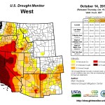
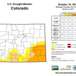
High temps and dryness continue to plague much of the West during the early weeks of the new Water Year, with the exceptions being southern Colorado, southeast Arizona and the eastern third of Washington in the Cascade Range and along the coastal ranges. This trend has led to an expansion of D1 across more of northeastern Oregon.One area that has done really well the past 6 months, and even tracking back to the beginning of the calendar year, has been in eastern Idaho, parts of northern Utah and northern Nevada. This has led to some early Water Year reassessment, noted by the trimming and shifting of D0-D2 westward in eastern Idaho and through a change of the impact line from “S/L” to “L”. As we enter the new Water Year, there are still some long-term lingering water supply issues across this region and into southwestern Montana, which bears watching to see if this wet pattern carries on during the winter.
The recent run of wetness this fall has led to some favorable soil moisture recharge and improving conditions in southern Colorado, with the removal of D3 and some reduction of D0-D2 noted there on this week’s map…
Looking Ahead
For the period October 15-20, after seeing a very wet pattern the past few weeks across the country’s mid-section, there should finally be some time to dry out and let the harvesting resume. The only areas showing good chances for heavier precipitation are in the coastal ranges and mountains in the Pacific Northwest, primarily from northern Oregon up into Canada. The other area expecting good rains is from the Mid-Atlantic up into New England, where 1-3 inches should bring some relief to the region. As for temperatures, most of the West, Pacific Northwest and the Great Plains states are expecting to see unseasonably warm temperatures, with readings likely running 3-6 degrees above-normal.Looking at the 6- to 10-day time frame (October 21-25), the warm temperature trend continues into this period, and the entire western two-thirds of the country and most of Alaska are expected to see above-normal temperatures, with the strongest likelihood falling in the High Plains and along the Rocky Front Range from Colorado and Wyoming up into Montana. The bulls-eye for cooler than normal weather is found in the Tennessee and Ohio Valleys and within the Mid-Atlantic from Georgia northward into New Jersey. A greater likelihood of above-normal precipitation over this period is confined to the Pacific Northwest, Four Corners, southern Florida and the New England coastline. However, a large area of the country from the Great Plains eastward into the Mississippi Valley, the Midwest, Ohio Valley, Tennessee Valley and the western fringes of the Mid-Atlantic can expect it to be dry, with the highest probability falling from the Great Lakes down to the Gulf Coast along the Mississippi Valley.