Federal Historic Preservation Act can complicate water projects

Orchard Mesa circa 1911

From The Grand Junction Daily Sentinel (Gary Harmon):

Miles of ditches throughout much of the Grand Valley north of the Colorado River will get a once-over in the coming months as the Grand Valley Drainage District surveys its network of drains and canals.

The cultural-resources survey was prompted by the experience the district had early this year when a contractor wanted to install a pipe across a drain more than 50 years old that was maintained by the district.

“This started in January,” said district Manager Kevin Williams. “We did not get the permit until July.”

It took that long for the district to obtain a permit under the federal Historic Preservation Act for the job from the U.S. Army Corps of Engineers, Williams said.

With that experience in mind, the drainage district put together plans for the cultural-resource survey that officials hope to use to reach a programmatic agreement with the Corps of Engineers, Williams said.

Once that happens, the district can move more quickly on public or private projects affecting the district’s facilities, Williams said, rather than undertake expensive and lengthy examinations of individual proposals.

The study itself is to be financed by a $50,000 grant from the Mesa County Federal Mineral Lease District and it will be conducted by Dominguez Archaeological Research Group.

Dominguez also will work with the state Historic Preservation Office, which is to sign off on the study.

“We just tried to be a little proactive,” said Williams, who called the requirement that every proposed crossing of the drainage system be studied for its historical implications an example of “constant overreach” by regulatory agencies.

Officials hope to complete the survey in a year and then begin negotiations with the Army Corps of Engineers.

“We have close to 200 miles of open drains that we’re trying to get inventoried,” Williams said.

The drainage district might be only the first Grand Valley agency to conduct such an inventory.

The Orchard Mesa Irrigation District also has some 200 miles of drains and ditches built about the same time the drainage district’s network was constructed, Williams said.

More Colorado River Basin coverage here.

Southeastern Colorado Water Conservancy District 2015 budget update

Pueblo dam releases
Pueblo dam releases

From The Pueblo Chieftain (Chris Woodka):

The Southeastern Colorado Water Conservancy District board is expected to approve a $17.9 million budget at its next meeting, 11 a.m. Dec. 4.

The district last week reviewed the details of the budget and hosted a public hearing. No member of the public attended.

A mill levy of 0.94 mills is planned, the same as 2014. One mill is an assessment of $1 for every $1,000 of assessed valuation. The district covers parts of nine counties, including Chaffee, Fremont, Pueblo, El Paso, Crowley, Otero, Bent, Prowers and Kiowa.

The district also makes money through sales of water and grants.

More than $12 million will go toward repayment of the Fryingpan-Arkansas Project, including the Fountain Valley Conduit. The conduit serves El Paso County communities that pay a dedicated mill levy on top of the district mill levy.

The district will spend $2.34 million for its own operating expenses, and $3.5 million on enterprise, or business, activity.

Included in the enterprise fund are the Arkansas Valley Conduit, and an ongoing project to develop hydroelectric power at Pueblo Dam.

More Southeastern Colorado Water Conservancy District coverage here.

A call for conservation — The Pueblo Chieftain #COWaterPlan

watersprinkler

From The Pueblo Chieftain (Chris Woodka):

Environmental groups see a new direction for Colorado water development based on comments on the state water plan in the past year.

“We heard loud and clear from the comments from people all over the state that conservation is needed,” said Bart Miller, water program director for Western Resource Advocates. “We’re hoping the plan will be even stronger on this point in the final form.”

Conservation groups are pushing a fourpronged program that embraces stretching current water supplies rather than developing new sources.

  • Keeping rivers healthy and flowing.
  • Increasing urban efficiency and conservation.
  • Modernizing agricultural and water sharing programs.
  • Avoiding new large transmountain diversions.
  • For years Western Resource Advocates and allied groups have rejected calls for new supply and more storage, saying wiser use of resources is needed. A statewide poll taken in September shows support among Colorado voters for those goals, with 88 percent saying cities should reduce water use by 10 percent by 2020. That mirrors many comments in the state water plan that say reducing urban usage of water is a key way to stretch resources.

    “It ties in with the governor’s executive order that talked about smart urban growth,” Miller said. “There are some opportunities to encourage better development in the future.” The need for the water plan grew out of the realization during the drought of 2002 that state water providers needed to accommodate a growing population without the traditional buy-anddry of agricultural land.

    There were also comments about the state water plan that urge caution in relying too heavily on urban conservation as a strategy. Those pointed out how cities already are using up to 20 percent less water per capita than a decade ago, and warn against “hardening” demand so that restrictions would be necessary in the next drought. There also would be problems with a statewide edict on how growth and water development occur, since those decisions are now primarily made at the local level.

    “The state has the ability to help with technical resources and funding,” Miller said. “One of the things people want to see is more transparency on the part of large providers.”

    More Colorado Water Plan coverage here.

    EPA Waters of the US rulemaking: Colorado Corn Growers Association speaks out

    Crop circles -- irrigated agriculture
    Crop circles — irrigated agriculture

    From the Colorado Corn Growers Association via the High Plains/Midwest Ag Journal:

    Leaders with the Colorado Corn Growers Association recently submitted comments to the U.S. Environmental Protection Agency, voicing concerns about the EPA and U.S. Army Corps of Engineers’ proposed Waters of the U.S. rule. CCGA leaders stressed they believe the intentions of federal officials in their WOTUS rule-making efforts (clarifying protection under the Clean Water Act) are wildly different from what the outcome will actually be (an expanded jurisdiction of the EPA).

    Below is a portion of the letter submitted to the EPA by CCGA President Dave Eckhardt:

    “As president of the Colorado Corn Growers Association, I agree whole-heartedly with many of the points made by our National Corn Growers Association leaders in the letters they’ve sent you regarding this rule. Like them, I believe this unprecedented increase in jurisdiction must not be finalized without first undergoing significant revision. I also agree there is tremendous uncertainty we face because of the way the rule defines what is ‘tributary,’ and what is ‘adjacent.’ And it concerns me as well that a vast number of ditches are or could be subject to federal jurisdiction, and if these or other waters like them on my farm are made jurisdictional, I fear I would face serious risk of lawsuits.

    “But my concerns and those of so many others here in Colorado go beyond that, largely because of our unique water situation, and our local rules and restrictions that are so different here than in other places across the U.S. That is the point I want to stress above all others; I find it impossible that the EPA can create a one-size-fits-all set of rules for everyone, when, just to provide one very basic example, places like the Midwest need systems and rules in place to divert excess water off their fields, while we in Colorado and across the West require infrastructure and regulations to divert limited water on to our fields. There are just so few consistencies region-to-region when it comes to water functions, making it incredibly difficult to create something that works for everybody.”

    Eckhardt—who, in May, hosted a gathering of EPA officials at his farm in LaSalle, Colorado, to discuss this proposed rule—also noted in his letter it isn’t just farmers in the state who are concerned. Municipalities and many other non-ag water officials across Colorado have also voiced their dire concerns about how this would impact our complex water system and unique set of local regulations.

    Leaders with the National Corn Growers Association—as well as ag organizations and other groups across the U.S.—have also weighed in.

    “We appreciate efforts to bring greater clarity and certainty to the understanding of what are waters of the U.S. Unfortunately, this proposed rule provides neither,” said NCGA President Chip Bowling. “This rule will adversely impact more than 300,000 corn farmers. As it is currently written, the financial and practical consequences for farmers are unacceptable.”

    Bowling emphasized that NCGA has and will continue to work with the EPA to create a fair and workable rule. In October, Bowling, too, hosted nearly a dozen EPA staffers at his southern Maryland farm, part of a series of meetings between NCGA and the Agency on WOTUS.

    “Farmers are proud of their conservation efforts and are committed to protecting and restoring water quality,” said Bowling. “We have and will continue to work with federal and state agencies and other organizations that care about water quality.”

    More Environmental Protection Agency coverage here.

    Cooperative water agreement signed with Colorado, Kansas and Nebraska — High Plains/Midwest Ag Journal

    Republican River Basin by District
    Republican River Basin by District

    From the High Plains/Midwest Ag Journal:

    Reflecting a new spirit of cooperation, Colorado, Kansas and Nebraska recently have reached an historic agreement during a special meeting of the Republican River Compact Administration. Representatives of the states have signed a resolution, approving operational adjustments in 2014 and 2015 under the Republican River Compact that will benefit water users throughout the Basin and set the administration on a course to find long-term solutions to persistent problems.

    Chairman Brian Dunnigan, Nebraska Director of the Department of Natural Resources, cited recent comments by U.S. Supreme Court Special Master William J. Kayatta, who encouraged the states to work toward greater consensus for administering the waters of the Basin. “It is in that spirit that the states have negotiated the resolution that was approved today,” said Chairman Dunnigan.

    The signed agreement addresses the operational adjustments address how water is administered for the benefit of irrigators in the Basin. It provides Nebraska with 100 percent credit for water delivered from augmentation projects to Harlan County Lake prior to June 1, 2015, and the delivered water is for exclusive use by Kansas irrigators.

    The agreement is in addition to two cooperative agreements signed in October. Together, these three agreements change the traditional ways the compact has been previously interpreted and implemented for a more cooperative approach.

    Kansas Commissioner David Barfield acknowledged the new resolution comes on the heels of another mutually acceptable pair of resolutions signed in October in Denver, Colorado. “Approving the resolutions will bring significant benefits to the states by preserving the remaining water supply in Harlan County Lake and providing additional certainty to water users throughout the Basin.”

    “These resolutions reflect the states’ strong resolve on these matters,” said Dick Wolfe, commissioner from Colorado. “We know there is additional work to do, but we are moving in the right direction to reach long-term agreements that are fair to all parties and reflect good management of the Basin’s water supply.”

    At an Oct. 22 Republican River Compact Administration meeting in Denver, Colorado, two of the agreements were signed. One of the agreements ensured the Kansas Bostwick Irrigation District in north central Kansas will have a viable irrigation water supply for the 2015 growing season while providing Nebraska certainty of the effectiveness of its compact compliance efforts. The other agreement ensured Colorado and Kansas will work towards improving Kansas’ water supply on the South Fork Republican River while authorizing Colorado to receive credit in the Compact accounting for operating its augmentation project on the North Fork Republican River.

    More Republican River Basin coverage here.

    Aurora diversion decision faces appeal — The Pueblo Chieftain

    From The Pueblo Chieftain (Chris Woodka):

    A decision earlier this year that sets limits on how much water Aurora can divert through the Busk-Ivanhoe system is being appealed by Western Slope groups.

    The Lower Arkansas Valley Water Conservancy District last week agreed to enter the case as well because it could affect its diversions through the Larkspur Ditch.

    Division 2 water judge Larry Schwartz approved a decree that would allow Aurora to divert an average 2,416 acre-feet annually.

    Pitkin County, the Colorado River District and Grand Valley Water Users appealed the decision based on the calculation of historic use of the four high-mountain creeks which are part of the Busk-Ivanhoe system.

    Aurora shares Busk-Ivanhoe with the Pueblo Board of Water Works on the system that formerly was operated by the High Line Canal through the Carleton Tunnel, which once was a train and automobile route across the Continental Divide. It delivers water into Turquoise Lake near Leadville. The tunnel has collapsed in several spots, but water can still make its way through.

    Pueblo Water has a 1993 decree changing its water rights from its 1971 purchase of its half of Busk-Ivanhoe. Aurora purchased the other half in 1986.

    Lower Ark water attorney Peter Nichols said the change case on the Larkspur Ditch is stayed in water court because of issues similar to Busk-Ivanhoe case.

    “The district has filed an amicus brief in the Busk-Ivanhoe case because the decision contains an issue similar to the change on Larkspur,” Nichols told the board.

    The Lower Ark purchased most of the Larkspur Diversion from the Gunnison River from the Catlin Canal Co.

    Water court cases are appealed directly to the Colorado Supreme Court.

    More Busk-Ivanhoe coverage here.

    Snowpack news: Arkansas Basin best in state = 127% of normal, San Miguel, Dolores, Animas and San Juan = 74%

    From the Bent County Democrat:

    On a happier note, Roy Vaughan of the Bureau of Reclamation brought some good news. The last snow did a lot of good, and the snowpack is at 88 percent of normal. Turquoise Lake is at 108 percent, Twin Lakes is at 106 percent, and Pueblo Reservoir is at 126 percent of average. Asked why Pueblo is higher than the other lakes, Vaughan said, “We have had a very bad couple of years.”

    LAVWCD suing Colorado Springs — the Bent County Democrat

    Fountain Creek Watershed
    Fountain Creek Watershed

    From the Bent County Democrat:

    The Lower Arkansas Valley Water Conservancy Board ran out of patience with Colorado Springs at last Wednesday’s monthly public meeting. Merv Bennett, brother to the late Alan Bennett of La Junta, came to present the case for Colorado Springs. Although the Storm Water Enterprise did not pass, he expressed the hope that the 48 percent of the vote it gathered portends a change in the vote next fall. He said many storm control projects have been undertaken in the city, developing holding ponds to take out the ash from the forest fires and control future flooding. A measure has passed whereby all new subdivisions must add no runoff to the present conditions.

    Attorney Melissa Esquibel led off the barrage of non-acceptance of Bennett’s reasoning that conciliatory methods would be much better than litigation. Regarding Bennett’s mention of the $50 million to support the Southern Deliver System might be harder to produce, Esquibel said, “$50 million is not enough to hold us hostage.”

    Bennett’s argument that internal methods could accomplish flood control without a storm water enterprise was questioned by board members Leroy Mauch, Lynden Gill, Reeves Brown and Manager Jay Winner. The Board passed a motion to instruct Attorney Peter Nichols to send a letter of intent to sue Colorado Springs under the Clean Water Act. Many expressed the hope that Pueblo would follow suit. The letter of intent had already been prepared.

    More Fountain Creek coverage here.

    MORE DAMS: Mead proposes new reservoirs, cites concerns for future — Casper Star-Tribune #ColoradoWater

    Wyoming Rivers map via Geology.com
    Wyoming Rivers map via Geology.com

    From the Casper Star-Tribune (Christine Peterson):

    Every spring, John Joyce watches as thousands of gallons of water in the Nowood River rush by his ranch in northern Wyoming. It’s water that eventually moves into the Bighorn, Yellowstone, Missouri and Mississippi rivers before dumping into the Gulf of Mexico.

    In his mind, and in the minds of other ranchers in his area, it’s wasted water that could help their fields. The answer, they believe, is a 7,500-acre-foot reservoir.

    “The Nowood might run somewhere between 500 and 800 cubic feet per second, but in the spring it might run as high as 5,000 cfs, so all of that water goes to Montana,” Joyce said. “We would like to capture a little bit of it and use it ourselves.”

    Joyce said the off-channel Alkali Creek Reservoir is a way to keep irrigation late into the season for farms and ranches without damming a major creek or river.

    The project is one of a handful the Wyoming Water Development Commission has been studying and could be proposed by Gov. Matt Mead as part of his new water strategy to be released in January.

    “We will be building reservoirs,” Mead said at a water conference in October in Casper. “New ones as well as looking at the ones we have.”

    Mead argues that storing Wyoming’s water is one of the best ways to preserve the state’s resource for the future and use what is legally ours…

    Wyoming sends millions of acres feet of water out of its borders every year that it could use on its fields or in its towns, said Nephi Cole, Mead’s water policy advisor. The Colorado River basin alone sends down about 200,000-acre-feet of extra water each year – roughly enough water to fill Fontenelle Reservoir.

    “Water, more than anything, is tied to everything we do in the state,” Mead said. “It’s tied to everything we have done in the state, and it is going to be tied to everything we do in the future.”

    In May 2013, Mead decided to do something. His staff held nine formal listening sessions across the state to gather ideas from the public on what ranchers, businessmen, conservationists and others would like to see for the future of Wyoming’s water. They came up with more than 50 ideas ranging from improved irrigation to putting a large, main-stem dam on the upper Green River northwest of Pinedale.

    The state received more than 7,000 emails and 600 surveys. The results quickly narrowed some options, Cole said.

    Damming the upper Green River, for example, was unpopular and didn’t rise to the top, he said.

    Other ideas, including finishing Fontenelle Reservoir and changing management of Glendo Reservoir, are still being considered. So are measures to improve 100-year old irrigation infrastructure and restore stream systems.

    Mead’s 10 in 10 proposal, which calls for 10 small reservoirs in 10 years, will move forward, Cole said.

    “You think about what storage would do in mitigation of floods, and you think about what storage would do in mitigation of drought, and we have the ability to do that,” Mead said. “And that would include some small, medium and maybe even large reservoirs.”

    Some of the projects could be expensive and controversial and take years, but the state must act now, he said.

    “We’re talking about water that is Wyoming‘s water,” Mead said. “We worry what will happen long-term.”[…]

    “Reservoirs are very expensive and can have obvious environmental impacts,” said Whit Fosburgh, president and CEO of the Theodore Roosevelt Conservation Partnership.

    Off-channel reservoirs, ones that divert water from a creek or river rather than damming the entire stream, are better than mainstem projects, he said. “But they need to be evaluated in the broader cost-benefit context.”

    Each reservoir comes with a price tag of between $1,000 and $10,000 per acre foot, said Jason Mead, deputy director of the Dam and Reservoir Division for the Wyoming Water Development Office. One reservoir the Water Development Office is analyzing could be about 14,500 acre feet with a cost of about $113 million.

    Wyoming is not facing a water crisis, Fosburgh said. And the state should be smarter and more creative about its water management.

    The Cowboy State should focus on conservation projects such as improving irrigation systems, which are both cheaper and quicker to complete, said Stoecker, the DamNation producer and co-creator.

    “The beauty of storing water in the ground is there’s no evaporation loss or filling in from sediment,” Stoecker said. “It’s far less of a cost over the long term.”[…]

    Developing a plan for Wyoming’s water will be controversial, Mead said, and people will disagree.

    “We have to do this as a state,” he said. “As expensive as it is, it’s much more expensive in every way, not just dollars, for the state not to do it.”

    Ranchers like Joyce in Manderson agree.

    Water flowing through Wyoming that rightfully belongs to the Cowboy State should be used. Extra water in the late season could allow farmers and ranchers to grow more sugar beets, corn, alfalfa and grass hays and malt barley.

    Most important, Joyce wants to see that water stick around instead of watching it rush downstream.

    Statewide water plan taking shape — Pine River Times

    Cortez early 1900s via Crow Canyon Archaeological Center
    Cortez early 1900s via Crow Canyon Archaeological Center

    From the Pine River Times (Carole McWilliams):

    Prospects are for the state’s population to double by 2050, while the state’s water supply does not increase – and it could even decrease with climate change.

    That’s driving creation of the Colorado Water Plan, which was initiated in May 2013 by an executive order from Gov. John Hickenlooper. The draft plan is due in December, with the final plan in December 2015.

    Eight drainage basin roundtables are creating their own implementation plans to be part of the statewide plan.

    Members of the Southwest Basin Water Roundtable hosted a Nov. 19 meeting in Bayfield to give an update and take comments. They also hosted a meeting last week in Pagosa Springs. They will have meetings in Mancos on Dec. 1 and Placerville on Dec. 9.

    The Southwest Basin has nine sub-basins, with eight rivers that flow out of state, including the Pine, Piedra, Animas, San Juan, and La Plata Rivers. They are all part of the multi-state Colorado River Basin…

    “A significant part of the plan is to prevent buy and dry, to balance water needs around the state,” [Carrie Lile] said.

    Roundtable member Bruce Whitehead said the state plan has focused on four things: water conservation (such as lawn watering); already identified projects and processes (IPPs) that could be completed (such as Front Range storage projects); “new supply,” which means more trans-mountain diversions; and buy and dry.

    Whitehead said the Southwest Basin Roundtable and another entity called the Inter-Basin Compact Committee (IBCC) are pushing conservation and water projects to take pressure off ag and trans-mountain diversions. They also are adamant about preserving the state’s prior appropriation system and private water rights.

    Whitehead cited consumptive use of water versus the preferred non-consumptive use where all or most of the water theoretically returns to the stream. From the West Slope perspective, trans-mountain diversions are 100 percent consumptive, he said. None of that water comes back.

    “Our basin is more focussed on (the idea that) we can’t afford to continue to do business the way we have in the state,” Whitehead said.

    More Colorado Water Plan coverage here.

    CWCB: Arkansas Basin decision support system development update

    Arkansas River Basin -- Graphic via the Colorado Geological Survey
    Arkansas River Basin — Graphic via the Colorado Geological Survey

    From The Pueblo Chieftain (Chris Woodka):

    A water resources planning tool for the Arkansas River basin continues to move ahead. Called a decision support system, the plan by the Colorado Water Conservation Board would give water users a common knowledge base to analyze the impacts of water projects and transfers.

    The Arkansas River basin is behind the other three large basins in the state in developing the plan, because work was put on hold during the 24-year Kansas v. Colorado U.S. Supreme Court case over the Arkansas River Compact.

    The Colorado River and Rio Grande decision support systems are in place, while the South Platte River model is nearly complete.

    At its November meeting, the CWCB voted to ask the Legislature for $1 million toward the decision support system.

    Previously, $1.25 million has been spent, including several projects looking at water modeling that came through the Arkansas Basin Roundtable, Fountain Creek projects and work by the state Division of Water Resources.

    Total cost of the plan is estimated to be $7.59 million.

    More CWCB coverage here.

    Officials: Bach’s Fountain Creek plan falls short — The Pueblo Chieftain

    Fountain Creek Watershed
    Fountain Creek Watershed

    From The Pueblo Chieftain (Chris Woodka):

    Colorado Springs Mayor Steve Bach’s solution for stormwater control falls far short of what Pueblo was promised in the years leading up to the approval of Southern Delivery System, local leaders say.

    “I think it’s tragic and sad the city of Colorado Springs would treat its neighbors this way,” said Jay Winner, executive director of the Lower Arkansas Valley Water Conservancy District, which is planning to sue Colorado Springs following the defeat of a regional drainage fee in the Nov. 4 election.

    Bach on Monday proposed an extension of tax revenue bonds that would provide $40 million for stormwater over five years. That’s short of the critical $160 million and total $535 million in stormwater needs identified by Colorado Springs.

    “The regional drainage fee would have raised nearly $40 million in one year,” Winner said.

    Pueblo County Commissioner Terry Hart agreed that the amount is not sufficient. Bach’s proposal just aggravates the situation, given the mayor’s opposition to the regional drainage question, he said.

    “Under his proposal, stormwater is lumped in with other issues. Our critical needs get lost in the excitement of other projects,” Hart said.

    The commissioners hold the fate of Colorado Springs’ 1041 permit for SDS in their hands. Those conditions, written in 2009, are predicated on the existence of a stormwater enterprise to address flows on Fountain Creek.

    “It’s too little money,” Hart said. “The ballot question was too little for the amount of work that needs to be done, but it was a good compromise.” Both Winner and Hart said Pueblo City Council needs to get involved as well, given that it is a party in a 2004 intergovernmental agreement that obligated Colorado Springs to support Pueblo issues if SDS were built.

    “Where is the city of Pueblo during this? They have the most to lose from the continued mismanagement of Fountain Creek,” Winner said.

    Meanwhile, a district dedicated to protecting Fountain Creek likely will bring up the topic at its Dec. 12 meeting in Pueblo.

    “I don’t even call it a plan. It’s not even touching the problem,” said Larry Small, a former Colorado Springs City Council member who now is the executive director of the Fountain Creek Watershed Flood Control and Greenway District. “The mayor’s proposal is absolutely irresponsible and does nothing to address the needs of the city.”

    The district supported the regional drainage question and works with both Colorado Springs and Pueblo in flood control projects. The drainage fee was needed not only to meet the identified $700 million in backlogged projects, but new projects that are being identified on Monument Creek,” Small said.

    “We’re still interested in a regional solution,” Small said. “The mayor’s proposal goes after non-needs, not prospective needs of the city.”

    Last week, Colorado Springs City Council member Merv Bennett told the Lower Ark board that the council also is interested in reviving the regional approach.

    Former Lower Ark board chairman John Singletary said Colorado Springs’ attempts to smooth the waters ring hollow. Singletary pushed the Colorado Springs Council in 2005 to institute a stormwater enterprise, then to fund it in 2007 and finally tried to urge the council not to abolish it in 2009.

    “What their mayor’s talking about is a joke,” Singletary said. “It’s the same old problem. They need to be responsible and make sure the water quality is acceptable to Pueblo and everyone else downstream to the Kansas state line. This is just insulting to Pueblo.”

    More stormwater coverage here.

    Aspen puts the skids under proposed hydroelectric plant — council pulls funding for penstock

    Micro-hydroelectric plant
    Micro-hydroelectric plant

    From the Aspen Times (Karl Herchenroeder):

    The Aspen City Council reversed its decision to spend $750,000 on an emergency drainline associated with the controversial Castle Creek Energy Center on [November 9] after city staff admitted mistakes in communicating the issue to officials and the public.

    To date, the city has invested about $7 million in the estimated $10.5 million hydro project, which was halted in 2012 when 51 percent of Aspen voters shot it down during an advisory election. The 3,900-foot drainline, which was originally intended to source the hydroelectric plant with water from Thomas Reservoir, is about 91 percent complete but is currently capped and inoperable.

    On May 27, the Colorado Department of Natural Resources conducted a scheduled inspection, which found the reservoir to be a “significant hazard,” meaning damage is expected with a dam failure while the reservoir is at the high-water line. Aspen’s Utilities Manager Dave Hornbacher admitted Monday that he misrepresented the issue to the council in October, when he gave officials the impression that it was a safety issue and state recommendations called for the drainline.

    “Clearly, I could have done a better job, and I sincerely apologize for any misunderstanding or confusion or lack of diligence,” Hornbacher said.

    Hornbacher explained that staff presented its recommendation as if it were based solely on the dam inspection, when in fact, officials also considered opportunities to address the potential for property damage near the drainline.

    Assistant City Manager Randy Ready, who also admitted mistakes in his delivery to the council, made the case that staff was blinded by the opportunity to address two issues at once. He said that a question from the council that staff failed to respond to was, “How do we minimally meet the dam inspector’s requirements?”

    More background from Brent Gardner-Smith writing for Aspen Journalism:

    David Hornbacher, the city of Aspen’s director of utilities, acknowledged Friday he may have oversold the impact of a May 27 state dam safety report to the city council on Oct. 21, when he successfully convinced elected officials at a budget work session to approve $750,000 to complete the tail end of a big pipeline running from the bottom of Leonard Thomas Reservoir toward Castle Creek.

    Hornbacher left the council with the distinct impression that the state was now requiring the city to complete the pipeline, originally envisioned as a penstock to a proposed hydropower plant, and now primarily seen as an “emergency drain line” for the city reservoir.

    But, as it turns out, the state is not specifically requiring the city to finish its big pipeline, nor has it ever told the city the pipeline is required to safely operate the reservoir.

    Erin Gleason is the state dam safety engineer with the Colorado Division of Water Resources who inspected the dam and reservoir in May. She wants documentation that the city can slowly draw down the reservoir through its existing low level outlet, which today directly feeds the city’s adjoining water treatment plant, or whether a bypass of the plant will be required.

    “It might just be that I need information,” Gleason said.

    After talking with Gleason on Friday, Hornbacher said he now intends to research whether the city can meet Gleason’s concerns by either using the reservoir’s current low-level outlet system, or if it can do so after some level of modification. He said he would prepare a range of options that compare cost and risk and bring them to council to discuss.

    Hornbacher also said he would clarify things by describing two types of potential emergencies at the reservoir. The first is some type of structural threat to the dam, which would require the use of a low-level outlet to slowly draw down the reservoir. The proposed emergency drain line, if finished, would serve as a low-level outlet.

    The second type is a a hydrologic event, such as losing control of the two feeder pipes that can bring up to 52 cfs of water to the reservoir, which requires the use of a spillway or an emergency drain line to deal with more water coming into the reservoir than it has the capacity to contain.

    “We look forward to having a greater depth of discussion to solutions to a low-level outlet and a hydrologic event, and we look forward to a follow-up to have a detailed discussion about the options,” Hornbacher said.

    Hornbacher said on Friday that he did not try to mislead the city council about the reservoir.

    “My intent is to try and be factual and accurate and convey the information in an open and honest way,” Hornbacher said, pointing out that his answers were to questions at a budget work session, and he did not make a formal proposal.

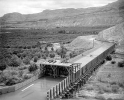
    And it’s fair to note that it is Hornbacher’s standing professional opinion that the city should complete the last 360 feet of the 4,000-foot-long pipeline installed before the proposed hydropower project ran into political turmoil and was mostly shelved by the city council.

    He has consistently pointed out that the pipeline is a better way to move a lot of water out the reservoir than running it down the hillside just to the east of the reservoir. However, the city does routinely run 3 to 4 cubic feet per second (cfs) of water down the hillside toward the creek, but Hornbacher is concerned that a flow of 52 cfs could damage Castle Creek Road.

    A water tight case?

    At an Oct. 21 budget work session, Hornbacher was asked by council to answer questions about the $750,000 line item in the 2015 budget. (On meeting video, start at 26:52).

    There was no staff memo on the topic and the May 27 dam inspector’s report was not in the public packet, nor was the last inspector’s report from April 2012.

    However, the discussion turned toward the May report from Gleason.

    “The report requires that we complete, or provide some level of a low-level drain line, or outlet, to this reservoir,” Hornbacher told the council. “Completing the drain line does provide that low-level outlet to the reservoir. So we do have an action item required by the dam safety division. If we do not comply with that in a method that is acceptable to them, then they are forced to take action. “

    At another point, Hornbacher told the council, “We need a have plan in place, something that we can demonstrate within the next several years, 2017, that you know, we’ve got something already done or that we’re taking this tangible action,” Hornbacher said. “And certainly completing the drain line is that action. If we were to try to look at other mechanisms, that would either require us to make modifications at the reservoir or provide other types of facilities that could drain that reservoir.”

    With that, and other statements, Hornbacher consistently backed-up to his professional recommendation that the city complete the pipeline. And he only mentioned in passing the existing low level outlet.

    During public comment at city council on Oct. 27, Maurice Emmer, a former Aspen mayoral candidate and staunch opponent of the city’s hydro project, told the council that they should conduct their own research and not trust staff to give them all the information they might need to make a decision on projects such as Thomas Reservoir.

    “Staff makes a proposal, then it gives city council information to support the proposal,” Emmer said. “It doesn’t give council information that might undercut the proposal.” (Meeting video starts at 19:01).

    For example, Emmer pointed out that Hornbacher did not tell council that the dam had been inspected in 2012, or elaborate on how the existing low-level outlet might satisfy the state.

    And Hornbacher did not know, when asked by Councilman Dwayne Romero, how often the state inspects dams.

    “I was going to look that up and I didn’t,” Hornbacher said. “I would say it is somewhere between two to five years, I’m thinking it’s around three, which is why you know, we’ve got this report in 2017.”

    The state historically has inspected dams classified as “high hazard” dams, which pose a threat to human life, every year. It inspects significant hazard dams, which only pose a threat to property, every other year, as in 2012 and 2014 in the case of Thomas Reservoir, which has been classified as a significant hazard dam since at least 2012.

    It’s not clear why Hornbacher is citing a need to act by 2017, as Gleason, the dam inspector, said she would need proof of a low-level outlet by the next inspection, which is slated for 2016.

    Hornbacher, when asked, also did not cite the date of the last dam inspection, which was April 4, 2012.

    Thomas Leonard Reservoir was completed in 1966, although water had historically been stored on the site in wooden structures to feed an old hydro plant in the same location as the proposed plant.

    In 1989, the state concluded the city’s dam was under 10 feet tall, and didn’t meet its definition of a “jurisdictional” dam. So they stopped inspecting it. At the time it was classified as low hazard dam.

    Inspection reports in the early 1980s mention that the reservoir’s low-level outlet drains to the water treatment plant — and was considered acceptable.

    In 2010, when the city went to install its new penstock/emergency drain line, it had to rebuild the north side of the reservoir to a height of 19 feet, which put the dam back under the state’s jurisdiction.

    At that time, regulators saw that the dam, if breached, would damage some property below the reservoir, but not threaten any lives, and gave it a significant hazard classification. That did not change at the May inspection, as Hornbacher implied on Oct. 21.

    As to the overall damage that would be caused if the dam failed, a 2011 report by the city’s consulting engineers, McLaughlin Water Engineers, stated that “it is unlikely that buildings or roads would receive extensive damage as a result of a dam breach at Leonard Thomas Reservoir.”

    No other options?

    By the time Hornbacher was through discussing the completion of the emergency drain line with council on Oct. 21, it was clear he had persuaded them that his proposal was the only safe and correct course of action for the city to take to meet the requirements of the May inspection report.

    “So, summing it up for my purposes, this is a state-mandated action to put in this drain line?” Councilman Art Daily asked Hornbacher at the end of the discussion on Oct. 21.

    In response to Daily, who is an attorney with Holland and Hart, Hornbacher seemed to choose his words carefully.

    “The state mandates that we must have a low-level outlet,” Hornbacher said. “What we have available is a nearly completed low-level outlet, and that would meet the state requirements. So they are telling you, you have to do it. They don’t necessarily go and say this, this and this, is how.”

    “But some sort of drain line has got to go in?” Daily asked.

    “Yep, a low-level outlet has got to be established in there for emergency, you know, release of water or draining the reservoir,” Hornbacher said.

    “I guess, then the last question that comes to my mind is, are there any more equally efficient but more cost effective means of resolving the state requirement versus … this is the best solution?” Daily asked.

    “This is a really enduring and complete solution, and by that I mean that you’ve got this hardened route that takes it to the stream and empties into the stream without further erosion or damage there at the stream, you’ve sort of dissipated the energy,” Hornbacher said. “Any other option that you might pursue to get water out of that reservoir does not have such a direct route, so you’d be either placing that water in an unimproved, sort of drainage-like way, and movement of such water would then … start to erode, and cause other types of damage, and then … basically recovery costs or other impacts we can’t even foresee today.”

    However, it is also possible that there may be simpler and less expensive ways to meet the state’s requirements for a low-level outlet, without completing the emergency drain line — which the state has never required the city to install. And that’s what Hornbacher said on Friday he is now looking into.

    In fact, as Hornbacher briefly alluded to early in his remarks on Oct. 21, and confirmed on Friday, there is a low level outlet already in place at the reservoir, and it sends water to the water treatment plant, where it can then be released down to Castle Creek.

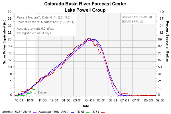
    All the state is requiring of a low-level outlet at Thomas Reservoir is that it be able to move 1 cubic feet per second (cfs) of water out of the reservoir over a five-day period, which would lower the water level by five feet — a state standard that technically doesn’t even apply to reservoirs as small as Thomas Reservoir.

    Under the “Outlet” section of her May 27 dam inspection report, Gleason wrote “it is our understanding that the only active outlet(s) discharge into the water treatment plant. According to Rule 5.9.6.2.1, a low-level outlet is required to draw down the reservoir under emergency conditions. Please either provide documentation of an existing bypass for treatment plant flows, or provide a low level outlet for the reservoir.”

    May was the first time Gleason had inspected Thomas Reservoir. She inspected another 60 dams this summer and said she will review issues identified in those inspections throughout the winter.

    As a state dam safety engineer, Gleason said she has wide latitude to work with dam owners, such as the city, to come up with reasonable solutions to concerns raised during inspections.

    According to a safety manual published by the state in 2002, “follow-up of the inspection often includes reviewing questionable conditions on site with the dam owner, explaining the problems and suggesting the best and/or most economical way to proceed in assuring the dam’s safety. Frequently, further studies by a consulting engineer are recommended.”

    “We work with the owner to make sure we are not requiring something that they can’t afford,” Gleason said. “The city could propose having a stand-by generator, a pump and a hose on site. Our office would typically accept such a solution.”

    Hornbacher, in his response to Daily or other council members, did not bring up the pump-and-hose option.

    Editor’s note: The Aspen Daily News collaborated with Aspen Journalism on this story and published in Monday, Nov. 3, 2014. Aspen Journalism was responsible for an error in the printed version of the Daily News story, as well as the initial digital version, as we said David Hornbacher is a licensed engineer, and he is not.

    More hydroelectric/hydropower coverage here.

    The latest newsletter from the Water Center at CMU is hot off the presses

    Water infrastructure as sidewalk art
    Water infrastructure as sidewalk art

    Click here to read the newsletter. Here’s an excerpt:

    Earlier this month, the Colorado Water Conservation Board approved a complete draft of Colorado’s Water Plan, which will be formally presented to Governor Hickenlooper on December 10. The draft will be finalized in December 2015.

    The plan steers clear of endorsing controversial projects, such as any new transmountain diversion from the west slope to the east slope, but does outline key issues to be addressed for any such project to proceed. You can find current drafts of each chapter here. For journalist Allen Best’s report on the plan and the process, click here.

    More Colorado Water Plan coverage here.

    Path to Grand Lake clarity standard far from clear #ColoradoRiver

    Grand Lake via Cornell University
    Grand Lake via Cornell University

    From the Sky-Hi Daily News (Hank Shell):

    Keep Grand Lake Blue. If you’re a resident of Grand County, you’ve probably seen those words pasted proudly to someone’s bumper. To the uninitiated, it seems like an innocuous, if not benevolent, goal. But to some Grand Lake fisherman, the issue is far from clear…

    …a recent study by Brett Johnson, a professor in CSU’s department of fish, wildlife and conservation biology.

    The study found that “pumping from Shadow Mountain Reservoir has an “enriching effect that should be beneficial to Grand Lake’s fish populations.”[…]

    In 2008, the Colorado Water Quality Control Commission set in motion a process to develop a clarity standard for Grand Lake.

    Most of the solutions proposed so far would include bypassing Grand Lake, eliminating the influx of dirty, nutrient rich water from Shadow Mountain Reservoir.

    In turn, Johnson postulates this could result in declines in sport fish growth and production.

    During the Nov. 20 meeting, Katherine Morris, Grand County’s water quality specialist, raised some concerns with Johnson’s study, namely that the nutrient sources that Johnson identified were primarily cyanobacteria.

    Cyanobacteria are less edible than phytoplankton, and when they die in large quantities, they can be toxic.

    Johnson has conceded that pumping cyanobacteria into Grand Lake wouldn’t be a good idea, Morris said.

    Cyanobacteria are currently the primary producers in both Grand Lake and Shadow Mountain Reservoir.

    “If we weren’t pumping the wrong nutrient ratio into Grand Lake, that might not be a problem,” Morris said.

    Grand County will be issuing a rebuttal to the study, Morris said.

    Weekly Climate, Water and Drought Assessment of the Upper #ColoradoRiver Basin

    Upper Colorado River Basin month to date precipitation November 1 thru 23, 2014
    Upper Colorado River Basin month to date precipitation November 1 thru 23, 2014

    Click here to read the current assessment. Click here to go to the NIDIS website hosted by the Colorado Climate Center.

    Fountain Creek: Will potential Pueblo County stormwater lawsuit impact the Southern Delivery System?

    Southern Delivery System route map -- Graphic / Reclamation
    Southern Delivery System route map — Graphic / Reclamation

    From the Colorado Springs Independent (John Hazlehurst):

    Let’s consider the Southern Delivery System, which, according to a 2013 white paper from Colorado Springs Utilities, will cure our water worries.

    “SDS is more than a pipeline,” wrote CEO Jerry Forte. “SDS will serve as an engine driving more efficiency, effectiveness and reliability in our system, while protecting water rights from future threats. SDS makes our entire water system more than the sum of its parts.”

    And if SDS isn’t available? Forte predicted higher rates, permanent watering restrictions and, as other systems age, the risk of long-term outages.

    “A future without SDS,” Forte concluded, “could jeopardize our ability to meet future water demand, the reliability of our system, our valuable permits and approvals, and our community’s economic stability.”

    There’s a tiny little cloud on the horizon — the lawsuit Pueblo County may be preparing to file over Colorado Springs’ inability to fund reliable flood control in Fountain Creek. And that’s to say nothing of a similar lawsuit threat from the Lower Arkansas Valley Water Conservancy District, which isn’t related to SDS directly but still could imperil the project.

    CSU has issued a harrumphing press release, claiming a lawsuit from Pueblo would be without merit. But is it possible that Pueblo, and/or its ally, could prevail?

    I’m not a distinguished attorney (you’ve confused me with my daughter, Melanie Hazlehurst Gavisk). But although the law’s nuances may elude me, I’m not encouraged by CSU’s (or the city’s) track record in litigation…

    So here we are again. What happens if we lose, and local voters refuse once again to fund stormwater infrastructure?

    So far, we’ve spent about $600 million on SDS, most of it borrowed. We’ll still have to pay it back. Worst-case scenario: Drought intensifies in California and the entire Colorado River Basin, our existing sources of supply are threatened, and we have to fund a reuse/recycle system. Desirable as that may sound to some environmentalists, it’d be hugely expensive, and would drive water rates into the stratosphere. Lawns? Gardens? Trees? Forget ’em.

    There’s a solution at hand, though. If Council agrees to refer to the ballot Mayor Steve Bach’s proposal to issue $160 million in capital improvement bonds to fund stormwater and other infrastructure for the next five years, and our flighty voters approve — problem solved for now.

    More Southern Delivery System coverage here.

    #COWaterPlan: “if you can streamline the permit process, it’s going to be helpful for the state” — Alan Hamel

    Colorado Water Plan website screen shot November 1, 2013
    Colorado Water Plan website screen shot November 1, 2013

    From The Pueblo Chieftain (Chris Woodka):

    If nothing else, the push to create a state water plan has led to a lot of talk about water.

    “It has been a great opportunity,” said Alan Hamel, who chaired the Colorado Water Conservation Board last year when the idea for the plan was hatched. “We have created a lot of interest. But there’s still a lot of work between the draft and the final version.”

    The draft state water plan will be presented next month to Gov. John Hickenlooper, who issued the executive order for the plan.

    Hamel and his colleagues on the CWCB got one last look at the draft document at last week’s meeting.

    What’s most significant to Hamel is the volume of public responses to the plan. More than 13,000 unique comments were received, along with 11,800 pages of form letters from people who wanted to see their concerns represented in the state water plan.

    “There was a lot of passion in those comments,” Hamel said.

    Among the major themes:

    – Protection of the prior appropriation doctrine in the Colorado Constitution and subsequent court decisions. It grants seniority to the earliest use of water in the same stream system.

    – Urban conservation programs that reduce the need to bring water from other sources to serve growing populations along the Front Range.

    – Protection of rivers and streams for environ­mental and recreational uses.

    – Preservation of farmland in Colorado.

    – Development of the Colorado River, either for or against.

    Hamel believes the chief value of a state water plan will be in how limited resources will be used to fund water projects and in removing permitting barriers to worthwhile enterprises.

    “I think if you can streamline the permit process, it’s going to be helpful for the state,” he said. “I think the plan will bring a good collaborative approach.”

    Hamel was skeptical of the state’s ability to complete the draft in a little more than a year, but is now optimistic that the final version can be in place by December 2015. Part of the reason is the work that has been going on for more than a decade with the Statewide Water Supply Initiative, Interbasin Compact Committee and the nine basin roundtables.

    “The timelines were extremely short. We had a new director at the CWCB. But the staff, roundtables and IBCC stepped up to complete the project,” he said.

    Early last year, the state Legislature also included a separate process that got even more people involved in commenting on the plan.

    Despite the number of comments, there are still areas where the public needs to be better informed about how water resources are managed, Hamel added.

    “We still have a lot of education to do,” he said.

    There may also be a few holes in the plan.

    The issue of tying new growth to available water supplies remains in the hands of local authorities within Colorado and would be difficult to include in the final plan, Hamel said.

    “But the state can encourage networking and ideas,” he said. “The plan would bring a more coordinated approach.”

    More Colorado Water Plan coverage here.

    Drought news

    Click here to go to the US Drought Monitor website. Here’s an excerpt:

    Summary

    An unsettled, somewhat milder weather pattern developed over the nation, with locally heavy rain in parts of the south affording some drought relief. Farther east, showers in the Mid-Atlantic and Northeast mostly prevented expansion of abnormal dryness, though rain largely bypassed southern Pennsylvania during the period. Locally heavy downpours eased drought in the southeastern Plains. In contrast, the West’s core drought areas remained dry, though additional heavy rain and mountain snow were observed in parts of the Northwest…

    Central Plains

    Despite a mostly dry, warmer week, the drought depiction over the central Plains remained unchanged. Long-term drought remained entrenched over the central High Plains, where precipitation dating back 36 months has tallied 60 to 75 percent of normal…

    Southern Plains and Texas

    Dry weather in western portions of the region contrasted with locally heavy downpours in the east. The drought depiction over the southern High Plains remained unchanged, with widespread Severe (D2) to Extreme (D3) drought noted from western Kansas into northern Texas. Farther east, moderate to heavy rain was noted in south-central Oklahoma, with numerous reports of 3 to more than 5 inches west of Lake Texoma. Likewise, moderate to heavy rainfall (1 to 6 inches) was noted across much of central and eastern Texas, with the highest concentration of heavy rain near San Antonio and Austin. Consequently, there were widespread reductions to drought intensity and coverage in the areas where rain was heaviest…

    Western U.S.

    Unsettled conditions in the north contrasted with ongoing drought elsewhere. Despite the northern precipitation, there were no changes to the drought depiction as experts in the field await further information regarding the potential benefits of the precipitation. Farther south, additional drought increases were likewise put on hold as all eyes turn toward the much-anticipated arrival of moisture later in the upcoming period.

    For the second consecutive week, a steady plume of Pacific moisture produced 1 to more than 4 inches (liquid equivalent) of precipitation in northern portions of the Cascade Range, with lesser totals (0.5 to 1.6 inches liquid equivalent) noted farther east in the northern Rockies. Despite the beneficial moisture, the drought areas of southwestern Oregon are still contending with the impacts of last season’s poor end to the Water Year; 12-month precipitation averaged 65 to 85 percent of normal in the state’s remaining drought areas, though deficits diminished somewhat.

    Despite a southward shift of the precipitation over the period, the moisture during the week not sufficient to afford drought relief to California. The rain, which tallied locally more than 2 inches in northern California, will certainly benefit pastures and begin the process of aiding reservoirs. However, the moisture still fell well short of what is needed to ease the impacts of a three-year drought. In the core Extreme (D3) to Exceptional (D4) Drought areas north of Sacramento (where the bulk of this week’s rain fell), the 36-month precipitation averaged 60 to 75 percent of normal. Farther south, the abysmal start to the current Water Year (which began October 1) continued; rainfall to-date (since October 1) has totaled 20 to 50 percent of normal in the Exceptional Drought (D4) areas around San Francisco, and locally less than 20 percent of normal in the D4 around Los Angeles. Likewise, the dry, mostly mild start to the winter has left snowpacks in the Sierra Nevada well short of normal.

    In the Great Basin and Four Corners, there were no changes to this week’s drought depiction despite the very poor start to the current Water Year, particularly in western portions of the region. The season’s poor initial prospects are reflected by season-to-date (since October 1) precipitation, which has totaled locally less than 10 percent of normal in the Great Basin and western portions of the central and southern Rockies, with most areas reporting less than 30 percent of normal. Changes to the drought depiction across much of the west are typically slow to occur during the early part of winter, as the development of the Water Year will be crucial to the region’s drought relief (or development) prospects…

    Looking Ahead

    An East Coast storm will disrupt holiday travel but provide additional, soaking rainfall to the Southeast while rain and snow fall over the Mid-Atlantic and Northeast. In the middle of the country, some snow is expected across the Upper Midwest and northern Plains, while dry weather prevails elsewhere. Out west, periods of rain and mountain snow will continue across the northern Rockies and Northwest. Meanwhile, much of California and the western Great Basin may receive rain and mountain snow from a late-week storm system, while unfavorably dry conditions prevail in the Four Corners region. The NWS 6- to 10-day outlook for December 1–5 calls for near- to above-normal temperatures nationwide, except for colder-than-normal conditions across the northern Plains and Upper Midwest. Meanwhile, above-normal precipitation in the eastern and western U.S., including California, will contrast with drier-than-normal weather across central and southern portions of the Rockies and Plains.

    Pueblo Board of Water Works board OKs $35.79M budget

    Pueblo photo via Sangres.com
    Pueblo photo via Sangres.com

    From The Pueblo Chieftain (Chris Woodka):

    Replenishing the water development fund, beginning work to convert Bessemer Ditch shares and continuing to swap out old meters for automated equipment are major projects envisioned by the Pueblo Board of Water Works in its 2015 budget.

    The board Tuesday approved a $35.79 million budget that will mean a 3.25 percent increase for Pueblo Water customers. The increase also will be applied to all multiyear water leases.

    No one protested the hike at a public hearing Tuesday.

    The rate hike is an average $1.16 increase in the monthly billing for residential customers with a 1-inch meter.

    “When looking at the Front Range cities’ average monthly bills, the board has the lowest cost of water for major water utilities,” said Executive Director Terry Book.

    Contributions to the water development fund are expected to top $1 million this year, with some of the revenue from the $5.5 million Xcel Comanche plant lease providing the money.

    The fund is used for onetime projects such as the acquisition of water rights and large infrastructure projects. Contributions had been on hold since the 2009 purchase of Bessemer Ditch shares and revenues used to service debt.

    Engineering and legal work on the Bessemer Ditch shares should begin with the anticipated filing of a change case in water court next year. The shares, which are being leased back to farmers, must be converted before the water can be used for municipal purposes.

    The water rights were purchased partly as a defensive measure to prevent El Paso County communities from obtaining them. The water may not be needed until future growth occurs and the purchase agreements provided a 20-year leaseback option.

    Pueblo Water has replaced about 80 percent of its water meters with automated equipment. It will replace about 4,000 more for about $1 million next year.

    More Pueblo Board of Water Works coverage here.

    The NIDIS November 2014 newsletter “Dry Times” is hot off the presses

    Cover of November 2014 Dry Times from NIDIS
    Cover of November 2014 Dry Times from NIDIS

    Click here to read the newsletter. Here’s an excerpt:

    If you’re the boss, how much water would you give to the farms that grow your food? To the lakes and streams where the fish and animals live? To the power plants that make the electricity that runs your television?

    And what happens if the next year, you only have half as much water to hand out?

    Some Boulder, Colorado, kids answered these questions through a water budgeting game meteorologist Lisa Darby developed in collaboration with the National Drought Mitigation Center (NDMC) in Lincoln, Nebraska. The kids were part of an August day camp program at a local non-profit, the Safehouse Progressive Alliance for Nonviolence.

    The game covered where our water comes from, how it’s used, and what might happen if a drought occurs. (Guess what uses the second biggest proportion of household water in Denver? Toilets!)

    Highlight video of Come Hell or High Water the 2014 @SCWConference with @COWatershed

    Colorado Springs voters might decide stormwater funding — The Colorado Springs Gazette

    Channel erosion Colorado Springs July 2012 via The Pueblo Chieftain
    Channel erosion Colorado Springs July 2012 via The Pueblo Chieftain

    From The Colorado Springs Gazette (Monica Mendoza):

    Colorado Springs Chief of Staff Steve Cox presented a capital improvement and stormwater funding plan to the City Council on Monday that he’s hoping will go to voters in April.

    He’s asking that the City Council put a question on the ballot seeking voter approval to issue $160 million in sales and use tax revenue bonds to pay for street improvement, parks, public safety and stormwater projects. The plan would not increase taxes or fees, he said. Instead, the bonds would be paid back from the city’s general fund.

    “This bonding proposal will allow the city to accelerate spending on key capital improvement projects,” Cox said.

    The plan would allow the city to spend $15 million a year to improve streets, $8 million a year on flood control projects, $4 million a year on public safety equipment and structures and $2 million a year on parks. The projects would be completed in five years and paid for over the next 20 years, city officials said.

    Cox said it is a way to address the city’s highest priority needs.

    “It’s not meant to solve the problem,” he said to the City Council. “But it is meant to make headway.”

    The council will decide in December whether to put the question on the April ballot.

    The council had endorsed a regional stormwater funding plan that went to voters Nov. 4 and would have created a partnership with El Paso County, Manitou Springs, Green Mountain Falls and Fountain to plan and fund flood control projects. It would have assessed a fee on every property owner in those four communities and most of El Paso County. Voters turned down the plan.

    Cox said this bonding plan would provide $145 million and pay for about 70 capital improvement projects that have been on the high-priority list, including bridge rehabilitation on Fillmore over Monument Creek, citywide tree trimming, emergency generators, and improvement on the Fountain Creek channel.

    “The executive branch sees this as an intermediate, half-decade action plan to get us moving on high-priority, backlogged CIP (capital improvement projects) in all four function areas,” Cox said.

    Council member Jan Martin called the plan a temporary fix. The backlog of flood control projects has been estimated at $700 million.

    “What is the longer-term solution?” she asked Cox.

    Cox said the long-term plan is still to be developed. The city has identified a backlog of capital improvement projects that total $1.3 billion.

    “The longer solution is obviously going to involve property tax increases or sales tax increases,” he said.

    Council member Merv Bennett called the plan a step in the right direction. Bennett was on the hot seat this month when he faced the Lower Arkansas Valley Water Conservancy District board members, who accused the city of Colorado Springs of violating the Clean Water Act because of its lack of permanent stormwater and flood control programs. The board sent Colorado Springs a letter Nov. 19 of its intent to sue over the matter.

    “I appreciate you putting these issues together,” Bennett told Cox. “But I hope everyone doesn’t believe this solves the problem.”

    Cox would not comment on the potential lawsuit, but he said the city has been working on flood control issues beyond spending. It recently updated its drainage criteria manual, which has stricter, rules for developers issues that affect water quality and water flow.

    In 1999, Colorado Springs voters approved the Springs Community Improvements Program, which was the sale of $88 million in municipal bonds to pay for 29 capital improvement projects. The projects were completed in 2004 and the debt, paid for from the general fund of about $7.9 million a year, is scheduled to be paid off in 2016.

    “With the SCIP bonds retiring in 2015 and 2016, the cash flow currently dedicated to those bond payments can be re-purposed to the proposed bond payments,” a handout from Cox to the City Council said. Under the proposal, the city would spend $11 million a year out of the general fund to pay back the bonds – about $3 million more than the current bond payments.

    Council member Don Knight said it’s a finance plan that raises concerns.

    “This year’s (2015) budget includes $1.5 million from reserve to balance the budget,” he said. “Now this is another $3 million liability on us. We are increasing the debt payment by $3 million instead of staying at $7.9 million.”

    The city would take the $3 million from its Capital Improvement Project fund, said Kara Skinner, the city’s CFO. “That would still leave $8.1 million in the general fund CIP budget for other pay-as-you-go CIP projects and emergency projects,” she said.

    More Fountain Creek coverage here.

    The November 2014 Uncompahgre Watershed Partnership newsletter is hot off the presses

    Uncompahgre River watershed
    Uncompahgre River watershed

    Click here to read the newsletter. Here’s an excerpt:

    UWP completes first mine remediation project at Michael Breen Mine

    The unpredictable early fall weather made UWP’s first mine remediation project at the high elevation Michael Breen Mine on Engineer Pass road very uncertain. But, we crossed our fingers for a glorious fall and forged ahead. First, Jack Pftersh of Alpine Archaelogical Consultants, LLC in Montrose completed site recordation and assessment of a historic ore load-out structure, just as the first snow blanketed the high country at the end of September. An expedited review of his report by the State Historical Preservation Office (SHPO) gave us the green light to proceed with stabilization of the load-out. Meanwhile, Jeff Litteral of Colorado’s Division of Reclamation, Mining and Safety (DRMS) finalized agreements and plans to construct a diversion ditch for a draining adit, install a culvert and stabilize the structure. The remediation work began in early October. The weather turned warm and dry and all major tasks were completed by Halloween.

    More Uncompahgre River watershed coverage here.

    That half-decade leading up to a successful wilderness bill was American democracy at possibly its sausage-making best — George Sibley

    Trappers Lake
    Trappers Lake

    From the Summit Daily News (George Sibley):

    Westerners celebrated two birthdays worth noting toward the end of summer, but most paid attention to only one, the 50th anniversary of the Wilderness Act. The other was the 50th anniversary of the start of construction of the Fryingpan-Arkansas Project in Colorado, which eventually moved a lot of water from the Colorado River Basin to the Arkansas River Basin.

    I mention them together because it fits my sense of irony. The Fry-Ark Project, a heavy-duty tampering with natural hydrology in Colorado’s wild headwaters, was about as antithetical to the spirit of the Wilderness Act as one could imagine. Yet had the U.S. Congress not passed the 1962 act creating the project, a Wilderness Act would almost certainly not have been passed as early as 1964. And the West Slope headwaters of the Colorado River tributaries might not have today’s black-and-white division: official designated wildernesses cheek-and-jowl with the intrusive water-collection systems designed for East Slope cities.

    I mention this to counter the triumphalist history we heard this summer about what a slam-dunk the “wilderness revolution” was 50 years ago, somehow expressing the will of the vast majority of the people as it gained nearly unanimous votes in Congress, et cetera. That’s is true enough on the surface, but it sweeps under the rug the half-decade of contentious horse trading that went on inside Congress, and between Congress and the executive departments, as the nation began to negotiate a transition from an “Old West” of aggressive public-land resource development, to an urbanized and industrialized “New West” that would preserve for posterity and recreation the remaining public areas still “untrammeled” by human development and use.

    That half-decade leading up to a successful wilderness bill was American democracy at possibly its sausage-making best. It was Congress and executive leaders doing what Congress and executive leaders today seem to have forgotten how to do: After all the bloviating and harrumphing and bullying, they sat down to arm-wrestle their way to compromises that were acceptable enough to all parties. The full story of that process in the early 1960s is too large and complex to relate here; but at the end of it the Old West got more water projects, and the New West got a Wilderness Act.

    By the time all that negotiating was completed, the wilderness bill that passed was no longer really “revolutionary”; it was a reasonable evolution of existing public-land law. A new public-land designation was created, but the Old West extractive industries (on which the New West was built) were given 25 years to explore for developable resources in proposed wilderness areas, historic grazing rights were grandfathered in, and the president had executive authority to permit water projects in wilderness areas.

    The hardcore wilderness advocates screamed that these compromises would kill the wilderness ideal, but this is hard to substantiate today. That quarter-century of development is long finished, and more than a hundred million acres of the nation’s land are now under wilderness protection. Of course, that’s not enough for some and too much for others. New wilderness will probably be added incrementally, but only if Congress relearns the lost art of working through conflicts to acceptable compromises.

    I find that, 50 years later, my own ambivalence about the Wilderness Act is unchanged. On the one hand, I favor almost anything that makes us slow down and think about our presence on our public lands. But I remain bothered by the “First World” piety that infused the wilderness movement from the start — saving what’s left of Nature from ourselves (and everyone else). How is it not a class movement, by and for the beneficiaries of the richest, most resource-intensive “lifestyles” ever?

    $25 million in improvements in store for the #SouthPlatte River through Denver

    From Confluence Denver:

    On the South Platte River in Denver, numerous projects known collectively as River Vision are underway, aiming to improve both recreation and ecology. While the river remains a work in progress, it’s unrecognizable compared to the mess it was 50 years ago.

    Once again, the South Platte River is entering a new era.

    With $24.5 million worth of improvement projects underway in Denver, the once-forgotten waterway is blazing a trail for urban river restoration. The South Platte also represents one of the biggest economic opportunities for the city, according to Mayor Michael Hancock, with the riverfront poised for a boom on both the north and south sides of town.

    More South Platte River Basin coverage here.

    Dredging planned for Evergreen Lake in the spring

    Evergreen Colorado Flooding September 2013 via Business Insider
    Evergreen Colorado Flooding September 2013 via Business Insider

    From the Canyon Courier (Beth Potter):

    Officials are planning to dredge Evergreen Lake in the spring to clean out sediment brought in by the September 2013 flooding.

    The “stealth” dredging project will be done with a pontoon boat to minimize the impacts on lake users, said Dave Lighthart, general manager of the Evergreen Metropolitan District.

    Sediment material will be pumped from the boat through a pipe to a “de-watering” operation that will separate the water from the sediment. The water will be treated before being put back into the lake, Lighthart said.

    “We’re trying to be as unobtrusive possible,” Lighthart said. “The lake is pretty visible and used for recreation, so we don’t have that ability to isolate and drain it.”

    The project is expected to take a little longer and cost a little more than it would otherwise, because of its unobtrusive nature, Lighthart said. But the lake also serves as Evergreen’s raw drinking water source, which means the water can’t be pumped out, he said.

    Some $880,000 in Federal Emergency Management Agency funds and state funds will pay for the project. An estimated 12,000 cubic yards of sediment were deposited in the lake during the 2013 flooding, Lighthart said.

    The sediment will help with cleanup of the EDS Waste Solutions Inc. site on Highway 73. The 549-acre site is owned by the city and county of Denver, which plans to get the land back to its natural park-like state over a two-year period, said Bob Finch, natural resources director at Denver Mountain Parks, a division of the Denver Parks and Recreation Department.

    “(This) helps them, and it certainly helps us,” Lighthart said of the plan to take the sediment to the landfill site.

    Dredging work is expected to start in late March or early April after ice has melted off the lake, Lighthart said. It’s expected to take place near the south side of the “islands,” he said, where a survey showed most of the sediment was deposited during the flooding. Government funds must be spent by June 2016, he said.

    More Bear Creek watershed coverage here.

    Transmountain water: “I think it’s really in the crosshairs” — Chris Treece #COWaterPlan #ColoradoRiver

    Colorado transmountain diversions via the State Engineer's office
    Colorado transmountain diversions via the State Engineer’s office

    From The Grand Junction Daily Sentinel (Gary Harmon):

    Colorado’s first stab at a statewide water plan makes no direct call for a new transmountain diversion of West Slope water to the Front Range. That doesn’t mean West Slope water is off the table, though, said observers and a member of the Colorado Water Conservation Board. Far from it.

    “I think it’s really in the crosshairs,” said Chris Treese, spokesman for the Colorado River Water Conservancy District, “where it has always been.”

    To be certain, said Russ George, a former Western Slope legislator and current member of the water conservation board, the desires of Front Range developers remain undiminished. The board’s draft plan, which was approved last week in Berthoud, “will sharpen the debate that’s always lurking in the back room,” George said.

    George proposed nearly a decade ago that water managers in each of the state’s river basins gather information about their water uses, supplies and other data. The process resulted in the “roundtable” process that is to yield a water plan a year from now.

    That’s when Gov. John Hickenlooper is expected to complete the plan.

    Don’t expect the final product to look much different than the draft submitted by the water conservation board to the governor, George said.

    “We are the governor’s arm” on the issue, George said.

    What Colorado has long needed is a framework of information about how much water the state has, where and how it’s put to use, and what, if any, is left over.

    The water plan is “a very sensible intellectual effort to do that,” George said, adding that it has been an open process. “The general public has been a player and that has not always been the case.”

    It also gives the Western Slope an equal voice in water discussions, “which is all we ever needed, or wanted,” George said.

    Demand for more water on the east side of the state isn’t going to go away. The ability to build transmountain diversions should be protected, Denver Water said in its comments on the state plan.

    “We owe it to future generations to leave options open to determine the best way to utilize the state’s water resources,” the purveyor of water to 1.3 million people said.

    A more realistic assessment of the amount of water that runs down the Colorado is in order, though, said Max Schmidt, general manager of the Orchard Mesa Irrigation District.

    “They (Front Range officials) say there’s a lot more water in the river than there is. It runs right outside my office and I’ve walked across it two times in my brief four years here.”

    The reason the river runs dry? Transmountain diversions, Schmidt said.

    Whether the water plan — which the authors say will always be a work in progress — will help resolve differences is also less than clear, Schmidt said.

    It took a decade for the West Slope and Denver Water to reach the comprehensive agreement on managing the Colorado River and the statewide plan is all the more ambitious, Schmidt said.

    “I’m watching it very closely,” Schmidt said. “Sooner or later it’s going to blow up.”

    More Colorado Water Plan coverage here.

    Taking the deal: Energy firm trades leases for certainty on Roan Plateau — The Grand Junction Daily Sentinel #ColoradoRiver

    Drilling sites in a valley on the Roan Plateau via The Grand Junction Daily Sentinel
    Drilling sites in a valley on the Roan Plateau via The Grand Junction Daily Sentinel

    From The Grand Junction Daily Sentinel (Dennis Webb):

    A landmark deal canceling federal oil and gas leases on the Roan Plateau leaves Bill Barrett Corp. with just a sliver of its former holdings there, but it has high hopes about the prospects for the 4,650 acres it still controls. Nearly 500 wells could be drilled on that acreage, said Duane Zavadil, a senior vice president for the company.

    In a lawsuit settlement announced last week, the company agreed to give up 17 of 19 leases it owned on the top of the plateau west of Rifle and be reimbursed about $47.6 million by the Bureau of Land Management. The canceled leases cover about 36,000 acres.

    But Bill Barrett Corp. considers the leases it retained to have the highest prospects of the 19, given that they are immediately bordered on the south and west by acreage where companies have drilled producing wells, and where access roads, pipelines and other infrastructure already are in place.

    The settlement resolves a lawsuit brought by conservation groups, and is one of the biggest lease buybacks ever for the BLM, and the biggest ever for the agency in Colorado.

    “We were trading off acres and reserves for trying to drive a degree of regulatory and litigation certainty,” Zavadil said.

    The settlement itself was no windfall for the company, he notes. Barrett bought the 19 leases for $60 million in 2009 from Vantage Energy, which had acquired them at the BLM’s Roan Plateau lease sale a year earlier for $57.6 million. But Vantage retained a 10 percent interest in them.

    The $47.6 million the BLM is reimbursing for 17 of the leases covers what Vantage paid for them at the lease sale, and about $53,500 in total annual rental payments made on the canceled leases. Zavadil said Vantage will share in the reimbursement Barrett receives. In a news release Monday, Barrett said it will end up with $42.3 million in the settlement.

    Under the deal, there’s no reimbursement for other costs such as legal fees related to the lawsuit and having money tied up for years in leases in legal limbo. But Zavadil said the reimbursed amount “is really all that could be accomplished” because there’s no federal mechanism for reimbursing for such additional expenditures in such cases.

    The settlement “is equitable, it’s fair, it sort of is what it is,” said Zavadil, who said Bill Barrett Corp. never asked for more or less than that amount and no other amount ever was contemplated in settlement discussions.

    As for settling in general, BBC knew that might be a necessity when it bought the leases due to the lawsuit that conservationists filed even before the 2008 lease sale occurred. But Zavadil said while Vantage already had been in settlement talks that potentially involved giving up some leases, Barrett initially had hoped to hold on to all of the leases and instead reach an agreement with conservation groups on measures to mitigate the impacts of developing them.

    “We clearly erred in that assessment,” he said.

    In 2010, Barrett showed its willingness to compromise in drilling projects on federal lands when it struck a deal with environmentalists to downsize its development plan for the West Tavaputs Plateau outside Price, Utah, to address concerns such as protection of lands with wilderness characteristics.

    But the company couldn’t get buy-in from conservation groups on developing all its Roan Plateau leases. And in 2012, a federal judge found fault with the BLM’s management plan that led to those and other leases being offered. Barrett appealed and the BLM reopened its Roan Plateau planning process.

    It was during court-mandated mediation following Barrett’s appeal that the concept of giving up leases began to solidify.

    One thing that helped facilitate a settlement was the fact that the lease areas Barrett most wanted to keep and the areas that conservationists most wanted to protect generally didn’t overlap. The remaining Barrett lease areas don’t have habitat for endangered plants or for the native Colorado River cutthroat trout, and are largely landlocked by private property and not easily accessible to the public, which minimizes their recreational value, Zavadil said.

    BBC also has agreed to limit its drilling to seven well pads on the two leases combined.

    Zavadil said Barrett worried that had it not settled, a whole new round of litigation would have followed the BLM’s revised Roan Plateau plan.

    “What we were trying to avoid was more delay in having capital tied up without any real hope of sort of resolving the litigation,” he said.

    Instead, the BLM will consider the settlement agreement as one of its alternatives in its new planning process, which it hopes to finish within two years. Groups involved in the suit waive the right to further challenge the BLM’s decision if it selects the settlement alternative.

    Zavadil said Bill Barrett Corp. is happy with the settlement and believes it’s “as good an outcome as one could hope for.”

    Michael Freeman, an attorney for the group Earthjustice who represented conservation groups in the lawsuit, said while both sides litigated the case pretty hard up through the district court decision, afterward they realized a win-win situation was possible.

    “To Barrett’s credit they were willing to work really hard to get it done and make it happen,” Freeman said.

    Zavadil said Barrett will look at natural gas prices once the BLM completes its revised Roan plan to see if it makes sense to develop the acreage then. Gas prices began declining in 2008, even before Barrett’s Roan purchase, but prices have remained depressed ever since due in large part to a boom in domestic production from shale formations. And drilling on the plateau top will cost more than operations closer to the Colorado River valley floor, where access is easier and wells don’t have to be drilled as deeply to reach gas-bearing formations.

    Zavadil noted that gas price isn’t the only determinant, pointing out that WPX Energy has been drilling on highlands locations.

    “But we have a lot of assets that have a higher rate of return at this point of time” than the Roan leases, he said.

    Barrett has shifted its focus in recent years from gas to oil production, which as a result has meant a shift in its attention from western Colorado’s gas-based Piceance Basin holdings to assets in northeastern Colorado and in northeastern Utah’s Uinta Basin. In September it announced the sale of its other Piceance Basin natural gas holdings, which included some 950 wells south of Silt. It also has sold other gas assets including its West Tavaputs acreage in Utah.

    Zavadil said he can’t speak to whether Barrett’s Roan acreage might be put up for sale, any more than whether anything else the company owns is for sale.

    “At any moment in time, it’s all for sale, and none of it’s for sale,” and it all depends on whether someone comes to BBC offering the right price on any of its assets, Zavadil said.

    But he said it’s safe to say Barrett will pursue the regulatory authorizations to drill on its Roan leases.

    He said it’s also important to understand that the company didn’t pursue the settlement and reimbursement for the 17 leases because of low gas prices. If not for the legal and regulatory risks that were involved, he said, Barrett “would still absolutely own every acre” it had acquired on the Roan Plateau.

    roanplateausettlementmapviadailysentinel11212014

    From The Grand Junction Daily Sentinel (Dennis Webb):

    In what is being hailed as a model for how to deal with oil and gas development on other special landscapes, 17 leases are being canceled on top of the Roan Plateau under a deal intended to let drilling go forward on other leases on and below the plateau rim. Seventeen of 19 oil and gas leases owned by Bill Barrett Corp. on the plateau top are being canceled, and the company will be reimbursed about $47.6 million for the costs of acquiring and making annual rental payments on the canceled leases under a lawsuit settlement announced Friday.

    “In a nutshell, I think this is a really positive resolution,” Interior Secretary Sally Jewell said in an interview with The Daily Sentinel.

    The Bureau of Land Management also has agreed to pay $400,000 to settle all claims to attorney fees, expenses and costs by the conservation groups that brought the lawsuit. Those are among the terms of a deal to resolve a lawsuit challenging the BLM’s management plan leading to the leasing of some 55,000 acres on and around the Roan Plateau west of Rifle in 2008.

    The deal doesn’t guarantee that the acreage where the leases were canceled will be off-limits to leasing. Rather, the BLM has agreed to consider the settlement agreement as one alternative in an ongoing supplemental environmental impact statement re-evaluating its prior Roan Plateau plan because of a 2012 court ruling in the lawsuit.

    If the BLM chooses to again lease the 17 canceled parcels, the conservation groups could sue again or otherwise challenge the decision.

    Garfield County Commissioner Tom Jankovsky said he “would be amazed” if the BLM didn’t select the settlement agreement as its final management alternative.

    Said Michael Freeman, an Earthjustice attorney who has been litigating the Roan Plateau case for conservation groups, “What this deal does is to create a path forward to give the Roan the kind of protection it deserves. There’s more work to be done to implement the settlement.”

    Legally, the BLM can’t commit to a course of action until it finishes its new planning process, Freeman said. But he also is confident that the settlement alternative will be selected.

    “What we’ve agreed to in the settlement provides kind of a consensus proposal for how to manage the Roan. We think it’s a really good balance between protecting the habitat, the lands of the Roan, but also allowing responsible drilling to happen in appropriate places,” he said.

    The settlement agreement calls for the lands where the leases were canceled to be closed for leasing for the life of the revised management plan, Freeman said.

    If the BLM selects the settlement agreement as its alternative, the conservation groups involved in the suit also “additionally agree to engage as broad a spectrum of the environmental and conservation community as possible” and encourage them not to pursue an administrative or legal challenge to it, the agreement says.

    Leases issued in 2008 on the Roan but not canceled could begin seeing development once the BLM’s planning process is complete, something the agency has agreed to try to accomplish within two years.

    “For the first time in decades western Colorado’s natural gas companies are very close to securing responsible drilling on and around the Roan Plateau. This compromise will provide decades of jobs and hundreds of millions of dollars for local communities,” said David Ludlam, executive director of the West Slope Colorado Oil and Gas Association.

    Jewell, Gov. John Hickenlooper and other officials announced the settlement in Denver Friday.

    Hickenlooper said in a release, “We are thrilled to see resolution for this decade-long controversy over one of Colorado’s most special places. This settlement will protect the valuable fish and wildlife resources atop the Roan Plateau, while clearing the way for orderly development to take place elsewhere in the planning area.”

    The Roan Plateau rises from the Colorado River Valley to some 9,000 feet in elevation and is noted for its biodiversity. It provides important habitat to deer and elk, is home to rare plants and provides important habitat for native Colorado River cutthroat trout, which now occupy less than a 10th of its historic range. The settlement cancels all the leases in the Trapper and Northwater Creek watersheds, which conservationists say hold the best cutthroat trout habitat on the Roan.

    Bill Barrett Corp. once had projected drilling more than 3,000 wells on its Roan leases.

    “This settlement helps us achieve the goal of preserving important natural areas like the Roan Plateau in Colorado while oil and gas development continues in Colorado and across the West,” said Pete Maysmith, executive director of Conservation Colorado.

    The settlement contains restrictions on how Bill Barrett Corp. can develop its two remaining Roan Plateau leases, including limiting it to seven well pad locations altogether on the leases.

    Twelve other Roan Plateau leases issued under the 2008 lease sale would remain in place under the settlement agreement. Those are owned by WPX Energy, Oxy USA and Ursa Resources. But the agreement requires that before drilling on those leases, the companies submit proposed master development plans, and include within them conditions to minimize impacts on wildlife and other resources, identified through consultation with the BLM and Colorado Parks and Wildlife.

    Jewell said that while she doesn’t like lawsuits, this suit identified opportunities for the BLM to do a better job on the Roan Plateau plan. She said she appreciates the plaintiffs raising concerns and others recognizing those concerns and coming to the table to settle, and said the settlement is “a model for collaboration” on public land management.

    The Interior Department is looking elsewhere “at what are the areas too special to develop,” and trying to steer drilling to areas of high development potential and less conflict, so there’s more certainty for industry, she said.

    Freeman said the settlement is an example of how the BLM “can strike a balance that protects the really important areas of public lands that shouldn’t be drilled,” while identifying places where drilling is appropriate.

    The federal government shares about half of its oil and gas lease revenue with the state of Colorado, which will be responsible for reimbursing its portion of the revenue Bill Barrett Corp. will be receiving under the deal. That will occur by the federal government withholding future royalty distributions to the state, BLM spokesman David Boyd said.

    Hickenlooper is pushing legislation to ensure refunding the canceled leases has no financial impacts on local governments, with which the state shares federal lease revenues.

    The state and local governments expect federal mineral lease revenue associated with developing the remaining Roan Plateau leases will more than offset the costs of canceling the 17 leases.

    Scot Woodall, chief executive officer of Bill Barrett Corp., said on the company’s website that he appreciated the community and elected-official support for the settlement.

    “It was critical to us that Garfield and Mesa counties, who host our business, support the agreement. To that end, the county commissioners, in particular Garfield Commissioner Tom Jankovsky, worked tirelessly along with State Representative Bob Rankin, a member of the Joint Budget Committee of the General Assembly, to ensure that local communities would not suffer an economic loss as a consequence of settlement.”

    Rankin is a Republican from Carbondale.

    In an interview, Duane Zavadil, a senior vice president for the company, said the work of Hickenlooper, U.S. Rep. Scott Tipton, R-Cortez, and U.S. Sens. Mark Udall and Michael Bennet, D-Colo., in encouraging Jewell to approve the deal was crucial.

    He also credited the BLM and Interior Department for being willing “to get creative … to cause this settlement to happen as well.”

    The plateau-top leases initially were acquired by Vantage Energy for $57.6 million. In 2009, Bill Barrett Corp. obtained a 90 percent interest in those lease under a $60 million deal.

    # # #

    Timeline of the Roan Plateau events

    1997— Congress passes Transfer Act shifting authority over the Roan Plateau acreage at issue from the Energy Department to the Department of Interior and Bureau of Land Management.
    2000-08 — BLM works on resource management plan for Roan, receiving more than 75,000 public comments on draft plan. Most favor strong protections and oppose drilling on public lands on top.
    July 2008 — Conservation groups sue, challenging BLM management plan paving way for oil and gas lease sale on Roan Plateau.
    August 2008 — Lease sale covering about 55,000 acres nets $114 million, which for the Bureau of Land Management at that time was the largest ever in total dollars in the continental United States.
    June 2012 — U.S. District Court Judge Marcia Krieger rules that the BLM failed to adequately consider keeping drilling off the plateau top by requiring use of directional drilling from surrounding lands, and failed to sufficiently consider air quality issues.
    August 2012: Bill Barrett Corp., owner of the leases on the plateau top, appeals the ruling. Conservation groups cross-appeal.
    January 2013: The BLM announces it will conduct supplemental planning process to address issues raised by court.
    Early 2013: Parties in litigation enter mandated mediation with an appeals court representative.
    Nov. 21, 2014: Settlement of suit announced; 17 leases will be canceled.

    Sources: Daily Sentinel archives, plaintiffs in lawsuit

    The plaintiffs

    Following are the conservation groups that legally challenged the Bureau of Land Management’s plan leading to leasing of some 55,000 acres for oil and gas development on the Roan Plateau:

    Colorado Mountain Club
    Conservation Colorado
    Colorado Trout Unlimited
    National Wildlife Federation
    Natural Resources Defense Council
    Rock the Earth
    Rocky Mountain Wild
    Sierra Club
    The Wilderness Society
    Wilderness Workshop

    More oil and gas coverage here.

    Sewage lagoons to be upgraded below ski resort — The Grand Junction Daily Sentinel

    Wastewater Treatment Process
    Wastewater Treatment Process

    From The Grand Junction Daily Sentinel (Gary Harmon):

    Work to upgrade two sewage treatment lagoons below Powderhorn Mountain Resort could begin soon with state officials monitoring the process closely. The Colorado Department of Public Health and Environment issued a notice of violation in September to Grand Mesa Metropolitan District No. 2 for concentrations of ammonia in the lagoons that exceeded the limits of the permit for the facility. There are no allegations that the district released polluted water into a nearby stream.

    “We did receive the notice and we knew it was coming,” said Larry Beckner, attorney for the district.

    The metro district began working about four months ago with Westwater Engineers in Grand Junction to upgrade the lagoons to meet current standards, Beckner said. The 1968 sewage-treatment system was to have been replaced by a new system to accommodate expected growth. That growth, however, hasn’t taken place. The treatment system, meanwhile, was to have been upgraded to meet standards that took effect in July 2010. The permit was administratively continued in 2012, Beckner said.

    The current permit for the water-treatment system included a compliance schedule to meet ammonia concentration limits, said Megan Trubhee, spokeswoman for the Department of Public Health and Environment’s Water Quality Control Division.

    “The metro district failed to complete those upgrades,” she said.

    The district is completing an evaluation of the facility, Trubhee said.

    Metropolitan districts are established under state statutes to finance community planning and infrastructure projects, including initial construction of streets and some utilities.

    Treated water from the lagoons is discharged into nearby Big Beaver Creek, which runs through pasture and farmland below, Beckner said.

    There has been no discussion about whether the health department would levy a fine in the case, Beckner said.

    The health department’s primary focus is to work with ​the district to ensure that compliance with the discharge ​permit ​requirements ​and Colorado’s Water Quality Control Act​ is achieved in a timely manner​ and no evaluation of potential penalties had yet been made, Trubhee said.

    Violations of the Water Quality Control Act can result in fines of up to $10,000 per day.

    More wastewater coverage here.

    The Water Values podcast: This Thanksgiving week listen to @CTWater CEO Eric Thornburg discuss his @waterforpeople trip to Rwanda

    The Lower Ark District is scoring Colorado Canal shares to keep the water in the Arkansas Valley

    Straight line diagram of the Lower Arkansas Valley ditches via Headwaters
    Straight line diagram of the Lower Arkansas Valley ditches via Headwaters

    From The Pueblo Chieftain (Chris Woodka):

    The Lower Arkansas Valley Water Conservancy District is purchasing Colorado Canal water rights from the Ordway Feedyard.

    “We’re purchasing the shares within the next 30 days to make sure the water stays in the Arkansas Valley,” said Jay Winner, Lower Ark general manager. “It’s about a $4 million package.”

    The Colorado Canal once irrigated 50,000 acres in Crowley County, but has largely fallen into the hands of Colorado Springs and Aurora through purchases made in the 1980s.

    Earlier, in the 1970s, canal shareholders began selling off shares of Twin Lakes to Colorado Springs and Pueblo. Later Aurora and Pueblo West also bought big blocks of Twin Lakes shares.

    The Lower Ark purchase from Ordway Feedyard includes 276 shares paired with Lake Henry storage, and 282 shares paired with Lake Meredith storage.

    The feedlot has other sources of water to meet its own needs, most significantly a 15-year lease signed in 2012 with the Pueblo Board of Water Works to supply 700 acre-feet of augmentation water annually for a pipeline completed last year.

    In another matter, the Lower Ark board last week accepted two conservation easements on the High Line Canal for Jason and Jennifer Stites. The easements are for a total of 224 acres with 18 shares of High Line water, for a cost of about $360,000. The easements were split for estate planning purposes, according to Lower Ark Conservation Manager Bill Hancock.

    More Lower Arkansas Valley Water Conservancy District coverage here.

    Fountain Creek: Mayor Bach outlines new proposal, no new taxes, no new fees, not enough dough

    Flooding in Colorado Springs June 6, 2012
    Flooding in Colorado Springs June 6, 2012

    From The Pueblo Chieftain (Chris Woodka):

    Colorado Springs Mayor Steve Bach Monday presented his proposal to City Council to address the backlog of high-priority, unfunded capital improvement projects including stormwater control.

    Voters in El Paso County turned down a regional drainage district fee that would have raised $37 million annually to address a $700 million backlog in projects.

    The issue of stormwater control on Fountain Creek has become central to a pending lawsuit by the Lower Arkansas Valley Water Conservancy District in federal court over Colorado Springs’ violations of the Clean Water Act.

    Pueblo County commissioners are looking into whether Colorado Springs is in violation of its 1041 permit for the Southern Delivery System.

    Bach wants to place a proposal on the April municipal ballot that would extend tax revenue bonds funded by sales and use taxes over the next five years. Voters would be asked to approve up to $160 million in Sales and Use Tax Revenue bonds to succeed the maturing Springs Community Improvement Program bonds. Bond proceeds will provide funding of $145 million to complete more than 70 capital improvement projects, which includes $75 million in neighborhood streets, $40 million for stormwater, $20 million for public safety and $10 million in parks. The balance of the proceeds would provide for the required bond reserve fund and the costs of issuance, according to a press release from Bach.

    “This is a holistic approach to address all capital improvement needs in our community without raising taxes or imposing a new fee,” Bach said. “Specific projects are planned in each of the five years based on professional staff recommendations as well as input by the community and City Council.”

    The $40 million over five years would address only about one-fourth of the $162 million in high-priority stormwater projects identified in a Colorado Springs study earlier this year. The city’s total backlog is $534 million.

    At $8 million per year, the amount dedicated to stormwater would be just half of the estimated $17 million generated by a stormwater enterprise fee abolished by City Council in 2009.

    More stormwater coverage here.

    CWCB: Drought update

    January 1, 2015 SWE forecast via Klaus Wolter
    January 1, 2015 SWE forecast via Klaus Wolter

    Click here to read the current update. Here’s an excerpt:

    Warm and dry conditions persisted throughout October and early November, with October 2014 the sixth warmest on record. However, recent precipitation and below average temperatures have resulted in improved snow accumulation across the state. The Arkansas basin, which has been the hardest hit by the drought, has received significant beneficial moisture this fall, and is no longer classified as experiencing extreme drought conditions; however severe conditions remain. Along the Front Range, water providers indicated that storage levels are at, or near, record levels, the South Platte basin is experiencing the largest positive departure from average in storage since records began in 1992.

  • Year-to-date precipitation at mountain SNOTEL sites, as of November 18th, was 82% of normal statewide. The Arkansas basin had the highest snowpack at 99% of normal, while the Yampa/White basin had the lowest at 73% of normal. This time of year it does not take much to increase snowpack levels and below average numbers are not of great concern.
  • The short term forecast calls for the mountains to get a good snowstorm this weekend into early next week. The plains will remain mainly dry, with a chance of snow on Thanksgiving.
  • Reservoir Storage statewide is at 105% of average at the end of October 2014. The lowest reservoir storage statewide continues to be the Upper Rio Grande, with 59% of average storage. The South Platte has the highest storage level at 147% of average.
  • In the South Platte Basin, Halligan Reservoir is spilling, which is unprecedented. While Carter Lake, Lake Granby and Horsetooth Reservoir have the highest combined November 1 levels that Northern Water has ever seen. Flows along some portions of the Poudre River are forty times higher than average.
  • The Surface Water Supply Index (SWSI) for the state is near normal or abundant across much of the state. The lowest values in the state reflect very low reservoir levels in Green Mountain and Platoro reservoirs.
  • A weak El Nino is expected to continue into early next year. If the event continues into spring, more widespread moisture is possible, starting in March. NOAA’s Climate Prediction Center forecasts slightly favor a wet late winter for Colorado.
  • For Colorado River runoff, the end-of-season snowpack on the ground in the Gunnison basin will be the best indicator for the runoff next spring.
  • Water wise: Book explores culture of irrigation-dependent communities

    enduringacequuiascoverjuanestevanarellano

    From the Sante Fe New Mexican book review of Enduring Acequias: Wisdom of the land, knowledge of the water:

    “Few people have learned to use water as wisely as those who rely on the acequias,” writes Juan Estevan Arellano in his new book, Enduring Acequias: Wisdom of the Land, Knowledge of the Water. Released by the University of New Mexico Press, the book examines acequias — those gravity-driven, open-air irrigation systems of reservoirs, channels, and locks — that are found all over the dry regions of the world. Acequias include the ancient water-sharing systems of the Romans, Incans, and Toltecs and the newer sustainable-agriculture communities in Spain and Mexico. Fittingly, the narrative begins with a personal account of Arellano’s upbringing in Northern New Mexico, where he was steeped in acequia culture.

    “I’ve been in acequias since I was a little kid, even before I was allowed to be in the river,” Arellano told Pasatiempo.

    More Rio Grande River Basin coverage here.

    Say hello to the Headwaters Pulse newsletter from the Colorado Foundation for Water Education

    Headwaters Pulse cover November/December 2014
    Headwaters Pulse cover November/December 2014

    Click here to read the newsletter. Here’s the introduction from Nicole Seltzer:

    CFWE is proud to bring you our new e-newsletter, Headwaters Pulse. We’ve been working hard to find new ways to deliver engaging, balanced content on water. CFWE doesn’t just do print anymore! This is where we will pull together our latest great content in a modern, readable, online format. While this will never replace Headwaters magazine, we have a limited printing and mailing budget, so sharing stories electronically will grant more people easy access to relevant coverage of Colorado water issues.

    In this monthly e-news, you’ll find features from Headwaters magazine; recent content from our blog, our members and our staff; upcoming events from CFWE and its partners; radio stories; and eventually interviews, videos and much more. We’ll share not just news stories, but our other important programs such as tours, Water Leaders, online instruction, as well as the good work of our partners and members.

    CFWE recently invested in our website to make it easier to sign up online and manage your communication preferences. This allows you to tell us what kind of information you want, and how often. Feel free to share Headwaters Pulse with your peers and encourage them to sign up so they, too, can begin to “speak fluent water.” CFWE aims to be the first stop for balanced, accurate information and education on Colorado water issues. I hope you agree this is a step in the right direction.

    More Colorado Foundation for Water Education coverage here.

    Proposed improvements along the #SouthPlatte in Englewood

    southplattecanoe
    From the Englewood Herald (Tom Munds):

    “The open house tonight was held to let people know about the proposed river improvements,” said Jerrell Black, parks and recreation director. “We invited representatives of all the businesses adjacent to the river along the area so they will see the river improvements that are planned.”

    He said the proposal is made possible by a partnership of the cities of Englewood, Littleton and Sheridan, the Army Corp of Engineers, South Suburban Parks and Recreation District and the Urban Drainage and Flood Control District.

    John Kent’s family owns Oxford Recycling, located on Oxford Avenue adjacent to the west bank of the river.

    He said he attended the session because he wanted to see what improvements were planned along the river near his business.

    “I think these are great plans,” he said. “I particularly like the plan to add an additional bike path on the east side of the river. I walk and ride a bike on the bike path on the west side of the river, and it gets quite busy.”

    Kent said the family-owned business allowed developers to use some of the company property to build the Mary Carter Greenway Bike Path, which runs along the west bank of the river from Chatfield Reservoir to downtown Denver.

    “The land south of Oxford sloped to the river and we didn’t use it, so we leased it to South Suburban for $10 a year for 10 years and is automatically renewable,” he said. “We also worked with the officials on the 10,000 trees project. Planting those trees improved the whole area.”

    Laura Kroeger, project manager for Urban Drainage, said River Run is part of the proposed project, involving major work to revitalize a seven-mile stretch of the South Platte River from the southern border of Littleton to the northern border of Englewood.

    One aspect of the proposal is to extend the pedestrian-bike path on the east bank of the river and to create a trailhead just north of Oxford Avenue. The new east-side trail would lead into the trailhead that would be adjacent to the Broken Tee golf course. Improvements would include expanded parking, a 125-seat pavilion and a playground.

    Kroeger said the Army Corp of Engineers has given permission to soften the banks of the river in that area by planting landscaping and create a handicapped-accessible path leading down from the trailhead to the river amenities.

    “The plan is to start work in the fall of 2015 and complete the improvements by the spring of 2017,” she said. “Of course, everything depends on obtaining the financing for the project, and that is a major challenge.”

    The entire project is an expensive proposal, with a price tag of about $12 million. The funding got help when Arapahoe County pledged $5 million toward the project.

    More South Platte River Basin coverage here.

    Lack of augmentation water may dry up three ponds near Buena Vista

    Buena Vista
    Buena Vista

    From The Mountain Mail (Maisie Ramsay):

    Ice Lake’s calm waters have been a Buena Vista fixture for generations. Records of the man-made lake go back almost as far as Buena Vista itself. Farmers used its ice to chill lettuce and other crops before the invention of refrigerated transportation. Migratory birds flock to the lake, whose waters provide much-needed riparian habitat in times of drought. An entire community has been built around Ice Lake to appreciate its beauty.

    Now, Ice Lake’s very existence is being threatened. Two nearby lakes, Yale Lake and Harvard Lake, face a similar dilemma.

    The problem is water rights. The lakes are using water in a quantity and manner not covered by legal decrees. As a result, Yale Lake and Harvard Lake will begin to dry up this spring. It is unclear when, or if, they will be refilled. Ice Lake will also begin to shrink, state officials say.

    Legal issue arises between decreed and actual water use

    The problems with Yale Lakes Estates’ water usage went unnoticed until water commissioner Brian Sutton began investigating issues with the Upper Arkansas Water Conservancy District’s water rights on the Thompson Ditch.
    UAWCD can’t use the water rights for augmentation without drying up land once watered by the Thompson Ditch, a problem since the land still appears to be irrigated.

    Sutton’s search for the land’s water source prompted him to look into the decrees related to the Thompson Ditch, including those for Yale Lake and Harvard Lake, where he found inconsistencies between the decreed water use and actual water use.

    Once Sutton noticed problems at Yale Lake and Harvard Lake, he checked on decrees for nearby ponds and Ice Lake as well. Sure enough, there were discrepancies between the water rights and the water usage.

    Ice Lake was especially problematic. Though the man-made lake has been there since the late 1800s, the water rights weren’t adjudicated until 1942. Water rights in the Upper Arkansas River Valley date back to the mid-1800s, so Ice Lake’s late decree date meant its rights were rarely “in priority.”

    As a result, it was seldom within its rights to retain water from its source, the Franklin Spring.

    Just how seldom?

    According to a July 30 Division of Water Resources letter to homeowners, “The last time the Franklin rights were in priority was in 1999 and then only for about 6 weeks.”

    The 30-acre pond wasn’t just retaining water it didn’t have the rights to, it was evaporating that water into the air. A lake of that size evaporates about 30 million gallons into the air each year, according to Sutton’s estimates.

    “It’s very significant,” Sutton said.

    Together, Ice Lake, Harvard Lake, Yale Lake and nearby ponds lose roughly 140 acre-feet per year through evaporation, Sutton said. That amounts to 46 million gallons vanished into thin air.

    “It belongs in the creek to satisfy downstream water rights, and there’s an injury to those downstream water rights,” Sutton said.

    Lakeside Estates must come up with a plan to offset those depletions. Like Yale Lake and Harvard Lake, Ice Lake must stop diverting water beginning in April, a move that will shrink the lake as it loses water through seepage and evaporation.

    Division 2 engineer Steve Witte says possible options for Ice Lake include draining it, shrinking it or acquiring augmentation rights to keep the lake at its current size. Some water rights may be available for augmentation, but “it’s doubtful that would be enough to enable Ice Lake to maintain its current size,” Witte said.

    Lisa Riegel, whose father developed Lakeside Estates, says the subdivision is looking for ways to keep Ice Lake intact. The homeowners’ association has hired a water attorney and is seeking help from environmental groups that may be interested in preserving the lake’s ecological value, Riegel said.

    “We’re all very concerned about it, but I think we have some people that will be helping us that have come up with some ideas that will possibly work,” Riegel said.

    Decree worked on paper, not in reality

    The problems with Yale and Harvard lakes started with a water court decree issued 38 years ago.

    Before Yale Lakes Estates was built, it was agricultural land irrigated by water diverted from Cottonwood Creek into the Thompson Ditch. When the 50-lot subdivision was created, the water rights had to be adjusted to reflect that water would now be pumped into homes through wells, not spread over fields from the ditch. The decree allowed the subdivision to operate wells during the summer by reducing the amount of water diverted into the ditch, essentially leaving water in Cottonwood Creek to offset water pumped out of the aquifer by the residential wells. A small amount of water, just 0.2 cubic feet per second, was supposed to be diverted into the ditch to fill Yale Lake and Harvard Lake. The water was also allowed for a third lake that was never filled. Those lakes were supposed to serve a practical purpose: offsetting winter well water consumption by emptying water into Cottonwood Creek during the non-irrigation season. The problem with the decree, signed in 1976, was that it worked better on paper than it did in reality.

    “We’re frustrated because this decree should have never gone through. It’s ridiculous to say you can run 0.2 cfs for a half-mile in a ditch and then fill up three lakes. It’s impossible,” said Reed Dils, who owns a home on Yale Lake. “The state engineer at the time should have known that, and the judge that decreed the case should have understood that.”

    When Dils says it’s “impossible” to fill Yale Lake on the 0.2 cfs allocated under the decree, he’s not exaggerating. When the ditch was recently cut down to the allotted amount, the weak flow couldn’t reach the lake.

    “The water didn’t make it more than a couple hundred yards before it soaked right into the ditch,” Dils said.

    It’s physically impossible for the ditch to fill up Yale and Harvard lakes without exceeding the water allocated by the decree. While the amount of water allowed into the ditch to fill Yale and Harvard lakes was a scant 0.2 cfs, Sutton found the amount of water actually being used to fill Yale Lake was 1.2 cfs, several times the decreed amount.

    The water source for Harvard Lake isn’t clear, as it’s not being directly fed by Yale Lake. It may be filling from seepage from Yale Lake, but it also may be filling up with groundwater.

    In addition, the lakes weren’t releasing water during the winter to offset well usage, putting them further outside the parameters of the decree. Broadly speaking, the subdivision was using far more water than it was allowed to fill up Yale Lake and not properly compensating for winter water consumption. The problems extend to Harvard Lake. Now, decades after the decree was issued and an entire neighborhood has been built around Yale Lake and Harvard Lake, the glaring errors in the decree have come to light, and solving them could be painful.

    Concerns over wells, wildlife and greenery

    While Lakeside Estates is figuring out a way to salvage its property values, Yale Lakes Estates is focused on keeping water flowing from residential taps. The augmentation plan that allows homes to operate wells has failed. Yale Lake Estates must reach a permanent agreement with the UAWCD to allow residential wells to continue operating.

    A temporary agreement was recently approved by the UAWCD allowing wells to operate, but the terms require the subdivision’s namesake lake to go dry for at least 2 years, Dils said. In the long term, the subdivision may be able to restore the lake by installing a pipe in the ditch and lining the lake to prevent water losses.

    Harvard Lake is also set to go dry this spring.

    The dry-up’s ramifications could extend beyond the lake. Because Yale Lake leaks so badly, it has likely been functioning as a sub-ground irrigation system, providing moisture to willows, cottonwood trees and a meadow. With the lake set to go dry next spring, Yale Lakes Estates’ greenery may die off for lack of water.

    “We’re going to have the same problem with that meadow as we did with the Hill Ranch dry-up, where you’re going to go from a lush meadow to a weed-infested desert over time,” Dils said.

    There is a chance the vegetation is being fed by other sources, such as a shallow aquifer, so the dry-up isn’t certain. The UAWCD will monitor groundwater in the area to help identify the source of water that is irrigating land that is supposed to be dried up.

    The dry-up also has ramifications for wildlife, as the lakes have provided habitat to bald eagles, pelicans, avocets and the white-faced ibis.

    “I’m very concerned about the wildlife out there,” said Bill Lockett, who owns some property near Harvard Lake.

    The loss of the lakes means loss of habitat for migratory birds, including species that are already being threatened by habitat destruction.

    Lockett hopes Harvard Lake, like Yale Lake, can eventually be restored as a reservoir, possibly for Buena Vista. “The town is in desperate need of water storage,” Lockett said. “We have a vessel that’s already there, and it would benefit the town … I am hopeful we can come to some solution that’s beneficial for everyone.”

    More water law coverage here.

    #Onthisday in 1922, the #ColoradoRiver Compact was signed in Santa Fe, N.M

    New Mexico State Engineer replaced

    Roan Plateau drilling deal hailed as win-win — The Colorado Independent

    roanplateuaviabobberwyn

    From The Colorado Independent (Bob Berwyn):

    A 15 year battle over fossil fuel drilling on northwest Colorado’s remote and rugged Roan Plateau ended last week with the type of compromise that’s rare in energy showdowns.

    Under the court-approved deal, the Bureau of Land Management will develop a new plan for the Roan that would protect the most important natural areas atop the 34,000 acre plateau while enabling some drilling in other areas, especially around the base of the plateau.

    Energy companies agreed to avoid building roads and drill pads in the plateau’s most sensitive reaches. Both sides said they won’t raise any legal challenges to the deal if the BLM adopts the development option spelled out so far. Specifically, the agreement cancels 17 existing leases atop the Roan Plateau. The Bill Barrett Corporation, which bought the leases in 2008, will get a $47 million refund. Two leases on top of the plateau, as well as others along the base, will remain valid.

    The most recent wrangling over the Roan started in 2008, when the BLM leased off the parcels under a Bush administration plan that critics described as a sweetheart deal for energy companies. But the history of the Roan goes all the way back to the 1910s, when the area was set aside as a Naval Petroleum Reserve.

    That Bush-era deal was successfully challenged in 2012, when a federal court ordered the BLM to take a closer look at regional air quality impacts and other parts of the drilling plan

    The BLM estimates there are about 4.2 trillion cubic feet of gas under the top of the plateau and another 4.7 trillion cubic feet under the lands below the rim, including the cliffs of the plateau, which could generate close to $1 billion for the federal government.

    The deal has bipartisan political backing from Democratic U.S. Senators Mark Udall and Michael Bennet, as well as Republican U.S. Rep. Scott Tipton, and the energy industry offered a positive response to the announcement from Colorado Gov. John Hickenlooper and Secretary of the Interior Sally Jewell.

    “For the first time in decades Western Colorado’s natural gas companies are very close to securing responsible drilling on and around the Roan Plateau.This compromise will provide decades of jobs and hundreds of millions of dollars for local communities,” said David Ludlam, director of West Slope Colorado Oil and Gas Association.

    “After many years of discord and disagreement, this settlement represents a path forward for the people of Colorado, for the oil and gas industry, and for those that seek to protect critical wildlife habitat,” said BLM Director Neil Kornze. “A broad coalition of local, state, industry and conservation leaders came together to make this possible.”

    For environmentalists, the Roan Plateau was one of several lines in the sand, similar to the Keystone XL pipeline, which, if approved, would bring tar sands oil from Canada across the Great Plains states.

    Throughout the fights over the Roan, organizations like Trout Unlimited and Conservation Colorado touted the natural resource values of the plateau and vowed to take every possible legal step to protect the area.

    The drilling industry argued that the Roan had long been foreseen as an area for energy development. In 1977, the reserves were transferred to the U.S. Department of Energy, which immediately drilled 24 natural gas wells below the plateau.

    In 1997, through a defense spending bill, the reserves were transferred to the Department of Interior. The measure also required the Department of Interior to start leasing the area “as soon as practicable.” The energy industry hung its hat on that so-called transfer act for many years as it argued for the right to pursue energy development on the plateau.

    “Conservationists, hunters, anglers and wildlife advocates welcome this settlement and the opportunity it provides to conserve an area rich in wildlife and unparalleled scenic vistas,” Conservation Colorado director Pete Maysmith said in a prepared statement. “The Roan Plateau’s lush valleys and pristine waterways are important to herds of mule deer, elk and genetically pure Colorado River cut throat trout, significantly enhancing the regions outdoor recreational economy.”

    [Image of oil and gas development on the Roan by airphotona.]

    Western Colorado’s Roller Dam approaches 100th anniversary — Grand Junction Free Press #ColoradoRiver

    The Grand Valley Diversion Dam
    The Grand Valley Diversion Dam

    From the Grand Junction Free Press (Hannah Holm):

    Driving east on Interstate 70 though De Beque Canyon, it’s hard to miss the elegant towers and arches of the Grand Valley Diversion Dam, also known as the Roller Dam, which will turn 100 next year. Its red tile roofs stand out amid the dusty tans and greens of the canyon, and the river becomes a broken line of waterfalls as it flows over or under the dam’s roller gates, depending on how much water is being diverted.

    I recently saw the dam up close on a tour of the canal system operated by the Grand Valley Water Users Association. The association took over operation of the Roller Dam and the Government Highline Canal from the U.S. Bureau of Reclamation, which built the system.

    Our little group marveled at the massive gears and chains that move the roller gates, and also learned about features of the system that are less obvious. Just past the historic dam, canal water flows through a pair of much newer screens. Fish and small sticks are shunted back into the river, but bigger items, including small trees and the occasional bear carcass, is hauled out with an excavator.

    A few miles downstream, a small octagonal building marks the start of the Orchard Mesa Siphon, which carries a share of the canal’s water underneath the Colorado River and I-70 to the Orchard Mesa Power Canal. I drove right below the concrete wall edging the canal for years without realizing that up to 800 cubic feet per second was flowing above me on its way to a hydroelectric plant and pumping station just south of Palisade.

    This hydraulic pumping station lifts water uphill to the Orchard Mesa Irrigation District’s 30-plus miles of canals, serving orchards, vineyards, vegetable plots and subdivisions on the south side of the river. The water that runs through the hydroelectric plant can either return directly to the river or run through a short canal that ends just upstream from the Grand Valley Irrigation Company’s diversion on the other side of the river, facilitating the sharing of water between the two systems.

    Beyond the Orchard Mesa Siphon, the Government Highline Canal continues West through a 7,486-foot-long tunnel, which ends at the Price-Stub Pumping Plant near Palisade. Here, water is lifted into the canals of the Palisade Irrigation District and the Mesa County Irrigation District. These two systems pre-date the Government Highline Canal, but the Roller Dam now diverts their water because it made their original diversions from the river inoperable.

    As the Government Highline Canal continues west beyond Palisade, orchards and vineyards give way to larger acreages growing corn, alfalfa and other row crops. The Grand Valley Water Users Association uses the 55-mile-long canal to deliver irrigation water to 23,340 acres of land.

    In recent years, major upgrades to this historic system have benefited both the health of the river and the irrigators that rely on it for their livelihoods. In order to reduce the amount of water needed to carry irrigation water to the end of the system, checks were placed in the canal. These can raise water levels high enough to reach headgates without requiring the canal to be running full. Farmers still get their water, and more water is left in the river to benefit endangered fish. The checks also allow the canal to remain operational when there is less water in the river to start with.

    The checks were paid for with funding from the Upper Colorado River Endangered Fish Recovery Program, which in turn gets its funding from the sale of hydropower from Glen Canyon Dam.

    The lining and piping of canals and ditches has reduced seepage, and with it, the leaching of salt and selenium into the Colorado River. This benefits both downstream farmers and endangered fish, and it has been largely paid for with federal funds.

    When the Government Highline Canal was completed in 1917, it marked the final stage of the development of Grand Valley desert lands into productive crop land. It did not, however, mark the end of the development of the irrigation system, which continues to evolve in order to maintain its historic mission and meet new demands.

    This is part of a series of articles coordinated by the Water Center at Colorado Mesa University in cooperation with the Colorado and Gunnison Basin Roundtables to raise awareness about water needs, uses and policies in our region. To learn more about the basin roundtables and statewide water planning, and to let the roundtables know what you think, go to http://www.coloradomesa.edu/WaterCenter. You can also find the Water Center on Facebook at http://Facebook.com/WaterCenter.CMU or Twitter at http://Twitter.com/WaterCenterCMU.

    More Colorado River Basin coverage here.

    Snowpack news

    Westwide Snotel  Current Snow Water Equivalent (SWE) percent of normal November 23, 2014
    Westwide Snotel Current Snow Water Equivalent (SWE) percent of normal November 23, 2014

    From InkStain (John Fleck):

    We’re about 20 percent of the way into the fall-winter-spring snow accumulation season in the Colorado River Basin, and the current snowpack upstream of Lake Powell as estimated by the CBRFC is 61 percent of average:

    Colorado River Basin Forecast Center Lake Powell Group November 2014 via John Fleck
    Colorado River Basin Forecast Center Lake Powell Group November 2014 via John Fleck