#Snowpack news: “We’re snow farmers” — Jim Pokrandt

Westwide SNOTEL map March 18, 2016 via the NRCS.

From the Summit Daily News (Kevin Fixler):

A relatively dry February and March in Summit County following a strong start to the 2015-16 ski season resulted in slightly below-average snowpacks. Area percentages of customary levels have varied from between the mid-80s to mid-90s ahead of this week’s storms, which delivered more than two feet of fresh snow over 72 hours in some areas. That’s led to an immediate impact and quickly bumped snowpack to greater than average levels at this point of the winter.

It’s important to the entire state that this precipitation arrives before too long or it won’t have the desired effect of satisfying its late-spring and early-summer water demands.

“In a normal year, past the beginning of May, that’s when you’re not really seeing as much influence from snowpack accumulation,” said Karl Wetlaufer, assistant snow survey supervisor at the Natural Resources Conservation Service (NRCS). “You typically see that big peak in streamflow in late-May or early-June, about a month after the highest snowpack, more or less.”

[…]

“Lake Powell is the ultimate barometer,” said Jim Pokrandt, chair of the Colorado Basin Roundtable and director of community affairs for the Colorado River Water Conservation District. “It’s the savings account by which we meet Lower Basin obligations and the big measure of how our water supply is.”

[…]

“We’re snow farmers,” added Pokrandt. “We follow snowpack figures because the snowpack crop is what feeds the Colorado River, which feeds the West. It’s vitally important we raise a good crop each year.”

Traditionally, the annual snowpack is built through mid-to-late-April, so there’s still time to reach routine levels. Even so, while most of Summit County’s measuring sites at Loveland Ski Area, Arapahoe Basin, Copper Mountain, Hoosier Pass and Summit Ranch are now each above 100-percent levels, many other portions of the state remain a shade under average totals.

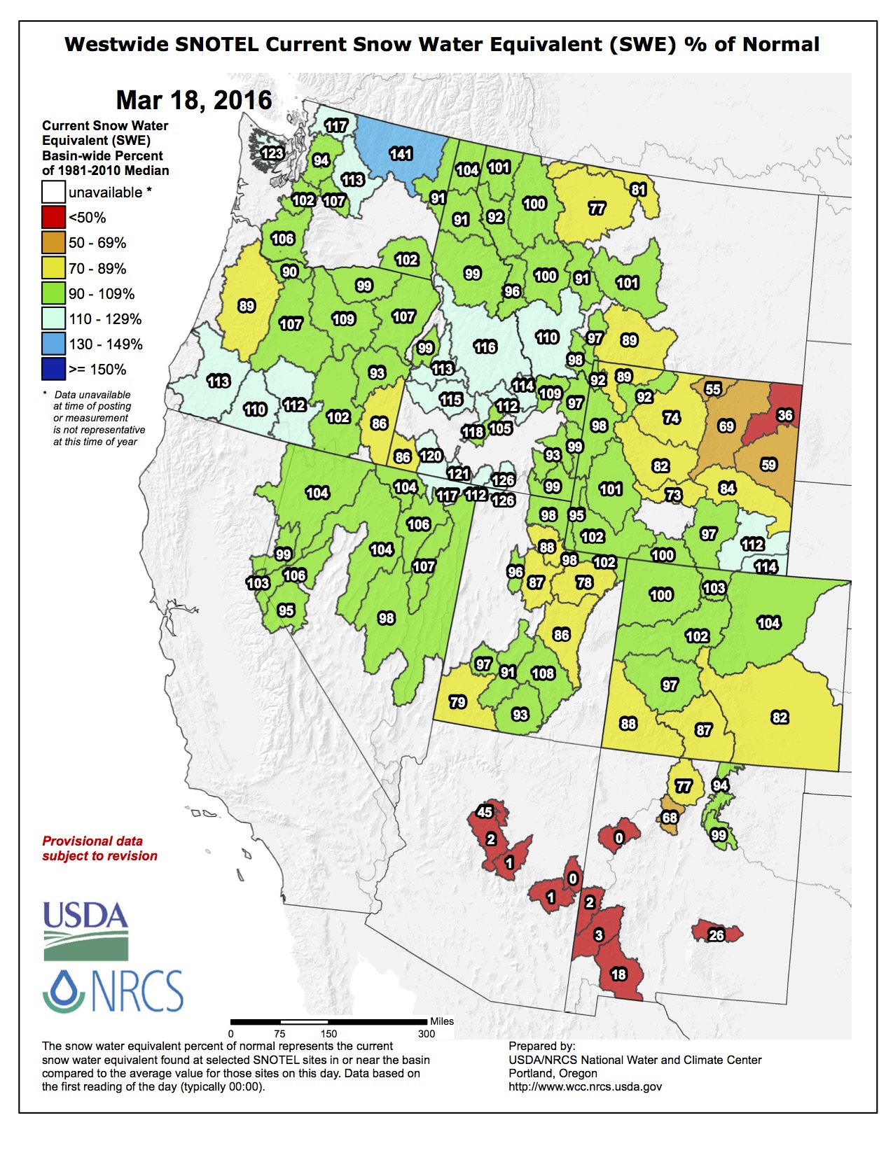
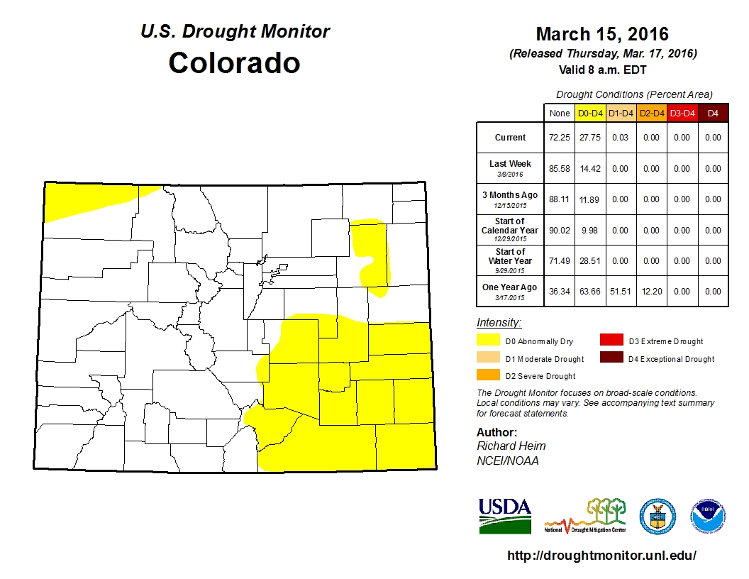
According to the NRCS, the statewide Snow Water Equivalent (SWE) as of Thursday, March 17, was 95 percent of median levels. That missing 5 percent is not of major concern, so long as future weather conditions stay consistent.

“At this point, we are more and more confident as the days go by that we’re in pretty good shape as far as snowpack from a streamflow standpoint,” said Wetlaufer. “If the proverbial faucets turned off right now and there was no more snowpack, then we’d see lower levels. But it’s pretty likely that we’ll continue to get more precipitation in next month or so, and it’s looking encouraging.”

[…]

Heavy snowpack years — which the state could still be heading toward depending entirely on how the rest of the winter and spring weather materializes — actually result in oversupplies of water and is ideal. Those circumstances help establish higher water levels in many of these major headwaters that all leave the state, the Platte, Rio Grande and Arkansas, aside from the Colorado, and are a benefit to all states that utilize these sources.

“In general, a surplus leads to a lot less disagreements in the long run,” said Wetlaufer, “as opposed to a year where we are below normal, which is when those issues get a lot more contentious and people want to make sure they get their fair share. This year seems to be a pretty near-normal snowpack, especially around Summit County, and we should be in good shape for an ample water supply … and in a good place overall.”

From The Denver Post (Jesse Paul):

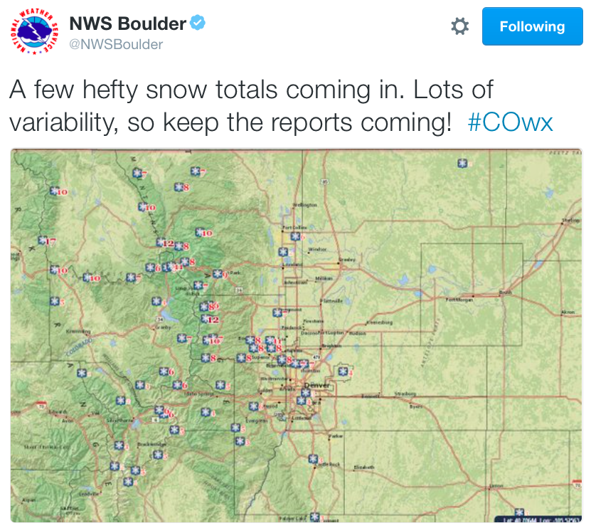
In the past 72 hours, 20 inches of snow has fallen at Loveland Ski Area and Arapahoe Basin. Eldora Mountain Ski Resort tops the charts, reporting 32 inches of new snow during that period…

Winter Park Resort says it has gotten some 45 inches of new snow in the past seven days.

Vail is reporting 27 inches of new snow in the last week while Aspen Snowmass said it has gotten 18 inches over than span.

snowtotalsthru03182016nwsboulder

#Drought news: Abnormal dryness creeping across southeast Colorado — The Denver Post

Colorado Drought Monitor March 15, 2016

From The Denver Post (Jesse Paul):

A U.S. Drought Monitor report released Thursday showed most all of El Paso County and all of Pueblo County enveloped by pre-drought conditions.

“In southeast Colorado, hot temperatures (and) strong winds were drying out soils and sending crops downhill fast, and numerous range fires were also occurring,” the report said.

Just over a quarter of the state, including eastern Washington County and extreme northwest Colorado, were listed as being abnormally dry.

In June, the monitor reported drought and abnormal dryness had been eliminated from southeastern Colorado after years of dry conditions there.

That news followed a May report from the National Weather Service reducing the southeast’s drought classification to “abnormally dry” from “extreme.”

#AnimasRiver: Meeting to discuss #GoldKingMine spill March 28 in Farmington

From The Farmington Daily Times:

The Citizens’ Advisory Committee of the Gold King Mine spill’s long-term impact review team will meet with the community at 5:30 p.m. Monday, March 28 in the Suns Room of the Henderson Fine Arts Center at San Juan College, 4600 College Blvd.

The committee consists of 10 volunteers from northwest New Mexico who work to get information about the spill to the community. It is part of a review team created by Gov. Susana Martinez in August to investigate potential impacts the mine spill could have on the community.

During the meeting, Kevin Lombard, an associate professor at New Mexico State University, and Bonnie Hopkins, an agricultural agent for the San Juan County Extension Office of New Mexico State University, will present information about agriculture and irrigation ditches in San Juan County, according to a press release from the New Mexico Environment Department. They will discuss safeguards that can be taken in light of heavy metal residues that were left in the watershed after the August mine spill.

The public will also have an opportunity to comment during the meeting.

People can view the New Mexico Environment Department’s long-term monitoring plan at http://www.NMEDRiverWaterSafety.org.

This image was taken during the peak outflow from the Gold King Mine spill at 10:57 a.m. Aug. 5. The waste-rock dump can be seen eroding on the right. Federal investigators placed blame for the blowout squarely on engineering errors made by the Environmental Protection Agency’s-contracted company in a 132-page report released Thursday [October 22, 2015]

CWCB board meeting recap: 11 grants = $734,000

From The Pueblo Chieftain (Chris Woodka):

Arkansas River issues took center stage at this week’s meeting of the Colorado Water Conservation Board at Otero Junior College.

The board awarded 11 grants totaling $734,000 to projects in the Arkansas Valley, while touring some other projects in the La Junta area that already are underway. It also reviewed the progress of a pilot program by the Arkansas Valley Super Ditch, which was authorized under legislation in 2013 and heard plans by the Lower Arkansas Valley Water
Conservancy District to introduce new water banking legislation.

Diane Hoppe at CFWE President's Award Reception 2012
Diane Hoppe at CFWE President’s Award Reception 2012

The board paused for about an hour Wednesday to remember Diane Hoppe, who chaired the board until her death last month. Hoppe was a former state lawmaker who had been active in state water issues for more than 30 years.

On Tuesday, the CWCB staff and board toured the Catlin Canal, a channel-clearing project at North La Junta and a flume-replacement project on the Fort Lyon Canal.

The Catlin project is overseen directly by the CWCB under HB1248, which allows the state to do administrative water transfers without changThe Lower Ark district is championing the Super Ditch as a way to allow farmers to keep water rights while leasing some water to cities.

In the Catlin project, river flows are augmented by releases of water stored in Lake Pueblo and recharge ponds that have been built on farms. Cropland is dried up for no more than three years in 10, and the water is leased to Fowler, Fountain and Security.

At Wednesday’s session, Lower Ark attorney Leah Martinsson explained new legislation that would expand the concept to allow the CWCB to administer small transfers of water through a new kind of water bank. Past efforts to establish water banks relied on storage, while the new concept would allow direct flow rights to be leased.

“This is a different kind of tool,” Martinsson said. The bill, not yet numbered, would be sponsored by Democrat Reps. Jeni Arndt of Fort Collins and Ed Vigil of Fort Garland and Sen. Larry Crowder, R-Alamosa.

Like HB1248, the new law would put a 3-in-10 year limit on dry-ups, require approval by the state engineer and prohibit transfers out of basin. It would rely on court-approved rules to allow transfers, but would not create a new kind of water right. It covers small transfers over a 10-year period to avoid large-scale speculation, Martinsson said.

The draft bill released to the CWCB is 19 pages long and fairly complex. CWCB member Patricia Wells asked whether the board would be expected to review many small transfers using such complicated criteria.

Martinsson replied that the rule-making process and ongoing review by the state engineer would simplify the process.
Peter Nichols, Lower Ark and Super Ditch attorney, said the proposed water bank would be more useful to farmers than existing statutes, giving them flexibility without altering water rights.

“It’s a better way to do this,” Nichols said. “It adds rigor to the process without going to water court for major changes.”

Meanwhile, the CWCB awarded a grant to study flood control on Fountain Creek. Here’s a report from Chris Woodka writing for The Pueblo Chieftain:

Visions, studies and arguments over flood control on Fountain Creek have consumed attention in El Paso and Pueblo counties for the past decade.

Real work may finally be just around the corner — give or take a few bad floods.

The Colorado Water Conservation Board gave its approval this week to a $41,800 grant that will be added to $37,500 in local funds to begin evaluating potential sites for a dam or other flood control structures on Fountain Creek between Colorado Springs and Pueblo.

Like the creek itself, getting even to this point has been a meandering process, hitting snags and jumping out of the channel, as Larry Small, executive director of the Fountain Creek Watershed Flood Control and Greenway District explained to the CWCB.

“We first chose two scenarios to move forward,” Small said, explaining that a U.S. Geological Survey studied identified a dam or series of detention ponds between Fountain and Pueblo as the best way to protect Pueblo from intermittent flooding. “The water rights protection task came first.”

After a study last year confirmed flood control on Fountain Creek could be attained without harming water rights, the district moved to the next step of identifying where structures might be located. The existing study by the Army Corps of Engineers is limited to big projects and more than 40 years out of date.

The water rights issue doomed an earlier grant request at the Arkansas Basin Roundtable. Since then, the state Legislature passed a law that allowed storage of flows for flood control for up to 72 hours, except on Fountain Creek. The Fountain Creek district completed its study of water rights last year, however, and it passed roundtable scrutiny.

“We resolved the differences between stakeholders,” Small said. “It showed that water rights are a top priority in future projects.”

The preliminary work is needed as the Fountain Creek district prepares to receive $50 million over a five-year period specifically for flood control projects to protect Pueblo. The district is looking at the money to leverage more funding that would be needed to complete at least $150 million in projects already identified in plans.

The $50 million is a condition of a 1041 permit issued by Pueblo County for construction of the Southern Delivery System pipeline from Pueblo Dam to the El Paso County line.

Fountain Creek erosion via The Pueblo Chieftain