Upper Colorado River Endangered Fish Recovery Program
FromThe Grand Junction Daily Sentinel (Dennis Webb):
Ute Water manager lauded for leadership: Endangered fish will benefit from efforts to improve water levels
The head of the Ute Water Conservancy District is being honored by a Colorado nonprofit agency for his leadership in leasing association water to benefit endangered fish.
Larry Clever, Ute Water’s general manager, is receiving the David Getches Flowing Waters Award from the Colorado Water Trust, a nonprofit group dedicated to using market-based transactions to restore and protect flows on Colorado’s rivers. He will receive the award in Denver on June 14 at RiverBank, the nonprofit group’s annual fundraising event.
The honor derives from Ute Water’s decision last year to lease water from Ruedi Reservoir above Basalt to the Colorado Water Conservation Board to benefit endangered fish in what’s known as the 15-mile reach of the Colorado River upstream of its confluence with the Gunnison River. The board ended up using 9,000 acre-feet under the deal.
The entities have agreed to renew the lease this year. The deal involves water that serves as a backup supply for Ute Water and a source to meet potential new demand.
Clever described the lease as “kind of a joint idea” between him, assistant manager Steve Ryken and Ute Water attorney Mark Hermundstad. It involves water that Ute Water contracted for in 2013 from the Bureau of Reclamation reservoir.
“What we wanted to do was get the water to Lake Powell so we could increase the water level in Lake Powell. This was a mechanism to get it there,” Clever said of the deal with the water conservation board.
Ute Water is concerned about the potential for levels in Powell to fall low enough to threaten hydroelectric power generation at the reservoir or to jeopardize the ability of upstream states in the Colorado River Basin to meet water delivery obligations to downstream states. Either situation could result in restrictions on Upper Basin water use.
“We had this water sitting in Ruedi and the idea was to get it into Lake Powell just so we could raise the water level a little higher,” Clever said.
It’s not very much water compared to Powell’s size, he conceded.
“But it’s better than not putting anything in it, and the fish definitely benefit,” he said.
The 15-mile reach is critical habitat for four endangered fish — the Colorado pikeminnow, razorback sucker, humpback chub and bonytail. Low flows in late summer can stress the fish.
The award Clever is receiving is named for a man who helped found the water trust, served as executive director of the Colorado Department of Natural Resources, advised the Interior secretary during the Clinton administration, and served as dean of the University of Colorado School of Law.
“If people for whatever motivations want to put more water back in rivers, that is close to sort of David’s vision for Colorado and ours as well,” said Zach Smith, staff attorney for the trust.
He said the deal involving Ute Water, making use of water in upstream reservoirs that isn’t needed in a particular year, is the kind the trust would like to see more of.
Hannah Holm, coordinator of the Hutchins Water Center at Colorado Mesa University, said that Ute’s action “demonstrates a proactive, creative approach to providing long-term water security for Ute customers while also taking tangible steps to address regional water challenges.”
From the Hutchins Water Center (Hannah Holm) via The Glenwood Springs Post Independent:
The “use it or lose it” feature of Colorado water law is often blamed for discouraging farmers and ranchers from taking efficiency and conservation measures that could benefit the environment or ease the supply/demand imbalance on the Colorado River. However, a report released in February by the Colorado Water Institute argues that misinterpretations of the law are a bigger disincentive than the law itself.
The report was developed as a result of in-depth discussions by a panel of stakeholders and experts that included Colorado State Engineer Dick Wolfe, who directs the office that administers water rights. Wolfe presented the report at a forum on the future of irrigated agriculture in Delta on May 3, and Colorado River District Counsel Peter Fleming presented the report at the Mesa County State of the River meeting in Grand Junction on May 13.
The report concludes that diverting more water from a stream than crops actually use does not expand a water right. In addition, the report explains that recent laws allow irrigators to cut their water consumption without diminishing their water rights if they are participating in certain water conservation, fallowing and leasing programs.
Maximizing diversions doesn’t maximize the value of a water right.
The report notes that while an agricultural water right may be written in terms of a certain quantity of water that can be diverted from a stream in order to irrigate a particular parcel of land, the actual value of the water right is based on how much water is consumed by crops. A farmer who sells a water right to a city can only sell the right to use the amount that has historically been consumed by crops.
Rights to use quantities of water that historically leaked from a ditch or otherwise seeped back into the stream can’t be sold, because others downstream may rely on that water. Efficiency improvements, like lining ditches or switching from flood to sprinkler irrigation, which allow the same acreage to be irrigated with a smaller diversion from the stream, therefore should not diminish the transferable value of a water right.
Protecting water rights from abandonment
The Colorado Division of Water Resources can put water rights on the abandonment list for termination if the rights haven’t been used for 10 years, but the water right holders can avoid termination of the rights by showing that they don’t intend to abandon them. The report states that using measuring devices and keeping good records of water diversions and use, as well as “special circumstances” such as damaged infrastructure or participation in a conservation program, are more effective ways to protect a water right than maximizing diversions.
Conservation and leasing programs allow use cuts without diminishing rights
Recent laws protect water right holders from having the value of their water rights diminished as a result of cuts in use through certain leasing, conservation and fallowing programs. These include Senate Bill 13-019, which decrees that for water rights in the Colorado, Gunnison and Yampa/ White basins, decreases in use as a result of participating in federal land conservation programs or approved water conservation, land fallowing and water banking programs for up to five years in a 10-year period won’t decrease the value of the water right. Rotational crop management programs and loaning or leasing water to the Colorado Water Conservation Board to enhance stream flows also allow for reductions in water use without reductions in the value of a water right.
Hannah Holm is coordinator at the Hutchins Water Center at Colorado Mesa University.
Flood irrigation in the Arkansas Valley via Greg Hobbs
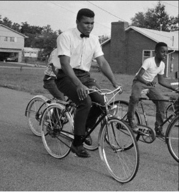
“Why should they ask me to put on a uniform and go 10,000 miles from home and drop bombs and bullets on Brown people in Vietnam while so-called Negro people in Louisville are treated like dogs and denied simple human rights? No I’m not going 10,000 miles from home to help murder and burn another poor nation simply to continue the domination of white slave masters of the darker people the world over. This is the day when such evils must come to an end. I have been warned that to take such a stand would cost me millions of dollars. But I have said it once and I will say it again. The real enemy of my people is here. I will not disgrace my religion, my people or myself by becoming a tool to enslave those who are fighting for their own justice, freedom and equality. If I thought the war was going to bring freedom and equality to 22 million of my people they wouldn’t have to draft me, I’d join tomorrow. I have nothing to lose by standing up for my beliefs. So I’ll go to jail, so what? We’ve been in jail for 400 years.” — Muhammad Ali via Wikiquote.
“My conscience won’t let me go shoot my brother, or some darker people, or some poor hungry people in the mud for big powerful America. And shoot them for what? They never called me nigger, they never lynched me, they didn’t put no dogs on me, they didn’t rob me of my nationality, rape and kill my mother and father… Shoot them for what? How can I shoot them poor people? Just take me to jail.” — Muhammad Ali via Wikiquote.
Ali and his deep wisdom inspired me in those formative years in the 1960s when I was a teenager in Denver. He gave up his championship and freedom in opposition to the Vietnam war. I remember the racially charged statements about his purpose for refusing and the hatred many had for him at the time. I didn’t serve in the Vietnam war and I know that Ali’s leadership in opposition to the war caused me to question the purpose of that war and war in general.
I loved his example, train hard, prepare harder, don’t lose sight of the goal, don’t compromise your principles or your humanity. Work to make the world a better place.
What a loss to suffer, even if for years you knew it was coming. Muhammad Ali, who died Friday, in Phoenix, at the age of seventy-four, was the most fantastical American figure of his era, a self-invented character of such physical wit, political defiance, global fame, and sheer originality that no novelist you might name would dare conceive him. Born Cassius Clay in Jim Crow-era Louisville, Kentucky, he was a skinny, quick-witted kid, the son of a sign painter and a house cleaner, who learned to box at the age of twelve to avenge the indignity of a stolen bicycle, a sixty-dollar red Schwinn that he could not bear to lose. Eventually, Ali became arguably the most famous person on the planet, known as a supreme athlete, an uncanny blend of power, improvisation, and velocity; a master of rhyming prediction and derision; an exemplar and symbol of racial pride; a fighter, a draft resister, an acolyte, a preacher, a separatist, an integrationist, a comedian, an actor, a dancer, a butterfly, a bee, a figure of immense courage.
Here’s an obit from The New York Times (Robert Lypsyte).
How people enjoy and use the Arkansas River between Leadville and Lake Pueblo will be the focus of state and federal officials as they update the Arkansas Headwaters Recreation Area management plan.
Of course, the public’s input is encouraged. Public comment on three alternative management plans will be accepted through June 22.
With Alternative 1, use would be increased to a small degree, while Alternative 2 would allow increased use to a much larger degree. Alternative 3 would keep use as it is now without change, according to Kyle Davidson, a spokesman for Colorado Parks and Wildlife.
Public input will help representatives with the U.S. Bureau of Land Management, U.S. Forest Service and Colorado Parks and Wildlife develop an environmental assessment, which will include a preferred alternative. It should be available for further public scrutiny this fall.
Essentially, the management plan is a blueprint for how the agencies will manage the 152-mile river corridor and find balance between often-conflicting recreational uses such as rafting and fishing. The Arkansas is the most commercially rafted river in the U.S. and also is home to a Gold Medal Trout fishery.
The recreation area consists of 45 recreation sites, including six campgrounds, 26 boat ramps and 18 developed facilities. About 800,000 visitors use the river corridor each year.
The partnership also is eyeing how it will manage river-based recreation through the newly dedicated Browns Canyon National Monument.
The current management plan can be reviewed at http://cpw.state.co.us/placestogo/parks/ ArkansasHeadwatersRecreationArea/ Pages/publications. aspx. To submit a comment visit cpw. state.co.us/placestogo/ parks/ArkansasHeadwatersRecreationArea/ Pages/default. asps.
From the National Geographic Voices blog (Sandra Postel):
“I don’t know what I pump and I don’t care – and that’s crazy,” says Paul Schwennesen, a fit, energetic rancher in his late thirties who might outcompete Clint Eastwood for most handsome cowboy.
On his modest-size ranch, the Double Check, located in the lower San Pedro River Valley of southeastern Arizona, Schwennesen raises cows to supply grass-fed beef to farmer’s markets and seventeen restaurants in Phoenix and Tucson, both cities about an hour-and-a-half away. Schwennesen’s ranch abuts one mile of the San Pedro, and, as an irrigator, his pumping of groundwater contributes to the depletion of the river’s base flow, the current that keeps the river wet and connected during the dry season.
In contrast to most irrigators in the West, Schwennesen wants to be made to care how much groundwater he pumps. A decade ago, he took over operations at Double Check from his father, who now raises cattle in the high country near the Arizona-New Mexico border. Schwennesen is a successful rancher and businessman, but cares about the river, too. In his mind, free water is no friend to the river or the long-term health of the community, and he wants to see water better valued.
“I am a free-market devotee,” Schwennesen said. “Markets are the best way to allocate scarce resources. We’d love to see a market established for water.”
Schwennesen is among a new cadre of farmers and ranchers that brings a more holistic, ecological way of thinking to land management.
“Water is the salient variable in these environments,” he said, as we examined one of his experimental fields on a warm, late-May morning. “Anything you can do to alter the water regime is going to have the biggest effect. And the more organic matter we can squeeze back into the soil, the more water.”
It’s a belief backed by science, and it’s at the core of Schwennesen’s mission. “Well managed land can give back more than it consumes,” he added. “That’s the miracle of it.”
I’ve come to the Double Check smack in the middle of the driest time of the year, typically April to June. The much anticipated El Niño of 2015-16 did not deliver the rains most had hoped for. Just a short distance from where we stood talking, the San Pedro’s channel was dry. Historically this portion of the lower river had flowed intermittently, but over time groundwater pumping and prolonged drought have depleted the base flow and dried up the channel, a condition that’s bothersome to Schwennesen.
The San Pedro is the last major undammed river in the American Southwest. Unlike the Colorado River and the Rio Grande, which flow south toward Mexico, the San Pedro originates in Mexico and flows north some160 miles before joining the westward flowing Gila River near the small town of Winkelman.
It is a winding ribbon of green in the desert that offers biological riches far out of proportion to its size. The gallery forests of cottonwoods, willows and mesquite that band both sides of the river provide some of the best remaining habitat for birds and wildlife in the American Southwest.
More than three hundred species of migratory songbirds seek out the San Pedro corridor as they journey between their wintering grounds in Central America and Mexico and their breeding grounds in the United States and Canada. More than fifteen percent of the world’s known population of western yellow-billed cuckoo breeds along the San Pedro. The river system also sustains some eighty species of mammals – one of the richest assemblages of land mammal species found anywhere in the world – as well as more than forty species of reptiles and amphibians.
For such a modest river, its ecological wealth is extraordinary. But irrigated agriculture, copper mining, and in the upper reaches of the valley, urban growth have placed that wealth in jeopardy. Without the ability to reduce groundwater use and keep the river healthy and flowing, the San Pedro’s bounty and beauty will be sacrificed.
That’s where Schwennesen comes in. He has partnered with the Tucson-based Arizona Land and Water Trust and hydrologists at the University of Arizona to see if he can ranch successfully and profitably while cutting his water use by some 20-30 percent. The strategy is to shift to low water-use crops that include a mix of native perennial grasses and an annual rye crop that is seeded directly into the green vegetative cover, avoiding the tillage action that can erode and dehydrate the soil.
With deep and resilient root systems and microbial activity boosting the level of organic matter, the soil should hold water like a sponge, Schwennesen says, reducing the need for irrigation water and helping to replenish the aquifer that feeds the river’s base flow.
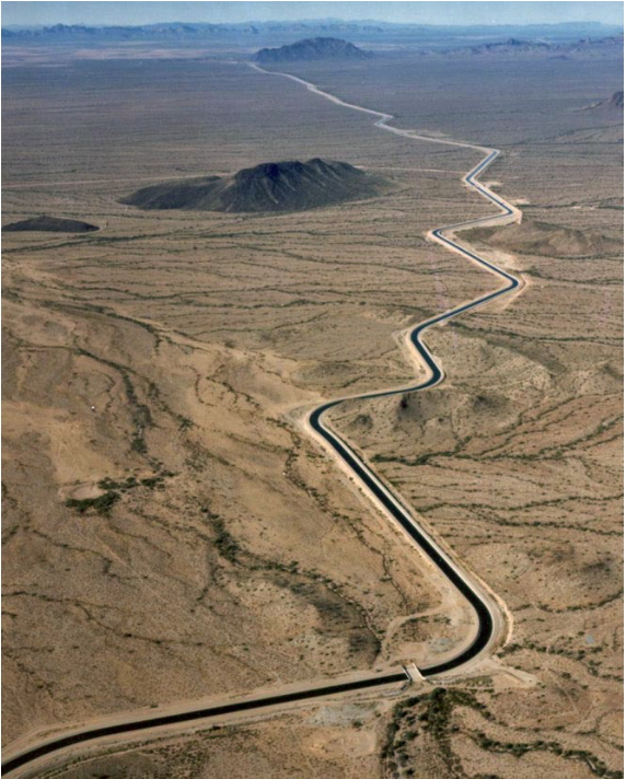
The Central Arizona Aqueduct delivers water from the Colorado River to underground aquifers in southern Arizona. UT researcher Bridget Scanlon recommends more water storage projects like the aqueduct to help protect against variability in the river’s water supply. U.S. Bureau of Reclamation.
Here’s the release from the Central Arizona Project:
To know the quality, you need to visit the source. That’s the case with CAP water – to know the quality, you need to look to the Colorado River. Back in 1975 – more than 40 years ago – the seven Colorado River Basin states adopted an EPA-approved salinity standard for the Colorado River. This standard provides criteria for dissolved solids and a plan designed to keep the average annual salinity concentrations at or below 1972 levels. Salinity control is important because increased salt levels can limit or prohibit agricultural productivity and add costs to municipal and industrial water users. All Colorado River water users benefit from investments in improved water quality, including those in Mexico.
The Colorado River Salinity Control Program is managed by a partnership of federal and state agencies that have worked cooperatively with tribal communities, irrigation companies and individual water users for the past four decades to control the salinity levels of the Colorado River, while allowing development and use of its waters. CAP represents Arizona water users on the Salinity Control Forum along with the Arizona Department of Water Resources and the Arizona Department of Environmental Quality. Through efforts to date, the salt load of the Colorado River has been reduced by about 1.3 million tons annually. The current plan calls for the creation of an additional 67,000 tons of annual salinity control practices over the next three years.
Today, the Colorado River currently meets all applicable water quality standards, but the challenge in an era of drought is to protect and maintain that quality going forward. To meet this challenge, CAP, the Metropolitan Water District of Southern California and Southern Nevada Water Authority joined together in 2011 to form the Lower Colorado River Water Quality Partnership. The Partnership works to identify and implement proactive, collaborative solutions to address Colorado River water quality by identifying the challenges currently facing the River, collaborating on research and policy analysis and developing initiatives and solutions to ensure the River’s future health and sustainability.
The Partnership recognizes the importance of collaborating on current Colorado River water quality issues and participating in ongoing monitoring and clean-up efforts to maintain the integrity of the Colorado River. The Partnership has closely monitored various remediation efforts throughout the Colorado River Basin and advocated for expeditious clean-up. The Partnership has also reviewed and commented, as needed, on project proposals, including regulatory and legislative project developments, to minimize potential threats to water quality in the Colorado River.
A screenshot from the website for Colorado’s Water Plan.
Here’s a guest column from Nita Gonzales and Al Gurule that is running in The Colorado Springs Gazette:
Colorado’s large Latino population relies on our rivers for drinking water, jobs, outdoor recreation and crop irrigation. Our voices and values are similar to the vast majority of Coloradans. But for Latinos, the river and the land it nurtures is also a very personal matter. For centuries, the river provides our culture with a collective sense of “querencia,” a place in which we know exactly who we are, the place from which we speak our deepest beliefs.
When the Colorado Legislature ended its session there was a flurry of action but, sadly, little progress to protect our rivers. The subject of water was barely covered, and perhaps most remarkably, taking action on Colorado’s first state water plan – the blueprint for how water will be managed in Colorado for the foreseeable future – was limited to a small, generic “projects” appropriation.
The landmark water plan, released last year, addresses many water challenges facing our state including: a looming water supply and demand gap, the effects of persistent drought, protecting Colorado’s interstate water rights, and other challenges that could adversely affect the lives of Coloradans.
Gov. John Hickenlooper’s plan includes an unprecedented emphasis on sound conservation measures and directs attention to keeping the Colorado River healthy and flowing. Latinos in Colorado pay close attention to the protection of the Colorado River system, the primary source of water for Colorado and the southwestern U.S. and a significant part of southwestern Latino culture. For Latinos living in the Southwest, protecting this river is more than just smart water management; it is honoring part of a rich cultural heritage.
The lack of engagement on the water plan by the state assembly is surprising and unfortunate. After all, a great deal of care and thoroughness went into our state plan, including input from 30,000 Coloradans. It’s been rightly hailed as a huge step for Colorado’s future water management.
The final plan includes key priorities directly in line with western Latino values for water management:
– A productive economy that supports agriculture, recreation and tourism;
– An efficient and effective water infrastructure; and
– Healthy watersheds, rivers, streams, and wildlife.
The plan includes strong recommendations for funding to preserve and restore the state’s rivers and streams that play an important role in Latino history and daily life. It contains a directive that Colorado invest in unprecedented stream protection and restoration in the form of “stream management plans” for our rivers.
The only real obstacle, at this point it seems, is lack of leadership and action and letting the plan languish, and that is what appears to be happening.
To ensure that the conservation values included in the plan move forward – protecting healthy river flows, our outdoor recreation industry, agricultural heritage, businesses and thriving cities – we must get started now. Gov. Hickenlooper and the Colorado Water Conservation Board should begin working with local leaders to find innovative ways to meet the plan’s ambitious – but attainable – conservation goals. In the latest Colorado College poll, 77% of Coloradans say that we should use existing water resources more efficiently through conservation and reuse.
Nuestro Rio and other Latinos in Colorado are ready to work with Hickenlooper and state leaders to implement the conservation values laid out in the plan. We want to help ensure the protection of our rivers, outdoor recreation, agriculture, industry and our cities.
We ask the governor and the Colorado Water Conservation Board to take meaningful action to implement the plan without additional delays. The time is now to ensure Colorado’s water, our economy and our culture is sustainable for generations to come. We are depending on it.
–
Nita Gonzales is the director of Nuestro Rio, an organization representing Latinos living in Arizona, California, Colorado, New Mexico and Nevada working to educate elected officials and Latino youths about the many ways Latinos are connected to the Colorado River. Al Gurule is a former Pueblo District 2 councilman and a well-known Latino activist in Colorado since the late 1960s.
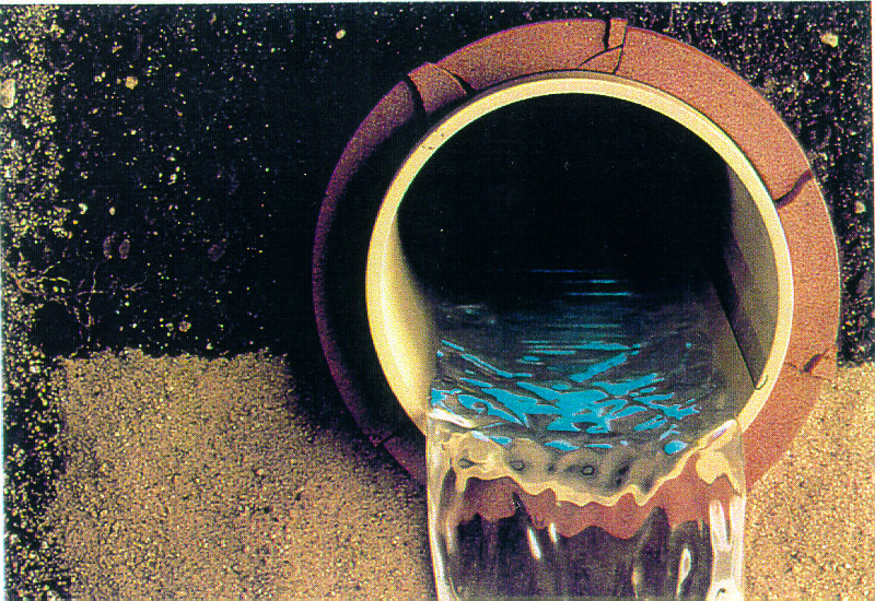
In the next 10 years, Pueblo will have $56.7 million additional costs to treat wastewater, according to information presented in a recent City Council work session.
More than half of that will occur because of a $31.5 million program to line pipes to keep groundwater out of the sewer system. The option is less expensive than trying to remove selenium at the wastewater treatment plant.
The other $25.2 million is for increased chemical and electricity costs to remove nutrients.
More costs could arise as regulations continue to change.
In December, council approved rate increases of about $3 per month to begin covering the costs. For a home billed for 4,000 gallons of sewage monthly, the total amount is $28.67.
By 2020, the rate will increase to $43.49 per month, with $7.60 of that attributable to the selenium program. The city is spending $1 million to line pipes this year, $2 million next year and $3.5 million each year thereafter to complete the process in 10 years.
The Colorado Water Quality Control Commission in December extended a temporary modification for Pueblo, but said a discharger specific variance is needed by June 2018. At that time, Pueblo will have to present its plan for complying with a numeric limit for selenium discharges from its wastewater plant.
More coverage from Chris Woodka writing for The Pueblo Chieftain:
Pueblo couldn’t kick its selenium habit no matter how hard it tried.
Selenium, a natural occurring element that can be toxic at high levels, is loaded into surface water and groundwater as it comes into contact with Pierre shale formations on Wild Horse Creek and Fountain Creek.
But Pueblo’s sewage treatment plant is under the gun to meet state standards within two years, before it is able to prove its point that water leaving the plant actually reduces the selenium that enters the Arkansas River.
What’s more disturbing is that a $31.5 million experimental program to reduce selenium in wastewater lines might actually increase the amount that reaches the river.
The issue has become a matter of contention between Councilman Chris Nicoll and Commissioner Terry Hart, who face off for Hart’s seat in the June 28 Democratic primary. Nicoll says Hart led legal opposition to the city’s case before the state Water Quality Control Commission. Hart says the county pulled out before the state’s eventual decision.
The city was trying for a 10-year path toward a solution, but was given just two years to come up with a plan.
“The wastewater plant is responsible for 6 percent of the selenium loading into the river,” said Pueblo Wastewater Director Nancy Keller. “We could take out 100 percent, and have no impact.”
In many cases, selenium could wind up in wastewater because of industrial processes. In Pueblo, it occurs naturally.
Groundwater containing selenium enters the wastewater system through cracks or holes in mostly clay pipes that are 75-100 years old. The holes are mainly on the top portion of the pipes, because connections over the years have been made by knocking a hole in the pipe and sticking another pipe into it, Keller said.
Unlike water service lines, the sewage lines are under gravity flow, which means that during dry times, the water is unlikely to leak out, although there could be some cracks in the bottom of the line, she said.
But during wet times, the concentration of selenium increases in all types of water, and groundwater rises and puts pressure on the pipes, infiltrating the sewer system.
The city is lining pipes in the western part of Pueblo, where selenium is most prominent. Levels in the groundwater reach up to 8,000 parts per billion in one test well — more than 500 times the stream standard of 14.1 ppb.
During dry to moderate times, the release level from the city’s wastewater plant is between 12-20 ppb.
“If we have a storm, it will go up to 60 ppb,” Keller said. “Yet even when we’re high, the river is higher yet.”
According to scientific studies, the toxicity of selenium in Pueblo’s water is counteracted by sulfates, which are naturally occurring in the same geologic formation, Keller said. No evidence of widespread harmful impacts can be found.
Pueblo is in the process of lining sewer lines and manholes on the West Side, and evaluating the impact. But that will take 10 years to complete, and the state Water Quality Control Commission has set a two-year deadline to develop a numeric standard, called a discharger specific variance, for Pueblo’s wastewater plant.
“The tests we’re doing will have some impact, but there won’t be enough data,” Keller said. “You need a wet period, but don’t know if we’ll get it. We won’t have enough data to make everyone comfortable.”
Click here to go to the US Drought Monitor website. Here’s an excerpt:
Summary
The past week’s weather brought about a mixed bag of changes to the U.S. Drought Monitor map, with expansion of dryness and/or drought noted in the Northeast, Southeast, upper Great Lakes, northern Plains and Pacific Northwest. The most notable expansions this week are the advancement of D0 across the northern Cascades in Washington up to the Canadian border and the expansion of D0-D1 and a new area of D2 in the Southeast centered over northern Georgia, northern Alabama and southern Tennessee. For the most part, unseasonably warm temperatures were found east of the Rocky Mountains (with the exception being California), particularly in the Midwest, Upper Great Lakes and Northeast, where readings ran 5-15 degrees above the norm. On the other side of the spectrum, cooler-than-normal temperatures were observed across much of the West as Mother Nature always seems to find a way to balance the scales…
The Plains
Again, heavy rains pounded eastern Texas, parts of eastern Oklahoma and eastern Kansas. Recent rains have also led to the trimming or removal D0 across western Texas and the Texas Panhandle. Farther north, recent dryness and more seasonable temperatures have led to an expansion of D0 in western South Dakota and into northeastern Wyoming. Rains in northwest North Dakota and parts of eastern North Dakota have led to the reduction of D0 there…
The West
Most of the changes on this week’s map were for the better, with the one exception being the northern Cascades in Washington, which saw a push of D0 conditions north to the Canadian border. Elsewhere, D2 has been removed from the Big Horn range in Wyoming given the more favorable weather of late, but D0-D1 still remains as we head into summer. Some minor reduction of D0-D1 was also made in northwestern Montana this week, but lingering long-term water supply impacts remain. Other areas seeing changes for the better can be found along the eastern and southern flanks of the drought across western Nevada, extreme southeastern California, northwestern Arizona and southwestern Utah. Although certainly not all in the clear, northwestern California has seen some minor reduction of D0-D1…
Looking Ahead
The NWS WPC 7-Day Quantitative Precipitation Forecast (QPF) (June 1-8, 2016) is showing a very dry week on tap west of the continental divide. Heavy rains are expected in the southern Plains, Michigan’s Upper Peninsula, southern Florida, the middle Appalachians and New England. The West will also warm up under some strong ridging as temperatures are expected to be running 6-18 degrees above normal for this time of year. Cooler weather should persist over this period in Texas, the Midwest, the Mid-Atlantic and the Northeast.
Under strong model and forecast tool agreement, CPC’s 6-10 day outlooks are showing a strong ridge building in the West and extending into the central and northern Plains. Temperatures here will likely be running well above normal for the period June 7-11. Temperatures across Alaska and the Southeast also look to be above normal while the Northeast is most likely to experience below-normal temperatures during this time frame. As for precipitation, the odds are tilted toward above-normal totals in Alaska, the Pacific Northwest, the northern Great Basin and northern New England. The odds are not looking good in the central and southern Great Plains, Midwest, Gulf Coast region (except for southern Florida), and Mid-Atlantic, with rainfall looking likely to be below normal through early June.
FromThe Cortez Journal (Jim Mimiaga) via The Durango Herald:
A whitewater boating release below McPhee Dam will begin at 1 a.m. Friday and last at least three days.
Flows will be ramped up to at least 800 cubic feet per second by early Friday morning, and will remain at that level through Sunday, June 5.
Reservoir managers said the recreational release could lengthen, and flows may go higher as the reservoir fills and water is sent downriver.
The spill was delayed until warm weather brought the runoff forecast into focus.
A peak is expected in June on the Upper Dolores River as mountain snowpack melts.
It takes a few hours for release to reach the Bradfield Bridge put-in and other boat ramps.
The release will taper off late Sunday, ramping down from 800 cfs to 600 cfs over two days. From there, the river will drop down to 400 cfs over two days, then 200 cfs and finally 65 cfs. Minimum boatable flows for rafts is 800 cfs to 600 cfs; minimum for kayaks flow is 300 cfs to 400 cfs.
Smaller rafts and kayaks could enjoy five to seven days of boating run in the 100-mile canyon below McPhee.
After Sunday, decisions about releases will be posted on the McPhee Reservoir website.
Documentary filmmaker Rig to Flip has been monitoring the Lower Dolores and has identified and photographed a new boulder field and rapid upstream of the Dove Creek pump house and boat ramp.
Around the newsroom, John Fleck used to be called The Harbinger of Doom. When drought overtook New Mexico more than a decade ago, his stories regularly started running with headlines like: “New Mexico in its worst drought since 1880s,” “Conflicts rise as water dwindles,” and “San Juan water dries up for first time in 40 years.”
Initially covering science and the national laboratories, Fleck didn’t take over the water beat at the Albuquerque Journal until New Mexico was well into its most recent drought. “I was geared up to write about people running out of water,” he says today, sitting on his back porch and watching doves dip their beaks into a makeshift pond while black-chinned hummingbirds inspect the flowers. In 2013, when wells were running dry in the communities of Magdalena and Maxwell, he’d hit the road with a photographer, then bang out more depressing stories.
But the coverage didn’t feel quite right to him: “I began to realize there was this other story about people not running out of water,” he says.
Locally, for example, he points to a drop in Albuquerque’s water consumption. At the same time, as the city relied less on groundwater pumping and more on water from the Rio Grande, the aquifer started recovering.
“By the end, I was chafing under the constraint of what a newspaper story should be – 600, or maybe 750 words,” he says. Short, to-the-point, and focused on a crisis. In general, newspapers aren’t in the business of peddling stories about complicated issues and the subtle, nuanced solutions people devise.
Despite the nickname, Fleck just isn’t a gloomy guy. The grind of it all began to wear on him.
After three decades of writing short, punchy stories about crisis and conflict, he’s now thinking beyond day-to-day headlines. He’s also crafting deep arguments on how to solve the same problems he reported on before leaving the Journal last year. Today he’s an adjunct faculty member and writer-in-residence in the University of New Mexico Water Resources Program. His latest book, Water is for Fighting Over and Other Myths about Water in the West, publishes in September.
By focusing almost exclusively on failures and crises, he says that newspapers create a gap in the public narrative. Which is too bad, he says: “Positive messages can help people who are otherwise scared and combative about the future.”
Looking outside New Mexico, Fleck found more examples of declining water use—and of people coming together to work cooperatively. “I started to see all these places where, in the midst of the risk of crisis, people are slowly and quietly adapting,” he says. “But that doesn’t get as much attention—because it’s slow and quiet.”
Moving last year from the Journal Center to an office at UNM, Fleck finally found his sweet spot. He no longer had to focus on crisis. And he could turn his attention fully toward a river he’s loved since childhood: the Colorado River, where seven states share water under an agreement signed nearly a century ago.
While researching his book, Fleck started off curious about what happens when there’s not enough water; relying heavily on water stored in reservoirs, by the late 1990s states were using more water than actually flowed through the Colorado annually.
He ended up surprised by how well people work together to avoid a crisis. Reinforcing relationships outside the negotiating room is important, he says. That’s in part because in this new era of scarcity, the old rules and the old battle lines don’t hold up very well.
One story Fleck loves to tell involves a raft and two Colorado River foes: an environmental advocate and the general manager of the Central Arizona Project, which moves more than a million acre-feet of river water through the desert in canals and pipes. Dueling from opposite ends of the water wars, the two had been quoted in the same newspaper articles. But before that rafting trip, they’d never actually met in person. Afterwards, they crafted ways to protect Mexico’s Cienega de Santa Clara from the impacts of a desalination plant. People would still get their water. But an important watershed, one that supports migrating birds and wildlife at the lower end of the Colorado, wouldn’t be destroyed.
A rafting trip—or something simpler, like a drink together at the bar or a shared meal—might not seem like a big deal. But when formal relationships strengthen, evolve, or cross institutional boundaries, Fleck thinks people better understand what the others want and value when they’re sitting around the negotiating table.
As drought has further deepened the gap between water supply and demand on the Colorado, states and water users may be facing dire challenges. And yet, there are flickers of hope within the gloom of crisis.
A celebration of the return of water to the Delta near San Luis Rio Colorado
A few years ago, for example, more than a dozen U.S. and Mexican agencies, as well as environmental groups, cooperated to deliver water to cities and farms during a drought – and also open the gates of Morelos Dam on the U.S.-Mexico border. That pulse of water would mimic the spring runoff rivers naturally experience when their waters aren’t dammed, diverted, and siphoned into taps and irrigation canals. In other words, water managers would allow the lower part of the Colorado to act like a river, rather than just a channel that delivers water for human needs.
It was a historic event. Since the 1960s, the river hasn’t typically reached the sea.
Greedy for water after decades dry, the channel sucked up most of the water before it made it to the ocean. But even after the eight-week long pulse moved through, scientists continued studying how the delta responded: they monitored where plants grew and survived, how that stream side habitat has affected birds and wildlife, and how the return of freshwater affected the groundwater.
With all that information, they’re learning more about the Colorado and its delta—and how future spring pulses or supplemental water releases might help the system and its wildlife even more.
Fleck still grins and waves his arms when talking about watching that water spread and fill the sandy channel two years ago. Activists, scientists, and officials from the US and Mexico peered over the bridge. And in the community of San Luis Río Colorado—a community still named for a river that no longer flowed past—people celebrated the water’s return. Families dragged lawn chairs and coolers to the riverbank. Kids threw up their arms and jumped into the water.
“It was made possible because all these people were working together for years,” Fleck says. “This collection of humans were all excited that they had done something people thought couldn’t be done.”
About a year after tests revealed elevated levels of lead in the town of Berthoud’s drinking water, another round of tests revealed similar results.
The town issued a notice to residents Wednesday that five of 40 samples recently tested for elevated lead levels. Town representatives did not immediately respond to a Coloradoan request for more information about the test results.
Berthoud’s drinking water system has struggled to meet the regulatory standard for lead in drinking water since at least 2014, records obtained by the Coloradoan show. In 2014, the water system had levels double the federal standard of 15 parts of lead per billion parts of water.
In 2015, another round of tests yielded the same result. The town’s water system serves about 5,400 people.
The 15 parts per billion value is a regulatory standard, not a public health standard. [ed. emphasis mine] Lead exposure can cause serious damage to the brain and kidneys and is especially dangerous for infants, young children and pregnant women…
Berthoud is far from the only Colorado community to struggle with elevated lead levels in its drinking water. Nineteen of Colorado’s 64 counties yielded at least one drinking water test result with 15 ppb or more of lead between 2012 and 2015. The water systems that met or exceeded the action level for lead during that time period serve about 295,000 people, or 5.5 percent of the state’s population.
Berthoud’s elevated lead levels likely originated from lead in plumbing fixtures, according to a town press release. Town leaders are working with the Colorado Department of Public Health and Environment to develop a corrosion control treatment program to implement soon, the release said.
The town is also updating its material survey to ensure that drinking water samples are being taken at the sites with the highest risk — namely, homes built between 1982 and 1986, when plumbing often contained lead. The town is sending letters to about 260 homes that fit that criterion to see if they’d be interested in becoming part of the drinking water sampling pool.
Per state regulations, Berthoud must collect 40 drinking water samples every six months and submit them for testing.
Brass faucets, fittings and valves advertised as “lead-free” can contain up to 8 percent lead, the press release cautioned, advising Berthoud residents to opt for fixtures certified by the National Sanitation Foundation instead.
Get the lead out
The release from the town of Berthoud offers advice for residents worried about lead in their drinking water:
1. Run your water to flush out lead. If it hasn’t been used for several hours, run the cold water tap until the temperature is noticeably colder.
2. Always use cold water for drinking, cooking and preparing baby formula. Never cook with or drink water from the hot water tap and don’t use it to make baby formula.
3. Boiling water won’t reduce lead.
4. Periodically remove and clean the faucet’s strainer or aerator. While it’s removed, run the water to remove debris.
5. Consider investing in a home water treatment device or alternative water source. When purchasing a water treatment device, make sure it is certified under Standard 53 by NSF International to remove lead. Contact NSF at 1-800-NSF-8010, or visit the Water Quality Association’s website at http://www.wqa.org.
6. Identify and replace plumbing fixtures containing lead. Brass faucets, fittings and valves, including those advertised as “lead- free,” may leach lead into drinking water. The NSF website at http://www.nsf.org has more information on lead-containing plumbing fixtures. You should use only lead-certified contractors.
7. Have a licensed electrician check your wiring. If grounding wires from the electrical system are attached to your pipes, corrosion may be greater. Check with a licensed electrician or your local electric code to determine if your wiring can be grounded elsewhere. Don’t try to change the wiring yourself because improper grounding can cause electrical shock and fire hazards.
8. Parents should consult with a medical professional for advice about whether to have their child’s blood tested for lead.
Residents who want to be included in the town’s list of sampling sites can contact its water department at 970-532-2393. If your home isn’t a high-risk site but you would like to test your water, the town suggests these nearby labs:
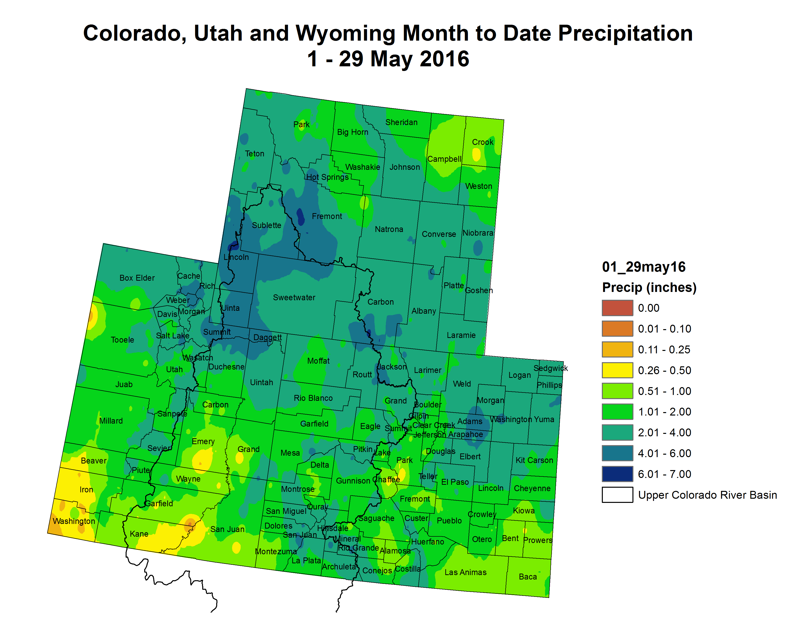
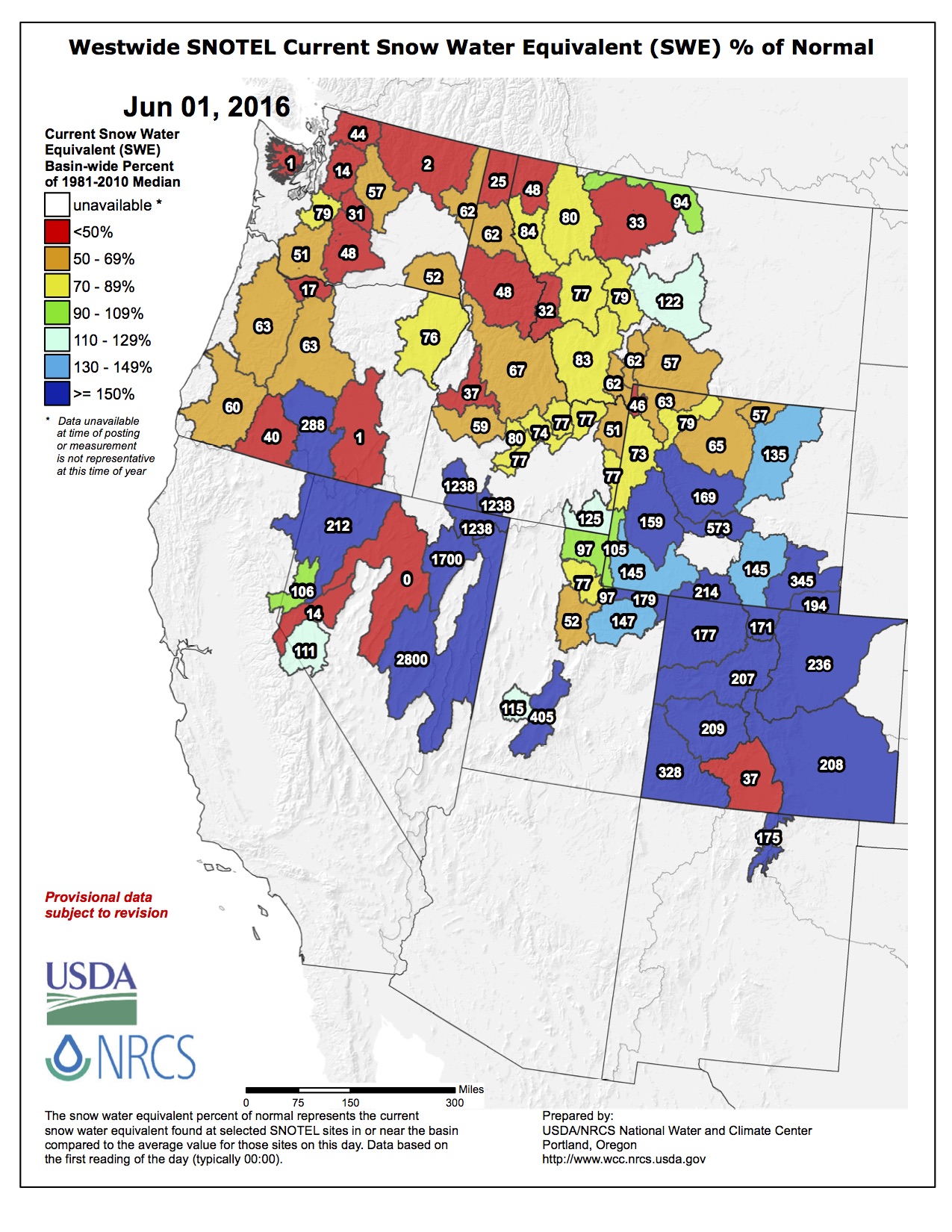
Snowpack across the Gunnison River Basin is below normal, particularly in the East River Basin where the predicted streamflow for the April through July runoff season is 78 percent of normal.
Spring runoff for the East River is likely to peak within the next few days. “The long-term average peak occurs on June 11, so this year’s peak seems to be on track or a few days earlier than normal,” Kugel said.
Reservoir conditions look to be quite different from last year. Last June, both the Taylor Park and Blue Mesa Reservoirs came within inches of spilling over. This coming summer, Taylor Park Reservoir is projected to reach somewhere between 90 percent and 95 percent of full and Blue Mesa is projected to reach 83 percent of capacity.
Kugel attributes the difference to a slightly better snowpack in the Taylor Park area and a recent 10-day peak flow release from Blue Mesa in accordance with a record of decision for the Aspinall Environmental Impact Study. Water was released for the lower Gunnison River for endangered fish habitat.
“Blue Mesa should start filling again but dropped several thousand acre-feet during the release and is currently at 69 percent of capacity,” Kugel said.
The Taylor Park Reservoir is currently at 72 percent of capacity and is in the midst of its peak release of 450 cubic feet per second (cfs), which started Tuesday, May 31 and runs through Saturday, June 4.
“We do that both to satisfy privately held instream flow rights on the Taylor River and to help flush sediments from the streambed and improve the fishery on the Taylor River. Once the release is complete, it will be stepped back down to 300 cfs over the course of a few days and it should remain at that for the month of June,” Kugel said.
That will make for good flows for several June events featuring local waterways. This year’s Gunnison River Festival, which features the annual river float and fish fry as well as events at the Whitewater Park, will take place just after the 41st annual Colorado Water Workshop.
Originally started by local historian Duane Vandenbusche and Gunnison water lawyer Richard Bratton, this year’s workshop features several authors, including Western Slope writer Craig Childs.
The Colorado Foundation for Water Education will also host a two-day tour of the Gunnison River Basin, providing an in-depth look at everything from Blue Mesa Reservoir to local irrigation practices and infrastructure to an organic farm and the Gunnison Whitewater Park.
The tour runs June 21-22; the Colorado Water Workshop runs June 22-24; and the Gunnison River Festival runs June 24-26.
FromThe Grand Junction Daily Sentinel (Dennis Webb):
The city of Rifle on Wednesday barred outdoor water use after discovering a break in the pipe delivering water from the Colorado River to its treatment plant.
Crews found the leak around 4 p.m. and the city imposed the mandatory water restriction until further notice, to maintain flows for in-house use and in the case of fire. The city said in a news release that there is no estimate of when the pipe will be repaired, but it is working diligently on the problem.
It plans to notify residents once repairs have been made via means including the city’s website, the local Channel 10 community television station and on reader boards on Railroad Avenue.
Last week, 20 or so river enthusiasts began Mountain Waters Rafting & Adventure guide training, eager to take on the six-day course that would bring them down the Animas River in a seemingly endless succession.
“We all run the same stretch of river, with the same old boats and the same old-school buses,” said Mountain Waters’ co-owner James Wilkes. “The only thing that separates one from the other is that person at the back of the boat.”
Kicking into gearThe scene at Mountain Water’s boat yard behind the Jiffy Lube on U.S. Highway 160 before classes start at 8 a.m. is a serene blend between a Dust Bowl refugee camp and a college dorm.
Campers fill the parking lot as breakfast boils over a portable stove. Trainees wedge into their wetsuits and splash gear. A lone 20-something in a bathrobe rolls a cigarette as Creedence Clearwater Revival asks in the background its eternal question: Who will stop the rain?
But once trip leader Doug Ponce calls for people to load up, the day kicks into gear.
“Being a guide really depends on your hunger and drive,” Ponce said.
Twice a year, before the rafting season gets in full swing, Mountain Waters hosts two guide training courses, which provide beginning boaters with the state-required 50 hours of experience on the river. Other companies in town offer a similar session.
And though anyone can take the course for whatever reasons, Wilkes said the training is an essential part of restaffing for the busy summer season.
“Durango people come and go,” Wilkes said. “A lot of kids do summer jobs, and then they move on. So it’s imperative we offer this training.”
Wilkes said Mountain Waters needs around 30 to 40 guides to handle the workload during peak season. Yet each year, only about 20 return, which is actually a good retention rate relative to Durango, Wilkes said.
It’s tough to gauge the town’s porous population of river guides. Wilkes estimated that with eight rafting companies around Durango, it’s likely there are about 100 full-timers, and another couple hundred on call.
A tough jobThe life of a river guide is not easy, Wilkes said. Pay can be erratic, landing trips can be competitive, and workers usually need a second job – and on top of all that, it only lasts about 10 weeks.
“It can be feast or famine,” Wilkes said.
Despite all that, there is no shortage of people who want to spend long summer days on the river.
“A lot or people see this job with a seasonal mentality, and it can be difficult,” said Ponce, who is entering his seventh year as a guide. “But if it got boring, I would have stopped by now.”
One trainee, Russ Penasa, graduated from Fort Lewis College in May, and with the flexibility of the post-graduate summer, signed up for the course hoping to land a job as a guide.
“I just figured, why not?” Penasa said. “I’ll try to get a job here, or if not, with another company in town.”
Flipping happensIndeed, the pursuit to become a guide is a labor of love. On Monday, just three days into training, Ponce gave the order to intentionally flip a raft in the precarious Corner Pocket Rapid in the Durango Whitewater Park.
“With the new whitewater park, unfortunately, flipping is something that happens,” Ponce said. “And the only way to prepare someone for that is to put them in it.”
Madison Smith, also a recent FLC grad, was one of the unlucky few jettisoned off the 16-foot raft and into the turbulent, murky waters of the Animas, running at around 3,000 cubic feet per second.
“You feel pretty vulnerable even with the life jacket,” Smith said. “But we’re learning how to have composure during chaos. People totally freak out, and it’s contagious.”
For the rest of the week, instructors, little by little, wean themselves out of the situation, allowing trainees to take over and make split-second decisions on the river.
Some will take jobs; others will take their newly acquired skills elsewhere.
Regardless, all leave with a better understanding of how to read the subtle signs in the water.
“And that’s really the most challenging part,” said Roger Dale, an instructor. “But you don’t learn how to read the river in a week or a month. It takes years.”
Lake Mead reached the new all-time low on [May 18, 2016] night, slipping below a previous record set in June 2015.
The downward march of the reservoir near Las Vegas reflects enormous strains on the over-allocated Colorado River. Its flows have decreased during 16 years of drought, and climate change is adding to the stresses on the river.
As the levels of Lake Mead continue to fall, the odds are increasing for the federal government to declare a shortage in 2018, a step that would trigger cutbacks in the amounts flowing from the reservoir to Arizona and Nevada. With that threshold looming, political pressures are building for California, Arizona and Nevada to reach an agreement to share in the cutbacks in order to avert an even more severe shortage.
“This problem is not going away and it is likely to get worse, perhaps far worse, as climate change unfolds,” said Brad Udall, a senior water and climate research scientist at Colorado State University. “Unprecedented high temperatures in the basin are causing the flow of the river to decline. The good news is that we have time and the smarts to manage this, if all the states work together.”
[…]
As of [May 19, 2016], the lake’s level stood at an elevation of about 1,074.6 feet. The federal Bureau of Reclamation, which manages the reservoir and Hoover Dam, projects the level to decline a few feet more to an elevation of about 1,071 feet by the end of June, before the level begins to rise again with releases of water from Lake Powell.
Under the federal guidelines that govern reservoir operations, the Interior Department would declare a shortage if Lake Mead’s level is projected to be below 1,075 feet as of the start of the following year. In its most recent projections, the Bureau of Reclamation calculated the odds of a shortage at 10 percent in 2017, while a higher likelihood – 59 percent – at the start of 2018.
But those estimates will likely change when the bureau releases a new study in August. Rose Davis, a public affairs officer for the Bureau of Reclamation, said if that study indicates the lake’s level is going to be below the threshold as of Dec. 31, a shortage would be declared for 2017.
That would lead to significant cutbacks for Arizona and Nevada. California, which holds the most privileged rights to water from the Colorado River, would not face reductions until the reservoir hits a lower trigger point.
Representatives of California, Arizona and Nevada said last month that they hope to have a deal finalized by the end of the year for all three states to accept cutbacks earlier than otherwise required in order to head off a more serious crisis.
Interior Secretary Sally Jewell has said she is optimistic about the talks, calling the over-allocation of the river a shared problem that must be solved. During a May 4 visit to Southern California, she said that there has been “extraordinary collaboration” between the states in working toward a deal, and that the United States and Mexico have also been making progress in negotiations on a new accord to share water from the Colorado River.
While representatives of the three states have discussed the outlines of proposals to temporarily take less water from Lake Mead, they say considerable hurdles remain, including negotiations between water districts within each state…
Scientists have estimated that rising temperatures and the resulting declines in runoff across the Colorado River Basin could reduce the river’s flow by between 5 percent and 35 percent by the middle of the century.
“Human-caused climate warming will drive larger and larger flow reductions as long as emissions of greenhouse gases continue,” said Jonathan Overpeck, co-director of the University of Arizona’s Institute of the Environment.
“The river is over-allocated even before climate change is factored in,” Overpeck said in an email. He said he thinks the negotiations will probably “focus on how to reduce the over-allocation, but will eventually have to focus on sharing the pain as climate change continues to reduce the flows.”
The long-term prognostications are just uncertain enough to be terrifying. The American Southwest—and the Los Angeles area in particular—are natural deserts. Only the miracle of engineering has made them habitable. Quite simply, we created human space in a place that, left to its own devices, would have been suitable only by cactus and lizards.
Often when we think we’ve conquered nature, we find we’ve only held it to a tenuous draw.
Bicycling the Colorado National Monument, Grand Valley in the distance via Colorado.com
FromThe Grand Junction Daily Sentinel (Gary Harmon):
Mesa County, the Grand Junction Area Chamber of Commerce and several companies will suffer no irreparable harm if a judge allows a stormwater fee to go forward, the Grand Valley Drainage District said.
If anything, the district said in court papers, it’s more likely that district residents will suffer if the fee is unnecessarily delayed.
If the district’s $3 per month stormwater charge is a valid fee, “It is not equitable to enjoin a public improvement project needed to control flooding,” the district said in its response to the plaintiffs’ request for a preliminary injunction halting the district from collecting the fee.
The district sent out bills to about 40,000 property owners this spring. The bills were due on Tuesday.
Mesa County, the chamber and several companies within the district have challenged the fee, contending that it is actually a tax that was levied unconstitutionally because it was never submitted to district residents for a vote.
The district also contends that the stormwater charge is a fee under 1983 legislation that allowed it to assess service fees for stormwater control.
The 1983 legislation also recognizes that the district can levy its own property tax.
District officials have said that the mill levy it receives is sufficient to manage irrigation runoff and seep, but that it needs additional funding to deal with stormwater.
The district plans to collect abut $2.5 million this year for improvements to facilities such as the Buthorn Drain, which directs water away from businesses and residents along much of 12th Street north of North Avenue and south of the Grand Valley Canal.
The Colorado Supreme Court already has ruled twice that charges for the maintenance, improvement and replacement of storm-drainage facilities are service fees, the district noted in its papers.
The county and other plaintiffs have challenged the fee, saying that stormwater is better handled by a valleywide drainage authority. The drainage district covers about 90 square miles while the 521 Drainage Authority encompasses about 900 square miles.
The district says in its filing that there is no need for a hearing on the preliminary injunction.
Double-digit increases in Denver’s storm drainage and sewer fees moved a step closer to reality after the proposal on Tuesday cleared its first vote 9-3 before the full Denver City Council.
But the measure, which would hike the storm drainage and sewer fees over five years, still faces pointed questions from council members before a final vote June 13. The council also has set an hour-long public hearing that night that is sure to draw pointed comments from critics who question the city’s approach, the largest project that would benefit from the fees and its link to the state’s Interstate 70 project through northeast Denver.
Under the proposal, the annual combined bills for an average single-family home would increase by $116 by 2020 to pay in part for six-year project plans and some operating costs. Storm drainage rates would increase 66 percent, while sanitary sewer rates would go up 24 percent. Otherwise, both are pegged to inflation.
“Don’t get me wrong. I’m 100 percent for a $383 million investment into our stormwater enterprise fund and our infrastructure,” Councilman Rafael Espinoza said, given the city’s extensive drainage needs.
But as he worked his way down a list of questions he still had for officials from Denver Public Works and the Urban Drainage and Flood Control District, Espinoza was among council members who focused on whether the controversial Platte to Park Hill project should take up the lion’s share.
Of the total storm drainage projects, $206 million raised through borrowing would go toward that project in northeast Denver, supplementing other sources to cover estimates that range between $267 million and $298 million.
The project, which drew the ire of attendees who wore signs on their shirts saying “NO To Storm Water Fee Increases,” is aimed at improving drainage in basins that lack natural waterways. But opponents have focused on the lack of benefit for some areas while the greatest protection would be closer to I-70, which the Colorado Department of Transportation plans to lower below grade in coming years.
Last year, the city and CDOT struck a cost-sharing agreement that includes state money for the city’s drainage projects, which would supplement the new I-70 drainage system.
Some council members said the connection troubled them. But Robin Kniech portrayed it as the city smartly responding to CDOT’s inevitable request for a contribution to the I-70 project by offering to undertake a needed project that would benefit neighborhoods as well as the highway.
“We have been chronically underfunding this infrastructure,” she said. Jolon Clark, also speaking in favor, noted that the fees proposal doesn’t specify any projects, and those planned by Public Works — including the bonds for the Platte to Park Hill project — will need future approval.
Joining them in voting yes were Kendra Black, Albus Brooks, Stacie Gilmore, Chris Herndon, Mary Beth Susman, Debbie Ortega and Wayne New — the final two characterizing their votes as tentative until after the public hearing. Espinoza, Kevin Flynn and Paul Kashmann voted no, and Paul Lopez was absent.
Storm drain and open channel improvements between the East Rail Line (38th & Blake Station) and the South Platte River (Globeville Landing Outfall), Stormwater detention/conveyance between the East Rail Line (38th & Blake Station) and Colorado Blvd, (Montclair Basin) Stormwater detention/ conveyance immediately east of Colorado Blvd. (Park Hill Basin).
Click here to read the newsletter. Here’s an excerpt:
Search for ‘hot spots’ reveals new approach to repairs
Even if there isn’t a major disruption when a water pipe breaks under the road, there will likely be hassles when it’s time to fix it.
Knowing emergency repairs can be a headache — especially when they happen in front of your home — Denver Water is always looking for ways to improve the repair process.
As part of Denver Water’s program to track and examine infrastructure conditions and needs, we recently analyzed about 630 breaks in our service area since 2013. Using locations, type of pipes, installation years and other data, we pinpointed “hot spots” with at-risk water mains.
These spots include neighborhoods on the west end of Centennial that have experienced 18 breaks in two years, over a 12-mile span. That’s more than three times the number of breaks as the rest of our service area. So we seized this opportunity to devise a new scheme. Instead of only upgrading pieces of “bad” pipe speckled throughout the water distribution system, the pipe replacement team can concentrate efforts on one area.
This spring crews began taking the new approach, which will replace about 60,000 feet of pipe throughout the targeted 12-mile zone east of South Broadway along Arapahoe Road over the next two years.
Knowing the work is cumbersome for the short term, crews are coordinating their efforts and communicating with residents before the disruptions occur.
The reward? Denver Water anticipates this new strategy will allow us to concentrate our resources on larger areas, which should reduce the odds of a main break in a community where we just worked.
The 66-mile long High Line Canal was originally built in the 1880s for irrigation purposes. It was initially 71 miles long.
Denver Water, which owns the canal, serves 30 customers. Fairmont Cemetery is the one farthest down the line.
While the canal may not carry as much water these days, the adjoining tree-lined path is often packed with people riding bikes, jogging or walking in the shade.
The High Line Canal Conservancy, a nonprofit whose mission is to protect, preserve and enhance the legacy canal, estimates that a half million people use the canal’s path system for recreational purposes every year…
But there are questions about how much longer the shade trees, many of them Cottonwoods, might last.
“They’re all over 100 years old,” said Dave Lorenz, a Conservancy board member.
Lorenz told Denver7 that there is an issue with water.
He said Denver Water routinely sent water downstream as far as the Rocky Mountain Arsenal until a few years ago.
Now water shipments are more infrequent…
He said once the trees die out, they would have to be replaced and added that young trees need frequent watering.
Lorenz said a Conservancy study group is looking at options.
“We’re working with Urban Drainage and Flood Control to see if some rain run-off could be channeled into the canal,” he said. “I’m a little concerned about that, because how many storms do we have in Colorado where we have sufficient run-off that goes in the canal?”
Lorenz said his second concern is that “Under Colorado law, the water has to be released in 72 hours.”
Lorenz said if the canal ends up dry, then they discuss whether to use the canal as a walking path, while leaving the trail for bikes.
“There may be other options,” he said.
High Line Canal
The entire 71-mile-long trail spans several jurisdictions.
Lorenz told Denver7 that he’d like to see it brought under one jurisdiction for maintenance purposes.
Some sections of the trail are paved with concrete, some with asphalt, and others, like the 19 miles in the South Suburban Recreational District, are just hard-packed gravel.
Many bike riders like it that way.
“You don’t have the high-speed road bikes,” on the gravel sections, which have to be shared with pedestrians, people walking dogs or pushing strollers,” Escalante said.
“Most of the people I’ve spoken with want it to remain gravel,” Lorenz said.
Soulsby told Denver7 she’d like to see some improvements at some busy intersections.
“It would be nice if they had more underpasses or overpasses,” she said, “so you could kind of keep going instead of getting stuck in traffic.”
She mentioned the East Yale Avenue/South Holly Street intersection which is choked with constant traffic.
Lorenz said the work group is studying several intersections and looking for possible fixes.
To learn more about the Conservancy and the upcoming planning initiative, click on this link: http://highlinecanal.org/
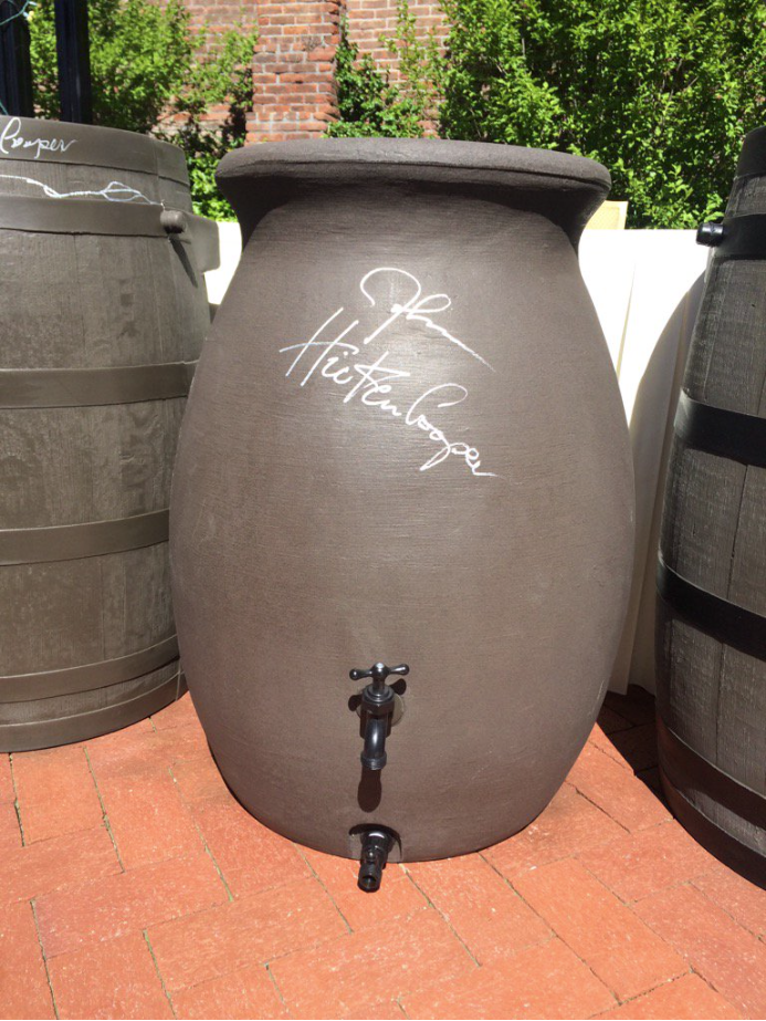
Governor Hickenlooper signed a rain barrel at the HB16-1005 bill signing ceremony. Photo via @jessica_goad and Twitter.From9News.com (Ryan Haarer):
Starting August 10, if rain falls on your roof, you can keep it. Each household can keep two rain barrels for a total of 110 gallons of water. A study at Colorado State University estimates that could add up to 1,200 gallons a year.
“At first I get worried about hail that would kill my vegetables, but then I am excited about the rain!” said Jessica Goad with Conservation Colorado…
Jessica works for Conservation Colorado which pushed hard to get this legislation passed. It failed last year because of concerns over how such a law would affect Colorado’s complicated water laws.
“The use of residential rain barrels had no impact on users downstream,” she says.
That’s according to a study by Colorado State University. The 1,200 gallons of water you could be capturing a year will not impact other areas. And the law requires further monitoring to ensure rain barrels never have an impact on other water users.
Colorado rafting companies excited about the summer season and they’re hoping for big crowds.
Nearly 100,000 people rafted just a stretch Clear Creek last year, but there are some safety precautions rafters need to take before they think about heading out.
“We expect to have a great year this year,” Clear Creek Rafting Company Manager Dale Drake told CBS4’s Matt Kroschel.
Dozens of commercial companies raft the waters in Clear Creek, and many more tackle other sections across Colorado.
The Colorado River is a lifeline in the desert, its water sustaining tens of millions of people in seven states, as well as endangered fish and wildlife. However, demand on the river’s water now exceeds its supply, leaving the river so over-tapped that it no longer flows to the sea. (Video by Pete McBride. Flights by Lighthawk, Ecoflight.)
Yo Soy Rojo El Rio Colorado | Pete McBrideYO SOY ROJO EL RIO COLORADO
Congregations from Denver to Los Angeles are screening a Spanish-language version of the award-winning film, “I Am Red” as part of their discussions about protecting God’s creation, the importance of the Colorado River and its tributaries, and the need for conservation.
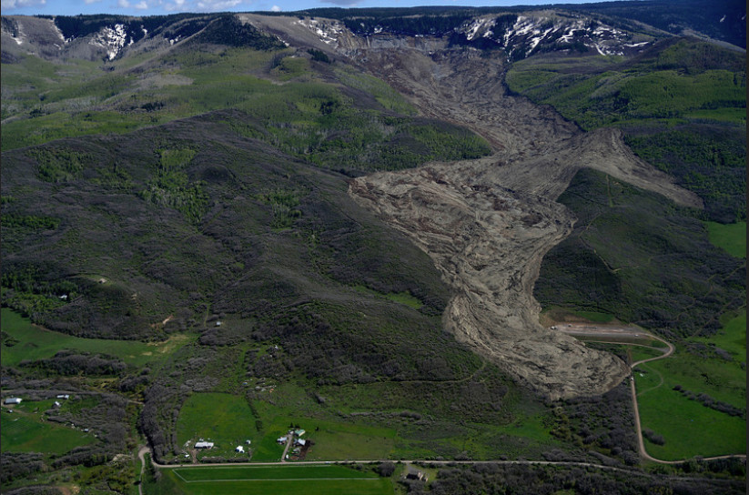
West Salt Creek landslide May 2014 via The Denver Post
FromThe Grand Junction Daily Sentinel (Gary Harmon):
Residents below the West Salt Creek landslide remained on notice Tuesday that they might have to flee on short notice should more water burst from the pond high above on Grand Mesa.
Mesa County officials on Tuesday said they were concerned that a significant amount of snowfall remains to melt and flow into the drainage, known as the “sag pond.”
The banks holding the pond left by the 2-year-old landslide ruptured last week, sending some 120 acre-feet of water rushing down the landslide, scouring Salt Creek Road as it gouged out a deep gorge through the 3-mile length of the slide.
The flood burst as the level of water in the pond topped the 20-foot level and officials said Tuesday the pond depth was at 15 feet and appearing to stabilize.
No movement of the slide mass, however, was detected.
“Right now the landslide is doing what we want and expect it to do,” the Sheriff’s Office said. “However, if Mother Nature decides to move more land down the landslide, we want residents to be ready to evacuate.”
The rush of water last week spilled onto two natural gas well pads, one of which already was shut down. The second, which was farther from the slide, was closed immediately following the slide, officials said.
Laramie Energy, which owns the wells, is prepared for the possibility that the pond might breach, said David Ludlam, executive director of the West Slope Colorado Oil and Gas Association.
Laramie contained some rust and scale inhibitor that spilled from a drum and none of the liquid left the site, Ludlam said.
State regulators were notified and no pipelines were affected.
Flood irrigation — photo via the CSU Water Center FromNPR (Liz Baker):
The City of Thornton is one of many growing suburbs of Denver, Colo. On a day without much traffic, it’s only a 20-minute commute into the state capitol, and its new homes with big yards make it an attractive bedroom community. Nearly 130,000 people live there, and the population is expected to keep booming.
All that big growth comes with a big need for water. In the 1980s, Thornton placed its hopes in the Two Forks Dam project, which would have provided the city with enough water well into the future. But when that project started to seem uncertain, Thornton started looking for another source.
“We essentially embarked on a plan to purchase a large quantity of water rights associated with irrigated agriculture in Larimer and Weld Counties,” Water Resources Manager for the City of Thornton, Emily Hunt says…
That town’s mayor, Butch White, says the town was outraged when they found out that Thornton, an urban city, was behind the purchases. Some of that anger was because of property taxes — since Thornton is a municipality, it is exempt from paying taxes on all that land surrounding the community — taxes that used to support the local school and fire districts.
There was also a deeper reason for Ault’s hard feelings: According to Colorado water law, once a water right is converted from agricultural to municipal use, that land is permanently dried out. Irrigation, and therefore agriculture, can never return to that property. And agriculture had supported the town of Ault for a century.
This process called “Buy and Dry” is the result of the West’s Gold-Rush era water laws that follow a simple rule: first in right, first in use. That means people with longer links to a property, for example, a farmer whose family has been on a piece of land since pioneer days gets water priority over someone who hasn’t been there as long…
Thornton got approval [ed. a water court decree] to divert its water shares from Ault, but that came with a lot of stipulations which make the conversion a slow process. And for its part, Thornton believes it has done a fair job of managing the situation. It pays Ault a voluntary payment in lieu of property taxes, and plants native grasses on the dried up farms…
Eventually, Thornton will build a pipeline to divert water from Ault to their city 60 miles away.