Council members and several town officials visited their Mountain Village neighbors to the north in order to discuss the proposed Telluride Regional Wastewater Treatment Master Plan. The plan has not been formally finalized, but it’s not likely to change drastically, Public Works Director Paul Ruud said.
The two-hour work session included a presentation highlighting immediate, short-term and long-term goals over the next 10 years…
The current wastewater treatment plant at Society Turn serves the communities of Telluride, Mountain Village, Eider Creek, Sunset Ridge, Aldasoro and Lawson Hill.
The plant is reaching its originally designed capacity, officials explained. Plus, Department of Public Health and Environment regulations through the Colorado Discharge Permit System have been altered over the years. (Colorado Water Quality Control Division stipulations regarding acceptable metals levels in the water also changed beginning this year.)
Those variables, in conjunction with an increased waste stream and new treatment options, make updating and eventually expanding the current plant paramount within the next decade…
Immediate focuses include talking with commercial wastewater dischargers about pre-treatment agreements, seasonal restrictions on septage hauling to the plant and a receiving station for storage of septage, among other items.
Ruud called the more immediate objectives “stepping stones.”
The long-term plan, outlined until 2027, includes plant expansion to meet possible new state nutrient regulations.
The San Miguel Valley Corporation owns the land immediately around the current plant. Ruud said there have been “very preliminary” talks with corporation officials about possibly acquiring more land.
The total cost of all proposed master plan improvements would be in the $30-$40 million range. Telluride officials explained addressing future wastewater plans in annual budgets would help with the planning process. (Telluride had a specific focus on water and wastewater projects when sculpting its 2017 budget.)
The recently opened, $22 million Fruita wastewater plant was used as an example of what is possible, but Ruud explained Telluride’s wastewater flow is higher than Fruita’s, which calls for larger improvements.
Telluride Town Manager Greg Clifton said none of the master plan objectives are necessarily “set in stone” just yet…
The city continues to replace outdated water lines, update treatment plant technology, and develop better ways to store and treat water and wastewater.
Water and wastewater projects are covered through separate enterprise funds, which use taxes and service fees to raise capital.//
For 2017, projected Telluride Water Fund revenues are $2.6 million, while projected expenditures are $3.5 million.
Plans to replace more pipes around town and the Bridal Veil Basin are in the works for this year, including repairs to pipes that carry water through the Lewis and Blue lakes areas. The Mill Creek Water Treatment Plant is in need of equipment and holding tank updates, which are projected to be $278,500, according to town officials.
Clifton added that exploring alternative, outside funding options will be a hot topic at future meetings.
On April 7, 2016, the Environmental Protection Agency proposed adding the “Bonita Peak Mining District” to the National Priorities List, making it eligible for Superfund. Forty-eight mine portals and tailings piles are “under consideration” to be included. The Gold King Mine will almost certainly be on the final list, as will the nearby American Tunnel. The Mayflower Mill #4 tailings repository, just outside Silverton, is another likely candidate, given that it appears to be leaching large quantities of metals into the Animas River. What Superfund will entail for the area beyond that, and when the actual cleanup will begin, remains unclear. Eric Baker
Erica Gaddis, the newly appointed director of the Utah Division of Water Quality, briefed a committee of lawmakers on the situation during a Tuesday hearing, detailing that 540 tons of heavy metals now rest at the bottom of Lake Powell.
Testing by the U.S. Environmental Protection Agency revealed that the heavy metal concentrations had all been flushed to Lake Powell by last July, carried along by the currents in the San Juan River.
Gaddis, who assumes her new role next Monday, said metals such as copper, zinc and aluminum tested above federal standards in 2015 in aquatic life in more than 150 samples. By 2016, only aluminum remained — with counts that exceeded the standard in 126 samples…
Gaddis told members of the Legislature’s Natural Resources, Agriculture and Environment Appropriations Subcommittee that Utah, the three other states impacted and Native American tribes are working together to monitor long-term impacts.
That task is complicated given the extent of legacy mining operations in the Bonita Peak Mining District in Colorado, where there are 48 historic mines near Silverton.
Gaddis pointed out that over the last decade, it’s estimated there have been 877 million gallons of water released, with 8.6 million tons of tailings generated from the life of those mines.
The Utah Department of Environmental Quality has been reimbursed by the EPA for nearly $464,000 in costs in the initial response and another $212,000 in costs have received preliminary approval by the federal government.
Gaddis said about $20 million has been appropriated by a congressional act to help Utah, Colorado, New Mexico, Arizona and Native American tribes with long-term monitoring.
Utah is also keeping its options open for any potential litigation against the EPA regarding the spill, she added.
Cement Creek aerial photo — Jonathan Thompson via Twitter
Colorado Water Plan website screen shot November 1, 2013
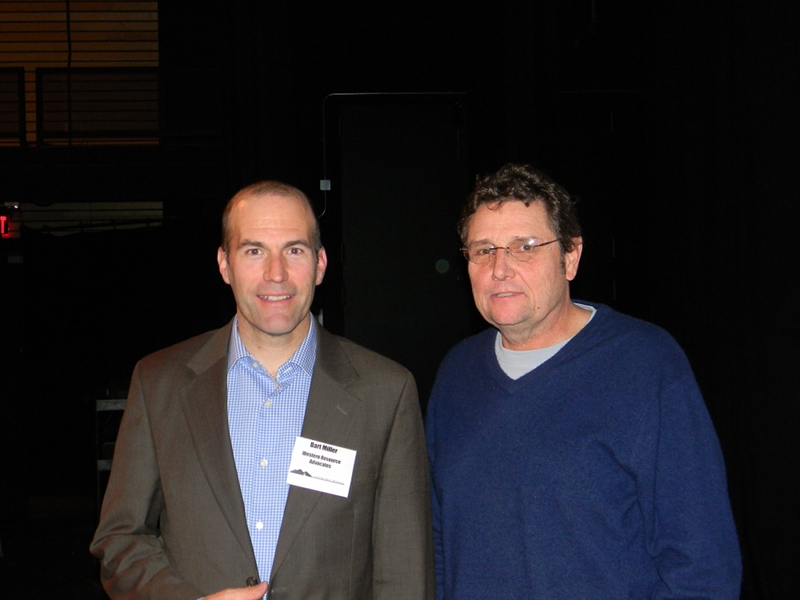
Here’s an interview with Bart Miller about the Colorado Water Plan from Water Deeply (Matt Weiser):
Recent adoption of the first Colorado Water Plan sets the state on a path to resolve projected shortfalls in water supply, but the plan has flaws that still need attention, explains Western Resource Advocate’s Bart Miller.
COLORADO FACES AN estimated water deficit of 560,000 acre-feet by 2050, due in part to an expected population increase. But it has a long-term plan to address that looming shortage.
The Colorado Water Plan – the first-ever statewide water strategy in Colorado – was ordered up by Gov. John Hickenlooper in 2013 and finalized at the end of 2015. This May, the state legislature allocated a first slug of dedicated funding to meet objectives in the plan.
The goal is to bring water demand into balance with supply while maintaining existing urban and agricultural values and also improving stream health throughout the state.
To learn more about the plan, Water Deeply recently spoke with Bart Miller, Healthy Rivers Program director at Western Resource Advocates in Boulder. Miller has followed the plan closely, both during its drafting and as implementation begins.
Water Deeply: Why this plan? What’s the conflict behind it?
Coyote Gulch and Bart Miller at the State of the Rockies Speaker Series 2011.
Bart Miller: The state of Colorado has seen and will continue to see a lot of growth – and in the last 15 years a lot of drought. So those two combined create what the plan describes as a gap in supply and demand looking out just a few decades ahead. The plan also recognizes some troubling trends in Colorado. Some of that is related to what we often refer to as “buy and dry”: cities buying up agricultural lands to get their water, and completely retiring the (farm) use on those lands.
Also, there has been some conflict between east versus west. The Front Range has harvested water from the west side of Colorado such that today there is over 500,000 acre-feet collected from the Western Front and delivered to the Front Range.
The executive order that called for the Water Plan back in 2013 was really, for the first time, describing broadly the water values the state has. Despite a history where water has been diverted for agriculture, cities and mining, the Water Plan points out there are a range of values, including viable communities, viable agriculture, viable recreation and smart land use. Those are the values the state has that cities and state agencies embrace. So I think it was an effort to get all those out on the table as co-equal partners in the state’s future water needs.
Water Deeply: Does the plan lay out a particular budget or investment scheme?
Miller: Not quite. It leaves most of the financial questions unresolved. It sets out objectives for all those different values that I mentioned. It tries to put a price tag on the funding gap to make all these things happen by 2050. The plan recognizes much of that funding will come from existing sources, in that cities, if building a water project, will be able to raise that funding and apply it to the customers they serve.
But there are some items that have been underfunded or even unfunded over the course of the past few decades. A need for new funding is things like stream health.
Water Deeply: Is there anything binding in the plan? Does it set any hard deadlines?
Miller: I’d say no. It’s largely a planning document. It suggests that different objectives could be met through a series of actions. It suggests legislation that might be helpful, as well as executive or administration actions by the state agencies in collaboration with others. It notes some things, like urban water conservation, are really going to happen through water utilities and their planning process. So the short answer is no.
But there is a pretty wide suite of recommendations, many of which are starting to be implemented. But it’s really just taking the first steps toward implementation.
Water Deeply: Is this a good plan, in your opinion?
Miller: I think yes. It’s a good planning document. It has good objectives, it recognizes a wide range of values. It doesn’t clearly spell out how we’ll get from here to 2030 or even 2050. So it’s in need of more milestones. We’ve got broad objectives for urban conservation, land-use planning, stream health and building new water storage. But it doesn’t have much in the way of measurement points, ways to check in.
And then there’s the price tag. It does spell out a need for some new sources of funding. The good news is, this year the state legislature passed a bill in May that allocates a lot of money to the state Water Conservation Board – $20 million or so – toward implementing the water plan. A project bill is passed by the legislature every year. This year is the first time they included a large boost in funding. They took an existing revolving loan account, and there’s a large enough balance in it that they felt comfortable spending part of it down, which will not be reimbursed. A lot of it will be for grants.
Water Deeply: The plan calls for 400,000 acre-feet of water savings by 2050. Is that ambitious enough?
Miller: That’s a significant number for Colorado. As a point of reference, the water project that serves the Denver metro area serves about 1.3 million customers, and their annual use is about 250,000 acre-feet. So in rough terms, 400,000 acre-feet is enough to meet the needs of over 2 million people, and probably even more. In a state like Colorado, where you’ve only got 5 million residents today, that’s a good goal and a pretty big goal, and a pretty important part of the puzzle.
Water Deeply: Even so, the plan projects a 560,000 acre-foot gap in water needs by 2050, right?
Miller: The plan did both supply and demand projections in various parts of the state. It saw there could be a shortage, yes. But interestingly, a lot of the objectives in the plan will greatly reduce that gap. For example, urban conservation. If cities continue on the track they’ve been on the last 15 years, which is reducing water use per capita by about 1 percent per year, that’s going to save a large chunk of the 400,000 acre-feet, through urban conservation. So at some level, I would de-emphasize the importance of that gap, because there are several approaches that will make that gap shrink or disappear.
Water Deeply: The plan also calls for 400,000 acre-feet of new water storage. Do we know what those projects will be?
Miller: Some of them, yes. At least a couple of those fairly large water projects are already in progress. The proponents in one case are Denver Water, and in another case a northern Colorado group of cities working together under a group called Northern Water. They both have had projects proposed for 15 years or more, and they are in the process of getting environmental reviews done.
Those two projects combined would point toward well over half of that 400,000 acre-foot goal. The rest of that 400,000 acre-foot – it’s an open question what projects will get built. And even these two are not done. They’re not built yet, and there may be delays or objections to those yet. The plan did not directly articulate which projects would be inside the 400,000 acre-foot goal.
Water Deeply: What do the watershed protection components of the plan involve?
Miller: One involves a state program – called Watershed Protection – that has been around a number of years. It does some things like sediment control and prescribed burns.
And there’s a new element tucked inside that same program that has additional funding called stream management planning. It focuses specifically on river health and streamflow. This is meant to be kind of an organic process where stakeholders inside a particular river basin identify stream reaches that are in trouble: they’re dry, or they may have temperature issues. And they try to identify what options there might be to help those streams. It’s meant to identify problems and lay out a suite of solutions.
There’s study from about five years ago that found Colorado River-based recreation and tourism generates in the neighborhood of about 80,000 jobs a year and adds about $9 billion a year to state’s economy. So there’s a growing recognition of the importance of rivers to the state.
Water Deeply: The plan also calls for identifying new funding sources for water projects. How will this work?
Miller: Yes, the plan is looking for options to raise an additional $100 million by 2020 and $3 billion by 2030. The plan estimated the unfunded piece of implementing the plan is $3 billion. All that’s still being discussed. There’s no firm plan yet for what the best mechanism for that is.
The plan recognizes there are important water values across the state that do need to be addressed to help communities meet their conservation goals. But I think the funding need is probably an underestimate, because the plan did not go into very great detail about the costs of remedying stream health.
Water Deeply: You mentioned there’s also a need to prioritize how funding is spent.
Miller: There are many objectives in the plan. And there are gaps – perceived and real funding gaps. But there’s not yet a real clear process for applying criteria on how public funds are spent.
So that’s an important next step, and I hope it will come to pass that those criteria are used. That, plus the long-term funding, will be really the proof of the truth in meeting our plan goals. The goals and objectives are great. We’ll hopefully find ourselves in a place where we’ve made good decisions two or three years from now.
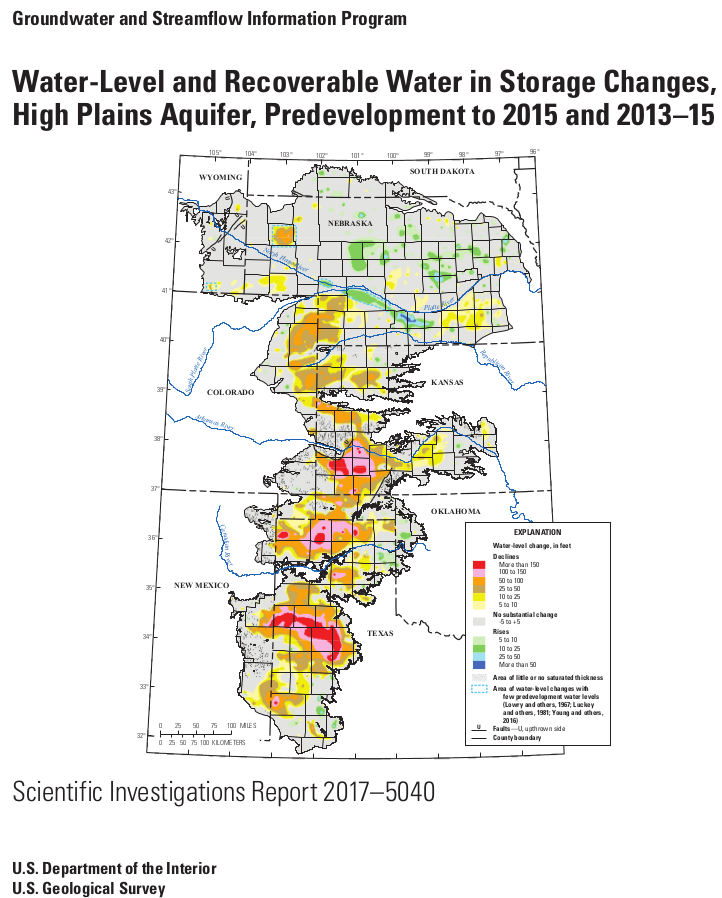
Click here to read the report. Here’s the release from the US Geological Survey:
The U.S. Geological Survey has released a new report detailing changes of groundwater levels in the High Plains aquifer. The report presents water-level change data in the aquifer for two separate periods: from 1950 – the time prior to significant groundwater irrigation development – to 2015, and from 2013 to 2015.
“Change in storage for the 2013 to 2015 comparison period was a decline of 10.7 million acre-feet, which is about 30 percent of the change in recoverable water in storage calculated for the 2011 to 2013 comparison period,” said Virginia McGuire, USGS scientist and lead author of the study. “The smaller decline for the 2013 to 2015 comparison period is likely related to reduced groundwater pumping.”
In 2015, total recoverable water in storage in the aquifer was about 2.91 billion acre-feet, which is an overall decline of about 273.2 million acre-feet, or 9 percent, since predevelopment. Average area-weighted water-level change in the aquifer was a decline of 15.8 feet from predevelopment to 2015 and a decline of 0.6 feet from 2013 to 2015.
The USGS study used water-level measurements from 3,164 wells for predevelopment to 2015 and 7,524 wells for the 2013 to 2015 study period.
The High Plains aquifer, also known as the Ogallala aquifer, underlies about 112 million acres, or 175,000 square miles, in parts of eight states, including: Colorado, Kansas, Nebraska, New Mexico, Oklahoma, South Dakota, Texas and Wyoming. The USGS, at the request of the U.S. Congress and in cooperation with numerous state, local, and federal entities, has published reports on water-level changes in the High Plains aquifer since 1988 in response to substantial water-level declines in large areas of the aquifer.
“This multi-state, groundwater-level monitoring study tracks water-level changes in wells screened in the High Plains aquifer and located in all eight states that overlie the aquifer. The study has provided data critical to evaluating different options for groundwater management,” said McGuire. “This level of coordinated groundwater-level monitoring is unique among major, multi-state regional aquifers in the country.”
From email from the Uncompahgre Watershed Partnershiip Coalition:
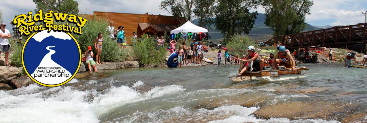
10th Annual Ridgway RiverFest 20 years in the making
In 1997, when the town of Ridway applied for its first grant to restore the Uncompahgre River in town limits, a group of visionaries imagined the area becoming a river recreation attraction for the community. Little did they know that the restored length of river and the 11-acre park on its west bank would become the site of a major watershed celebration, attracting about 500 people each year for 10-plus years.
The town is celebrating the 10th annual Ridgway RiverFest, a free community festival at Rollans Park (next to the Highway 62 bridge), on Saturday, June 24.
The first riverside celebration was organized by the town government in July 2003 when a Great Outdoors Colorado grant was awarded to the town for major river restoration. But, the official Ridgway River Festival was started by a local nonprofit, the Mosaic Community Project, in 2008. The nonprofit was formed by local mothers hoping to establish a charter elementary school in Ridgway. Though they were unsuccessful, they had lots of energy and wanted to give back to the community so they raised funds through various events and awarded grants to service projects proposed by local students.
The group funded the installation of a bench by local artist Lisa Issenberg next to the river, and a bike rack by Jeff Skoloda by the pedestrian bridge in Rollans Park. The river festival became its signature event from 2008 to 2013. In addition to a watershed education area and nonprofit booths, the festivals featured live music, food vendors, Colorado beers and margaritas, including frozen ones created by Glenda the Blenda bike. The bike had been created by the Mosaic Community Project as a way of raising funds at local events.
Since 2008 until today, the festival has also featured on-river activities and races including hard shell and inflatable boats as well as standup paddleboards. The highlight is the “Junk of the Unc” where competitors race on home-made river-crafts made of all kinds of repurposed materials.
In 2011, the Uncompahgre Watershed Partnership, a local group that aims to protect and restore local water resources through collaborative projects, joined in the festival organization. The group was created in 2007 to bring stakeholders together to monitor and improve the water quality in the Uncompahgre River and surrounding watershed, and became a nonprofit in 2013.
The partnership took over the organization of the entire festival in 2014. About half the proceeds from sponsorships, silent auction purchases and drink sales at the festival pay for the entertainment and other expenses, and the other half of the proceeds funds future water monitoring, mine remediation and other related projects.
Part-time staff and volunteer board members have kept it going by enlisting the support of dozens of volunteers and nearly a hundred sponsors each year. Ouray Mountain Rescue Team and local resident Chris Haaland have kept the river races going every year and still volunteer their time to ensure the river activities are safe and fun.
While the same popular festival activities like live music from bluesman Kipori Woods and friends are repeated each year, some special additions have been made to the 10th annual event. The silent auction area, which was initiated a few years ago, has been dubbed the River Rat Marketplace and will offer more great deals than ever on donated products, services and certificates from nearly 50 companies. A Ute flute player will join Ute elder Roland McCook to share their traditional culture. Youth areas will include a River Fairy Forest with four activity stations and a bug science demonstration. Plus, a commemorative mural will be colored by the community, and drinks will be served in reusable, collectible festival cups.
The 10th Annual Ridgway RiverFest will be Saturday, June 24, from 10 a.m. to 6 p.m. For the festival schedule and information, visit http://ridgwayriverfest.org.
Click here to go to the Conservation Colorado website to view the list:
The Colorado Legislative Conservation Scorecard highlights the priorities of the conservation community for the 2017 legislative session. Here, you will find factual, nonpartisan information on bills related to our environment and how each member of the state legislature voted on issues that affect Colorado’s air, land, water, and people.
Find out how your elected officials voted, and see how well their votes align with your conservation values. Then call or write to your legislators and let them know you’re paying attention to their environmental scores!
Exotic beetles released by the U.S. government to kill exotic trees along the upper Colorado River have munched a destructive path into central Arizona, officials have confirmed, proving to be more mobile and resilient than predicted.
The tamarisk leaf beetle now threatens the endangered southwestern willow flycatcher and other birds that have adapted to the non-native tamarisk that grows so thick along some of the region’s rivers. The beetles can strip a tree of its leaves, ruining it as a home for the birds.
Arizona environmentalists and biologists worry the beetle’s June 8 discovery in Wickenburg dooms many of the remaining flycatchers. Salt River Project has invested millions of dollars and 2,400 acres in mandated habitat protections throughout the Gila River drainage as a condition of raising Lake Roosevelt and displacing old nesting areas.
Some people, like suburban Buckeye’s mayor, are cheering the prospect of a natural thinner for the shrubby tamarisks crowding the Gila River, where thickets of the trees are blamed for flood and fire risks.
But no one knows how much farther the beetles will spread if they find new paths into the Gila River drainage area, which stretches north and east on the Verde and Salt Rivers and south on the Santa Cruz and San Pedro rivers.
An Arizona biologist found beetles and their larvae living in tamarisks on the Hassayampa River, a Gila tributary west of metro Phoenix. The insects had previously moved south from Utah’s Virgin River to Lake Mead and then down the lower Colorado. From there they moved east along the Bill Williams River and its tributaries.
Now they’re within striking distance of the heart of what remains of flycatcher country.
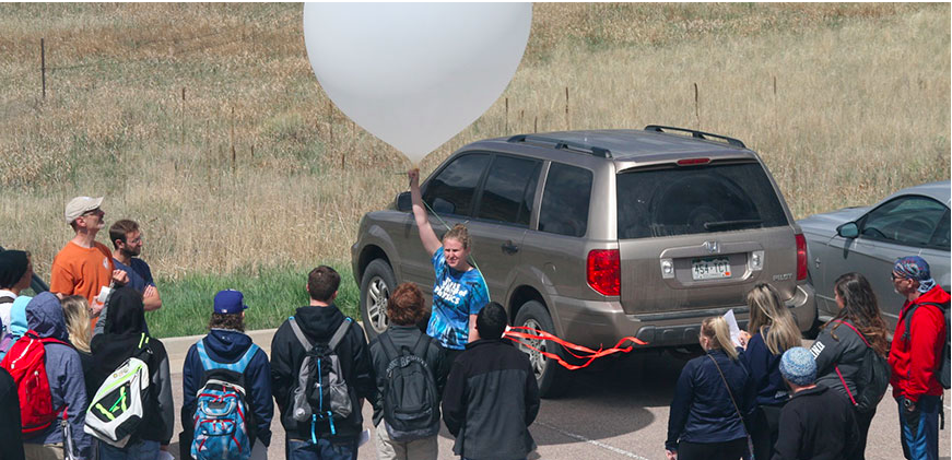
A weather balloon launch will be among the activities at the inaugural FORTCAST Weatherfest, June 24.
Here’s the release from Colorado State University (Jessica Cox):
Fort Collins Atmospheric Scientists (FORTCAST) will host the inaugural Colorado Weatherfest on Saturday, June 24, 2017, 10 a.m.-2 p.m. All events will take place at the CSU Department of Atmospheric Science, 3915 W. Laporte Avenue, on the CSU Foothills Campus.
Featuring a weather balloon launch and drone demonstration, the event – open to all ages – serves to introduce weather and climate principles through hands-on activities. Dozens of scientists from across Colorado will participate, including representatives from:
Colorado State University, Department of Atmospheric Science
The Cooperative Institute for Research in the Atmosphere
The Little Shop of Physics
Denver-Boulder National Weather Service
Colorado Climate
WeatherNation
Ball Aerospace
The Center for Severe Weather Research
The Earth System Modeling and Education Institute
University of Colorado, Department of Atmospheric and Oceanic Sciences
For any questions, contact Dakota Smith at dakota@atmos.colostate.edu.
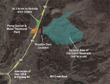
During its regular meeting on June 12, the San Juan Water Conservancy District (SJWCD) board passed a resolution to go forward with a mill levy initiative that will appear on the ballot in November.
The resolution passed 4-1, with members Rod Proffitt, John Porco, Doug Secrist and Susan Nossaman voting in favor of the motion, and member Al Pfister voting against.
Board member Ray Finney was absent from the meeting.
The mill levy would help fund the proposed Dry Gulch raw water storage project, along with a $2 million dollar loan that is contingent upon the SJWCD successfully raising its mill levy to 1 mill from .316 mills during an upcoming election.
If the mill levy initiative passes in an upcoming election, the loan would come from the Colorado Water Conservation Board (CWCB).
The $2 million would be used to pay for pre-construction costs of a reservoir, which include acquiring more land for the project…
The motion passed 4-1.
What’s in a name?
The SJWCD board also discussed changing the name of the Dry Gulch project in the hopes of differentiating the 11,000-acre-foot project from the 35,000-acre-foot project that was the subject of a legal battle.
The board discussed possible name changes, such as the High Pasture Project, or the San Juan Headwaters Project.
The board then came up with the idea of each board member rat- ing the possible choices, and then deciding on a name during the next board meeting.
Aspen stands this year had leafed out by May 5 on the north-facing slopes above Eagle-Vail, the subdivision of duplexes where I spent the 1990s. They were lovely, light and green. And seemed weeks early.
In my memory, the leaves turned out by Memorial Day, but not much before.
“You’re definitely on the money in your observation,” said Theresa Crimmins, assistant director of the National Phenology Network, when I called her about my aspen observation.
The network, founded about a decade ago in Tucson, has been documenting the impact of a generally warming climate on plant and insect life. By its estimates, spring arrived 11 days earlier in the Vail area while some parts of the nation were 30 days ahead of schedule this year.
Those estimates are based in part on the direct observations over time of thousands of people nationwide. The network has 856 registered observers in Colorado in the program called Nature’s Notebook.
Phenology is not strictly the province of professional scientists. It can be—and increasingly is—done in an organized way by people looking out their kitchen windows, noticing changes underway literally in their own backyards. People have been observing nature’s calendar—such as when lilacs bloom, hummingbirds return from the tropics, and crickets start getting noisy—for decades.
It is a discipline that depends not on memory, but upon written records, carefully and conscientiously curated.
The network also has a website here with maps created by models that draw upon data from the National Oceanic and Atmospheric Administration, among others. Two maps speak to this year’s unusual warming through April. One, the spring index map, uses a model that tracks the heat accumulated since the start of the year. The map predicts the day of the year that this index, or threshold, “that would cause plant and animals to start doing their thing,” said Crimmins.
A second map, the spring index anomaly, compares when the date for reaching any given heat threshold, or cumulative degrees-days, as compared to the average from 1981 through 2010. Meteorologists use a rolling 30-year period, updated every decade, to define what is average. Red on this map indicates early spring, and blue shows late spring.
Donald Trump would delight in how much red there was this year. On May 10, the maps showed red from the Rocky Mountains eastward, some areas as crimson as ripened cherries or dried chili peppers. Only the Pacific Northwest showed strong blue. (Portions of mountainous Colorado are green, a reflection only of insufficient data.)
“This is a general picture, and yes indeed, spring has been much warmer than usual, and it does seem that many of the plants are responding accordingly,” said Crimmins.
Does this include aspen? Not necessarily.
“If we wanted to predict when certain alpine species are changing, we should calibrate a different model with what we know about them,” she said. “A lot of it has to do with snowmelt.”
Heavy snow in Colorado this winter during December and January was followed by exceptional warmth. Temperatures in Eastern Colorado from February through April were five degrees above the 20th century average, a record. It was the second warmest three-month period in Western Colorado in records beginning in 1895. It lagged only 1934, a year of drought—and elsewhere, the Dust Bowl.
Some nights in March temperatures never fell below freezing even above 10,000 feet in elevation, says Jeff Lukas, the research integration specialist for the Western Water Assessment at the University of Colorado-Boulder. “That’s pretty unusual,” he said.
If there is always natural variability—a hot and dry 2012 followed by a coolish, wettish 2013—does this year’s weather also portend the future?
“This year is the future norm,” said Lukas.
And how much of this warming spring weather is due to atmospheric pollution, the greenhouse gases produced by modern civilization? “Some fraction,” Lukas says. That has been the overall trend over the last 30 years, he adds.
Might the Aspen Center for Environmental Studies have my answers about aspens? Jim Kravitz, the director of naturalist programs, has been tracking the aspen during the last six years. He has posted the photos of the aspen clones changing into their green garb of spring and summer and posted the comparison photos on the center’s Facebook page. The comparisons have gotten thousands and thousands of views, he reports.
This year, he reports, the aspen started leafing out four weeks earlier than compared to the last six years before May’s snow and cold put spring on pause.
Kravitz and other naturalists emphasize the value of direct observation in understanding the changing climate. “I know six years of 10 years, or even 10 years, doesn’t constitute science, but we can see things that are being projected (by climate models),” he said.
In Colorado’s alpine areas, that shift has already been documented by the Denver Botanic Gardens. Rebecca Hufft, the associate director of applied conservation, recently completed a three-year project that tapped thousands of those observations from 30-plus museums.
Filtering out observations of less than 10 years, Hufft came up with 385 species with records of seasonal changes since 1950 for alpine areas, defined here as 10,400 feet or above. That’s just a little lower than Echo Lake, near Mt. Evans. On average, these species shifted toward earlier blooming and other spring activities by an average eight days during the last 60 years.
Species did not march to an earlier climate drummer in unison, however. The study found that 45 species—including rosy pussytoes, the thickleaf ragworth, and the giant red Indian paintbush—are coming out an average of 32 days earlier.
But 340 others species—including Englemann spruce, kinnikinnick, and Colorado blue columbine— didn’t change from 1950 to 2011, the study period. No species showed a trend toward later blooming in spring.
Hufft, a plant ecologist, plans similar studies of four other ecosystem types in Colorado, such as the piñon-and-juniper and the short-grass steppes. The latter cover nearly all the eastern half of the state.
As for aspen gaining leaves, Hufft’s study did not include the species, likely because there are relatively few aspen above 10,400 feet. That doesn’t mean my memory was wrong. But neither am I sure that I’m right.
What we do have is clear evidence of warming. But if climate change is a polarizing phrase, Hufft sees plant phenology as a valuable but relatively simple tool for talking about the same thing.
“It takes the discussion away from the controversy,” she says. The evidence is there, outside local windows.
“I think when people can see that it changes, it makes a better connection to their own lives. It’s no longer abstraction, like something happening at the equator or the sea level rising. It’s concrete. There are actually things changing in their own backyards.”
As for those aspen changing in Eagle-Vail—I’d bet a beer that I’m right. But not the house.
Fog-filled Black Canyon via the National Park Service
From email from Reclamation (Erik Knight):
The spring peak operation has officially concluded. Due to an issue with the power plant at Crystal Dam, the ramp down was forced to end prematurely. As of today releases are being made through the bypass gates at a rate of 2150 cfs. This has put flows in the Gunnison River through the Black Canyon around 1150 cfs. This release rate is expected to continue for the foreseeable future. Further adjustments to this release rate may be necessary to manage the remaining runoff coming into Blue Mesa Reservoir.
The Colorado River is about 1,400 miles long and flows through seven U.S. states and into Mexico. The Upper Colorado River Basin supplies approximately 90 percent of the water for the entire basin. It originates as rain and snow in the Rocky and Wasatch mountains. Credit USGS.
Arizona has issues to work through — and a lesson to learn — before it approves a drought contingency plan for Lake Mead…
For decades, the way to decide who gets how much water from the Colorado River involved big, protracted fights in Congress and the courts.
Now, the Lower Basin states of Arizona, California and Nevada are voluntarily working on a drought contingency plan to cut the water each state gets from Lake Mead once a shortage is declared.
California would agree for the first time to take cuts, which is definitely better than the current agreement that forces Arizona to take the bulk of the cuts while California escapes with none. Arizona and Nevada also would agree to take more cuts, propping up Lake Mead levels in hopes of avoiding more drastic cuts later on.
Is it a war? A spat? A debate?
The basic framework is finished, and major players say they support the deal. Which is good news, because even if we’re expected to narrowly escape the first ever shortage declaration in 2018, things aren’t looking so good for 2019.
We don’t have a ton of time to spare to get a plan in place before cuts come home to roost.
But it’s still anyone’s guess when the agreement will be signed, because there are big tensions brewing over how those cuts will play out.
Ironically, even that tension has become a point of contention. There’s broad disagreement in Arizona over whether this is a battle, or even whether there are “sides” to this debate. The severity of the fighting depends on whom you ask.
But clearly there are strong differences of opinion over how the cuts should play out in this state, and our ability to resolve them could have wide-ranging consequences for the future.
The issue: How do we make it fair(er)?
Here’s the hangup:
Underground water banking and Pinal County farmers are first in line for cuts. Without the drought contingency plan – let’s call it DCP – there would be no excess water available for underground water banking, and farmers would lose roughly half of their allotment once Lake Mead falls to the shortage trigger level of 1,075 feet of elevation.
But water banks and Pinal County farmers would lose all of their allotment if DCP is approved. Arizona is working on a separate plan – called DCP-Plus – to spread some the cuts across higher-priority users, including tribes and cities, so the lower-priority users aren’t decimated.
That planning process ha revealed a major sticking point between the Arizona Department of Water Resources and Central Arizona Project over water levels in Lake Mead. The hydrology is complicated, and I don’t want to make your head spin.
The debate over flexibility — and cash
But in a nutshell, CAP contends that DCP-Plus could leave on the table more than 700,000 acre feet of water per year that the Lower Basin otherwise would have the rights to receive.
Instead of agreeing to conserve the same amount of water per year – which ADWR says is more prudent because lake levels can be so volatile – CAP wants the amount to be flexible to maximize the amount of water Lake Mead receives from neighboring Lake Powell.
ADWR has since scrapped an earlier version of DCP-Plus, and hydrologists from both agencies have begun meeting to revise their models. But, obviously, it’s going to take some time to get a finished plan for policymakers – who likely will slice and dice it even more.
There are other sticking points, most notably the lack of money to pay farmers for fallowing their land and not using the water they otherwise would be allotted. The state is doing its best to rustle up cash, but it doesn’t have anywhere near what it’s going to take fairly compensate everyone whose livelihood depends on the water.
Some also argue – rightly – that it’s a poor use of public cash to keep paying people year after year not to use their water. This is a Band-Aid solution, at best.
What we’re not discussing (but should)
The good news, if you want to call it that, is California is experiencing similar internal hangups over how it would shoulder DCP’s cuts. It’s not as if Arizona’s issues are holding everyone else up.
And despite the differences of opinion, it’s clear that everyone involved understands the need to work together, not let this stuff play out in Congress or the courts.
They also are keenly aware of the need to conserve water, because shortages are coming on Lake Mead. Even if we have a string of wet winters, it doesn’t change the fact that we’ve allocated more water to states than the river can produce.
They call it a structural deficit, and it’s not about to go away.
Maybe that’s the greatest lesson we should take from this process. As important as both agreements are for the state’s future, neither actually fixes the structural deficit.
That will require big-ticket projects to permanently reduce or augment our water supply, such as fixing leaky canals and expanding desalination plants.
And that means sooner or later, we’re all going to have to pony up.
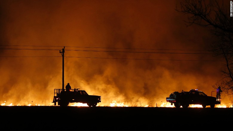
The grasslands of U.S. Great Plains have seen one of the sharpest increases in large and dangerous wildfires in the past three decades, with their numbers more than tripling between 1985 and 2014, according to new research.
The new study, published in the journal Geophysical Research Letters, found that the average number of large Great Plains wildfires each year grew from about 33 to 117 over that time period, even as the area of land burned in these wildfires increased by 400 percent.
“This is undocumented and unexpected for this region,” said Victoria Donovan, the lead author of the study and a researcher at the University of Nebraska at Lincoln. “Most studies do document these shifts in large wildfires in forested areas, and this is one of the first that documents a shift, at this scale, in an area characterized as a grassland.”
Donovan published the study with two university colleagues. The research looked at large wildfires, defined as fires around 1,000 acres or more in size.
In other parts of the globe, such as Africa’s savannas, grassland fires are extremely common — and that used to be true for the Great Plains as well. But in the past century or more, Donovan explained, wildfire suppression techniques — such as rapidly catching fires and putting them out — had largely eradicated them from the region.
However, they’ve begun to come back, a trend that has been consistent with not only climate change but also an incursion of more invasive plant species that could be providing additional fuel, Donovan said. However, the study merely documented the trend toward increased large wildfires, without formally attributing its cause.
2011 saw a particularly large surge of Great Plains wildfires, which accounted for half of the total acreage burned in the United States that year.
By specific region, some of the largest wildfire increases occurred in the Cross Timbers region of Texas and Oklahoma (which saw a 2,200 percent increase in the total area burned), the Edwards Plateau of Texas (a 3,300 percent increase), and the Central Irregular Plains, encompassing parts of Iowa and northern Missouri, as well as parts of Kansas and Oklahoma (1,400 percent increase).
Guido van der Werf, a scientist at VU Amsterdam who studies global forest fires and was not involved with the current study, said it was difficult to attribute causes behind the recent uptick in burning.
“These grassland fires are somewhat different than the forest fires we are probably more used to, and follow-up research is needed to better understand what the drivers of the upward trends were,” he said by email. “Agricultural abandonment could be one, wetter conditions later in the record another one (leading to higher and more continuous fuel beds), climate change leading to warmer temperatures, etc.”
Van der Werf said that in Africa, grassland fires have actually declined as more land has been converted to agricultural use. “Interesting to see that in other areas with other stages of development opposite trends are found,” he said.
Max Moritz, a wildfire researcher at the University of California at Berkeley, who also was not involved in the study, said the new results are consistent with other work. But he added that he suspects that they reflect not so much human-caused climate change, but rather, changing human behavior.
In particular, he cited a study from earlier this year led by Jennifer Balch of the University of Colorado at Boulder, which found that humans were overwhelmingly responsible for lighting U.S. wildfires over the past 20 years (presumably mostly by accident).
“Balch et al (2017) show the Great Plains to have increasing patterns of both lightning- and human-caused fires over this period; yet the vast majority here are caused by humans,” he said by email. “This suggests that the trends in question may largely be due to shifts in the amount, type, and timing of human activities.” For some time, wildfire researchers have worried about the growth of what they call the “wildland-urban interface,” in which more and more people are living in proximity to areas conducive to burning.
Added Moritz:
None of this should downplay the importance of dealing with anthropogenic climate change! However, it does highlight the importance of human ignitions and where/how we build our communities on the landscape. Wildfire is not going away anytime soon. We must learn, as a society, to coexist with wildfire.
Indeed, if the climate is changing in a way that increases the risk of wildfires, even as blundering humans are venturing more and more into areas where they might accidentally light them, then the two phenomena could compound each other.
Thus, it seems pretty complex to isolate the cause of the strong upsurge of plains wildfires in the United States. But whatever the cause, Donovan said, the Great Plains region isn’t used to wildfires, and that’s the real problem. Wildfire authorities tend to invest their resources out west.
Indeed, the cost of fighting wildfires in the United States has already exploded, leading to the practice of “fire borrowing,” in which the U.S. Forest Service pulls resources from other programs because it has to use them to fight fires.
“This shift could potentially strain wildfire management resources in the future,” Donovan said.
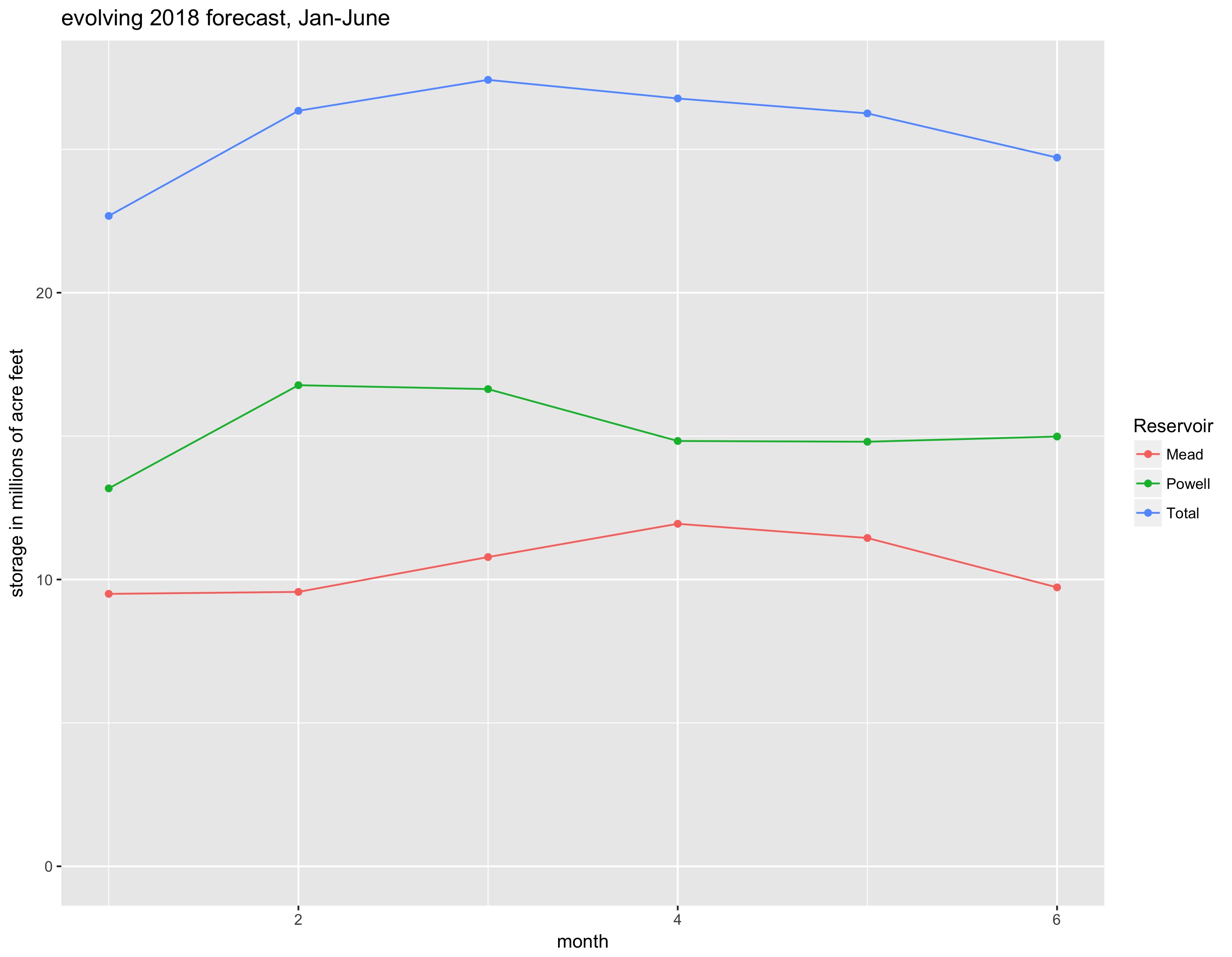
…you can see the forecast for Mead and Powell jumping up with the big snowpack, then dwindling as that potential big runoff turned into actual not-so-big-runoff. But it’s important to note that Lake Mead is still forecast to end 2018 226,000 acre feet above the projection made back in January, and Lake Powell is still projected to end 2018 up 1.8 million acre feet above the January projection. That’s a result of how the rules apportion water between Powell and Mead.
“Losses”, Daniel Kahneman and Amos Tversky wrote, “loom larger than gains.” This is one of the foundational principles of the field of behavioral economics. That’s what’s going on with the headlines. It felt like we had that water, and then we lost it.
But the final numbers are important. This year’s runoff has not been as big as we all hoped, but it was still enough to push projected reservoir levels up.
Several hundred billion gallons of water vanished from federal forecasts for Lake Mead over the past two months, but Bureau of Reclamation officials insist there’s no reason to panic.
In April, the bureau was predicting that the man-made lake east of Las Vegas would finish 2018 about 21 feet higher than it is today. Now the bureau is forecasting a 4-foot drop in the surface of the reservoir over the next 18 months — a difference of 25 feet.
But not to worry, said Rose Davis, spokeswoman for the Bureau of Reclamation in Boulder City. It’s too soon to say which scenario might turn out to be true…
The bureau released its latest forecast for the river and Lake Mead this week as part of its monthly operational study, which predicts the most likely reservoir conditions over the next two years.
The dramatic change in those projections over the past two months also illustrates how much of the reservoir’s fate is determined by policy, not Mother Nature.
The coordinated rise and fall of Lake Mead and Lake Powell upstream is governed by a complicated federal framework, implemented in 2007, that is designed to protect minimum water levels in the nation’s two largest man-made reservoirs through 2026.
In April, it looked as if the water would be high enough in Lake Powell and low enough in Lake Mead to trigger a much larger release than usual downstream to Mead in 2018. Forecasters now expect Lake Powell to fall just short of the so-called “equalization” level, resulting in a more modest water release.
Davis noted that even under the new, less promising projections, Lake Mead is still expected to be just high enough on Jan. 1, 2019, to avoid triggering the first federal shortage declaration on the Colorado River. Such a shortage would require both Arizona and Nevada to reduce their use of water from the river…
How much water is that?
Over the past two months, federal forecasters have significantly reduced their projections for the water level in Lake Mead. Instead of gaining about 21 feet between now and the end of 2018, forecasters now expect the lake to lose about 4 feet.
So how much water does that 25-foot difference represent?
Every foot in Lake Mead contains roughly 100,000 acre-feet of volume, so the recent adjustment by forecasters amounts to 2.5 million acre-feet of water. That’s equivalent to 814.6 billion gallons, which is enough water to supply the Las Vegas Valley for about a decade.
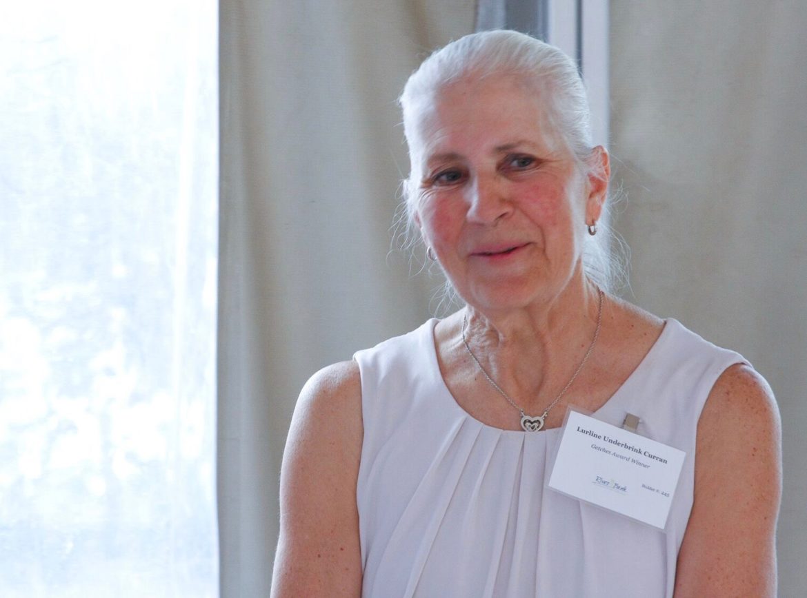
Lurline Underbrink Curran, the long-time Grand County manager, was lavished with praise Wednesday evening at the Denver Botanic Gardens, but she may have told the best joke.
Curran said she learned she was to be honored by the Colorado Water Trust after being asked to sit in on a conference telephone call with the group’s directors. The group’s mission is to restore flows in Colorado Rivers in need.
The news they purported to share seemed to comport with that mission. The new administration, they told her, had a keen interest in the Colorado River, and there were plans to remove all the dams —and make Mexico pay for it.
As she wondered what Water Trust directors were imbibing, they broke the real reason for wanting her on the phone: They wished to bestow her with the 2017 David Getches Flowing Water Award.
Getches was a law professor at the University of Colorado known to be an “inspired creator of new alternatives to old stalemates.”
Grand County long was Colorado’s best example of a stalemate. It was hit early and often for water diversions to solve Colorado’s intractable problem: about 75 percent of the state’s water originates west of the Continental Divide and almost 90 percent of people and the best agriculture lands lie to the east.
About a decade ago, at a water workshop in Gunnison, Curran described her county’s position simply: Denver, she said, had been thinking ahead—and Grand County had not.
But when two Front Range water agencies announced long-standing plans to incrementally expand diversions from the Granby-Winter Park area, Grand County chose a more sophisticated approach. It wasn’t neither hell no nor roll over.
The result is called Learning by Doing, which is premised in a cooperative effort to scientifically manage diversions in ways that cause least harm to native flows in the Fraser Rivers and its tributaries as well as the Colorado River itself.
The Windy Gap reservoir, located on the Colorado River near Granby, is part of a transmountain diversion system in Grand County. It’s been the focus of much of Underbrink Curran’s work. Photo credit Northern Water.
Sense of purpose
Eric Wilkinson, general manager of the Berthoud-based Northern Colorado Water Conservation District, which distributes water to the Boulder-Fort Collins-Greeley area through the Colorado-Big Thompson project, said he wasn’t immediately impressed with Curran when negotiations began. “I vividly remember walking out of that meeting and thinking, ‘I don’t really appreciate that woman.’”
After four years of “very extensive, intense negotiations,” he instead found Curran to be a “visionary” who was nonetheless “pragmatic but with a keen sense of purpose.”
“The Colorado River is far better now and into the future because of Lurline’s efforts and her stubborn determination to make it better,” he said.
Curran grew up in Kremmling. She had a circuitous route to public service. She managed the local bowling alley before going to work at the Grand County Courthouse in Hot Sulphur Springs, first as a secretary, then a planner before being chosen as the county manager.
Dave Taussig, a water attorney in Denver and also a director of the Colorado Water Trust, also grew up in Kremmling. His parents had a ranch at Ute Park, which is now covered by the Henderson Mill’s tailings.
“In the past, the transmountain diverters would come over and then skedaddle as quickly as they could, never to be seen or heard from again,” Taussig said.
But what Grand County did this time creates a new dynamic.
The effort is “bearing fruit already,” he said.
Editor’s note: Aspen Journalism is collaborating on coverage of rivers and water with Sky-Hi News, the Summit Daily News, the Vail Daily, the Glenwood Springs Post Independent and The Aspen Times. the Sky-Hi News published this story on June 15, 2017.
The Colorado Water Conservation Board is a known name with an often unknown role. However, one thing is certain, it is the guiding force behind water policy in the State of Colorado and has been a key provider of financial means for many important water projects in the San Luis Valley.
The Colorado Water Conservation Board was formed more than 75 years ago. The mission it was charged with was/is “To conserve, develop, protect and manage Colorado’s water for present and future generations.” Today, the CWCB is Colorado’s most comprehensive resource for water information, expertise and technical support.
The CWCB is also about those who serve. Fifteen board members govern the CWCB. Members are appointed by the governor and serve three-year terms. Each member hails from one of the nine basins of Colorado which are the Arkansas, Colorado, Gunnison, Metro, North Platte, Rio Grande, South Platte, Southwest, and Yampa/White respectively. They are responsible for tasks such as protecting Colorado’s streams and rivers, water conservation, flood mitigation, watershed protection, stream restoration, drought planning, water project financing, and the creation and oversight of the Basin Roundtables. In addition, the CWCB collaborates with other western states, as well as federal agencies, to protect state water apportionments.
Other personnel include more than 40 CWCB staff members who maintain a total of six major program areas or sections. The sections are management, finance and administration, interstate and federal, stream and lake protection, water supply planning, watershed and flood protection. These are the teams that report to the board members, make recommendations and do all of the behind the scenes work. The combined efforts of the CWCB board and staff have produced beneficial and needed results with water projects and issues throughout the state.
One example of a key initiative that was recently completed by the CWCB is the Colorado Water Plan. Until 2015, Colorado was one of the only western states that did not have a water plan. With the population of Colorado expected to see enormous increases, the demand for water is also projected to see a huge spike. There were/are also many challenges facing Colorado including an increasing water supply gap, agricultural dry-up, critical environmental concerns, variable climate conditions, inefficient regulatory process and increasing funding needs. As a result, Governor John Hickenlooper signed an Executive Order in 2013 which tasked the CWCB with the creation of a water plan for the State of Colorado.
After three years, the completion of the Colorado Water Plan was celebrated in November of 2015. Goals in the plan include meeting the water supply gap, defending Colorado’s compact entitlements, improving regulations, and exploring financial incentives. Meanwhile, the objective is to honor Colorado water values and ensure the state’s most valuable resource is protected and preserved for generations to come. The implementation of the Colorado Water Plan continues by working through individual issues in each basin. This is just one of the many complex areas the CWCB tackles on a daily basis.
With the many and often difficult issues the Colorado Water Conservation Board handles, what do these efforts mean to the Rio Grande Basin and the San Luis Valley? The answer is the Rio Grande Roundtable. The Roundtable serves two critical roles. The first is to develop a comprehensive communication platform for stakeholders, and the second is as a conduit for funding basin water projects. The Rio Grande Roundtable itself exists because of the CWCB. The concept of the Basin Roundtables was established through the “Water for the 21st Century Act” with the intent of facilitating discussion and common sense solutions for Colorado’s water needs.
Currently, the roundtables across the state bring more than 300 individuals to the table. There is an even larger amount of needs and interests represented. Each basin is also required to have a plan. These plans must identify both consumptive and non-consumptive water needs as well as available water supplies and proposed projects and methods. The projects and methods of course, require funding. This is where the CWCB Water Project Loan Program comes in. On an annual basis, the CWCB has close to $50 million available for this program. These low interest loans are available to any agricultural or municipal borrower who can establish a clear need for the design and/or construction of a raw water project. Proposed projects must then clear an application process and obtain board approval. Once each of these measures are successful, the project can begin.
The Rio Grande Basin Roundtable has been the recipient of millions of dollars in funding for crucial water projects, thanks to the Colorado Water Conservation Board. One notable example is the Rio Grande Cooperative Project. As a public/private partnership between Colorado Parks and Wildlife and the San Luis Valley Irrigation District, the Rio Grande Cooperative project was presented to the CWCB as a funding request for needed repairs to Rio Grande and Beaver Reservoirs. The request was successful and in 2013, Phase 1 of the repair process at Rio Grande Reservoir was complete. Beaver Reservoir completed its dam rehabilitation in 2016. This is just one way in which the CWCB has tremendously benefitted the San Luis Valley. In fact, it could possibly be argued that the Valley would be a much different place without the CWCB.
Colorado’s water and water in the Rio Grande Basin is and always will be an important matter. Many can agree that it must be used wisely. The Rio Grande Roundtable and the Colorado Water Conservation Board work to ensure that this valuable resource is managed well.
The Rio Grande Basin Roundtable meets the second Tuesday of every month. Meetings are located at the San Luis Valley Water Conservancy District office at 623 4th St. Alamosa. Visit http://www.rgbrt.org. or http://cwcb.state.co.us.
Lake Powell April 12, 2017. Photo credit Patti Weeks via Earth Science Picture of the day. FromThe Conversation (Brad Udall/Jonathan Overpeck):
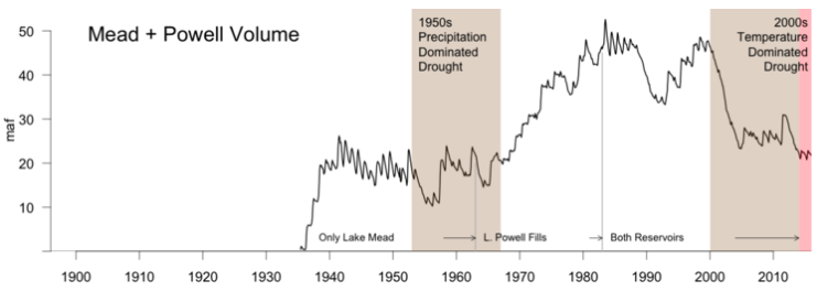
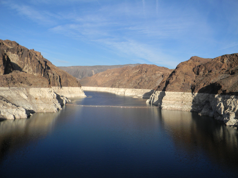
The nation’s two largest reservoirs, Lake Mead on the Arizona/Nevada border and Lake Powell on the Arizona/Utah border, were brim full in the year 2000. Four short years later, they had lost enough water to supply California its legally apportioned share of Colorado River water for more than five years. Now, 17 years later, they still have not recovered.
This ongoing, unprecedented event threatens water supplies to Los Angeles, San Diego, Phoenix, Tucson, Denver, Salt Lake City, Albuquerque and some of the most productive agricultural lands anywhere in the world. It is critical to understand what is causing it so water managers can make realistic water use and conservation plans.
While overuse has played a part, a significant portion of the reservoir decline is due to an ongoing drought, which started in 2000 and has led to substantial reductions in river flows. Most droughts are caused by a lack of precipitation. However, our published research shows that about one-third of the flow decline was likely due to higher temperatures in the Colorado River’s Upper Basin, which result from climate change.
This distinction matters because climate change is causing long-term warming that will continue for centuries. As the current “hot drought” shows, climate change-induced warming has the potential to make all droughts more serious, turning what would have been modest droughts into severe ones, and severe ones into unprecedented ones.
The Colorado River is about 1,400 miles long and flows through seven U.S. states and into Mexico. The Upper Colorado River Basin supplies approximately 90 percent of the water for the entire basin. It originates as rain and snow in the Rocky and Wasatch mountains. Credit USGS.
How climate change reduces river flow
In our study, we found the period from 2000 to 2014 is the worst 15-year drought since 1906, when official flow measurements began. During these years, annual flows in the Colorado River averaged 19 percent below the 20th-century average.
During a similar 15-year drought in the 1950s, annual flows declined by 18 percent. But during that drought, the region was drier: rainfall decreased by about 6 percent, compared to 4.5 percent between 2000 and 2014. Why, then, is the recent drought the most severe on record?
The answer is simple: higher temperatures. From 2000 to 2014, temperatures in the Upper Basin, where most of the runoff that feeds the Colorado River is produced, were 1.6 degrees Fahrenheit higher than the 20th-century average. This is why we call this event a hot drought. High temperatures continued in 2015 and 2016, as did less-than-average flows. Runoff in 2017 is expected to be above average, but this will only modestly improve reservoir volumes.
High temperatures affect river levels in many ways. Coupled with earlier snow melt, they lead to a longer growing season, which means more days of water demand from plants. Higher temperatures also increase daily plant water use and evaporation from water bodies and soils. In sum, as it warms, the atmosphere draws more water, up to 4 percent more per degree Fahrenheit from all available sources, so less water flows into the river. These findings also apply to all semi-arid rivers in the American Southwest, especially the Rio Grande.
The combined contents of the nation’s two largest reservoirs, Lake Mead and Lake Powell, since their initial fillings. The large decline since 2000 is shaded brown for 2000-2014, our 15-year study period, and pink for the continuing drought in 2015-2016. The loss was significantly influenced by record-setting temperatures, unlike a similar 15-year drought in the 1950s which was driven by a lack of precipitation. Credit Brad Udall.
A hotter, drier future
Knowing the relationship between warming and river flow, we can project how the Colorado will be affected by future climate change. Temperature projections from climate models are robust scientific findings based on well-tested physics. In the Colorado River Basin, temperatures are projected to warm by 5°F, compared to the 20th-century average, by mid-century in scenarios that assume either modest or high greenhouse gas emissions. By the end of this century, the region would be 9.5°F warmer if global greenhouse gas emissions are not reduced.
Using simple but strong relationships derived from hydrology models, which were buttressed by observations, we and our colleagues calculated how river flows are affected by higher temperatures. We found that Colorado River flows decline by about 4 percent per degree Fahrenheit increase, which is roughly the same amount as the increased atmospheric water vapor holding capacity discussed above. Thus, warming could reduce water flow in the Colorado by 20 percent or more below the 20th-century average by midcentury, and by as much as 40 percent by the end of the century. Emission reductions could ease the magnitude of warming by 2100 from 9.5°F to 6.5°F, which would reduce river flow by approximately 25 percent.
Large precipitation increases could counteract the declines that these all-but-certain future temperature increases will cause. But for that to happen, precipitation would have to increase by an average of 8 percent at midcentury and 15 percent by 2100.
The American Canal carries water from the Colorado River to farms in California’s Imperial Valley. Photo credit: Adam Dubrowa, FEMA/Wikipedia.
For several reasons, we think these large precipitation increases will not occur. The Colorado River Basin and other areas around the globe at essentially the same latitudes, such as the Mediterranean region and areas of Chile, South Africa and Australia, are especially at risk for drying because they lie immediately poleward of the planet’s major deserts. These deserts are projected to stretch polewards as the climate warms. In the Colorado River basin, dry areas to the south are expected to encroach on some of the basin’s most productive snow and runoff areas.
Moreover, climate models do not agree on whether future precipitation in the Colorado Basin will increase or decrease, let alone by how much. Rain gauge measurements indicate that there has not been any significant long-term change in precipitation in the Upper Basin of the Colorado since 1896, which makes substantial increases in the future even more doubtful.
Megadroughts, which last anywhere from 20 to 50 years or more, provide yet another reason to avoid putting too much faith in precipitation increases. We know from tree-ring studies going back to A.D. 800 that megadroughts have occurred previously in the basin.
March of 2017 was the warmest March in Colorado history, with temperatures a stunning 8.8°F above normal. Snowpack and expected runoff declined substantially in the face of this record warmth. Clearly, climate change in the Colorado River Basin is here, it is serious and it requires multiple responses.
It takes years to implement new water agreements, so states, cities and major water users should start to plan now for significant temperature-induced flow declines. With the Southwest’s ample renewable energy resources and low costs for producing solar power, we can also lead the way in reducing greenhouse gas emissions, inducing other regions to do the same. Failing to act on climate change means accepting the very high risk that the Colorado River Basin will continue to dry up into the future.
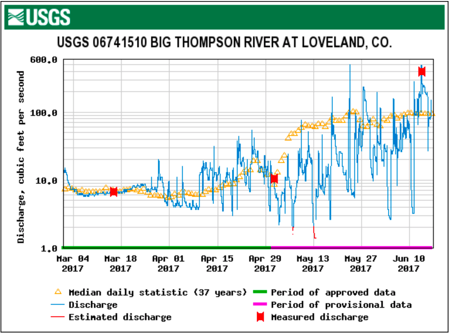
It may not look like it as the Big Thompson River and Fall River continue to race through the middle of town and a very noticeable snowpack still looms in the high country, but experts believe the peak runoff for this current season has just occurred and that we should soon see the water levels dropping.
“Right now what we can say is that it (the seasonal runoff) is comparable with previous years and we are pretty certain that it has already peaked, probably two days ago,” said James Bishop on Wednesday afternoon. Bishop is the Public Involvement Specialist for the U.S. Bureau of Reclamation in Colorado…
The flow of the Big Thompson River at Moraine Park peaked at 755 cubic feet per second (cfs) at 2:15 a.m. Sunday morning. Since then, the flow has dropped significantly to 613 cfs on Monday to 267 cfs by late Wednesday afternoon…
Checking U.S. Geological Survey Water Resources charts finds that the Big Thompson River flow just below Lake Estes peaked at 804 cfs at 3:15 a.m. Tuesday while the Big Thompson River flow at Loveland peaked at 492 cfs at 11:30 a.m. Tuesday.
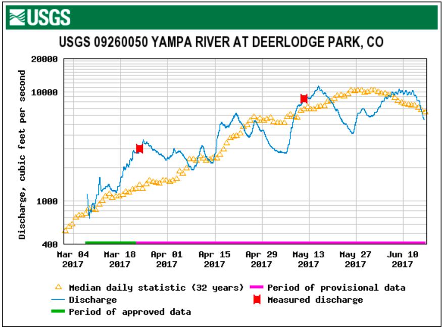
It is hot and the river looks tempting, but it is still too early to safely tube the Yampa River…
Not only is the water currently very turbulent, but it is also very cold. Steamboat Flyfisher was reporting a water temperature Wednesday of 54 degrees.
The U.S. Bureau of Reclamation’s monthly prediction for Colorado River reservoir levels says the lake could drop to 1,076.53 feet by the end of 2018 or Jan. 1, 2019. That would be a foot and a half above where a Central Arizona Project water shortage would be declared. Last month, the forecast for the end of the year was 1,096.77 feet.
A shortage declaration would cut river water deliveries to Central Arizona farmers and Arizona Water Bank recharge projects. Tucson gets most of its drinking water from CAP but wouldn’t be affected by a shortage declaration at this point — only when and if the lake drops much lower.
The forecast is down sharply from the bureau’s May 2017 prediction because this spring’s river runoff levels are less than expected a few months ago although still above normal. That means the amount of water to be released from Lake Powell downstream to Mead this year won’t be as much as was thought a few months ago. The prospect of lesser releases from Powell has been known for some time, but the 20-foot-decline in the 2019 forecast was just released.
“The severe drop-off in anticipated flows into Lake Mead represents a shocking turn-around in expectations for the near-term health of the great reservoir,” said the Arizona Department of Water Resources in an article on its website.
The abrupt forecast change underscores the need for agreement on a near-term “drought contingency plus” plan for the state to reduce the risk of shortages, Water Resources Director Tom Buschatzke said Thursday. CAP officials have opposed that plan as unneccessary in light of earlier, more favorable forecasts, leaving negotiations stuck for months. CAP officials weren’t available for comment Thursday on the latest forecast.
At the same time, Mead’s bad January 2019 forecast doesn’t mean an immediate crisis. The forecast doesn’t take into account already planned water conservation efforts by the CAP that, if carried out, will push the lake up by a few feet compared to what the bureau is forecasting, a bureau spokeswoman said.
It does, however, take into account 350,000 acre feet that California users and Arizona’s Gila River Indian Community have pledged to leave in the lake in 2017. Lesser amounts are committed for 2018 and 2019.
The Phoenix City Council added to the conservation push this week by unanimously approving a deal to pay the Gila River Indian Community $2 million to leave 40,000 additional acre feet in the lake for a year. Arizona is spending $2 million. The non-profit Walton Foundation and the Bureau of Reclamation are kicking in another $1 million apiece.
The agreement isn’t a done deal yet because CAP must approve it. But it’s already being hailed by backers as a prime example of how cooperation among users can boost the lake’s levels.
The January 2019 forecast could rise or fall later, depending on the weather over the next 18 months, reclamation officials noted.
“We offer our best projections to help our water users plan, but the hydrology is extremely variable,” bureau spokeswoman Rose Davis said Thursday.
“Pueblo County has not been notified by the Colorado Department of Public Health and Environment (CDPHE), Environmental Protection Agency or the Air Force that they have stopped monitoring, testing or sampling groundwater to track the plume,” county commissioner Terry Hart said. “If they have indeed stopped, we would most definitely be interested in learning why they stopped.
“Pueblo County is concerned about any and all groundwater contaminants. We are working aggressively to ensure that any waterway, but particularly Fountain Creek, is clean so they can be assets to our community instead of being a problem.”
State tests for PFCs in drinking water have not been done since November 2016, Colorado Department of Public Health and Environment records show. And CDPHE hasn’t measured PFCs in groundwater since February, the records show.
It’s unclear how far the PFCs contamination has moved in groundwater. Back in April 2016, groundwater samples taken south of Fountain, along Hanover Road north of Pueblo, showed PFC contamination higher than 100 parts per trillion — well above the federal EPA health advisory limit of 70 ppt.
CDPHE officials on Thursday confirmed they stopped sampling water and told The Denver Post that’s because EPA funding that enabled the tests ran out. They could not say whether the agency is still monitoring other contaminated groundwater plumes, such as those spreading PCE from dry cleaning.
“The Water Quality Control Division is not conducting any further PFC sampling. We expended the funds from the EPA to complete sampling,” CDPHE spokeswoman Jan Stapleman said.
EPA officials in Denver said state water sampling stopped but that the U.S. Air Force still is monitoring PFCs contamination as part of a military investigation at Peterson Air Force Base. That base is strongly suspected as a source of PFCs, a family of chemicals found in aqueous film-forming foams that firefighters use to douse fuel fires.
AS WESTERN STATES grapple with the best way to allocate dwindling water resources to meet multiple needs, water markets have emerged as one tool. But the idea is not without critics, such as Gary Wockner, who wrote a recent op-ed for Water Deeply about his skepticism that water markets will protect Western rivers.
Wockner raises three concerns with water markets: They commodify nature, there’s a lack of information about how much water they can really save and they skew funding to larger advocacy groups at the expense of others.
I see things differently.
Water markets don’t commodify nature. Rather, it is the prior appropriation system of “first in time, first in right” used through much of the West that gives private water users vested property rights in water. That is the root cause of this problem. It is entirely fair to criticize the prior appropriation system and if we could do it over I would advocate for a temporal permit system that protects the public interest in water from the outset and allows for periodic adjustments to these water permits as new information becomes available as to how to better protect the public interest in water resources. But that is not the world that we live in and it is unrealistic to think that will change – at least in the short term.
When it comes to information, we know enough already to show that the potential for marketing is vast. Current law – not lack of information – is the main obstacle to moving water efficiently. I have written on this topic and so perhaps have my own set of biases, but I believe that incentivizing crop switching, deficit irrigation and rotational fallowing by streamlining water transfers could yield vast quantities of water for new consumptive uses as well as non-consumptive ecological needs.
With regards to funding these projects, we should all be wary of the role that private foundations play in displacing the traditional role of government, ostensibly to promote the public good. And while we should be grateful for the positive work that private foundations have done to benefit our world, we must also acknowledge that private foundations have their own agendas, and their priorities may or may not reflect the public interest as that term might be defined by public agencies.
Nonetheless, so long as government fails or refuses to fund and address public needs adequately, foundations will have an important role to play. That does not mean that we must simply accept the choices that foundations make. On the contrary, we should demand that they be transparent and operate under standards that are fair. But we should judge the work of foundations on the merits and not be unduly suspicious of their motives. (To be clear, my work on water markets has not been funded by private foundations.)
This leads me to the broader point that Wockner raises about the need to reform our laws to protect “the rights of nature.” While I share a passion for protecting the ecological health of our water systems, I am skeptical about the prospects for an Ecuadorian-style constitutional provision.
The good news is we do not need it.
For the most part, we have the tools under our existing law that would allow us to protect the public values associated with water. We just need to use those tools in more creative and effective ways. Most prominently, in every state with positive water law (statutory and constitutional law), water is understood to be public property and, in most states, that translates into a trust responsibility on the part of the state to manage water for the benefit of the public.
Most states further demand that water resources be managed to protect the public interest. (The only state to have denied this responsibility is Colorado – the home state that Wockner and I share.)
Properly understood and properly applied, the public interest/public trust obligation offers the prospect that the communal values in water that we all share – to meet basic human needs, and to protect aesthetic, recreational and ecological needs – must be met first, before private rights are protected. Viewed in this light, and subject to these constraints, water markets are simply a mechanism for reallocating private water rights once public rights have been fully protected.
To be sure, many states have effectively ignored their obligation to manage water resources in the public interest. Other states have defined the public interest in ways that allow for balancing public values with private rights, as if they can be placed on an equal footing. This approach misconceives the nature of the public interest in water resources management. Only by first protecting those shared, communal values in water can we truly protect the public interest.
Rather than chasing a constitutional right of nature that seems unlikely to be realized, we should use the tools that we already have to rethink our approach to managing water resources. This will pose its own serious challenges; but because it is grounded in existing law, it stands a far greater chance of success. Let the hard work begin.
Click here to go to the US Drought Monitor website. Here’s an excerpt:
Summary
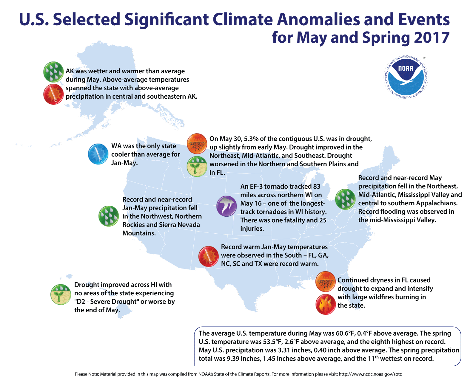
After a rather wet May with near- to slightly below normal temperatures and generally favorable growing conditions, the central Plains and Midwest have abruptly become dry and warm during the past several weeks, raising concerns of rapid top soil moisture loss and declining crop conditions. In contrast, slow-moving Pacific systems crept across the Northwest and into the northern Plains, bringing unsettled weather to the region including measurable snow to higher elevations of the Sierras while also producing scattered thunderstorms to parts of the drought-stricken Dakotas late in the period. In the Southeast, a stalled front combined with the start of Florida’s rainy season, dumped moderate to heavy rainfall (2-8 inches, locally over a foot) along the coastal areas of the eastern Gulf and southern Atlantic coasts, especially in Florida. In Hawaii, recent drier weather on windward sides of Maui and the Big Island led to D0 expansion, while wetter weather in Alaska eased wild fire conditions…
High Plains
After a dry and hot (highs in the 90s and 100s degF) early June, a system finally tracked across the northern Plains, somewhat lowering temperatures but finally bringing rain (1-3 inches) to parts of the Dakotas by the end of the week. For the most part, the rains were not great enough to make sizeable improvements to the drought, but where 1.5 or more inches fell, especially in eastern sections of the Dakotas, drought was reduced. For example, 2-4 inches of rain fell on portions of Spink, Clark, and Codington counties in South Dakota, allowing for a 1-category improvement there. D1 was also slightly trimmed in south-central South Dakota and southeastern North Dakota where bands of 1.5-2.5 inches of rain fell. D0 was removed in extreme southeastern Montana and northeastern Wyoming where short and long-term SPIs were close to normal or even wet. In contrast, downgrades were made in northeastern Montana where April-June are normally the wettest months of the year. D0 and D1 were expanded westward, and D2 was added to encompass locations such as Glasgow, Circle, Fort Peck, Jordan, Brockway, and Saco that reported their first or second driest April 1-June 12 period on record. Totals ranged from 0.8-1.31 inches, or 14-29% of normal. In the central Dakotas, lower totals (0.2-0.5 inches) plus the heat (weekly anomalies +6 to 10 degF) did little to halt deterioration as the existing D2 area expanded westward and northward in ND and southward into SD. D0 also pushed into extreme northern Nebraska and southeastern South Dakota. Even with the rainfall (and additional rains that fell after the 12Z Tuesday cutoff), it will take a while for the vegetation to respond to the moisture. Until then, cattle producers were waiting in line to reduce herd sizes, and a ND hotline for hay has been busy. Crop-wise, spring wheat conditions in the June 11 USDA/NASS report was rated poor or very poor in MT (31%), ND (17%), and SD (57%). Similarly, ND (53%), SD (45%), and MT (22%) pasture and range conditions were in similar poor to very poor shape. Elsewhere, 30-day percentages below 50% were found in eastern Kansas, hence D0 was added, based upon the criteria for short-term flash dryness as depicted in the Midwest and South…
West
June is normally dry and warm across much of the West, especially in the Southwest between the end of the wet winter season (Dec-Apr) and before the onset of the southwest monsoon season (Jul-Sep). Farther to the north, however, unsettled weather brought unseasonably wet and cool conditions to the Northwest (1.5-4 inches of precipitation to coastal Oregon, southern Cascades, south-central Idaho, and southwestern Montana), northern Great Basin, and northern California, including measurable snow to the highest elevations of the Sierra Nevada. As of June 13, nearly all of the major California reservoirs were above their historic average capacities (except Perris and Cachuma in the south coast) while Sierra statewide average snow water equivalent was at 8.4 inches, or 169% of normal. In New Mexico, scattered showers (0.5-2 inches) in south-central portions were enough to trim back some of the D0 (also in southwestern Texas) north of the El Paso area. Elsewhere, no changes were made in the West…
Looking Ahead
During the next five days (June 15-19), WPC’s 5-day QPF forecasts widespread rainfall across most of the Midwest, Southeast, central Appalachians, and Great Lakes region, with the greatest totals (2-3 inches) from northern Missouri eastward into western Pennsylvania and southward into the Carolinas. Rain should also fall on coastal Washington and the northern Rockies. Dry weather should encompass the rest of the West, High Plains, Texas, and western Gulf Coast. Temperatures should average above-normal across the southern two-thirds of the U.S., with subnormal readings limited to the northern sections of the Rockies and Plains and upper Midwest.
For the ensuing five-day period (June 20-24), odds favor sub-median precipitation in the Northwest, Rockies, northern three-quarters of the Plains, and western Corn Belt, while above-median rainfall is likely along the Atlantic and eastern Gulf Coast States, Great Lakes region, and the eastern half of Alaska. Above-normal temperatures are likely in the western half of the U.S., Florida, and the northern and southwestern coasts of Alaska, with subnormal readings in the Great Lakes region, Midwest, and southeastern Alaska.
Some slippery, spotted greenback cutthroat trout — Colorado’s long-lost and imperiled state fish — took a hit for their species Tuesday morning.
Not that the trout, lolling in a shady mountain creek southwest of Colorado Springs, had a choice.
They endured five Colorado Parks and Wildlife biologists sloshing into their already-degraded habitat to collect genetic material – eggs and milt – as part of an unprecedented ecological rescue. CPW’s Cory Noble lugged a 30-pound LR-24 Electrofisher strapped to his back, beeping like a backing-up beer truck, red light flashing, shooting electricity into the water. Cutthroats stunned by the electricity found themselves netted and then squeezed by CPW senior aquatic biologist Josh Nehring.
“It’s a female,” he said, grabbing one and massaging her pale-yellow belly with his thumb. “I got one egg out of her.”
The point?
“To improve their genetics. It is very important. This is our only known reproducing population of greenback cutthroat trout,” Nehring said, leading this mission in a three-week blitz that has collected up to 5,400 eggs in a day.
“These fish were here before man was here,” he said. “It is a unique species, a native fish. It fills a niche in the environment.”
CPW crews haul the harvested pink eggs and milky-white milt to the U.S. Fish and Wildlife Service’s National Fish Hatchery, atop the Arkansas River basin at Leadville. There, federal biologists running a captive-breeding program, using wild milt, artificially fertilized 73,000 greenback cutthroat eggs last year.
The greenback cutthroat rescue ramped up in 2012 when sleuthing by a University of Colorado team verified that the one true population of greenback cutthroat trout lives along a 3.5-mile stretch of Bear Creek southwest of Colorado Springs. While greenback cutthroats originated in the South Platte River basin, they vanished as humans settled the region. However, aspiring hotel resort operator Joseph Jones, owning property along Bear Creek in the 1870s, captured a few greenbacks and plopped them into Bear Creek hoping to draw tourists to his mountain retreat. And because of his actions, the species survived.
Greenback cutthroats were declared extinct in the 1930s, then rediscovered in 1953 and celebrated in 1994 as Colorado’s official state fish. For years, Colorado wildlife officials touting the state fish inadvertently pointed to other types of cutthroat trout. But the CU researchers determined that only the Bear Creek population carried the true genes — based on DNA analysis of cutthroats caught around Colorado compared with DNA from greenback cutthroat specimens preserved in East Coast museums. This revelation rankled some anglers who fished such Colorado high-country sweet spots as Rocky Mountain National Park and thought they caught the real thing…
CPW biologists on Tuesday said the Bear Creek habitat seems to be improving. Their latest greenback cutthroat population survey estimated 750 fish live along the 3.5-mile stretch, and they’re anticipating a new survey this fall will show a healthy increase. Greenback cutthroats are left to reproduce naturally along upper curves of the creek.
The rescue is gaining momentum. After collecting genetic material here to boost captive-breeding, CPW crews transplant thousands of greenbacks from the hatchery into native habitat in the South Platte River Basin — Zimmerman Lake west of Fort Collins, and several headwaters creeks, including Dry Gulch and Herman Gulch near the Eisenhower Tunnel, Rock Creek in South Park and Sand Creek west of Fort Collins.
Fishing for greenback cutthroats is illegal. Federal wildlife authorities have designated them officially “threatened” on the list of species protected under the Endangered Species Act, the nation’s system for preventing extinctions.
The state and federal biologists face challenges. Deformities are appearing in captive-bred greenbacks — distortions of the jaw and the gills that fish use to breathe underwater. More than 100 years of isolation in Bear Creek has rendered greenback cutthroats extra susceptible to sickness.
This compels the intense focus on improving fish genetic diversity by infusing fresh genetic material. The genetic diversity builds resilience.
“We have seen better survival in the hatchery using wild genetics,” Nehring said. “It is important to make sure that the populations we are putting out on the landscape are healthy.”
And the captive-bred greenback cutthroats released into the South Platte basin face threats from invasive nonnative fish competitors. Those creeks now are full of brook and rainbow trout introduced for sport fishing. In order to re-establish greenback cutthroats in the wild, CPW crews plan to clear creeks manually and by injecting Rotenone poison to wipe out the nonnative fish…
Eggs are fertilized along the creek, using mixing bowls and syringe-like injectors, because the eggs cannot survive longer than a day. Then crews move the fertilized eggs along with any extra milt in plastic coolers to the hatchery.
Before the biologists trudged up Bear Creek, the greenback cutthroats hung out placidly in pools, occasionally darting into faster currents to snap up flies.
CPW intern Katelyn Behounek brought up the rear gripping a large net as the collection crew worked their way up the creek, kicking through eddies and riffles, making sure zapped fish were caught.
“When you are protecting the species,” Behounek said, “it is not a disturbance.”
The city hired Ryley Carlock & Applewhite in February 2016 after the EPA and the other plaintiff, the Colorado Department of Public Health and Environment, delivered to the city a notice of intent to sue, Mayor John Suthers says in an email.
Since the suit was filed, the case has cost taxpayers $431,890 from Nov. 10, 2016, through June 2, records show. That means the city has so far shelled out a total of $724,427 to the Denver law firm for the lawsuit, which alleges the city violated the federal Clean Water Act and Colorado Water Quality Control Act by failing to meet requirements of its stormwater discharge permit, known as an MS4.
That legal bill isn’t even half of what legal bills could amount to, however.
While the original engagement capped spending with the law firm at $200,000, it’s since been amended twice. After the initial limit was exceeded by August 2016, the agreement was changed to add another $200,000. It was again amended in December 2016 after it became clear that January’s billings would top the $400,000 limit.
The new limit is $1.9 million.
But the news isn’t all bad. Ryley Carlock & Applewhite, whose attorneys command rates up to $485 per hour, are discounting their fees to the city by 15 percent, according to city records. The firm’s top three lawyers listed on the city’s agreement are James Sanderson, Britt Clayton and Richard Kaufman. Sanderson lists his areas of expertise as environmental litigation, specifically dealing with the Clean Water Act. Clayton also has experience in environmental law, while Kaufman is a litigation and public policy expert.
The lawsuit in question was actually filed seven months after Suthers and City Council approved an agreement with Pueblo County to deal with runoff. That mid-April 2016 deal requires the city to spend $460 million on storm drainage projects in the next 20 years in exchange for Pueblo County allowing the Southern Delivery System water pipeline to be activated. The city has a construction permit in Pueblo County for the pipeline containing strict guidelines for matters ranging from funding for Fountain Creek drainage projects to controlling noxious weeds.
The city flipped the switch for SDS in late April 2016.
Suthers recently told a reporter the city’s legal bills in the EPA case have averaged $100,000 a month. That’s not the case; billings so far average $45,277 a month. Asked about that, Suthers says his statement was based on the City Attorney Wynetta Massey’s estimated cost “when the case got rolling.”
Suthers says Ryley Carlock & Applewhite has handled environmental matters for the city previously.
[Northern Water] unveiled a $53 million fish and wildlife mitigation and enhancement plan for the Northern Integrated Supply Project (NISP), which proposes to funnel Poudre water into two reservoirs for 15 Northern Colorado municipalities and water districts. Among the involved communities are Windsor and the Fort Collins-Loveland Water District. The city of Fort Collins is not one of the entities that would receive water from the project.
Northern Water’s mitigation plan includes strategies to preserve some of the Poudre’s peak flows, protect wildlife habitat near the project’s larger proposed reservoir, improve the river channel and keep more water than originally planned in the river through Fort Collins.
But that’s not enough, opponents say. Project opponent Save the Poudre argues the Poudre sorely needs the high springtime flows that NISP would use to fill its reservoirs…
Northern Water project manager Jerry Gibbens, who is leading NISP mitigation efforts, highlighted four key parts of the plan for those who don’t get through all 144 pages of the document.
Keep some water in the Poudre through Fort Collins: NISP aficionados have heard of this one. Northern Water plans to run 14,000 acre feet of diverted water down a 12-mile stretch of the Poudre in Fort Collins before recapturing it for storage. The goal is to prevent dry-up spots on the Poudre in Fort Collins and preserve flows between 18 and 25 cubic feet per second.
Preserve some peak flows: Basically, Northern Water would hold off on Poudre diversions for up to three peak flow days each year, depending on whether conditions are wet, dry or about average.
During wet conditions when the reservoirs are full, Northern Water would divert no water from the Poudre during the three peak flow days. On average years, Northern Water would aim for up to three high-flow days with no diversions.
“During dry years when we’re trying to get every drop, we probably won’t have any opportunity to bypass (diversions),” Gibbens said.
Improve the river channel: The plan earmarks money for a channel and habitat improvement plan along the river. Northern Water plans to focus on 2.4 miles specifically: 1.2 miles within a reach of the Poudre from the Poudre Valley Canal to the intersection of Highway 14 and Highway 287, and 1.2 miles in the Watson Lake area north of Bellvue. Northern would fund channel reconstruction and habitat improvements. Northern also identified five sites for riparian vegetation improvement.
Conserve wildlife habitat near Glade Reservoir: Northern Water plans to put a conservation easement on land it owns around the proposed location of Glade Reservoir, the project’s larger reservoir northwest of Fort Collins. Northern plans to buy more land in the area for the same purpose. A conservation easement would protect the land from being sold for urban development, Gibbens said.
The plan also addresses water quality monitoring, water temperature mitigation, fish and bird habitat and a host of other issues. Check out northernwater.org for the full plan – but do it sooner rather than later. Colorado Parks and Wildlife is accepting public comments on the plan for 60 days, until early August.
CPW will hold an open house to talk to the public about the plan at The Ranch in Loveland at 4-7:30 p.m. June 27. Later this summer, the Colorado Parks and Wildlife Commission might suggest changes to the mitigation plan…
Gibbens said NISP won’t hamper the Poudre’s peak flows during about 82 percent of years, either because of Northern’s plans to sometimes preserve peak flows or because Northern Water’s water right is out of priority during peak flow days. Colorado water rights operate on a first-come, first-served basis, so those who own older water rights get to use the water before those who own newer water rights.
Still, NISP would result in lower average springtime flows on the Poudre, according to Northern Water’s projections. Project proponents point out it would also increase low flows during the fall and winter.
“We still will have diversions for water supply purposes, but we feel that this plan really allows those water supply withdrawals and environmental needs of the river to coexist and actually make the river a better river with the project than without it,” Gibbens said.
If approved by the U.S. Army Corps of Engineers, NISP will yield 40,000 acre-feet of water per year to participants. An acre-foot is about 326,000 gallons, enough to meet the water needs of three to four urban households for a year.
NISP participants include Windsor, Eaton, Firestone, Frederick, the Fort Collins-Loveland Water District, Fort Lupton, Fort Morgan, Severance, Lafayette, Erie, Evans, Left Hand Water District, Morgan County Quality Water District, Central Weld County Water District and Dacono.
Northern Integrated Supply Project (NISP) map July 27, 2016 via Northern Water.
Mayor Greg Stanton and the Phoenix City Council unanimously approved an agreement with tribal, state, federal and philanthropic leaders to help protect the Colorado River and preserve water levels in Lake Mead.
The agreement with State of Arizona, the Gila River Indian Community, the U.S. Bureau of Reclamation, and the Walton Family Foundation will save the equivalent of 35 percent of the Colorado River water used by Phoenix residents each year. Specifically, it will fund a contribution of 13 billion gallons of Colorado River water to system conservation in Lake Mead this year.
The Colorado River – essential to Arizona’s water supply – is over-allocated and regarded as one of the most endangered rivers in the nation, and Lake Mead is at 40 percent capacity. To preserve the state’s long-term water supply, cities like Phoenix must take a more active and leading role, said Stanton. System-wide solutions like this agreement establish a long-term partnership between tribal, federal, state and local leaders and a philanthropic foundation that helps conserve precious water resources in Lake Mead.
“Smart water policy is essential to our economy and to every Arizonan,” Mayor Greg Stanton said. “This historic agreement shows how by thinking creatively and working together we can protect our future Colorado River water supply and safeguard against the continued drought and climate change that are directly impacting Lake Mead.”
“With this action we will continue to plan responsibly for the future of our city, through partnership and collaboration,” said Councilwoman Kate Gallego. “Sustainable solutions to our water supply needs require collaboration. This agreement not only supports the overall health of the Colorado River; it also establishes a long-term partnership that helps conserve precious water resources in Lake Mead.”
“With the largest Colorado River water entitlement delivered through the CAP system, the Community has the ability to meet our needs and still make its supply available elsewhere in times of need,” said Gila River Governor Stephen R. Lewis. “We consider this agreement a continuation of our commitments made to the United States in January that will allow Arizona parties to continue their negotiations and efforts to adopt a comprehensive plan that meets Arizona’s water supply needs and also addresses the severe drought on the Colorado River.”
“This agreement will allow for the creation of tools that will be effective in protecting Lake Mead,” said Thomas Buschatzke, Director of the Arizona Department of Water Resources. “Those tools will be enduring and inclusive, allowing for participation by a broad group of Arizona water entitlement holders and other constituencies.”
Under the agreement, the Gila River Indian Community will contribute 40,000 acre-feet of its Colorado River allocation to system conservation. The City will contribute $2 million towards the program. While the financial commitment in this agreement is for one year only, it is anticipated that the State of Arizona, the City of Phoenix, the Walton Family Foundation, and others may continue those contributions into the future to develop a regional system conservation program that will be open to additional water contributors and additional funders.
“Phoenix continues to plan for conditions on the Colorado River to ensure it is well positioned to contend with shortages,” said Councilwoman Thelda Williams who chairs the Arizona Municipal Water Users Association. “We must protect and preserve the rivers and lakes that our city and state rely upon; this agreement is a prime example of working together with regional partners to create a smart approach for system conservation of the Colorado River and Lake Mead.”
“Economic development in the state of Arizona depends on a secure water supply,” said Councilman Jim Waring. “This agreement helps create resiliency on the Colorado River, economic security, and most importantly, certainty for the future of Phoenix.”
“The combined metropolitan areas in Arizona, Southern California, Colorado and Nevada served by the Colorado River represent the world’s 12th largest economy, and no matter how well Phoenix has planned to avoid a water shortage, the regional economy may suffer if reliable water supplies are threatened,” said Councilman Daniel Valenzuela. “This agreement shows the City of Phoenix is taking proactive steps to be sure we have enough water under any future circumstances.”
“Phoenix is a leader when it comes to smart, water supply planning, which is vital for our city’s future,” said Councilwoman Debra Stark. “As someone with a planning background, I know the importance of coming up with creative solutions for real issues. This agreement is a great partnership that has led to an innovative water conservation system.”
“I am proud that the City Council unanimously approved this agreement to help preserve the state’s long-term water supply through system conservation on the Colorado River and in Lake Mead,” said Councilman Michael Nowakowski. “With this vote, the City of Phoenix has a taken the lead in ensuring future generations will have a resilient water supply and a catalyst for economic prosperity.”
“I was part of the original water settlements for the City,” said Councilman Sal DiCiccio, “And it’s critical we continue to move forward with our conservation efforts. I am proud to support this innovative agreement that helps protect Phoenix’s precious Colorado River water supply.”
Funding for Phoenix’s portion will come from the Colorado River Resiliency Fund, which was approved by the Phoenix City Council in 2014. The Colorado River Resiliency Fund supports projects focused on water supply resiliency, including system conservation efforts.
“I particularly want to recognize the visionary leadership of Governor Stephen Roe Lewis and the Gila River Indian Community as we move forward with this partnership,” added Gallego. “The Gila River Indian Community has been an excellent partner for the City of Phoenix in this process, and I look forward to both our communities working together in the future. As a desert city, Phoenix knows the value of water and its importance for our future, and I’m extremely proud to take part in this innovative water resource partnership.”
To stem falling water levels and help prevent a shortage, the Gila River Indian Community will leave 40,000 acre-feet of its river allocation in Lake Mead. In exchange, the city of Phoenix, state of Arizona and Bureau of Reclamation will each pay the tribe $2 million. The Walton Family Foundation will contribute $1 million.
The tribe’s water contribution is equivalent to 13 billion gallons of water, which equals 35 percent of Phoenix’s annual consumer use.
City and Gila River officials say it is the first agreement of its kind, with local, federal and tribal governments joining to conserve the region’s water. Cities have leased tribal water in the past but, under this deal, the water will not be used.
For years, the Colorado River system has been drained faster than it has been refilled. Water levels have dropped about 12 feet a year in Lake Mead, which today sits at 1,081 feet above sea level.
If that level falls below 1,075 feet, the secretary of the Interior will declare a shortage. Larger shortages would be triggered at 1,050 feet and 1,025 feet, severely reducing the city’s water access.
“It is unchartered territory,” Phoenix Water Services Director Kathryn Sorensen told the council. “Our economies can withstand controlled shortages of known quantities. We can plan for that, but it is difficult to plan for the unknown.”
Leaving water stored in Lake Mead will slow the decline in water levels and give water managers in the seven Colorado River states more time to work on long-term conservation plans.
It is the second water agreement between Phoenix and the Gila River community this year. In March, the city agreed to store 3,800 acre-feet of its water in aquifers along the Gila, restoring flow to the tribe’s namesake river. That deal allowed the city to set aside some of its Colorado River water in case of a future shortage. The city also paid the tribe a storage fee.
Already, that water has brought life back to the long-brown banks of the Gila. Birds and coyotes have returned, and plants have grown so quickly the tribe is now looking for volunteers to cut back the greenery.
Gila River Indian Community Governor Stephen Roe Lewis and Stanton are longtime friends from before their time in office.
“As neighbors, we can accomplish great things together,” Lewis said. “And historic agreements like this one make it easier to work on other matters that may impact our communities from time to time.”
The one-year agreement will be formally signed next month at the Gila River Indian Community, with hope that a long-term Arizona drought contingency plan will be in place by the end of the year.
Colorado River Basin including out of basin demands — Graphic/USBR
Rivers are raging in Colorado now due to snow melt and a wet spring…
Deputies and first responders have been forced to make several water rescues already this year, leading to rafting restrictions across Jefferson County that will last until water levels decrease.
Authorities in Larimer County also expect the high water levels to persist as temperatures continue to rise. They anticipate tens of thousands of people to visit county waterways through the summer alone.
Follow these tips to stay safe while out on the waterways:
·Tell someone where you are going, when you expect to return and where and who to call if you don’t. If your plans change while you are traveling, put a note in your car on the driver’s side dashboard with the new plans.
·Wear a life jacket. Wear a properly fitting personal floatation device for all river activities. Don’t assume you have the swimming skills to keep afloat, even the strongest swimmers can drown.
·Keep a close watch on children, even if they are far from the water. Water safety for children is especially important as they can quickly enter the water and get in trouble when your attention is diverted for only a moment.
·Never walk, play or climb on slippery rocks and logs near rivers and streams.
·Stay away from riverbanks during times of high flowing water. The banks may have become unstable and give way underneath you.
Jefferson County Sheriff Jeff Shrader and the Golden Police Department will limit access to Clear Creek both within Golden, including at Vanover Park, and in unincorporated Jefferson County.
The order prohibits water activities including belly boats, inner tubes and single chambered rafts, as well as “body-surfers” and swimming.
People who use kayaks, paddle boards, whitewater canoes and multi-chambered professionally guided rafts and river boards can still access the river, but law enforcement officials urge people to use extreme caution due to safety concerns about swift moving water and floating debris. Anyone who gets on the river must use a Coast Guard-approved paddling life jacket and wear a water-use designed helmet…
Water across the state is running high and fast, but that’s normal for this time of year, when snowmelt and rain make the rivers swell, National Weather Service hydrologist Tony Anderson said.
The water in your tap — the stuff you pay pennies per gallon for — just earned recognition as the best tasting water in the United States.
This week, the American Water Works Association rated Greeley’s water the best tasting in the nation, as Greeley beat out 33 other regional winners. The city also became the first to win the national competition and People’s Choice Award at the organization’s annual conference in the 13-year history of the competition.
Greeley also is the first Colorado municipality to win the award.
And then there’s this: This was the first year Greeley has entered the contest.
“I was hopeful,” Greeley Water and Sewer Director Burt Knight said. “But I never expected to win both awards.”
Still, Knight said the awards didn’t tell him anything he didn’t already know.
“What it does is it confirms the choice our forefathers made when they went up to the mouth of the Poudre and built the treatment plant and pipeline in 1907,” Knight said. “I know we have high-quality water. All we needed to do is get everybody else to agree.”
Now that they have, Knight and others are pondering how, exactly, they’ll spike the football.
“It’s something we’ll need to think about leveraging,” City Manager Roy Otto said, adding the city has used its extensive water portfolio to attract businesses in the past. “But quality is something we need to spend time communicating to people — not only to residents, but others who might be coming to Greeley, as well.”
There are strict rules for the water competition. Greeley was sent special containers and coolers. Officials took water from one of the treatment plants and shipped it off to Philadelphia, where the annual convention was held.
Once there, contest officials remove any labels to ensure a blind taste test for judges.
To get there, Greeley had to win its regional competition last fall. And as a result of its national win this year, Greeley gets an automatic bid to the national competition next year.
Will the city enter?
“If you’re the Broncos, and you win the Super Bowl, you want to defend your title,” Knight said.
But that’s for next year. For now, Greeley officials are happy celebrating the victory.
Otto said he’s proud of the tradition and legacy of water in Greeley, saying the award is an affirmation of that.
W.D. Farr
“W.D. Farr has a big smile on his face in heaven right now,” Otto said, referencing the Greeley water pioneer.
After Farr died, Greeley bottled some of the town’s water, labeling it “Greeley Gold.” Otto still has a bottle.
“I would put Greeley’s water supply up against any bottled water across the country,” Otto said.
Greeley, a city known for both agriculture and food processing businesses, can now boast it has the best tasting tap water in the United States and Canada.
The Greeley Water and Sewer Department won the 13th annual “Best of the Best” Tap Water Taste Test conducted by the American Water Works Association. Montpelier, Ohio, took second place and Bloomington, Minn., had the third-best tasting tap water.
Greeley represented the Rocky Mountain Section of the American Water Works Association in the contest held in Philadelphia, Pa. The Rocky Mountain group includes water companies from cities in Colorado, Wyoming and New Mexico, said Greg Baker, spokesman for the organization. It is the first time that any member of the Rocky Mountain association has won the contest, Baker said.
The event, composed of regional winners from water-tasting competitions across North America, was held at American Water Works Association’s Annual Conference and Exposition in Philadelphia, Pennsylvania. Fifteen regions participated in the contest, including some in Canada and Puerto Rico.
Here’s the release from the University of Northern Colorado:
The Howard Hughes Medical Institute awarded the University of Northern Colorado a five-year, $1 million grant to develop a classroom model and establish a new center to engage more students, from all backgrounds, in the sciences.
UNC is one of 24 colleges and universities selected out of 511 that submitted pre-proposals in the first round of the Inclusive Excellence initiative sponsored by HHMI, the largest private, nonprofit supporter of science education in the United States.
As part of the award, UNC faculty will research student experiences in their STEM classrooms to better understand the conditions that support intrinsic motivation among students. Faculty will then analyze the data and implement instructional practices to help achieve student success —in particular among STEM majors from underrepresented racial and ethnic groups, families in which the student is the first to attend college, low socioeconomic backgrounds in addition to students who transfer, or are military veterans or who identify as LGBTQ.
One of the project’s goals is to increase retention and graduation rates of these traditionally underserved students. The grant will also establish the new Center of Inclusive Excellence in STEM, which will provide infrastructure and leadership to continue STEM faculty development and expand this professional development across campus.
“Our goal is for this work to lead to a culture at UNC where STEM inclusive excellence is the norm and where conversations about improving conditions for intrinsic student motivation and success are commonplace.” said the grant’s principal investigator Susan Keenan, professor and director of the School of Biological Sciences.
HHMI expects that the Inclusive Excellence grants will produce useful models for other schools that might share similar contexts and challenges.
Project Title: Improving Classroom Culture to Support Intrinsic Motivation as a Pathway to STEM Inclusive Excellence
Grant award: $1 million, September 2017-August 2022
Funding Agency: Howard Hughes Medical Institute
Researchers: Project Director Susan Keenan (professor and director of Biological Sciences), Co-Project Directors, Lori Reinsvold (acting director of UNC’s Mathematics and Science Teaching Institute) and Jodie Novak (professor of Mathematics), and Investigator Cassendra Bergstrom (assistant professor of Psychological Sciences)
Of note: Over multiple stages of peer-review by scientists and science educators, HHMI identified 24 schools out of 511 that applied for Inclusive Excellence 2017 awards.
Here’s the release from NOAA (John Leslie and Brady Phillips):
The month of May typically signals both an ending and a beginning: The waning days of spring and then the time-honored leap into summer vacation season.
Before we throw on our bathing suits and flip flops, let’s first take a look back at how last month, spring and the year to date fared in terms of the climate record:
Climate by the numbers May
Last month, the average contiguous U.S. temperature was 60.6 degrees F — 0.4 degrees above the 20th-century average — ranking near the middle of the 123-year period of record. Parts of the West and Southeast were warmer than average with near- to below-average temperatures in parts of the Central and Eastern U.S., according to scientists from NOAA’s National Centers for Environmental Information.
The average precipitation total for May was 3.31 inches, 0.40 inch above the 20th-century average and tying with 2009 as the 25th wettest on record. Above-average precipitation fell across most of the East and parts of the Rockies and Great Plains.
Spring
The average spring (March-May 2017) temperature across the contiguous U.S. was 53.5 degrees F, 2.6 degrees above average, making it the 8th warmest spring on record. From the Rockies to East Coast, most of the seasonal warmth occurred during the early and middle parts of spring.
The average spring precipitation total was 9.39 inches, 1.45 inches above average, making this spring the 11th wettest on record.
Year to date
The year to date (January through May 2017) average temperature for the contiguous U.S. was 47.0 degrees F, 3.7 degrees above the 20th-century average. This YTD period was the second-warmest on record for this period.
The YTD precipitation total was 14.85 inches, 2.46 inches above average, making it the third-wettest January-May on record.
A map of significant climate events that occurred in the U.S. during May and Spring 2017. (NOAA)
Other notable climate events and facts included:
Record rains in the U.S. East, South: Record and near-record May precipitation fell in the Northeast, Mid-Atlantic, Mississippi Valley and central to southern Appalachians. Record flooding was observed in the mid-Mississippi Valley.
Florida remains tinder dry: Continued dryness in Florida caused drought to expand and intensify, prompting large wildfires across central and northern areas of the Sunshine State.
A record-breaking Wisconsin tornado: An EF-3 tornado tracked 83 miles across northern Wisconsin on May 16 resulting in one fatality and 25 injuries. This was one of the longest-track tornadoes in the state’s history.
Continued drought relief: On May 30, 5.3 percent of the contiguous U.S. was in drought, up slightly from early May. Drought improved in the Northeast, Mid-Atlantic and Southeast. Drought worsened in the Northern and Southern Plains and in Florida.
Washington State had a cool start to year: Washington was the only state cooler than average for January to May.
Coastal flooding events rose markedly last year: An update to NOAA’s annual report of high-tide flooding (sometimes referred to as nuisance flooding) found that among most of the cities studied, flooding increased in 2016 by 130 percent on average since the mid-1990s and continues to accelerate.
The city of Aspen has rejected an initial settlement offer made in the unfolding water court cases about conditional water rights tied to two large potential dams on Castle and Maroon creeks.
On May 23 the city’s water attorney, Cynthia Covell, sent a letter to the water attorney for the Larsen Family Limited Partnership, rejecting its settlement proposals made on May 8 and 11.
“Aspen cannot accept your client’s settlement offer,” Covell told Larsen Family attorney, Craig Corona.
The Larsen’s proposal required the city to stay, or put on hold, it’s two current applications to the court to extend its conditional storage rights for another six years.
Then the city could file a new request with the water court to change those conditional water rights to another location and size outside of the Castle and Maroon creek valleys and somewhere within the city limits.
“Our offer was quite clear that there were terms that could be negotiated, and the basic concept was that we would support (along with the other opposers) Aspen’s relocation of its dam rights, in a location and amount to be determined through negotiation,” Marcella Larsen of Larsen Family LP said.
In his May 11 letter, attorney Corona told the city, “If there’s no objection and the change is decreed, dams won’t be built in the wilderness and the city will retain its water rights – a win-win.”
But establishing new water storage rights within city limits, with a 1971 priority date, without opposition, may be hard to do, even with the opposing parties in the current cases sitting on the sidelines.
The current water court review was triggered when the Aspen filed two applications in October to maintain its conditional water storage rights, which were decreed in 1971.
Larsen Family LP is one of ten opposing parties in the resulting “due diligence” cases now before the Division 5 water court referee in Glenwood Springs.
The other parties include the U.S. Forest Service, Pitkin County, four environmental organizations, and three owners of high-end residential property in the Castle and Maroon creek valleys.
Corona told the city there was a “general consensus” among the other parties in the case in support of the Larsen Family proposal, which technically only pertained to the Maroon Creek Reservoir case.
But the city decided to sit on its cards.
On May 22, the council held an executive session to discuss, in part, the water court cases.
On May 23, Covell sent Corona the city’s rejection letter.
Corona then sent the letter to the other opposing parties.
“A new application to change the location (of) the Maroon Creek Reservoir conditional storage right would require that a new location be specified,” the city’s May 23 letter said, according to an attorney in the case. “Aspen must complete its supply/demand study and identify an alternative location or locations for the Maroon Creek Reservoir storage right in order to be able to file a change application to move that right, or some portion thereof, to another location.”
Asked about the rejection of the settlement offer, Aspen City Manager Steve Barwick would only say last week via email that ”the City of Aspen is still working with all parties in the water case with the hope of reaching a mutually agreeable settlement. We are still trying to refine water supply and demand estimates and study alternative storage locations.”
A second closed-door and facilitated settlement meeting hosted by the city for the opposing parties is being set up for the first week of August. The first such meeting was held in March.
A map showing the location of the potential Maroon Creek Reservoir.
1965 filing
The city’s conditional storage rights on Castle and Maroon creeks date back to 1965, when the first told the water court it intended to build two reservoirs to meet forecasted demands.
In October 2016, the city again told the state it still intends to build the reservoirs, someday, if necessary.
But since October the city has also has been openly studying alternatives to the two reservoirs, and doing so with the knowledge that it’s possible, in some water court cases, to move and adjust conditional storage rights.
As currently decreed the Maroon Creek Reservoir would hold 4,567 acre-feet of water behind a 155-foot-tall dam just below the confluence of East and West Maroon creeks, within view of the Maroon Bells.
And the Castle Creek Reservoir would hold 9,062 acre-feet of water behind a 170-foot-tall dam across Castle Creek two miles below Ashcroft.
Both dams would flood some portion of the Maroon Bells –Snowmass Wilderness.
The city has done little work on the reservoirs since the mid-1960s. But since 2012 when the rights came into public view, city staffers have increased their warnings to the city council about the city’s lack of storage, save for nine acre-feet at the water treatment plant.
A staff memo for the May 15 work session, for example, said “the Aspen community will face significant challenges maintaining its water supply as we experience changing precipitation and runoff patterns, and possible increased fire, drought, change in runoff timing and lower snowpack levels due to climate change.”
But a raw water availability study prepared by Wilson Water Group in June 2016 indicated the city would not need any storage in the future, although it may need to curtail some irrigation if it wants to maintain minimum flow levels on Castle and Maroon creeks.
And while the council adopted the Wilson Water study as a formal planning document last year, it also recently contracted with an economist at Headwaters Corp. to develop new scenarios illustrating a range of needs and varying levels of risk in a hotter and drier future.
Margaret Medellin, a utilities portfolio manager with the city, told the city council on May 15 that the work from Headwaters will not be complete until the end of summer. And more studies may then be necessary.
That’s been a frustration to Corona.
“Instead of engaging in meaningful settlement discussions, the city engaged a myriad of consultants at great expense to study its ‘needs’ when it already has a demand study,” Corona told the city on May 11. “This work should have been done before filing the application, not after.”
“The City is concerned with giving up the current locations for the dams,” Corona wrote. “But, the City can’t build the reservoirs there, anyway. It would take twenty to forty million dollars (at least) to condemn private property for the Castle Creek dam. The City would need a special use permit to inundate Forest Service property, and private legislation from Congress to inundate wilderness – highly improbable, if not impossible. So, if the City transfers the rights to a new location that has challenges, the City will be no worse off than they are now.”
“The City’s claims are weak,” he also told the city. “In almost fifty years, the City has done almost nothing to develop these rights. The City has no need for storage, especially not a sixty-year supply, according to the City’s engineers. Unless the City settles, it will not come out of these cases with its water rights intact.”
“The delay for the City’s studies is unnecessary and is self-inflicted. With no need for storage, it should be simple to determine a reasonable supply amount and risk,” he also wrote. “The 1,200 acre feet we originally offered would give the City a five-year supply. Is the City concerned that Castle Creek and Maroon Creek will be completely dry for more than five years? If that happens, 1965 reservoir rights are not going to help.”
And he told the city it can expect ongoing opposition from Larsen Family LP.
“Larsen Family LP will never stipulate to diligence for dams in the wilderness,” Corona wrote. “It seems it should be easy for the City to say it will never dam the Maroon Bells. But, apparently, that’s not the case.”
The location of the potential Maroon Creek Reservoir.
How much water?
There is also a question about how much storage the city thinks is really necessary.
The combined storage of the two potential reservoirs in Castle and Maroon creeks, is 13,629 acre feet, or almost 14,000 acre-feet. Ruedi Reservoir, by comparison, holds 100,000 acre feet.
Aspen city council member Bert Myrin said on May 15 he did not think that the city would ever need more than about ten percent of the conditional 14,000 acre-feet described in the city’s conditional rights.
Myrin said council members should know the size of the need before studying various alternatives, such as an “in-situ” reservoir under the city’s golf course, which could hold about 1,200 acre feet.
“I think it would help us to have a better idea of the problem we’re trying to solve before we try and solve the problem,” he said.
But Scott Miller, Aspen’s public works director, said the result of the Headwaters Corp. study will not be a single number.
“We’ll have a range of risks,” Miller told the council members. “A range of need, and a range of risk. Then you guys are going to lead the discussion about where we go from here.”
Marcella Larsen, of Larsen Family LP, Larsen also responded to questions in writing from on Aspen Journalism on May 31 about the settlement proposal:
Larsen is a retired attorney and served for four years as the assistant Pitkin County attorney from 1997 to 2001. Her remarks, as perhaps the most aggressive of the opposing parties in the two cases, are notable.
AJ: In a May 23 letter, the city informed your attorney that it could not accept your settlement offer because it had not developed an alternative location for the Maroon Creek Reservoir storage right. First, to clarify, your settlement offer was for both the Maroon and Castle creek reservoirs, correct?
ML: The Larsen LP is a party only in the Maroon Creek case, but it was our understanding that the other opposers, including Pitkin County, the U.S. Forest Service, the multiple environmental non-profits, and other private property owners whose properties would be inundated by Aspen’s dams were all generally open to pursuing the offer further. The offer was a concept that would be worked out among the parties, and could have included the Castle Creek side, but unfortunately Aspen rejected it out of hand.
AJ: Next, the city says it is still defining how much storage it needs. Do you yet understand whether that means the city needs something less than a combined nearly 14,000 acre feet of storage?
ML: The City hasn’t said they need less than the 14,000 acre feet claimed and, at their latest work session, they maintained the possibility they will need all 14,000 acre feet. However, Aspen’s own 2016 Wilson Water Group Water Supply Availability report shows that Aspen has no need for any water storage, much less giant dams in wilderness areas. As in zero need. That study concludes that Aspen will only need 231 acre feet per year in 2064.
Wilderness Workshop and Western Resource Advocates recently shared their analysis of how Aspen might simply conserve water to avoid dams in wilderness areas. Instead of trying to justify 14,000 acre feet of storage that would provide sixty-five years of unneeded storage, we wish Aspen would identify a realistic storage amount and location. As evident from our settlement offer, we will support Aspen storage in locations other than the White River National Forest and wilderness areas—and that’s even if Aspen choses to build storage it does not need.
AJ: Your settlement offer included a condition that the storage be located within the city of Aspen. Was that a firm condition? If so, why was it included?
ML: Our offer was quite clear that there were terms that could be negotiated, and the basic concept was that we would support (along with the other opposers) Aspen’s relocation of its dam rights, in a location and amount to be determined through negotiation. Again, that offer was rejected by Aspen. The reason we included a condition that the relocated water storage be located in Aspen (and let’s be clear about what we are talking about here, which would be industrial-scale development, similar to other extractive industries), is because we believe Aspen should not externalize the impacts of its growth and force others (Pitkin County, the Forest Service, private property owners, and the public) to bear the burden of Aspen’s failure to adequately plan for and control its own growth. (Again, this assumes that storage is actually needed, or will be built by Aspen regardless of need.)
AJ: What do you expect from the city’s supply/demand study from Headwaters?
ML: The credible and credentialed expert Aspen hired in 2016 to prepare Aspen’s Water Supply Availability report concluded that Aspen “can always provide sufficient potable and raw water supplies” without dams/reservoirs. When Aspen realized that the Wilson Water Group’s finding conflicted with their desire to continue with dam rights up Castle and Maroon Creek, they hired an economist (not a scientist) to prepare a new report.
We expect this new “study” from Headwaters will do what Aspen wants it to do: prove up an extreme “Mad Max” scenario where both Castle and Maroon Creeks are obstructed for a long period of time, wildfires burning, land sliding, and water short. Also, expect huge projected population increases, where many in this dystopian “Mad Max” world decide to make Aspen their full-time home. In short, we expect this new “study” will attempt to demonstrate the “need” for storage Aspen’s prior experts, the Wilson Water Group, did not support.
AJ: Have you heard a credible explanation why the Wilson Water study is somehow incomplete?
ML: No. Wilson Water Group provided the type of demand analysis typical for municipal planning, and prior to Aspen’s water court filing, there was no indication Aspen believed it was “somehow incomplete.”
AJ: You’ve reserved the right to re-refer the case to the water judge at the July status conference. Do you think you will do that at that time?
ML: We reserved the right to re-refer the case at any time between the last status conference on May 9 and the next one on August 10. The City wants to have a settlement conference in late July or early August. We are looking for some indication from Aspen that they will commit to moving the dams out of wilderness areas, along the lines we already offered. If Aspen continues to advocate for wilderness dams without any offer of settlement, then, yes, of course we will re-refer the case. Aspen’s wilderness area dams, in the iconic Maroon Bells, should be opposed by everyone, except for perhaps the Trump Organization. We will do our part to further that cause, as I’m sure the other opposers will do as well, because Aspen’s dams in national forest and wilderness areas is fundamentally bad public policy and contrary to the values of our environmentally-conscious, nature-respecting, slow-growth community.
Editor’s note: Aspen Journalism is collaborating with The Aspen Times, the Glenwood Springs Post Independent, the Vail Daily and the Summit Daily on coverage of water and rivers in the upper Colorado River basin. The Times published a shorter version of this story on June 13, 2017.
Aspen Journalism has been producing a timeline concerning the potential Castle Creek Reservoir and the potential Maroon Creek Reservoir. The historic timeline has grown fairly massive, so AJ has updated the tail end of the timeline, starting with Oct. 31, 2016, when the city of Aspen filed two diligence applications on the reservoirs. Please see below.
Oct. 31, 2016, City files two diligence applications, one for Castle Creek Reservoir and one for Maroon Creek Reservoir.
The location of the potential Maroon Creek Reservoir.
March 3, 2017, A report from the Consensus Building Institute is completed. The report, prepared for the city after extensive stakeholder interviews by outside consultants, found that “the city currently has a unique opportunity to plan for Aspen’s future water needs in an engaged, collaborative, and comprehensive way, but some daunting challenges do exist.”
It also said:
“There is a need to carefully manage the relationship and timing between the collaborative process and the due diligence case currently before the water court referee in Division 5.”
“Stakeholders expressed concern regarding the degree of transparency that will be possible, in light of the concurrent conditional water rights case and indications from the city that some of the information germane to the court may not be publicly released during that time.”
“Stakeholders expressed interest in transparency regarding the data and studies being used by the city, including the city’s underlying assumptions and beliefs regarding the data, its sources, comprehensiveness, and predictability.”
And, “The city has an opportunity to increase trust in its process and decisions and also must overcome a deficit, to some degree, of public trust.”
March 16, 2017, Aspen officials, Steve Barwick and Margaret Medellin, discuss storage needs and options with Pitkin County Healthy Rivers and Streams Board. At the meeting, which was recorded by Aspen Journalism, Barwick told the river board:
“All of this, this whole notion of how much water do we need and how much water do we need to store, and all of that, has been based upon very preliminary analysis. And now it’s time to tighten up the whole analysis and do a rational set of studies so we can have a rational discussion with the entire valley about what are we going to do here. How much storage do we need, and where do we want to put it?”
Barwick also said:
“We have a very large work program that we’re looking at doing. We’re going to be spending hundreds of thousands of dollars over the next few years. But we don’t anticipate that we’re going to get even preliminary answers for several years down the road.”
March 21, 2017, The first initial settlement conference in the diligence cases held. According to multiple parties in attendance, early on in the meeting Aspen Mayor Steve Skadron scolded the opposing parties for “suing” the city in water court.
March 28, 2017, Brent Gardner-Smith of Aspen Journalism interviews Ward Hauenstein, candidate for Aspen city council for Grassroots TV’s “Probeline” series. Hauenstein would go on to win a seat on the council in a runoff election on June 6, 2017. The interview turns to the subject of the Castle and Maroon creek reservoirs at at 36:50.
April 5, 2017, Brent Gardner-Smith of Aspen Journalism interviews Ann Mullins, an incumbent city council member, for “Probeline.” Mullins would be re-elected, with the most votes of any council candidate, in May, to a second four-year term. The interview turns to the subject of the Castle and Maroon Creek reservoirs at 37:23.
April 5, 2017, The Aspen Times asks the two mayoral candidates their opinions about the diligence rights and the dams and reservoirs.
Aspen Mayor Steve Skadron, who would go on to handily win re-election in May, said “The city should reserve its rights. Without knowing more about viable alternatives to water storage, it simply would not be prudent water management or responsible government to give up these water rights.”
April 6, 2017 Brent Gardner-Smith of Aspen Journalism interviews Aspen Mayor Steve Skadron for “Probeline.” Skadron would be re-elected in May to a third two-year term. The interview turns to the subject of the Castle and Maroon Creek reservoirs at 47:44.
April 12, 2017, The Aspen Times asks council candidates about the potential dams.
Ann Mullins, who would go on to get the most votes in the election for council, said “The last thing I want to do is build a dam, and in the next few years with the cooperation of everyone concerned we can come up with the solution that works for Aspen.”
Ward Hauenstein, who would go on to win a run-off for a council seat, said, “The city should not build dams on either Maroon or Castle creeks. The environment should not be compromised.”
April 19, 2017, The Aspen Daily News publishes a letter from the “city of Aspen Utilities and Environmental Initiatives staff via Margeret Medellin,” a member of the staff.
The letter states that “Aspen’s legal rights for storage in Maroon and Castle Creeks have been a part of our Integrated Water System since 1965. To maintain these rights, Aspen must file diligence applications with water court every six years through a public process. These rights are not, nor have they ever been, secret.”
April 25, 2017, Aspen Journalism interviews Chris Treese, the external affairs manager at the Colorado River District about Aspen’s conditional water rights. The resulting edited transcript explores a number of questions about conditional water rights. The River District is not a part in the water court cases, and it has itself walked away from conditional storage rights on the Crystal River. Treese’s perspective is worth reading. Highlights below.
“BGS: To be clear, if you’ve steadily applied effort to ‘complete the appropriation’ of the conditional water right, then you’re moving towards storing the water. And if you are moving toward storing water, you need to be moving toward building a structure, a dam.
“CT: Yes, right.
“BGS: That’s what ‘complete the appropriation’ ultimately means, right?
“CT: Yes it does. Storage is clearly the end game, but diligence doesn’t specifically mean you’ve applied for a permit, or that you’ve hired bond counsel. There are a lot of early steps that may qualify as diligence.”
“Municipalities have enjoyed almost unfettered ability to hold on to water rights and to perfect their conditional rights as part of their portfolio, either because they are growing or because they may grow. So the great and growing cities doctrine has provided an essentially unconstrained ability for municipalities to hold large quantities of water rights.”
“The Supreme Court found that 50 years is a reasonable planning horizon, and it recognizes that water projects take a long time to develop and water rights can be evermore critical during a period like 50 years. It also said that there has to be some common sense, some historical reality, to the projections over that 50-year period.”
“What you can’t do is come in to a diligence filing and say, ‘We’ve talked about this.’ That’s not diligence. You would have had to do more than talk about it, you would have had to at least study it.”
“The courts recognize that developing a reservoir is not as simple as getting a bunch of spray-painted shovels and having a ground-breaking ceremony. There are a lot of studies, and permits, and financing, and there’s a lot that goes into the early conditional period when planning for a reservoir.”
“We don’t see this as the bargaining chip that we need to, or have been asked to, help preserve. It’s a tool in the toolbox, perhaps, but we haven’t analyzed exactly how these water rights might be used in the ongoing poker game.”
April 27, 2017, Western Resource Advocates and Wilderness Workshop sent a letter and a memo to the city of Aspen proposing to work with the city on exploring three alternatives to the potential reservoirs – water efficiency, reuse of water, and alternative agricultural transfer.
April 30, 2017, Aspen Daily News publishes a letter from Marcella Larsen titled “Aspen dams wrong policy, bad precedent.”
She wrote, “Remember, Aspen’s dams are a specific approval to store water in a particular place far up Castle and Maroon creeks, conditioned on actual construction of dams within a reasonable period of time. Aspen’s senior water rights that supply drinking water are not the same as the conditional dam rights. If this case does not settle and goes to trial, Aspen will have to prove it can, will, and legitimately needs to dam the Maroon Bells, including wilderness areas.”
Berries in the meadow near the Maroon Bells that would be flooded by a Maroon Creek Reservoir.
May 1, 2017, the city of Aspen sends a draft work plan with an anticipated timeline for various studies to all of the attorneys representing the opposing parties in the Castle and Maroon creek cases and cc’s six city officials.
The work plan includes tasks (primarily studies) estimated completion dates, and consultants, if known. The tasks are named below and sorted by the “estimated end date” on the chart from the city:
“investigation of mine water/storage potential,” July 2017, Deere and Ault;
“investigation of in-situ storage,” July 2017, Deere and Ault;
“groundwater system strategy,” December 2017, HRS;
“collaborate with WRA, WWW and others on conservation, reuse, agriculture transfers and other alternatives,” December 2017, TBD;
“update climate change models,” December 2017, TBD;
“update streamflow and demand projections,” December 2017, Headwaters Corp.;
“studies in support of public process;” December 2017, TBD;
“public outreach,” until February 2018, consultant tbd;
“present recommendations of public process to city council,” February 2018 to April 2018, no consultant;
“implementation of reuse system,” April 2018, Carollo;
“conservation programs,” June 2018, Element, others TBD; and
“additional studies as required to respond to city council direction,” June 2018, TBD.
None of the studies listed directly pertain to the feasibility of either the Castle or Maroon creek reservoirs.
A wetland area that would be flooded by a Castle Creek Reservoir.
May 8, 2017, Craig Corona, the water attorney for the Larsen Family Limited Partnership, sends a settlement letter to Cynthia Covell, the water attorney for the city of Aspen. (The letter is later released to the public by Marcella Larsen, on May 15, 2017).
The letter says, “We propose that the opposers agree to a stay of this diligence proceeding to give the City time to file an application to change the location and size of the reservoir water rights in water court. At a minimum, the City would have to agree to move the reservoirs from their decreed location to a location within the City’s jurisdiction.”
May 9, 2017, a status conference on the two water court cases for Castle and Maroon is held by the water court referee. The referee holds, in a “minute order,” that the city must file a response to the summary of consultation in the case by July 10, 2017, and also on that same day must file “a timeline that is as concrete as possible for completing the reports necessary to support the diligence claims.” The next status conference was set for Aug. 10, 2017. Notably, Larsen Family LP reserved its right to re-refer the case directly to the water court judge at any time.
May 9, 2017, Cynthia Covell sends Craig Corona a letter regarding the settlement proposal. The letter was later referenced in a story published by the Aspen Daily News, on May 18, 2017, in this paragraph: “Cynthia Covell, a Denver water attorney who handles water rights issues for the city, responded to the May 8 letter with questions about how the stay would function, while also defending the city’s ongoing process to study future water supply and demand, Corona said.”
May 11, 2017, Craig Corona sends Cnythia Covell another letter regarding the Larsen settlement proposal. (The letter is made public by Marcella Larsen on May 15, 2017).
The letter states, in part:
“If all parties agree to it, the City’s two diligence cases can be stayed and put on hold while the City files an application to change the location of the reservoirs. The goal would be to have the opposers agree not to oppose the change application (with some limitations). If an outside party opposes because the diligence cases aren’t finished first, the City could withdraw the change application and the parties will be in the same position they are in now. But, if there’s no objection and the change is decreed, dams won’t be built in the wilderness and the City will retain its water rights – a win-win. Unlike our first proposal, this allows the City to test whether a change case will be successful before giving up the decreed locations.”
“The City is concerned with giving up the current locations for the dams. But, the City can’t build the reservoirs there, anyway. It would take twenty to forty million dollars (at least) to condemn private property for the Castle Creek dam. The City would need a special use permit to inundate Forest Service property, and private legislation from Congress to inundate wilderness – highly improbable, if not impossible. So, if the City transfers the rights to a new location that has challenges, the City will be no worse off than they are now.”
“The City’s claims are weak. In almost fifty years, the City has done almost nothing to develop these rights. The City has no need for storage, especially not a sixty-year supply, according to the City’s engineers. Unless the City settles, it will not come out of these cases with its water rights intact.”
“The delay for the City’s studies is unnecessary and is self-inflicted. With no need for storage, it should be simple to determine a reasonable supply amount and risk. The 1,200 acre feet we originally offered would give the City a five-year supply. Is the City concerned that Castle Creek and Maroon Creek will be completely dry for more than five years? If that happens, 1965 reservoir rights are not going to help.”
“Instead of engaging in meaningful settlement discussions, the City engaged a myriad of consultants at great expense to study its ‘needs’ when it already has a demand study. This work should have been done before filing the application, not after. The City’s reluctance to pursue timely settlement gives the appearance that the City is simply preparing for trial causing unnecessary expense to the City and to the opposers. Perhaps this will change as the make-up of City Council changes.”
“Larsen Family LP will never stipulate to diligence for dams in the wilderness. It seems it should be easy for the City to say it will never dam the Maroon Bells. But, apparently, that’s not the case.”
May 11, 2017, Deere and Ault consultants issue a report on the idea of storing water in old Aspen mines, concluding that “it appears that the cons generally outweigh the pros” and that mine storage is a “high risk alternative.”
The Castle Creek reservoir would hold 9,062 acre-feet of water behind a 170-foot-tall dam located about two miles below the historic town site of Ashcroft. The city’s conditional water rights for the Castle and Maroon creek reservoirs are officially on the state’s books through 2016, when the city will need to convince the state water court it is diligently making progress toward building the dams.
May 15, 2017, Aspen city council holds a work session on “Aspen’s water future,” including a presentation from consultants from Deere and Ault on potential mine storage and in-situ storage. At the meeting, there was a limited running discussion of the potential need for the city to store 14,000 acre feet of water, or not.
The documents made public as part of the meeting included:
The May 15 work session included a presentation on the findings from engineers Deere and Ault after their explorations into the feasibility of storing mine in old silver mines in Aspen and of building an in-situ reservoir under the city’s golf course.
The meeting was interesting for the presentations about mine and in-situ storage, but also for a running sub-discussion that revealed more about what some of Aspen’s elected officials know about the potential reservoirs and what they do not know. Please our notes on the meeting. Some highlights are below.
“We don’t even have a ballpark for the upper valley storage solution,” Adam Frisch, Aspen city council member.
“We have an old number, but it would be something that we would need to update,” Margaret Medellin, utilities portfolio manager for the city of Aspen.
“I think it would help us to have a better idea of the problem we’re trying to solve before we try and solve the problem,” Bert Myrin, Aspen city council member.
“So, yes there is money, and yes we potentially we could do it, if we have permission from the president or whatever to build in the Bells, maybe we could do this. The bigger question is, would we?” Myrin.
“I think, personally, we’re about 95, 98 percent built out residentially, as well as commercially, so unless there is a huge transfer of second homes, part-time homes into full-time ownership of epic proportions that’s never been seen in a community, in a resort community, anywhere, I don’t know how we get from 6,500 people full-time to 17,000,” Frisch.
The location of the potential Maroon Creek Reservoir.
May 15, 2017, Marcella Larsen of Larsen Family Limited Partnership, one of the opposing parties in the Maroon Creek Reservoir case, sends copies of two letters concerning a proposed settlement agreement directly to the Aspen city council and copies the email, with the documents attached, to reporters at Aspen Journalism, The Aspen Times and the Aspen Daily News. The two letters, dated May 8, 2017 and May 11, 2017, were from her attorney Craig Corona to the city’s water attorney, Cynthia Covell.
The subject line of Larsen’s email reads, “Solutions to Aspen’s Wilderness Area Dams, which you don’t even know about … ”
The body of the email is below.
“Dear Aspen City Council:
“As you know, the Larsen Family LP is an objector in Aspen’s efforts to place dams in the Maroon Bells Wilderness Area. Recently, we sent an offer of settlement to Aspen (5/8 and 5/11), which we understand council has not been provided, even though you had a work session today regarding your so-called water storage needs (unsupported by any study, so far).
“At this point, without addressing the legal and ethical issues of failing to provide you our settlement offer, we are simply sharing our offer with you directly.
“Also copied are the press, meaning the public, whom should be informed of the facts as well.
“There are solutions to your wilderness area dams. We hope you will take us up on our generous offer to settle the mess you have gotten yourselves into, without more needless and irresponsible expenditures of taxpayer funds.
“Marcella Larsen
Co-Manager, Larsen Family LP”
A view of the Castle Creek valley near the proposed dam site for the Castle Creek Reservoir.
May 18, 2017, Aspen Daily News publishes a story headlined “Settlement offer proposed to city on future dams.”
May 22, 2017, Aspen city council approves new landscaping and watering regulations designed to reduce water use.
May 22, 2017, the Aspen city council holds an executive session for, in part, the purpose of a “conference with attorneys regarding pending litigation, Castle and Maroon Creek diligence cases … ” and for “determining positions relative matters that may be subject to negotiations; developing strategy for negotiations … ”
May 23, 2017, Cynthia Covell on behalf of the city of Aspen sends Craig Corona, the water attorney for the Larsen Family Limited Partnerhsip, a letter informing him that “Aspen cannot accept your client’s settlement offer.”
The letter was distributed to the attorneys representing other opposing parties in the two cases, and according to an attorney in the cases, the letter also said, “A new application to change the location (of) the Maroon Creek Reservoir conditional storage right would require that a new location be specified. Aspen must complete its supply/demand study and identify an alternative location or locations for the Maroon Creek Reservoir storage right in order to be able to file a change application to move that right, or some portion thereof, to another location.”
The letter also stated that the city was working on a hosting a second settlement meeting during week of July 31 to August 4, and indicated that Steve Wickes, would once again facilitate the meeting.
May 31, 2017, Marecella Larsen of Larsen Family LP responds, in an email exchange, to questions from Aspen Journalism. Larsen is a retired attorney and served for four years as the assistant Pitkin County attorney from 1997 to 2001. Her answers, and point of view, as perhaps the most aggressive of the opposing parties in the two cases, are notable. Highlights below.
“Instead of trying to justify 14,000 acre feet of storage that would provide sixty-five years of unneeded storage, we wish Aspen would identify a realistic storage amount and location.”
“Our offer was quite clear that there were terms that could be negotiated, and the basic concept was that we would support (along with the other opposers) Aspen’s relocation of its dam rights, in a location and amount to be determined through negotiation. Again, that offer was rejected by Aspen.”
“The credible and credentialed expert Aspen hired in 2016 to prepare Aspen’s Water Supply Availability report concluded that Aspen ‘can always provide sufficient potable and raw water supplies’ without dams/reservoirs. When Aspen realized that the Wilson Water Group’s finding conflicted with their desire to continue with dam rights up Castle and Maroon Creek, they hired an economist (not a scientist) to prepare a new report.
“We expect this new ‘study’ from Headwaters will do what Aspen wants it to do: prove up an extreme ‘Mad Max’ scenario where both Castle and Maroon Creeks are obstructed for a long period of time, wildfires burning, land sliding, and water short.”
June 9, 2017, Aspen City Manager Steve Barwick responds to a query from Aspen Journalism seeking confirmation of the May 23 settlement letter to Craig Corona.
Barwick’s reply, in total, was “The City of Aspen is still working with all parties in the water case with the hope of reaching a mutually agreeable settlement. We are still trying to refine water supply and demand estimates and study alternative storage locations.”
Just last week, the Army Corps of Engineers approved the Chimney Hollow reservoir project, which will hold 90,000 acre feet of water and feed several Front Range communities, including Greeley.
Such infrastructure is vital for future growth, regardless, [Brian] Werner said.
The fight is not over. The conservancy district will continue to fight for the Northern Integrated Supply Project, a proposed water storage and distribution project that will supply 15 northern Front Range communities with 40,000 acre feet of water. That’s been held up at the Army Corps of Engineers for more than a decade. A decision is expected next year.
“Chimney Hollow and NISP will put a major dent into what we’ll need down the road,” Werner said. “More people are coming whether we build this or not. Our future looks a lot better having some of these storage buckets with more people than a lot more people and no storage buckets. We’ll start drying up more farms. We’ve got to have water.”
In addition to water storage, the city of Greeley, has an intense focus on proper drainage to combat the decades-old problem of flooding in Greeley.
Joel Hemesath, public works director, said the city has been working for the past two years with some bond money to improve drainage in and around Greeley. He said the city is gearing up for downtown projects, as well, that will route drainage to a detention pond by the Poudre River via bigger pipes.
Since 2012, the city has spent a little more than $17 million on stormwater projects.
The city also works hard to improve trails, dedicating just shy of $900,000 to them since 2012.
Hemesath said the city would like to extend Sheep Draw Trail through some more western subdivisions, and extend the Poudre Trail farther east.
Like a Frenchman knows good years and bad years for wine, I remember years in Colorado for their snowpack. In 1995, deep snow remained well into summer. In 2002, the snow never came and Coloradans were reminded of how bad drought can be. In 2011, the snow at my family’s favorite backcountry ski trailhead was still 10 feet deep in early May. In 2012, it was drought again; later that summer fires raged west of my home in Fort Collins.
Water from this snowpack is the proverbial lifeblood of Rocky Mountain rivers. In fact, water is the lifeblood of the entire economy of the West—for brewers in cities, for corn growers east of Fort Collins, and for angling guides in our high county. Competition for water can be fierce.
Residents of the Southwest weren’t yet competing for water in 1776 when two Spanish priests — Francisco Atanacio Dominguez and Silvestre Valez de Escalante — christened one of our lifeblood rivers, El Rio de Nuestra Senora de las Dolores. Better known as the Dolores — the Sorrows — many view this epithet as reflecting the current state of the river. In 1983, the gates closed on the McPhee Dam, one of the last projects during the United States Bureau of Reclamation’s era of big dams. Within a decade, a series of dry years came along and a fight exploded over the impacts of the dam on the ecology of the river.
With its origins in the high, remote mountains near Telluride in southwest Colorado, the Dolores is a river of extremes. Fed by snowmelt gushing off the Rocky Mountains, spring flood flows before the dam could reach 1000 times the low flows of late summer. The reason people dam rivers is to make the water supply — in this case irrigation water — more predictable. Capture the spring snowmelt in a reservoir. Send the water to farm fields later in the summer. That’s good for farmers. But it’s bad for native fish.
At the time of Dominguez and Escalante, only about half a dozen fish species lived in the 175 miles of river now below McPhee Dam. These fish are all built for extremes. Aerodynamic bodies help them withstand huge floods. Tolerance for hot temperatures allow them to wait out low, warm waters during drought. Some of these fish can detect chemical and electrical signals of their prey, so they can hunt in dark murky water. Many can live for decades, allowing populations to survive a string of bad years with little or no reproduction.
The best known native of the Dolores is America’s largest minnow: the Colorado pikeminnow. The pikeminnow can reach 6 feet long and weigh up to 80 pounds. One hundred years ago, pikeminnow were so abundant that fishermen would haul them out of rivers with pitchforks. Pikeminnow harvests even supported a commercial cannery near Yuma, Arizona. This species has been around for more than 3 million years. But after just a few decades of 20th century dam building, they were nearly extinct.
Here’s a report from Jason Blevins writing for The Denver Post. Click through and read the whole article. Here’s an excerpt:
The fickle Dolores River is emblematic of Western water woes, where increasing recreation demands and calls for conservation clash with traditional uses that quench arid towns and farms.
That tension has created conflict in the past, as the river veers from tidal to trickle. There’s no other way to see Slickrock Canyon except by boat, and without raft-floating flows, the canyon is essentially closed.
But, recently, the Dolores River water wrangling has yielded collaboration. And this year, after more than a decade of planning, a diverse team of water users — including water managers, farmers, boaters, conservationists, ecologists and land managers — have galvanized to celebrate and study more than 60 days of boatable flows, creating one of the most vibrant seasons in recent memory on the miles of varying Dolores River below McPhee.
“It’s been a ghost and you have to chase it,” said Schafer, the Western Slope advocacy director for Conservation Colorado, who first navigated Slickrock Canyon during a quick, small release last year. “These last couple years have really opened my eyes to the complexities of Western water policy, the complexities of public land management and the complexities recreation management. But at the end of the day, the overwhelming experience is sheer and utter beauty. This is one of the most spectacular river canyons on the planet.”
[…]
The Lower Dolores River through Slickrock Canyon — traversing a 30,000-acre Bureau of Land Management wilderness study area — offers geology spanning hundreds of millions of years.
Entrenched channels carve through Wingate Sandstone, the Kayenta Formation and Navajo Sandstone layers that tower hundreds of feet above the river. Panels of petroglyphs and pictographs reveal the canyon’s millennia-old appeal. Ancestral Puebloan, Archaic and Fremont people frequented the remote canyon. Several pictographs and petroglyphs in the canyon show the horned Fremont Man and bear paws. Some of that artwork is near dinosaur tracks…
Those capricious flows have defined the Lower Dolores since the Bureau of Reclamation finished building the McPhee Dam in 1984. McPhee Reservoir, managed by the Dolores River Water Conservancy District, holds roughly 380,000 acre-feet of water, most of it allocated for agricultural use around the Four Corners region.
In 2004, Dolores River stakeholders gathered to forge a unified mission. The group included the water conservancy district; irrigation users; the Bureau of Reclamation, which owns the dam; the Bureau of Land Management; conservation groups; boater groups such as American Whitewater; and Colorado Parks and Wildlife. That mission outlined how the groups can work together to help boaters — who have a legal right to excess water in McPhee Reservoir — and ecologists eager to protect fish habitat while honoring water rights and allocations for irrigation and municipal uses…
It took almost a decade of meetings — during, incidentally, a prolonged drought that pretty much eliminated releases of unallocated water from McPhee — to hammer out a plan that bolstered fish habitat and maximized recreational flows for boaters.
The Lower Dolores Implementation, Monitoring and Evaluation Plan created a team that helped to manage releases. This year, with a healthy snowpack and good carryover water levels from the previous spring melt, American Whitewater helped negotiate significant releases from McPhee — from the end of March to May 21 and another surprise burst last week.
The surges, including a high-flow, three-day pulse of 4,000 cubic feet per second that limited the length of the boating season but helped restore riparian habitat, marked the largest releases since 2008. The flows drew wildlife scientists, conservationists and boaters in droves.
“We are trying to align everyone’s activities so they all fit together, and this was a really successful year for that effort,” said Michael Preston, manager of the Dolores River Water Conservancy District. “We had really great monitoring this season. We have a plan. We have objectives. We are going to start learning a great deal.”
The Nature Conservancy and Colorado Parks and Wildlife worked together in March to study the deeply channelized river bed before the big flow and then again in April and May to observe the river during a variety of flows. The hope was the big pulse and the sustained flows helped push the river out of its entrenched channel, allowing it to scour riverbanks of dense willows and alder, and restore eddies and backwaters…
Jim White, an aquatic biologist with Colorado Parks and Wildlife, got onto the Dolores River below McPhee last month for the first time since 1990. He was looking for endemic populations of roundtail chub, bluehead sucker and flannelmouth sucker fish. He found all three in Slickrock Canyon. His team did not find any smallmouth bass, which can decimate native fish populations. That’s all good news…
“The main thing we want to do is make sure we don’t lose any more ground in terms of the fishery. The density of fish is pretty low, but all three species are present,” says White, who tagged more than 500 fish that can be followed through antennas set above and below Slickrock Canyon. “They are using the habitat in Slickrock and other sections of river. Having a good water year like this helped. Everyone was on the same page. The 4,000 cfs disrupted the channel and … created better fish habitat.”
While scientists surveyed fish, American Whitewater and the Dolores River Boating Advocates canvassed boaters. Conservationists and recreationists have united on the Dolores, merging their missions in a singular push for more water.
The boater survey is trying to quantify the economic impact of boaters rallying in the West End of Montrose County. Paddling advocates want to know whether the flows were announced early enough and whether the timing of the releases offered enough opportunity to float through the wild canyons of the Dolores River.
Early reports show crowding was not an issue, but boaters — almost all of them private paddlers — lamented the accessibility of potential campsites: unimproved sandy beaches that haven’t really been used for several years. Most of the river bank through Slickrock is densely armored with virtually impenetrable willows. Upstream, in Ponderosa Gorge, where the lush mountain river transitions to a red-walled desert canyon, impassable alder thickets guard the banks.
“American Whitewater negotiated a high-flow release, hoping it would help recover fish and habitat. That meant a shorter season. But we will trade a few days if we can get that water down there to work for a healthier ecology,” says American Whitewater’s Nathan Fey.
Rafters rally when the Dolores runs. They come from across the West, with trailers from several states stacked more than a hundred deep at the Bedrock takeout on a Sunday in mid-May…
With McPhee Reservoir pretty much full a month-and-a-half into irrigation season, there’s a good chance that releases will happen again next year, especially if winter snowpack is around normal. Water users, Preston says, are upgrading sprinkler technology, reducing irrigation demand.
Dave Dresman, the Vail Valley Foundation’s event director for the games, has worked on the events since the foundation acquired the event in 2008. Dresman said in those few years, attendance has more than doubled and sponsorships have increased nearly fivefold. With that kind of growth, it’s no surprise that planning the event has become a full-time job.
“It really doesn’t stop now,” Dresman said.
While those plans will take some time to jell, there’s already a tentative window for the 2018 edition of the games: June 7-10.
As planning for 2018 continues, a lot of information from this year’s games will inform what next year will look like.
Much of that planning will be well-defined, from the number of volunteers to expanding bus service to finding better ways for people to navigate the events. But there’s always a wild card: weather.
This year’s games were held in virtually perfect conditions, with good, but not overwhelming, streamflows and warm, sunny weather…
This year’s games were the best-attended ever. The 2016 Mountain Games drew an estimated 67,000 people. Dresman said he expects the final tally for 2017 to approach 80,000.
What is known is this year’s games set records for registered competitors — about 3,300 — as well as more than 145 vendor tents.
A number of those sponsors set up shop in and near Adventure Town in Lionshead Village. This was the second year there have been Mountain Games events in Lionshead, with more events and action in this location in 2017 than there were for the 2016 games.
Statewide snowpack in the major river basins hit 207 percent of the median — 332 percent in the South Platte River Basin and 288 percent in the Colorado River Basin, according to the U.S. Department of Agriculture Natural Resources Conservation Service’s latest survey.
But those high percentages are common this time of year after months of steady melting, said Kevin Houck, chief of watershed and flood protection for the Colorado Water Conservation Board.
“There’s just not much snow left to melt,” Houck said.
“There’s nothing to worry about anywhere in the state. It’s supposed to cool down, and that should slow down the snow melting substantially,” he said. “There’s some care that needs to be taken for recreational activities. But for flooding, I see no reason to be concerned right now.”
[…]
In Colorado, the Cache la Poudre River at the mouth of its canyon west of Fort Collins was flowing at a depth of 6.1 feet, well below the flood stage depth of 7.5 feet, a state gauge showed. On the Arkansas River near La Junta, water levels hit 10.9 feet and forecasters anticipated the river will reach the flood stage of 11 feet…
Larimer, Boulder and Jefferson county authorities discouraged waterway play this week due to potentially dangerous currents.
Colorado emergency managers were focused on how much snow still sits on the high country and the potential for heavy rainstorms in the coming weeks.
“We’re watching it,” said Micki Trost, spokeswoman for Colorado’s Division of Homeland Security and Emergency Management. “But we haven’t had severe flooding yet because we haven’t had that combination of rapid snow melt combined with heavy precipitation.”
Colorado’s significant snowfall during winter, combined with steady melting since March, has helped fill water storage reservoirs for farmers and cities.
“For water supply,” Houck said, “this is turning into a pretty good year with a lack of any major flooding.”
From the Associated Press (Scott Smith and Hallie Golden) via The Colorado Springs Gazette:
In Utah and Wyoming, some rivers gorged by heavy winter snowfall have overflown their banks, and rivers in Utah are expected to remain dangerously swollen with icy mountain runoff for several more weeks…
And in Wyoming, officials have placed sandbags and flood barriers to protect homes and public infrastructure from rivers and streams swollen with the snowmelt.
Fremont County Search and Rescue has issued a warning about dangerously strong currents in the Arkansas River.
Fremont SAR says on their Facebook page that the water is now at a level that makes it very difficult for crews to safely put boats in the water for rescues, and that any rescue attempts must be made from the shore.
They’re advising everyone to be extremely careful when on or near the river. Even just putting your feet in the water could be dangerous with such a strong current.
Rafting and kayaking are still technically allowed, but proper gear and life vests are vital. Pueblo Fire Department had to rescue three people who were ejected from a raft on the river just last week, and none of them were wearing life vests.
The Arkansas River over near Moffat Street is flowing from the Pueblo Reservoir at 3,000 feet per second, which is an extremely high amount of water in a very short amount of time. Along with runoff from the mountains and a very wet spring, the Pueblo Dam has started releasing more water downstream.