Mobile laundry truck taps hydrants to provide clean clothes to Denverites in need.
Source: Washing machine on wheels rolls into Denver – News on TAP
Mobile laundry truck taps hydrants to provide clean clothes to Denverites in need.
Source: Washing machine on wheels rolls into Denver – News on TAP
A Canadian water utility pays a visit to see Denver Water’s operational efficiencies up close.
Source: Continuously improving? Show us how, eh?! – News on TAP


From Circle of Blue (Brett Walton):
Environmental risks, steadily rising in importance, are recognized as authentic and relentless obstacles to peace, wealth, and health, according to the World Economic Forum’s global risk report, an annual survey of business, academic, and political leaders.
The report analyzes the strength and likelihood of 30 risks and 13 trends that shape global society. Four of the five environmental risks in the report, all related to climate change and extreme weather, are judged to be large impact and high likelihood threats.
Water crises, deemed a “societal risk” because of their broad reach, ranked third in the high-impact category, the third consecutive year in the top three. Harsh droughts last year in India, South Africa, and Vietnam slashed farm production and cut hydropower generation. Meanwhile, depletion of India’s groundwater reserves could squeeze long-term economic growth and flush rural residents into already jammed cities. These and other environmental threats to social well-being “are more prominent than ever,” the report states.
“Over the course of the past decade, a cluster of environment-related risks — notably extreme weather events and failure of climate change mitigation and adaptation as well as water crises — has emerged as a consistently central feature of the risk landscape, strongly interconnected with many other risks, such as conflict and migration,” according to the report.
Environmental threats, the report notes, are occurring in a world being pulled in two: toward greater income inequality and political polarization, both of which have the potential to undermine the collective action required to address water and climate challenges.
The rise of environmental risk is a notable development in the report’s 12-year history, says Margareta Drzeniek Hanouz, head of competitiveness and risk at the World Economic Forum. Oil shocks and volatile asset prices, both high-level concerns in the report’s early years, have been replaced at the top by water crises and extreme weather.

From The Cortez Journal (Jim Mimiaga):
About a dozen kids from Montezuma and Dolores counties got to experience that adventure thanks to a partnership between the Piñon Project, Dolores River Boating Advocates and the Onward Foundation.
The May 20 trip down Ponderosa Gorge was organized for youth ages 9 to 17 in the Piñon Project mentoring program, and for many of them, it was a first…
Mild to Wild rafting gave the group a discount rate, and it was paid for thanks to a grant from the Onward Foundation.
The goal was to introduce kids to the thrill of rafting and show off the natural wonders of a river in their own backyard, said Amber Clark, program coordinator for the Dolores River Boating Advocates…
The daylong excursion coincided with Colorado’s First Public Lands Day.
A guided boating trip down the Lower Dolores was extra special, Lacourciere said, because a run depends on a water release from McPhee reservoir upstream.
Plus, it was an opportunity for kids to experience an outdoor activity that is often inaccessible for families because of the expense of the boating gear and required river skills.
Wednesday, June 14th
5:30-8:30 pm
Denver Botanic GardensRiverBank is our annual fundraiser, where our wonderful supporters have a chance to connect with each other, celebrate our partnerships, and spend time with our team.
We have an amazing evening planned, so we just need YOU!
Join us for great food, wonderful beverages from our open bar, a fantastic silent auction, and the opportunity to recognize our David Getches Flowing Waters Award winner, Lurline Underbrink Curran! (Read more about Lurline’s accomplishments here.)
From USA Today (Doyle Rice) via The Arizona Republic:
The new study, which appeared in the journal Science Advances, suggests climate change will alter where rain falls around the world, making wet areas wetter and dry areas drier, especially in the summer.
The world’s rainiest areas may also push north during the winter, said study lead author Aaron Putnam, a glacial geologist at the University of Maine. The redistribution of rainfall is worrisome, he said, as it would affect water availability for people around the world.
The shift isn’t unprecedented, either: It’s happened before, but in the past it was due to natural climate change.
Researchers studied ancient climate history to see how a warming climate changed rainfall patterns. About 14,600 years ago, a shift in temperature changed where precipitation fell over the entire planet, much like the predicted effect of man-made global warming over the next few decades.
The study “adds to the large body of evidence that climate change is going to mess with the large-scale motions of air and water in the atmosphere,” NASA climate scientist Kate Marvel, who wasn’t involved with the study, told Wisconsin’s Beloit Daily News. “And this matters, because those patterns largely determine where it’s rainy or arid, broadly speaking,”
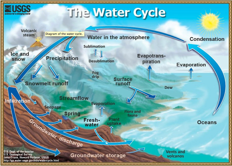
According to NASA, rising temperatures will intensify the Earth’s water cycle, increasing evaporation. This increased evaporation will result in more storms, but also contribute to drying over some land areas.
As a result, storm-affected areas are likely to experience increases in precipitation and increased risk of flooding, while areas located far away from storm tracks are likely to experience less precipitation and an increased risk of drought.
In the U.S., the study found the dry areas of the western U.S. are expected to become even drier.
From Climate Central (Andrea Thompson):
A new study that does just that suggests that Earth’s rain belts could be pushed northward as the Northern Hemisphere heats up faster than the Southern Hemisphere. That shift would happen in concert with the longstanding expectation for already wet areas to see more rain and for dry ones to become more arid.
The study, detailed Wednesday in the journal Science Advances, “adds to the large body of evidence that climate change is going to mess with the large-scale motions of air and water in the atmosphere. And this matters, because those patterns largely determine where it’s rainy or arid, broadly speaking,” NASA climate scientist Kate Marvel, who wasn’t involved with the study, said in an email.
These changes in rain distribution could have implications for future water resources, particularly in areas where water supplies are already stressed, such as the western U.S. and parts of Africa.
From the basic physics of the atmosphere, scientists expect that as the planet heats up from ever-mounting levels of greenhouse gases, net global precipitation will increase because a warmer atmosphere holds more moisture. But that increase won’t be uniform and is likely to be concentrated in the already moist tropics. And because higher temperatures also increase evaporation, other areas, such as the already dry subtropics, are likely to dry out further.
But which regions are wet and dry are also determined by the locations of the Earth’s main rain belts. The positions of those rain belts, in turn, are tied to that of the so-called thermal equator (the ring around the planet’s middle where surface temperatures are highest). And the location of that equator is impacted by the balance of temperatures between the Northern and Southern hemispheres.
Because the Northern Hemisphere has more landmass, it is heating up faster than the Southern Hemisphere, and, as some climate models have suggested, this could push the thermal equator northward, and along with it those key rain belts.
Aaron Putnam, a paleoclimatologist at the University of Maine, and Wally Broecker, a Columbia University climate scientist, looked for clues as to whether such shifts have happened before in various paleoclimate records, including the shorelines of ancient lakes and cave stalagmites.
The lakes they examined are so-called closed-basin lakes, which have rivers feeding into them, but not draining them, meaning that changes in lake levels are governed solely by precipitation and evaporation.
During the Last Glacial Maximum when the Earth was much colder, closed-basin lakes in currently dry parts of western North America, the Middle East and South America were much larger than they are now, as evidenced by radiocarbon dating and other testing of their ancient shorelines. The precursor of Utah’s Great Salt Lake, for example, was more than 11 times larger than the current lake.
Studies of the dynamics of these lakes point to increased precipitation in these regions as the likely reason these lakes reached such massive extents. This suggests more precipitation fell away from the tropics in a colder climate, the opposite of what is expected as the world warms.
Those same lakes, along with other evidence from around the world, also points to the shifting of rain belts after a rapid loss of Arctic sea ice about 14,600 years ago that saw the Northern Hemisphere heat up faster than the Southern.
Layers of sediment off the coast of South America, for example, show changes in the amount of rain-fueled river water dumping into the ocean, while cave stalagmites, which need an influx of mineral-laden rainwater to grow, also show changes in precipitation over time.
These and other paleoclimate records indicate that rain belts shifted northward along with the thermal equator because of the global heat imbalance. Over the western U.S., for example, the Pacific subtropical jet went from providing moisture to southern California and the Great Basin during the glacial era to dumping it over northern California and Oregon as it does today.
While the warming happening now has a different cause than the past periods they studied, the authors think this past change could be a guide to the future and that same Pacific subtropical jet could move further north still.
Kevin Trenbeth, a climate scientist at the National Center for Atmospheric Research in Boulder, Colo., said the study didn’t account for changes in sea surface temperatures, which are the main drivers of changes in the position of the rain belts (as is seen during an El Nino event, when Pacific warming pushes the subtropical jet over the Western U.S. southward). Trenberth was also not involved in the study.
Putnam said the study was more focused on how the difference in warming between the hemispheres impacted the rain belts.
The changes in rain dynamics could also depend on the seasons, as climate records over recent decades suggest that the difference in heating between the two hemispheres is most pronounced during the Northern Hemisphere, or boreal, winter.
What this could mean, the authors posit, is that as the boreal winter continues to warm disproportionately, the thermal equator and therefore the rain belts won’t travel as far south as they currently do during the winter. This could have major impacts on areas, such as the western U.S., which get the bulk of their rain during the winter.
Conversely, in the boreal summer, when the difference between the two hemispheres isn’t as great, the “wet get wetter, dry get drier” effect of warming will dominate, meaning more rain in the tropics and less in the subtropics.
Of course, like any single study, this one is far from the final say. “This will evolve,” Putnam said, as more paleoclimate records emerge and are paired with climate models to “try to see if climate models can reproduce the patterns that we see in those datasets.”
From The Grand Junction Daily Sentinel (Dennis Webb):
Energy companies have inspected thousands of local oil and gas flowlines near homes and provided the state with an inventory of the lines following an order to complete those tasks, and now face a second deadline to test those lines.
The companies are responding to a directive by the Colorado Oil and Gas Conservation Commission after investigators determined that an April explosion that killed two people in a home in Firestone was caused by gas emitting from a flowline from a nearby oil and gas well. The line had been abandoned but never was disconnected from the well or capped, and was somehow severed near the home. Flowlines connect oil and gas wells to tanks, larger gathering lines that collect gas from multiple wells, or other equipment.
Based on a directive from Gov. John Hickenlooper, the oil and gas commission required that by Tuesday of this week, companies inspect any flowlines and other pipelines within 1,000 feet of a building unit and provide the commission with flowline inventory and location data.
Companies also had to take steps including making sure that all flowlines not in use, regardless of distance from buildings, are marked and capped.
Under the second phase of the order, with a June 30 deadline, companies must pressure-test all lines within 1,000 of buildings, and take steps including properly abandoning or removing any lines not in use, or putting them back in use after testing them.
Laramie Energy, with close to 1,300 producing wells in western Colorado’s Piceance Basin, identified about 900 flowlines closer than 1,000 feet from buildings. Local Laramie official Chis Clark noted by email that the definition of flowlines under the order “was very broad and included lines which normally would not be accounted for such as water lines and low pressure dump lines.”
He said that in addition to a gas flowline, a typical well may have an additional four to six lines “for produced liquids, fresh water, fuel gas or chemical treatment lines.”
He said of 899 lines identified under the inventory, 43 will be abandoned or removed by the June 30 deadline, and the rest pressure-tested.
A number of the Laramie lines within 1,000 feet of buildings are in the Collbran or Rifle areas. But Bob Hea, executive vice president and chief operating officer of Laramie, said the company’s holdings are still generally in fairly rural areas, and not near towns.
Terra Energy Partners submitted inventories to the state Tuesday on more than 2,700 flowline segments meeting the criteria for building proximity under the first phase of the state’s order.
Terra is the largest gas producer in the Piceance Basin, operating several thousand wells.
Complying with the state’s order has been no small task for Terra or Laramie.
“The large quantity of flowlines in our inventory required a substantial effort on the part of Terra employees to meet the deadline and was only possible by beginning with an already well-maintained database,” said Terra spokesperson Susan Alvillar.
She said Terra has more than 15 crews working to comply with the phase-two requirements.
“We meet challenges from a regulatory standpoint every day in our work and this effort is no different,” she said.
Hea said Laramie has hired contractors to help it with its compliance effort. He said the company began work within a day or two after the order came out and worked some long days to meet the first deadline.
He said the second phase will be a different kind of challenge. The company ordered digital pressure gauges that can record data, which will help it in carrying out pressure tests and providing results to the state. Doing the tests will probably involve an even greater workload than the first phase of the state’s order did, he said.
“Some lines require 15-minute tests, some lines require one-hour tests, and you can only do so many at a time,” he said.
He said the first-phase work turned up no surprises with the company’s lines. Most are fairly new, and either were put in by Laramie, or involved wells that it purchased from companies whose local employees it ended up hiring, so it already knew about most of the lines.
Don Simpson, a vice president with Ursa Resources, said it’s already nearly finished with the second phase of the required flowline work.
“We found no problems with any of our pipelines or anything like that,” he said.
He didn’t know offhand how many of its lines fell within the 1,000-foot building threshold. Ursa has fewer wells than some other local energy companies but has drilled closer to homes in places such as the Battlement Mesa area.
Much of Ursa’s drilling in that area is fairly new, so it had a lot of its flowlines identified already, Simpson said.
It also has wells in the Silt area, including ones that it acquired when it bought Antero Resources’ Piceance Basin assets years ago. While some of the Silt-area wells are older, Simpson said Ursa doesn’t have abandoned wells or abandoned flowlines, such as the line at issue in the Firestone explosion.
Information wasn’t available from the oil and gas commission as of late afternoon Wednesday about the level of compliance by companies with the first phase of the flowline order.

Here’s a report from Adam McCoy writing for The Colorado Statesman. Click through and read the whole article. Here’s an excerpt:
The U.S. Environmental Protection Agency under Scott Pruitt and the Army Corps of Engineers wrote a letter earlier this month to Colorado asking for written feedback on the state’s “experiences and expertise” as the agencies work to redefine the Waters of the U.S. Rule (WOTUS).
WOTUS, also known as the Clean Water Rule, defines the jurisdiction of the EPA over waterways and wetlands “to restore and maintain the chemical, physical, and biological integrity of waters of the United States.”
[…]
A Feb. 28 executive order signed by President Donald Trump directed the EPA and Army Corps to review the rule and ensure it prioritizes that the “nation’s navigable waters are kept free from pollution, while at the same time promoting economic growth, minimizing regulatory uncertainty, and showing due regard for the roles of the Congress and States under the Constitution.”
[…]
State preparing comment
The governor’s office said in a statement to The Colorado Statesman, it is in the process of developing comments in reply to the EPA.
“It is important to Colorado that a revised rule provide clarity so that projects are able to proceed efficiently, and that the rule be legally defensible,” spokesperson Jacque Montgomery said. “It is also important that the rule protect the headwaters of Colorado and retain the agricultural exemptions.”
U.S. Rep. Scott Tipton, R-CO3, has voiced support for the WOTUS redefining effort, urging Hickenlooper and Colorado Attorney General Cynthia Coffman to weigh in with feedback.
“We all want access to clean and reliable water supplies. This is why the Clean Water Act was signed into law in 1948 and expanded in 1972,” Tipton said in a statement. “What we don’t want is for unelected bureaucrats to legislate through rulemaking. This is what the EPA did with WOTUS, and Colorado responded by joining several other Western States in a lawsuit against the rule.”
Coffman’s office said it has not received any correspondence from the EPA or the Army Corps of Engineers.
The Scalia opinion
The letter to state officials across the country said the order will be enacted in two steps including re-codifying the Clean Water Act before WOTUS, and writing a replacement act that aligns with an opinion written by Justice Scalia in a legal challenge.
That refers to an opinion coming out of a dispute between a Michigan farmer and the EPA over development on a wetland. It was heard by the U.S. Supreme Court in 2006 and the case questioned whether the EPA has jurisdiction over bodies “that do not even have a navigable water,” according to the Congressional Research Service.
In a plurality opinion written by Scalia, the justice argued the word “waters” in “waters of the United States” refers to “relatively permanent, standing or continuously flowing bodies of water.” Scalia was pointing to streams, rivers and lakes and wetlands that have a “continuous surface connection,” the research service wrote.
The nation’s highest court was expected to provide clarity on the EPA’s jurisdiction, but instead couldn’t come to a consensus on a standard.
Impact in Colorado
The Army Corps of Engineers and EPA face the challenge of how to combine the best watershed science into an effort to define federal jurisdiction that provides clarity to regulators and those facing regulations, said Reagan Waskom, director of the Colorado Water Institute.
“As scientists, we see that everything in the watershed is connected at some level, so the challenge is defining what is ‘significant’ in the significant nexus,” he said, referring to a different Supreme Court opinion from Justice Anthony Kennedy that argued the Army Corps should judge on a case-by-case basis whether a body of water has “significant nexus,” or significant impact, on a navigable water.
“We also view the landscape as highly heterogeneous and see case-by-case evaluation as the most likely approach to get it right (from a scientific point of view),” Waskom said.
He said the Scalia approach overlooks the science and “may have trouble withstanding court challenges from citizen-initiated lawsuits.”
Waskom said farmers and developers deserve regulatory certainty, and know the rules when it comes to managing their land and development projects, but there won’t be much impact on Colorado agriculture.
“Here in Colorado, I think agriculture would generally have been in the same position as before with the Clean Water Rule as promulgated as we do not have any of the five categories of ‘isolated waters’ called out for expanded jurisdiction,” he said.