Summary
The 2018 water year has been off to very dry start across Colorado, with the southern half of the state receiving notably less precipitation than the northern half. As of January 5th, the statewide snow water equivalent (SWE) was the second lowest on record. There is a wide range of snowpack levels across the state, from a low of 23 percent of normal in the combined San Miguel, Dolores, Animas, and San Juan basins to a high of 87 percent in the North and South Platte basins, with the statewide SWE being 54 percent of normal. These same spatial trends exist in water year-to-date precipitation values with an even broader spread. The aforementioned basins of southwest Colorado have received 19 percent of average precipitation since October 1st and the South Platte has received 102 percent, with the entire state averaging out at 59 percent of average. Given the dry conditions to date, it is generally viewed as good news that all major river basins in the state are currently holding above average reservoir storage. Of particular note is the Rio Grande basin which has only 29 percent of normal snowpack but despite having been below the long-term average for the vast majority of time since 2001, has now had above average reservoir storage since last June. Streamflow forecasts largely reflect the spatial patterns observed on precipitation and accumulated snowpack, with forecasts being much lower in the southern half of Colorado and higher in the north. That said, currently all streamflow forecasts in the state of Colorado are for below average spring and summer volumes.
Snowpack
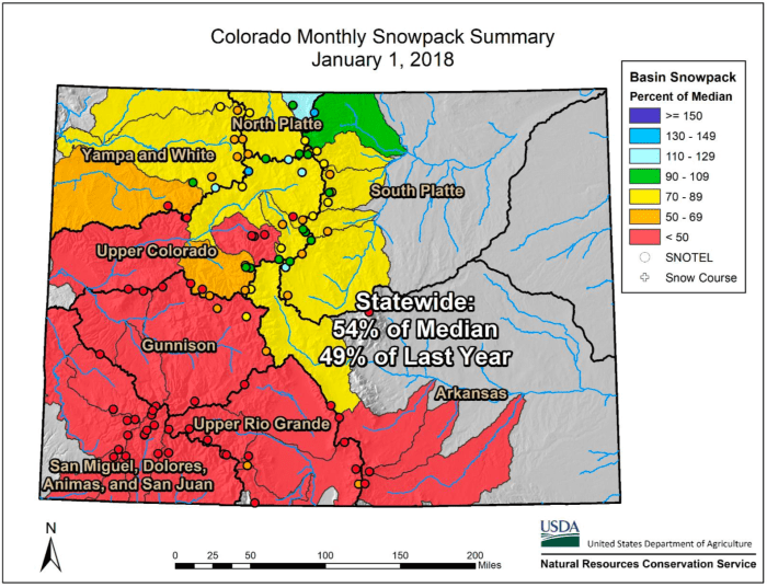
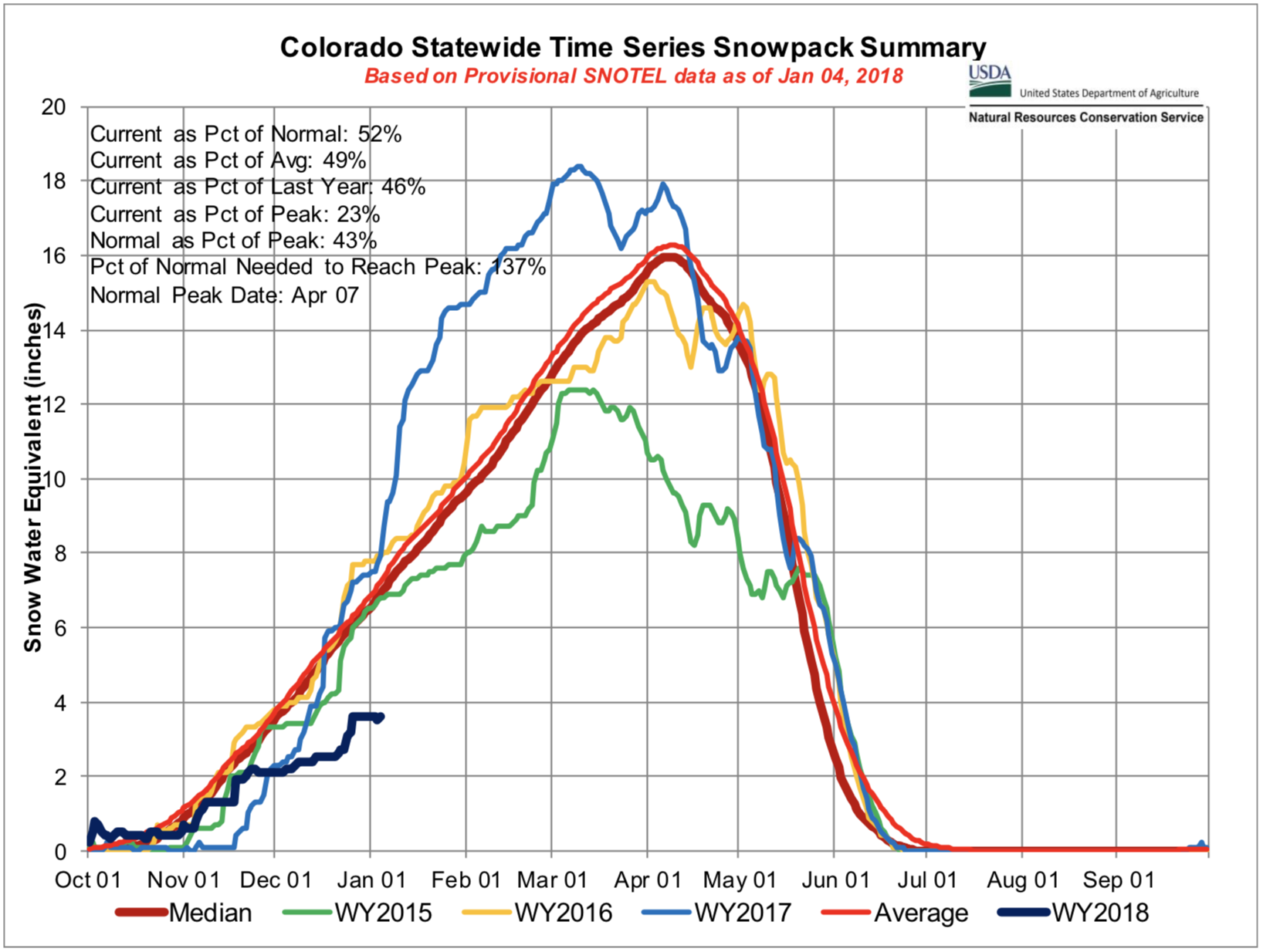
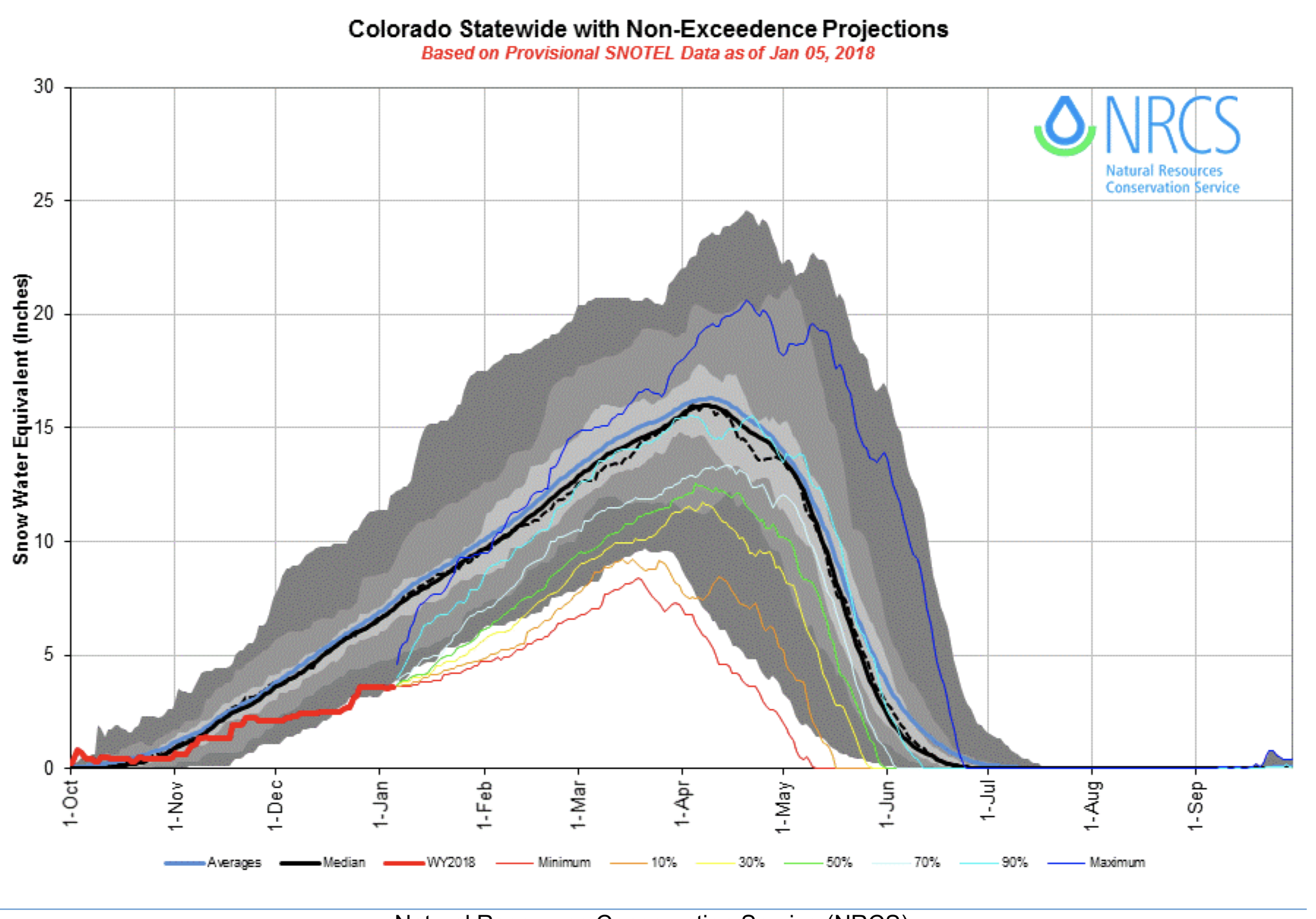
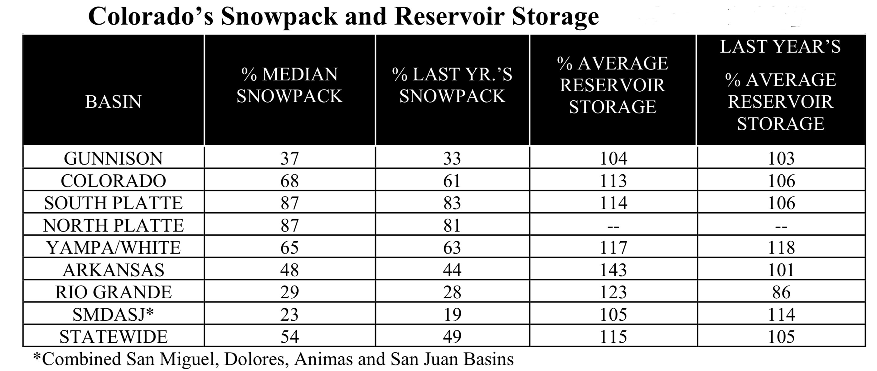
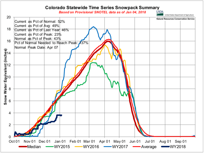
The snowpack across most of Colorado’s mountains is at dismal levels after a dry start to the accumulation season. On January 1st, 34 of the 104 SNOTEL sites with at least 10 years of data collection had record low snow water equivalent (SWE) amounts, another 13 had the second lowest SWE accumulations, and about 90 percent of sites were reporting a snowpack below median levels. Almost half of river sub-basins in Colorado are below 50 percent of normal snowpack, with most of these drainages concentrated in the southern portion of the state. Additionally, four of the seven major river basins are below 50 percent of normal, and all are below 90 percent of the median for January 1st. The combined San Miguel Dolores, Animas, and San Juan River basins have the lowest snowpack, with respect to normal, and collectively have only accumulated 23 percent of median snowpack for January 1st. The other southern basins are also experiencing low-snow conditions, with the Upper Rio Grande and Gunnison River basins at 29 and 37 percent of the median respectively, and the Arkansas at 48 percent of median, bolstered mainly by higher accumulations in the northern reaches of the basin. Snowpack conditions improve slightly moving northward, where the combined Yampa and White River basins are at 65 percent of the median and the Colorado River basin is at 68 percent. The South Platte and North Platte, the northernmost basins east of the Continental Divide, contain the best snowpack, with respect to normal, and are both at 87 percent of the median. With about half of the snow accumulation season still ahead of us, there is still time for conditions to improve across the state. However, only about three months remain until Colorado’s mountains typically reach their peak snowpack for the year, so the foundation that has been set does not provide a promising outlook for universally abundant snowmelt runoff this spring.
Precipitation
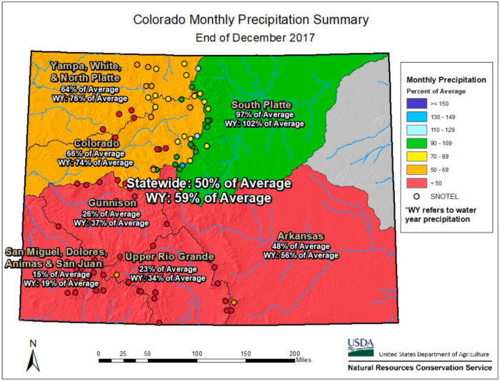
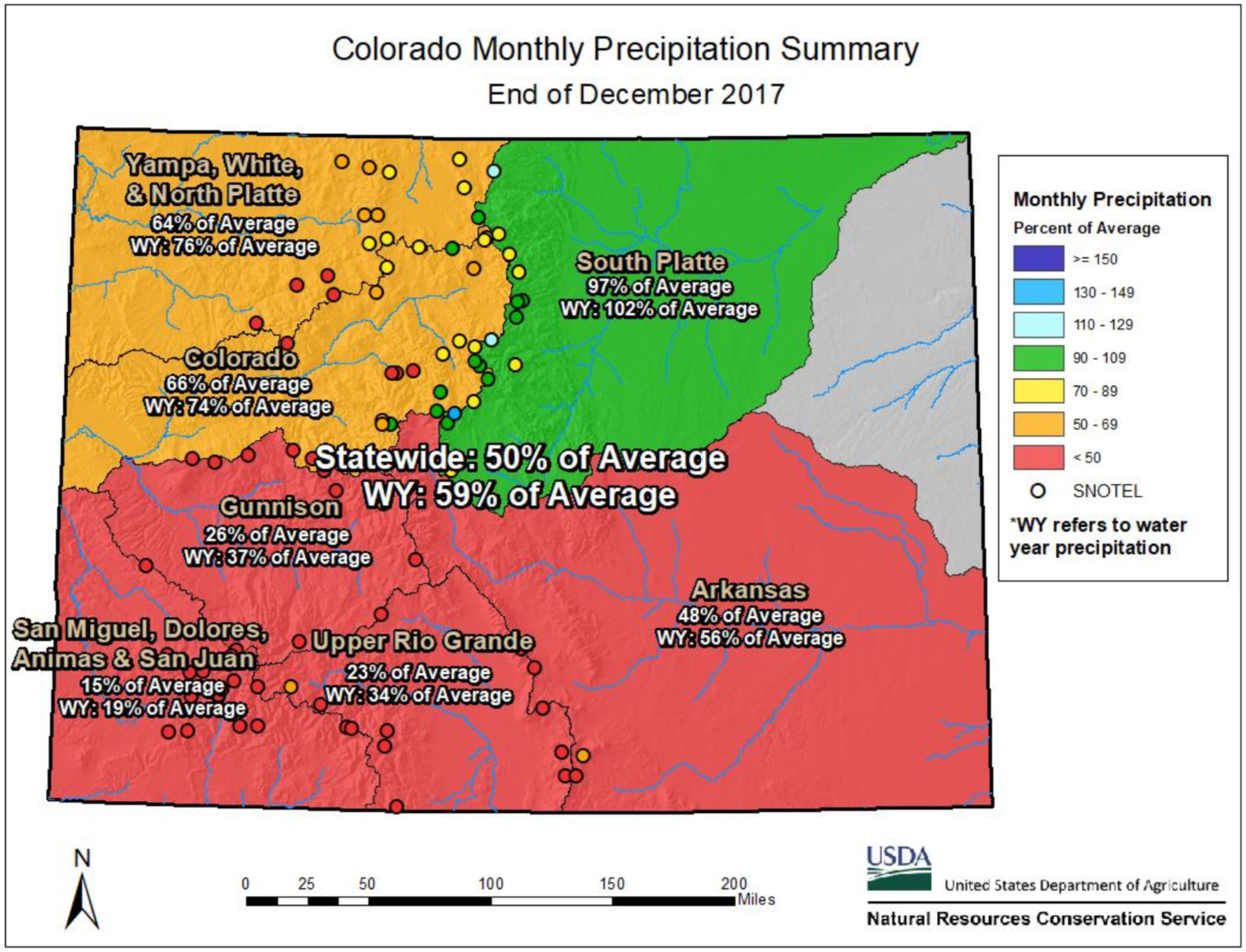
Dry conditions have dominated the 2018 water year for most of Colorado’s major river basins. The majority of storm events reaching the state have skirted the southwest basins almost entirely. The combined San Miguel, Dolores, Animas, and San Juan River basins have not exceeded 25 percent of average for a single month since the water year began on October 1st. Currently SNOTEL stations in those basins have received on average only a meager 2.1 inches of precipitation since October, bringing the basins to only 19 percent of average water year precipitation. The Upper Rio Grande and Gunnison River basins have not fared much better, and have remained below 50 percent of average monthly precipitation for each month this water year. These basins are currently at 34 and 37 percent of average, respectively, for year-to-date precipitation. The Arkansas River basin has received only slightly better precipitation accumulations since this fall, and water year-to-date precipitation is currently at 56 percent of average. The Upper Colorado and combined Yampa, White, and North Platte River basins are also well-below average at 74 and 76 percent of average, respectively, for the water year. The South Platte River basin is the anomaly in Colorado so far this year, and is currently at 102 percent of average for the water year. Ample precipitation in October, at 117 percent of average, provided the South Platte River basin a good start to water year, and subsequent months have remained only slightly below normal. Regardless, statewide precipitation is only at 59 percent of average for water year-to-date and Colorado’s mountains have a lot of catching up to do to bring the statewide precipitation to near normal levels.
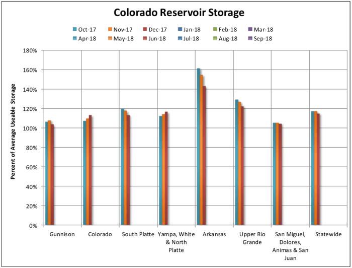
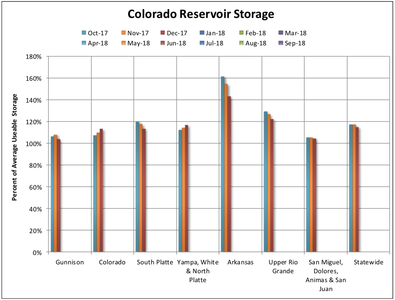
While the 2018 water year has been off to a very dry start, Colorado reservoir storage has remained above average in every major river basin for the last three months. These values range from a low of 104 percent of average in the Gunnison basin to a high of 143 percent average storage in the Arkansas basin. Statewide reservoir storage was 115 percent of average as of January 1st. These above average storage volumes may be particularly important in the Rio Grande, San Miguel, Dolores, Animas, and San Juan basins of southwest Colorado where snowpack and water year precipitation have been by far the lowest in the state. These storage levels come at a critical time to the Rio Grande, in particular, because with the exception of one spike in 2009 this basin has had below average storage levels since 2001, until last June when they finally reached above average levels and have remained so ever since. The basin is holding 123 percent of average storage as of January 1st. While still holding 105 percent of average reservoir storage the combined basins of southwest Colorado appear to be in a slightly more precarious situation at this point in the season because this region only has 23 percent of normal snowpack compared to the slightly higher 29 percent of the Rio Grande. Current streamflow forecasts for both areas are well below normal, so without a substantial increase in precipitation that reservoir storage will become critical this summer. The South Platte, Colorado, and combined Yampa, White, and North Platte basins are all holding between 113 and 117 percent of average reservoir storage.
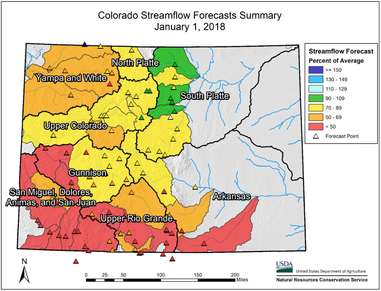
Streamflow
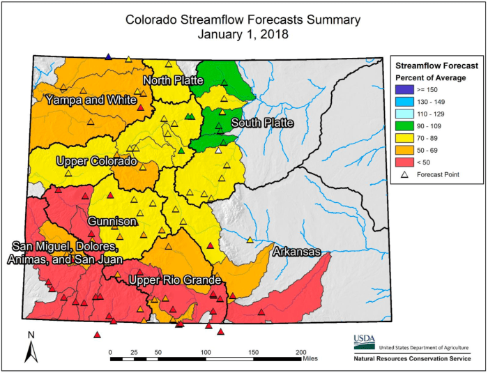
The current range of streamflow forecasts do not provide an optimistic outlook for superfluous runoff in Colorado this spring. Drastically below normal snowpack and precipitation, particularly in the southern half of the state, have caused forecasted streamflow volumes for most forecast points to fall below normal for all but the lowest exceedance probabilities. This indicates that although there is still much uncertainty in forecasts this early in the water year, conditions are such that changes are not likely to be drastic enough to elicit near normal streamflow volumes. However, there is a wide range of forecasted streamflow volumes for gages across Colorado, and there are several forecast points in the northern river basins that have a higher probability of reaching normal streamflow volumes. Following the trends in snowpack and precipitation, the bleakest April through July streamflow volumes are anticipated for the Upper Rio Grande and combined San Miguel, Dolores, Animas, and San Juan River basins. Here, the entire suite of forecasts fall below normal. Therefore, if current conditions prevail, there is less than a 10 percent probability of reaching normal flows at all but two forecast points and the 50 percent exceedance forecasts are calling for flows ranging from 28 to 63 percent of average. Forecasts in the Gunnison River basin are for similarly low volumes, ranging from 33 to 78 percent of normal. Many forecasts in the Colorado and combined Yampa and White River basins are also well below normal. Forecast points on some tributaries do have a better outlook, leading to a wide range of anticipated streamflows, from 45 to 92 percent of average. Forecast points in the North and South Platte River basins are the most likely to achieve normal flows given current snowpack and precipitation conditions and range from 73 percent to 94 percent of average. There is still time for a positive change to water supply conditions, but it would be wise to start planning for below normal runoff across much of Colorado.