
Day: January 2, 2018
The Southwest faces water challenges and choices in dealing with #ClimateChange
From The New Mexico Political Report (Laura Paskus):
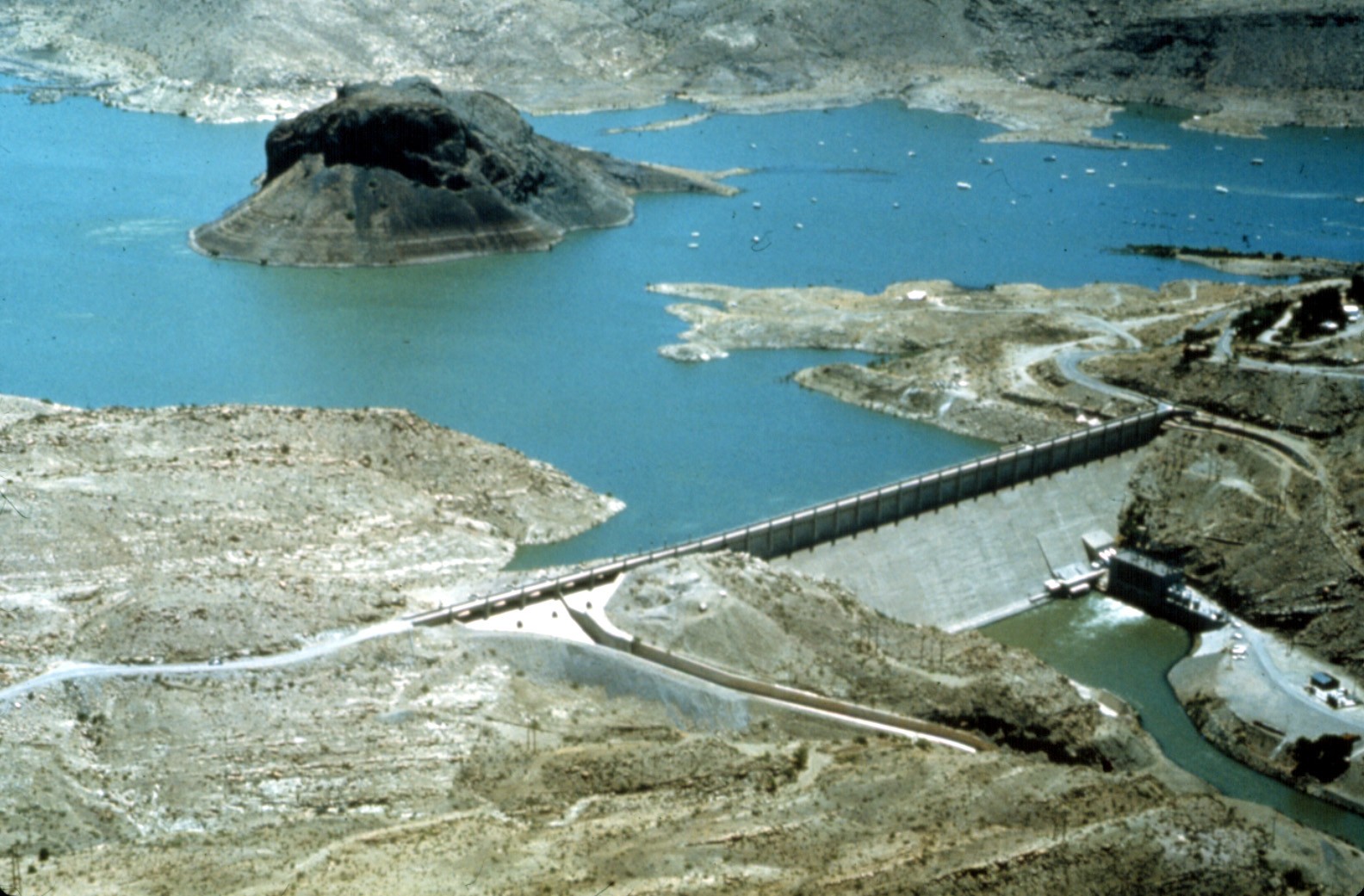
“I’m openly skeptical we’ll ever be able to fill Elephant Butte Reservoir again,” Dr. David Gutzler told attendees of a recent climate change conference. That’s given the trend toward diminished flows in the Rio Grande resulting from the continued global rise in temperature.
The University of New Mexico Earth and Planetary Studies Department professor delivered the grim news on a crisp, yellow and blue fall morning along the bosque in Albuquerque.
Since the U.S. Bureau of Reclamation completed the reservoir in 1916 to supply farmers in southern New Mexico and Texas with water, the reservoir’s levels have fluctuated—from highs in the 1940s to lows in the 1950s, ‘60s, and 70s. Many New Mexicans are familiar with the wet period that lasted from 1984 through 1993; between 1980 and 2006, the state’s population increased by 50 percent. But then the region was hit with drier conditions—and increasing temperatures. Areas of the Southwest have suffered from drought since 1999 and, unlike earlier droughts, it’s driven not just by a lack of precipitation, but a rise in temperature.
Even with good snowpack in southern Colorado and northern New Mexico the past few years, there simply isn’t enough water to boost the reservoir’s levels again, said Gutzler, who is also one of the lead authors of the Intergovernmental Panel on Climate Change’s 2013 Assessment Report. The reservoir is currently at just 15 percent capacity…
Warming in the American Southwest is occurring at about double the global rate—and that local warming will have a profound impact on water resources in the Interior West. Those changes in water supply will occur regardless of changes in precipitation, he said.
Gutzler added, “There is nothing the slightest bit hypothetical about this warming.”
On Friday, the U.S. government released its Climate Change Special Report and the fourth volume of the National Climate Assessment, an update of the last report released in 2014. It’s the culmination of work by 13 federal agencies mandated by Congress to assess climate science and climate change impacts every four years.
Pagosa Springs geothermal project yields knowledge and vegetables

From The Durango Herald (Mary Shinn):
After about a year of gardening in a dome on the banks of the San Juan River in Pagosa Springs, the Geothermal Greenhouse Partnership plans to start construction on two more domes this spring.
Residents began planning the growing spaces in 2008 and 2009 during the Great Recession as a way to revitalize the town’s historic downtown. The vision was to provide an educational and growing space for all ages and demonstrate geothermal energy, said Sally High, the president of the nonprofit’s board of directors…
In addition to drawing in the public, it has also produced a bountiful harvest with thousands of tomatoes, leafy greens and other vegetables. The dome, 42 feet in diameter, produced enough bounty to sell at the farmers market in its first year, she said.
In the next phase of construction, the nonprofit plans a dome to house a community garden and an innovation dome, which will be used to demonstrate aquaponics – a hydroponic system that incorporates fish to help feed the plants, High said.
Construction of the new domes this spring will be funded by a $174,500 grant from the Colorado Water Plan Engagement and Innovation Fund and a $34,000 matching grant from the Colorado Garden Foundation.
When complete, the final cost of the project could be between $800,000 and $1 million, High said.
<
#Snowpack news: #Colorado statewide SWE is heading downward
Click on a thumbnail graphic to view a gallery of snowpack data from the NRCS.

Statewide snowpack basin filled map January 2, 2018 via the NRCS.

Statewide Basin High/Low graph January 1, 2018 via the NRCS.

Arkansas River Basin High/Low graph January 1, 2018 via the NRCS.

Upper Colorado River Basin High/Low graph January 1, 2018 via the NRCS.

Gunnison River Basin High/Low graph January 1, 2018 via the NRCS.

Laramie and North Platte Basin High/Low graph January 1, 2018 via the NRCS.

Upper Rio Grande River Basin High/Low graph January 1, 2018 via the NRCS.

San Miguel, Dolores, Animas, and San Jiuan Basin High/Low graph January 1, 2018 via the NRCS.

South Platte River Basin High/Low graph January 1, 2018 via the NRCS.

Yampa and White Basin High/Low graph January 1, 2018 via the NRCS.
And here’s the Colorado January 2, 2018 snowpack by sub-basins from the NRCS.

From The Summit Daily News (Allen Best):
With the ground mostly brown just a few days before Christmas, some residents of Telluride gathered old skis and burned them in an offering to Ullr, in Norse mythology the god of snowshoes and some other items. The next day it snowed 4 inches at Telluride, reported the Daily Planet.
Coincidental or causal? Whatever. The San Juan Mountains have been so barren that just four inches was tantamount to a big dump in some winters.
Since then, a Christmas Eve storm left most of Colorado white. There was enough snow along the Continental divide in the Breckenridge to Winter Park area that avalanche forecasters warned backcountry skiers to definitely stay off slopes of more than 30 degrees…
But the blanket of snow across Colorado was not uniform. Telluride got just an inch, while Steamboat Today reported the local ski hill got 24 inches in two days. Ski areas in Montana and Wyoming did better.
In California, there was even less cause for holiday snow-white joy. There was no mistaking the Tahoe area for the North Pole at Christmas reported the Reno Gazette-Journal. “The mountains were patchy with snow all the way up, and the only snow falling as that made by the ski resorts.”
[…]
The problem for Colorado is the same as the problem for California: a persistent high-pressure ridge that has shunted moisture-laden storms northward. This has produced “almost inconceivably heavy snowfall in the coastal mountains of southern Alaska,” explained Daniel Swain in a Christmas Eve posting on the California Weather Blog.
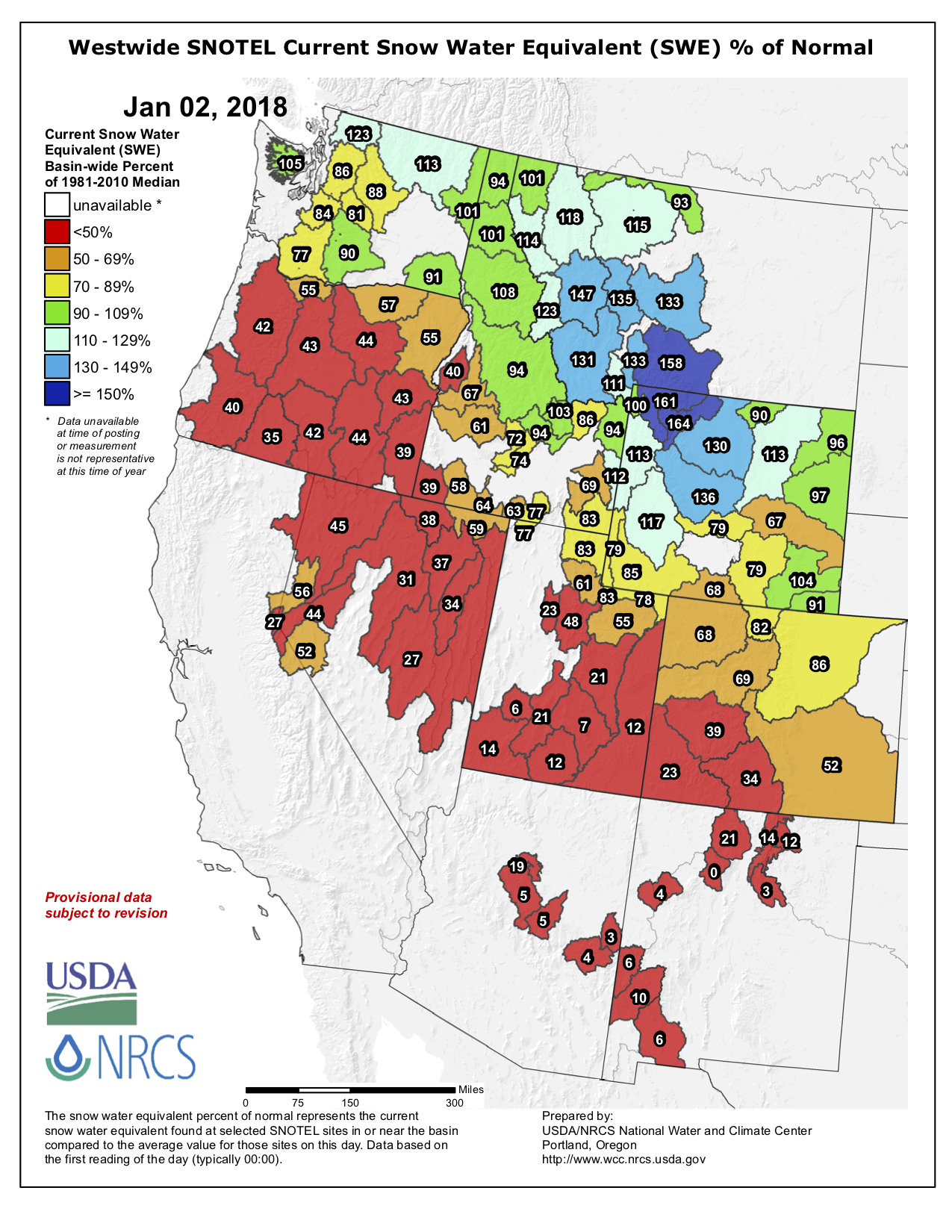
Finally, here’s the Westwide SNOTEL map for January 2, 2018.
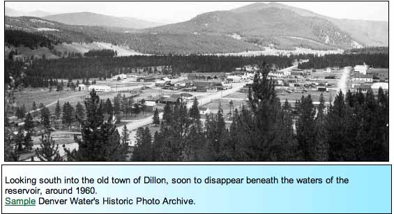
Dillon Reservoir still mainly ice-free for this season
From CBS Denver (Matt Kroschel):
Warmer temps have left Dillon Reservoir for the most part unfrozen, typically the large body of water freezes over by the end of December. Not this year, though.
More dry weather and above average temperatures are predicted for the next few days. That leaves open the possibility of breaking the record this year.
2017 in natural disasters — @HighCountryNews
Here’s a look back at 2017 from Emily Benson writing for The High Country News:
By Emily Benson, The High Country News
A variety of natural forces — floods, fires, droughts and more — pounded the West in 2017, many of which are intensifying thanks to climate change. The year also saw an influx of evidence that humans have altered the earth’s climate so much that certain severe weather events would not have been possible in a pre-industrial world. “It’s quite bold for scientists to make these very strong statements,” says Andrew King, an expert weather and climate at the University of Melbourne in Australia. That unflinching stance from researchers suggests that 2017 may have been a turning point in their confidence in the links between climate change and specific disasters. “For scientists to say that an event would be virtually impossible without climate change — they’re very sure.” We rounded up some of the most notable climate and weather events that rocked the West:
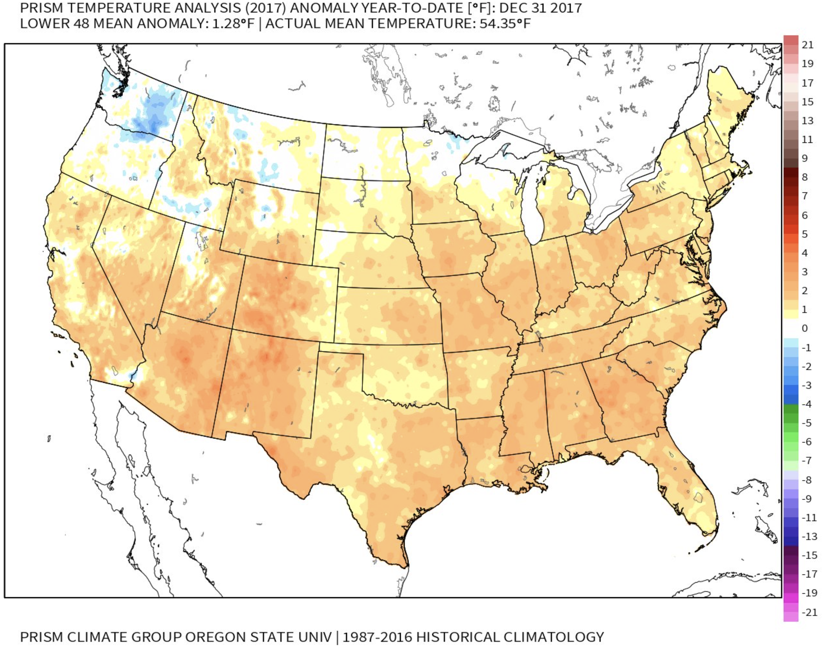
Hot weather broke records
While scientists don’t expect 2017 to beat out 2016 as the hottest year on record (though it will likely be among the top three), several Western states broke monthly heat records in 2017. Colorado and New Mexico experienced the warmest March in each state’s history. Along the Pacific coast, California, Oregon and Washington set records for the hottest August on the books. Autumn scorched the Four Corners states: Arizona, Colorado, New Mexico and Utah each broke its November heat record.

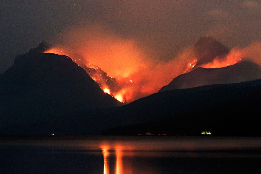
Fire spread smoke across the West
Wildfires raced across the West in 2017, with California hit particularly hard. The Golden State experienced the costliest, most destructive blazes in its history in October, when 44 people were killed and thousands of homes destroyed near Napa and Santa Rosa. Two months later, the Thomas Fire, now the state’s largest wildfire on record, started east of Santa Barbara on Dec. 4 and was still burning as 2017 came to a close.
In Montana, wildfires burned more than 1 million acres this year, filling the air with a haze of lung-damaging smoke, a problem that could get worse in the coming years. Scientists expect to see more fires and a longer fire season as temperatures rise across the West.
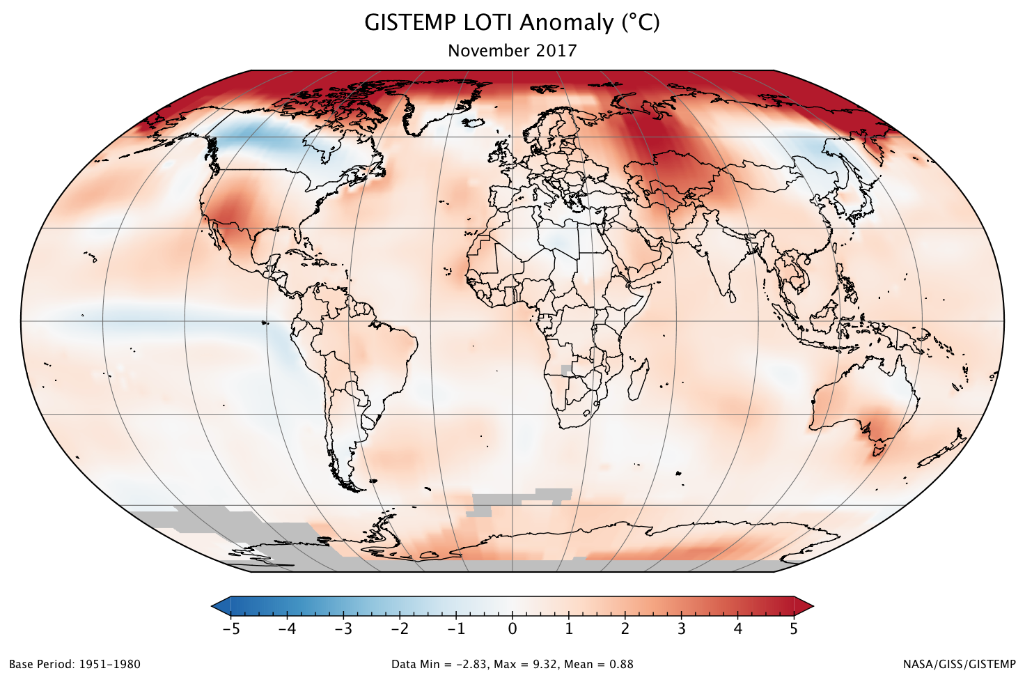
Arctic sea ice hit a new winter low
As the climate warms, the amount of sea ice in the Arctic is decreasing. Sea ice cover hits its maximum in March, when there’s typically two or three times as much ice as there is in September, after summertime melting. In March 2017, Arctic sea ice peaked for the year — and broke the record for the lowest winter maximum ever recorded.
That could drive changes far from the North Pole. In December, scientists from Lawrence Livermore National Lab published a study elucidating the link between Arctic sea ice loss and drought in California.
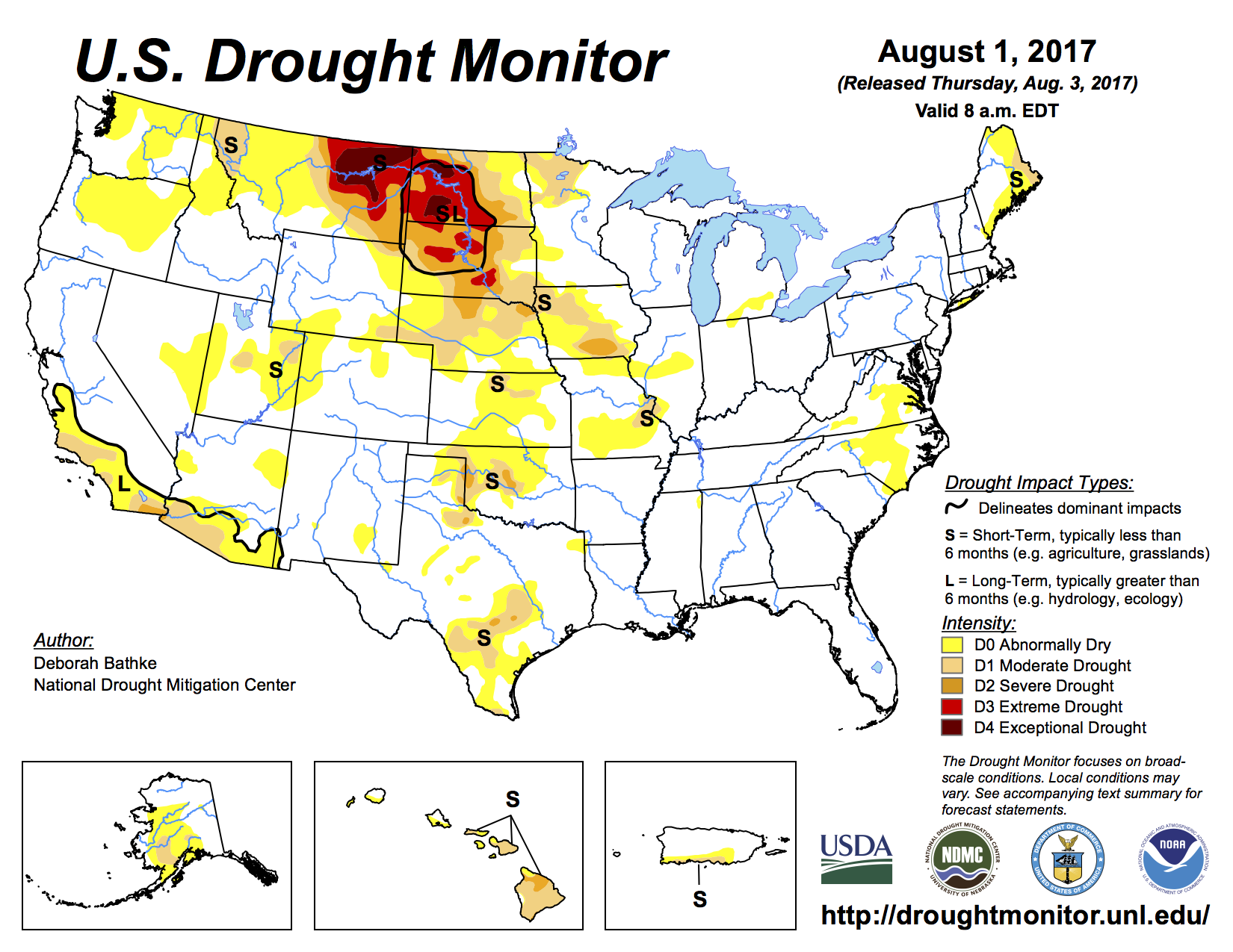
Drought swept the northern Rockies
This year’s fires were fueled in part by severe drought. Exceptionally dry conditions in the northern Great Plains began in the spring and lasted into the fall, decimating crops in parts of Montana and the Dakotas. The drought also left many pastures unable to support cattle. Fields were so parched that many ranchers were forced to sell their animals or rely on donations of hay to get by.
California storms brought relief and ruin
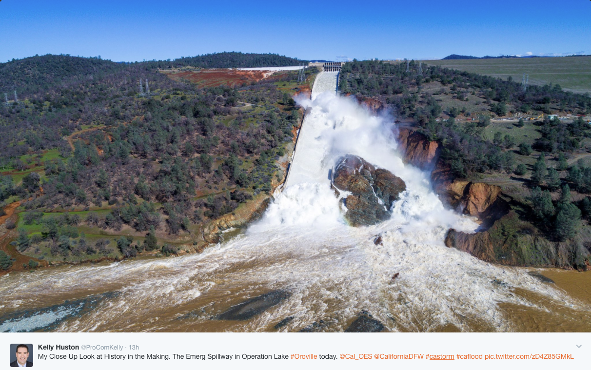
California’s latest drought was declared largely over in early April. But the deluges of winter rain along the coast that helped end the dry spell also brought destruction. Tens of thousands of people in San Jose evacuated due to flooding in February, some of whom were still displaced months after the disaster. And more than 180,000 people downstream of Oroville Dam were told to flee their homes on Feb. 12, when officials feared that damage to the dam’s two spillways could lead to a catastrophic, uncontrolled release of water. Though the reservoir walls held, preventing widespread flooding, repairs to the spillways are expected to cost more than $640 million.
California’s heavy rains also set off several landslides. In Big Sur, a major bridge was damaged beyond repair in February and sections of Highway 1, California’s iconic coastal route, were obliterated, leaving some communities inaccessible by car. The biggest slide, on May 20, blanketed a quarter-mile of the highway and created a new, 15-acre peninsula jutting into the ocean.

Colorado hailstorm smashed coffers
Rain wasn’t the only destructive weather that pummeled the West this year. On May 8, thunderstorms hit Denver, Colorado, and the surrounding area, walloping buildings and cars with hail the size of baseballs. More than 100,000 vehicles were damaged. The final price tag for the destruction wrought by the barrage was more than $1.5 billion, making it the state’s most expensive hailstorm ever.
Emily Benson is an editorial fellow at High Country News.
Please consider a donation or subscribing to The High Country News. Tell them Coyote Gulch sent you.
#CA: Urban designers are incorporating #reuse into building design
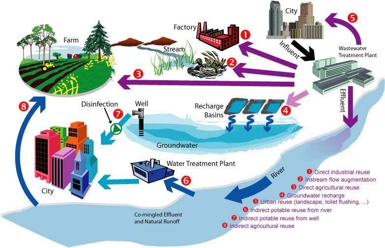
From Water Deeply (Tara Lohan):
San Francisco is helping to grow adoption of onsite nonpotable water reuse systems by requiring them in large new buildings. Now there is interest in a statewide regulation to streamline permitting while ensuring health and safety.
IN DOWNTOWN SAN Francisco, a mixed-use 800ft tower nearing completion at 181 Fremont St. features a water treatment system that will provide 5,000 gallons a day of recycled water captured from the building to be used for toilet flushing and irrigation. That will help save an estimated 1.3 million gallons of potable water a year.
Just down the street, the recently expanded Moscone Conference Center has installed a system to collect and treat foundation drainage, otherwise known as “nuisance groundwater,” that will be used for toilet flushing and irrigation as well by the city’s Department of Public Works for street cleaning.
Both buildings are among 82 proposed or completed projects in San Francisco that are using decentralized, onsite water-recycling systems to capture and reuse water that would otherwise flow down the drain or run off rooftops to city sewers or into the San Francisco Bay. The treated water that’s captured isn’t used for drinking, but for nonpotable purposes such as flushing toilets and urinals, irrigating landscapes, supplying cooling systems and even generating steam power. In commercial buildings, about 95 percent of water used is generally for nonpotable purposes. In multifamily residential buildings, it’s 50 percent.
As interest in recycled water grows in California and across the United States, more building professionals are considering these decentralized systems. Up until now, a lack of health and safety regulations at the national and state levels has made the permitting process tricky and slow going. But bottom-up pressure may help create needed regulations…
This process would be easier for communities if there were established health and safety standards from the state for onsite nonpotable reuse, but so far they’re lacking.
“We think that from our perspective, if there is clear guidance and regulations that the state establishes, it would make it easier for communities that want to pursue local programs to oversee and manage decentralized water systems,” said Kyle Pickett, managing principal at Urban Fabrick.
Those regulations could be on the way, but how long it will take is unclear…
While there are no national or state regulations for onsite nonpotable reuse yet, there is a growing community of professionals sharing resources and expertise. SFPUC’s Kehoe chairs a National Blue Ribbon Commission for Onsite Nonpotable Water Systems, which recently produced a guidebook on water quality standards and management of onsite reuse systems. The commission was established by the U.S. Water Alliance, and it convenes more than 30 water and health professionals from across the country…
Other efforts are underway, too. Urban Fabrick’s nonprofit arm, the William J. Worthen Foundation, will be releasing a practice guide on January 19 aimed at giving design professionals information about onsite reuse…
“We don’t do nearly enough water recycling in California, honestly, it’s embarrassing how far behind we are compared to Australia, Israel and other places with very arid environments,” said Wiener. “We have a long-term structural water shortage and we need to modernize our water system and drag it out of the 1850s. Water recycling is a critical aspect of modernizing our water system.”