Increased snowpack near the Wyoming-Colorado border could mean average water supply for the Laramie Valley this year, a National Oceanic and Atmospheric Administration representative said.
Despite below-average snowpack at the Laramie River’s headwaters in Cameron Pass, Colorado, NOAA Hydrologist Jim Fahey said Albany County’s water supply prediction was unusually similar to 2017’s…
Laramie Water Resources Administrator Darren Parkin said one reason the water supply is doing so well is an influx of precipitation around Dead Man Hill and Roach in Colorado near the Wyoming border.
“We were around 83 percent (of average water supply) on the Laramie River at the beginning of the month,” Parkin said. “Today, we’re at about 111 percent, so we’re tracking up.”
Only a small amount of the city’s water is supplied by snowpack in the Snowy Range, Parkin explained. Most of Laramie’s water comes from the headwaters of the Laramie River, which originate in Colorado around Cameron Pass, Chambers Lake and the Rawah Range.
While the city does not use reservoir storage, relying instead on groundwater wells on the Casper Aquifer in a time of drought, Parkin said Lake Hattie was about 67 percent full and Gray Rocks Reservoir near Wheatland was completely full, which would benefit Albany County’s agriculture industry.
FromThe Grand Junction Daily Sentinel (Dennis Webb):
The statewide snowpack reached 74 percent of normal as of Friday, according to the Natural Resources Conservation Service. That’s up sharply from 59 percent as of the start of the month.
Chris Cuoco, senior forecaster at the National Weather Service in Grand Junction, said basin-by-basin increases since Feb. 1 are even better than he’d realized until checking the data. They include:
■ The Yampa/White River basins, at 81 percent of median Friday, up from 72 percent.
■ The Upper Colorado River Basin, 85 percent, up from 75 percent.
■ The Gunnison basin, 63 percent, up from 48 percent.
■ The San Miguel/Dolores/Animas/San Juan basins, 55 percent, up from 36 percent.
■ The Upper Rio Grande basin, 59 percent, up from 35 percent.
“It’s a better increase than I would have thought, so that’s good — (up) to the tune of 20 percent down south, so that’s a pretty good jump,” he said.
Nevertheless, the snowpack deficit remains significant. Karl Wetlaufer, assistant snow supervisor for the NRCS Colorado snow survey program, says that with less than two months left in the typical snow accumulation season, the kind of snowfall needed to reach peak accumulation has happened only twice out of the last 36 years.
Klaus Wolter, a research scientist in Boulder with the National Oceanic and Atmospheric Administration and the University of Colorado, said the recent shift to a wetter weather pattern, while good news, is “a Hail Mary pass that’s not going to succeed. It’s not going to turn the game around.”
Abundant recent snowfall enabled Powderhorn Mountain Resort to return to a seven-day-a-week schedule this week. Resort spokesman Ryan Robinson said Powderhorn had gotten 6 or 8 inches for the day as of late afternoon Friday, 8 inches the prior 24 hours, and almost four and a half feet over the last two weeks.
But Wetlaufer said that even with the snowier weather of late, three automated snow measurement sites on Grand Mesa remained at record-low levels as of Thursday, based on records dating back 29 to 40 years, depending on the site.
A breakdown in a high-pressure ridge over the western United States has allowed storm systems to move through the state, particularly more to the south where snowfall has been meager this winter…
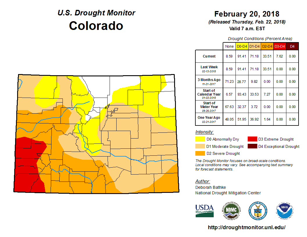
He noted that as of Tuesday, southwest Colorado was listed as being in extreme drought, with much of western Colorado in severe drought…
Both Wolter and Wetlaufer worry about a dearth of snow at some lower-elevation sites across the state…
And while Colorado has been blessed by some wet Mays in recent years, “I just don’t see the writing on the wall in that direction” this year, Wolter said.
The National Weather Service Climate Prediction Center currently is saying there’s a probability of both warmer and drier conditions than normal in Colorado over the next three months.
Meanwhile, Jeff Derry, executive director of the Center for Snow and Avalanche Studies in Silverton, is sounding another concerning note about this year’s snowpack.
At a field site on Red Mountain Pass, the center’s Colorado Dust-on-Snow program monitors weather events that blow dust onto Colorado’s mountains in the winter, which can accelerate melting once that dark dust layer is exposed to sunlight in the spring.
Derry wrote on the center’s website that winds gusting up to 83 mph out of the southwest early this week resulted in the first significant dust storm the center has observed this season.
“Because this event is more than a meter from the ground in the snowpack, we expect this event to have hydrologic consequences once exposed in the spring,” he wrote.
He said the dust-on-snow program team will begin statewide sampling tours in March to determine the extent and severity of the dust storm, “which is likely widespread with locales like Aspen Mountain reporting dust arriving on this storm front.”
2017 was a good water year and snowpack, but 2018 is shaping up to be a drought year. This and other statistics about weather patterns in the San Luis Valley were brought by Nolan Doesken, climatologist for the Colorado Water Institute at CSU, during the 2018 Southern Rocky Mountain Agricultural Conference. Doesken gave a presentation titled “Recent past weather and a look ahead.”
“You have this beautiful sunshine, yet you really want rain? I don’t understand you all,” joked Doesken. Doesken stated previous years had been okay to average with precipitation that local crops had responded to. This year is looking bleak in terms of water to be expected.
The weather in the Valley is “warmer in the summer and cooler in the winter,” according to Doesken. The Valley is also cooler than other parts of the state and is unique that it expands one of the largest areas of agricultural land in the United States.
“Last summer was a crazy wet year. It’s one of the wettest years we’ve ever seen down here,” said Doesken.
“Falls have been consistently warm for the last several years. You’ve probably noticed that. It’s quite interesting in that regard,” he said…
Doesken then addressed the trends in 2018. “We’re not doing very good,” he said. It is warmer than average temperatures this year. “Do you realize so far this year you’ve had two days where you were in the 60s?” So far 57 days in winter have had high temperatures of 57 or above. According to Doesken this has happened before— in 1981. Records show that was a drought year with no snow in the San Luis Valley.
The temperatures in the Valley are very variable said Doesken. This variance can be seen by simply comparing temperatures at the end of the day, aftertoon and early morning. “There has been days where there have been 50 and 60 degree swings in temperature…that is something you’re used to here but this year has been more extreme than most.”
Do you need to water the landscape in your yard during the winter? Absolutely yes! Just because some of your trees, shrubs and turf may look dead, they are not. They are dormant. Big difference.
I liken dormancy to when we sleep -— an analogy that would probably make my plant physiology professor cringe. There are still activities going on in our bodies while we slumber. We don’t temporarily die each night then wake up alive again the next day. There are two types of dormancy with woody plants. To learn more, read this online article by Michigan State University Extension: msue.anr.msu.edu/news/winter_dormancy_and_chilling_in_woody_plants…
Remember to water the entire drip line of large established trees. Their root systems are typically spread out to an amount equal to or greater than the height of the tree. A healthy plant is its own best defense against insect and disease issues, so water regularly during the winter to have happy plants in the summer.
Click here to view the announcement from the State of Colorado website:
Description of Job
This Water Commissioner position exists to ascertain available water supply and distribute, control and regulate the waters in Division 1 Water District 8, including portions of the South Platte River, Cherry Creek, Plum Creek and tributaries, on a daily basis pursuant to water decrees, state statutes, and substitute water supply plans. Additionally, under the direction of the Division Engineer, this position exists to record and compile permanent records of water diversions and use; disseminate and explain information pertaining to water availability and use to the public;; monitor dams for unsafe conditions,; investigate new water rights and change of use applications for potential injury to existing water rights; coordination and administration of transmountain diversions; administration of water rights that include large municipal, industrial and irrigation water users; coordination and administration of several reservoirs including Cherry Creek Reservoir and Rueter-Hess Reservoir, storage and releases; administration of daily exchanges; administration of numerous augmentation plans; and to serve as a guide and authority to water users. This position requires knowledge of the different types of water rights and the ability to disseminate this information as may be required. This position also reviews, creates and operates computerized spreadsheets and databases. Must be knowledgeable of water distribution and regulation, general understanding of Colorado Water Law, Division 1 accounting principles and basic dam safety inspection procedures and techniquest.
The South Platte River typically all but vanishes as it passes through Denver’s industrial neighborhood north of downtown, downstream of the Burlington Ditch diversion, near the Cherokee power plant. Photo/Allen Best
An acequia along the Las Trampas in northern New Mexico is suspended on a trestle. (Eddie Moore/Albuquerque Journal)
Sangre de Cristo Land Grant, La Sierra Common, and Subdivisions. La Sierra is the 80,000-acre common land or ejido. Map courtesy of High Country News at URL: https://www.hcn.org/issues/104/3250.
Maiz de concho growing at The Acequia Institute seed library patch, El Rito, CO. Photo by Devon G. Peña
Delmer Vialpando and Devon G. Peña on La Sierra common lands, the 80,000-acre restored land grant of the Culebra acequia farmers. Photo by The Acequia Institute
Selection of the 2015 native heirloom maize harvest of the seed library of The Acequia Institute in Viejo San Acacio, CO Photo by Devon G. Peña
Maíz de concho from Almunyah Dos Acequias.Viejo San Acacio, CO Photo by Devon G. Peña
Center-Pivot and Acequia Farms. The green belts along the Río Culebra and tributaries in San Acacio, San Luis, Chama, Los Fuertes and other unmarked villages are the principal acequia farm bottomlands in Costilla County. The center-pivot circles are concentrated in the Blanca-Ft. Garland vicinity to the N and the Mesita-Jaroso vicinity due W and SW of the acequia bottomlands. Source: Google Maps (screenshot).
The Upper Rio Grande/Rio Arriba Watershed (highlighting location of center-pivot sprinkler circles) Note: Green dots are center-pivot farm and ranch operations, most with junior groundwater withdrawal rights and subject to court-ordered mandates designed to mitigate damages to farmers with senior surface rights (including acequias) and to augment deliveries to the Rio Grande Interstate Compact. Source: NASA/MODIS files at: http://www.oneonta.edu/faculty/baumanpr/geosat2/Dry_Land_Water/Dry_Land_Water.htm
Fig. 7. Tunicate white flint. From 2010 harvest at Almunyah Dos Acequias. Viejo San Acacio, CO. Compare with (c) in Fig. 6. Photograph by D. G. Peña
Fig. 6. Diagram of teocintle, tunicate, primitive, and modern maize. Source: Beadle (1980).
Fig. 5. Center of origin teocintle and maize land race populations. The light blue dots include accessions from northern New Mexico and the San Luis Valley in Colorado. Source: Matsuoka, et al (2002).
What we are working to protect. Culebra-Gallegos maíz de concho grown at Acequia Institute farm in Viejo San Acacio. Photograph by Devon G. Peña
San Pedro Acequia. The headgate of the second oldest acequia in Colorado. Photo by Devon G. Peña
Fig. 2. Mexican Land Grants in Colorado and New Mexico. The Baumann map depicted here mislabels these Mexican land grants as “Spanish”. Source: Paul R. Baumann 2001. SUNY-Oneonta.
Water from acequias, a shared collection of gravity-fed irrigation ditches have been a historical part of irrigation in the San Luis Valley. Acequia San Antonio via Judy Gallegos
Acequia cleaning prior to running the first water of the season
Acequia del Cerro, San Luis
The country’s second largest potato producing region, is in its 18th year of drought in 2020. The San Luis Valley in Colorado is known for its agriculture yet only has 6-7 inches of rainfall per year. San Luis People’s Ditch
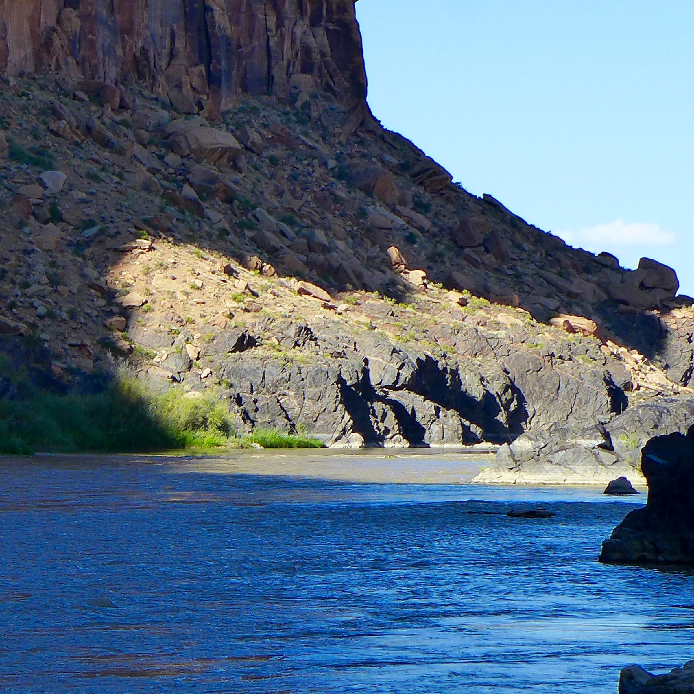
Split Mountain Gorge Green River June 2015 via Ana Ruiz
Updated with The Salt Lake Tribune story below.
FromThe Grand Junction Daily Sentinel (Dennis Webb):
Aaron Million has filed for a water right with the state of Utah for the project, which would involve diverting about 55,000 acre-feet of water a year from the Green River near the Browns Park area close to the Colorado line. The water would be piped east in Wyoming and then south into Colorado.
The project differs from a previous version Million proposed years ago in that it involves about a fifth as much water, and the previous incarnation would have diverted water upstream, from Flaming Gorge Reservoir.
Both the past and present versions have a hydropower element to them. The Federal Energy Regulatory Commission in 2012 denied a preliminary permit application for the pipeline proposal…
He’s doing so through the company Water Horse Resources LLC, which Million said has a new board and project team compared to the company that pursued the prior project…
Harris said there’s no evidence that Million has identified end users for the water, and speculation on water is illegal in Colorado, which raises the question of whether he’s trying to get a water right in Utah to sidestep Colorado water courts.
Million said he had subscribed interest in more than 400,000 acre-feet of water for the previous project…
Chris Treese, external affairs manager for the Colorado River District, said a Green River diversion to the Front Range would count against Colorado’s percentage of Upper Colorado River Basin water use under a 1948 compact with other Upper Basin states. Colorado already uses a higher percentage than it’s allocated under that compact, and if a water shortage kicks in under the basinwide 1922 compact and the Upper Basin has to deliver more water downstream, Colorado would have to contribute first to make up any deficit, Treese said.
He said there also are a lot of questions about what the route for the pipeline would be and whether anyone could use the water along the way.
“I think … right now the first step is trying to ascertain how serious (the proposal) is,” Treese said. “… It’s early in a process of looking at a long and complicated application.”
Million said the project’s estimated cost is $890 million to $1 billion, down from the $2.8 billion cost for the previous proposal.
He said a tripling in the cost of water on the Front Range has allowed for a much smaller project to be affordably built and still help some water-short areas.
He described the project as “a very simple plumbing project” that would be first and foremost about supplying renewable energy. He said it would include huge amounts of hydropower and pumped-storage hydropower. The latter involves pumping water at night when electricity is cheap into upper reservoirs and then sending the water through generators back to lower reservoirs to create higher-priced power during the day.
He said his company is looking at using a lot of solar and wind energy to power pump stations.
Million said that in bringing new water to the Front Range, the project would take pressure off some Front Range rivers, along with some Colorado River headwater streams now heavily taxed by diversions across the Continental Divide. That would boost water levels in the Colorado River mainstem, he said.
He also sees a benefit in tapping the Green River watershed in a year such as this one, when snowpack levels in that watershed are much higher than in the upper reaches of the Colorado River Basin.
He added, “All of the global warming models show the Green River system to be wetter than average in the future compared to the Colorado River mainstem.”
Million said moving the diversion point downstream of Flaming Gorge Reservoir addresses concerns that have been raised about impacts the project could have had on reservoir levels.
The proposal is a scaled-down version of Colorado resident Aaron Million’s controversial plan that the Federal Energy Regulatory Commission rejected in 2012. Under a new company name of Water Horse Resources LLC, the would-be water developer and Fort Collins-based entrepreneur filed the application Jan. 12, seeking permission to export 55,000 acre-feet of water, but with no specific use or destination offered.
His latest proposal, called Green River Pipeline or Flaming Gorge Project, would move 18 billion gallons a year — at a rate of 76 cubic feet per second — 375 miles across Wyoming, then south to Denver. Million estimates the project would cost $800 million to $1 billion, covered by private investors.
“We spent the last several years re-engineering the project and brought in a North American team and a new board of directors. Collectively they have $100 billion in net revenues,” said Million, who has also been working on his doctorate in natural-resource policy at Colorado State University.
His new vision of the project calls for powering the pipeline with wind and solar power, then recouping that energy with a series of inline hydro turbines on the downhill part of the line in Wyoming, taking advantage of the pipeline’s net elevation drop.
“At the end of the day, this is a renewable energy project,” Million said, noting the line would descend 3,800 vertical feet after cresting the Continental Divide. “That’s why we brought in the Canadians [SNC-Lavalin, headquartered in Montreal]. They are the world’s best in hydropower.”
He said the pipeline is being rebranded as Green River Sun Storage Hydropower Project, which will have a memorable acronym that resembles “grasshopper.”
The project began as Million’s master’s thesis. But from the beginning in 2006, his quest to tap the Green was ridiculed for its potentially astronomical costs, the lack of interest of water on the receiving end and subsequent denials from various permitting agencies…
“There is no indication that he is standing in the shoes of real users in Colorado, or Wyoming or anywhere,” said Rob Harris of Western Resource Advocates, a public-interest law firm that contested Million’s earlier proposals. “Water is a public resource in Utah and Colorado. As such, in both our states you need a real use to have standing to claim a water right like this.”
[…]
Now Million proposes drawing the water from two points in Utah’s Daggett County, several miles downstream from the dam and just upstream from Browns Park National Wildlife Refuge. The pipeline alignment still tracks along Interstate 80 across Wyoming but it drops south only as far as Denver…
Under Million’s application, the appropriated water would be used in a variety of ways, including municipal, industrial, commercial, irrigation, livestock and mining. It would move in a buried pipeline through inline hydroelectric turbines in Wyoming, which would allow the project to capture some of the power it would use to lift the water over the Continental Divide.
Nor does the application identify any specific destination. It is accompanied by a hand-drawn map showing the pipeline alignment and a Y-shaped “place of use” in northern Colorado outlined in red, covering 47 townships. Maps of these townships are also attached to the application…
Among the partners Water Horse lists on its web site is Central Colorado Water Conservancy District, based in Greeley, which provides augmentation water to around 600 farms in the South Platte River Valley. The district is under contract to provide 85,000 acre-feet, but its ability to meet these obligations has been “curtailed” by half, according to executive director Randy Ray…
Daggett County opposed Million’s pipeline project the last time around. County Commission chairman Jack Lytle said he was not familiar enough with the new proposal to provide comment on Monday.
Conservation groups oppose the diversion because of its potential impact on habitat for both sport fish and endangered native species, such as the Colorado pikeminnow, bonytail, humpback chub and razorback sucker.
The natives depend on occasional chaotic high flows that rearrange the stream channel, but have been widely depleted by dam operations…
“The river system is so overtaxed and these fish so overstressed, any more removal of water would jeopardize the existence of these four fish,” said Michael Saul of the Center for Biological Diversity. “Taking another 55,000 acre-feet out of the Green is a ridiculous idea in light of the fact that these fish are not recovering under the recovery plans now. This depletion is so huge, it is not covered by current biological opinions.”
For its part, Trout Unlimited has invested in programs that compensate water-rights holders for allowing more water to remain in the Colorado River system to support healthy fish habitat. A proposed diversion as big as the one Million is pursuing would defeat those efforts, according to Jordan Nielson, coordinator for Trout Unlimited’s Western Water and Habitat Program.
Most people know the Colorado River for its iconic landscapes, but it is also an incredibly hard-working river. It provides drinking water for more than 36 million people in the U.S. and Mexico. It irrigates over 5 million acres of agricultural land – supplying a majority of carrots, lettuce, and other vegetables in the winter to U.S. consumers. It provides hydropower and supports a $26 billion recreation economy. It is critically important for people but is also essential for wildlife in a region that is mostly desert. But all of this is at risk. Demands on the river exceed supply and the river has been stretched to the breaking point.
In the past, water users were often pitted against the environmental needs of the river and wildlife. To find a sustainable path forward, the Conservancy needed to find common interest with farmers, who control most of the water, and cities, who have most of the growth but also funding. This is taking shape on the ground through our efforts to develop a water bank in the Upper Colorado River Basin. At its basic level, the water bank would be a market based approach that would compensate water users to temporarily reduce their use in order to avoid regional shortages and provide certainty to water users while keeping more water in our rivers and streams.
In Western Colorado, the Conservancy has joined with farmers, municipalities and other partners to test a large-scale approach to this water bank concept.
In April, the Conservancy will launch a pilot project with the Grand Valley Water Users Association, the biggest irrigation provider in the valley. The project’s 10 participants will reduce irrigation on 1,250 acres, creating 3,200 acre-feet (about a billion gallons) of water savings that will improve river flows and provide system-wide benefits.
“The Grand Valley Water Users Association had the unique opportunity to participate in the creation of this Pilot Project coming to fruition in 2017,” said Mark Harris, the association’s General Manager. “The Association sees this endeavor as critical to our timely response to the ever increasing climatic, population, and political pressure on Colorado River water supplies.”
“We are very excited about this project,” said Aaron Derwingson, the Agricultural Coordinator for the Conservancy’s Colorado River Program. “Not only will it test the nuts and bolts of this approach, but it shows that working closely with agricultural producers and water managers to design the program is critical to its success.”
If successful, this project can be replicated and applied to other watersheds within the Colorado River Basin, to better ensure water security for our communities, farms and the environment.
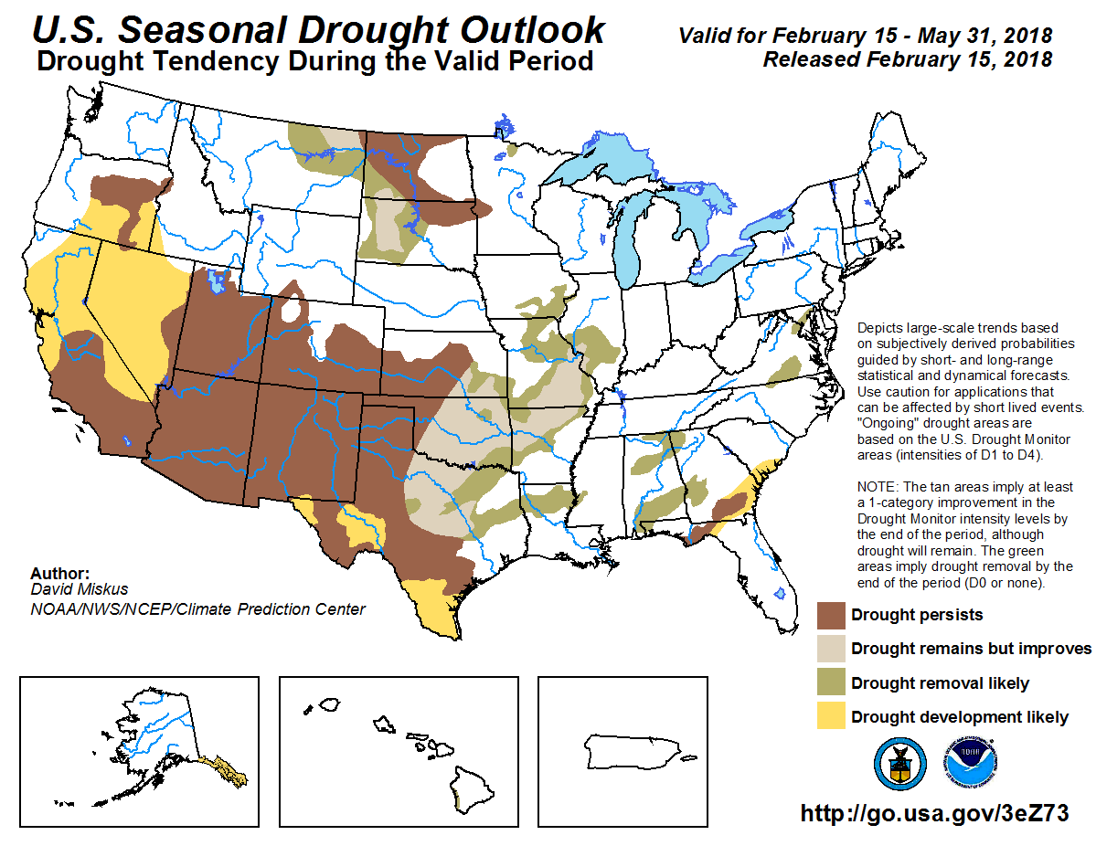
Three month temperature outlook through May 31, 2018 via the CPC.Three month precipitation outlook through May 31, 2018 via the CPC.Three month drought outlook through May 31, 2018 via the CPC.
What’s New
Since last month’s briefing, sea-surface temperature (SST) anomalies have cooled slightly in the area of the central equatorial Pacific Ocean that helps define El Niño and La Niña events, called the Nino3.4 region (see first map below). The average of these weekly anomalies for the last month was nearly -0.9ºC, which falls in the category of a weak, bordering moderate, La Niña state. For the previous month, the Nino3.4 anomaly was -0.7ºC.
Sub-surface ocean temperatures were on a warming trend, although that has now been somewhat tempered (see second figure below). These sub-surface conditions are often a preview of what’s to come at the surface, so it’s likely that La Niña conditions at the surface will diminish in the next couple of months.
Making a quick end to La Niña even more likely is a recently burst of westerly winds in the western Pacific, likely related to a Madden-Julian Oscillation event. La Niña is sustained in part by stronger-than-normal trade winds that blow from east to west, so these bursts of winds from the west can help break down a La Niña event. The wind event can be seen in the bottom left corner of the leftmost panel in the third image below. Barnston said what sets apart this wind event from another one a few months ago is the eastern extent of it — a few months ago the event was confined to the western Pacific.
Because IRI and the National Oceanic and Atmospheric Administration’s Climate Prediction Center predict that La Niña will continue for now, the ENSO alert level remains at a La Niña Advisory, which was initially issued in November.
ENSO Forecasts
To predict ENSO conditions, computers model the SSTs in the Nino3.4 region over the next several months. The plume graph below shows the outputs of these models, some of which use equations based on our physical understanding of the system (called dynamical models), and some of which use statistics, based on the long record of historical observations.
The average of the SST anomalies predicted by the models in this month’s forecast are similar to the predictions in last month’s forecast. The means of both the dynamical and statistical models show gradual warming, with both crossing into neutral ENSO territory by the March-May season. The dynamical models warm more quickly and eventually reach a mean anomaly of just over +0.5ºC in the October-December season. The statistical models’ mean anomaly only reaches about +0.2ºC, similar to last month’s prediction. This period at the end of the forecast, however, is past the spring predictability barrier and is highly uncertain.
Based on the model outputs, odds for La Niña conditions are only slightly above the odds for neutral ENSO in the the current February-April season, with both around 50%. Neutral conditions then take over as the most likely ENSO state through most of the northern hemisphere summer. By the August to October season, El Niño chances become (barely) the most likely, but, again, uncertainty is high.
The official probabilistic forecast issued by CPC and IRI in early February indicates similar overall trends in ENSO probabilities, but with less likelihood of El Niño in the later months. This early-February forecast uses human judgement in addition to model output, while the mid-month forecast relies solely on model output.
On Tuesday, Feb. 27, the town of Gypsum is hosting a water summit — an information session aimed at letting residents know what water restrictions could look like if the current weather pattern continues. At the town of Eagle and at Eagle River Water & Sanitation District, water regulations are an on-going effort to make sure everyone uses water wisely, restrictions are the next step if customers fail to do that.
According to Gypsum Town Manager Jeff Shroll, the most recent snowpack reading for the municipal watershed is at 30 percent of the 30-year average. While there is still time for that to turn around, he said the town wanted to begin discussions with residents about what a dry year means because many of them have never had that experience.
“We want to have the dialogue with our residents,” Shroll said. “The last time we had to look at water restrictions, our population was probably around 3,000 people.”
With Gypsum’s population now twice that amount, Shroll said residents need to be educated about drought condition watering restrictions, especially since the town recently revised those rules.
“We haven’t touched our water rates in years,” Shroll said, noting that depending on where they live, town residents see different rate structures. In older residential areas, domestic water is used for outdoor irrigation but in some of the new subdivisions — such as Buckhorn Valley and Chatfield Corners — nonpotable water is used for irrigation.
The town’s water ordinance calls out 15 different categories of residential and commercial users, both in town and out of town, but the base rate for Gypsum water service is $25 per month for a maximum of 20,000 gallons. As the town looks head to a possible dry year, Gypsum has instituted drought surcharges in their water rates. The surcharge will be 20 percent of the 1,000 gallon rate for users who exceed the maximum amount of water allowed for their categories.
As Gypsum communicates this new surcharge plan, Shroll said the town also wants to make sure residents are aware of the voluntary water use restrictions that are already in place:
Water lawns every other day and apply a maximum of 1 inch of water
Water lawns between the hours of 6 p.m. and 9 a.m.
Wash cars and equipment no more than once a week
Refrain from using water to clean off driveways, parking lots or streets
When the town imposes mandatory water restrictions, residents are required to abide by those rules and fines can be levied if they don’t.
As Gypsum lays out the rules it expects its residents to follow, Shroll said the town will also abide by the regulations.
“We are not going to ask our residents to conserve if we aren’t willing to do it as well,” he said. “Even with nonpotable irrigation systems at most of our town parks, we will be looking at cutting back our irrigation.
USE WATER WISELY
“Use water wisely” is the mantra at Eagle River Water & Sanitation District. That message is true in both wet years and dry years, but when the snowpack is below average, wise water usage is more important than ever.
“We are really connected to our water resources here and they are our water supply,” said Diane Johnson, communications and public affairs manager for Eagle River Water & Sanitation District. “What we are choosing to use is coming directly out of our water sources.”
Because people respect the recreational and aesthetic values that local creeks and rivers provide, Johnson noted that the conservation message is very tangible.
As the summer months approach, the district is tracking snowpack information, particularly at three sites monitored by the US. Department of Agriculture Natural Resources Conservation Service’s SNOWTEL report. Those sites are showing snowpack below the 30 year average, but Johnson noted it is still too early to predict a drought year.
“They (the SNOWTEL readings) are a snapshot of one location on one day,” she said. “But we are taking our preparations seriously.”
REGULATION, NOT RESTRICTION
The district has recent history to learn from as it looks ahead to a possible dry summer. In 2012, when stream flows in August were very low, the district reached out to a stakeholder group to share information and ask for a voluntary reduction in water use. That effort was successful and the district never had to move to water restrictions.
On that subject, Johnson said if water restrictions become necessary, users are not forewarned. Johnson noted if they have noticed that more restrictive restrictions are coming, then customers often increase the amount of water in anticipation. That behavior makes the imposition of restrictions counter-productive, especially when every day conservation is encouraged.
“We really want people to take conservation seriously and reduce the amount of water use,” Johnson said.
The town of Eagle and the Eagle River Water & Sanitation District’s water regulations mirror one another. They are:
No outdoor water use on Mondays
Odd numbered addresses can irrigate on Tuesdays, Thursdays and Saturdays
Even numbered addresses can irrigate on Wednesdays, Fridays and Sundays
Outdoor water use is allowed before 10 a.m. and after 4 p.m.
Eagle Public Works Director Bryon McGinnis noted that the current readings show snowpack at 85 percent of normal, saying that late winter and spring snowfall could still bring up the average. He echoed Johnson’s message that water regulations are always important for the town’s resources and urged people to voluntarily comply with the rules.
“We really want nobody to water on Mondays to get our tank filled up,” McGinnis said. “We will be asking people to conserve on their use and this year we will probably be more strict than in previous years.”
This year’s drought is caused by a dearth of snow, which supplies Colorado with most of its water. The continued rise in Colorado’s population doesn’t help.
A drought in winter is a bad sign of what’s to come for summer, as a winter drought could increase risks in summer as well as exacerbate wildfire risk, which the state already suffers enough from. Unless there is a very snowy late winter and spring or an abnormally rainy spring and summer, Colorado is in for drought of increasing severity until next year’s snowpack…
Fort Collins and northern Colorado are currently labeled as ‘abnormally dry’ while Denver and the surrounding areas are labeled as ‘moderate drought.’ Grand Junction and most of the Western Slope are labeled as ‘severe drought.’…
Fort Collins Utilities implemented a Water Efficiency Plan, and water use has declined nearly 40 percent since 2000. Fort Collins is on track to hit the previous mark for 2020, and is aiming for an increased decline before 2030. It is actually illegal to waste water in Fort Collins, and last year Fort Collins Utilities identified and addressed 55 cases of such waste taking place.
Everyday citizens can help be more water conscious by critically thinking about the water they use. It’s easy to leave the water running while doing dishes, but is it really necessary? No.
Similarly, while this rubs some people the wrong way, not flushing the toilet every time can help save water, because the toilet is the number one consumer of water in a residence. If not flushing isn’t something you’re comfortable with, consider putting a half-gallon to a gallon filled jug in your toilet tank – older toilet especially use a lot of water, and by creating displacement in the tank, the toilet will use less water.
While we don’t need to restrict showering to 90 seconds twice a week like Cape Town, shorter showers can help anyone, anywhere. Leaks also account for 12 percent of daily water consumption; many people may have a leak that isn’t causing problems, so they don’t do anything about it. It’s important to call your utilities or maintenance people when you find a leak, because that can be a significant source of water waste.
Small things like turning off the faucet while washing hands or brushing teeth can also help stop water waste. Reusing shower water or pasta water to water plants can, too.
Years like the one we’re in, where snow has been scarce reminds us all about the importance of water conservation. Snow pack in the Colorado Rockies acts as water storage and about eighty percent of Denver’s water comes from this mountain snow pack. Snow falling west of the continental that flows into the Colorado River feeds a demand, more than it can supply downstream. Years with a lack of snow in the mountains of Colorado (and other locations) can adversely impact recreation, agriculture, businesses, and residents who depend on the water from snow pack…
Snowpack levels across the Colorado Rockies are running well below average so far this year but there is still time for a comeback. There is a chance through the next couple of months for the La Nina phase of the El Niño–Southern Oscillation or ENSO to become neutral which could bring more moisture to the state through the spring.
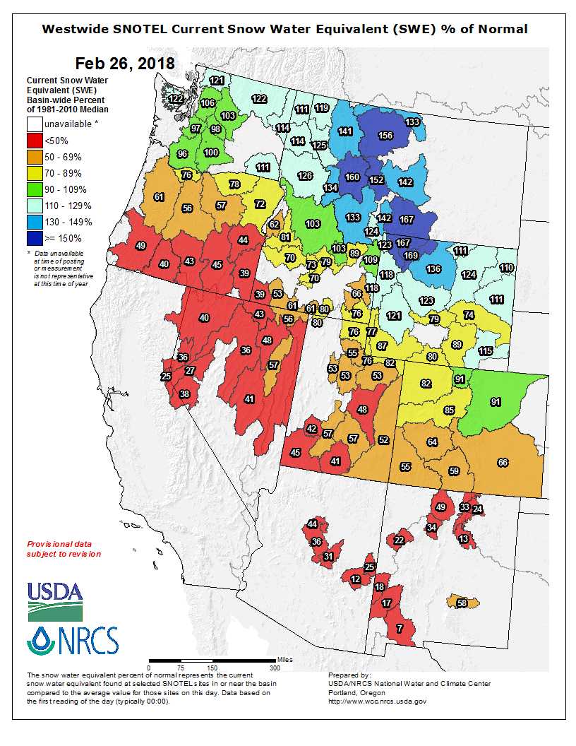
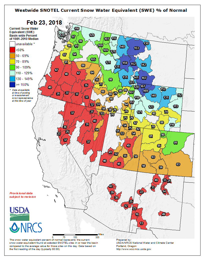
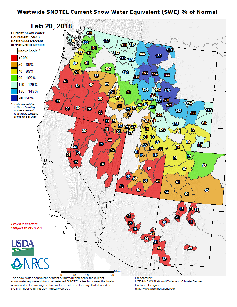
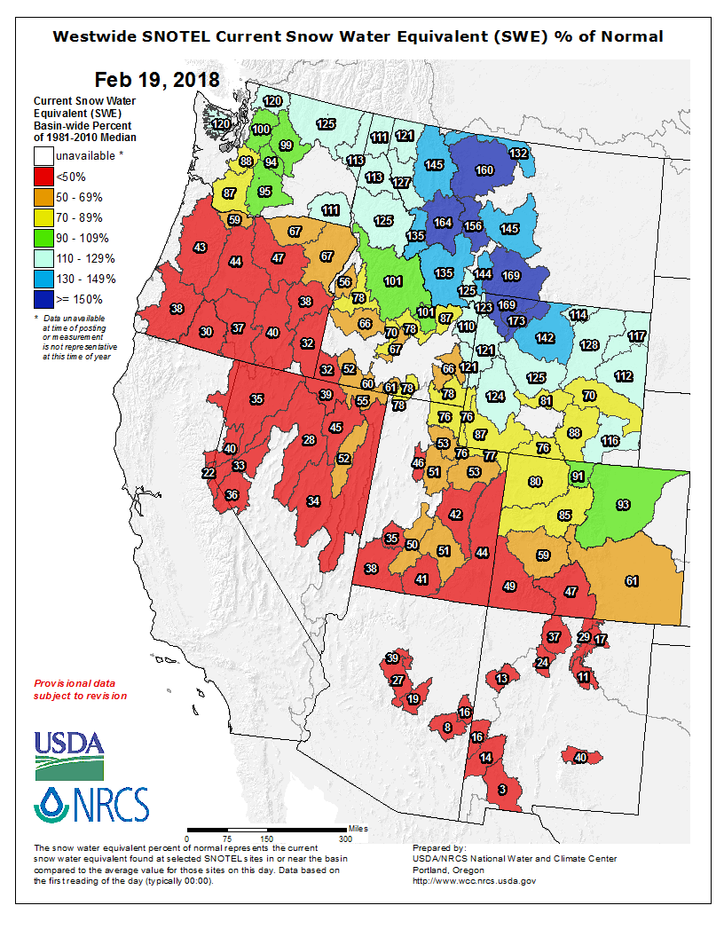
Here’s the Westwide SNOTEL basin-filled map for February 26, 2018 via the NRCS.
Westwide SNOTEL basin-filed map February 26, 2018 via the NRCS.
Gov. John Hickenlooper addressed the estimated 350 participants during the Wednesday event, touting his idea for how to fund the state water plan, NAFTA and other trade issues and what he sees as the next big opportunity for economic development in rural communities.
Hickenlooper has twice this month pushed for a statewide ballot measure to restructure the state’s severance tax collection system, a ballot measure that he indicated would come from the General Assembly. Colorado’s severance taxes are the lowest in the region, Hickenlooper told the audience, a situation worsened by a 2016 court decision that forced the state to refund millions of dollars to oil companies for property tax deductions disallowed by the state’s Department of Revenue. The court ruled in favor of oil giant BP in that case, and the state used severance tax revenues as well as other state dollars to pay those refunds.
State severance tax revenues are used to mitigate the impacts of oil and gas activity in rural communities, as well as pay for water projects. But the state has gone from about $150 million in those revenues two years ago to just $25 million last year, and that’s not enough. Hickenlooper hasn’t yet specified how he would want to see the severance tax structure changed. Currently, severance taxes are charged on the volume of oil and gas activity; one idea floated has been to charge something more like a flat tax, similar to how federal mineral lease revenues are collected.
State Sen. Jerry Sonnenberg of Sterling, however, dismissed the governor’s proposal during the ag forum. He said Colorado does not have the lowest severance taxes in the region, and he does not support restructuring the current system.
The forum’s most popular roundtable was on industrial hemp opportunities, which drew dozens interested in learning about the crop. According to one recent study, 19 states now allow hemp production, and Colorado leads the way in the total number of acres planted, at just under 10,000 acres. That represents more than a third of the total acreage in hemp production and half of the hemp produced nationwide. That might not seem like much, but the state only granted growers authority on the plant four years ago, after Congress authorized its production in the last farm bill.
Alex Seleznov is treasurer of the National Hemp Association and runs Pure Hemp Botanicals. He led the session on industrial hemp, cautioning those interested in getting their feet wet to do it slowly, at perhaps two to five acres.
It’s not the crop that will bail out grain growers, at least for now, although some of those who attended the session indicated they would look at hemp as a way of bolstering slumping farm revenues.
Hemp’s opportunities are nearly limitless, Seleznov explained. Its uses range from building materials, known as hempcrete; car parts, fuel and fiber.
Another hot issue at the ag forum: legal and undocumented immigration. A panel of experts on labor issues in agriculture talked about the problems farmers and ranchers face in finding workers in an economy with very low unemployment.
Americans don’t want to do the jobs offered by many farms and ranches, according to the panel, and that’s made many turn to legal immigration and to undocumented workers. But that system has its own share of headaches…
Jon Slutsky, who owns LaLuna Dairy near Fort Collins, started out as a novice in the dairy industry with 64 cows. He and his wife now have more than 1,500 and have gone from just the two of them to 30 employees.
Slutsky was part of a team that produced a white paper on the state of agriculture in Larimer County. The 18-page paper noted that farmers are started to move away from certain labor-intensive crops because they can’t find the labor to maintain and harvest it. Robert (RT) Sakata, who farms 1,600 acres of vegetables, one of the largest vegetable farms in the state, this month announced he would stop growing sweet corn because he could no longer afford the labor costs for that crop. He has also stopped growing broccoli and cauliflower, and told this reporter he would continue to grow onions and grain corn, including on those fields that formerly grew other vegetables. The problem hit him hardest when he looked at the auction brochure for his corn equipment. “I got a lump in my throat” when he looked at the brochure, he said.
Sakata Farms has produced sweet corn for 74 years.
Kelli Griffith is executive director of the Mountain Plains Agricultural Service, a trade association for sheep and cattle herders. “We’ve had to advocate for our members in more political arenas,” Griffith told the audience. That includes the H2A agricultural visa program, which requires those who seek workers to deal with four different federal agencies. The program’s deadlines don’t work well for agriculture, Griffith said, requiring farmers and ranchers to estimate their workforce needs well in advance of growing and harvest season. Such a system leaves no room for changes, whether from drought or other situations, she explained.
The association is looking for relief with the H2A program, Griffith said. The minimum wage requirement for H2A can be higher than the federal minimum wage, because it’s based on the minimum wage in the state where the worker is headed. If it’s a foreign applicant, the farmer or rancher pays for the cost of the visa, travel, food and housing, she said, which allows herders to send home their entire paycheck since they have no living costs. She also noted that while the minimum wage for herders has doubled in the last three years, the number of applicants for those visas has actually dropped. The Larimer County report noted that the current US immigration system provides less than four percent of the workers needed in agriculture.
H2A also requires the employer to attest to the need, requiring proof that no American wants that job. If the labor need changes, the employer has to commit to paying the worker at least three-quarters of the contract, regardless of how early it ends.
The solution, at least to some, is automation. “It can’t happen fast enough,” Sakata told this reporter.
The ag forum is led by the Colorado Agricultural Leadership Program; Sonnenberg, a graduate of the program, is the board chair.
A high desert thunderstorm lights up the sky behind Glen Canyon Dam — Photo USBR
Here’s a in-depth look at the history of Glen Canyon Dam from Reuben Wadsworth writing for the St. George News. Click through and read the whole article and check out the impressive gallery of photos. Here’s an excerpt:
To those who opposed the dam, Glen Canyon’s history reads like an obituary about the loss of an incomparable sandstone and water wonderland boasting a plethora of Native American ruins, emerald hanging gardens and a few spectacular natural bridges – a place to truly commune with nature and to find complete solitude since few made the effort to traverse the river along the canyon’s stretch.
Those on the other side of the issue feel the dam has improved Glen Canyon – now providing greater access to its breathtaking contrast of towering crimson sandstone walls and vast expanses of crystal blue water.
No matter what side one is on, the history of the grand red rock spectacle in Southern Utah and northern Arizona is a compelling one.
Near Flagstaff, I pulled into a service station and parked next to a Subaru with the words “We Survived Hurricane Harvey, Orange, Texas” scrawled on the back window in bright-pink letters. The mud-splattered car was loaded with luggage, boxes and a guitar case. A middle-aged woman and a scruffy man with wild brown hair pulled themselves out, looking road-weary and haggard. The man popped open the hood and fiddled with some wiring.
I nodded to the words on their back window. “How bad was Harvey?”
“Bad,” the woman said. She introduced herself as Melanie Elliott. “We had to get out of there.”
“It was a fucking disaster,” the man said, bent under the hood. His name was Andrew McGowan. “We got swamped.”
Orange, I later learned, is an old industrial seaport near the Louisiana border, population 18,643. The town has been hit repeatedly by recent hurricanes: In 2005, Rita savaged the city; three years later, Ike breached the city’s levee and flooded the streets with as much as 15 feet of water. Three people died. “We were just dealing with water all the time, constant flooding,” McGowan continued. “The whole place is going under.”
“Harvey was it for us,” Elliott added. “Too much water, we can’t deal with this anymore. We are going to San Diego.”
“What are you going to do there?” I asked.
“We don’t know,” McGowan said. “I’m gonna play some guitar and see what comes along.”
As they piled back into their Subaru and headed toward the highway, I thought of the old Woody Guthrie song about the farmers fleeing the Dust Bowl: “We loaded our jalopies and piled our families in/We rattled down that highway to never come back again.”
From the West Greeley Conservation District (Rona Johnson) via The Greeley Tribune:
The West Greeley Conservation District will conduct its first Northeast Colorado Progressive Ag Symposium on March 14-15 at Island Grove Park, 501 N. 14th Ave. in Greeley. The symposium is free but the conservation district requires attendees to RSVP by March 6 so they can get a head count for lunch.
The first day of the symposium will focus on soil, including topics such as soil health and no-till practices. The second day will feature water and include presentations that address irrigation methods and conservation, among other topics.
Kandee Nourse, district manager for the West Greeley Conservation District, said they would like to do something similar to this event every year, depending on the popularity of this inaugural symposium, which includes speakers from other states who may have some new ideas or technologies that might be of interest in this area.
The keynote presenter, David Montgomery, a MacArthur Fellow and professor of geomorphology at the University of Washington, is an internationally recognized geologist who studies landscape evolution and the effects of geological processes on ecological systems and human societies.
» John Stulp, the special policy adviser to the governor for water and interbasin compact committee director, is charged with bringing together a mixture of ideas and pathways for a water plan that balances Colorado’s future water needs.
» Dan Rudnick, an assistant professor of biological systems engineering at the University of Nebraska-Lincoln, will present information about irrigation management.
» Gregory Scott, a certified professional soil scientist, will address soil health principles and the history of the soil health movement.
Symposium attendees also will hear weather analysis from Russ Schumacher, an associate professor in the Department of Atmospheric Science at Colorado State University and editor of the journal, “Monthly Weather Review.”
» Rick Bieber will use his farm and soils as an example of how everyone can feel good about soil care.
» Jason Von Lembke, vice president of land and resource management from The Bromley Companies, is the project manager for the Subsurface Irrigation Efficiency Project, a 165-acre research farm in Kersey, where they collaborate with Colorado State University to study subsurface drip irrigation, water efficiencies and conservation, crop/water coefficients and collaboration between agriculture and oil and gas interests.
Organizers are still working to secure speakers for the event.
The event also will include booths, but the “people who are coming aren’t selling anything, they will teach people about getting soil moisture from plants and not necessarily the soil itself, for example,” Nourse said.
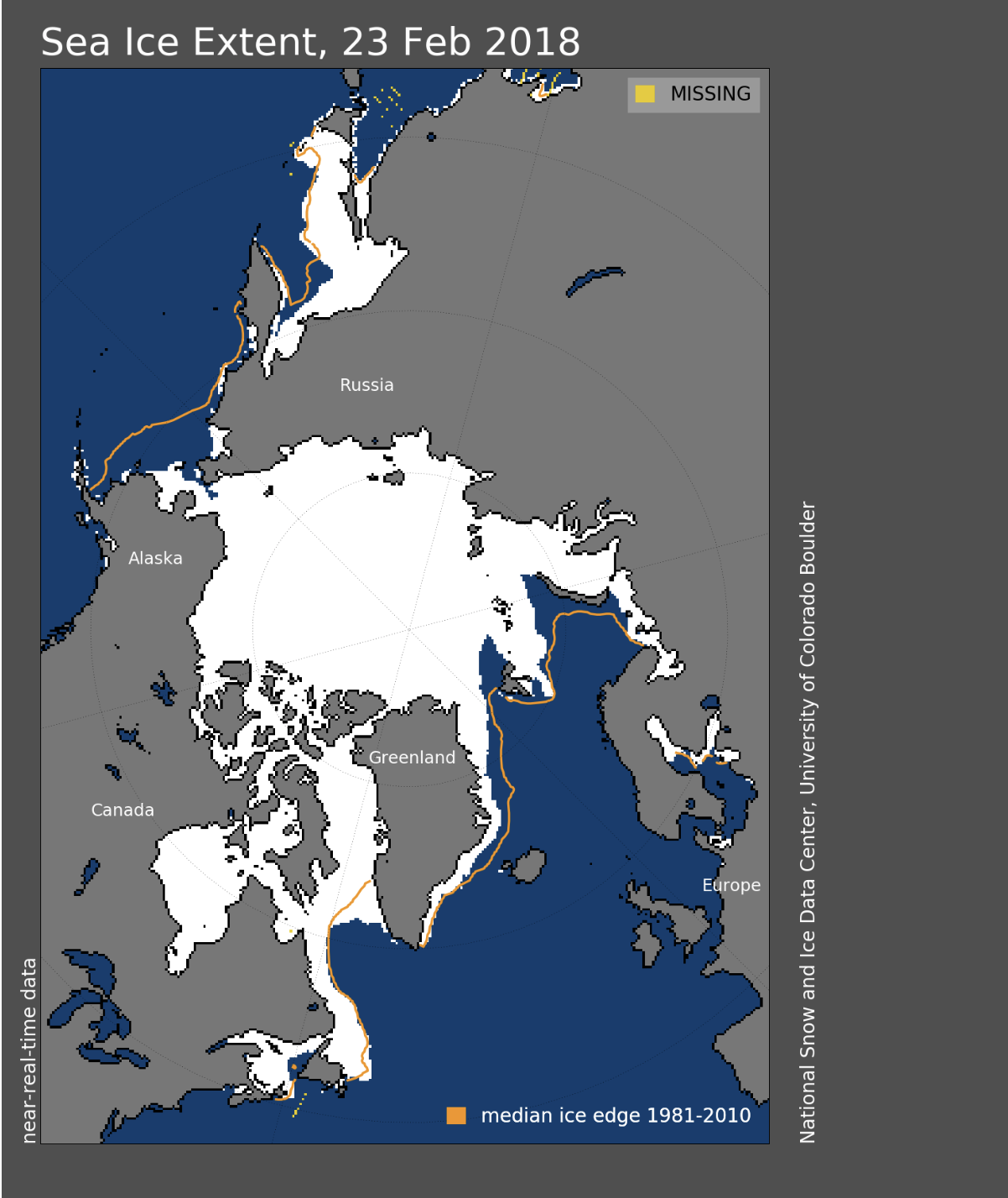
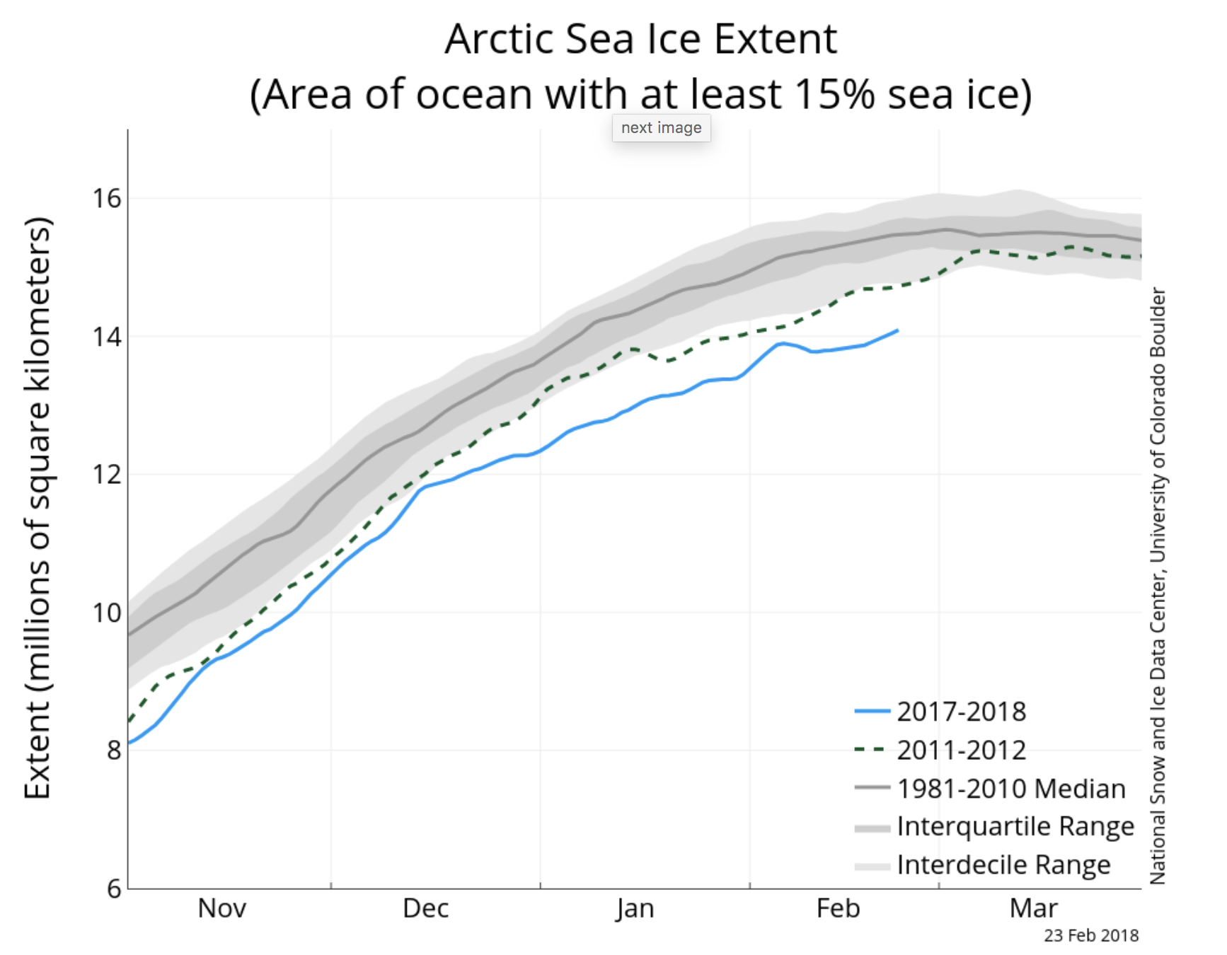
The Bering Sea has lost roughly half its sea ice over the past two weeks and has more open water than ever measured at this time of year.
“This is unprecedented,” said Brain Brettschneider, a climate researcher at the University of Alaska Fairbanks. “The amount of ice is less than it’s ever been during the satellite era on any date between mid-January and early May.”
Graphic credit the National Snow and Ice Data Center.
“Water was so important they put it in our Constitution, how water is to be divided in Colorado, and it works — still to this day — very well,” Yahn said, explaining that the way it works is the first people who go out and get the water and start using it are the first to have the right to use it.
Water rights are decreed in water court; for the South Platte River the water court is located in Greeley, and once they’re decreed the water rights can’t be changed, even by the legislature.
After ditch companies came and started pulling water off the river and irrigating with it there wasn’t enough water in the summertime in this area, but there was in the wintertime, so farmers grouped together and the legislature passed the Irrigation District Law of 1905.
“They made it so farmers could get into bigger groups and get bonding and things like that, so that they could pay for bigger systems,” Yahn said, explaining that’s what he manages: Prewitt Reservoir, which is 32,164 acre-feet, was built from 1910-1912, has a 30,000 acre service area, and has 250 owners, and North Sterling Reservoir, which is 74,590 acre-feet, was built from 1909-1911, has a 41,000 acre service area and has about 140 owners.
Water rights development in South Platte Basin was influenced by return flows.
“Way back when, you had not only fights within the state between farmers and miners and other farmers, but you also had other states that depended on that river,” Yahn said.
The South Platte compact was negotiated by Delph Carpenter and signed by Colorado and Nebraska in 1923. In a letter from Carpenter to the governor, he said the flow was excessive in May and June and disappeared entirely during the summer; the river frequently became dry for months of each year, to points as far west as the present city of Fort Morgan. He said the flow of return seepage waters coming back to the river from irrigation in Colorado lands had resulted in a constant supply at the interstate line.
“So, he wasn’t too concerned with this agreement that we were making with Nebraska to supply them water, because he said this flow was increasing and he said it soon will be efficient to take care of the full demands of both us and Nebraska,” Yahn said.
Ralph Parshall conducted a study in 1922 on the “Return of Seepage Water to Lower South Platte.” His findings included that return flows were increasing over time and continued to increase mostly due to the general rise of the water table. He said in some areas the water table would rise each year as much as 100 feet and noted the flow increases along the river from 2 to 8 ½ second feet per mile. He also said diversions from the river after spring floods had subsided were practically all from seepage water.
“So, he’s saying after the snowmelt heads out, there’s really no source of water except for these return flows that come back to the river,” Yahn said.
From 1930s to the 1970s, America got rural electrification and people realized there was groundwater under the ground, so they began drilling wells. In the 1950s and 1960s there were droughts, so farmers were looking for other sources of water and really went after wells along the South Platte River.
In 1956, Parshall told the Rotary Club there were several issues impacting the dwindling river. While past records had indicated a steady increase in return flow to the river, in 1956 it was found that the seepage return was practically nothing and Parshall said that was partly due to the fact that between Kersey and Julesburg more than 4,000 irrigation wells pumped to deliver enough water to fill Horsetooth Reservoir four times during the 1955 season, twice as much water as it would take to fill all the reservoirs in this area — North Sterling, Prewitt, Jackson, Empire, Riverside and Julesburg.
Parshall also said it appeared obvious that we couldn’t continue depleting the groundwater at that rate. From 1954 to 1956, North Sterling Reservoir either never filled or was just a little over half full. Records show a similar pattern in the 1960s.
“You can probably feel the tension already; you have these guys with reservoir water with a 1910 water right and you have wells that were drilled in 1950, pumping away and growing crops while these guys sit here with nothing, fields blowing…” Yahn said.
He spoke about how the river is administrated, using an example with the Springdale Ditch (1886 water right), Sterling No. 1 Ditch (1873 water right) and Harmony No. 1 Ditch (1895 water right).
“What happens is you have these ditches that seep and all this water … seepage from the ditch, people call it wastewater, it actually goes back to the river and somebody else down river uses it,” Yahn said. “So, the interesting thing is even though Springdale has an 1886 water right, if Sterling No. 1 doesn’t have all their water, they call up the river commission and say ‘hey, we don’t have our water, you need to bring it us.’ The river commissioner will call up Springdale and say ‘you need to shut off; Sterling No. 1 doesn’t have enough water.’ It’s a pecking order,” Yahn said.
In the 1950s, wells were put in and intercepted water that was going back to the river. All the sudden it became evident in the reservoir system that they didn’t get any water. So, Colorado made a way that you can replenish this well pumping if you put in some recharge ponds.
“It’s a good way to allow people to pump their well, but still not injure senior water rights,” Yahn said.
In 2002, which was a dry year, not all the wells were replacing very much and the return flows back to the river per mile from Kersey to Julesburg was around four CFS for every mile. In 2012, after wells were required to replace their water, the line jumped back to what Parshall said, showing that the return flows were finally back to what they used to be.
Water is going to become an even more precious resource in the coming years, as the population in the South Platte Basin is expected to increase from 2.5 million to 6 million by 2050, and new water demand will increase from 359,000 to 525,000 acre-feet.
“We have to deal with that with water and what we’re trying to work towards is ideas that keep people farming, because if you’ve ever gone down into the Arkansas Valley, in Rocky Ford or anywhere in southeast Colorado, where Aurora went down applied for the water, took it out, it just devastates the community. So, we’re trying to come up with alternative ways to keep farmers farming, try and get water for municipalities and work together so that we can do that,” Yahn said.
There are projects that are being worked, but even if all the projects are built there will still be a shortage of 99,000 acre-feet, which is about 1.5 North Sterling Reservoirs, and if just 62 percent of the projects are completed there will be a shortage of 362,500 acre-feet, which is about five North Sterling Reservoirs.
Low snowpack in Southwest Colorado could affect spring runoff and the local economy if levels do not rise.
The Southwest corner of the state’s snow water equivalent is 54 percent of normal, according to recent data from the Natural Resources Conservation Service.
Snow water equivalent measures how much water is in the snowpack and is the standard for keeping track of snowpack, John Andrew Gleason, lecturer of geosciences at Fort Lewis College, said.
A potential downside of the snow water equivalent measurement is that it uses a 30-year moving average, Gleason said. As the years get drier, what is considered normal is drier too.
The Snowpack
The snowpack for 2018 is very low, Gleason said. Currently, the snowpack is lower than in 2002, the driest year on record in southwest Colorado and when the Missionary Ridge Fire happened.
The snow year is already halfway over, Gleason said. However, March and April is when this region generally gets the most snowfall, he said.
“The best thing that could happen is that it’ll snow,” he said
A heavy, wet snow is the best type of snow for the snowpack because it compacts and contains lots of water, he said.
A low snowpack and warm spring can lead to problems during the rest of the year. A colder spring is ideal so that the snow doesn’t melt off too fast, Gleason said.
Warm spring weather has been occurring earlier in the year, Julie Korb, a professor of biology at FLC, said. This dries out vegetation and leads to dangerous wildland fire conditions in the summer and fall, she said.
“In 2002, one of the reasons we had such a bad fire season here was the low snowpack and very little runoff,” Gleason said.
Dust, which decreases the reflectivity of snow, increases the rate of snowmelt in the spring, Gleason said.
As the snow melts and uncovers more exposed ground, there is more potential for wind picking up and carrying dust onto the snow, Gleason said.
Another possible problem is water supply. Reservoirs are currently close to normal, but water managers will drain the reservoirs in preparation for spring run off, Gleason said. It could be a problem if the runoff doesn’t fill the reservoirs back up, he said.
Low snowpack also increases avalanche danger because the snowpack is unstable. This was seen in the January avalanche death of a FLC alumnus, Gleason said.
La Niña
Low snowpack this year can be attributed to the La Niña weather pattern. La Niña years happen when water is cooler in the Pacific Ocean, which sends storms more north of Southwest Colorado, Gleason said.
La Niña years are normal or drier than normal for the Durango area, Gleason said. We are also in the second La Niña year in a row, and the second year tends to be drier, he said.
The perfect storm for this area is a low-pressure storm that sits above us rather than moving east too quickly, Gleason said.
“If you see rains in Los Angeles, and the winds are out of the southwest, that usually will predict a pretty big storm for us,” he said.
Local Economy
The Animas River could see lower flows, impacting rafting and water sport tourism in the summer, Tim Walsworth, Business Improvement District executive director, said.
It is hard to keep track of economic effects of warm winters in real time, Walsworth said. The best indicator of downtown patronage is sales tax, which isn’t immediately available.
Current sales tax figure are only available from last November, he said.
Winter is already a slower time of the year for Durango, Walsworth said.
January and February are usually the slowest tourism months in downtown, Theresa Blake Graven, public relations consultant at the Durango Area Tourism Office, said.
“We’re in a bit of a different situation here in Durango because we’re not like Crested Butte that’s completely dependent on skier tourism,” Graven said. “We have a lot of other stuff going on,” Graven said.
Polar express train bookings were up 10 percent over last year, Christian Robbins, marketing manager at the Durango and Silverton Narrow Gauge Railroad said.
The railroad estimates that 70 percent of the 33,000 passengers come from outside of the area, which leads to money being spent in Durango from lodging and other hospitality, Robbins said.
Downtown Durango’s peak activity occurs in July, and the second-best month is in December, Walsworth said. The winter festival Snowdown can bring needed business to town at the beginning of February, he said.
Snowdown was originally created to bring more more business into town during the slow winter months, Graven said. However, Snowdown tends to bring a more local crowd rather than people from out of town, she said.
[February 20, 2018] A western shift of a high-pressure ridge over the Pacific Ocean is allowing more storms to reach Southwest Colorado, according to the National Weather Service.
The ridge has been blocking winter snowstorms from the northwest from reaching Colorado, but two weeks ago, it moved out of the way, said meteorologist Megan Stackhouse, with the weather service office in Grand Junction…
On Tuesday morning, towns across southwest Colorado woke up to a fresh blanket of snow from Monday’s storm. Dolores registered 4 inches, Cortez had 2 inches, Mancos had 2.7 inches, and Farmington got 1 inch.
Ski areas are celebrating. The Hesperus ski area received 6 inches of fresh powder. In the past 24 hours, 9 inches of snow dumped onto to Telluride, which has seen 2 feet of new snow in the past seven days. Purgatory reported 10 inches yesterday’s storm, with a total of 33 inches of new snow in the past seven days.
Snowpack for the Dolores Basin is gaining ground because of the recent storms, and reached 50 percent of average as of Feb. 20. That is up from 40 percent of average on Feb. 12.
FromColorado Politics (Marianne Goodland) via The Durango Herald:
Hickenlooper, speaking to an audience at the 27th annual Governor’s Forum on Agriculture this week, said that the Colorado Outdoor Recreation Industry Office met with representatives from recreation offices and outdoor recreation companies from eight states, and the result was something called the Colorado Accord. It’s a nonpartisan effort to work on issues related to clean air, water and public land – areas the trade association strongly supports and part of the reason the trade show moved to Colorado, he said.
This accord is the start of an opportunity for Colorado to be a national leader in outdoor recreation, Hickenlooper said. The companies involved are small – around 10 to 15 employees.
“They don’t want to live in the cities or their businesses to be in the cities,” he said. “These are companies that are naturals for smaller communities … . This is a chance to build a relationship between farms and ranches and outdoor recreation. If you want more jobs in your towns, there will never be a better chance.”
The governor also addressed the ongoing negotiations over the North American Free Trade Agreement, and the importance of maintaining partnerships with Canada and Mexico, which are NAFTA partners. The renegotiation of the 22-year old agreement hasn’t gone as quickly as he would like, Hickenlooper said.
“Our relationships with Canada and Mexico need to remain strong,” given that more than half of Colorado agricultural exports go to those two countries, he said, adding that NAFTA has the potential to do so many good things for Colorado, and that he has talked with officials from both countries.
“They just want a deal,” Hickenlooper said.
Hickenlooper said he recently spoke with the U.S. Secretary of Agriculture Sonny Perdue and their positions align on several issues, such as the need for better and faster negotiations with South Korea, China and India on agricultural trade; about volatility in the labor market for ag, and for a more balanced approach on agricultural regulations.
One of the state’s highest priorities for global exports, he said, is to open up Asia. “There’s an insatiable appetite for beef and pork” in South Korea, China and Japan, and the U.S. needs a fair deal with those countries.
Hickenlooper also made a push for a long-term funding solution for the Colorado water plan. Last month, the governor said he favored a change in how the state collects severance taxes on oil and gas, saying, among other things, that Colorado has the lowest severance taxes on oil and gas in the region.
A court case two years ago with oil giant BP dramatically reduced the amount of severance taxes the state can collect, which has been used in the past to mitigate oil and gas activities in rural communities and to pay for water projects around the state. The state had to take money out of its general fund to pay for the property tax deductions the court decided BP was owed. After that, the state’s share of severance taxes dropped from around $150 to $200 million per year in 2016 to about $25 million last year, Hickenlooper said.
Without a structural change in how severance taxes are levied, he warned, severance taxes could come to an end. “But let’s get a referred measure on the ballot” that will provide a fair tax structure for oil and gas, he said. “It’s a social contract with the state of Colorado. If it were presented properly,” voters would not walk away from it.
That didn’t fly with Senate President Pro tem Jerry Sonnenberg of Sterling, who was in the audience and is president of the board of the Colorado Agricultural Leadership Program, which hosts the annual agriculture forum. Sonnenberg disputed the governor’s claim that Colorado has the lowest severance taxes in the region.
Sonnenberg told Colorado Politics that “we have robbed $400 million from severance taxes” to cover budget shortfalls, including $100 million to pay BP for the lawsuit. “We need to figure out how not to rob Peter to pay Paul,” Sonnenberg added. “If we truly want to do something about severance tax, maybe we add all energy: wind, solar, nuclear and hydroelectric.”
North Fork Republican River via the National Science Foundation.
From the Associated Press (Grant Schulte) via The Colorado Springs Gazette:
The settlement announced Thursday requires Colorado to make the payment by Dec. 31, 2018. Colorado officials did not admit to violating the Republican River Compact, and legislators in that state must still approve the funding.
The agreement seeks to resolve disagreements between the states over Colorado’s past use of water. The Nebraska governor’s office says it will allow both states to continue to work cooperatively.
The settlement bars Nebraska from suing Colorado for alleged violations on or before Dec. 31, 2013.
It was signed by Nebraska Gov. Pete Ricketts and Attorney General Doug Peterson as well as Colorado Gov. John Hickenlooper and Attorney General Cynthia Coffman.
The Republican River’s South Fork near Hale, Colorado, with the region’s seemingly endless fields. Credit: Wikimedia Commons/Jeffrey Beall
Subject to approval by the two states’ legislatures, the payment is due by Dec. 31, with the money earmarked for surface water projects that will bolster water management plans in the basin, Colorado Attorney General Cynthia Coffman said in a statement.
“This settlement provides funds that could be used in the Republican River Basin within Nebraska and creates additional opportunities for cooperative water management between the states,” Colorado Governor John Hickenlooper said.
Nebraska Governor Pete Ricketts echoed the sentiment of cooperation: “Nebraska and Colorado can now continue to focus on providing their water users with greater certainty and to pursue other collaborative opportunities to benefit their shared economies.”
The 452-mile-long Republican River originates in the high plains of Colorado and cuts across sections of western Nebraska and Kansas. The Republican River Compact of 1943 allocates river water for the three states, with 49 percent going to Nebraska, 40 percent to Kansas and 11 percent to Colorado.
The river basin has been a frequent subject of litigation, including a 2014 Supreme Court judgment that ordered Nebraska to pay $5.5 million to Kansas for its own excessive water use upriver.
Colorado officials said the threat of more litigation and its associated costs was a driver in the new settlement. Coffman said the agreement “avoids the costs and uncertainty of litigation and furthers the principles of the compact.”
The region has been relatively free of major drought in recent years, which has helped states stay in compliance despite exponential growth in the number of irrigation wells. According to the United States Drought Monitor, the Republican River Basin region is drought-free or abnormally dry, the least severe drought rating.
But the threat of drought and overuse of groundwater has kept agriculture officials and farmers on edge for years. Nebraska farmers have been suing the state over groundwater for years, in what has become a near-annual tradition.
Steve Nelson, the president of Nebraska Farm Bureau, welcomed the new agreement.
“We applaud the collaborative efforts of both states to address past issues and to work together, putting both parties’ interests on a better path for shared water use,” Nelson said.
Western water law, immensely complicated by decades of litigation in multistate jurisdictions, is further complicated by “use it or lose it” allocations that often discourage conservation.
The Republican River Water Conservation District’s “compact compliance pipeline” continues to pump ground water into the North Fork of the Republican River near the Colorado/Nebraska state line.
The pipeline first started operating for compact compliance in January 2014. It is part of Colorado’s effort to come into compliance with the Republican River Compact, a 1942 agreement among the states of Colorado, Nebraska and Kansas, concerning water rights along the Republican River.
A stipulated agreement among the three states requires Colorado to send a minimum of 4,000 acre-feet through the pipeline each year. The Republican River Compact Administration groundwater model approved by the three states is used each year to analyze and determine how much more water above the minimum needs to be delivered each year.
Approximately 11,000 acre-feet was delivered into the North Fork in 2017.
The final portion for 2017 was delivered from October through December after the irrigation season was completed.
The pipeline continues to operate as Colorado delivers the 4,000 acre-feet minimum prior to the upcoming growing season.
RRWCD General Manager Deb Daniel said the estimate of how much above the minimum will need to be delivered in 2018 will not be made until September.
Various factors figure into how many acre feet need to be delivered each year — such as the amount of groundwater pumping throughout the Republican River Basin with the amount of precipitation and where it falls within the basin. The more rainfall in Colorado’s portion of the basin can actually increase the state’s obligation to the downstream states.
Daniel noted the state has not had any problems meeting its obligations using the pipeline. Water for the pipeline comes from a series of wells located north of Laird that were purchased by the RRWCD as part of the pipeline project.The appropriation for all of the water rights has been designated to 15 wells within the pipeline project. Currently eight wells are connected and delivering water into the pipeline. In the near future, as the need to off-set depletions and deliver additional water increases, the remaining seven wells will be added to the pipeline system.
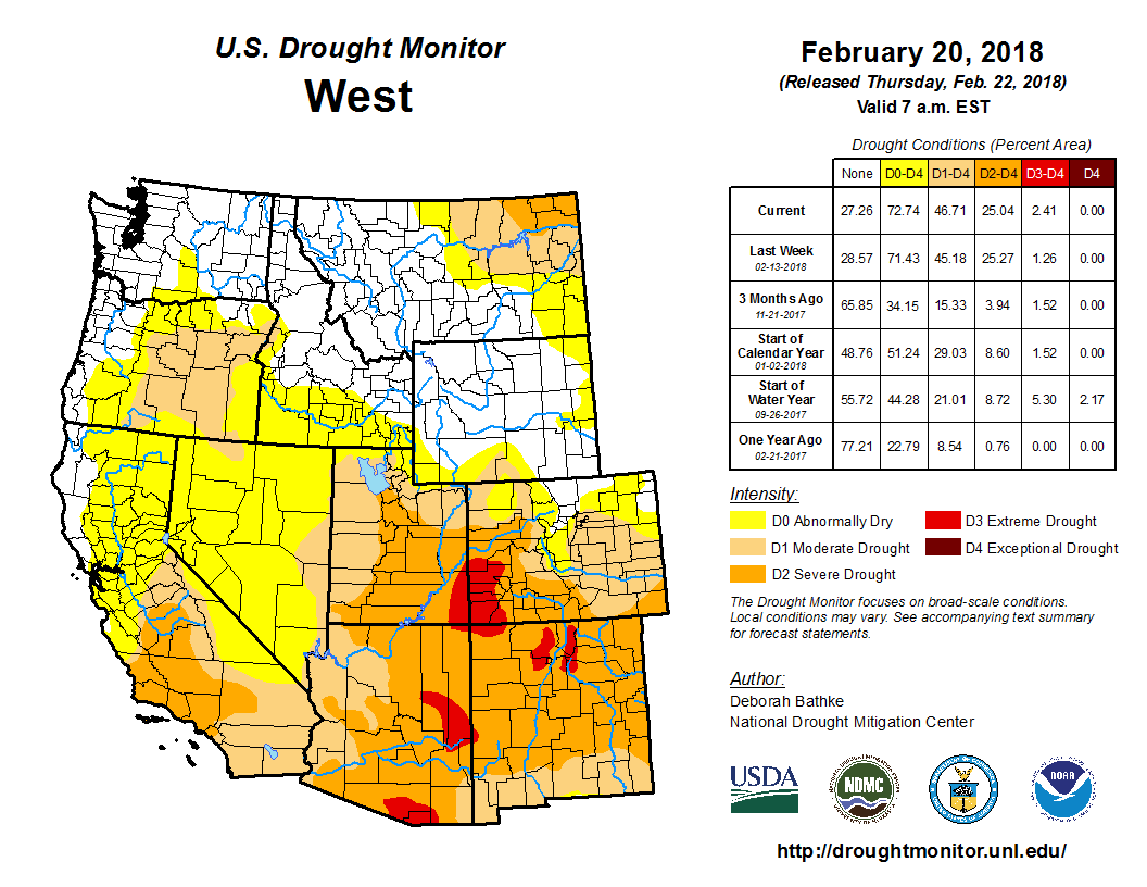
Click here to go to the US Drought Monitor website. Here’s an excerpt:
Summary
During the past week, large precipitation events affected the Pacific Northwest, Southwest, southern Plains, Midwest, Ohio Valley, Tennessee River Valley, and mid-Atlantic, alleviating drought conditions or preventing further degradations in these areas. An active storm track in the coming week is expected to bring additional precipitation in the central and southern United States, which may result in further drought reductions. Conditions degraded in some areas of the Desert Southwest and Intermountain West that missed out on the heavier precipitation, most notably the Sierra Nevada and the Four Corners…
High Plains
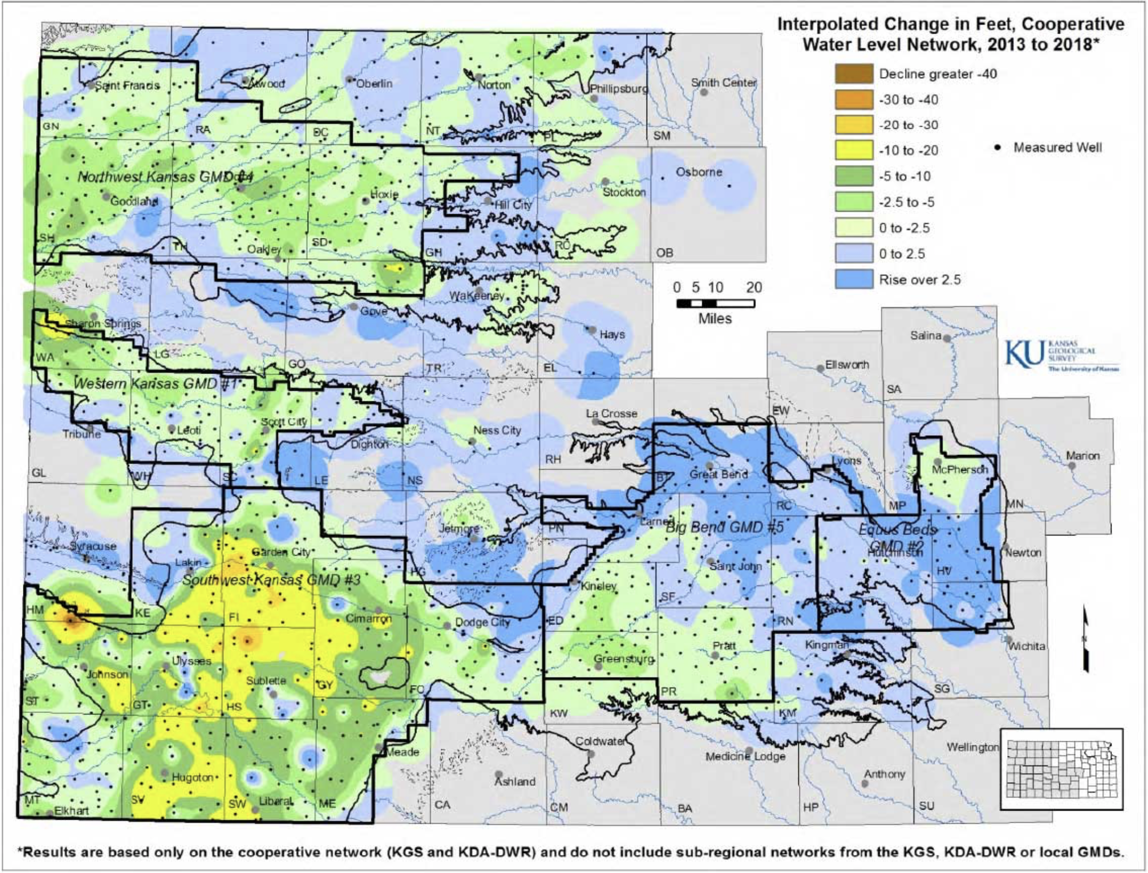
Several areas of precipitation fell in Wyoming (ranging from .25 inch to localized 2+ inches); the heaviest precipitation areas were in the Yellowstone/Teton high country and in the Snowy Range. No changes were made in Wyoming, as the snow in the Snowy Range prevented further degradation there. Precipitation between .50 inch and 1 inch took place in the Dakotas, so no changes were made here, except for an expansion of abnormal dryness along the US 14 corridor in east-central South Dakota where seasonal precipitation deficits persisted. Rains from the aforementioned Midwest storm systems clipped southeast and parts of south-central Kansas with .25 inch to 1.5 inches of precipitation. A small area of .25-.50 inch of precipitation also fell in northwest Kansas. Moderate drought expanded into northeast Kansas because of persistent short- to medium-term seasonal precipitation deficits and abnormally warm temperatures in the last month…
West
A storm system moving through the southwest United States led to moderate or heavy precipitation in parts of New Mexico, Arizona, Utah, and Colorado, with the heaviest Colorado precipitation taking place in the San Juan Mountains. Abnormally dry conditions in south-central New Mexico improved. However, the heavier precipitation missed the Four Corners region, worsening the long-term precipitation deficits. Most of California and Nevada also remained dry this week. Above-normal temperatures over the last few months, combined with precipitation deficits over most of the Southwest, led to the continuation of drought in much of the Southwest region. Moderate drought expanded through parts of the Sierra Nevada, where very low snowfall, short- and seasonal-range precipitation deficits, and warm temperatures so far this winter continued. Some ski areas have even closed because of the lack of snowfall. Abnormally dry conditions expanded through the rest of the Central Valley in California, where precipitation deficits over the water year and streamflow continued to degrade. Moderate drought expanded over south-central Oregon, where short-term and water year precipitation deficits intensified…
Looking Ahead
An active stormy pattern looks to continue in the central and eastern United States as we progress into next week. As a front continues to settle over the central, south-central, and eastern United States, expect moderate to heavy precipitation to continue in these areas late this week. A new storm system this weekend may deliver some rain and snow to parts of the central Plains, Midwest, Great Lakes, and mid-South. Mainly dry conditions are forecasted to persist in Florida, the Carolinas, and most of the low elevation areas of Nevada and California. Some precipitation approaching an inch is possible in the Sierra Nevada. Generally, temperatures in the western United States should fall below normal, while temperatures in the eastern United States will likely be warmer than normal. More variable temperatures are anticipated in the central United States.
…Moderate to Severe Drought continues across Southern Colorado…
Weather conditions through-out January of 2018 played a similar tune to the last few months of 2017; namely warm and dry across most of South Central and Southeast Colorado. A few weather systems brought some precipitation to the area, favoring northern portions of the state, with well below normal precipitation experienced across southern portions of Colorado for the month as a whole. A pattern change through early February has brought some much needed precipitation to portions of Southern Colorado, however, precipitation totals remain well below normal for the 2018 Water Year, thus far.
With that said, the latest US Drought Monitor, issued Thursday February 15th, 2018 continues to indicate severe drought (D2) conditions across Mineral, Rio Grande, Conejos, Alamosa, and Costilla Counties. Severe (D2) drought conditions are also depicted across the southern 2/3rds of Saguache County, southwestern portions of Custer County, western Huerfano County, western and southeastern portions of Las Animas County, most of Baca County and southeastern portions of Prowers County.
Moderate drought (D1) conditions are indicated across most of the rest of south central and southeast Colorado including the rest of Saugache, Custer, Huerfano, Las Animas, Baca and Prowers Counties.
Moderate (D1) drought conditions are also depicted across western portions of Chaffee County and eastern portions of Fremont County, as well as all of Teller, El Paso, Pueblo, Crowley, Otero, Kiowa, and Bent Counties.
Abnormally Dry (D0) conditions are depicted across western portions of Fremont County and eastern portions of Chaffee County, as well as Lake County.
DROUGHT IMPACTS…
FIRE DANGER…
Warm and dry conditions across the region over the past several months, combined with abundant cured fuels, has allowed for moderate to high fire danger to develop and persist across much of South
Central and Southeast Colorado. A pattern change in early February brought some snow cover and a brief respite to the high fire danger across southeastern Colorado into the middle of the month. However, warm and windy weather will allow for a return of dry fuels and high fire danger to the area.
AGRICULTURAL…
The very warm and dry late Fall and early Winter has helped to dry out soil moisture across south central and southeast Colorado. This in turn, has damaged winter wheat crops across southern Colorado.
HYDROLOGIC…
The February 1st statewide snowpack came in at only 59 percent of median, and is only 39 percent of the available snowpack at this same time last year. There continues to a strong gradient in snowpack conditions, which deteriorates from north to south across the state. Some beneficial snow has fallen across the Southern Mountains into mid-February; however, snowpack remains well below average with 2/3rds of mountain snow accumulation season already passed.
In the Arkansas Basin, February 1st snowpack came in at 55 percent of median, and is only 35 percent of the available snowpack at this same time last year. As with the state as a whole, there remain big differences in the distribution of said snowpack, with the northern portions of the Arkansas Basin coming in at 75 percent of normal, while the southern portions of the basin are running between 20 and 25 percent of normal.
In the Rio Grande Basin, February 1st snowpack came in at only 31 percent of median, and is only 21 percent of last year’s snowpack at this same time.
Water storage across the state at the end of January remained at 115 percent of average overall, as compared to 106 percent of average storage available at this same time last year.
In the Arkansas Basin, end of January storage was at 140 percent of average overall, as compared to 99 percent of average storage available at this same time last year. Reservoir storage in the Arkansas Basin remains the highest in the state.
In the Rio Grande Basin, end of January storage remained at 123 percent of average overall, as compared to 89 percent of average storage available at this same time last year.
With 2/3rd of the normal accumulating season in the books, current streamflow forecasts for the Spring and Summer are projected to be below average statewide. Near average to below average flows area projected across northern portions of the state, with below to well below average flows across the southern half of the state.
Last month, a study funded by the National Science Foundation proved for the first time that the technology works in nature. That study, combined with other recent research, has helped make cloud seeding an attractive option for officials and companies desperate to increase the amount of water in rivers and reservoirs.
In Colorado alone, more than a hundred cloud seeding machines are set up in mountainside backyards, fields and meadows. Some older versions of the contraptions look like a large tin can perched on top of a propane tank. New ones are large metal boxes festooned with solar panels, weather sensors and a slim tower.
Their goal is the same: to “seed” clouds with particles of silver iodide, a compound that freezing water vapor easily attaches to. That makes ice crystals, which eventually become snowflakes.
Colorado’s $1 million a year program has been around since the 1970s and is paid for not just by the state, ski resorts, and local water users but also water districts as far away as Los Angeles that want to increase snowmelt into the Colorado River, which sustains over 30 million people across the Southwest. Currently, most of the river basin is experiencing a drought.
“Everyone starts to get nervous when there’s no snow in Colorado,” said Joe Busto, the scientist who oversees Colorado’s cloud seeding program.
Major urban water districts in Arizona, California and Nevada have funded cloud seeding in the Rocky Mountains for over 10 years and are now close to signing an agreement with officials in Colorado, New Mexico, Utah and Wyoming to split the cost of nine more years of seeding.
Cloud seeding is a relatively cheap tool for bulking up the water supply in Lake Mead and other reservoirs, said Mohammed Mahmoud, a senior policy analyst for the Central Arizona Water Conservation District. The up to $500,000 annual commitment the district is making to the regional agreement comprises a tiny fraction of its budget, he said.
Yet it’s hard to tell how much additional precipitation cloud seeding creates or how much additional snow or rain eventually makes it into city water pipes. Cloud seeding only works when there are freezing, moist clouds in the air. And the technology can be controversial…
A 20th Century Technology
Scientists discovered in the 1940s that certain molecules make a good foundation for snow. In one famous experiment, a chemist made it snow by dumping six pounds of dry ice out of an airplane over western Massachusetts.
It didn’t take long for states, localities and ski resorts to start experimenting. Colorado’s Vail ski area began cloud seeding in the 1970s, for instance. Today California, Idaho, Nevada, Utah and Wyoming have winter cloud seeding programs, and Texas and North Dakota have summer programs, which aim to increase rain and decrease hail.
Cloud seeding machines are nothing like the “snow guns” used to blast water over ski slopes. Instead, when they’re turned on they generate smoke that floats into the air like incense. Some state programs rely on ground-based machines. Others use airplanes to drop flares that generate silver iodide smoke into clouds, or to fly into a storm with flares strapped to their wings.
The January National Science Foundation-funded study, which was conducted in Idaho, was the first to show real-world observations of silver iodide forming ice crystals inside clouds and falling out as precipitation.
Such research has increased interest in cloud seeding, particularly among private companies and utilities, said Neil Brackin, president of Weather Modification Inc., a North Dakota company that does cloud seeding. “We’re able to now really demonstrate the technology, and they can see it’s not something conceptual that works in a lab — it’s measurable.”
Other recent studies have used computer modeling to estimate the increase in snowfall from cloud seeding. A 2014 study across two Wyoming mountain ranges found that cloud seeding could increase snowfall by 5 to 15 percent — but only when the right conditions for seeding were met, or during 30 percent of snow events…
Nevada’s cloud seeding program can increase the snowpack by up to 10 percent, [Frank] McDonough said.
That translates into 80,000 more acre-feet a year of water, enough to sustain about 150,000 households.
Still, he said, cloud seeding programs are difficult to evaluate. “Ten percent of additional snowfall is within the natural variation of storms.”
Although it’s hard for scientists to gauge the effectiveness of cloud seeding, many water districts are willing to take a chance on the technology because cloud seeding is relatively cheap.
Idaho Power, which serves customers in Idaho and Oregon, has been using cloud seeding to boost the volume of water moving through its hydroelectric dams since 2003. The company’s representatives say the $3 million seeding program they oversee — which is partly funded by the state and other water users — generates billions of gallons of additional water for much less than 1 percent of the company’s operational budget.
“When you do the math, it turns out to be about $3.50 per acre-foot,” said Shaun Parkinson, water resources leader at Idaho Power. Renting water through a water supply bank — another way for irrigators to access more water — costs $17-21 an acre-foot, he said.
As the technology advances, cloud seeding could get even better results. In Colorado, Busto is adding more remote-controlled generators that can be driven high on a mountain, closer to clouds, and left there all winter. Currently, most cloud seeding machines in the state are installed on private property and manually operated by homeowners and farmers who are paid to turn them on when a storm comes.
Still, Busto warns that cloud seeding isn’t a cure for drought. Take this winter, which has been too warm and too dry for seeding. “We have not been able to run our cloud seeding machines because there’s been no storms coming through,” he said; the machines have only run a handful of times so far.
Challenges Remain
State lawmakers can be reluctant to spend money on cloud seeding technology, particularly during tight budget years.
Wyoming’s Legislature, for instance, put about $120,000 to $160,000 into the state’s cloud seeding program each year since it started in 2005. But now the state is running a deficit, and lawmakers want to cut next year’s funding to $80,000.
At a recent meeting at the Wyoming Water Development Office in Cheyenne, state engineer Patrick Tyrrell told cloud seeding company representatives and state and local officials from around the region that his team hasn’t yet found local funders, such as ski resorts, to step in to help pay for the program.
Kansas’ cloud seeding program has dwindled almost to nothing since the 1970s because of budget cuts. Nevada’s Legislature eliminated funding for cloud seeding during the 2008 budget shortfall, McDonough said. Lawmakers voted last year to resume funding.
Cloud seeding can also face public opposition. State officials who manage the programs are used to explaining the science to lawmakers, their governing boards, reporters and concerned citizens.
“Most people don’t understand the science very well, and they don’t understand who’s doing what and where,” Busto said. It’s easy to find websites and online videos dedicated to conspiracy theories, such as that cloud seeding caused last year’s hurricane and flooding in Houston, or that cloud seeding is part of a government plot that will inevitably poison all life on Earth.
Photo credit H2O Radio via the Colorado Independent.
Busto said he has been confronted by people who are worried that exposure to silver iodide will make them sick. But silver is a naturally occurring element that is not inherently harmful, he said. In the 2014 Wyoming study, scientists found that seeding added some silver iodide to the surrounding water and soil but far too little to pose a known threat to human health.
North Dakota’s Kouba is one of the skeptics. He has compiled state rainfall data going back to the 1970s and concluded that cloud seeding has decreased rainfall, particularly in counties that are downwind of seeding operations. “I’m in a downwind county, and we have lost considerably,” he said.
Last summer, when a drought seized western North Dakota, Kouba circulated a petition asking the Hettinger County Commission to file an injunction against a nearby county to stop cloud seeding there. He managed to get about half the county to sign on, he said. Recently, he presented his rainfall data to the state water commission.
North Dakota officials say there’s no evidence that cloud seeding caused last year’s drought. If anything, cloud seeding in one place leads to more precipitation downwind, not less, said Darin Langerud, who oversees cloud seeding for the North Dakota Atmospheric Resource Board.
The Fountain Creek Watershed is located along the central front range of Colorado. It is a 927-square mile watershed that drains south into the Arkansas River at Pueblo. The watershed is bordered by the Palmer Divide to the north, Pikes Peak to the west, and a minor divide 20 miles east of Colorado Springs. Map via the Fountain Creek Watershed Flood Control and Greenway District.
But now, with an additional $32,000 in research funding from the county, researchers are hoping to find out exactly what lurks below the water’s surface.
CSU-Pueblo staff and students have been collecting water samples, and they say there are large amounts of mercury and selenium in the water.
“Mercury can be a problem. It has a whole syndrome, a whole set of symptoms if you see mercury levels getting too high,” [Scott] Herrmann said.
County Commissioner Terry Hart said he just wants the Pueblo community to be able to enjoy the creek, as the people of Colorado Springs do.
“Citizens are invited down to play in and around the creek and it’s a beautiful thing. We can’t do that in Pueblo County and we have not been able to do it because of our pollution concerns,” Hart said.
He also wants to make sure the Pueblo commissioners and the city of Colorado Springs are keeping up their promises to clean up the creek.
The researchers are also looking at the fish in Fountain Creek to determine what issues they are facing and if contaminants are being passed on to people who catch and eat them.
Adding temperature predictions into seasonal streamflow forecasts in the U.S. Southwest could increase the accuracy of those forecasts, according to a new study that analyzed historical conditions in the headwaters of the Colorado and Rio Grande rivers.
Many rivers in the western United States are fed by melting snow in the spring and summer. Regional water managers depend on seasonal water supply forecasts that estimate the amount of runoff the snowpack will yield to determine how much water to allocate to farmers and ranchers, city residents, and other users.
These forecasts, which are based on snowpack measurements taken in the winter and spring, tend to assume that the climate is stable and that the relationship between the amount of snowpack and the amount of runoff is also stable.
But a recent study by scientists at the National Center for Atmospheric Research (NCAR), the National Oceanic and Atmospheric Administration (NOAA), and the Bureau of Reclamation found that warmer temperatures reduce the amount of meltwater that actually makes it into a stream, a finding that highlights the importance of accounting for changing climate conditions when forecasting streamflow.
Building on this work, scientists at NCAR tested whether incorporating seasonal temperature predictions into statistical streamflow forecasting models could improve their accuracy. The temperature predictions reflect the recent warming trend as well as whether the months after the forecast date are likely to be warmer or colder than this trend. Results of the new study were published in the journal Geophysical Research Letters.
“Adding temperature predictions into streamflow forecasts will not only improve the information that water managers have today, but it also has the potential to mitigate some of the loss of predictability that we now expect in the future, as the climate continues to warm,” said NCAR scientist Flavio Lehner, who co-led the study with NCAR scientist Andy Wood.
The research contributes to an NCAR effort, in collaboration with several federal agencies, to build better tools and models for analysis and prediction of water resources. The new study was funded by the NOAA, the Bureau of Reclamation, and the U.S. Army Corps of Engineers.
Other study co-authors include Angus Goodbody from the National Water and Climate Center, which issues streamflow forecasts for the western United States; Florian Pappenberger from the forecast department of the European Centre for Medium-Range Weather Forecasts; and Douglas Blatchford and Dagmar Llewellyn, both from the Bureau of Reclamation.
COMPARING “HINDCASTS” WITH AND WITHOUT TEMPERATURE PREDICTIONS
To test whether the addition of seasonal temperature predictions could improve streamflow forecasts, the scientists created “hindcasts” for the headwaters of the Colorado and Rio Grande Rivers (both located in Colorado) for the three decades between 1987 and 2016.
The team used historical observations of snowpack, precipitation, and streamflow to issue and evaluate a series of forecasts — on Jan. 1, Feb. 1, March 1, April 1, and May 1 — for each year. These hindcasts emulate the current method of issuing streamflow forecasts, including the calendar dates when those forecasts are issued.
The scientists also issued a second set of hindcasts, this time with the addition of seasonal temperature predictions for the region. The seasonal predictions were drawn from the North American Multi-Model Ensemble and the European Centre for Medium-Range Weather Forecasts, which together comprise eight state-of-the-art models used for seasonal climate forecasts.
The team found that incorporating temperature predictions improved the accuracy of seasonal streamflow forecasts at the majority of river gauges across the headwaters of both basins. The amount of improvement varied between about 1 percent and 10 percent, averaged across the basins.
“We think that model-based temperature predictions could be used to improve water supply forecasts in other watersheds that rely on runoff from snowpack — across the western United States and in other parts of the world,” Lehner said “But the degree of improvement will certainly depend on the individual area.”
SMOOTHING THE PATH TO ADOPTION
To make it as easy as possible for existing operational forecasting centers to begin incorporating the research findings, the scientists chose to modify existing forecasting techniques to include temperature predictions instead of inventing an entirely new forecasting method.
“It’s a well-known challenge to transition methods from a research experiment to an operational setting,” Wood said. “Here we chose a baseline of a current operational water supply forecast technique so that the approach is an extension to the existing practice, and more likely to be supportable.”
Fostering these kinds of applications is the overarching goal of the Postdocs Applying Climate Expertise program that supports Lehner’s research. PACE is run by the Cooperative Programs for the Advancement of Earth System Science, a community program of the University Corporation for Atmospheric Research.
“This project has enabled stakeholders and scientists to work together directly to tackle a concrete water-related problem arising from the variability and trends we’ve observed in our regional climate,” said Llewellyn, a scientist at the Bureau of Reclamation and study co-author.
ABOUT THE ARTICLE
Title: “Mitigating the impacts of climate non-stationarity on seasonal streamflow predictability in the U.S. Southwest”
Authors: Flavio Lehner, Andrew W. Wood, Dagmar Llewellyn, Douglas B. Blatchford, Angus G. Goodbody, Florian Pappenberger
Journal: Geophysical Research Letters, DOI: 10.1002/2017GL076043
The images above use daily precipitation statistics from NWS COOP, CoCoRaHS, and CoAgMet stations. From top to bottom, and left to right: most recent 7-days of accumulated precipitation in inches; current month-to-date accumulated precipitation in inches; last month’s precipitation as a percent of average; water-year-to-date precipitation as a percent of average. Graphic credit: The Colorado Climate Center
Click here to read the current assessment. Click here to go to the NIDIS website hosted by the Colorado Climate Center.
Snow pack in the Colorado Rockies acts as water storage and about eighty percent of Denver’s water comes from this mountain snow pack. Snow falling west of the continental that flows into the Colorado River feeds a demand, more than it can supply downstream. Years with a lack of snow in the mountains of Colorado (and other locations) can adversely impact recreation, agriculture, businesses, and residents who depend on the water from snow pack.
In Colorado, agriculture represents about 86 percent of the states water use. Farmers are dependent on snow pack “reservoirs” and in turn so are the customers who ultimately by the crops they produce. Colorado farmers are cognizant about the need for conservation and are generally open to new ideas and technology to reduce water use. Farmers in Colorado are moving away from flood irrigation to more efficient sprinkler and drip system irrigation methods but a majority of irrigation is still done through flooding fields.
While agriculture does take the lion’s share water, there are more than 5 million people in Colorado that can be more efficient with the water they use, myself included. Xeriscape landscaping for homes and businesses is a great way to reduce water use in the summer and can also save big bucks on the water bill. Water efficient buildings with more efficient water fixtures are a plus in the conservation game, but a conscious, educated efforts to be efficient will also make a major impact.
Low snow pack in the mountains can also adversely impact the recreation and tourism of Colorado. Water-related activities, like fishing, canoeing, commercial rafting, snowmobiling, camping, skiing, boating, tubing on snow or rivers and even ice climbing are impacted by a lack of snow and water. Tourism and recreation pump between $7 and $8 billion into the state’s economy annually and employs some 85,000 people.
Snowpack levels across the Colorado Rockies are running well below average so far this year but there is still time for a comeback. There is a chance through the next couple of months for the La Nina phase of the El Niño–Southern Oscillation or ENSO to become neutral which could bring more moisture to the state through the spring.
Even so Colorado water managers are preparing for the consequences of a lower snow pack and have taken precautions to keep reservoirs full. The Colorado Water Plan https://www.colorado.gov/cowaterplan is in its third year of implementation and serves as a road map for managing water now and into the future.
I still have big hopes for more snow this season but these lean years certainly remind us that water is a limited resource that we need to manage astutely.
Farmington officials do not think it will be necessary to implement the city’s drought management plan this year.
The drought management plan was developed in the 1990s and includes four stages of water restrictions.
The city staff is beginning an education campaign about water conservation. The City Council may choose to impose stricter penalties for violations of water restrictions if the drought management plan is implemented.
Public Works director David Sypher presented information about the plan to the City Council during a work session this morning at Farmington City Hall. Sypher said Farmington Lake is at 100 percent capacity.
“It is the primary protection we have against drought,” Sypher said…
The city has various criteria that it looks at when determining whether to implement water conservation steps, Sypher said. He said the most important criteria in his mind is snowpack…
The storm on Monday increased the snowpack in the Colorado mountains near Silverton from 48 percent of normal to a little more than 52 percent of normal, Sypher said. He said earlier in the season the snowpack was down as little as 21 percent of normal.
The snowpack is expected to improve over the upcoming days. Sypher said the forecast for Silverton calls for snow seven of the next nine days.
Other criteria the city looks at includes precipitation, weather projections, the Palmer drought index and stream flow in the Animas River.
The city has four stages to the drought management plan. The first stage is a water-shortage advisory that is intended to get people to start thinking about conserving water.
The city has never had to implement any of the subsequent stages of the drought management plan. The second state requires mandatory conservation, such as only watering lawns three days a week. The third state is a water shortage warning. If the city went into stage three, residents would need to use commercial car washes to wash their vehicle. The fourth stage is a water shortage emergency. If the city had to implement the fourth stage, nearly all outside water use would be prohibited.
FromThe Grand Junction Daily Sentinel (Dennis Webb):
Coming from water-abundant Ohio, Andy Mueller used to have trouble explaining his line of work to relatives on trips back east.
“When I used to say ‘I’m in water law,’ they’re like, what, are you a sewer lawyer?
“I think that’s one of the unique characteristics about the West, is the scarcity of water is what drives our communities and the value of a reliable water supply is so critical to vibrancy of a community on the Western Slope,” Mueller said.
These days, Mueller is in water policy, as the new general manager for the Colorado River District, a taxpayer-funded, 15-county entity based in Glenwood Springs. Such work is a little easier to explain back east, and even among western Coloradans, describing what the river district does can be difficult. But Mueller says that at its core, the district advocates for water users on the Western Slope.
While historically, water has been depicted as something that has driven a wedge between communities, “I think it should be something that ties our communities together,” Mueller said. “We all need it, we all depend on it, we all want it in one way or the other. If we can work together (on water) we’re much stronger.”
Mueller was an undergraduate student pursuing his history degree at Kenyon College in Ohio when he took a class on history in the American West and became intrigued about the region.
“I remember thinking, I wanted to get involved in that,” he said.
Mueller, 49, moved out west to get his law degree at the University of Colorado, having been attracted to the school because of its reputation for natural resources law. Almost immediately after becoming an attorney he was able to take over a practice in Ouray in which he focused heavily in areas such as water and hard-rock mining, working with clients across western Colorado including farmers and ranchers, Ouray County, developers, logging companies and others.
“I really learned from my clients what it meant to live on the Western Slope and it was a really good experience,” he said.
In 2006 he was appointed as Ouray County’s director on the Colorado River District board, eventually serving nine years on the board, including two as president. One of the key accomplishments during his board years was the cooperative Colorado River agreement reached between the district and other Western Slope entities and Denver Water. After decades of expensive legal battles, the agreement provided a path for Denver Water to develop water while addressing Western Slope concerns such as the need for river restoration.
“We were able to really get some significant commitments from Denver to participate in very important projects for our headwaters communities in terms of the health of our river systems,” Mueller said.
He eventually relocated his law practice to Glenwood Springs, joining a firm there. Meanwhile, longtime river district general manager Eric Kuhn made the decision to retire.
Mueller said he was pretty upfront when he applied to replace Kuhn that he couldn’t fill Kuhn’s shoes.
“He’s really a giant in the intellectual world of water policy but I have other skills and talents I think will serve the district well,” Mueller said.
Mueller said the district has two charges — to protect the Western Slope and Colorado’s share of the river.
“That’s a very significant charge for a little government agency like ours,” he said, noting that there are other well-funded water entities out there looking after the interests of millions of people the river serves in places including Phoenix, Las Vegas and Southern California.
For Mueller, a major issue facing the district is the increasing variability of climate and the changes that result. Growing seasons are lengthening, which can benefit agriculture, but also mean more water consumption. At the same time, recent droughts have meant decreased flows into Lake Powell, which Upper Basin states rely on for meeting obligations to downstream states that already use more water than they’re entitled to under an interstate compact.
“The biggest issue we have as a river district is helping the basin as a whole try to bring the system into balance,” he said.
Mueller said it’s important to do drought-contingency planning and look to conservation while keeping in mind how to accommodate projected growth and development.
The district has been involved in initiatives such as analyzing pilot projects for limited rotational fallowing of agricultural land for farmers who are compensated in return. The goal is to explore alternatives to buying and permanent drying of agricultural lands to meet municipal water needs should drought lead to a water supply crisis. But Mueller said it’s important that agriculture be protected and that Eastern Slope cities and farmers also do their part to head off shortages.
“If our agricultural community is going to step up and contribute, so should everyone who depends on Colorado River water,” he said.
Mueller and his wife, Kara, are raising two high-school-age girls in Glenwood Springs. Mueller enjoys water recreationally as a rafter and fly-fisherman, and also hunts elk, mountain bikes and skis. He said it was hard giving up his law career, but it was worth doing so to get to work with a talented staff at the river district. He sees his new job as a logical progression after 23 years of advocating for Western Slope families as an attorney.
“Now I get to (advocate) for the entire Western Slope and that’s why I’m excited about this job,” he said.
This graphic shows the estimated cost for upgrades, repairs and maintenance of each stormwater basin. (City of Cañon City)
FromThe Cañon City Daily Record ( Carie Canterbury):
A second local ditch company is making preparations to potentially sue the City of Cañon City for allegedly utilizing irrigation ditches as a stormwater utility.
During Monday’s city council meeting, former mayor George Turner, who also serves as the secretary/treasurer for the Cañon City & Oil Creek Ditch Company, said the city has been putting off stormwater improvements for the last 150 years and utilizing the irrigation ditches in the community as its stormwater utility…
He said the Hydraulic Ditch Company has increased its assessment by $2 a share and the Cañon City & Oil Creek Ditch Company has increased its assessment by $5 per share for the sole purpose to generate a fund to hire water attorneys to potentially sue the city.
Mannie Colon, the president of the Cañon City Hydraulic & Irrigating Ditch Company, initiated litigation last year against the city when he felt his solutions to the decades-long stormwater problems had been dismissed and not adequately implemented.
In response, a stormwater task force consisting of representatives from the City of Cañon City, Fremont County and local ditch companies was formed in March 2017 to look at solutions.
The city, county and the Hydraulic & Irrigating Ditch Company recently mutually have agreed to fund a $180,000 study to investigate and mitigate stormwater flooding of the ditch. The city council earlier this month approved a tolling agreement that preserves any legal right the ditch company believes it may have against the city and county for stormwater flooding while also maintaining the rights, claims or defenses of the city and county.
The city contends that the cost of stormwater mitigation has gone up, but fees haven’t.
The fee hasn’t increased in 10 years, and the city has an operating fund deficit in the stormwater fund that is compounded by a $75 million capital project backlog.
In order to get the utility back in the black, fees would need to double, which also would provide for about $4 million in capital improvements during the next 10 years. Second reading of an ordinance that would double stormwater fees was tabled during Monday’s meeting.
Some members of the public said they don’t mind increasing the fees, but they felt doubling them was much too excessive. However, City Administrator Tony O’Rourke said to meet the entire capital needs for the stormwater problem, the rate would have to increase in a rate in excess of 1,000 percent.
During Monday’s meeting, there was much discussion about an effort to get county officials to take more of an active role in the stormwater problem.
Stormwater is collected in eight drainage basins within the city and Fremont County. The city physically only represents 18 percent of the area within these eight drainage basins, the other 82 percent is in the unincorporated area of Fremont County, which does not impose a stormwater fee for those residents.
“The drainage basins are in the county, and that’s who should be helping us pay for this,” Mayor Preston Troutman said.
Councilman Mark Gill pointed out that on a $220,000 home, Cañon City receives about $46 in property taxes while the county receives about $197…
The city is looking to create a regional stormwater basin authority, where all the residents within the eight basins would share the cost of stormwater management. This requires the support and concurrence of the Fremont County Commissioners who would have to approve a service plan before it could go before voters for approval.
Former Councilman Dennis Wied said doubling the stormwater fee is particularly unfair to businesses. He said there are 1,000 business properties in town, and 5,000 residential properties, but the businesses pay 52 percent of the total stormwater fee. Additionally, he said a proposed stormwater impact fee would go from about $750 per acre to about $11,000 an acre…
Other citizens asked for an explanation on how money in the stormwater fund is spent, specifically a $620,600 transfer to other funds.
City Engineer Adam Lancaster said the majority of the money is spent on maintenance and a great deal is spent on compliance with the city’s MS-4 stormwater permit. Some funds are spent for a local contractor for maintenance and an inter-fund transfer also is used for the city’s street crews to do some maintenance…
Wied said when the stormwater fee was first instituted, it was for the purpose to build up funds to address stormwater problems, not day-to-day operations. He said 100 percent of the city’s street sweeper is being charged to the stormwater fund, which he alleges just started recently…
Wied also said that 20 percent of the time spent by 14 people in the street department is charged to the stormwater fund…
A study analysis being conducted by an independent consultant is looking into how inter-fund transfers have been calculated. O’Rourke said preliminary results indicate that the city has not been charging the stormwater fund sufficiently, and the general fund is continuing to subsidize that fund by about $180,000 in addition to what it currently transfers. It is in violation of TABOR for the city to supplement the stormwater fund with the general fund, he said.
Wied said the city, staff and the council the last 11 years have been fully aware of expenses that can and must be charged to a utility and those that don’t. He took exception to the comments made that certain fees have to be charged to the stormwater fund…
Finance Director Harry Patel said since 2006, cost allocations have been moved from the general fund into the stormwater fund, and he will provide documentation during an upcoming meeting. The fund transfers were in council-approved budgets and on audited statements, he said.
The council agreed to table the discussion to the next general government meeting that will be at 4 p.m. March 7 at City Hall.
Councilwoman Ashley Smith asked that city staff bring back an in-depth analysis of spending and allocation requirements, as well as a state of future plans and proposed projects.
FromAspen Journalism (Brent Gardner-Smith) via the The Aspen Times:
Pitkin County is now the second county in Colorado that can issue permits for graywater systems that allow some household water to be reused to irrigate lawns and flush toilets.
Graywater is defined by both the county and the state as water coming from bathtubs, showers, bathroom sinks and washing machines. It does not include water from toilets, urinals, kitchen sinks, dishwashers or non-laundry utility sinks, which is often called blackwater.
The city and county of Denver was the first to adopt a similar permitting process in 2016, and did so after the state approved guiding regulations in 2015. The Pitkin County commissioners unanimously approved an ordinance last week that sets up the county’s permitting process, which is voluntary.
The city of Aspen also is considering adopting a graywater permitting system to complement its recently adopted water-efficient landscaping regulations.
Kurt Dahl, the county’s environmental health manager, said a 1999 statewide study found that typical indoor residential uses amounted to 69 gallons of water per person per day, and of that 28 gallons is graywater as defined by the state.
Graywater systems work by diverting household water away from its normal course — toward septic tanks and sewage systems — and into another set of pipes and storage tanks, where it sits until it is reused.
If the water is used for irrigation, the water must be filtered before storage and then, optimally, pumped out into a subsurface drip irrigation system. It cannot be applied via sprinklers.
If graywater is used to flush toilets, it must be disinfected and dyed before being sent to a toilet.
Single-family households can store up to 400 gallons of water a day in a tank for either irrigation or toilet flushing, and multi-family and commercial entities can store up to 2,000 gallons a day.
Graywater systems require double-piping of plumbing systems, which can be expensive to install in existing homes, and so may be better suited, at least economically, to new construction projects.
Brett Icenogle, the engineering section manager at the Colorado Department of Public Health, said Friday he was happy to see Pitkin County adopt a graywater permitting process, and he hopes other jurisdictions follow suit, even if current public demand seems low today.
“We don’t want to wait until there is a water shortage to put regulations in place,” Icenogle said.
The local permitting process begins with the county’s environmental health department, and also requires plumbing and building permits. If used for irrigation, it may also require a state water right.
Dahl served on a group that developed the state’s regulations, and he’d like to see other uses added to the state’s list, such as fire suppression.
“I want to get this to the point where using graywater is an option for everyone,” Dahl said.
Aspen Journalism is collaborating with The Aspen Times on coverage or rivers and water. More at http://www.aspenjournalism.org.
What is a Stream Management Plan? Can Stream Management Plans do anything for Ag?
The Colorado Ag Water Alliance (CAWA) and the Bookcliff, Mount Sopris and South Side Conservation Districts want to explore the potential of these projects, if and what they can do for Ag, and why Ag should take a leadership role in these plans. Come listen to other farmers and ranchers about their experience with Stream Management Plans.
City of Aspen staffers may recommend some changes to the water-efficient landscaping regulations adopted by the city in May before the most stringent aspects of the new rules kick in after a yearlong pilot phase.
The new regulations, which city staffers say have been well-received, require new or substantially remodeled residential projects in the city’s water-service area to include a landscape plan, an irrigation plan, and a water budget for the site.
But the city also now requires that an irrigation audit be completed after a new landscaping system has been installed. And the audit has to be done by a third-party certified landscape irrigation auditor. Trouble is, such certified auditors are rare in Colorado and only found in Grand Junction and Golden.
“We currently do not have anyone in the whole valley that has this certification,” Lee Ledesma, a utilities manager for the city, told the City Council at a work session [February 13, 2018].
Developers and property owners still can obtain a certificate of occupancy from the city even without a certified irrigation audit, at least during the ongoing pilot phase of the new regulations, which is set to end in June but may be extended.
The city also is exploring setting up a local training program to increase the number of certified auditors in the valley to make it easier for people to comply.
Outdoor residential use of water accounts for the largest percentage of use of the city’s treated water, according to a 2015 water efficiency study adopted by the city.
From 2009 to 2013, the city’s water customers used an average of 795 acre-feet a year for residential outdoor watering, according to the study, while using 598 acre-feet for indoor commercial uses, 486 acre-feet for indoor residential uses and 151 acre-feet for snowmaking.
The city’s regulations have set a water-budget goal for landscaping to use no more than 7.5 gallons per square foot. To date, 17 properties have been landscaped and irrigated using the new regulations, and the projects have averaged 7.2 gallons per square foot, according to Molly Somes, who works in the city’s parks and utilities departments.
However, some lushly landscaped homes in the West End of Aspen are coming in above average, in part because of the turf planted along the public rights of way.
The city may exclude the public rights of way from the water budget calculations to deal with that issue. It also may build in more incentives for owners to maintain native vegetation, which does not require irrigation.
The landscaping regulations state that they do not apply to “irrigation of public parks, sports fields, golf courses and schools.” And in response to a concern raised by City Councilman Bert Myrin about the city holding itself to the same high standards as others, Somes said the city is working diligently to improve irrigation efficiency on its own properties.
The Water Values Podcast veteran Jud Hill returns to discuss wetlands mitigation banking. Jud, an experienced water investor, now turns his attention to bringing scale, expertise and capital to the wetlands mitigation space. Jud gives a soup to nuts discussion of how wetlands mitigation banking works, what the drivers are, how he marshals expertise, capital and the need for mitigation to deliver efficient wetlands mitigation banking projects.
In this session, you’ll learn about:
When wetlands mitigation is required under Section 404 of the Clean Water Act
Why wetlands are important
How wetlands protect infrastructure
How wetlands nurture economic development
History of wetlands mitigation
The role of the US Army Corps of Engineers
How Ecological Service Partners (ESP) leverages scale for efficient wetlands projects
How ESP uses beneficial dredge to create functional wetlands
How the wetlands credit market functions
What the macro drivers for wetlands mitigation are (you’ll be surprised, I guarantee it!)
Arctic and Antarctic sea ice coverage remain at record, near-record lows
Despite the cooling influence of La Nina this winter, the global temperature ranked among the five warmest on record in January. Earth’s polar regions continued to experience record-low ice conditions.
Let’s dive deeper into NOAA’s monthly analysis to see how the planet fared in the first month of the year:
Climate by the numbers
January 2018
The average global temperature in January 2018 was 1.28 degrees F above the 20th-century average of 53.6 degrees, according to scientists from NOAA’s National Centers for Environmental Information. This average temperature was the fifth highest for the month of January in the NOAA’s record, which dates back to 1880. This was the 42nd consecutive January (since 1977) and the 397th consecutive month (since January 1985) with temperatures above the 20th-century average. The last four years (2015-2018) saw the five warmest Januarys on record.
An annotated map of the globe showing notable climate events that occurred in January 2018. For details, see bulleted list below in our story and also visit the NCEI report webpage at http://bit.ly/Global201801. (NOAA NCEI)
Other notable climate facts from around the world last month included:
Near-record-low sea ice at the poles
The average Arctic sea ice coverage in January was 9.4 percent below the 1981-2010 average, the smallest for the month since records began in 1979.
Antarctic sea ice extent in January was 17.4 percent below average, the second smallest January on record.
Warmer-than-average lands and oceans
The globally averaged land-surface temperature was 2 degrees F above the 20th-century average, ranking as the eighth warmest for the month of January.
The globally averaged sea-surface temperature was 1.01 degrees F above average and tied with 1998 as the fifth warmest for January on record.
Oceania and Europe led the continental warmth rankings
Oceania has its warmest January on record; Europe, its second; South America, its 14th; Africa, its 21st; North America, its 24th; and Asia, its 26th (tied with 1997).
According to the mountain reports on Monday, Feb. 19, posted before an afternoon storm settled in, Vail Mountain had received 11 inches of snow in the past seven days. Beaver Creek had received 17 inches in the same period…
The winter snow drought has been caused, in part, by a persistent ridge of high pressure over the desert Southwest and Southern California. That, combined with a months-long northerly track of the jet stream, pushed snow-making storms to the north of Colorado.
Jimmy Fowler, a meteorologist at the National Weather Service’s Grand Junction office, said that high pressure ridge had broken down a bit recently. More important, through, a low pressure system is now established off the coast of Southern California. That system has been sending some snow this way.
The current snow season has been unusual in that event a weak “La Nina” effect — cooler-than-normal water temperatures in the central Pacific Ocean — generally benefits the northern and central mountains in Colorado.
That hasn’t happened, and the area’s snowpack has suffered as a result.
The U.S. Department of Agriculture has snow-measurement sites around the mountains. The Eagle River Water & Sanitation District tracks several: on Vail Mountain, at Copper Mountain — near the headwaters of Gore Creek — and at Fremont Pass — near the Eagle River’s headwaters.
Those numbers give water officials a look at how much water is in the current season’s snow. That’s essential, since snowpack is essentially the valley’s reservoir for summer water supplies.
The news is OK at Copper Mountain and Fremont Pass. Compared to the 30-year median snowfall, Copper Mountain was at 85 percent of normal on Monday, Feb. 19. The Fremont Pass site on the same date was at 107 percent of normal.
Vail Mountain, though, Monday was sitting at 69 percent of the 30-year median amount. The 8.8 inches of “snow water equivalent” was below even the lowest year on record, the historic drought season of 2011/2012.
The Arkansas and Rio Grande river basins are “extremely low due to warm weather and sparse precipitation,” according to the National Weather Service in Pueblo.
Statewide, the snowpack at the beginning of February was at 59 percent of normal, a sharp drop-off from last year when it was above 100 percent in every watershed. The Arkansas basin is at 55 percent, and the Rio Grande at only 31 percent.
In January, the snowpack was at its worst levels in more than 30 years.
Colorado Springs has received 9.1 inches of snow so far this season. That’s nearly 10 inches below normal through January, according to weather service data.
Still, not all the news is bad; reservoirs haven’t been impacted much yet and the snowiest months are still ahead…
According to the most recent statement from the U.S. Drought Monitor, El Paso County remains in a moderate drought. The city recorded just .16 inches of precipitation and 1.7 inches of snow last month, both well below normal.
The lack of snow is particularly troubling for downstream states that rely on the Colorado River. Based on current conditions, Lake Powell, one of the most important reservoirs in the Southwest, could expect just 47 percent of its average inflow.
Powell, along with Lake Mead on the Nevada-Arizona border, helps ensure the Colorado River system has enough water to get through dry years. The river supplies water to about 40 million people and 6,300 square miles of farmland in seven states: Arizona, California, Colorado, Nevada, New Mexico, Utah and Wyoming.
Some climate scientists say global warming is already shrinking the river. A study published last year by researchers from the University of Arizona and Colorado State University said climate change could cut the Colorado’s flow by one-third by the end of the century.
Wildfires, once mostly a concern during late spring through early fall, are becoming a year-round danger in the state because of drought…
Time though is still on the state’s side. Nearly two weeks are left in February, and the month averages 4.9 inches of snow, according to the weather service. In March, the average snowfall is 8.1 inches.
Heavy snow and frigid wind chills are blasting much of the Rocky Mountain region.
The National Weather Service predicts at least 6 inches (15 centimeters) of snow from the Colorado high country through most of Wyoming, where winter storm warnings are in effect.
More than a foot of snow (30 centimeters) could fall in some mountainous areas.
The forecast Monday and Tuesday also calls for gusty winds in much of Wyoming and western Montana. That means wind chills as much as 30 degrees below zero (-34 Celsius).
Barely two years ago, after weeks of intense bargaining in Paris, leaders from 195 countries announced a global agreement that once had seemed impossible. For the first time, the nations of the world would band together to reduce humanity’s reliance on fossil fuels in an effort to hold off the most devastating effects of climate change.
“History will remember this day,” the secretary general of the United Nations, Ban Ki-moon, said amid a backdrop of diplomats cheering and hugging.
Two years later, the euphoria of Paris is colliding with the reality of the present.
Global emissions of carbon dioxide are rising again after several years of remaining flat. The United States, under President Trump, is planning to withdraw from the Paris accord and is expected to see emissions increase by 1.8 percent this year, after a three-year string of declines. Other countries, too, are showing signs they might fail to live up to the pledges they made in Paris.
In short, the world is off target…
Even as renewable energy grows cheaper and automakers churn out battery-powered and more efficient cars, many nations around the world are nonetheless struggling to hit the relatively modest goals set in Paris.
The reasons vary. Brazil has struggled to rein in deforestation, which fuels greenhouse gas emissions. In Turkey, Indonesia and other countries with growing economies, new coal plants are being planned to meet the demand for electricity. In the United States, the federal government has scaled back its support for clean energy and ramped up support for fossil fuels.
There’s still time for the world to set itself on a more sustainable track; many countries have until 2030 to meet their initial targets. But when policymakers from around the world gather at a key U.N. climate meeting in Poland later this year, countries will be forced to reckon with the difference between how much they say they want to limit the warming of the planet and how little they actually are doing to make that happen.
Groundwater levels during 2017, on average, rose slightly or nearly broke even in western Kansas but fell in the Wichita area, according to preliminary data compiled by the Kansas Geological Survey. This was a reversal from 2016 when overall groundwater levels dropped in western Kansas and increased significantly near Wichita.
The KGS — based at the University of Kansas — and the Division of Water Resources (DWR) of the Kansas Department of Agriculture annually measure levels in about 1,400 water wells in western and central Kansas. The collected data are used to monitor the condition and long-term trends of the High Plains aquifer, the state’s most valuable groundwater resource, as well as smaller deep and shallow aquifers.
The High Plains aquifer is a network of water-bearing rocks that underlies parts of eight states and, in Kansas, comprises three individual aquifers—the far-reaching Ogallala aquifer that makes up the majority of the High Plains aquifer, the Equus Beds around Wichita and Hutchinson, and the Great Bend Prairie aquifer in the center of the state. Ninety percent of the measured wells draw from these three aquifers.
Water level changes or stability in the Ogallala aquifer in western Kansas correspond primarily with the amount of water withdrawn for irrigation, which in turn is influenced by the rate and timing of precipitation.
“Much of the western border of Kansas and eastern Colorado saw above normal precipitation patterns in 2017, especially through most of the growing season,” said Brownie Wilson, KGS water-data manager. “As a consequence, water levels were at or above the 2016 levels in much of the region.”
Water level increases in western Kansas mainly occur when the levels in wells rebound as pumping slows. Recharge — water seeping down from the surface — is negligible in western Kansas. In central Kansas, where the aquifer is shallower and average precipitation is higher, recharge can make a difference.
“For areas that have higher local recharge capabilities, such as along and north of the Arkansas River in the Equus Beds and Great Bend Prairie aquifer, precipitation generally influences both pumping and recharge,” Wilson said. “There you can get large swings in declines and rises from year to year.”
The 2017 growing season around the Equus Beds was fairly dry, which led to low recharge and higher withdrawal for irrigation, industry and municipal water supplies. Consequently, the Equus Beds declined nearly 2 feet. The Great Bend Prairie aquifer, which encompasses Great Bend, Kinsley, Greensburg and Pratt, fared better with an increase of about a quarter of a foot.
Most of the wells in the network monitored by the KGS and DWR are within the boundaries of the state’s five Groundwater Management Districts (GMDs), which are organized and governed by area landowners and local water users to address water-resource issues.
In Southwest Kansas GMD 3, average levels dropped just 0.05 feet, the lowest decline there since since the state began administrating the water-level program in 1996. In comparison, the average level fell a total of 23 feet over the previous 10 years.
“Water levels were notably higher in Morton County and along and north of the Arkansas River,” Wilson said. “Still, there were localized areas in the GMD that experienced declines of 1 to 3 feet.”
Even with better overall measurement results in the region for the year, the aquifer is nearly depleted in places.
Wells monitored in GMD 3 are drilled into the Ogallala aquifer except in a few areas where they draw from the deeper Dakota aquifer. The district includes all or part of Grant, Haskell, Gray, Finney, Stanton, Ford, Morton, Stevens, Seward, Hamilton, Kearny and Meade counties.
Another rare water-related event in the region occurred in the summer of 2017 when the Arkansas River flowed in Garden City. The river there has been mainly dry for decades due to high water use and less river flow from Colorado. When there is surface water in the river, it interacts with groundwater in an adjacent shallow alluvial aquifer.
Western Kansas GMD 1 experienced a slight drop of 0.19 feet in 2017 following a 0.55 feet in 2016. Although decreases there have been less drastic than farther south, annual levels have risen only twice since 1996. The GMD includes portions of Wallace, Greeley, Wichita, Scott and Lane counties, where the majority of wells are drilled into the Ogallala aquifer.
Northwest Kansas GMD 4 had an average increase in water levels of 0.33 feet after falling slightly in all but two year since 1996. GMD 4 covers Sherman, Thomas, Sheridan and parts of Cheyenne, Rawlins, Decatur, Graham, Wallace, Logan and Gove counties. Groundwater there is pumped almost exclusively from the Ogallala aquifer and shallow alluvial sources associated with streams.
Big Bend GMD 5 had an average increase of 0.26 feet following an increase of 0.88 feet in 2016. Since 1996, annual levels there rose nine times and fell 13 times. The GMD is centered on the Great Bend Prairie aquifer underlying Stafford and Pratt counties and parts of Barton, Pawnee, Edwards, Kiowa, Reno and Rice counties.
Equus Beds GMD 2, a major source of water for Wichita, Hutchinson and surrounding towns experienced a decline of 1.93 feet, which followed an increase of 2.08 feet in 2016. Since 1996, annual levels there rose nine times and dropped 13 times. The GMD covers portions of Reno, Sedgwick, Harvey and McPherson counties.
“Even with the big declines in GMD 2, this is one of the best years we’ve seen in quite a long time,” Wilson said.
The KGS measures approximately 570 wells in western Kansas each January, and DWR staff from field offices in Stockton, Garden City and Stafford measure about 220, 224 and 360 wells in western and central Kansas, respectively. Most of the wells, spread over 48 counties, are used for irrigation and have been measured for decades.
Measurements are taken primarily in January when water levels are least likely to fluctuate due to irrigation. Infrequently, however, later-than-normal pumping during dry conditions may affect measurement results.
The results are provisional and subject to revision based on additional analysis. Data by well will be available in late February at http://www.kgs.ku.edu/Magellan/WaterLevels/index.html.
The University of Kansas is a major comprehensive research and teaching university. The university’s mission is to lift students and society by educating leaders, building healthy communities and making discoveries that change the world. The KU News Service is the central public relations office for the Lawrence campus.
The Colorado River, not far below the Utah-Colorado state line, and flowing toward the lower basin. Photo credit: Aspen Journalism.
Here’s a guest column from Ted Kowalski that’s running in the Arizon Daily Star:
The Colorado River is the hardest-working river in the Southwest and an economic engine for the entire country.
But it is also a river facing a critical inflection point. Every drop of water that flows down the Colorado is already accounted for and due to a variety of factors — including a growing population and a changing climate — its flows are projected to decline over the next several decades.
These challenges exacerbate the fundamental problem facing the river: Demands on water outstrip supply.
Early forecasts for 2018 are already underscoring these challenges. Due to lower than average snowfall in the Rocky Mountains, the Colorado Basin River Forecast Center this month predicted that spring runoff into Lake Powell, the reservoir that supports the river’s Upper Basin, will be at a 47 percent of average.
The 2018 precipitation and runoff levels are threatening impacts that will reverberate across the western United States. The amount of water flowing into Lake Powell partially determines the amount of water to be released into Lake Mead, the Lower Basin reservoir that provides water to Arizona, Nevada and California.
Lake Mead’s elevation has been hovering at around 1,075 feet, the level at which the federal government imposes shortages on the Lower Basin states, for the last several years. However, with 2018 looking more and more likely to be drier and warmer than average, there is an increased likelihood of declared shortages in the Lower Basin in 2019.
The forecast is a sobering reminder that we need to take further action to secure the long-term future of the Colorado River Basin and the economies and environments that depend on it.
There’s still time for more snow to fall in the winter season, but it would take a significant uptick in precipitation levels to even reach average levels. We simply cannot rely on weather fluctuations to solve a problem that requires more fundamental, long-term solutions, including increased water conservation, flexible water management and better protection of healthy rivers and streams.
It is critical we act now to ensure the Colorado River Basin has the water supply needed to sustain the West’s growing population. Just think about the consequences of inaction — and the potential damage done. The river supports 16 million American jobs, generates $1.4 trillion in economic benefits annually, irrigates nearly 6 million acres of farmland, and supplies drinking water to about 40 million people.
Because the economic and environmental stakes are so high, we must enter a new phase of collaboration, innovation and flexibility when it comes to how we use and manage our water resources in the Colorado River Basin.
The good news is that throughout the basin, policymakers and water suppliers are rallying to address the escalating water-supply crisis through a series of water management strategies, system conservation programs and drought-contingency plans.
Negotiations on these actions are already occurring among the basin states, U.S. federal agencies and Mexico. These drought contingency plans are critical components needed to secure the future of the Colorado River, taking a proactive approach to ensuring that conservation will continue in the basin.
They also demonstrate that water users can develop innovative mechanisms to efficiently manage water supplies.
In Arizona, for example, lawmakers and water users are actively working to identify ways to cut back water use now in order to secure supplies over the long term. Arizona’s drought-contingency planning includes solutions that protect groundwater resources in the state, increases water management flexibility — and does not come at the cost of existing healthy river systems.
It is imperative that this plan, and others, are finalized and implemented in 2018.
The decisions we make in 2018 can protect future generations and revitalize the health of the Colorado River. At the Walton Family Foundation, we know it’s possible to implement these solutions. Moreover, we’re committed to supporting decisions to improve water management within the Colorado River Basin.
We must do more than address immediate challenges and mitigate the damage done during a dry winter. Investing in longer-term solutions and strategies will solidify programs and agreements that sustain the health of the Colorado River, and safeguard the livelihoods of millions of Americans for future generations.
One recent morning I boarded a bus headed for downtown Denver, sure I would miss the first session of the Colorado Communities Symposium: Advancing Clean Energy & Climate Preparedness but confident of soon seeing familiar faces at a familiar destination: the Hyatt Regency. I’ve been to conferences at the hotel across the street from the Colorado Convention Center a dozen times.
I was wrong. There were no familiar faces. An old e-mail explained why. The meeting was at the Hyatt Regency Denver Conference Center, which is in Aurora. I need to read my e-mails more carefully.
Several bus rides and hours later, I got to the hotel near the Anschutz Medical Campus in time to hear Gov. John Hickenlooper make some jokes.
I tell this story partly so you can laugh at my ineptitude. But it’s instructive in this way. It gave me cause to wonder why the familiar had been forsaken. One reason, I learned later, was that the environmental practices at the Aurora location were considered better than the downtown hotel. The parking garage, for example, had charging stations for electric cars.
But I got two of the three right on my own. One was that the suburban location came cheaper. Also, it was in the suburbs, not in Denver—and certainly not in Boulder.
This was a symbolic calculation. As one former state official told me, all of Colorado’s political battles are won or lost in the suburbs. Earlier in the weekend, I had attended an event in Lakewood at which Leslie Glustrom prepped people in how to submit testify before the Colorado Public Utiltiies Commission in line with her thinking. Her precise argument before the PUC here is less important than her observation that “one letter from (Denver suburb of) Westminster is worth 3,000 from Boulder).
This e-magazine from which this website posting was extracted, Mountain Town News, is for mountain towns, not Denver suburbs, but the story about this conference began in a mountain town about this time last year. Aspen Mayor Steve Skadron had been to Paris in late 2015, and he returned home with an idea and a zeal. He wanted to move the needle on climate change action in Colorado.
Aspen is already a member of a group called Colorado Communities for Climate Action, an advocacy group with many of the familiar suspects: Boulder, Fort Collins and Telluride, but also Vail and several other mountain towns and counties along with several Boulder suburbs. The group takes positions at the State Capitol. It is administered by the Rocky Mountain Climate Organization.
The new group that came out of the meeting one snowy day last May in Aspen is called the Compact of Colorado Communities.
Broadening the tent
There were familiar suspects, but it was not strictly a meeting of mountain town people. There were a couple of Denver suburbs, even a city manager from a farm town. That farm town from a deeply red part of Colorado never has joined, I don’t think, but there was at least interest.
Aspen organized the conference but Daniel Kreeger, the Miami-based director of the Association of Climate Change Officers, was immediately the administrator.
Then, in July, Hickenlooper announced an executive order that put at least some meat on the bones of his soft-pedaled declarations about the need to address climate change. It provided some specific goals, even if many activists I talked to then seemed to think that Hickenlooper has failed to show true leadership relative to the risk of climate change.
It’s relevant to this story to note that when Hickenlooper made his announcement at Red Rocks Amphitheater, among those in attendance was Steve Hogan, the mayor of Aurora, Colorado’s third most populous city (Colorado Springs is second).
The new Colorado Compact got together with the state government to create the conference, which is to be an annual thing, as per the charter of the Colorado Compact. But the state has more resources than does the Colorado Compact.
As for Aurora as the site of the first conference, Taryn Finnessey, the lead person in the Hickenlooper administration on climate change, confirmed that Aurora’s suburban location was a careful calculation. Cost was the primary motivation, but there was also a message: this was just not a Denver-focused event.
Finnessey said that the state recognizes that action cannot solely be driven by gubernatorial executive orders. Towns, cities and counties under Colorado law have reserved authority, such as over building codes. There has to be conversation, Finnessey said.
The conference lineup of speakers and panelists was impressive: Hickenlooper and Jim Lochhead from Denver Water and many others. More impressive yet were those in-the-trenches people, such as the panel that talked about how to integrate carbon reduction into agriculture.
Did this event broaden the tent? Yes, it seems, if only modestly. Many of the faces were familiar, those people from places deeply concerned about climate change. Mountain towns were amply represented, suburbs somewhat less so. But I hear that the city manager of Craig, a coal town, was there, as was somebody from Grand Junction.
Nobody from Colorado Springs showed up, according to what I heard, and there were no cowboy hats that I noticed, no confusion with a American Farm Bureau gathering. (Not to be confused with the Farmers Union, which is much more accepting of climate science, I think).
Talk about other reasons
I asked one assistant city manager of a suburb between Denver and Boulder what it would take to get some of his purplish neighboring jurisdictions to such a conference.
“Don’t talk about climate change,” he said. “Talk about why doing this stuff makes sense for other reasons.”
In one of the sessions, I heard the same thing: get rid of the words “clean energy” and instead talk about resilience.
One individual, a county commissioner from Saguache County, in the San Luis Valley, one of the state’s poorest regions, said that economic vitality trumped concern about climate change. Understandably so.
But for Vail, as town manager Greg Clifton pointed out, the changing climate that already seems to be shortening winters and replacing snow with rain, is an economic threat, too.
It’s a conundrum that continues to perplex me: How do you address climate change while not talking about it? But yes, it’s true—for some people, climate change sours any potentially constructive conversation. The protocol for this conversation is complicated.
Has this tent in Colorado broadened? Yes, that was apparent at the conference. But it’s still a relatively small tent. And, as one county commissioner from the I-70 Corridor said to me, when do we get beyond talking to action?
That’s always the question coming out of call-to-action conferences. Will good come out of the hallway conversations, the bullet points of to-do actions for energy, transportation and other subject areas taped to the walls?
Chris Menges, a climate and sustainability analyst/planner for the city of Aspen, says the Compact of Colorado Communities offers members resources.
“The Compact is about giving member communities in Colorado the resources and capacity they need to do this beneficial work without being prescriptive about what the motivations should be and without being prescriptive about what exactly implementation should look like.”
In other words, he adds, the Compact provides the tools and resources to leverage the opportunities of the clean energy economy in each community in the way that makes most sense for them.
The curriculum offered by the Compact was developed by experts over several years to increase the core competencies of staff members of organizations belonging to the Compact. One of the next steps for the Compact will to begin rolling out this capacity-building approach to member communities.
Aspen, he added, helped launch the Compact, “but we never administered it. The members do, and we are one of more than 20 members.”
Finnessey says the action items are being assembled, with a report expected during the week or two. That summary should help identify the actions around energy, rural development, and economic vitality that state officials will prioritize for action during Hickenlooper’s final months in office. He is term-limited, a new governor to take office in January.
Traction
What has come out of this talking that Steve Skadron instituted a year ago except for more talking?
It’s hard for me to say, except to offer my hunch that yes, the needle is moving. Menges had the same intuitive sense about this conference devoted to the intersection of state and local government, private-sector utilities and NGOs.
Fast enough? I’m an optimist who reads all the pessimistic reports about climate change. What I heard encourages me.
As for the Aspen-Aurora link mentioned earlier, I am reminded of John Denver. He was and still is strongly associated with Aspen, his adopted home. But his funeral in 1997? It was in Aurora, where his mother was living.
The Central Arizona Aqueduct delivers water from the Colorado River to underground aquifers in southern Arizona. UT researcher Bridget Scanlon recommends more water storage projects like the aqueduct to help protect against variability in the river’s water supply. U.S. Bureau of Reclamation.
Two former Arizona water directors told the State Auditor General’s Office last year that the agency that runs the Central Arizona Project exceeded its authority under state law.
The former directors, Rita Maguire and Herb Guenther, said recently that they told state auditors the Central Arizona Water Conservation District (CAWCD) legally overstepped its bounds.
The district did so, they said, by negotiating two rounds of water-storage deals with Southern California’s Metropolitan Water District (MWD) and a Nevada water agency in the 1990s and a third deal with the Southern California district in 2015.
The Arizona Department of Water Resources (ADWR) wasn’t informed of these deals until they had either been approved or until negotiations were far along, Maguire told the Star, adding that she’s concerned about this deal setting a precedent for future Colorado River users to ink similar deals on their own.
“It’s the state of Arizona’s entitlement to Colorado River Water. The CAWCD is a delivery agent, delivering the water on behalf of their customers,” Maguire said. “Their customers are only in three counties. If they can do that, what is to prevent other users from doing the same?”
Along the Colorado River in Arizona, plenty of parties have the same or even more senior rights to river water as the CAP does, said Maguire. They include the cities of Kingman and Yuma and the Yuma irrigation districts, among others.
“If they acted like CAWCD cutting deals with the Metropolitan Water District, that has ramifications that could affect the state,” she said. “That’s why it’s important that the state has oversight authority, to make sure everybody’s interests are attended to.”
Current ADWR Director Tom Buschatzke also raised concerns to auditors about what he termed a questionable action: that the Central Arizona Water Conservation District’s general manager disclosed confidential information from a district board executive session. Under state open meetings law, all information discussed in executive sessions must remain confidential, with limited exceptions.
The auditors didn’t agree with any of the concerns. The audit concluded in December that the Central Arizona Water Conservation District is generally following the law and other established procedures for how it spends money and manages the $4 billion CAP water project.
A CAWCD spokeswoman, Crystal Thompson, said the district properly coordinated its efforts on the 1990s deal with the state water department. The 2015 deal was never consummated, but the district fiercely defended its legality last year when it became publicly known.
This dispute is now being addressed in new legislation.
A bill introduced recently by state Sen. Gail Griffin, a Sierra Vista Republican, would require legislative approval of any transfer of Arizona water out of state.
It would also require ADWR and the three-county CAP water district to notify each other if they’re involved in any Colorado River water negotiations, including interstate agreements or agreements with the U.S. government.
Two weeks ago, the Star reported that the U.S. Bureau of Reclamation had told state auditors the CAP water district has illegally diverted Colorado River water that should have gone to Indian tribes to a related agency that recharges water into the aquifer for new development.
Dark week for star-gazers as Colorado county rejects limits on lights
Dark sky proponents in Colorado’s Custer County had hoped to become the first international dark-sky reserve in North America certified by the International Dark-Sky Association.
They were buoyed in their effort by the great success of dark-sky designations for Westcliffe and Silver Cliff, the two adjoining towns in the Wet Mountain Valley.
It didn’t happen, though. Idaho earned that distinction late last year for a broad swath of the state that includes the headwaters of the Salmon River as well as the land around Ketchum and Sun Valley.
But even being No. 2 may now be out of the question. Last week the local planning commission rejected a resolution to change the definition of light pollution.
Partly at issue has been the intensity of new energy efficient LED lights. With less energy, they produce more light, and more disruptive white light. Dark sky proponents in Custer County wanted to throttle down the color temperature to 3,000 Kelvin, a warmer and less intense light. A regular incandescent or Halogen light has a “color” of about 2,700 Kelvin. More industrial settings, such as the lights you often see on the sides of warehouses, use 5,000 Kelvin lights or even stronger.
John Barentine, director of conservation for the International Dark-Sky Association, says removing all reference to light pollution in the county ordinances, as county commissioners want, “would be a significant step backward.”
Barentine tells Mountain Town News that he’s dubious the Wet Mountain Valley will achieve designation as a dark-sky preserve. “It would be a very uphill effort, if not outright impossible,” he said by e-mail.
For Idaho to achieve the designation, it took amended regulations in three counties as well as towns.
The Wet Mountain Tribune reported a packed courtroom for the meeting. In persuading the planning commissioners, opponents warned of government over-reach. “We don’t need the strong arm of government,” said one individual, who instead advocated voluntary compliance. Opponents of the limitations on light-pollution also fretted about fines imposed and possible jail time meted out to offenders.
Jim Bradburn, president of the Dark Skies, Inc. of the Wet Mountain Valley, said he and other proponents will continue to make their case. The valley’s ranchers opposed the proposed restriction on high-intensity lights. He says that as American’s shift their diets away from beef, the valley will need economic development strategies. The dark sky is an asset that can be used to draw overnight visitors from Denver, three hours away, and from Colorado Springs, about 90 miles away.
“They all love dark skies, but when you ask them how are they going to preserve it, nobody seems to have an answer,” says Bradburn of the rural property owners. “The voluntary thing is great, but we have been doing voluntary now for 10 years, and the lights keep showing up. … It’s not working,” he tells Mountain Town News.
Located along the Sangre de Cristo Range in south-central Colorado, Custer County has often had fractious political fights. In November, two of the three county commissioners were recalled.
Agricultural producers wanting to enhance current conservation efforts are encouraged to apply for the Conservation Stewardship Program (CSP).
Through CSP, the USDA’s Natutral Resources Conservation Service (NRCS) helps private landowners build their business while implementing conservation practices that help ensure the sustainability of their entire operation.
NRCS plans to enroll up to 10 million acres in CSP in 2018. While applications for CSP are accepted year-round, applications must be received by March 2 to be considered for this funding period. Through CSP, agricultural producers and forest landowners earn payments for actively managing, maintaining, and expanding conservation activities like cover crops, ecologically based pest management, buffer strips, and pollinator and beneficial insect habitat — all while maintaining active agriculture production on their land.
CSP also encourages the adoption of cutting-edge technologies conservation options and the and new management techniques such as precision agriculture applications, on-site carbon storage and planting for high carbon sequestration rate, and new soil amendments to improve water quality.
On Jan. 18, the Pagosa Springs Town Council unanimously voted to engage Wolf Creek Ski Area and Riverbend Engineering to complete a seventh whitewater feature on the San Juan River.
“Over the past several years, Wolf Creek Ski Area has donated heavy equipment and operators to build six of the seven whitewater features that were planned out many years ago through public input,” explained Town Manager Andrea Phillips to the council. “At this time, they are able and ready to complete the last feature, which is between the 1st Street bridge and Cotton Hole.”
Phillips stated that the feature would provide challenging condi- tions to kayakers and tubers.
She added that the project would involve concrete as well as stone work.
“In the past, the ski area has donated a lot of the equipment and the operators. The town’s covered the fuel costs as well as a pumper truck,” Phillips said. “This go around, the ski area is not able to provide as much of a donation as they have in the past. They’re still providing operators and assisting us with maintenance on our existing items and providing some of the equipment. However, they are asking for the town to step
up a bit more than we have on this other feature.”
Phillips went on to explain that $10,000 for construction manage- ment would be allotted, and that it would go to Riverbend Engineering.