This group was the “food base” team from the U.S. Geological Survey, led by Ted Kennedy and Jeff Muehlbauer. They had started their research trip at Lees Ferry, 87 miles upstream; they had already been on the river more than a week, and they looked it. Short-timers in the Grand Canyon, like me, wear quick-dry clothes and wide-brimmed hats only days or hours removed from an outfitter’s store in Flagstaff, Arizona. Long-termers like river guides and the USGS crew look like Bedouin nomads, with long-sleeved baggy clothes, bandannas, and a miscellany of cloths meant to protect every inch of skin from the sun — yet nevertheless with vivid sunburns, chapped and split lips, and a full-body coating of grime. Almost as soon as I got there, the ecologists wrapped up their work, packed their nets, buckets, tweezers, and other gear, and led me to their home: a flotilla of enormous motorized rubber rafts that held a mini-house of living essentials and a mini-laboratory of scientific essentials, all tightly packed and strapped to get through the rapids of the Grand Canyon.
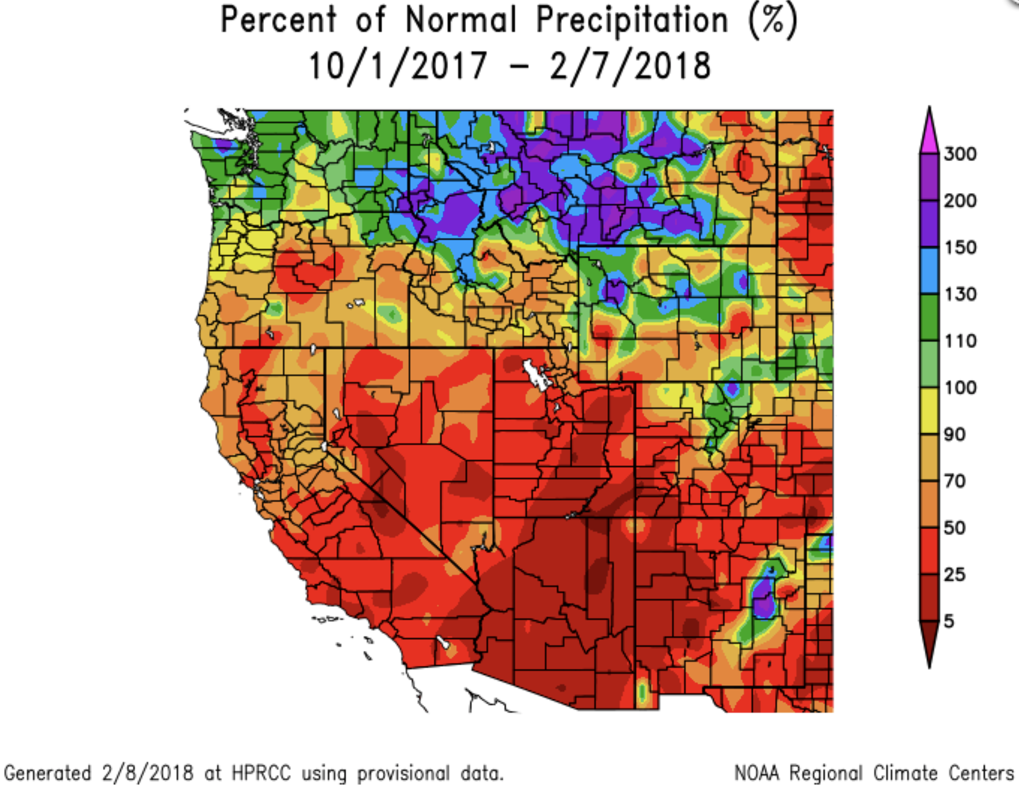
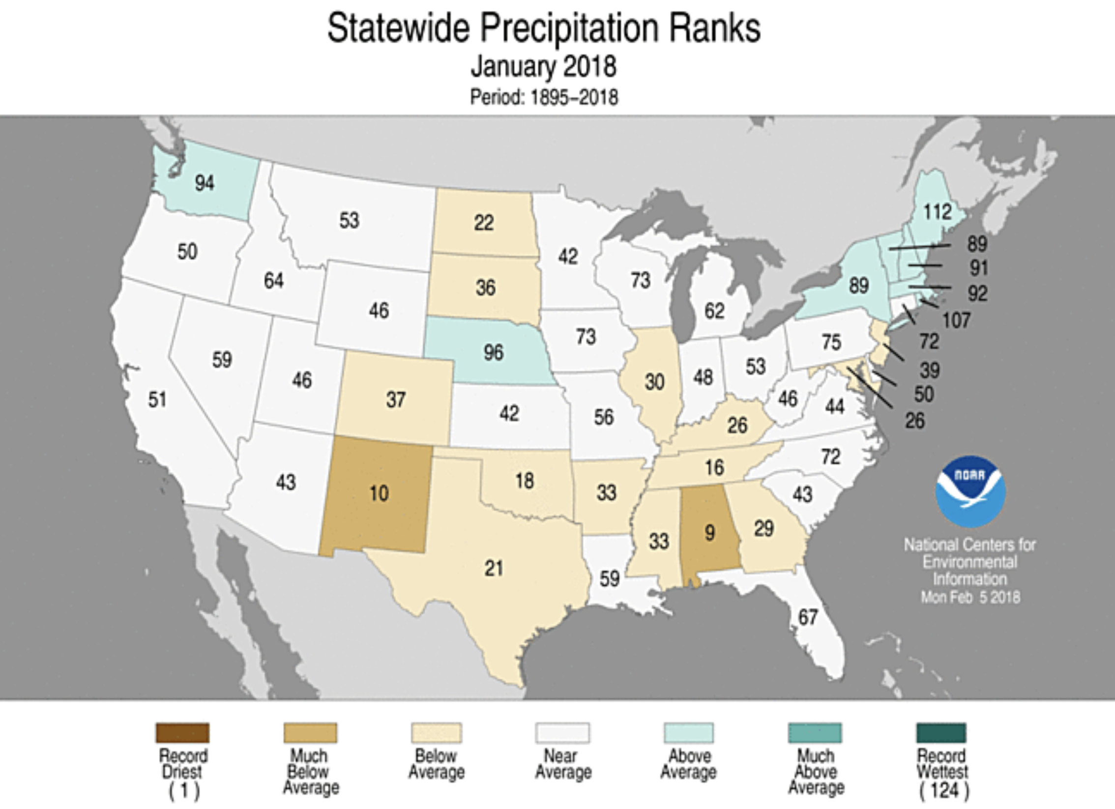
Arizonans enjoyed beautiful, warm and sunny days in January, with only 0.59 inch of rain. Temperatures were 10 to 15 degrees above normal on several days.
The entire Southwest has experienced one of the warmest, driest winters on record. That’s great for golfing, but unsettling with the unprecedented lack of snowpack runoff in the Colorado River.
Forecasts call for continued dry weather into the fast-approaching spring season…
Based on current measurements in the upper basin of the Colorado River where most of the water is generated, there is a very real possibility that the snow-water equivalent is tracking lower than 2002, which was the lowest year in recorded history.
“We do know that the runoff is not linear to what the snow-water equivalent is showing, but it is pretty alarming that we are tracking at this point in 2002, or actually a little bit below 2002,” said Tom Buschatzke, director of Arizona Department of Water Resources.
The Bureau of Reclamation has declared that there is almost no chance of a shortfall in water delivered from Lake Mead next year. But there is certainly a chance that the forecast may change, Buschatzke said…
They need to address what is happening with the hydrology and the increasing risks of not just short-term impacts on Lake Mead, but potentially going into a shortage by 2019, Bushatzke said.
“If we can’t conserve enough water in Lake Mead to make up the difference, that will be a high bar to achieve between mid-April and the end of July, which would be the time period in which we’d have to do that conservation,” the ADWR director said.
As water levels in Lake Powell and Lake Mead drop, the potential for restrictions on water use in 2019 rise, but not for all Colorado River water users.
Under the 2007 drought plan guidelines Arizona adopted, Central Arizona Project will take the full hit for whatever that reduction is, said Mark Clark, Mohave Valley Irrigation and Drainage District manager.
CAP’s hit, Clark said, is about 349,000 acre-feet of water.
“The local folk here along the river really won’t see any change due to a shortage declaration at a tier one level,” Clark explained.
In August, Bureau of Reclamation releases its 24-month study and projects out to January of 2019 whether or not Lake Mead is going to be at an elevation of less than 1,075 feet, Clark said.
“If Lake Mead is going to be at less than an elevation of 1,075 feet, a tier one shortage would be declared,” Clark said. “If it got below 1,050 feet — and the likelihood of that is pretty remote — a tier two shortage would be declared. But the likelihood of a tier one shortage declaration is pretty realistic right now.”
Arizona Department of Water Resources recently reported the entire Southwest has experienced one of the warmest, driest winters on record; snowpack in the mountain regions, which provide runoff into reservoirs like Lake Powell and Lake Mead may be at record lows…
For the past few years, the state has participated in negotiations on an updated plan known as the Drought Contingency Plan — which has not yet been signed — that would require states like California and Nevada to make earlier and deeper cuts to protect Lake Mead’s current water level, as well as an enhanced plan known as Drought Contingency Plan Plus, signed in 2017, an Arizona-based plan to help stabilize Lake Mead Water levels.
“DCP plus actually calls for more reductions before a shortage is actually declared, so that we can try and stay out of shortage, Clark said. “We were hopeful DCP was going to be signed last year, but the wheels came off the tracts a little bit and it wound up not getting signed. In fact, they’re getting further apart now than they were last year.”
Clark believes water entities, including MVIDD, will make voluntary cutbacks this year to try and keep water in Lake Mead.
“The problem with these types of voluntary programs has always been, [how do we do the accounting?],” Clark said. “If we volunteer to put water behind the dam, we don’t want to do it then have somebody else down the river takes it because we didn’t use it. We want to be sure that if we volunteer to not use water it stays behind the dam and doesn’t get used by somebody else.”
According to data taken from the NRCS, snowpack in Grand County currently sits at 102.5 percent of average. The NRCS uses a 30-year average to calculate percentage totals. Currently averages are based on snowpack figures from 1980 through 2010. In 2020 the NRCS will shift their data set and will begin using the years 1990 through 2020 as their data set for determining 30-year averages.
Those figures may come as a surprise to many residents of Middle Park who have seen local weather patterns over the past few months including seemingly below average snowfall. Vane Fulton, who works for the NRCS out of the Routt County offices, said he understands if the numbers confuse people but he is not surprised to see the current snowpack for Grand County.
“These numbers don’t surprise me,” Fulton said. “But anecdotally we don’t have low elevation snow. The SNOTEL sites are all pretty high in elevation. We don’t really track snowpack at lower elevations.”
[…]
Fulton said he recently accompanied Mark Volt, an NRCS official based out of the Kremmling office, on a series of “ground truth” snowpack measurements, wherein officials hike to predetermined locations to physically measure the snowpack. Most of the snowpack data information provided by the NRCS is taken from snowfall telemetry sites that record and log data remotely.
Volt was not available for comment Thursday morning but Fulton said that the figures found by conducting on-the-ground snow surveys confirmed the range of figures showing up on the SNOTEL data registers.
Basin-wide the snowpack for the upper Colorado River currently stands at 84 percent of average. That figure includes snowpack data from throughout north western Colorado including the Independence Pass area near Aspen and points further west as the Grand Mesa.
As the world celebrates the achievements of athletes gliding over, down and across snow, I’ve been reflecting on what I see in the mountains and for the future of these very Games. And for good reason. A team of researchers led by scientists at the University of Waterloo has found that if global emissions of greenhouse gases are not significantly reduced, only eight of the 21 cities that have hosted the Winter Olympics will be cold enough to reliably do so again by the end of this century.
Closer to home, the snowpack in the Sierra is at just 14 percent of the historical average. I never imagined I would see this in the middle of February.
But I guess I shouldn’t be surprised. The past three years were the hottest ever measured since record-keeping began in 1880, with 2016 ranking No. 1, followed by 2015 and 2017, according to the National Oceanic and Atmospheric Administration.
Scientists are warning us that the winter is becoming shorter. First freezes are starting later. So when I look at my children, I am even more convinced that we must take immediate and aggressive action on climate if we want their generation to learn these sports and enjoy winters in the mountains. More important, we must act quickly to preserve the culture and economies that depend on winter and snow.
A report to be released this month by the group Protect Our Winters, which I founded, shows that tens of thousands of jobs are at stake in mountain towns as our climate warms. In total, the 191,000 jobs supported by snow sports in the 2015-16 winter season generated $6.9 billion in wages, while adding $11.3 billion in economic value to the national economy.
Here’s a guest column from Scott Yates that is running in The Salt Lake Tribune:
This year has given us a glimpse of our potential water future in the Colorado River Basin — and it’s not pretty. So far this winter, much of the Intermountain West is seeing below average snowpack in the mountains, where most of our water in the Upper Basin originates.
Even if we end up with a good snow year, the long-term trend is clear: drier and hotter and less predictable.
Left unaddressed, these trends could pose a perfect storm for both municipalities and agricultural producers who depend on healthy flows in our rivers. That’s why a few years ago, the Bureau of Reclamation, municipal utilities, conservationists and other river stakeholders banded together to launch an innovative, market-based program, called the System Conservation Pilot Program (SCPP).
The goal of the pilot program was to answer this question: Would ranchers and farmers, landowners and other water users in the Upper Colorado Basin be willing to be paid for voluntary, temporary reductions in water use — and, by doing so, help shore up water supplies in Lakes Powell and Mead while providing side benefits like increased flows for fisheries?
We are happy to report that the answer is a resounding “yes.”
Trout Unlimited has a long track record in the West of working with the farm and ranch community on water and habitat projects. We found strong interest among agriculture producers for leasing their water on a voluntary, short-term basis to boost healthy river flows and water supply levels.
Typically, these deals involve split- or late-season fallowing — ranchers and farmers agree to irrigate for only part of their irrigation season. Season-long fallowing is also an option. The conserved water is left in the stream, undiverted, and producers receive payments for the temporary conservation use of that water.
Here in Utah, for example, six members of the Carbon Canal Company on the Price River agreed to SCPP projects that have conserved nearly 2,000 acre-feet of water and helped keep healthy flows in the Price River. The SCPP payments have created a positive buzz among other farmers and ranchers in the area. They’re seeing this as an exciting new way to use their water “crop.”
For agricultural producers, income from these temporary water transactions can boost their bottom lines and help spur investment in upgraded and more efficient irrigation systems. At the same time, these water deals send more water downstream, enhancing local fisheries, shoring up municipal water supplies and protecting hydropower capacity.
Everybody wins. Moreover, innovative tools like SCPP reduce the risk that states will fight over allocations and see every drop of water that crosses a state’s border as an economic loss.
SCPP has launched an exciting new water market for the agriculture community in the Colorado River Basin. But these new approaches will require smart, sustained investment if they’re to take root and grow.
SCPP is funded (by the Bureau of Reclamation, municipalities and others) through 2018, but beyond that, its future is uncertain — despite the popularity and proven water savings of the program.
Our organization, and our broad array of partners in the Colorado River Basin, call on our state and national lawmakers to step up and help secure long-term, sustainable funding for commonsense programs like SCPP — or this promising idea could wither on the vine.
Many river stakeholders have realized that we’ve entered a new water era that calls for cooperation, not conflict, if we want to meet our diverse water needs, such as preserving a vibrant and viable agricultural lifestyle while meeting water demands from growing cities and sustaining healthy rivers.
SCPP shows that farm and ranch country can be a collaborative part of the solution. Working together, we can keep the Colorado River and its tributaries flowing, and our farm and ranch communities healthy and productive.
The orange plume flows through the Animas across the Colorado/New Mexico state line the afternoon of Aug. 7, 2015. (Photo by Melissa May, San Juan Soil and Conservation District)
A federal judge in Albuquerque ruled Monday that certain claims can proceed in consolidated civil lawsuits filed against a contractor for the August 2015 Gold King Mine spill.
U.S. District Judge M. Christina Armijo dismissed part of a motion filed by Environmental Restoration LLC, one of the companies contracted by the U.S. Environmental Protection Agency to conduct environmental remediation at the mine.
The St. Louis-based company was among those named in separate lawsuits filed in 2016 by the state of New Mexico and the Navajo Nation.
The state and the tribe claim environmental and economic damages have occurred due to the EPA and its contractors releasing more than three million gallons of acid mine drainage and 880,000 pounds of heavy metals into the Animas River watershed as the result of a breach at the mine.
The state and the tribe are seeking compensation for the claims filed under the Comprehensive Environmental Response, Compensation and Liability Act, or CERCLA.
Environmental Restoration sought to dismiss the complaints and argued it was not liable for damages because it was not an operator, arranger or transporter as defined under CERCLA.
Armijo ruled Environmental Restoration cannot be released from the lawsuit, and the state and the tribe’s claims can proceed.
She also denied the company’s motion to strike the tribe’s request for punitive damages…
New Mexico Attorney General Hector Balderas and New Mexico Environment Department Secretary Butch Tongate issued a joint statement on Wednesday regarding the court decision.
“We are pleased that our lawsuit against EPA’s contractor, Environmental Restoration LLC, will proceed and we look forward to continuing to work alongside the Navajo Nation to recoup the damages done to our environment, cultural sites and our economy,” the statement said.
The tribe called the decision “victorious” in its press release on Wednesday.
Looking downstream from Chasm View, Painted Wall on right. Photo credit: NPS\Lisa Lynch
Click here for all the inside skinny and to register:
What is Water Fluency?
Our Water Fluency program is a professional development course for non-water professionals. Learn the language of water and develop tools for navigating water management and policy issues so you can lead with confidence.
Water is critical for every aspect of community vibrancy, from industry to commerce to agriculture, tourism, health, and the environment—but it isn’t always clear how policy and management decisions around water trickle down to affect other sectors or vice versa.
This comprehensive program will help you make those connections.
Now in its fourth year, the program has rotated around the state. This is the first year it will be hosted in the southern Front Range…
Format
Four in-person classroom days; water-focused site visits; and online discussions and homework between classroom days. The scheduled program dates are:
May 22 and 23 in Pueblo
June 22 in Colorado Springs
July 20 in Fountain
The online portion of the program is provided through a partnership with Colorado State University using their online campus to provide participants unique access to the same lectures, discussions and quizzes that degree-seeking students have.
Solar farms, wind turbines and hydroelectric dams are getting close to surpassing nuclear power plants contribution to the U.S. electrical grid, according to a new report by Bloomberg New Energy Finance.
Last year 18 percent of electrical generation came from renewable energy sources – more than double what they did a decade ago – the report said. Nuclear power plants represent 19.7 percent of the generation on the grid, according to the U.S. Department of Energy, surpassed only by coal and natural gas plants.
“The massive and historic transformation of the U.S. energy sector clicked into a higher gear in 2017, despite some new headwinds including policy uncertainties,” the report entitled “Sustainable Energy in America: 2018 Factbook” read. “Renewable deployment grew at a near- record pace.”
The growth comes even as the Trump administration has curtailed or eliminated restrictions on greenhouse gas restrictions while also trying to expand fossil-fuel production in the United States.
But so far it has done little to turn investors away from renewable energy, which is widely seen as an area of growth in the decades to come as countries try to limit the damage of climate change.
Investment in wind, solar and other renewable technologies totaled $333 billion in 2017, the second highest level on record, according to the Bloomberg report.
The impact on the atmosphere can already be seen. The expansion of renewables, as well as the shift away from coal to natural gas, has sent the nation’s greenhouse gas emissions to their lowest level since 1991, according to Bloomberg.
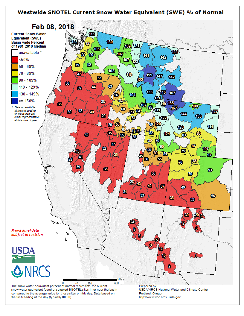
Westwide SNOTEL basin-filled map February 15, 2018 via the NRCS.
From the Environmental Defense Fund (Brian Jackson):
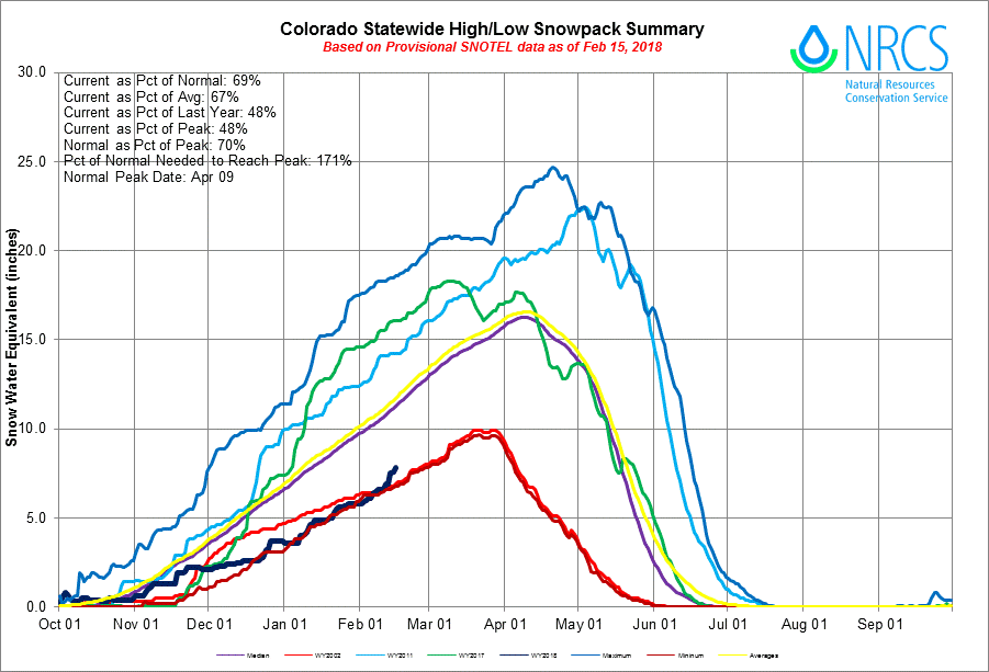
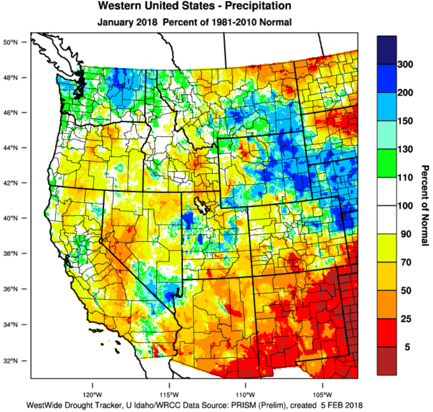
La Niña has wreaked havoc on weather systems around the country, sending storms to Baton Rouge, San Antonio and Boston, while Colorado, California and pretty much the entire Southwest United States stay dry. Colorado is at 68% of normal snowpack with the southwest Rockies in even worse shape. The Sierra Nevada snowpack – a key source of California’s water supply – is at 30% of average. Many parts of New Mexico have received less than a half inch of rain, making it one of the driest starts to a water year on record in the state.
In fact, it’s really not looking good for the entire Colorado River Basin. Earlier this month NOAA’s Colorado Basin River Forecast Center released its first forecast for 2018, predicting that spring runoff into Lake Powell would only be 54% of average. According to Jeff Lukas, who studies long-term climate shifts at the Western Water Assessment, based at the University of Colorado-Boulder, Colorado’s snowpack is “well below normal, halfway through the snow accumulation season. Essentially, time is running out to make up that deficit.”
Statewide snowpack Basin High/Low graph February 15, 2018 via the NRCS.
Is Colorado ready?
It’s certainly been a rough start to winter. And while the lack of snow is bad for snow-dependent businesses now, what does it mean for water supplies as we move into spring and summer?
Here in Colorado the dry start to winter is a sobering reminder of the importance of drought management and water conservation to maintain our quality of life and preserve our beautiful natural places. Thankfully, we’ve got the Colorado Water Plan which maps out solutions to deal with these scenarios as we move toward a warmer, drier, more populated future. Now we just need to ramp up its implementation.
Doing more with less
One advantage Colorado water managers have is flexibility. Meaning there are tools in place that can be deployed to move limited supplies of water around to where it’s needed most. During a dry year like this, that might mean moving water away from farms to meet demand in thirsty cities. Historically this would lead to farmland being pulled out of production, harming rural economies. But nowadays we have the opportunity to use flexible and innovative tools called Alternative Transfer Mechanisms (ATMs).
ATMs enable farmers to keep land available for agricultural production, while temporarily moving their water to cities, the environment or other users. This helps to maintain farmland viability in the state and introduces a new source of income for agricultural producers. This flexibility enables the state maintain a healthy agricultural economy and more easily meet water demands, even during times of drought.
The Colorado Water Plan sets a measurable objective to share at least 50,000 acre-feet of agricultural water using voluntary ATMs by 2030. Our estimates show that approximately 16,000 to 17,000 acre-feet of water is now moved annually using ATMs. That’s one piece of the puzzle, but we’ll need more rapid implementation to weather future weak snow years (and yes, they’re becoming more frequent). And we’ll certainly need to explore additional solutions if we’re going to support the projected population growth that Colorado is headed towards.
There’s still time
There is still time left in the season, and it is possible that precipitation may increase. I’m keeping my eye on a storm moving through the northern Rockies this afternoon. Maybe I’ll go skiing.
Either way, I’m thankful water managers in Colorado are ahead of the game and have taken precautions to keep reservoirs full. So far this winter has been a reminder of just how important this sort of long-term planning is. But planning isn’t enough. Now we have to actually start bringing ATMs and other solutions to fruition.
Upper Rio Grande River Basin High/Low graph February 15, 2018 via the NRCS.
Basin snowpack as of Tuesday was 45 percent of normal, not quite the lowest in the state but close, according to Pat McDermott, Colorado Division of Water Resources, who updated members of the Rio Grande Roundtable during their February 13th meeting. The San Miguel, Dolores, Animas basin is a percentage lower, with the best snowpack in the state 95 percent of normal in the South Platte River Basin on Tuesday, with other basins everywhere in between…
Putting perspective on both ends of the spectrum, last year the snowpack was 152 percent of normal on February 8, but the drought year of 2002 was 25 percent of normal, McDermott pointed out. He said he realistically expected a year in the range of 2003 with about 45-50 percent of average annual runoff…
Currently the Natural Resources Conservation Service (NRCS) is forecasting an annual flow of the Rio Grande at Del Norte at 340,000 acre feet with 83,800 acre feet obligated to downstream states as part of the Rio Grande Compact, requiring about 5 percent initial curtailment to meet that obligation.
McDermott said Colorado is currently in a debit status with the Rio Grande Compact for the first time in 30 years, with about 1,300 acre feet under delivered. Considering the abundant water year that 2017 was, however, that is a minimal amount, he added.
The NRCS current forecasted annual flow on the Conejos River systems is 160,000 acre feet or about 54 percent of normal, which would require 25,000 acre feet to be sent downstream and a curtailment of only about 1 percent at the beginning of the irrigation season.
The irrigation season could start early on the Conejos so the system does not over-deliver, McDermott said. The irrigation season is set from April 1 to November 1, but the water division office has some latitude, and Division Engineer Craig Cotten has granted a few one-time variances due to low snowpack and warm weather, McDermott said. Farmers must submit written requests to be considered for irrigation season variances…
The National Weather Service’s forecast for March, April and May (and through the summer) is warmer for this region with precipitation below normal at least into the summer.
FromThe Colorado Springs Independent (J. Adrian Stanley):
…the experts say it’s not time to panic. Yet. There’s still two months ahead that could bring more snow, and that could be enough to lower fire danger until the area’s June monsoon rains come. But that’s assuming that normal weather patterns start kicking in, and you know what they say about assumptions…
There are many factors that lead to massive, destructive wildfires. There’s the moisture level in everything from “flashy” fuels like grasses and shrubs to large-diameter trees. There’s wind. Humidity. Daily highs and lows.
But it doesn’t take a genius to know that the winter’s snow pack is a huge factor. Russ Mann, fire meteorologist with the Rocky Mountain Area Coordination Center in Denver, says that it’s too early to know if trees in our area are low enough on moisture to increase the likelihood of a fire. They’re dormant right now, and you can’t accurately measure the levels, he says.
But other conditions look less than ideal. The region, he says, is in a moderate drought, with the areas to the south and southwest of us experiencing a severe drought (a couple steps down from the worst-case scenario).
Asked to compare drought conditions on Feb. 7, 2012 — months before Waldo — to the conditions on Feb. 7, 2018, Mann paused to pull up the maps and study them. “It’s not as bad as we have now,” he said.
Likewise, asked to compare this winter to the one that preceded Hayman, the largest fire in the state’s recorded history, Mozley noted that our region’s snow pack stood at 20 to 30 percent of the norm, with about two months left of winter to make it up. The winter before Hayman, our region saw 67 percent of normal snow pack…
Kathy Torgerson, lead forecaster and meteorologist with the NWS Pueblo, says that climate change is always a factor. Every 10 years, she says, NWS resets “average highs and lows” and every time they get higher. Likewise, as climate science would predict, heavy rainstorms still hit the area in summer, but they are less frequent. (Some may remember the once predictable afternoon showers in summer.)
But the crazy weather this year, she says, is more related to a La Niña weather pattern that’s concentrated moisture in northern states and northern Colorado, while leaving the southern part of the state parched…
While it’s notoriously difficult to predict weather far into the future, Torgerson says signals do not point to a wet spring. And even if we do get quite a bit more moisture in the remainder of winter and spring, all meteorologists consulted for this story agreed that it wouldn’t make up the deficit.
It’s too early to predict if the summer monsoon season will be particularly wet, though Mozley noted that autumn, at least, will likely bring relief. There are already signals that winter 2018-19 will follow an El Niño pattern, bringing moisture to the area.
In the meantime, locals are bracing themselves. Jim Reid, executive director of El Paso County’s Office of Emergency Management, says that with the ground hard and dry, he’s less worried about fires than he is about floods caused by hard spring rains that fail to absorb. Such storms have wiped out roads in the past, he notes.
Dave Condit, deputy forest and grassland supervisor for the Pike and San Isabel National Forests and Cimarron and Comanche National Grasslands, says he is concerned about fire, but he’s also worried that his teams may not be able to conduct controlled burns in spring due to dry, windy conditions and low moisture in plants and trees…
City Forester Dennis Will says he frets more about the trees in city parks dying than he does about the native trees in the city’s open spaces. We’ve had a couple wet years, he notes, and native trees are hardy enough to survive around five severe droughts in their lifespan.
More than a foot of snow fell atop Aspen Mountain between midnight and 4 p.m. Thursday, according to the Aspen Mountain ski patrol station located at the top of the Gentleman’s Ridge lift.
Click here to read the newsletter. Here’s an excerpt:
Crews from Northern Water work to maintain hydroelectric plant equipment
Workers from Northern Water have taken apart some of the equipment at the Robert V. Trout Hydroelectric Plant at the outlet of Carter Lake as part of the organization’s annual maintenance program for the facility.
On Feb. 8, members of the Northern Water board of directors were told that 2017 was a strong year for electricity production at the plant. Energy is captured from the outlet at Carter Lake as water is delivered into the St. Vrain Supply Canal. That electricity is marketed through the Poudre Valley Rural Electric Association to customers throughout the utility’s service area on the Front Range.
The power plant, one of two hydroelectric generation plants owned by Northern Water, has been in operation since 2012 and is authorized through a Lease of Power Privilege agreement with the U.S. Bureau of Reclamation. In addition to Northern’s two hydroelectric plants, Reclamation operates six additional Colorado-Big Thompson generation stations that supply renewable energy throughout the American West.
Click here to go to the US Drought Monitor website. Here’s an excerpt:
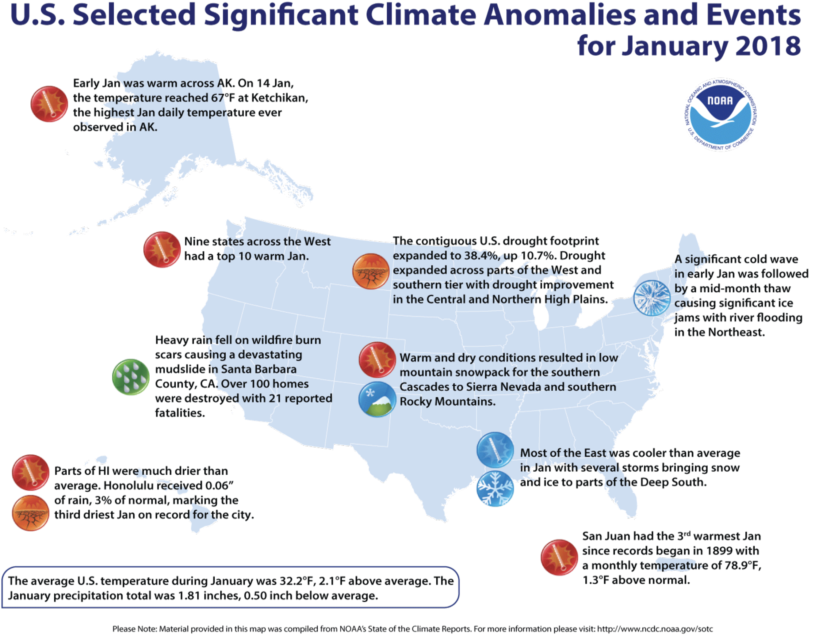
Summary
During the 7-day period (ending Tuesday morning), heavy to excessive rainfall eased or eliminated dryness and drought across much of the eastern, southeastern, and southcentral U.S. Conversely, drought intensified and expanded from the central Corn Belt southwestward across the southern Plains into the Southwest, including much of southern California. Other modest changes to the nation’s drought depiction over the past 7 days included reductions to drought intensity in Montana as a result of recent snowy, cold weather, while dryness and drought expanded in Oregon due in large part to subpar snowpacks…
South
For the second consecutive week, moderate to heavy rain in eastern portions of the region contrasted with intensifying drought across the southern Plains and environs. Rainfall totaled 2 to 6 inches from eastern Texas into Tennessee, with two-week totals of 6 inches or more in east-central Mississippi. The net result was a widespread reduction of Abnormal Dryness (D0) and Moderate to Severe Drought (D1 and D2). Despite the moisture, longer-term deficits persisted in the Delta’s core D1 area, with 90-day precipitation 50 to 70 percent of normal (locally less). Farther west, Extreme Drought (D3) expanded further across northern Texas, with even more notable increases in D2 in central Texas. The drought situation remained unchanged in Oklahoma, with rain sorely needed as warmer weather begins to stimulate the growth of crops and vegetation. From Lubbock, Texas, northward into Oklahoma, little — if any — precipitation has fallen over the past 90 to 120 days; the four-month Standardized Precipitation Index (SPI) was well below D4 levels (-2.0 or lower, with some below -3.0) in these locales. The lack of rainfall is affecting winter wheat, pastures, pond levels, and streamflows. Impacts will rapidly escalate if rain does not materialize soon. To put the dryness in perspective, February 14th marked the 124th consecutive day without rain in Amarillo, shattering the previous mark of 75 days (records date back to 1892). In Lubbock, February 14 marked the 98th consecutive day without measurable precipitation, tying the record. Other notables in Texas include Plainview and Memphis, which are both now at 130 days without measureable precipitation. Similar statistics are emanating out of Oklahoma, where Woodward and Laverne just reached 127 days without measureable precipitation as of February 14. The situation on the southern Plains is rapidly becoming dire, and precipitation will be needed soon to prevent further expansion or intensification of drought…
High Plains
Additional snow in central portions of the region contrasted with dry conditions elsewhere. There were no changes made to the drought depiction in the Dakotas, where a lack of snowfall to date has led to declining prospects for spring meltoff; resultant detrimental impacts on topsoil moisture and stock pond levels remained a primary concern. Meanwhile, a continuation of the recent snowy weather pattern in northeastern Colorado, southeastern Wyoming, northwestern Kansas, and much of Nebraska (30-day surplus of 1-2 inches, liquid equivalent) supported the reduction of Moderate Drought (D1) and Abnormal Dryness (D0). Likewise, moderate to heavy snow (depths averaging 12 to 24 inches, liquid equivalent 1 to 2 inches) in northeastern Montana supported some reduction of the state’s persistent long-term drought. Conversely, southern Kansas remained locked in the same drought which has held a firm, intensifying grip on the southern Plains. However, additional detailed assessment of data coupled with information from the field led to a minor adjustment of the Extreme Drought (D3) which slices over the south-central U.S., with the depiction shifted slightly east from southeastern Colorado into western Oklahoma to reflect the updated information.
West
Outside of bitter cold, snowy weather in the northeastern corner of the region, warm and mostly dry conditions prevailed. In Montana, moderate to heavy snow (depths averaging 12 to 24 inches, liquid equivalent 1 to 2 inches) in northern and eastern portions of the state supported some reduction of the state’s persistent long-term drought. Meanwhile, an increasingly poor Water Year as well as historically low mountain snowpacks led to the continuation or expansion of dryness and drought. In southwestern Colorado, Severe Drought (D2) was expanded slightly to the northeast of the San Juan Mountains, as the southwestern corner of the state continues to wrestle with sub-par season-to-date precipitation (locally less than 25 percent of normal since October 1) and very poor mountain Snow Water Equivalent (SWE) for spring runoff. More notably, D3 was added in northern New Mexico where SWE’s are at or near 0. In fact, similarly abysmal SWE’s encompass much of the Four Corners States into northern Nevada and — to a lesser extent — the Sierra Nevada. The Drought Monitor and local experts will continue to closely monitor the snowpack situation over the upcoming weeks. Exacerbating the situation has been the very poor Water Year, with precipitation-to-date totaling less than 25 percent of normal over large tracts of southern California and the Southwest; Severe Drought (D2) was expanded accordingly to reflect the driest areas. Conditions also have begun to slip farther north as well. Moderate Drought (D1) was added to Oregon and northern Nevada, where precipitation during the current Water Year has slipped below 50 percent of normal and mountain SWE’s are in the 10th percentile or lower…
Looking Ahead
An unsettled weather pattern will maintain periods of rain and snow over much of the nation, although pockets of dryness will persist. A series of storms will bring moderate to heavy rain and mountain snow to much of the west, although unfavorably dry conditions will persist from California into western Nevada. East of the Rockies, an active southern storm track will bring much-needed precipitation to locales from southeastern New Mexico across the southern two thirds of Texas into southern Oklahoma and the northern Delta. Despite the welcomed storminess, dry weather will linger from the south-central Plains into western Missouri as well as over the lower Southeast. Farther north, another round of moderate to heavy snow is expected from Montana into the Great Lakes and eastern Corn Belt, and may include the Mid-Atlantic as well as Northeastern States. The NWS 6- to 10-day outlook for February 20 – 24 calls for near- to above-normal precipitation over much of the nation, in particular areas east of the Mississippi save for Florida and the lower Southeast, where drier-than-normal conditions are expected. Below-normal precipitation is also anticipated in the Southwest and on the southern High Plains. Above-normal temperatures over the southern and eastern U.S. will contrast with colder-than-normal weather from the Pacific Coast States into the upper Midwest.
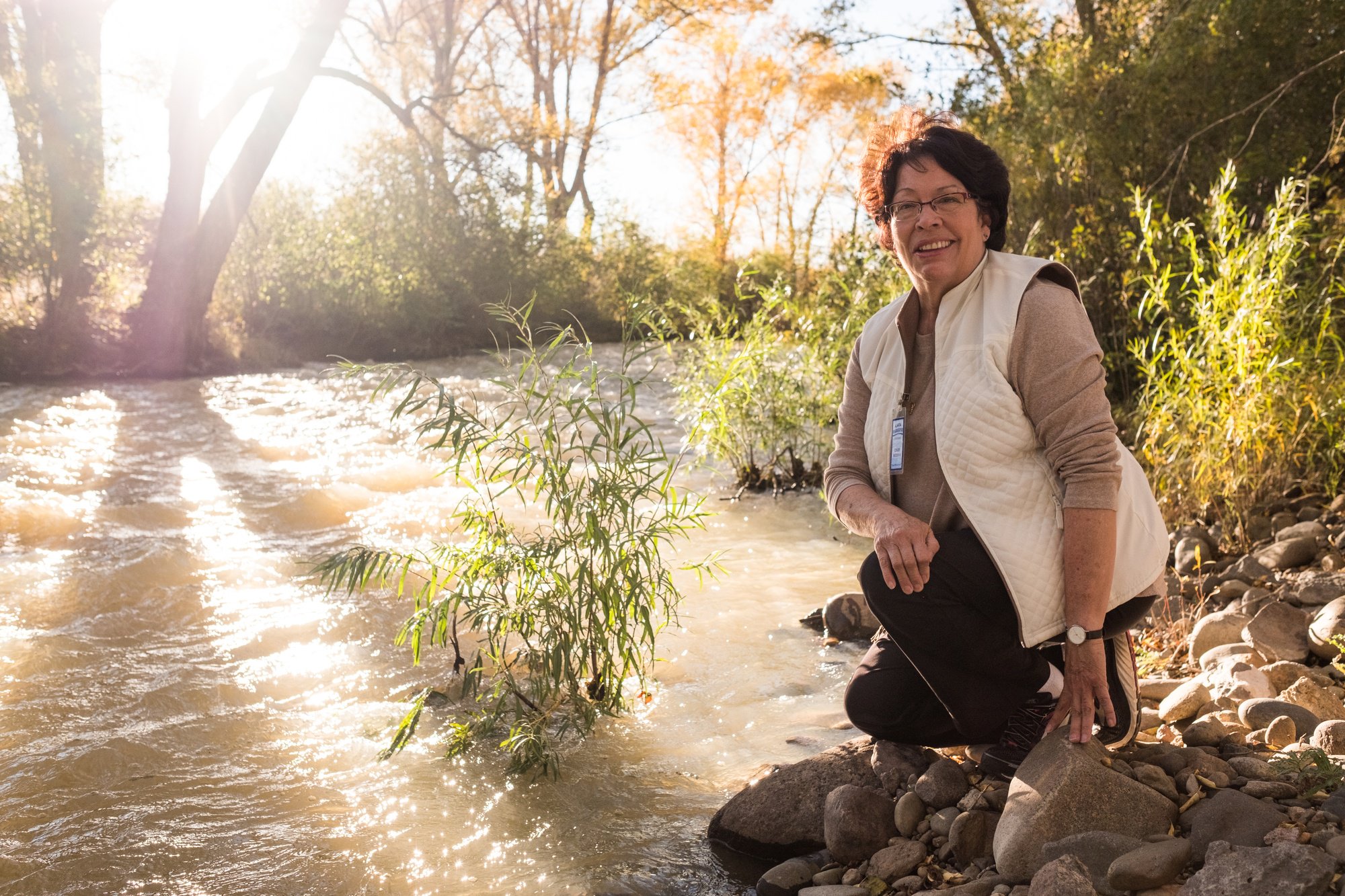
Here’s a profile of Cindy Medina and her work with the Alamosa Riverkeeper via the Waterkeeper Alliance (Lesley Adams and Kate Hudson). Click through and read the whole article. Here’s an excerpt:
Inspired by the leadership of Alamosa Riverkeeper Cindy Medina, a community united to bring the Alamosa River back to life.
The San Luis Valley and the headwaters of the Alamosa River rest between the snow-capped peaks of the Sangre de Cristo and San Juan Mountains of southern Colorado rest. Rising more than 14,000 feet above sea level, the “Blood of Christ” mountains are the southern tip of the Rockies and stretch over the New Mexico border to where the Kapota Ute Indians once lived.
Three centuries ago, Spanish settlers came north from what was then Mexico and settled in the San Luis Valley, where they took root amidst the cottonwood and aspen trees along the Alamosa River and became farmers and ranchers with an unflagging commitment to hard work and their Catholic faith. Cindy Medina, a present-day descendant of one of those families, became one of the first women to join the Waterkeeper movement.
Photo credit: Wenck
The middle child of seven girls, Cindy was raised on a farm, helping with chores, playing in alfalfa fields, and splashing around in the irrigation ditch, called an acequia, that brought water to the farm. In her memoir, A Journey into the Heart of the Black Madonna, Cindy wrote lovingly of her family, whose pulsating force sustained her as a girl. Her memories of growing up in the San Luis Valley send aromas through the pages – of fresh tortillas and cinnamon rolls made by her mother, of the home-heating fires fueled by wood gathered in the mountains with her grandfather, of the potent herbal remedies wild-crafted by her grandmother. Her connections to family and the natural world around her were woven together. She wrote: “This lifeblood was no different than the acequia, the ditches lined with dirt that irrigated this arid land with water. . . The acequia was my ocean.”
Cindy Medina photo credit: Waterkeeper.org.
Like many others in the rural West, Cindy left as a young adult to pursue a formal education. She earned a master’s degree in counseling from Arizona State University and relocated with her husband to Seattle. There she began a successful practice as a psychotherapist, gave birth to two daughters and, while on a trip to Zurich, Switzerland to attend a psychology seminar, came across an 8th century statue of the Black Madonna at a Benedictine Abbey and experienced a spiritual transformation that led her to environmental activism. The Black Madonna is considered by some to be the Queen of Nature,” Cindy explains, “and the archetypal energy that fuels change.” She is the mother who fertilizes all life and urgently demands a return to balance and wholeness, honoring the earth. In her memoir, Cindy describes her encounter with the Black Madonna as a spiritual awakening to the interconnectedness of all living things. In 1988, propelled by that journey of self-discovery, Cindy moved back home to southern Colorado, where she found that a pollution crisis threatened the heart of her community, the Alamosa River.
Summitville Mine superfund site
Gold, Greed and Cyanide
The mountains in southern Colorado are rich in minerals, gold and silver, which attracted extensive mining in the late-19th and early-20th centuries. And, in turn, like all boom-and-bust extraction, the mines left a toxic legacy. Acid mine drainage polluted and continues to pollute many Colorado waterways downstream. Mining in high-elevation areas like the San Juan Mountains petered out in the 1920s, and remained dormant for more than half a century, until a new, far more destructive method was developed to allow precious metals to be recovered from otherwise uneconomic ore.
In 1984, Canadian-based Galactic Resources and its subsidiary, Summitville Consolidated Mining Company (named for the local ghost town) acquired 1,230 acres of the San Juan Mountains that loomed above the San Luis Valley, and convinced the state of Colorado to grant them a mining permit for a new “state of the art” mining technique known as “heap leaching” – large-scale open-pit mining that involved slicing off half the side of a mountain and putting the mined ore in a lined open pit (“heap-leach pad”) with sodium cyanide to leach out the copper, gold and silver. This “state of the art” technique was efficient for the mining company, but disastrous for those who lived downstream. The liner of this pit almost immediately sprung leaks, contaminating nearby creeks with heavy metals and acid, and creating a 17-mile dead zone and a massive fish kill in the 51-mile-long Alamosa River.
If SCOTUS holds in Texas v. New Mexico and Colorado that the United States has an independent cause of action under the Rio Grande Compact, it could open the door for the federal government to sue states for violating the terms of other interstate water compacts. [11] Depending on the scope of the ruling, it could either set a precedent for claims by the United States in other interstate water disputes or be narrowly limited to the facts of the case. Included at the end of this alert is a map showing all current interstate compacts.
From a practitioner’s perspective, the issues at the crux of Florida v. Georgia highlight the need for clear guidance from technical experts in determining priorities in complex allocations. Moreover, the decision will have implications for how SCOTUS may handle equitable apportionment in future water disputes, such as between Mississippi and Tennessee. [12] There is a dearth of recent case law on equitable apportionment, particularly in Eastern states; the last time SCOTUS equitably apportioned water between Eastern states was 1931, when it resolved a conflict between New Jersey and New York. [13] There also is a lack of precedent as to how the Court will treat considerations of ecological impacts in equitable apportionment. Whether the decision in Florida v. Georgia will provide clear insights into these issues remains to be seen, but if it does, it will certainly impact upcoming interstate water disputes.
Conclusion
The allocation of water from interstate compacts directly impacts the amount of water available to users within the party states. Thus, the outcome of these two cases apportioning water between and among states, and deciding the role of the federal government in that distribution, will have impacts across various economic sectors, including agriculture, power production, municipal water supply, food processing, technology manufacturing, and data storage, to name a few.
Water quality is a sticking point for Thornton, which faces challenges getting all its water to drinking quality standards. Much of the city’s water comes from the South Platte River and requires extensive treatment because it’s diverted downstream of many areas of runoff and pollution, [Emily] Hunt said.
If Thornton drew the water from the Poudre near Windsor as suggested, the city would end up with water run downstream of three wastewater treatment plants and numerous runoff areas, [Mark] Koleber said.
“Urban runoff, agricultural runoff, wastewater plants, industrial discharge — it’s just not what you do for a municipal drinking water supply,” he said.
Especially considering Thornton bought the [rights to divert] because of its high quality, Hunt added.
Here’s the release from Governor Hickenlooper’s office:
The Colorado Oil and Gas Conservation Commission (COGCC) today approved comprehensive new regulations addressing oversight of flowlines and related infrastructure associated with oil and gas development.
The nine-member commission unanimously approved the updated regulations following three days of testimony from the public, local governments, homebuilders, citizen groups, trade associations and members of the oil and gas industry on more than 20 pages of proposed new and amended rules.
“We believe these new rules are another important step in the aftermath of the Firestone tragedy,” said Governor John Hickenlooper. “State government and local municipalities depend on the commitment that industry is doing everything to to keep our communities safe.”
The flowline rules take numerous steps to strengthen requirements for design, installation, maintenance, testing, tracking and abandoning flowlines. Flowlines describe the kinds of pipelines that most typically move fluids around specific oil and gas development locations from wells to separators to storage tanks or to larger pipelines.
The new rules include dozens of changes and improvements to flowline oversight, including:
Requirements for more detailed tracking, location data and record-keeping for flowlines that carry fluids away from a specific oil and gas location, such as lines that may travel from a well to a storage tank not co-located on the same wellpad, or to a gathering line. The rule permits COGCC to share resulting, more specific geospatial information with local governments through a confidentiality agreement.
Requirements that any flowlines not in use – but not yet abandoned – are locked and marked. All such lines must continue to undergo integrity testing under the same standards as active lines until abandonment. Any risers associated with abandoned flowlines must be cut below grade. This rule change makes permanent the post-Firestone order to eliminate above-ground risers connected to abandoned flowlines.
More detailed requirements for operators to demonstrate flowline integrity, including updated standards for integrity-testing lines, more testing options that align with newer technology, and the elimination of pressure-testing exemptions for low pressure lines.
Requirements for full operator participation in the Utility Notification Center of Colorado’s “one-call” program to ensure a centralized home for all data on flowline locations and access to that information through the established 811 “call-before-you-dig” system.
The new flowline rules and enhanced participation by operators in 811 include three key components of state actions outlined by Gov. Hickenlooper following a three-month review of oil and gas operations last year. The review followed the home explosion in Firestone last April that killed two people and injured a third.
“Our work with operators last spring and summer to identify, quantify and test all flowlines near residential areas was a significant start,” said COGCC director Matt Lepore. “These rules – and additional actions ordered by the Governor that are still unfolding – continue to keep our focus on this work.”
The final draft of the proposed rules can be found here, and an overview of the COGCC’s basis and purpose for the rules here. The latter provides context and analysis for the rulemaking. All documents associated with the rulemaking, including formal statements from parties to the hearing, are housed here.
The Commission also directed COGCC staff to empanel a stakeholder group representing a cross-section of interests to review current and developing instrument-based technologies and methods for preventing or detecting leaks and spills from flowlines. COGCC staff will present to the Commission quarterly on the group’s progress with a final presentation of the results of the stakeholder group’s study, along with any associated recommendations for changes to COGCC’s policies or rules, within a year.
The flowline rulemaking is the latest in a consistent and long-running effort to strengthen the regulatory oversight of the COGCC, dating to 2008.
The COGCC, under the Hickenlooper Administration, has crafted rules to increase distances between drilling and neighborhoods; reduce the effects of light, noise and odors; protect groundwater; reduce air emissions in partnership with the Colorado Department of Public Health and Environment; disclose hydraulic fracturing chemicals; tighten requirements for spill reporting; significantly elevate penalties for operators violating Commission rules; toughen requirements for operating in floodplains; and amplify the role of local governments in siting large operations near communities.
The Commission has also significantly expanded inspection, engineering, reclamation, and environmental staff; increased ease of access and the volume of data available to the public; intensified collaboration with local governments; sponsored ongoing studies to increase understanding of impacts to air and water; and adopted several formal policies to address health, safety, and environmental issues brought about by new technologies, all while experiencing an unprecedented increase in oil and gas development in Colorado.
The rules are intended to prevent a repeat of the April 17 explosion that killed two people, injured a third and destroyed a house in the town of Firestone, about 30 miles (50 kilometers) north of Denver. Investigators said the explosion was caused by odorless, unrefined natural gas from a severed flow line.
The line was believed to be abandoned but was still connected to an operating well with the valve turned to the open position, investigators said.
The flow line was severed about 10 feet (3 meters) from the house, and gas seeped into the home’s basement, investigators said. The well and pipeline were in place several years before the house was built.
Colorado has nearly 129,000 flow lines within about 1,000 feet (300 meters) of occupied buildings, according to energy company reports submitted to the state last year.
The proximity of oil and gas wells to homes and schools is a contentious issue in Colorado, especially in the fast-growing Front Range urban corrido, which overlaps with an oil and gas field. Firestone is in the midst of the growth area.
The new regulations says flow lines that are permanently taken out of service must be disconnected, drained and sealed at both ends and any above-ground portion must be removed. The rules also allow energy companies to simply remove the lines.
The proposal also requires energy companies to provide information on the location of flow lines to the Call 811 program, which marks the site of underground utilities at a property owner’s request. That’s meant to help homeowners and construction companies avoid inadvertently severing a line.
Directional drilling from one well site via the National Science Foundation
Westwide SNOTEL basin-filled map February 14, 2018 via the NRCS.
From the Craig Daily Press (Eleanor C. Hasenbeck):
According to the Natural Resources Conservation Service, the Yampa River basin has received 73 percent of the average amount of snow it typically receives by this time of year. The Little Snake River basin has received 72 percent. In river basins in the southwest and south central part of the state, this number is in the 30s.
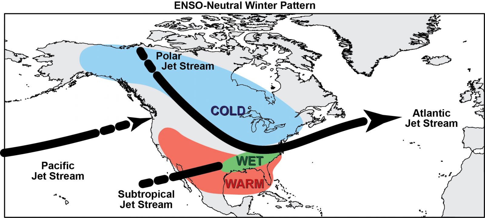
The drastic difference in snowpack between the northern and southern parts of the state is thanks to the La Niña winter. La Niña is a weather phase that cools the waters of the Pacific.
A La Niña year influences weather patterns around the globe, but in the United States, it creates a ridge of high pressure in the West. Storms develop in the moist air of the Pacific Northwest, then ride the jet stream on the northern edge of this high-pressure ridge.
National Weather Service meteorologist Megan Stackhouse calls these storms “northern clippers.” They typically hit only the northern edge of Colorado.
According to the U.S. Drought Monitor, all of Colorado (except a sliver at the northern edge, containing Larimer and Jackson counties) is facing drought or near-drought conditions.
Eastern Moffat County is abnormally dry, which is a pre-cursor to a drought designation. West of Maybell, the county is in a moderate drought. Steamboat Springs is also in a moderate drought, which could have implications for Moffat County, as snowpack in the Park Range melts into Moffat’s water supply.
Stackhouse said it would take 40 to 60 inches of snow for the Yampa/White River basin to reach an average level of precipitation for this water year. Receiving that much snow is not out of the question, though it’s unlikely.
With this in mind, Tom Gray, Moffat County’s representative to the Colorado River District, cautions the public not to panic before it’s warranted. In 2015, he said, Northwest Colorado faced a similar light snow year. Then, there was a “miracle May.” Mountain storms dumped snow late in the season and brought the basin back up to the average…
Gray and others at the Colorado River District are worried about meeting obligations under the Colorado River Compact. Under the agreement, the state of Colorado is required to contribute a 10-year rolling average amount of water downstream to the Colorado River system to help fill reservoirs such as Lake Powell.
So far, Colorado is set to contribute about 40 percent of its average annual contribution, according to Jim Pokrandt, director of community affairs at the Colorado River District.
That puts Colorado on track to send the smallest amount of water downstream to Lake Powell in the past 10 years, according to data from the Colorado Basin River Forecast Center. This could cause shortages to water users in parts of California, Utah, Arizona and New Mexico.,,
Closer to home, the Stagecoach and Elkhead reservoirs are on track to be filled. These reservoirs are relatively small, however, which makes them easier to fill.
But unless more snow comes, rural Moffat County is likely to feel the impact.
“If you start the spring with not-very-good soil moisture levels, and then, through April and May, if we don’t get rain to get some soil moisture, you’re that much drier,” Gray said.
For farmers, this could mean a weaker hay crop, as water to irrigate isn’t there. Dry soil also means dry grasses, which are better fuel for wildfire.
For now, residents of Northwest Colorado can kick off their snowshoes and hope to receive more moisture to avoid a drought. The weekend snowstorms helped.
“Statewide snowpack for Colorado approximately went up 5 percent with this last storm,” Stackhouse said in an email. “But that is very preliminary, since we are still collecting and receiving reports with this storm.”
Lake Powell April 12, 2017. Photo credit Patti Weeks via Earth Science Picture of the day.
Click here to read the newsletter. Here’s an excerpt:
Should Coloradoans Care about Water Levels in Lake Powell?
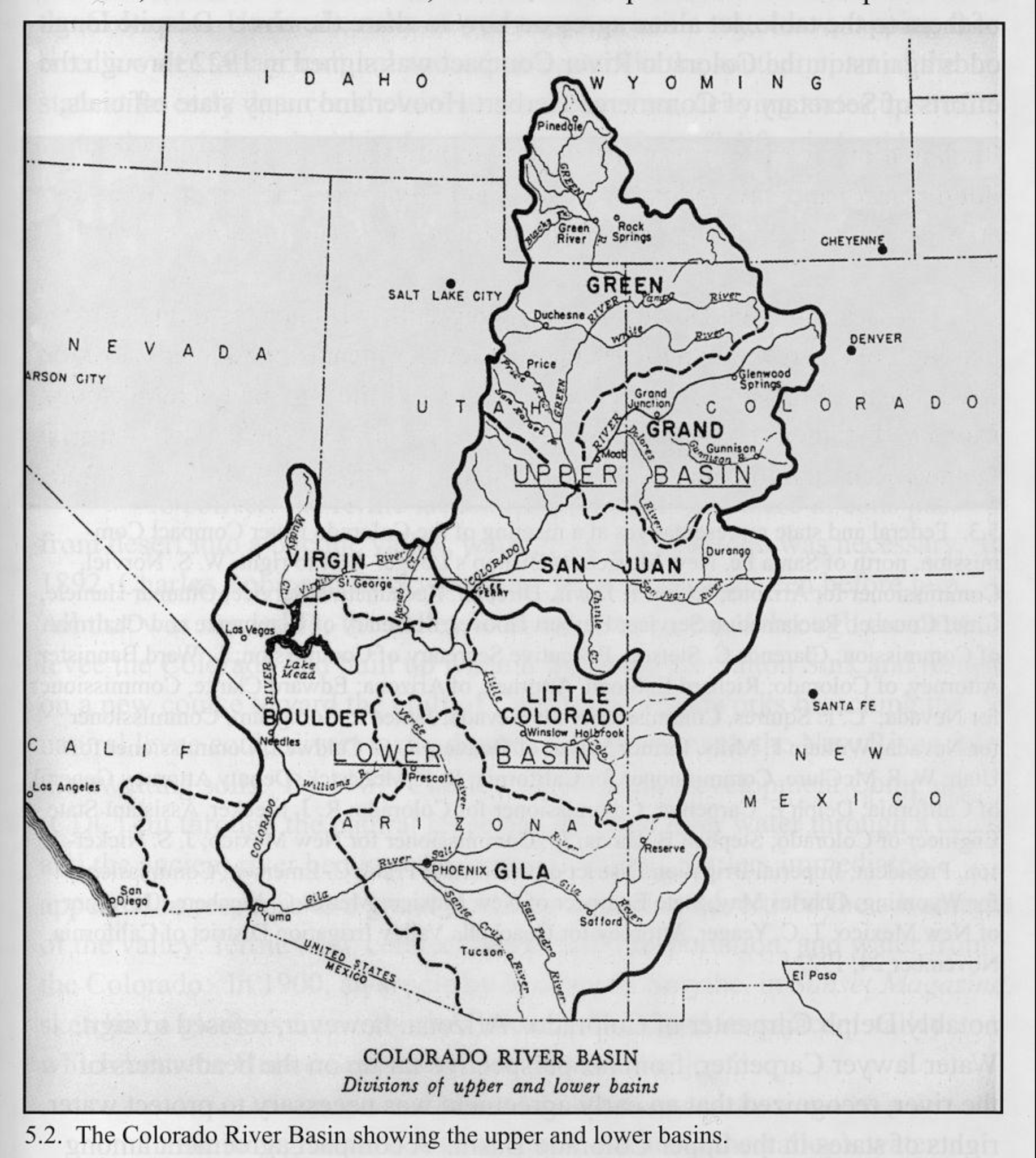
We occasionally hear about declining lake levels in Lake Powell or Lake Mead, but – apart from being nice places to boat and fish – what is the relevance of these water bodies to Colorado agricultural producers and rural residents? To understand this, we need to go back almost 100 years to the signing of the Colorado River Compact.
Under the 1922 Compact, Colorado and the rest of the Upper Basin states – Utah, Wyoming, New Mexico – have a shared obligation “not to deplete” the river by more than 7.5 MAF (million acre-feet) per year on average, or 75 MAF over a 10-year period. The three lower basin states – Arizona, Nevada and California – also have an allocation of 7.5 MAF per year, and Mexico gets 1.5 MAF. The Compact essentially obligated the river to supply up to 16.5 MAF per year, which was thought to roughly represent the long-term annual average flow of the Colorado River based on an estimate made at the time.
The problem – as it turned out – was that the original estimate was high. The period 1905-1922, which was used to estimate water production allocated under the 1922 Compact had the highest long-term annual flow volume in the 20th century, averaging 16.1 M acre-feet per year at Lee’s Ferry, AZ. Since then, the average flow has been about 13.9 MAF.
The collective water use of the four Upper Basin states is still well below the 7.5 million acre-feet annual average depletion allowance. U.S. Bureau of Reclamation 5-year retrospective “Consumptive Use and Loss” reports indicate that the Upper Basin water use averaged 4.4 MAF between 2000 and 2015. The highest use among these years was 4.9 MAF.
The Lower Basin states, with greater population and higher evapotranspiration, have a more difficult time managing water demands within the limitations of the Compact. For the last several years, annual releases from Lake Mead have averaged about 9 MAF to meet lower basin water demands. However, Lower Basin water users receive credits for unused return flows. Lake Mead also loses about 1.2 MAF in evaporative and system losses, so the total annual outflow from Lake Mead has been about 10.2 MAF.
The imbalance between Lake Mead’s long-term inflows and outflows is called the “structural deficit.” This volume is estimated to be approximately 1.2 MAF annually. Lower Basin water users, including Mexico, are developing a Drought Contingency Plan (DCP) to address this imbalance by using a comprehensive demand management system that will better match deliveries to variable, and generally diminishing inflows into Lake Mead.
Lake Powell stores water that flows from the Upper Colorado River basin and is used to buffer declines in Lake Mead. Glen Canyon Dam – which creates Lake Powell – also has turbines that generate 5 Billion kilowatt-hours of hydroelectric power annually. The Western Area Power Administration (WAPA) distributes this electricity to Colorado and six other states at cost-effective rates. The total value of the electricity produced is about $120 M annually. A small but important portion of the annual power revenue is used to fund salinity control programs that help pay for irrigation infrastructure upgrades on the western slope, and provide funding for the Colorado River and San Juan River endangered species recovery programs.
In 1970, formal “Operating Criteria” were agreed upon by the seven states and the Bureau of Reclamation to provide for the coordinated operation of reservoirs in the Upper and Lower basins and set conditions for water releases from Lake Powell and Lake Mead.6 In 2007, interim criteria were established to specifically enable coordinated operation of Lake Powell and Lake Mead that would “minimize shortages in the Lower Basin and help avoid the risk of curtailments in the Upper Basin.” These interim criteria are based on specified reservoir conditions.
Operating Criteria allow the Secretary of the Interior to make releases from Lake Powell to raise the water level in Lake Mead so that the stored volume of the two reservoirs is roughly equal. The upshot is that Lake Powell declines when Lake Mead declines, even if ample flow is entering Lake Powell from the upper basin states.
Since 2000, the two reservoirs have fallen to approximately half of their combined capacity in response to hydrological conditions and to meet Lower Basin water needs and Upper Basin power needs. The current water level of Lake Mead – 1,087 feet above sea level – remains above the “Tier 1 Shortage level” of 1,075 feet, which is the point where water allocations to Arizona and Nevada are reduced under the Interim Operating Guidelines. These reductions become increasingly severe at Tier 2 and Tier 3 levels.
The current level of Lake Powell is about 3,619 feet above sea level. The concern for the Upper Basin states is that if the structural deficit continues and/or a drought returns, Lake Powell could fall to a level below 3,490 feet, which is the minimum level needed to generate electricity (ie. the “power pool”).
The Lower Basin states and Mexico have implemented conservation measures that have saved about 1.2 million acre-feet in Lake Mead since 2014. This has resulted in the lake level being 14 feet higher than it would have been otherwise.
For Colorado and the other upper basin states, the challenge isn’t complying with the depletion limit spelled out in the 1922 Compact. Instead, it is simply how to deal with snowpack variability and potential water supply shortages over a multi-year period. Since many Front Range cities and east-slope irrigation districts rely on Colorado River Basin water via trans-mountain diversions, runoff shortages on the western slope also directly affect eastern slope residents and farmers. And of course, multiple years of drought in the upper basin could result in lowering of Lake Powell to the power pool level simply because of inadequate runoff. When the 2002-2003 drought began, Lake Powell was full. Today it is about 56 percent of its capacity.
In 2015, a program was created to determine whether voluntary, compensated reductions in consumptive use in the upper basin states could be a useful tool to put water into Lake Powell and minimize lake-level declines during drought periods. The System Conservation Pilot Program (SCPP) is funded by southern California’s Metropolitan Water District, Central Arizona Project, Southern Nevada Water Authority, Denver Water, US Bureau of Reclamation, and NGOs. About $4.5 M has been spent on the program through 2017 and approximately 22,000 acre-feet of consumptive use water has been conserved through fallow and deficit irrigation, alternative cropping and a municipal water savings program. The program is being continued in 2018.
Lake Powell and Lake Mead tie the Upper and Lower Basin states together. Sustaining a pool level in Lake Powell above the “power band” is in the best interests of Coloradoans due in part to the inexpensive electricity and revenue that the hydroelectric plant generates. Additionally, severe drought in Lower Basin cities could have unexpected and undesirable implications for water and power users in both the Eastern and Western slopes of Colorado. Establishing strategies now that enable structured yet nimble responses to future water shortages downstream will help lessen negative impacts to Colorado agricultural producers.
Illustration shows water availability, in blue circles, compared with demand at various places along the South Platte River. The yellow area is the study area. (Illustration by Stantec).
A yearlong study centered on a decades-long trend of Colorado sending too much water to Nebraska via the South Platte River yielded dozens of potential storage projects.
But high costs, potential environmental impacts, and bureaucratic and regulatory hurdles could doom the road ahead for any of those possibilities, according to a study presented Tuesday night at the South Platte Basin Roundtable meeting in Longmont.
Further, even if several of the identified projects happen, they would barely put a dent in what’s expected to be a Front Range water needs gap of 500,000 acre feet per year.
The $200,000 study, ordered by the Colorado State Legislature and paid for by the Colorado Water Conservation Board, looked at the South Platte from Greeley to the state line and identifyed potential storage solutions along the way.
Putting any of those solutions — with costs estimates ranging from $190 million to $1 billion — to work most likely will take more time, money and study…
Consultants from Stantec Consulting Services and Leonard Rice Engineers completed the study in December and have toured the state making presentations. The Legislature has yet to get a presentation, but here are the key points legislators will hear:
A large amount of water is physically and legally available but only during wet years and during short periods.
Mainstream options have the most benefit but likely are not permittable and have significant social impacts.
Many off-channel options appear to be feasible and could be combined in different concepts.
Even multiple projects won’t make a big dent in the supply gap.
One reason for the lack of impact is how the South Platte works. When farmers divert water from the South Platte to irrigate crops, some of that water soaks underground and slowly moves back to the river. That’s called a return flow, and return flows feed the South Platte to allow it to flow long after snowmelt water is gone for the season.
That’s why the Sterling No. 1 ditch can completely dry out the river with a diversion and then a mile downriver it’s flowing again.
That’s why the best possible place for a reservoir would be near the Colorado-Nebraska border, and the best solution for keeping as much water as possible — a mainstream reservoir — is the solution that likely never will happen.
A mainstream reservoir along the South Platte essentially would be a lake on the South Platte, with the western portion feeding into the lake and the eastern portion running when the lake releases water.
Water experts agree that would be nearly impossible to get approved.
But the consultants did identify storage options away from the river, including old gravel pits.
Still, building ditches or pipes to fill those gravel pits would prove costly.
The consultants also talked about the 2013 flood and high flows in 2015, which ended up sending 1.9 million acre feet of water to Nebraska — exponentially more water than Nebraska is entitled to via the 1923 compact with Colorado.
But managing or diverting water during a flood event like that would take technology water experts said just doesn’t exist. Instead, ditch companies did everything they could to keep the flood water out of their ditches, lest they get damaged by the torrent.
Groundwater storage also was touched on, but concerns were raised about water losses and the co-mingling of other water rights. Once the water flows under another landowner’s property, for example, they would have the right to pump that water to irrigate crops.
The conversation circled back to the reason for the study. Essentially, lawmakers on the Western Slope long have pointed to the excess water the Front Range sends to Nebraska. Rather than divert more water from the Western Slope, the argument goes, Front Range farmers and municipalities need to figure out how to keep what they have.
Mike Schimmin, a water rights attorney on the roundtable, said his fear is the study will reinforce those feelings and that people will ignore the high cost to capture the extra water.
Should the city be a good neighbor and share its water with those who don’t live within its boundaries?
Yes, says the Colorado Springs Utilities Policy Advisory Committee, which after a year of study has formed draft recommendations that call for removing barriers for bedroom communities to hook up to city water and wastewater systems. The recommendations — due for delivery to the Utilities Board, composed of City Council members, on March 21 — would lower the cost of hookups by up to 26 percent while opening the door to long-term agreements.
So what’s in it for city ratepayers? Plenty, according to Dave Grossman, Utilities strategic planning and government supervisor. New sales could help pay off debt for the $825 million Southern Delivery System (SDS) pipeline from Pueblo Reservoir, erase headlines that give the city a bad name and help outside water providers’ groundwater supplies last longer…
Still, the move raises a lot of questions. Why should city ratepayers share their resources with those who chose to live outside city limits, didn’t pay the costs of major Utilities projects and don’t pay city property taxes? Why allow outsiders to become dependent on city water, when the city will likely need that water for its own population in the future? And, at a time when the city is trying to attract more development within city limits, why give away one of the city’s best bargaining chips?
[…]
Until 2010, the city didn’t sell water outside its limits. The policy changed to accommodate sales for three years or less to districts that experienced water shortages or other problems. But they paid 150 percent of city customer charges. There are 11 water districts, six water and wastewater districts and four wastewater districts in El Paso County. Not all would necessarily want to buy city services, but some would.
Many rely largely on groundwater from the Denver Basin, which is rapidly depleting. Despite state and county measures to assure supplies last, the water table continues to drop.
Utilities has had outside deals with Cherokee Metropolitan District east of Powers Boulevard and Donala Water & Sanitation District east of the Air Force Academy. Cherokee needed water temporarily after court decisions prevented its use of some wells, while Donala uses the city’s pipes to convey water it obtained from Pueblo Board of Water Works.
Water districts form such a patchwork that Sean Chambers, who’s worked for several districts and now runs Chambers Econ & Analytics, has teamed with Peak Spatial Enterprises to create an online tool to compile district information in seven counties from Denver to Pueblo. Funded in part by the Colorado Water Conservation Board, it will feature maps, water rates, sources, conservation practices, water quality reports, consumption and the like, listed by address, for use by the public and the real estate industry.
But what if those districts had access to Springs Utilities’ supply? The city’s roughly 140,000 water customers use about 40 million gallons a day during the winter and more than 100 million gallons a day in the summer, Grossman says. If pressed, the city could provide well over that amount short term, he says.
Besides completing SDS in 2016, which increased the city’s water supply by a third, the city’s abundant supply is linked to conservation measures taken since 2001 that reduced per-person consumption from 130 gallons a day to 82. The city’s system also has capacity; the Bailey Water Treatment Plant, part of SDS, runs at about 10 percent capacity.
As for wastewater, the city has plenty of capacity, Grossman reports, for the next 30-plus years.
More than a year ago, Utilities began looking into whether extending service could benefit everyone. For one thing, the Advisory Committee found, water issues anywhere in the Pikes Peak region impact the city’s reputation and the region’s economy.
For example, in 2016, it was found that groundwater wells had been contaminated with perfluorinated chemicals (PFCs) from firefighting foam at Peterson Air Force Base. The chemicals fouled wells serving Fountain, Widefield/Security and other areas…
Under the committee’s recommendation, outside users would still pay more than city customers — 120 percent of the normal charge for water and 110 percent for wastewater. Currently, the city charges 150 percent for both…
Districts aren’t apt to buy their entire supplies from the city, however, Chambers says. That’s because their goal is conjunctive use — a combination of wells and surface water; if districts can buy water during wet years and pump from their wells in dry years, the aquifer gets a rest and a chance to recharge, he says.
That’s the concept behind WISE (Water, Infrastructure and Supply Efficiency), a coalition of 12 entities, including Denver Water, Aurora Water and the South Metro Water Supply Authority created after the 2002 drought.
Chambers notes that outside sales could help the city retire debt and fund maintenance and operations. Having attended most of the committee’s meetings, Chambers attests the city’s top goal is to serve existing customers. “Utilities has been very protective,” he says, “saying regionalization will not happen unless it’s a benefit to the citizen owners and ratepayers.”
For example, Grossman notes the committee wants to include options for conveying and treating water, but that no outside contracts would be executed if they’d erode the city’s targeted storage benchmarks.
It’s not a question of if a wildfire will burn in Chaffee County but a question of when, according to a report by the Colorado State Forest Service, a state agency charged with helping homeowners prepare for a wildfire.
Colorado has seen a 400 percent increase in acres burned by wildfire since the 1990s, according to the report. Widespread insect infestations have killed off wide swaths of the state’s forests, and while residents can’t see it yet, the situation is no different in Chaffee County.
More than half of Chaffee County’s forested lands are insect-infested, according aerial surveys by the Salida Ranger District.
The majority of the rest of the trees are at risk, especially at higher elevations where spruce beetles are spreading from the south, Salida District Ranger Jim Pitts said.
Only five spruce trees per acre look dead now, but the visible mortality rate – when needles turn brown and then drop – will increase to 120 trees per acre in just a few years, he said.
In addition to spruce beetles, the county’s forest pests include other bark beetles and Western spruce budworm – the state’s most widespread insect defoliator.
The budworm in 2016 caused damage on 12,000 acres in Chaffee County, Kathryn Hardgrave, a forester with the Salida Field Office of the Colorado State Forest Service, said.
Chaffee County so far has experienced no major wildfires. The community could be better prepared to deal with a wildfire and lessen the aftereffects, Pitts said.
Fire mitigation on private land is just the beginning. More than 80 percent of the county is composed of federal lands, and the county’s forest health is in dire straits, Pitts said.
Federal land managers have ramped up fire mitigation efforts in Chaffee County in the past three years by treating more than 4,000 acres with thinning and prescribed burns, he said. Nearly 20,000 acres have been treated since 2009, but more work needs to be done.
“The acres we’ve treated so far are in high-priority areas, but we do have holes, and we’ve got to work on filling in some of those gaps that will provide a better buffer,” he said.
Recent work on Monarch Pass will protect infrastructure and power lines near the ski area and reduce the chance that the pass would act like a funnel in a wildfire, Pitts said, which is what happened in the Sangre de Cristos during the Hayden Creek Fire in 2016.
A team of Colorado Parks and Wildlife and U.S. Forest Service biologists, staff and volunteers fanned out along rugged Newlin Creek and four tributaries on Oct. 25, 2017, to search of cutthroat trout rescued from the South Prong of Hayden Creek during a 2016 wildlife. Photo credit Colorado Parks and Wildlife.
Pitts said the county’s deeper forests still need to be treated, where thick stands of trees could fuel a fire. Preconstructed, strategically placed fire breaks can provide opportunities to stop a wildfire from spreading.
In 2002, more than 2,000 fires burned 502,000 acres in Colorado and forced the evacuation of 81,000 residents, according to the State Forest Service report.
Ten years later, six people lost their lives and more than 600 structures were destroyed during the 2012 fire season that caused more than $538 million in losses.
Since then, the wildfire season has lengthened, resulting in fires that start earlier, last longer, cost more to suppress and cause more damage, according to the report, which noted that forests provide social, economic and ecological benefits by offering outdoor recreation opportunities, providing fresh water and supporting diverse wildlife species.
Large wildfires can cause flooding, erosion, degraded water quality and reduced water storage capacity, harming drinking supplies, agriculture and additional segments of the economy, the report said.
Flooding after wildfires in other parts of the state has altered seasonal flows, leading to unfavorably timed runoff, and put so much sediment into reservoirs that it reduced storage capacity, according to the State Forest Service, which also found that water quality can be impacted for at least five years after a fire.
More from The Mountain Mail:
Communities can benefit in a wildfire with planning and preparation
The Salida Field Office of the Colorado State Forest Service has assessed 1,079 properties for wildfire risk – roughly 19 percent of homes in unincorporated areas of the county.
Of those, 40 percent have high or very high risk, and so far, only 13 percent are known to have been treated by landowners to mitigate risk.
Homes in the zone where fire on the forest can potentially be stopped before it reaches communities are in the wildland urban interface (WUI) – pronounced “woo-wee” – where development meets or intermingles with forests.
WUI property owners often underestimate their situation, Colorado State Forest Service Salida Office Forester Kathryn Hardgrave said.
“A lot of them moved there or put their house there because of the trees, so you’re asking them to take away the appeal,” Hardgrave said. “They don’t realize what the consequences could be or if it’s their second home, they don’t think it will be as dramatic.”
Community Wildfire Protection Plans define the WUI and help shape treatment priorities for surrounding lands. They also address local firefighting capability and defensible space around homes and subdivisions.
Chaffee County is one of 49 in Colorado with a countywide plan, but the number of smaller plans covering fire protection districts and communities at the subdivision or HOA level in Chaffee County is small, according to tracking by the state agency.
There are 235 of these smaller plans in the state, including six in Chaffee County: Alpine/St. Elmo, Game Trail, Maysville/North Fork, Mount Harvard Estates, Trail West and Poncha Springs.
Additional programs help neighborhoods become Fire Adapted Communities or Firewise Communities, when homeowners take personal responsibility to reduce wildfire risk by creating safer and healthier conditions for people and nature.
“When there is a wildfire over the ridge heading toward your community, these plans are what you go to,” Salida District Ranger Jim Pitts said.
Colorado has 151 Firewise Communities, including eight in the town of Breckenridge. Chaffee County has three – Alpine, St. Elmo and Maysville – and no Fire Adapted Communities.
Being “Firewise” will pay off in the event of a wildfire, Pitts said, because it ensures agencies that residents have done what they can to prepare.
“If it is not a safe environment to go in and take a stance to protect a structure or make a fire line, we are not going to put firefighters in there,” Pitts said.
The plans also describe the resources and steps that people agree to take in an evacuation.
“That planning all adds up quickly in an emergency assessment,” Pitts said.
For more information about community fire mitigation, contact the Colorado State Forest Service Salida Field Office at 539-2579 or visit csfs.colostate.edu/salida.
During January, the average contiguous U.S. temperature was 32.2°F, 2.1°F above the 20th century average. This ranked among the warmest third of the 124-year period of record.
Most locations from the Rockies to the West Coast were warmer than average, where nine states had monthly temperatures that ranked among the 10 warmest on record. While no state was record warm during January, more than 2,000 daily warm temperature records were broken or tied across the region.
Below-average temperatures stretched from the Southern Plains to the East Coast. Several significant cold waves impacted the eastern half of the nation during January with more than 4,000 daily cold temperature records broken or tied across the East. No state had a record cold monthly temperature.
The Alaska January temperature was 6.8°F, 4.6°F above the long-term average. This ranked in the warmest third of the 94-year period of record for the state. The first half of January was mild across Alaska with a cold end to the month. According to the National Weather Service, on January 14, the temperature at a NOAA tide gauge at Ketchikan reached 67°F, the highest January daily temperature ever measured in Alaska. The previous record was 62°F in January 2014.
The contiguous U.S. average maximum (daytime) temperature during January was 43.2°F, 2.7°F above the 20th century average, ranking in the warmest third of the record. Much-above-average maximum temperatures were observed from the Rockies to West Coast where 10 states had a top 10 warm maximum temperature. Below-average maximum temperatures were observed in the Southeast.
The contiguous U.S. average minimum (nighttime) temperature during January was 21.2°F, 1.5°F above the 20th century average, ranking near the median value. Above-average conditions were observed for much of the West and parts of the Upper Midwest and New England. Seven states in the West had a top 10 warm January minimum temperature. Below-average minimum temperatures stretched from the Southern Plains to Midwest, Mid-Atlantic and Southeast. North Carolina had its ninth coldest January minimum temperature.
During January there were 4,654 record warm daily high (2,140) and low (2,514) temperature records, which was about 20 percent less than the 5,941 record cold daily high (3,190) and low (2,751) temperature records.
Based on NOAA’s Residential Energy Demand Temperature Index (REDTI), the contiguous U.S. temperature-related energy demand during January was slightly below average and tied 1960 as the 59th lowest value in the 124-year period of record.
Precipitation
January 2018 Precipitation Ranks
The January precipitation total was 1.81 inches, 0.50 inch below the 20th century average. This tied the 21st driest January on record.
During January, below-average precipitation was observed across large areas of the country, including parts of the Southwest, Southern Plains, Northern Plains, Midwest, Southeast and Mid-Atlantic. Alabama had its ninth driest January and New Mexico tied its 10th driest. Above-average precipitation was observed across parts of the Northwest, Central Plains and Northeast.
During January, numerous snow storms impacted the eastern U.S., bringing snow and ice to locations across the South that hadn’t experienced snow in many years. On January 4, the Savannah, Georgia, airport received 1.2 inches of snow, the most since 1989. Conversely, snow generally missed large parts of the West. Mountain locations in the Southern Cascades, Southern Rockies and Sierra Nevada Mountains had snowpack totals that were less than 25 percent of average. The lack of snow in the West could result in below-average spring runoff causing water resource concerns. Tourism in the region was also impacted.
According to NOAA data analyzed by Rutgers Global Snow Lab, the January snow cover extent was 35,900 square miles below the 1981-2010 average and ranked near the median value in the 52-year period of record. Above-average snow cover was observed in the Central and Northern Plains, Midwest, Northeast, and parts of the Mid-Atlantic. Below-average snow cover was observed for much of the West and Southern Plains.
According to the January 30 Drought Monitor report, 38.4 percent of the contiguous U.S. was in drought, up from 27.7 percent at the beginning of the month. This was the largest drought footprint since May 2014. Drought conditions expanded and intensified in parts of the West, Southern Plains and Southeast. Some drought improvement was observed in the Northern High Plains, Central Plains, Lower Mississippi Valley and coastal Southeast.
The NOAA National Weather Service issued a drought statement for Guam, Northern Mariana Islands and the Marshall Islands as drought intensified and spread during January 2018. With 0.94 inch of rain, the weather station at Guam observed the driest January in the 1957-2018 record.
It’s been a winter replete with warm, coat-shedding days and light snows that vanish quickly from the ground. High temperatures have reached 55 degrees or warmer about one-third of days since Dec. 1…
The region is seeing the true colors of a weak-to-moderate La Nina, or the cooling of waters near the Equatorial Pacific. Savvy weather-watchers might remember last winter was also a La Nina winter, which is why this year feels a lot like last year.
La Nina is also the primary culprit of achingly low snowpack in southern Colorado and below-normal snowpack in Northern Colorado, meteorologists say…
…Fort Collins scrounged up 17.6 inches of snow between Dec. 1 and Feb. 8, just below the normal amount of 18 inches. Meteorologists use 1981-2010 normals from the Fort Collins weather station at Colorado State University to compare daily weather to average conditions. Most of that snow came from storms that dropped less than 3 inches — the only heavier storms were on Jan. 21, when the Fort Collins weather station logged 3.9 inches, and Feb. 1, with 4.4 inches…
…March, historically the snowiest month of the year, is yet upon us. April brings an average of 6.2 inches of flakes, too. So the snow show is far from over…
Many snowpack monitoring sites are seeing record-low snowpack, especially in the Sangre de Cristo and San Juan mountains, Colorado state climatologist Russ Schumacher said.
The Arkansas and Gunnison basins are at their lowest snowpack on record, at 56 percent and 49 percent of the normals for this time of year, respectively. The Upper Rio Grande and combined San Miguel, Dolores, Animas and San Juan basins are at their second-lowest levels on record, Schumacher said, citing data from the Natural Resources Conservation Service…
Conditions look better in the South Platte and Upper Colorado river basins that feed Northern Colorado water supply. The South Platte basin sat at 93 percent of normal on Thursday, the best in the state. The Upper Colorado basin sat at 79 percent of normal.
Both basins could get back to normal if late winter and spring bring healthy snowfall, said Schumacher and Northern Water spokesman Brian Werner.
Werner noted regional water storage is 24 percent above average thanks to wet seasons in years past.
“We try not to get too confident or too panicked,” he said. “We’re a little over halfway through the snowpack accumulation season. We’ve seen years go south on us from here out, and we’ve seen years turn around with wet spring storms.”
Click on a thumbnail graphic to view a gallery of snowpack data from the NRCS.
Statewide snowpack February 12, 2018 via the NRCS.
Statewide Basin High/Low graph February 11, 2018 via the NRCS.
Arkansas River Basin High/Low graph February 11, 2018 via the NRCS.
Upper Colorado River Basin High/Low graph February 11, 2018 via the NRCS.
Gunnison River Basin High/Low graph February 11, 2018 via the NRCS.
Laramie and North Platte Basin High/Low graph February 11, 2018 via the NRCS.
Upper Rio Grande River Basin High/Low graph February 11, 2018 via the NRCS.
San Miguel, Dolores, Animas, and San Juan Basin High/Low graph February 11, 2018 via the NRCS.
South Platte River Basin High/Low graph February 11, 2018 via the NRCS.
Yampa and White Basin High/Low graph February 11, 2018 via the NRCS.
Here’s the Westwide SNOTEL basin-filled map via the NRCS.
Westwide SNOTEL basin-filled map February 12, 2018 via the NRCS.
FromThe New Mexico Political Report (Laura Paskus):
Thousands of feet below [Sandia Peak], the Rio Grande Valley is dusty and dry. To the west, Mount Taylor should be a hulking white mass this time of year. Instead it’s just a deeper shade of blue than the sky. Along Sandia Crest, what snow there might have been has blown back from the edge.
“We’re up at just a little bit above 10,000 feet and in the world of weather this is high altitude,” says Jones, a warning coordination meteorologist with the National Weather Service in Albuquerque. “This time of year we should be not on bare ground as we are today, but [standing in] several feet of snow.”
The lack of snow in New Mexico’s mountains will have implications for farmers and cities in the spring and summer. And certain tree populations in many of the state’s mountain ranges, including the Sandias and Jemez Mountains, are already experiencing large-scale dieoffs. Drought and warming temperatures have weakened ponderosa pines and some conifers, which make them even more vulnerable to insect outbreaks. And communities should be preparing for wildfire season.
“We are standing at the driest start to any water year on record in the observational period, which goes back to the late 1890s,” Jones says. “There is no one alive today that’s seen it drier for any start to a water year.”
[…]
A water year begins October 1, and helps meteorologists, water managers, tribes, and various agencies plan. Jones says that New Mexico’s snow accumulation season typically begins in late October. From there, snowpack is supposed to build through early spring. Jones says that storms may still hit the Sandias and other mountains in New Mexico this spring—and this weekend’s storms brought one to six inches to places like Gallup, Santa Fe and Angel Fire. But new snow won’t likely make up for the existing deficit.
“We would basically need two and a half times our normal precipitation for northern New Mexico into southern Colorado to even bring us back to where we should be this time of year,” he says. “When you think about it, that’s just a tremendous deficit to overcome.”
It would be “pretty unprecedented,” he says, to get that much snow between now and early April.
On the last day of January, the National Weather Service even issued a Red Flag Warning for most of eastern New Mexico. These warnings alert people to critical fire weather patterns and usually start in the spring. It was the sixth they issued in January.
Winds increase fire danger and whip up dust storms. They also dry out soils and whisk snows away before they can melt and make their way into streams and rivers.
That’s a problem as New Mexico’s springs become warmer, earlier.
“As we’ve seen for the last several years, we’re not getting as much snow—and it’s warmer and so we’re melting that snow much earlier,” says Jones. Instead of snowmelt peaking in May and June, when farmers need that water for their fields and orchards, the waters are churning in late February or March.
And of course, people are already worried about fire season.
“This is a pretty scary year,” says Tom Swetnam, regents’ professor emeritus of dendrochronology at the University of Arizona, where he directed the Laboratory of Tree-Ring Research. “I’m very worried about this year, which is shaping up to be an extraordinary drought year.”
[…]
Overlaid onto cycles of drought is long-term warming. As the Earth continues warming, droughts aren’t just dry. They’re also warmer than they used to be in the past, Swetnam says. “Now, when we flip into a drought mode on a yearly or seasonal basis, on top of that, the magnitude of the drying is exacerbated by warming,” he says. “It makes it even more intense.”
The snowpack at nearly a quarter of the federal government’s 200 monitoring sites around Colorado measured at the lowest or second lowest snowpack ever recorded, according to Brian Domonkos, supervisor of the U.S. Department of Agriculture’s Natural Resources Conservation Service snow survey.
In southern Colorado river basins, the federal data through Feb. 7 showed snowpack in the Rio Grande River basin measured 33 percent of normal. In the combined San Miguel, Dolores, Animas and San Juan River basins, snowpack measured 35 percent of normal.
Northern Colorado fared wetter. Survey crews measured snow depths in the South Platte River basin that serves as a main source for metro Denver and northeastern farm fields at 93 percent of normal, and in the North Platte River basin at 88 percent of normal. The snowpack in the upper Colorado River basin that also is a key source of water for booming Front Range cities measured 79 percent of normal.
At this point with traditional winter passing, recovery to near-normal snowpack would require a major shift in ocean-driven weather patterns.
Temperatures also play a role. On Wednesday, the National Oceanic and Atmospheric Administration issued a bulletin noting that the average U.S. temperature in January was 2.1 degrees higher than the 20th Century average. Colorado ranked among nine western states where temperatures in January were much warmer than average…
However, Denver Water officials who supply water to 1.4 million people, said recent storms in mountains above its reservoirs brought snowpack at those locations to normal or better for this time of year.
“Denver Water is cautiously optimistic regarding snowpack,” spokeswoman Stacy Chesney said. “The next few months will determine the water available to us during spring runoff. It’s still too early to speculate on snow totals for the year because we often see good snow accumulation in March and April.”
Northern Water officials echoed that assessment.
“Obviously, we would rather be above average heading into February,” Northern Water spokesman Brian Werner said. “However, our two biggest water-producing snowpack months are ahead of us in March and April. The next three months will prove critical. We’ve seen years turn around completely in the spring with those good, heavy, wet snows that add to water supplies once they melt.
“Is there concern? Yes, especially for those in southwestern Colorado where the numbers are much worse,” he said. We like to see snow everywhere in the mountains this time of year.”
A few years ago when mountain snow stayed at record-low levels in California and Nevada, water shortages and droughts hit hard. California officials ordered urban water use restrictions. Here in Colorado, state officials leave water supply planning and drought response largely to the discretion of local governments and utilities.
FromThe Durango Herald (Jonathan Romeo) via The Cortez Journal:
On Saturday, a winter storm brought much-needed snowfall to the high country in Southwest Colorado. Purgatory Resort reported 6 new inches of snow within the past 24 hours. Two SNOTEL gauging stations at Cascade Creek, near Purgatory, reported 3 to 6 inches of new snow.
At Coal Bank and Molas passes, SNOTEL stations also recorded 4 to 8 inches of snow above 9,000 feet. Silverton reported 4 inches of new snow, Telluride 8 inches and Ouray 10½ inches.
Wolf Creek Ski area reported 4 inches of new snow.
FromColoradoPolitics.com (Marianne Goodland) via The Colorado Springs Gazette:
Water watchers concerned
There’s also worry about how much water the development would need, and whether that water will truly stay in Elbert County.
The county is in what some residents call a “sweet spot.” There are four major aquifers under the county: Dawson, Denver, Fox Hills and Arapahoe. No other county on the Front Range sits on all four. The Denver Basin, which includes the four aquifers, is the major water supply for the south metro Denver area, and reaches all the way to Colorado Springs to the south and Greeley to the north.
Virtually all of the water providers in the south metro area are looking for ways to save the rapidly diminishing water in the Denver Basin aquifers, which do not respect county lines. That’s meant millions of dollars spent to find other water sources.
And Colorado history is replete with examples of water rights in rural eastern plains counties or those surrounding towns being sold to urban interests, which adds to the wariness of Elbert residents.
Elbert County plans to tap the aquifer to satisfy its projected growth. Last year, a company hired by the county conducted a rural water supply study that would project water demands for the Independence project and another near Kiowa, the county seat, up to 2035 and 2050. Will Koger of Forsgren Associates told those gathered at a community forum that the two developments would require about 9,000 acre-feet per year by 2050, or about 3.2 billion gallons per year.
There are alternatives available, too, Koger said, noting that agricultural land that is developed for residential use will also provide water and the water rights that go with it to satisfy those developments.
That didn’t sit well with some of those at the forum, who pointed out that tapping the aquifer means pumping nonrenewable groundwater, and that could affect wells, the primary source of water for just about everyone in Elbert County.
The county has little in the way of options, with little surface water available from streams or rivers, according to an April 2017 presentation from the state Division of Water Resources.
But the demand for aquifer water is low compared to the available supply, Koger told the audience, and the developments would tap less than 1 percent of what’s available.
The plaintiffs in the lawsuit against the Independence project question whether the issue of water is about the development or if it’s about selling water to next door Douglas County. They point to a map included in the Forsgren presentation that they said shows a proposed one-way pipeline that goes from the Independence site to Rueter-Hess Reservoir in Douglas County.
The development schematics includes a proposal for six special districts that would manage the water, which strikes Richard Brown and other concerned residents as odd. The six districts, according to a water and sanitation proposal developed for the county, would be contained within a small section of the development that would not include any homes. One district is an “overlay” that would control the rest.
The developer, Craft Companies, and its owner and board would be the only voters in those districts, according to the water and sanitation proposal.
Click here to read the report. Here’s the executive summary:
Executive Summary
Each year, the Colorado State Forest Service (CSFS) prepares a report on the health of Colorado’s forests to inform Colorado’s General Assembly, citizens and other stakeholders. The report provides an overview of current forest conditions, the forces shaping them and some of the actions being taken to address related challenges. This year, the publication also o ers a special section describing ways in which the state is dealing with millions of standing dead trees, as well as how it is managing those forests at continued risk of insect mortality.
Native forest insects and diseases are important to the ecology of all of Colorado’s forests, often setting the stage for the replacement of older trees with younger, more vigorous ones. However, these same organisms can impact the benefits society derives from forests, including wildlife habitat, recreation, timber production and watershed protection. Regular monitoring for the damage caused by forest insects is a fundamental aspect of forest management, and in Colorado the primary source of this information is an annual aerial forest health survey conducted cooperatively by the CSFS and U.S. Forest Service (USFS), Rocky Mountain Region.
Based on the 2017 survey, spruce beetle was Colorado’s most widespread and damaging forest insect pest for the sixth consecutive year. A total of 206,000 acres with active infestations of this bark beetle were observed in high-elevation Engelmann spruce forests, with nearly a third of these acres not previously infested. Counties most significantly impacted by spruce beetle in 2017 included Gunnison, Fremont, Hinsdale, Saguache and Chaffee. Mature Douglas fir trees also continued to be attacked and closely related bark beetle – impacting a total of 14,000 acres in many of the same counties, and several others in the central and southern portions of the state.
Besides the impacts of these bark beetles, in 2017 western spruce budworm defoliated 252,000 acres of Douglas fir, white fir and spruce in Colorado, with the most heavily impacted areas including the Sawatch, Mosquito and Culebra ranges; Sangre de Cristo Mountains; and the Tarryall Mountains in Park County. White fir continued to be attacked and killed by fir engraver beetle in Ouray and Archuleta counties, though tree mortality occurred on fewer acres than in 2016. And damage caused by a complex involving western balsam bark beetle and several species of root-decaying fungi continued to be ubiquitous, causing tree mortality on 50,000 acres of high-elevation subalpine fir throughout the state. Emerging, or currently more
localized, insect and disease threats also exist in Colorado’s forests. The exotic pest emerald ash borer (EAB), first detected in Colorado in 2013, continues to spread in the urban and community forests of Boulder County, and in 2017 was detected for the first time within the City of Lafayette. A needle cast fungi a effecting lodgepole pine forests on Vail and Monarch passes caused localized areas of premature needle drop, and a rapidly increasing outbreak of roundheaded pine beetle in Dolores County continues to a effect more acres of ponderosa pine each year – with more than 10,000 cumulative acres impacted since 2012.
The Gunnison Basin has been dealing with the state’s most serious bark beetle outbreaks, in part due to prolonged drought conditions. Several programs and methods currently are being employed to deal with this growing concern, including the Western Bark Beetle Program, the use of pheromone treatments to repel attacks on susceptible trees, and use of the Good Neighbor Authority to allow state contracting procedures to be used for management efforts on federally owned lands.
Nearly 3.4 million acres of Colorado’s pine forests have been impacted by the mountain pine beetle since 1996, and another 1.78 million acres of Engelmann spruce have been affected by a similar forest insect, the spruce beetle. Together, these bark beetles have caused widespread tree mortality on roughly one-fifth of Colorado’s forestland over the past two decades. But the problem of dead and dying trees in the state’s forests also offers an opportunity: standing dead trees can hold value for years, and currently are being utilized by wood products businesses in efforts that support forest management efforts.
The CSFS and its partners are working with sawmills and forest products businesses statewide to seize this opportunity. Colorado has more than 100 sawmills, ranging in size from small mobile operations to large-scale permanent facilities, and an estimated one-third of these mills use beetle-killed trees as part of their wood supply. Several specific areas and programs related to meeting the challenges of dead trees are addressed in this year’s report. More than a decade after the mountain pine beetle epidemic moved through Grand County, dead trees from over 30,000 acres of private and state land have been sustainably harvested and processed into valuable wood products. And cooperative efforts between the CSFS and its partners are providing opportunities to derive value from Colorado’s standing dead trees, including research with Colorado State University to determine how long wood remains usable after being killed by beetles or fire. A primary focus of these efforts has been at the site of the 2013 Black Forest Fire.
In locations throughout Colorado, CSFS and USFS e orts also are providing access to capital to support the state’s sawmills. These efforts not only help enable forest management, but create jobs in places like the San Luis Valley, where a new mill now employs almost 50 full-time workers from the surrounding area. Besides the need to address dead trees on the landscape, the need to manage forests with a focus on healthy trees – especially those at higher risk for future insect and disease concerns – remains an ever-present priority. To better deal with ongoing forestry challenges, the CSFS is proactively realigning its organizational structure, with changes beginning in 2018. All CSFS field offices will remain open, and the agency restructure will provide enhanced opportunities to fulfill the CSFS Five-Year Strategic Plan to foster healthy and resilient forests.
FromAspen Public Radio (Elizabeth Stewart-Severy):
The report examines the impacts of widespread infestations of bark beetles. The insects have killed roughly one-fifth of Colorado’s forests in the past 20 years. The trend continued in 2017.
More than 200,000 acres of Colorado’s high-elevation spruce forests were infested with spruce bark beetle last year. Another beetle that attacks Douglas firs impacted 14,000 acres in the southern part of the state.
Temperature and precipitation can affect forest insects. According to the Colorado Climate Center, the average temperature in the state has increased two degrees since the 1980s. Water temperatures are also warmer. The report says these factors contribute to insect and disease outbreaks.
The state forest service report also focuses on dealing with the dead trees. Colorado has more than 100 sawmills, but that’s not enough to harvest and process all the beetle-kill wood.
There are several programs in the state to minimize impacts of bark beetles, including using pheromone treatments to repel the insects.
In central Wisconsin water moving into Lake Puckaway from the Fox River, collected on the right is relatively clear. As water moves through the lake it becomes more and more turbid. The main cause of this turbidity is algae followed by resuspension of sediment from wave action and the activities of Common Carp. Photo credit: Lake and wetland ecosystems.
Water quality affects human health, as well as ecosystems, biodiversity, food production and economic growth.
The IIWQ World Water Quality Portal, which was developed in the framework of UNESCO-IHP’s International Initiative on Water Quality (IIWQ), is a pioneering tool to monitor water quality using Earth Observation. The Portal addresses an urgent need to enhance the knowledge base and access to information in order to better understand the impacts of climate- and human-induced change on water security.
It aims to provide water quality information, facilitate science-based, informed decision-making for water management and support Member States’ efforts in implementing the Sustainable Development Goal on water and sanitation (SDG 6), as well as several other Goals and Targets that are linked directly to water quality and water pollution.
Access the IIWQ World Water Quality Portal.
Credit: Cattleman’s Ditches Pipeline Project II Montrose County, Colorado EIS via USBR.
From the Ditch and Reservoir Alliance via The Julesburg Advocate:
The 16th annual Ditch and Reservoir Company Alliance will offer a spectrum of informed presentations about agricultural water uses and issues Wednesday, Thursday, and Friday, February 21, 22, and 23, 2018 at the Pueblo Convention Center, 320 N. Main St., in Pueblo, CO.
Themed “Your Water, My Water, and Who Has the Rights” the conference features keynote speakers, expert panels and informal discussions in an open, collaborative setting that encourages learning about all aspects of agricultural water.
On Wednesday, February 21 st , DARCA offers a bus tour focused on innovative solutions for agricultural sustainability. The Farming and Water Resources in the Arkansas River Valley Tour will hear from speakers and visit operations focused on irrigation efficiency, soil health, alternative transfer methods, the Super Ditch, infrastructure improvements, water quality and more.
Kevin Rein, Division Engineer with the Colorado Department of Water Resources will begin the conference with Thursday’s keynote address, while retired Colorado Supreme Court Justice Gregory Hobbs will deliver the Friday keynote.
Rein will address the conference’s theme by providing an overview of the State’s administration of the many different types of water rights and their uses. Justice Hobbs will present his version of the history of Colorado water and law.
Following the Thursday keynote, a seasoned panel of attorneys will discuss water rights and uses within a decree. Discussion points will be how to resolve disputes between shareholders, transferring shares, transferring rights, expansion of uses, easements, urban encroachment, and return flow impacts to ditches and what to do about it.
Doug Kemper, Executive Director, Colorado Water Congress will explain current legislative efforts with a focus on impacts to agricultural water.
Outgoing State Climatologist, Nolan Doesken and incoming State Climatologist, Russ Schumacher will tag team a report on climatic conditions throughout the state.
Greg Felt, water conservancy district board member and Chaffee County Commissioner, will be the luncheon speaker. Felt will address an overview of the different types of water uses as understood by Colorado water professionals, e.g., augmentation water, native water, trans-mountain water and so on.
Concurrent sessions will begin Thursday afternoon. A session on efforts to address invasive species, urban encroachment and chemical use and the impacts to water quality and infrastructure. A concurrent session will feature agricultural projects that embody sustainability and beneficial water use.
The next afternoon sessions will focus on a Rio Grande basin study that suggest that self-imposed well-pumping fees played an important role in offering incentive for farmers to slash water use and a session on how the use of drones in agricultural applications is the way of the future.
Friday’s morning will open with a look at the history and the future of the Colorado Big Thompson and the Fryingpan-Arkansas projects.
Concurrent sessions on Friday will explain how a Lease-Fallowing Water Accounting Tool currently being used in the Arkansas Basin may have applicability for use in other basins. A second session will address whether “Don’t fix it until it’s broken” is a good infrastructure management practice or if it can end up costing a lot more in the long run.
Following will be a session on a marijuana grower’s perspective on acquiring water and how those water rights are administered by the State. The parallel session will cover financial resources provided through Colorado’s Water Plan that are available to fund reservoir and canal improvements, to develop or improve water storage and to improve efficiencies.
The Ditch and Reservoir Company Alliance has established itself as the definitive resource for networking, information exchange, and advocacy among ditch and reservoir companies, irrigation districts, laterals, and private ditches. With an expected attendance of 120 people representing various agricultural water users throughout the state. The conference offers an educational opportunity ripe with knowledge and diverse perspectives.
Sponsorships are welcome and include free registration and an exhibit space in the busy exhibitor hall.
For more information:
Jean Van Pelt, DARCA Conference Manager – darcaconference@gmail.com 719-251- 2845
Mannie Colon, DARCA Board Member – m.colon@colonorchards.com 719-240- 6359
Here’s the release from Colorado State University (Mary Guiden):
When it snows in Fort Collins, Alyssa Anenberg heads west to Lory State Park, but not to snowshoe or ski. Instead, the Colorado State University graduate student gathers information about how nutrients move through the soil after snow falls and eventually melts.
Anenberg, who is pursuing a master’s degree in Watershed Science, is part of a team monitoring snowpack, soil moisture and streamflow at different elevations across the state. Their goal is to determine how melting snow affects the flow of rivers and streams, which has an impact on agriculture, recreation and Coloradans’ everyday lives.
John Hammond, who is working on a doctorate in Earth Sciences through the Warner College of Natural Resources, said the team is monitoring conditions at 11 watersheds across the state. In addition to on-the-ground tracking, researchers use satellite information from NASA and snow monitoring information from the Natural Resource Conservation Service’s SNOTEL network.
“It’s surprising how few people realize so much of their water supply depends on mountain snowpack,” said Hammond. “Snow isn’t just about recreation. It’s about everybody’s livelihood and it’s a very important resource for water used at home and in agriculture.”
Over the long haul, states like Colorado have measured high-elevation snowpack and used the measurements to forecast water supply. The CSU team is studying snowpack at middle and low elevations, where the snow does not last as long.
“These areas sometimes contribute large amounts of water to streamflow, but they aren’t measured by SNOTEL or other organizations,” said Stephanie Kampf, associate professor in the Department of Ecosystem Science and Sustainability, who oversees this research in the Natural Resource Ecology Lab at CSU. “Predicting water supply is not just about high-elevation snow. Low elevations with mixtures of snow and rain also matter, and we need a better understanding of how much water they produce.”
To date, researchers have identified a few trends, including one that may not sound too surprising.
“Overall, we see that low snow years give us less streamflow,” said Hammond. “In Colorado, it’s typically drier. If you have a small input from a small snow event or rainfall, it might only partially wet the soils.”
What’s the solution? Hammond said one option is to change the way reservoirs, dams and ditches are managed. At the same time, reservoir management is complex.
“Reservoirs are only so large, and they’re managed for multiple objectives, including municipal water supply, recreation, irrigation and flood control,” he said. “If snow melt occurs earlier, by a few weeks or months, you’d have to store that water for a longer period. Management objectives can be in competition with each other.”
FromThe Grand Junction Daily Sentinel (Dave Buchanan):
A weak-but-effective La Niña pattern has been pushing western storms north of the Interstate 70 corridor, a situation which blesses the ski slopes of Steamboat but leaves Powderhorn with a curtailed schedule.
A small bump in precipitation in January brought the statewide snowpack to 64 percent of median as of Feb.1, but even that for the moment doesn’t much brighten the outlook for summer flows in the Gunnison River…
With the Gunnison Basin reporting at 49 percent of median, there already is an undercurrent of concern about water supplies this summer…
Last year, there was some early fretting about possible drought and it wasn’t until well past mid-December that the snows arrived. By January snow levels were waist-deep and the runoff proved to be one of the highest in a decade.
We’re already a month past that schedule this year, but what is the new normal?
[…]
Lake Powell, according to Greg Smith with the Colorado River Basin Forecast Center, is at 56 percent of capacity with inflow projected at 47 percent of average during the runoff season.
These estimates indicate the reservoir may release more water downstream (8.23 million acre feet as part of the Colorado River Compact) than it receives.
The Bureau of Reclamation releases water from Blue Mesa through Crystal Dam in the late fall to reach a predetermined elevation to minimize winter icing problems upstream of the reservoir.
Once that level is reached, release levels into the lower Gunnison river usually stabilize for the rest of the winter.
Recent cutbacks in Crystal releases has the Gunnison (as of Thursday) at about 678 cfs, which is close to as low as the Bureau wants to reach.
But if the snowpack doesn’t start to grow, the bureau may be faced with further cuts in Crystal releases to save summer irrigation water.
During the recent Aspinall Unit Operations meeting in Montrose, someone in the audience turned to Ed Warner, manager of the BuRec’s office in Grand Junction, and asked if his team had started thinking about drought contingency operations.
Warner shifted slightly in his seat and said, “I’d say in response to that that we are thinking about drought every day.”
…in Colorado, ski areas just a few hundred miles apart have dramatically different situations. Summit County was close to average, even before this week’s snow. Snow helped southwestern Colorado, where Telluride on Tuesday reported 12 inches of snow in 12 hours.
But as of late January, local river drainages in the San Juan Mountains were just 34 to 36 percent of average. Farther north, near Grand Junction, the Powderhorn ski area cut back its operations to Thursday through Sunday, to better conserve snow…
California has it tough, too. At Phillips Station, south of Lake Tahoe, hydrologists last week found just 13 percent of average snowpack, reported the San Francisco Chronicle. Only twice since record-keeping began in 1946 has there been less snow: 2014 and 1963. No skis were necessary to get to the site; boots were sufficient.
The problem lies off the shore of California in the form of what climate scientist Daniel Swain of the California Weather Blog calls the “strong, persistent, broad and anomalous ridge of atmospheric high pressure.” Several years ago he coined it the “ridiculously resilient ridge.” Go to WeatherWest.com.
In a Feb. 1 posting, he reported a snow drought across most of the mountainous interior of the American West caused in part by below-average precipitation but more importantly by above-average temperatures.
It’s been sizzling in Southern California. Daytime temperatures have soared above 90, overnight lows stayed above 70. In the Sierra Nevada, the temperature range was different, but the band of temperatures was also anomalous.
Swain predicts that the ongoing warm and dry spell will likely melt what little snow currently exists below about 8,000 feet in elevation.
Base elevation of Northstar is 6,330 feet; Squaw Valley 6,200 feet; Heavenly 6,255 feet. Mammoth is at 9,000 feet, although the town center is 7,500 feet.
Swain warns against expecting the atmospheric high pressure to dissipate before mid-February — and maybe not then. “It’s still possible that a robust storm sequence in late February (or another “Miracle March”) could bring a remarkable turnaround in short order. But while that possibility remains on the table the odds are long.”
In New Mexico there are already questions about potential for forest fires. If past is prelude, this could be a tricky year.
Dr. Ellis Margolis, a research ecologist, has studied tree rings and photographs of aspen stands, which commonly appear after major blazes, in assembling a history of fires in the Taos area during the last 400 years.
He found that about 90 percent of the fires broke out in spring and early summer, usually in a drought year. Often the drought year or years had been preceded by wet conditions in prior years, which likely promoted the growth of surface fuels that helped the fire to spread.
People like Connell need to measure the snowpack [on the Grand Mesa] monthly to see how much potential water the City will get from the watershed. They take a pole that weighs 19 pounds and push it into the snow until it hits the ground. It collects snow, and then they weigh the pole with the snow on it.
That tells them how much water they can expect from snow levels. 18 inches of snow makes about four inches of water.
That’s where the northernmost point of the watershed is sitting, and that’s not a lot.
“Since I’ve been up here, in eight years this is the worst, like for example last year at this time, January 1, we had 56 inches right up there at towers,” said [Slade] Connell.
Now, the towers is at 22 inches…
The watershed is currently at 24 percent of its normal snowpack. Some areas have only 4 inches of snow.
…the Denver office of the Natural Resources Conservation Service projected Wednesday that streamflows in the combined Yampa and White rivers this summer are likely to be in the range of 50 to 69 percent of average.
The forecast is based on snowpack in the region as of Feb. 1, so there’s still a chance for the snowpack to grow. But Colorado Snow Survey Supervisor Brian Domonkos said it would take a significant reversal in the weather patterns to turn snowpack levels around…
The Yampa/White basin snowpack is 70 percent of median and just 55 percent of last winter’s snowpack as of Feb. 1, according to the Conservation Service. But in the San Juan Mountains of Southwest Colorado, snowpack is just 34 percent of median. It’s an indication that flows in the Four Corners region will be scant this summer, including on the San Juan River, a popular river trip destination for families in Steamboat Springs.
[Brian] Domonkos reported that landmarks in the Southern Colorado Rockies like Wolf Creek Pass and Red Mountain Pass in the San Juans typically have 5 to 6 feet of standing snow in early February but currently report only 2 to 3 feet.
“What’s more concerning is the considerable number of mid- to lower-elevation monitoring sites that have little to no snow,” he said.
Close to Steamboat, the Tower snow measuring site, at 10,500 feet elevation, typically has some of the deepest snow in the state. The snow there on Feb. 4 was 59 inches deep with snow water content that represented 66 percent of median for the date. It’s the high elevation snow in locations like Buffalo Pass that feeds streams that support the Yampa River well into July.
Near the bottom of Buffalo Pass, the Dry Lake measuring site showed a snow depth of 36 inches with a snow water equivalent that was 72 percent of median.
One of the river drainages in the state projected to have stronger flows this summer is in North Park, just across the Continental Divide and the Park Range from Steamboat Springs, where the mountain snowpack that feeds the North Platte River is a respectable 82 percent of median.
Of the eight main watersheds measured by NRCS, only the Upper Rio Grande (at 33 percent of normal) is currently drier than here in the San Miguel, Dolores, Animas and San Juan river drainages, where mountain snowpack remains a meager 35 percent of normal.
In year-to-date precipitation, though, the Four Corners region is Colorado’s most parched, having welcomed only 29 percent of normal rain and snow compared to 64 percent statewide…
While most of Colorado currently is classified as “abnormally dry,” the Western Slope is significantly worse. According to the Department of Agriculture’s drought monitor, the San Miguel, Dolores, Animas and San Juan watersheds officially moved from “moderate drought” to “severe drought” on Jan. 2.
In its January summary, NRCS reported Colorado’s snow water equivalent was the second lowest on record…
It’s too early for meteorologists to determine how hazardous the 2018 forest fire season might be. But the numbers look ominous: On Monday, local basins contained less than half the snowpack they did at this time in 2002 — a notoriously dry year that saw massive fires rage all over the West, including the 31,300-acre Burn Canyon fire near Norwood…
As locals know all too well, the southwestern corner of the state has witnessed far less precipitation than northern Colorado. The drought has forced Powderhorn ski area (near Grand Junction) to reduce operations, opening only Thursday through Sunday, to preserve snow. The resort’s current base depth is 16 inches — about 25 percent of its February average.
Meanwhile, Colorado Ski Country USA, which represents 23 resorts, recorded 13 percent fewer visits at its member operations from the beginning of ski season through Dec. 31.
According to city officials, Day Zero is coming for Cape Town. The exact date it will arrive depends on the latest calculations; as of February 6, 2018, Day Zero was projected to occur on May 11, 2018. That’s the day the taps might well be turned off for the roughly 4 million residents of South Africa’s second-largest city. Cape Town officials have blamed multiple factors in the water shortage, but one of the principal culprits is poor precipitation, and the problem has persisted since 2015.
These monthly maps show precipitation as a percentage of the 1961–1990 base period. Below-normal precipitation amounts appear in shades of brown, and above-normal amounts appear in shades of blue-green. The darker the color, the greater the departure from average.
Low precipitation amounts appear in shades of brown. Higher amounts appear in shades of blue-green.
Most of South Africa receives the bulk of its annual precipitation during the South African Monsoon, which coincides with the start of the Southern Hemisphere summer (December through February). Cape Town’s location along the coast gives it different seasonal precipitation patterns; it receives most of its rainfall in June, July, and August. Except for slightly above-normal precipitation in July 2016 and June 2017, Cape Town experienced below-normal moisture in the two rainy seasons leading up to the current severe drought.
Low precipitation amounts appear in shades of brown. Higher amounts appear in shades of blue-green.
Although Cape Town typically gets the bulk of its rain between June and August, precipitation at any time would help. Unfortunately for Capetonians, the final months of 2017 remained mostly dry, except for a respite in November 2017.
Climate.gov has previously reported the poor precipitation in southern Africa, and the marked drop in water levels at Theewaterskloof Reservoir, the largest reservoir supplying Cape Town. As of February 6, 2018, the dams supplying the city are at 25.5 percent of capacity. Once those dams drop below 10 percent, city officials explain, the remaining water will become impractical to extract.
Hoping to prevent Day Zero from actually arriving, Cape Town officials are looking for alternative sources of water, and limiting current water usage among city residents, currently 87 liters (23 gallons) or less. (You can calculate how many times you can flush a toilet with that amount of water here.)
If Day Zero does arrive, The Economist reports, residents will have to line up for much less water: 25 liters (7 gallons) per person per day. In the meantime, health officials worry that extreme measures to conserve water might risk disease outbreaks. Even in drought, you need to wash your hands.
A fracturing iceberg in the Arctic Ocean. Photo/Ted Scambos and Rob Bauer, NSIDC IceTrek Web site via The Mountain Town News.
FromIOPScience (Katherine Hayhoe and Robert Forbis Jr). Click through to read the article:
Arctic feedbacks are increasingly viewed as the wild card in the climate system; but their most unpredictable and potentially dangerous aspect may lie in the human, rather than the physical, response to a warming climate. If Arctic policy is driven by agendas based on domestic resource development, the ensuing oil and gas extraction will ensure the failure of the Paris Agreement. If Arctic energy policy can be framed by the Arctic Council, however, its environmental agenda and fragmented governance structure offers the scientific community a fighting chance to determine the region’s energy future. Connecting Arctic climate science to resource economics via its unique governance structure is one of the most powerful ways the scientific community can protect the Arctic region’s environmental, cultural, and scientific resources, and influence international energy and climate policy.
A U.S. Bureau of Reclamation illustration shows the river’s varying names prior to 1921. The Colorado River began from the confluence of the Green River and Grand River, a fact that irked Colorado congressman Edward Taylor. CREDIT LIBRARY OF CONGRESS ARCHIVES
In day two of the Rural Voices of Colorado forum the groups Action 22, Club 20 and Pro 15 discussed the future of natural resources with several law makers including Lt. Governor Donna Lynne, a democrat, and State Treasurer, Walker Stapleton, a republican. Both are running for their parties respective nomination to be Colorado’s next governor.
“That’s what Club 20 is all about is natural resources and water.” Christian Reece, the executive director of Club 20, said, “Our energy portfolio is a mix. It’s coal, it’s natural gas, it’s oil, it’s renewable energies, it’s wind [and] solar. We’re seeing a change in that mix right now, but we support all of the above.”
Changes, Lynne says, could be market driven.
“Coal is more expensive than some of the other renewable and certainly natural gas.” Lynne said, “We just got to get ready for that, we still have a lot of coal production in this state.”
She proposes training for other energy sectors for former coal workers. Stapleton isn’t ready to call it for coal, but agrees in the need for vocational training and the future of natural gas.
“The western slope, we have an abundance of natural gas resources in the Piceance basin.” Stapleton said, “I think that’s transformative to the economic development of Western Colorado.”
The chief use of one of western Colorado’s largest resources, isn’t energy based yet, but its future could be one of the most pressing issues for the state.
“The Colorado river is the lifeblood of western Colorado.” Reece said, “We need to make sure the flows are high enough so there’s not a call on the Colorado River.”
Colorado doesn’t import any water, only exports, meaning needs balanced between our state and those downstream.
“Colorado, we’re obviously running up a supply and demand gap that’s pretty significant.” Laura Belanger, a water resources engineer for the [Western Resource Advocates] group.
Colorado’s population could double— adding millions of water users across the state and hundreds of thousands on the Western Slope.
ENSO-neutral, colloquially known as “La Nada,” is the midpoint between El Niño and La Niña, and occurs when temperatures are near average in the Pacific Ocean.
Although La Nina is on the way out, it will “continue affecting temperature and precipitation across the United States during the next few months,” the Climate Prediction Center said Thursday.
“La Niña will decay and return to ENSO-neutral during the Northern Hemisphere spring 2018,” the prediction center said. “The forecast consensus also favors a transition during the spring with a continuation of ENSO-neutral conditions thereafter.”
The “in between” ocean state of ENSO can be frustrating for long-range forecasters. “It’s like driving without a decent road map — it makes forecasting difficult,” said climatologist Bill Patzert of NASA’s Jet Propulsion Laboratory.
The ENSO cycle primarily affects U.S. weather in the fall, winter and spring, and less so in the summer. It can impact the Atlantic hurricane season, however, with El Niño favoring fewer storms and La Niña favoring more.
As for what all of this means for our spring weather here in the U.S., the outlook from the prediction center generally favors dry, warm weather across the southern tier of the nation, and cooler, wetter weather across the northern tier.
Click here to read the newsletter. Here’s an excerpt:
Collaboration in the Dolores River Watershed (Celene Hawkins):
About one year ago, I was backcountry skiing into some of the highest elevations of the Dolores River watershed near Lizard Head Pass. I was appreciating the above-average snowpack that Mother Nature blessed the basin with, which covered the always-spectacular beauty of the San Juan Mountains.
Over the course of 2017, I got to visit and revisit that snowpack as it melted and flowed down the upper portions of the Dolores watershed, filled McPhee Reservoir (where it would serve important municipal, industrial, agricultural, and Tribal uses), and provided enough water for a rare and large managed release from McPhee Reservoir into the lower Dolores River.
Because the Dolores River watershed has experienced so few recent years of abundant water, the abundant 2017 water year provided cause for local and regional celebration. Local farmers had full supplies of water from the Dolores Project to support their agricultural operations, recreational users of the Dolores River below McPhee Dam enjoyed a whitewater boating season of 63 days, and the entire ecology of the Dolores River benefitted from the longest and highest flows experienced in a decade.
Yet, now, in January 2018, I’m watching one of the driest and warmest early winters in recent history, reflecting on local water work in 2017. The bigger and more interesting story in the Dolores River watershed is not one about the snowpack or water supplies, but is instead one about collaborative water and resource management work in the watershed.
Collaborative work can take a significant amount of time and resources from already-taxed governmental agencies and non-profit groups. Collaborative work around water and watershed management requires a delicate balance of a proper respect for important private property interests in the use and delivery of critical water supplies, and the ability to find creative solutions and projects to protect the wider public and resource management interests, as well as private industry, that rely on the same river and watershed. On the Dolores River, water managers; federal, state, local, and Tribal governmental agencies; non- profit groups; local industry; private citizens; and others are working throughout the watershed to address important and often difficult water and natural resource management challenges.
Two major collaborative efforts on the Dolores River saw significant growth and success in 2017, and it is worth celebrating now and continuing to watch and support in 2018.
The Upper Watershed—Dolores Watershed Resilient Forest Collaborative
In 2015, Firewise of Southwest Colorado and the Dolores Water Conservancy District launched a new effort to form a collaborative network in the Dolores River watershed to address community wildlife and post-fire risks at a watershed scale. This new collaborative effort recognizes that droughts, beetle infestation, and a perennially longer fire season are all setting the stage for a broad-scale natural disaster in the forested upper Dolores River watershed. The potential for such a natural disaster puts at risk community lives, property, and public and natural resources (including the water in McPhee Reservoir that supports cities, farms and ranches, industry, and rural areas in the Montezuma Valley).
Momentum for establishing and growing capacity in the Dolores Watershed Resilient Forest Collaborative (known by the charming acronym of the “DWRF Collaborative”) has been tremendous over the last two and a half years. By the end of 2017, over 40 different public and private entities were participating at some level in the collaborative.
Some example partners include: the Dolores Water Conservancy District, Montezuma and Dolores counties, the towns of Dolores and Dove Creek and the City of Cortez, the Ute Mountain Ute Tribe, San Juan National Forest, Colorado State Forest Service, Tres Rios BLM, representatives of the local timber industry (including Aspen Wall Wood, Findley Logging, Montrose Forest Products, and Stonertop Lumber), conservation organizations (including Mountain Studies Institute, San Juan Citizens Alliance, The Nature Conservancy, and Trout Unlimited), and private citizens.
The DWRF Collaborative has also successfully garnered resources to support capacity building within the organization, including the impressive coordination work of Rebecca Samulski, Assistant Director for Firewise of Southwest Colorado. She says, “The stakeholders continue to show up each month and share the workload. It is inspiring to see the conversations that continue after each stakeholder meeting, then to hear about the efforts that have emerged among participants because the DWRF Collaborative has gotten them in a room together.”
The group has already undertaken an impressive mix of “on the ground” forestry and fire- adaptive treatment projects, planning work, and engaging on key issues in the upper Dolores watershed. In 2016 and 2017, the DWRF Collaborative implemented forestry and fire- adaptive treatment projects near Joe Moore Reservoir (Lost Canyon tributary) and on Granath Mesa, which sits directly above McPhee Reservoir and the Town of Dolores.
The DWRF Collaborative has allowed the San Juan National Forest to establish Good Neighbor Authority projects with the Colorado State Forest Service (bringing additional capacity and resources to accomplish cross boundary projects on private lands and adjacent national forest lands).
The DWRF collaborative has also completed modeling of wildfire risk and post-fire flooding and erosion risk that will inform a Watershed Wildfire Protection Plan with a better understanding of how wildfires are likely to affect key community values (such as public safety, structures, infrastructure, and water resources) and how to target future treatment projects.
Finally, the DWRF collaborative has launched into key local issues in the Dolores River watershed through professional background presentations to the stakeholders and working groups. These efforts include engagement and support of the local timber industry to explore opportunities that will make forest restoration for watershed protection more cost effective.
An emerging bark beetle epidemic in the Dolores River watershed is another key issue that the collaborative is developing local strategies for, such as an identification and management workshop series to launch in 2018.
Below McPhee Dam—Dolores River Native Fish Monitoring and Recommendation Team
Water managers and diverse groups of stakeholders have been engaged in collaborative work on the Dolores River below McPhee Dam for more than a decade. For example, the Dolores River Restoration Partnership (a public-private partnership) has been working hard and successfully since 2009 to restore the riparian corridor of the Dolores River below McPhee Dam. They have worked to control invasive plant species and restore riparian vegetation.
Since the Dolores River Dialogue (DRD) re-initiated discussions about the Dolores River downstream ecology in 2004, water managers and a large and diverse group of stakeholders have been working to address some of the toughest land, resource, and water management challenges facing McPhee Reservoir and the Dolores River below McPhee Dam.
In 2017, the Dolores River Native Fish Monitoring and Recommendation Team (M&R Team), tasked with monitoring changes to the downstream river ecology, really stepped up to provide guidance and monitoring work on the largest managed release from McPhee Reservoir in more than a decade. The M&R Team was formed during a multi-year, science-driven collaborative planning process around the needs of the sensitive, native warm-water fisheries in the Dolores River that resulted in the finalization of the Lower Dolores River Implementation, Monitoring and Evaluation Plan for Native Fish (2014) (“2014 Plan”). Both the 2014 Plan and the M&R Team’s work to help implement opportunities identified in the plan are guided by the DRD purpose statement, which is “. . . to explore management opportunities, build support for and take action to improve the ecological conditions in the Dolores River downstream of McPhee Reservoir while honoring water rights, protecting agricultural and municipal supplies, and the continued enjoyment of boating and fishing.”
Because the 2014 Plan was finalized in the middle of a tough span of especially dry years on the Dolores River, the M&R Team was not able to use the 2014 Plan to help guide the management of any significant releases of surplus water from McPhee Dam for ecological and other purposes for several years. However, in 2017, the combination of an above-average snowpack in the San Juan Mountains in the Dolores River basin and good carry-over storage from 2016 in McPhee Reservoir provided water managers and the M&R Team with the opportunity to shape the largest managed release of surplus water from McPhee Dam in more than a decade.
Armed with the 2014 Plan (and a diverse team that includes the Dolores Water Conservancy District, Montezuma Valley Irrigation Company, the Bureau of Reclamation, the Tres Rios Field Office, Bureau of Land Management, San Juan National Forest, Ute Mountain Ute Tribe, Colorado Parks & Wildlife, Dolores, Montezuma, San Miguel, and Montrose counties, American Whitewater, The Nature Conservancy, Trout Unlimited, and San Juan Citizens Alliance) the M&R Team was able to help water managers begin to make decisions about how to plan for the large managed release as early as February of 2017.
Sample hydrographs and ecological targets developed in the 2014 Plan were adapted for use with the specific forecasting for the Dolores River Basin’s 2017 water year to help shape a release plan that included a “peak flow” release of 4,000 cfs to support fish habitat maintenance on the Dolores River. Recreational and conservation interests from the M&R Team (American Whitewater and The Nature Conservancy), Colorado Parks & Wildlife, the Bureau of Land Management, and the Dolores River Boating Advocates all worked closely with the Dolores Water Conservancy District and the Bureau of Reclamation to assist the water managers with necessary adjustments to the release plan as the water managers addressed a wildly-fluctuating forecast and runoff pattern on the Dolores River in the spring of 2017.
In addition, flow hypotheses and measurable benchmarks from the 2014 Plan allowed members of the M&R Team to set up and deploy field monitoring along the Dolores River below McPhee Dam. Armed with years of scientific research and the 2014 Plan, Colorado Parks & Wildlife and The Nature Conservancy were able to develop an ecological monitoring plan and pull together a collaborative group of researchers to set up monitoring sites on the river within a few weeks of the first M&R Team meeting and notification from the Bureau of Reclamation about the potential magnitude of the 2017 managed release. American Whitewater and the Dolores River Boating Advocates launched a boater survey to evaluate recreational use of the Dolores River below McPhee Dam. Colorado Parks & Wildlife also deployed several fish monitoring crews on the Dolores River during the managed release, including undertaking a challenging fish survey in the remote Slickrock Canyon (which had last been surveyed in 2007) that provided important information on the status of the sensitive, native warm-water fisheries in that stretch of the river.
The collaborative research team is continuing to work on analyzing the results of this monitoring work over the winter of 2017-2018 to provide information to the M&R Team and water managers that may help inform future releases and other management efforts on the Dolores River.
“In 2017 we finally had the snowpack we needed to conduct and monitor a large managed release. In addition to the snowpack, mother nature also provided March warming driving early release, declining forecasts and wide temperature swings.
The fact that all ecological and water supply goals were met is due to the flexibility of the researchers working closely with reservoir managers. We shared in the responsibility for keeping all constituencies informed. Providing large and extended ecological releases with the assurance that all water obligations would be met and McPhee reservoir filled could only happen with this level of cooperation. Having this level of information and communication in managing and assessing a multiple- objective release was a water manager’s dream.” — Mike Preston, General Manager, Dolores Water Conservancy District.
Collaboration into 2018 and Beyond
The grim SNOTEL report for southwestern Colorado (sitting at 36 percent of average and just 21 percent of what we had in 2017 as of the end of January) and the current spring forecasts have many water managers and interests planning for a year of “famine” in 2018, after the relative water “feast” that occurred just a year ago in 2017. The increasing uncertainty around snowpack, water availability, and the timing of runoff that we are experiencing in southwestern Colorado, as well as other drivers of wildfire risk, will continue to be powerful motivators for collaborative work in the Dolores River watershed.
I look forward to supporting these continued collaborative efforts, through feast and famine, in this iconic Colorado watershed.
Lake Powell, which straddles Utah and Arizona, is expected to get 47 percent of its average inflow because of scant snow in the mountains that feed the Colorado River, said Greg Smith, a hydrologist with the Colorado Basin River Forecast Center, part of the National Oceanic and Atmospheric Administration.
Smith said there is only a 10 percent chance that enough mountain snow will fall during the rest of the winter and spring to bring inflows back to average. It was the seventh-worst forecast for Lake Powell in 54 years…
Lackluster runoff into Lake Powell this spring is not likely to have an immediate impact on water users because most reservoirs upriver from Powell filled up after last winter’s healthy snowfall, said Marlon Duke, a spokesman for the U.S. Bureau of Reclamation, which manages Powell, Mead and other reservoirs…
This winter’s snowfall in the mountains that feed the Colorado has been far short of average overall but varies widely. Along the Green River, a Colorado River tributary in Wyoming, the snowpack is 110 percent of average. Along the San Juan River in southwestern Colorado and northwestern New Mexico, it’s 32 percent of average.
One reason is a strong winter weather pattern steering big storms away from the Southwestern United States and sending them north, said Russ Schumacher, Colorado’s state climatologist and an associate professor of atmospheric science at Colorado State University.
Another reason is exceptionally warm temperatures across much of the Southwest, he said.
About 90 percent of the Colorado River’s water comes from snowmelt in the region known as the Upper Colorado River Basin, a large swath of Colorado, Utah and Wyoming and smaller sections of Arizona and New Mexico.
The river system has been stretched thin for years because of a prolonged drought interrupted by occasional snowy years. Lake Mead, the largest reservoir in the country, has dropped to 41 percent of capacity. Lake Powell, the second-largest, is at 56 percent.
Some climate scientists say global warming is already shrinking the river. A study published last year by researchers from the University of Arizona and Colorado State University said climate change could cut the Colorado’s flow by one-third by the end of the century.
Water Year 2018 precipitation as a percent of normal through February 7, 2018.
Click here to read the current briefing (scroll down):
The latest monthly briefing was posted today on the Intermountain West Climate Dashboard. The highlights, also provided below, cover current snowpack and drought conditions, seasonal runoff forecasts, January precipitation and temperature, and ENSO conditions and outlooks.
After another month of sub-par precipitation and unusually warm temperatures, moderate to severe drought conditions have settled in across nearly all of Utah and most of Colorado. At this stage of the season, the near-record-low snowpack in many basins makes very low spring-summer runoff a likely outcome, while recovery to near-average conditions is extremely unlikely.
The snowpack in all Utah basins except for the Bear River and the northern Uintas, and in all Colorado basins south of I-70, is at near-record low conditions, with 30-55% of normal SWE. The Yampa-White appears better off at 75% of normal SWE, but this is still an unusually low value for that basin. The Colorado River headwaters, South Platte, and North Platte are closer to normal levels. Wyoming’s snowpack remains in good shape overall, with above-normal SWE in the northwest basins grading to somewhat below-normal SWE in the southern basins.
The seasonal runoff forecasts issued for February 1 by NRCS and NOAA show an increasing number of points in Utah and Colorado with less than 50% of average runoff expected, especially in the southern halves of the two states. Only a few forecast points in Utah, and about a third of those in Colorado, are expected to have more than 70% of average runoff. Forecasted runoff for Wyoming is generally above average or near average.
Weak to moderate La Niña conditions are continuing, with a transition back to ENSO-neutral conditions likely by late spring. Historically, weak to moderate La Niña events carry increased odds for below-normal March-May precipitation for Utah and Colorado, which is reflected in the CPC seasonal outlook for that period.
January brought overall below-normal precipitation and very warm conditions for Colorado and Utah, and near-average precipitation and warm conditions for Wyoming. The November-January period was the warmest on record for both Colorado and Utah (since 1895). This record warmth is reflected in the short- to mid-term EDDI maps, which show unusually high evaporative demand since November.
Since early January, drought conditions have worsened in northern and central Utah, and in southern and northwestern Colorado, while easing in northeastern Colorado. As of February 6, 94% of Utah is in D1 or D2, and the remainder in D0; in Colorado, 72% is in D1 or D2, and 27% in D0; and in Wyoming, only 5% is in D1, and 24% in D0. This drought footprint (D1 or worse) is the largest since early September 2013 in Colorado, and since April 2015 in Utah.
Barlow was one of my heroes from back in the day when folks using the Internet overcame the monopoly power centered in Redmond, Washington. The Electronic Freedom Foundation served to get the word out about the importance of keeping the Internet free of commercial control.
Here’s the EFF obit (Cindy Cohn):
With a broken heart I have to announce that EFF’s founder, visionary, and our ongoing inspiration, John Perry Barlow, passed away quietly in his sleep this morning. We will miss Barlow and his wisdom for decades to come, and he will always be an integral part of EFF.
It is no exaggeration to say that major parts of the Internet we all know and love today exist and thrive because of Barlow’s vision and leadership. He always saw the Internet as a fundamental place of freedom, where voices long silenced can find an audience and people can connect with others regardless of physical distance.
Barlow was sometimes held up as a straw man for a kind of naive techno-utopianism that believed that the Internet could solve all of humanity’s problems without causing any more. As someone who spent the past 27 years working with him at EFF, I can say that nothing could be further from the truth. Barlow knew that new technology could create and empower evil as much as it could create and empower good. He made a conscious decision to focus on the latter: “I knew it’s also true that a good way to invent the future is to predict it. So I predicted Utopia, hoping to give Liberty a running start before the laws of Moore and Metcalfe delivered up what Ed Snowden now correctly calls ‘turn-key totalitarianism.’”
Barlow’s lasting legacy is that he devoted his life to making the Internet into “a world that all may enter without privilege or prejudice accorded by race, economic power, military force, or station of birth . . . a world where anyone, anywhere may express his or her beliefs, no matter how singular, without fear of being coerced into silence or conformity.”
In the days and weeks to come, we will be talking and writing more about what an extraordinary role Barlow played for the Internet and the world. And as always, we will continue the work to fulfill his dream.
Below is JPB’s “A list of 25 Principles of Adult Behavior” posted by Jason Kottke, Feb 08, 2018:
Silicon Valley visionary John Perry Barlow died last night at the age of 70. When he was 30, the EFF founder (and sometime Grateful Dead lyricist) drew up a list of what he called Principles of Adult Behavior. They are:
1. Be patient. No matter what.
2. Don’t badmouth: Assign responsibility, not blame. Say nothing of another you wouldn’t say to him.
3. Never assume the motives of others are, to them, less noble than yours are to you.
4. Expand your sense of the possible.
5. Don’t trouble yourself with matters you truly cannot change.
6. Expect no more of anyone than you can deliver yourself.
7. Tolerate ambiguity.
8. Laugh at yourself frequently.
9. Concern yourself with what is right rather than who is right.
10. Never forget that, no matter how certain, you might be wrong.
11. Give up blood sports.
12. Remember that your life belongs to others as well. Don’t risk it frivolously.
13. Never lie to anyone for any reason. (Lies of omission are sometimes exempt.)
14. Learn the needs of those around you and respect them.
15. Avoid the pursuit of happiness. Seek to define your mission and pursue that.
16. Reduce your use of the first personal pronoun.
17. Praise at least as often as you disparage.
18. Admit your errors freely and soon.
19. Become less suspicious of joy.
20. Understand humility.
21. Remember that love forgives everything.
22. Foster dignity.
23. Live memorably.
24. Love yourself.
25. Endure.
Here’s what these principles meant to Barlow: “I don’t expect the perfect attainment of these principles. However, I post them as a standard for my conduct as an adult. Should any of my friends or colleagues catch me violating one of them, bust me.”
Cassidy lyrics by John Perry Barlow
[Verse 1]
I have seen where the wolf has slept by the
Silver stream
I can tell by the mark he left you were in his
Dream
Ah, child of countless trees
Ah, child of boundless seas
What you are, what you’re meant to be
Speaks his name, though you were born to me
Born to me
Cassidy…
[Verse 2]
Lost now on the country miles in his cadillac
I can tell by the way you smile he’s rolling back
Come wash the nighttime clean
Come grow this scorched ground green
Blow the horn, tap the tambourine
Close the gap of the dark years in between
You and me
Cassidy…
[Verse 3]
Quick beats in an icy heart
Catch-colt draws a coffin cart
There he goes now, here she starts:
Hear her cry
Flight of the seabirds, scattered like lost words
Wheel to the storm and fly
[Verse 4]
Faring thee well now
Let your life proceed by its own design
Nothing to tell now
Let the words be yours, I’m done with mine
(repeat verse)


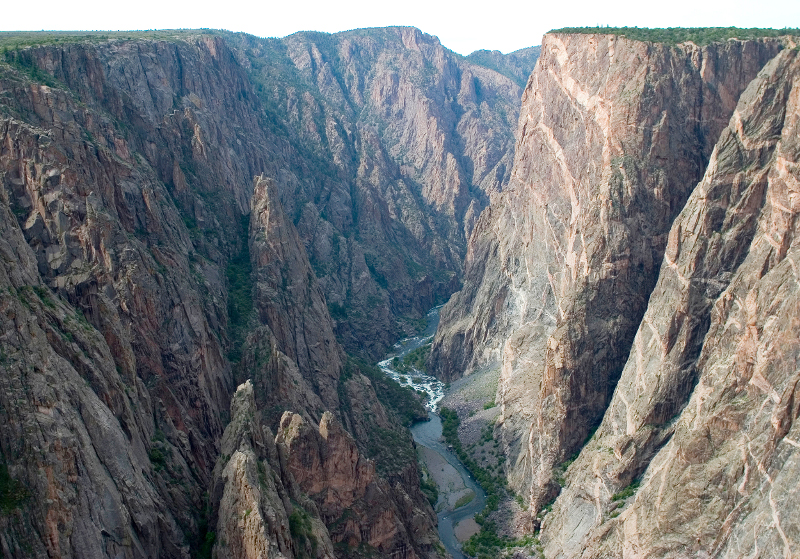


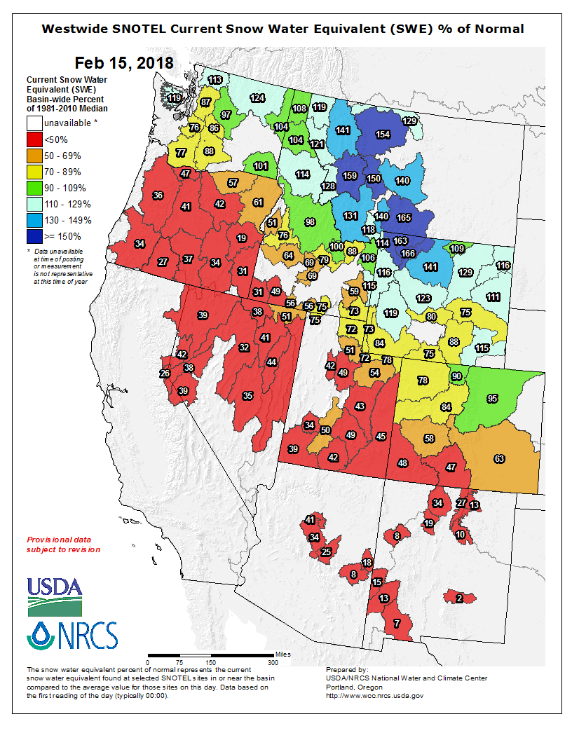
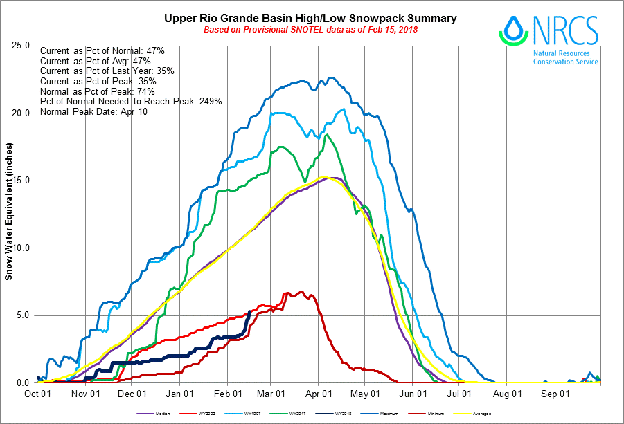
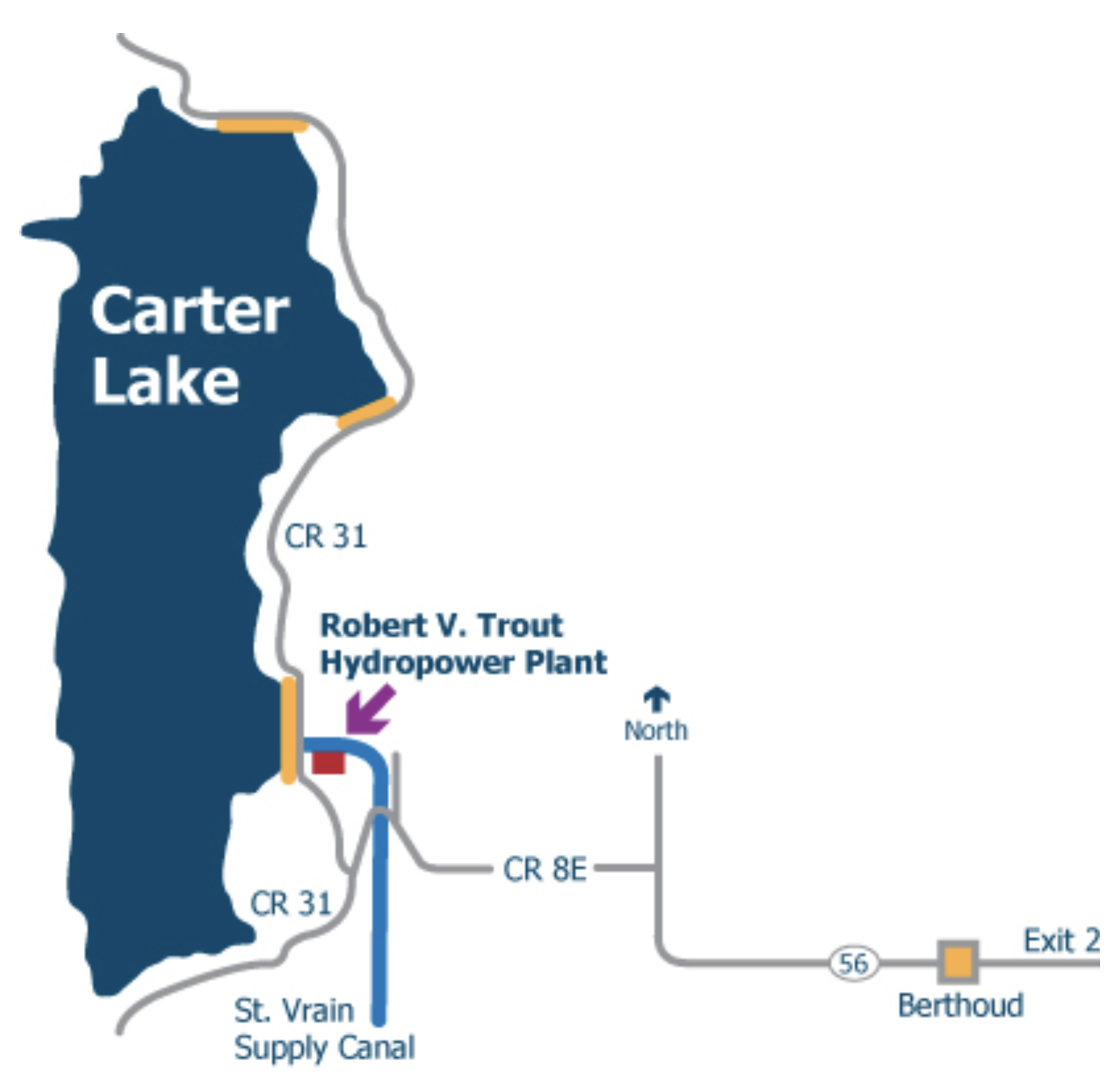
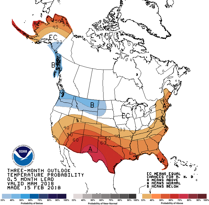
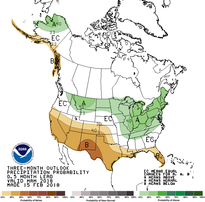
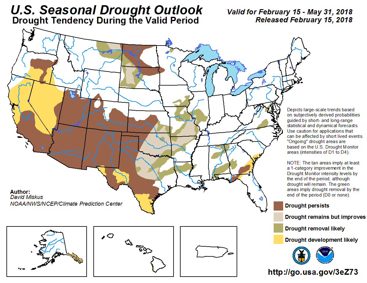


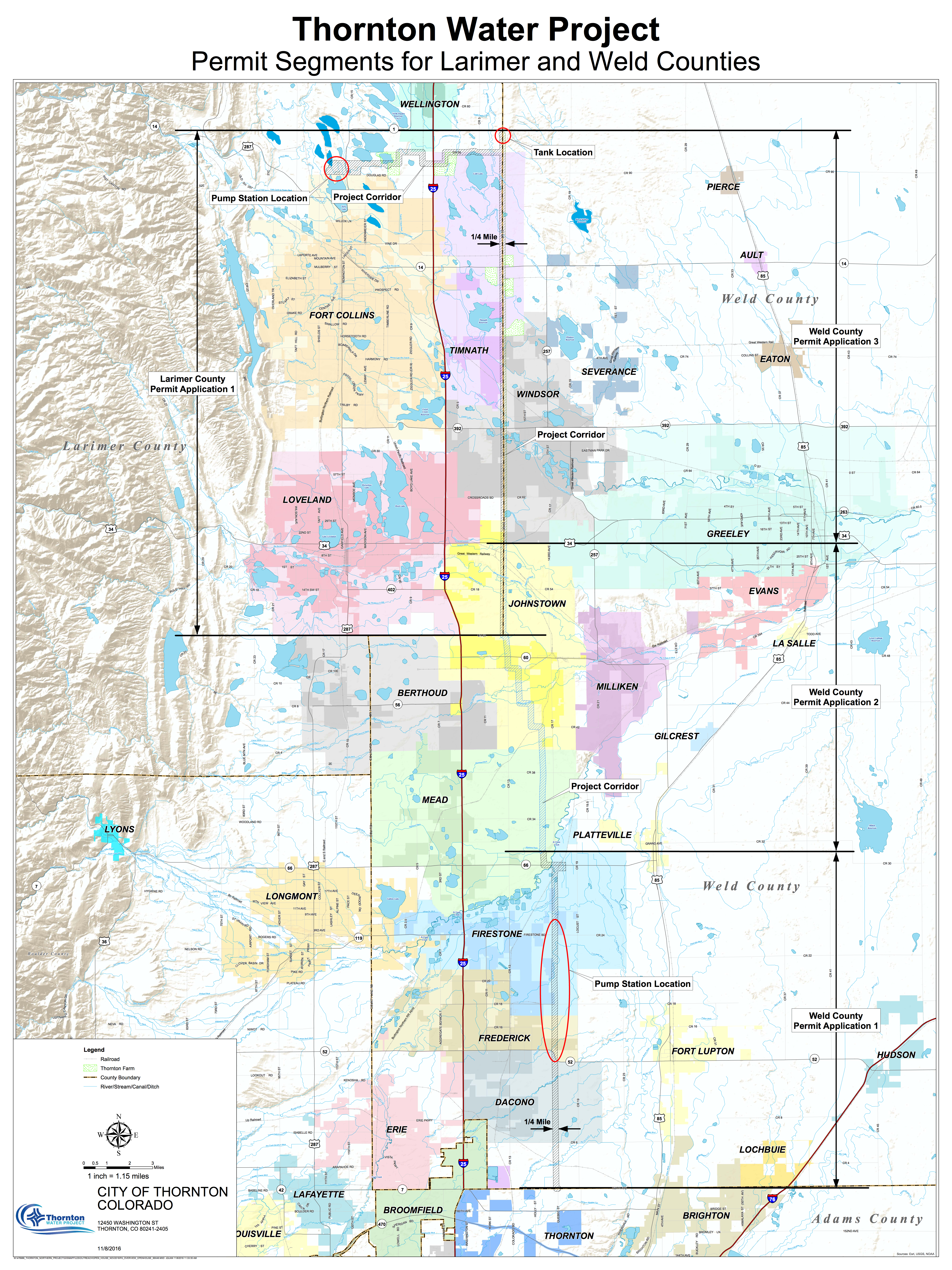

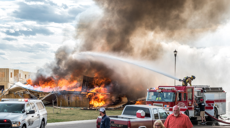


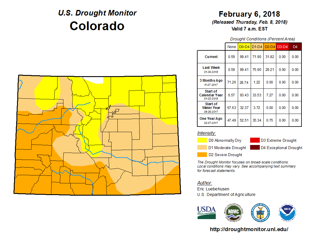

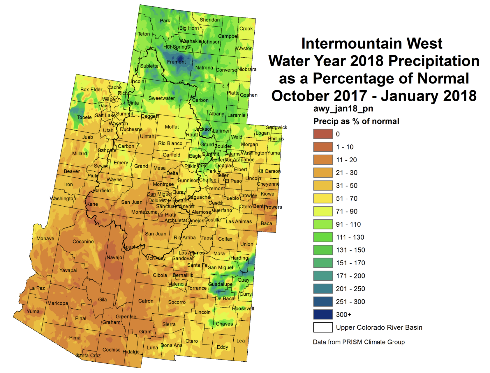


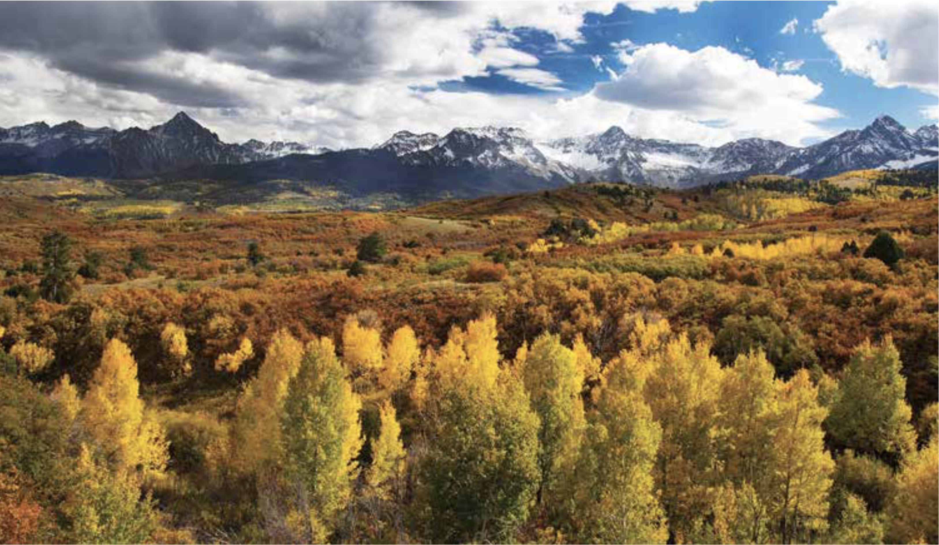
 January Average Temperature Departures
 January Percent of Average Precipitation