Sea shanties
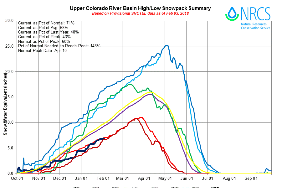
During January, the sea surface temperature in the Niño3.4 region of the tropical Pacific—our primary measurement for ENSO’s ocean component—was close to 1.0°C cooler than the long-term average. This places it comfortably in La Niña territory.
The November–January temperature in the Niño3.4 region was also 1.0°C cooler than the long-term average. Our double-dip La Niña’s second year has been stronger than the first, as the greatest departure from average during 2016–17 was -0.7°C. As Nat showed in his excellent post last week, this is somewhat unusual for a double-dip La Niña, as the second year tends to be a bit weaker than the first. However, as he discussed, the impacts on North American temperature and precipitation tend to be stronger in La Niña’s second year… if you haven’t read Nat’s post, go do it now! I’ll wait.
Carrying the tune
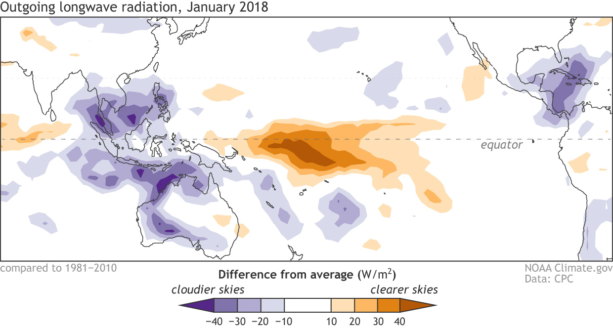
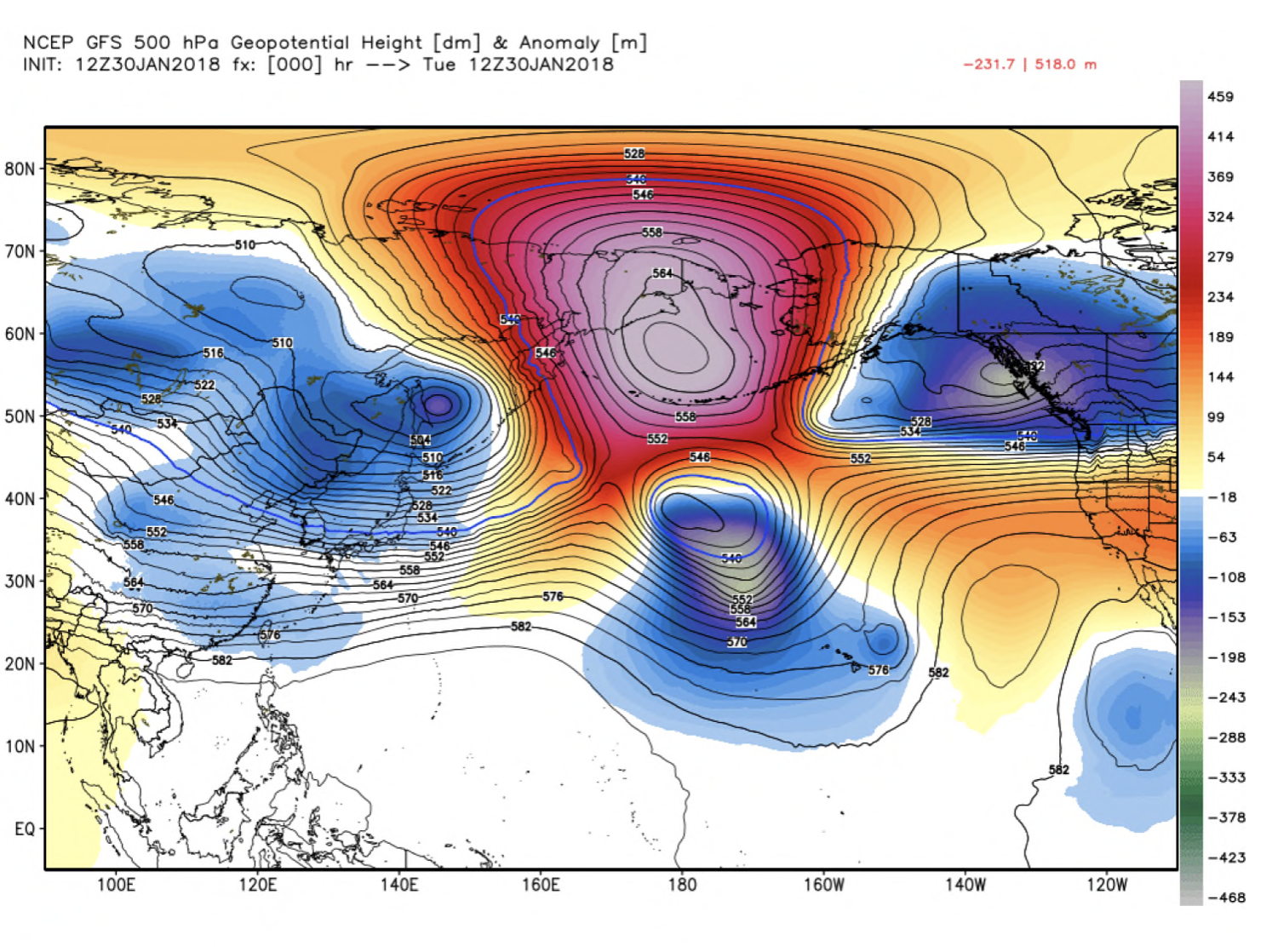
The atmosphere continues to respond to the cooler-than-average surface waters in the tropical Pacific, showing all the signs of a strengthened Walker Circulation. Those cooler-than-average waters lead to less rising air and cloud formation in the central Pacific than average, with more rising air and storms forming over the far western Pacific and Indonesia.
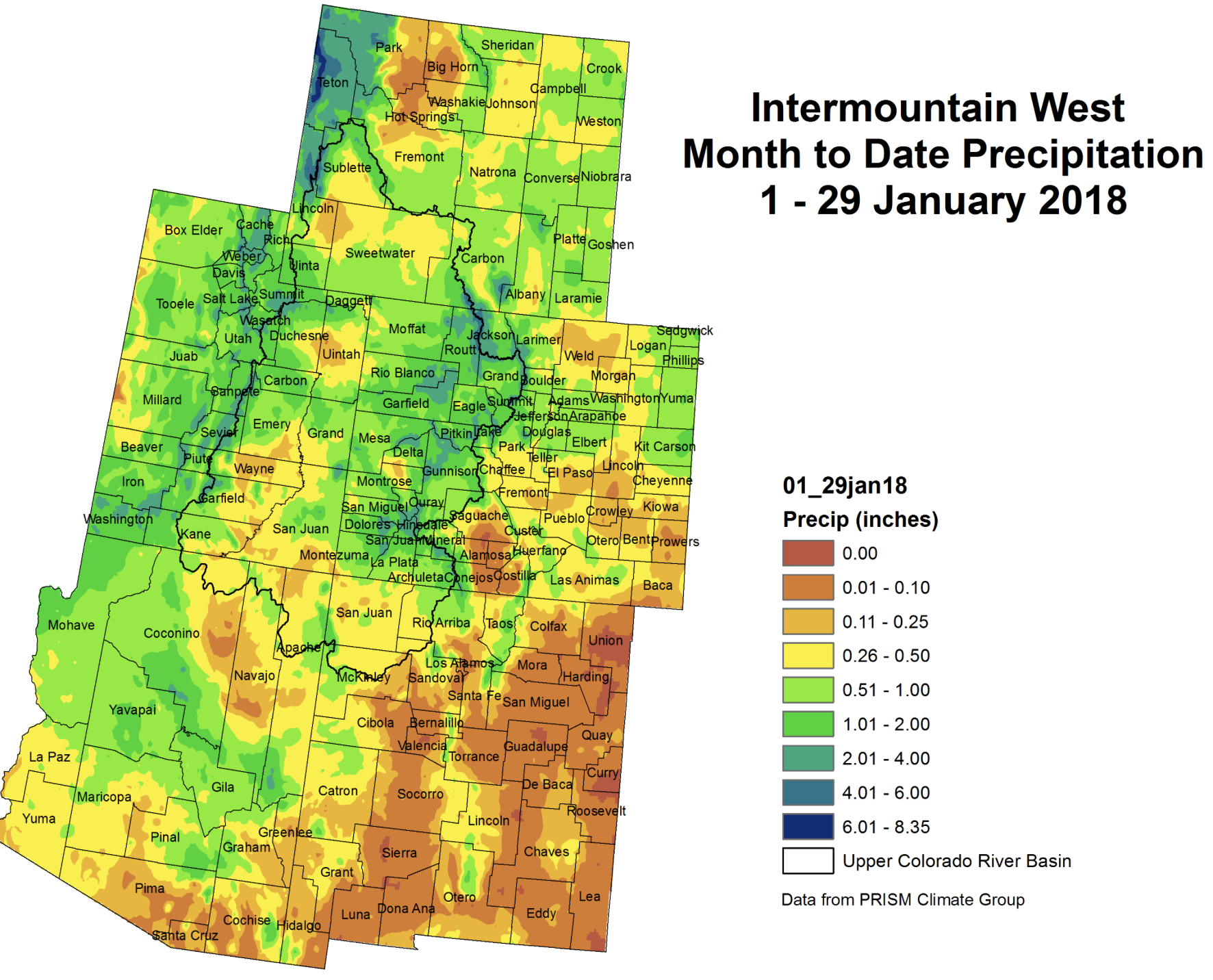
Places that were more (purple) or less (orange) cloudy than the 1981-2010 average during January 2018, based on satellite observations of outgoing longwave radiation (heat). Thick clouds block heat from radiating out to space, so less radiation equals more clouds, and more radiation equals clearer skies. Climate.gov map from CPC OLR data.
More evidence of the strengthened Walker Circulation during January was provided by stronger-than-average near-surface winds (the trade winds), as well as stronger west-to-east winds in the upper atmosphere. The stronger trade winds help to keep the surface cooler, and to keep warmer water piled up in the far western Pacific—part of the critical feedback processes that make up ENSO. However, this feedback doesn’t go on forever, and we’re seeing signs that La Niña’s swan song is imminent.
Bass notes
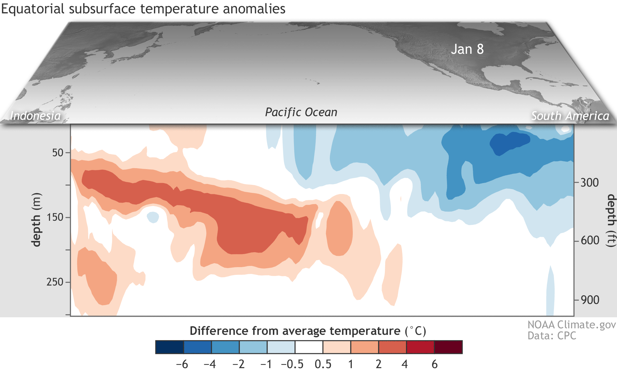
We keep track of what’s going on under the surface of the tropical Pacific, too, as significant temperature changes in the subsurface waters can provide a valuable clue about the evolution of ENSO events. From early December to late January, an area of warmer-than-average water centered between about 50 and 200 meters (~160–650 feet) under the surface traveled from the western Pacific to the east-central Pacific. This downwelling Kelvin wave chased away most of the cooler-than-average subsurface waters, leaving La Niña without it’s steady supply of cooler waters.
Departure from average of the surface and subsurface tropical Pacific sea temperature averaged over 5-day periods starting in early January 2018. The vertical axis is depth below the surface (meters) and the horizontal axis is longitude, from the western to eastern tropical Pacific. This cross-section is right along the equator. Climate.gov figure from CPC data.
This movement toward more neutral subsurface temperatures is one of the factors forecasters are looking at as we anticipate the decline of La Niña. Most of the computer models also foresee this transition, and overall forecasters have come to the consensus of a 55% chance that La Niña conditions will dissipate by March–May, as the tropical Pacific transitions to neutral conditions.
World music… or, a little off-key?
While this La Niña’s effect on precipitation and temperature has been generally in-line with expectations over North America, especially regarding the dry conditions across the southern half of the US, global impacts haven’t been entirely as expected during the past few months.
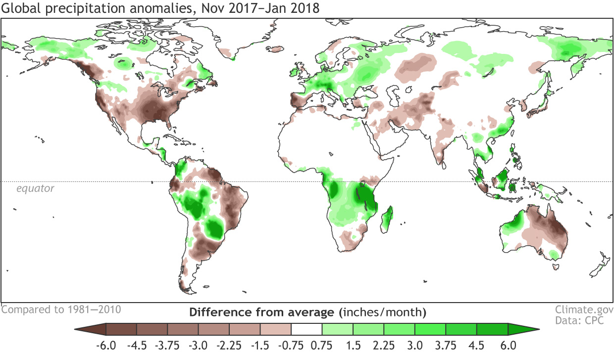
La Niña during November–January is associated with more rain than average in eastern Australia, northern South America, and southern Africa. On the other hand, La Niña ordinarily tends toward drier conditions in southern Brazil/northern Argentina/Uruguay, as well as southeastern China. (These maps show the expected patterns, but the colors are reversed, since they’re showing El Niño… sorry!) November 2017–January 2018, however, did not conform well to the expected patterns.
November 2017–January 2018 rain and snow patterns, shown as the difference from the long-term mean. Climate.gov figure from CPC data.
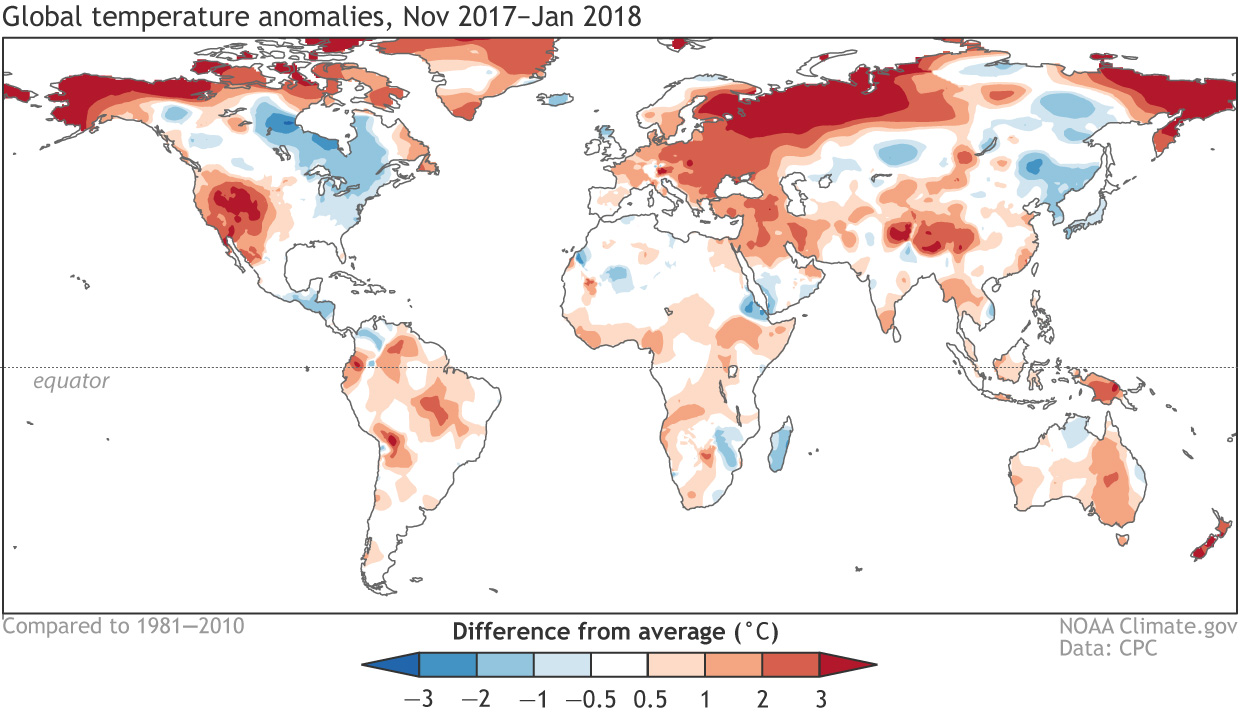
La Niña’s global effects on temperature have historically been associated with cooler temperatures in Australia, southern Africa, and much of South America, but, due to human-caused global warming, it’s increasingly rare to see a lot of cooler-than-average areas over the globe.
November 2017–January 2018 surface temperature patterns, shown as the difference from the long-term mean. Climate.gov figure from CPC data.
This doesn’t mean ENSO is useless as a forecasting tool, but it does further illustrate the complexity of the global climate system, and why forecasts are probabilistic. Over the past few months, La Niña just wasn’t the loudest voice in much of the world’s climate acapella group. (Check out Angel Munoz’s post about La Niña’s effects in South America for a much more effective musical analogy!)
Regarding other voices—stay tuned for Michelle’s later February post on the Madden-Julian Oscillation, who’s been outperforming himself over the past few weeks, likely affecting global weather and climate. Also, the MJO is currently substantially weakening the trade winds, potentially hastening La Niña’s curtain call. Don’t touch that dial! There’s more to come on Radio ENSO, after this message from our sponsors.
Last week, the U.S. Environmental Protection Agency (EPA) put a two-year suspension on the rule, also known as Waters of the United States (WOTUS), which protects large water bodies like lakes and rivers but also listed smaller waterways such as streams, ponds and wetlands for federal protection.
The decision to withdraw and replace WOTUS was advocated by industry groups like the American Farm Bureau Federation and the American Petroleum Institute, as well as Republican politicians and farmers, ranchers and real estate developers who viewed the rule as an infringement on property rights.
WOTUS was supposed to take effect in the coming weeks after the Supreme Court decided last month that cases regarding the matter should be heard by district courts. However, EPA administrator Scott Pruitt’s action halted the rule from implementation to come up with a more industry-friendly alternative.
But environmentalists say the suspension will allow uncontrolled pollution and destruction of our nation’s rivers, streams, lakes and wetlands.
New York Attorney General Eric Schneiderman is leading a coalition of 11 Democratic attorneys general from California, Connecticut, Maryland, Massachusetts, New Jersey, Oregon, Rhode Island, Vermont, Washington and the District of Columbia to block the move.
Click here to go to the US Drought Monitor website. Here’s an excerpt:
Summary
During the 7-day period (ending Tuesday morning), near- to above-normal precipitation was observed from the interior Southeast into New England, while dryness intensified across the southern half of the Plains and much of the southwestern quarter of the nation. Drought continued to expand on the southern Plans, while a reduction in drought intensity and coverage was noted in parts of the south and east where rain and snow were heaviest. The situation across the western U.S. presented sharply diverging scenarios, with good season-to-date moisture supplies across the northern Rockies and Pacific Northwest in sharp contrast to intensifying drought and a lack of vital snowpacks across central and southern portions of the Rockies and Sierra Nevada…
South
Rain in eastern portions of the region contrasted with intensifying drought across the southern Plans and environs. Rain totaled 1 to 3 inches (locally more) over central and eastern Mississippi, while two-week totals of 2 to 6 inches extended from southeastern Texas into central Mississippi. Despite the much-needed moisture, considerable longer-term deficits persisted in the Delta’s core Moderate and Severe Drought (D1 and D2) areas, with 90-day precipitation at or below 50 percent of normal (D2 equivalent or worse). Farther west, Extreme Drought (D3) expanded across much of northern Texas and western Oklahoma, with subsequent increases in D2 noted in central Texas and eastern Oklahoma. From Lubbock, Texas, northward into Oklahoma, little — if any — rain or snow has fallen over the past 90 days; the four-month Standardized Precipitation Index (SPI) was well below D4 levels (-2.0 or lower) in these locales. Despite the cooler season with minimal agricultural activity on the Plains, impacts were beginning to appear. In Oklahoma, the percent of winter wheat rated poor to very poor jumped from 10 percent at the end of November to 79 percent by the end of January, with 93 percent of the state’s topsoil moisture rated short to very short. In Texas, the lack of precipitation is reaching historic levels. According to the National Weather Service, February 7, 2018, marked the 117th consecutive day without measurable precipitation for Amarillo, shattering the previous mark of 75 days (records date back to 1892). In Lubbock, February 7 marked the 91st consecutive day without measurable precipitation, just 7 days shy of the 98-day benchmark. The situation on the southern Plains is rapidly becoming dire, and precipitation will be needed soon to prevent further expansion or intensification of drought…
High Plains
Additional snow in the north and west contrasted with increasingly dry conditions in southern and eastern portions of the region. A continuation of the recent unsettled weather pattern in northeastern Colorado (30-day surplus of 1-2 inches, liquid equivalent) supported the reduction of Moderate Drought (D1). Conversely, a lack of precipitation over the past 90 days coupled with input from experts in the field led to an expansion of D1 in northeastern South Dakota and southeastern North Dakota. Of particular concern is this winter’s subpar snowfall to date; winter snowfall is important for agriculture (providing runoff to refill stock ponds, protects winter wheat from temperature extremes, provides topsoil moisture) and serves as early spring water supply for ecosystems as the snowmelt season approaches…
West
Favorable conditions in the north contrasted sharply with dry, warm weather in central and southern portions of the region. From the Pacific Northwest into the northern Rockies, the favorable start to the current Water Year continued, with additional rain and mountain snow (1-4 inches liquid equivalent, locally more) reported during the 7-day period. As of Tuesday, February 6, the Snow Water Equivalent (SWE) of mountain snowpacks was well above normal (50-100th percentile) from Washington into the northern Rockies, with surpluses extending southward into the east-central Rockies (just west of Denver, Colorado). Conversely, the SWE was approaching or at historical lows (25th percentile or lower, with many stations reporting no snow at all) from western Colorado and much of Utah southward into Arizona and New Mexico. Likewise, the lack of snow — due in part to unseasonable warmth — has raised the specter of re-intensifying western drought in the Sierra Nevada, southern Cascades, and Blue Mountains. The lack of snow is having an immediate impact, forcing some ski areas to close historically early. Furthermore, a significant portion of the western water supply is contingent on snowmelt, and the poor spring runoff prospects will place a higher-than-normal burden on reservoirs. Currently, reservoir supplies are mostly in good shape due to last year’s abundant rain and snow. Nevertheless, the overall lack of precipitation since the beginning of the current Water Year (October 1) is compounding the effects of very low SWE, with season-to-date precipitation tallying a meager 25 percent of normal or less from southern California into the Four Corners region. In many of the aforementioned areas, drought will rapidly expand and intensify if precipitation does not return soon…
Looking Ahead
A wintry mix will depart the East Coast at the beginning of the period, with this system having already provided much-needed rain and snow to many drought areas of the southern and eastern U.S. On this storm’s heels, a frontal boundary initially draped over the northern Plains and Corn Belt will be the focus for another round of rain and snow. As the front pushes south, a wave of low pressure will develop and move northeastward across the Atlantic Coast States during the weekend. As a result, moderate to heavy precipitation (1-2 inches, locally more) will provide additional drought relief from the Delta into the Mid-Atlantic and Northeast, with lighter showers expected over the Southeast. Despite the active weather pattern, dry weather will linger from the southern Plains into the Southwest. The NWS 6- to 10-day outlook for February 13 – 17 calls for warmer- and wetter-than-normal weather across the eastern third of the nation. Likewise, near- to above-normal temperatures are anticipated from the Plains to the Pacific Coast — save for chilly weather on the northern Plains — but unfavorable dryness will persist from the western Corn Belt and central Plains to the Pacific Coast States.
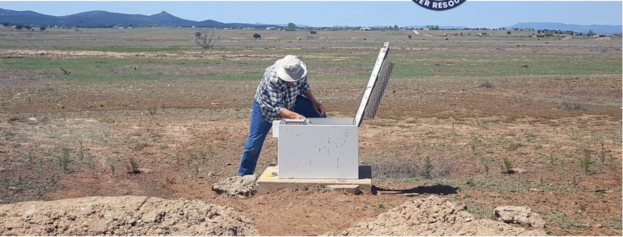
Martha Gomez-Sapiens, a monitoring team member and postdoctoral research associate in the UA Department of Geosciences, stands on a riverbank next to willows and cottonwoods that germinated as a result of the pulse flow. (Photo: Karl W. Flessa/UA Department of Geosciences)
Young girl enjoying the river restored temporarily by the pulse flow March 2014 via National Geographic
Photo via the National Geographic
Pulse flow tongue upstream of San Luis Rio Colorado. Photo credit: National Geographic
Landsat view of Colorado River pulse flow in Mexico April 2014
Colorado River pulse flow (Minute 319) reaches the Sea of Cortez for the first time since 1998 on May 15, 2014 via the Sonoran Institute
Point 24 in the Colorado River Delta, September 12, 2016. Photo credit The Nature Conservancy.
In 2014, the Colorado River did something it hadn’t done in decades. For a few short weeks that spring, the overdrawn, overallocated river reached the Pacific Ocean.
Instead of diverting the river’s last bit of water toward farm fields, the final dam on the Colorado River at the Mexican border lifted, and water inundated nearly 100 miles of the dry riverbed. It was called the pulse flow, meant to mimic a spring flood.
In 2010, an earthquake in northern Mexico set in motion a big change in how people think about the lowest reaches of the Colorado River. The quake destroyed irrigation canals, leaving farmers unable to use all of their water. As the result of an emergency agreement, Mexico began storing its share in U.S. reservoirs. After another international agreement, Mexican and American officials decided that, as an experiment, the surplus water should temporarily flow into the river’s driest reaches.
The water’s life-giving effects spilled beyond the river’s banks. Kids who’d never seen it in its natural channel, splashed and played. Spontaneous festivals came to life. Birds returned, and trees and marshes greened up.
But the moment was fleeting. Within a few months, the majority of the delta was dry once again.
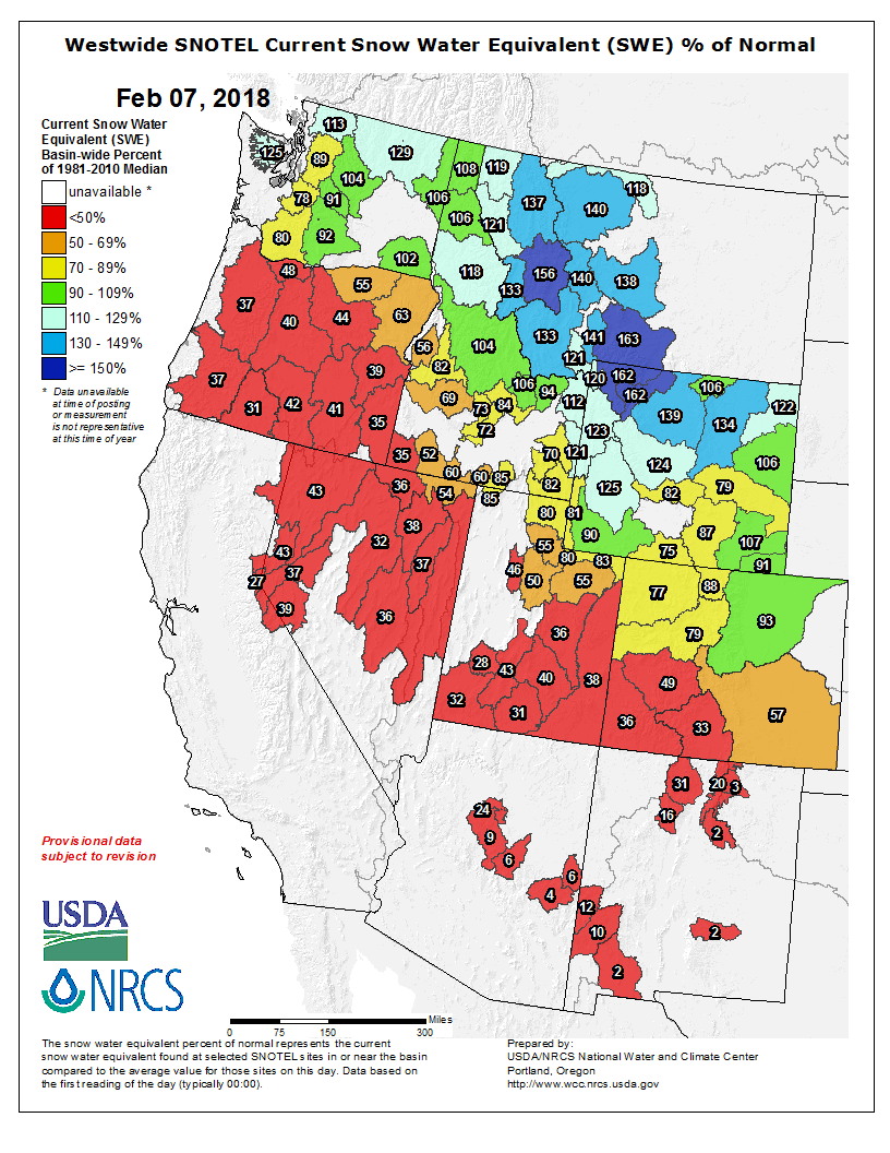
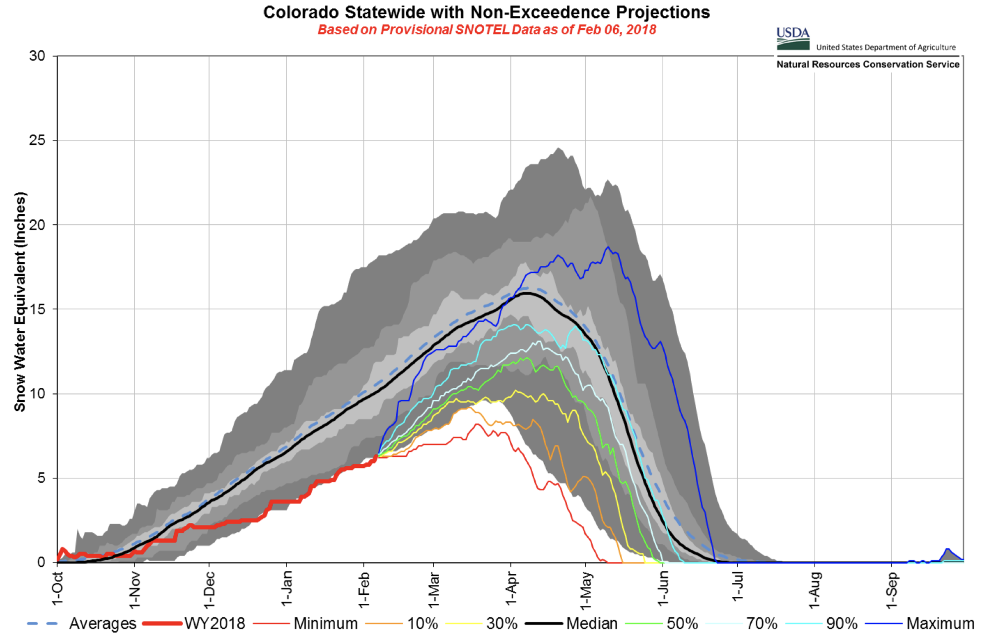
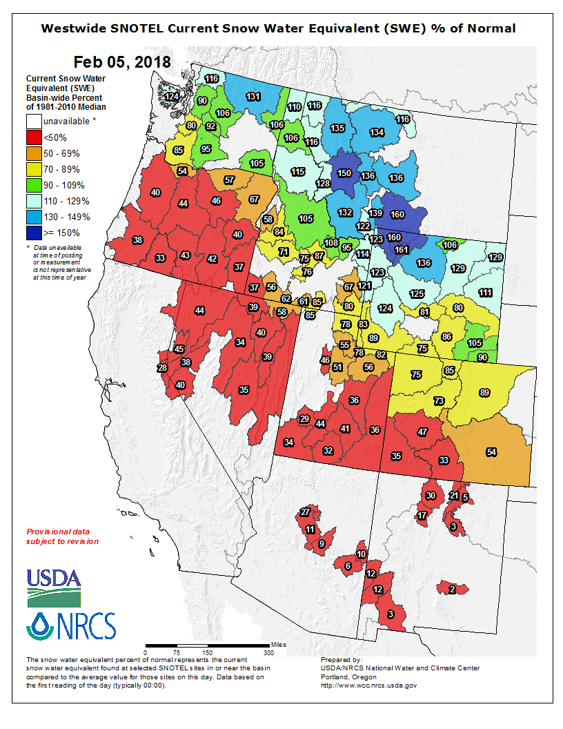
Westwide SNOTEL basin-filled map February 7, 2018 via the NRCS.
FromThe Grand Junction Daily Sentinel (Dennis Webb):
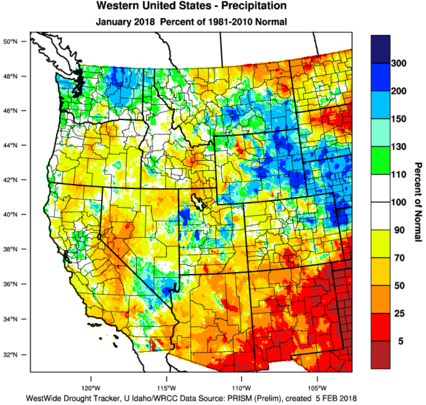
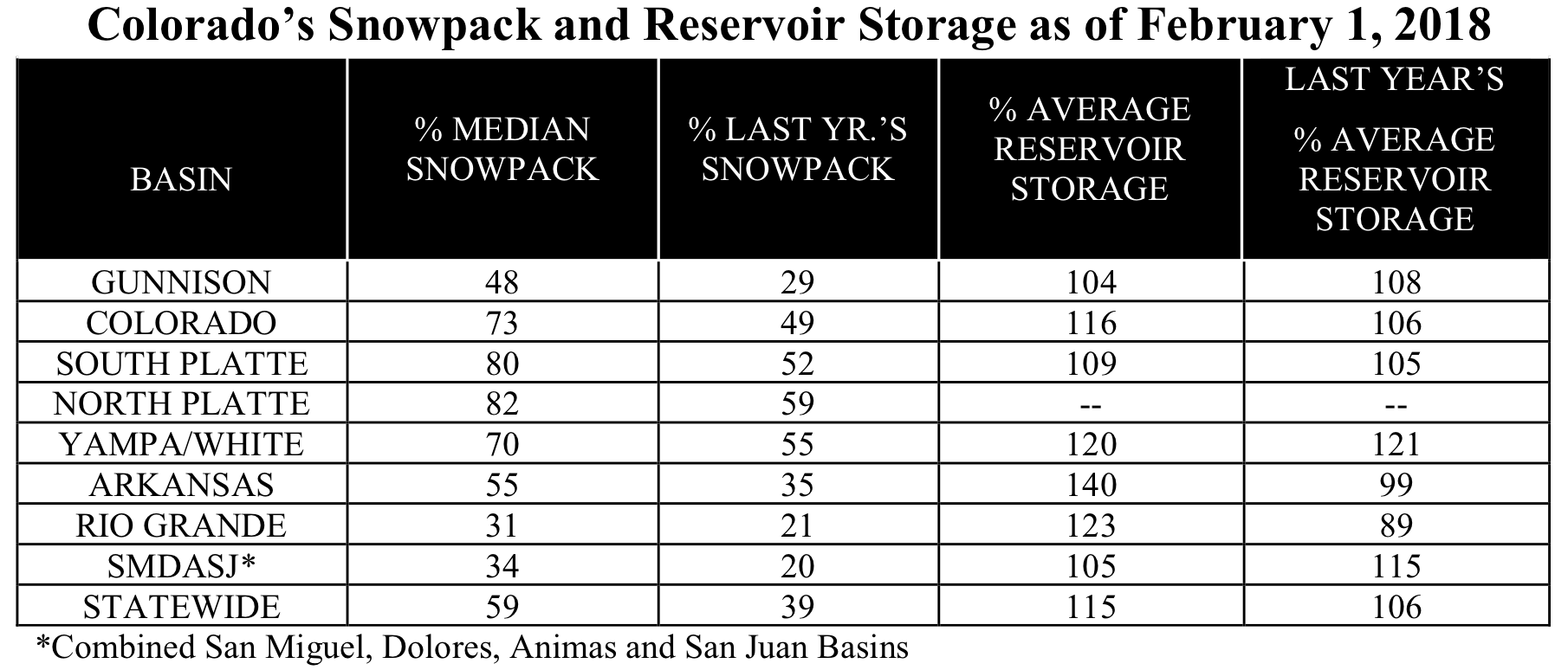
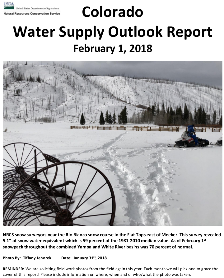
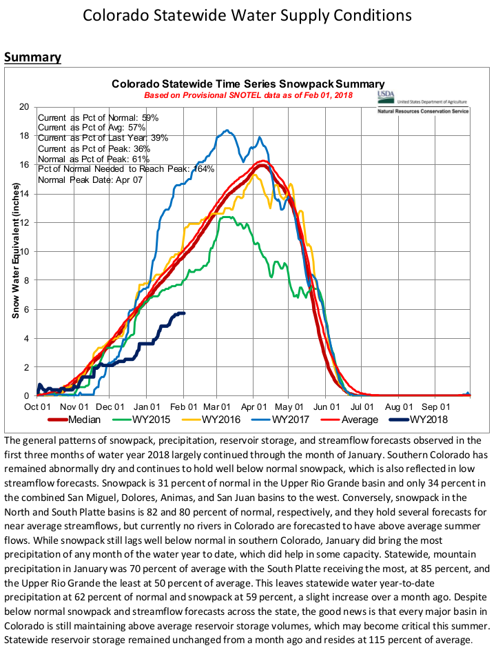
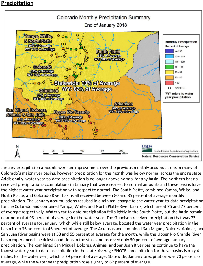
January was wetter than previous months in Colorado’s mountains, but still saw precipitation that was just 70 percent of average, which pretty much sums up the atrocious state of affairs when it comes to current snowpack levels.
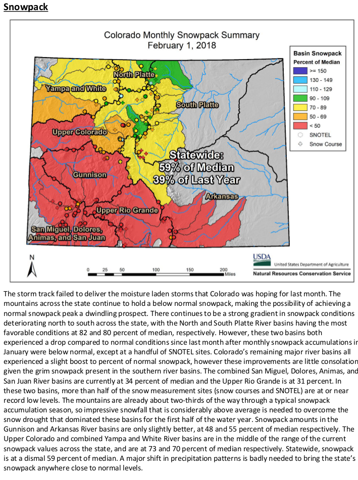
Statewide snowpack was at 64 percent of median Wednesday, according to Natural Resources Conservation Service data.
That’s up from 54 percent of normal Jan. 1, but the wetter January “can hardly be viewed as a reprieve from the tenacious pattern of dry weather,” the NRCS said in a news release Wednesday…
Brian Domonkos, Colorado snow survey supervisor for NRCS, said in the release, “Nearly one-quarter of the almost 200 snow monitoring sites across our network recorded snowpack at the lowest or second-lowest levels on record.”
Current snowpack levels range from 93 percent of median in the South Platte River Basin to just 33 percent in the Upper Rio Grande Basin. The Upper Colorado Basin is at 79 percent of median, and the Gunnison Basin is at just 49 percent, reflecting the sharp divide in moisture levels between northern and southern Colorado thanks to a La Niña weather pattern that typically brings more snow to the northern part of the state.
Domonkos said areas such as Wolf Creek Pass and Red Mountain Pass in the San Juan Mountains currently have just two or three feet of snow, compared to a typical five to six feet of snow in early February.
“What’s more concerning is the considerable number of mid- to lower-elevation monitoring sites that have little to no snow,” he said.
Some streams in the Upper Colorado and South Platte basins are forecast to have near-average streamflows this summer, but the Gunnison Basin forecasts range from 72 percent of average for the Slate River near Crested Butte to 27 percent for Surface Creek at Cedaredge.
The current streamflow forecast for the Plateau Creek drainage is 39 percent of average, another reflection of poor snowpack levels in the Grand Mesa area. Powderhorn Mountain Resort on Grand Mesa recently announced it was returning to a reduced, Thursday through Sunday operating schedule to help preserve snowpack higher on the mountain as the drought continues…
A saving grace for the state’s water outlook in coming months is reservoir storage, which the NRCS says is at the highest January level in many years, at 115 percent of normal. Gunnison Basin storage is at 104 percent of normal, and Colorado River Basin storage is at 116 percent.
As of Feb. 1, the Colorado Basin River Forecast Center was projecting that inflows into Lake Powell will be 47 percent of average during the runoff season. The reservoir, viewed by Colorado and other states in the Upper Colorado River Basin as their bank account for meeting downstream water-delivery obligations, is 56 percent full.
Snowpack for the two basins that provide water to northern Colorado — the upper Colorado and South Platte River basins — still are cause for concern, despite the fact they are in a better spot than other basins around the state, said Brian Werner of Northern Colorado Water Conservancy District.
As of Wednesday, the upper Colorado was 79 percent of average while the South Platte was 93 percent of average. Statewide, snowpack is at 64 percent of average, now halfway through the season.
“Our biggest water-related months are March and April,” Werner said. “That’s where we get the wet, heavy spring snows that provide a lot of water to us. Our biggest months are still ahead of us.”
According to the U.S. Department of Agriculture, January’s statewide snowpack measured at 69 percent; that sank 5 percentage points by Wednesday. For January, a quarter of the state’s 200 snow monitoring sites across the state showed the lowest or second lowest levels on record, Brian Domonkos, Colorado Snow Survey supervisor, reported in a news release…
Northern Water on Wednesday had just conducted its first streamflow forecast for the year, as well. Based on that check, officials forecast that runoff — the amount of water that will flow through the rivers into local water supplies — will be at 80 percent to 90 percent of average come May and June. But that number can change every month.
The rest of the state may not be so lucky.
“While some streamflow forecasts in the South Platte and Upper Colorado River basins are projected to produce runoff within the range of normal, far more rivers and streams throughout the rest of Colorado are forecasted to provide below normal to well below normal runoff this spring,” the release stated.
Northern Colorado’s water supply is especially important to the agriculture industry throughout Weld County. The season has been dry and windy, and cause for concern. Soil moisture conditions were threatened due to a dry November, December and January, as well as heavy winds that tended to dry out the soil.
“That’s a concern with farmers, so some of the wet snows ahead could help us,” Werner said.
FromThe Denver Post (Bruce Finley) via The Loveland Reporter-Herald:
In southern Colorado river basins, the federal data through Feb. 7 showed snowpack in the Rio Grande River basin measured 33 percent of normal. In the combined San Miguel, Dolores, Animas and San Juan River basins, snowpack measured 35 percent of normal.
Northern Colorado fared wetter. Survey crews measured snow depths in the South Platte River basin that serves as a main source for metro Denver and northeastern farm fields at 93 percent of normal, and in the North Platte River basin at 88 percent of normal. The snowpack in the upper Colorado River basin that also is a key source of water for booming Front Range cities measured 79 percent of normal.
At this point with traditional winter passing, recovery to near-normal snowpack would require a major shift in ocean-driven weather patterns.
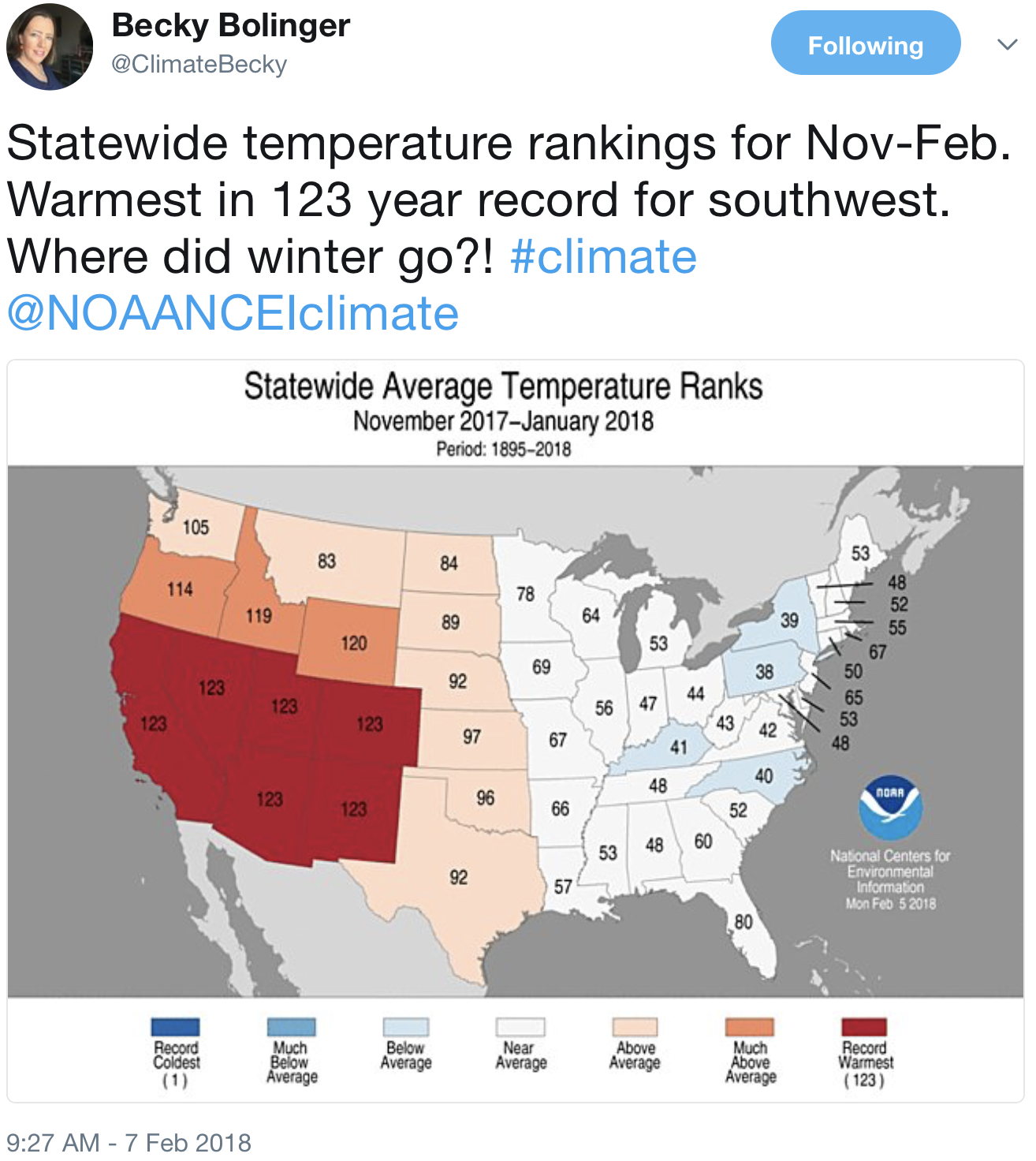
Temperatures also play a role. On Wednesday, the National Oceanic and Atmospheric Administration issued a bulletin noting that the average U.S. temperature in January was 2.1 degrees higher than the 20th Century average. Colorado ranked among nine western states where temperatures in January were much warmer than average.
The low mountain snowpack means water flows in streams this spring likely will fall far below normal.
However, Denver Water officials who supply water to 1.4 million people, said recent storms in mountains above its reservoirs brought snowpack at those locations to normal or better for this time of year.
“Denver Water is cautiously optimistic regarding snowpack,” spokeswoman Stacy Chesney said. “The next few months will determine the water available to us during spring runoff. It’s still too early to speculate on snow totals for the year because we often see good snow accumulation in March and April.”
Northern Water officials echoed that assessment.
“Obviously, we would rather be above average heading into February,” Northern Water spokesman Brian Werner said. “However, our two biggest water-producing snowpack months are ahead of us in March and April. The next three months will prove critical. We’ve seen years turn around completely in the spring with those good, heavy, wet snows that add to water supplies once they melt.
“Is there concern? Yes, especially for those in southwestern Colorado where the numbers are much worse,” he said. We like to see snow everywhere in the mountains this time of year.”
A few years ago when mountain snow stayed at record-low levels in California and Nevada, water shortages and droughts hit hard. California officials ordered urban water use restrictions. Here in Colorado, state officials leave water supply planning and drought response largely to the discretion of local governments and utilities.
The Colorado Basin River Forecast Center’s water supply forecast map shows several river basins projected to be below average during the spring runoff season. Credit Colorado Basin River Forecast Center / National Oceanic and Atmospheric Administration
Hydrologist Greg Smith of the National Oceanic and Atmospheric Administration said Wednesday Lake Powell is expected to get 47 percent of its average inflow because of scant snow in the mountains that feed the Colorado River.
Smith says there’s only a 10 percent chance that enough mountain snow will fall during the rest of the winter to bring inflows back to average.
If you drive over Red Mountain Pass near Silverton, Colorado, north of Durango this weekend, you’ll see lots of snow, like every winter. But you’ll also see rocks and trees poking through the snow that you don’t normally see this time of year.
Those rocks and trees symbolize Rocky Mountain snowpack stuck at record-tying low levels for midwinter. These levels spell potential trouble for the spring-summer runoff that supplies much of Tucson and Phoenix’s drinking water, both for now and for the future.
The Upper Colorado River Basin snowpack in places like Red Mountain Pass, elevation 11,500 feet, feeds the river’s tributaries that drain into the main Colorado River, which supplies the Central Arizona Project serving Tucson, Phoenix and Pinal County cities and farmers.
Normally by now, Red Mountain Pass has had 12 winter snowstorms, said Jeff Derry, director of the nonprofit Center for Snow and Avalanche Studies in Silverton. This winter, it’s had four. Farther north, 2 feet of snow are piled in the mountain passes near Glenwood Springs in western Colorado, compared with 6 to 8 feet a year ago.
Overall, the Upper Basin’s snowpack recently has ranged from 63 to 65 percent of normal, says the federal Colorado River Basin Forecast Center. That ties with 1990 for the lowest snowpack on record for this time of year, the forecast center says.
The center predicts that April-July runoff into Lake Powell will be 47 percent of normal. That doesn’t make a CAP shortage likely next year. As of now, the federal government says the chance of such a shortage is only 17 percent for 2019.
But the risk rises to 49 percent in 2020, 58 percent in 2021 and 63 percent in 2022, say current U.S. Bureau of Reclamation forecasts based on computer models.
And Tom Buschatzke, director of the Arizona Department of Water Resources, is concerned that under the worst case scenario, Lake Mead could dip a half-foot below 1,075 feet by the end of 2018 and drop an additional 4.5 feet by 2020. A shortage is supposed to be declared if the lake drops below 1,075 feet, although he says additional water conservation could probably prevent that.
Arizona and the rest of the river basin have been through such worries before and came through unscathed. In winter and spring 2015, snowpack levels and runoff forecasts were grim through April. Authorities in Arizona were gearing up for the first-ever cutback in CAP deliveries in the following year.
Instead, Colorado was pounded by record rainfall the next month, which has since been dubbed “Miracle May,” and no 2016 shortage occurred.
Today’s long-range forecasts for the Colorado Basin don’t see miracles ahead. They predict a dry spring in areas of the Upper Basin south of Interstate 70, which covers the majority of Colorado and a good part of Utah.
There’s no way to predict a Miracle May because it didn’t happen in 2015 “until it was right on top of you,” said Eric Kuhn, retired general manager of the Colorado River District that manages water in western Colorado.
The immediate cause of this low snowpack is a combination of two extremely strong weather systems hanging over the region since November that have refused to move.
First, an Arctic-spawned low-pressure system — which Arizona water officials have dubbed “the Blob” — is centered over Canada’s Hudson Bay. It has held temperatures well below normal for much of the winter across the eastern and midwestern U.S.
Below that is a high-pressure system hanging over the eastern Pacific and the Southwest that has driven the jet stream northward and left much of the West warm and dry, including not only the Colorado River Basin but the Sierra Nevada Mountains in California.
“We unfortunately are dominated by this high-pressure ridge over the West, and it works in tandem with the really strong low pressure ridge to the east,” said Greg Smith, a hydrologist for the Colorado River Basin Forecast Center. “When these features are very strong, they can be persistent. These features have been persistent over much of the winter.”
Another potential, and probably likely factor, is climate change.
Studies have shown significant snowpack declines across most of the western U.S. since the 1950s, the Environmental Protection Agency has said. Human factors, including climate change, ozone depletion and land use, accounted for 20 percent of the loss in annual Western mountain snowpack since the 1980s, said an April 2017 study from Lawrence Livermore National Laboratory in Berkeley, California.
Peak runoff in streams and rivers of the West is strongly influenced by melting of accumulated mountain snowpack.
Based on the current state of the snowpack, the researchers predict a further loss of up to 60 percent within the next 30 years.
“The projected losses have serious implications for the hydropower, municipal and agricultural sectors in the region,” said John Fyfe, a research scientist for Environment and Climate Change Canada, and lead author of the study, published in the journal Nature Communications.
Brad Udall, a prominent Colorado State University water researcher, acknowledged there’s no way to be certain without additional study that this year’s poor snowpack is directly related to climate change caused by greenhouse-gas emissions.
But many of the weather patterns that are linked with this year’s poor snowpack “look like our future,” based on what other researchers have predicted will happen because of climate change, Udall said.
First, this year saw a late start to winter weather across the entire river basin and in California, he said.
Second, record-warm Colorado weather from October through December meant that a lot of snowpack evaporated and became water vapor instead of becoming stream runoff. Finally, this winter’s pattern of extremely dry weather south of Interstate 70 and the less dry weather north of I-70, is also what climate models have predicted, Udall said.
Over the past 18 years ending in 2017, only four years saw even average runoff down the Colorado, Udall said.
“That’s less than half of the big flow years on average that we used to get,” he said.
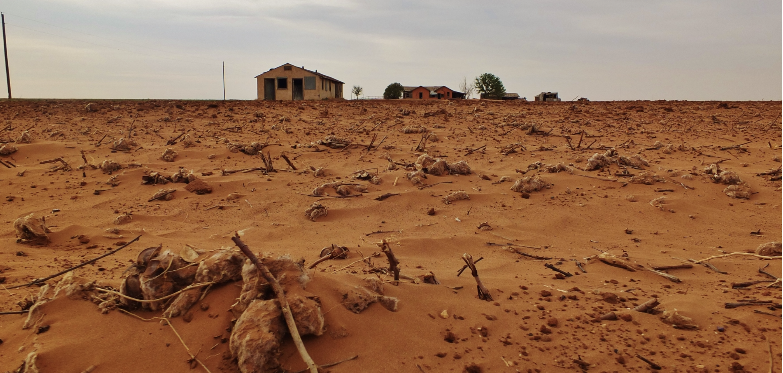
After more than three years of severe drought, Cape Town, a city of nearly 4 million people, is running out of water. “Day Zero”—the day city officials estimate the water system will be unable to provide drinking water for the taps—is less than three months away, and substantial rains are not expected before then.
In response, city managers have imposed a series of increasingly severe water-use restrictions to cut demand and are working to find emergency sources of supply, but it is difficult to see how a cutoff can be avoided. People will not die of thirst: Emergency water will be brought in for basic needs. But the social, economic, and political disruptions caused by a water cutoff will be unprecedented.
Cape Town is not alone. California, São Paulo, Australia, the eastern Mediterranean, and other regions have all recently suffered through severe droughts and water crises.
Short-term droughts and water shortages aren’t new. Under normal circumstances, cities can respond by temporarily cutting water waste. But circumstances aren’t normal anymore. More and more major cities will face their own Day Zero unless we fundamentally change the way water is managed and used.
The growing water crisis is the result of three factors. First, more and more regions of the world are reaching “peak water” limits, where all accessible, renewable water has been spoken for and no traditional new supplies are available. Second, urban populations and economies are expanding rapidly, putting additional pressures on limited water supplies and increasing competition with agricultural water users. And third, the very climate of the planet is changing because of human activities such as burning fossil fuels, affecting all aspects of our water systems, including the demand for water and the frequency and intensity of extreme events like floods and droughts.
Where these three factors combine, urban water crises explode.
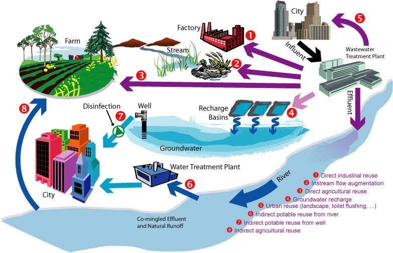
The good news is that there are two key solutions to making our cities more resilient to water crises and disruptions: Reduce water demand and find new non-traditional sources of water supply.
Reducing demand means improving the efficiency of water use and changing water-using behaviors to reduce immediate needs. The first option includes installing efficient irrigation technology, replacing inefficient toilets, showerheads, washing machines, and dishwashers, and eliminating leaks. The second option includes cutting outdoor landscape water use and replacing water-intensive gardens, taking shorter showers, flushing toilets less often, and eliminating luxury water uses like private swimming pools.
The potential for these two approaches to reduce demand is enormous. During the severe drought in Australia from 2000 to 2009, urban water efficiency measures saved more water at lower cost and greater speed than traditional supply options, like tapping rivers and groundwater. During the drought, water demand dropped 60% in South East Queensland through a combination of investments in water efficiency programs and restrictions on outdoor water use. California urban water use was cut by over 25% during the 2012-2016 drought through similar indoor and outdoor efficiency programs, and there is much potential for even greater savings.
There are new supply options available too, even in regions where traditional sources are tapped out. South Africa has long pioneered the restoration of watersheds by removing invasive species like blue gum, wattles, and the vine kudzu, and increasing water flows in rivers. Artificially enhancing groundwater replenishment can increase the storage of water far more effectively than building new surface reservoirs. Wastewater treatment and reuse turns what used to be considered a liability into a valuable resource.
Cape Town currently only treats and reuses 5% of its wastewater—up until now they haven’t thought they had the need—and could greatly expand treatment and reuse. Just next door to South Africa in Namibia, the city of Windhoek has been reusing treated wastewater for decades. About 40% of Singapore’s total water demand is now being met with high-quality treated wastewater. California currently reuses about 15% of its wastewater and has the potential to greatly expand reuse in coming years. And when less costly options have been exhausted, seawater desalination offers a way to provide drought-proof supply.
It will rain again in Cape Town, and the emergency responses implemented over the next few months will be relaxed. But water problems are not going to disappear until we consistently and comprehensively change the way we think about and manage water. Peak water limits will be felt in more and more regions as traditional sources of water are tapped out. Urban areas will continue to expand. Global climate changes will accelerate and worsen, especially if we delay the transition to clean energy. The sooner we accept these facts, the sooner every city can move to manage water in a more sustainable fashion, postponing or even eliminating the risk of their own Day Zero.
If we are adequately to talk about the weather this century, we are going to need a new lexicon that better captures the current reality, writes Tom Philp of Metropolitan Water District.
Water policy is becoming a prisoner of its own limited vocabulary, particularly when it comes to the weather. Here is a case that “drought” and “normal” belong in the dustbin of history, for their overuse can lead to the wrong conversation. These words are not so sinister as to be banned from the dictionary. But they tend to miss the mark as to what seems to be happening with our weather this century.
First, the case against “drought.”
In California, a drought only happens when a governor declares it to be so. It is invariably announced via an executive order when the state is already well into a publicized dry pattern. Likewise, Sacramento declares the drought over after it has been raining like mad.
Yes, dry years strung together are important. They have their acute set of management problems. The recent multi-year dryness brought true hardship to many communities, farmers and aquatic ecosystems throughout the state. Longer streaks may lie ahead.
But looking back at California’s weather so far this century, we have been “dry” (as in below-average precipitation) two years out of three. Sometimes they have come in streaks that draw temporary attention. Sometimes they have been sandwiched in between by a single wet year.
Being dry two years out of three is a very big deal. For lack of a better term, it is like a Semi Drought. A Dry Period. This needs a name. This has some very serious consequences.
There is evidence throughout the West that groundwater basins have suffered because of this chronic semi-drought. The University of Arizona recently documented the emerging problems of the Semi Drought.
And Southern California, even with intensive groundwater management, has not been immune from the impacts. Based on information collected by the Metropolitan Water District of Southern California, local groundwater production has decreased by more than 200,000 acre-feet since 2000. The net loss is roughly equivalent to the annual residential needs of the cities of San Diego, Burbank, Anaheim, Long Beach, Glendale and Garden Grove.
No governor has ever declared California to be in a chronic Semi-Drought. Perhaps this weather trend is rarely discussed, and never declared, because we haven’t settled on a catchy word that describes what has steadily emerged to be our most challenging long-term weather problem.
Second, the case against “normal.”
Yes, normalcy has an unavoidable mathematical purpose. There must be a benchmark for a past to describe the present. But there really is not such a thing as normal, or average, in the state that has had the most variable weather in the country. And the experts seem to be telling us that things will be even less “normal” in the future.
Cases in point are two studies that came out of the Scripps Institution of Oceanography at the University of California-San Diego last fall. They pointed to even more volatility, as in dramatic swings from wet to dry years (sound familiar?) in the future.
“Rainfall in a warmer future will be delivered in less frequent but more intense events,” Scripps meteorologist Alexander Gershunov said at the time.
As Gershunov intimated, the Scripps research also pointed to more frequent dry years in the future. That is more evidence that the Semi Drought that is under way is truly the norm.
Meanwhile, we all watch the weather. We all wonder what about the future. And we converse about it in yesteryear’s language.
If we truly are in a long and challenging Semi-Drought, or whatever we end up calling it, whether it is very wet or very dry or very “average” in any given year is important in the short term. But in the long term, it is a statistical asterisk.
Here’s the release from the NRCS (Brian Domonkos):
In the mountains of Colorado, January proved to yield the best precipitation so far this water year, but it can hardly be viewed as a reprieve from the tenacious pattern of dry weather. At 70 percent of average, January precipitation was only slightly better than October at 69 percent. Snowpack too saw minimal improvement across the state up from 54 percent of normal last month to now 59 percent of normal on the first of February. “Nearly one quarter of the almost 200 snow monitoring sites across our network recorded snowpack at the lowest or second lowest levels on record,” said Brian Domonkos, Colorado Snow Survey Supervisor, referring to the network of USDA Natural Resources Conservations Service SNOw TELemetry and Snow Course sites nestled in the mountains of Colorado. With nearly one third of the typical winter season remaining, a major shift in weather patterns will be needed to make significant improvements, particularly in Southern Colorado.
Highlighting the below normal conditions, SNOTEL sites within the Rio Grande basin indicate snowpack is the lowest in recent history at 31 percent of normal. Meanwhile the SNOTEL sites in the combined San Miguel, Dolores, Animas and San Juan River basins observe the lowest standing year-to- date precipitation at 29 percent of normal. Northern Colorado however is performing considerably better. On the high side, snowpack in the North Platte River basin is at 82 percent of normal and in the South Platte River basin, which is home to much of the Denver Metro area, snowpack is at 80 percent of normal and year-to-date precipitation is much closer to normal at 98 percent.
Areas of Colorado such as Wolf Creek Pass and Red Mountain Pass in the San Juan Mountains typically boast five to six feet of snow in early February, but currently report only two to three feet. Domonkos adds, “What’s more concerning is the considerable number of mid to lower elevation monitoring sites that have little to no snow.” Most of these sites are located in the southern half of the Colorado.
Reservoir storage across the state is at the highest January levels in many years, at 115 percent of normal and will provide some assistance to spring and summer runoff where snowpack is well below normal. While some streamflow forecasts in the South Platte and Upper Colorado River basins are projected to produce runoff within the range of normal, far more rivers and streams throughout the rest of Colorado are forecasted to provide below normal to well below normal runoff this spring. For more specific streamflow forecast values refer to the Colorado Water Supply Outlook Report.
For more detailed and the most up to date information about Colorado snowpack and supporting water supply related information, refer to the Colorado Snow Survey website at: http://www.nrcs.usda.gov/wps/portal/nrcs/main/co/snow/
Or contact Brian Domonkos – Brian.Domonkos@co.usda.gov – 720-544-2852
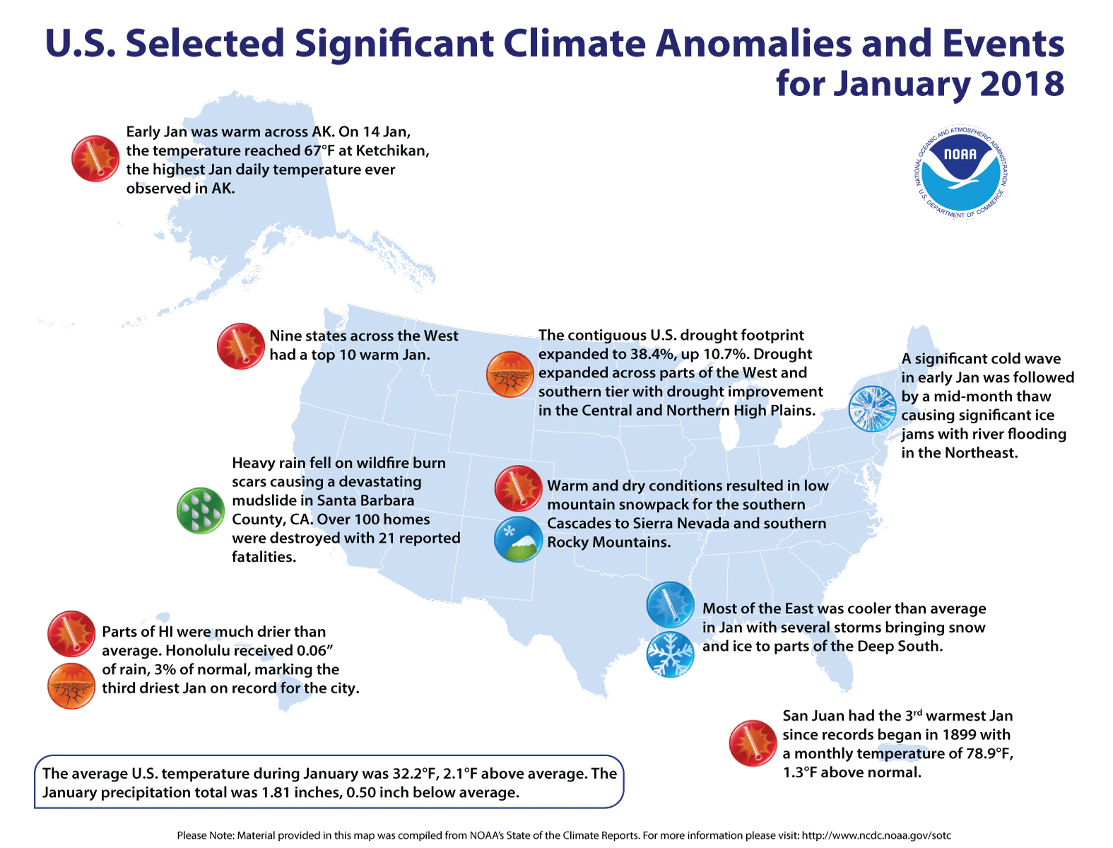
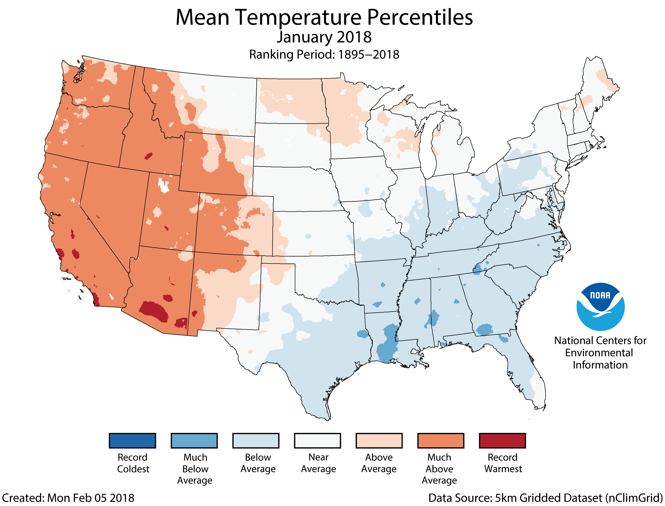
Warmth in the West contrasted with cold in the East
Depending on your location, January brought a warmer or colder start to the year. Data show that much-above-average temperatures in the West offset below-average conditions in the East and made for a slightly warmer-than-average January for the nation as a whole.
Perhaps the bigger news: The U.S. drought continued to expand and intensify to its largest area in nearly four years (May 2014). As of January 30, 38.4 percent of the contiguous U.S. was in drought, up from 27.7 percent at the beginning of January.
US Drought Monitor January 30, 2018.
Here’s how last month fared in terms of the climate record:
Climate by the numbers
January 2018
During January, the average temperature for the contiguous U.S. was 32.2 degrees F, 2.1 degrees above average, ranking among the warmest third in the 124-year record, according to scientists from NOAA’s National Centers for Environmental Information.
Most locations from the Rockies to the West Coast were warmer than average in January, where nine states had monthly temperatures that ranked among the 10 warmest on record and more than 2,000 daily warm temperature records were broken or tied. Below-average temperatures stretched from the Southern Plains to the East Coast. Several significant cold waves impacted the eastern half of the nation with more than 4,000 daily cold temperature records broken or tied.
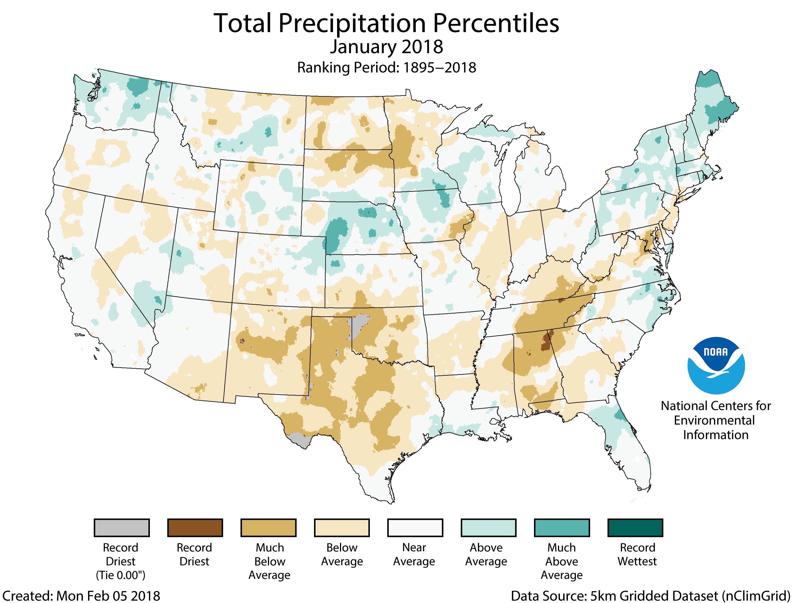
The precipitation total for the month was 1.81 inches, 0.50 of an inch below average, making it the 21st driest January on record. Below-average precipitation was observed across large areas of the country, including parts of the Southwest, Southern Plains, Northern Plains, Midwest, Southeast and Mid-Atlantic. Above-average precipitation was observed across parts of the Northwest, Central Plains and Northeast.
Other notable climate events for the month
Snowfall impacted the South, spared the West: During January, numerous snow storms impacted the eastern U.S. The Savannah, Georgia, airport received 1.2 inches of snow on January 4, the most since 1989 (See NASA’s satellite image above of Savannah area). Conversely, mountain locations in the Southern Cascades, Southern Rockies and Sierra Nevada Mountains had snowpack totals that were less than 25 percent of average.
Alaska experienced the warmest January temperature on record: On January 14, the temperature at a NOAA tide gauge at Ketchikan reached 67 degrees F, the highest January daily temperature ever measured in Alaska, besting the previous record of 62 degrees set in January 2014.
Pacific Islands were record-dry: Drought conditions spread and intensified into the U.S. Pacific Islands during January. Honolulu received 0.06 inches of rain, only three percent of normal, marking the third driest January on record. Guam record only 0.94 inches of rain, making it the driest January since records began in 1957.
During January, the average contiguous U.S. temperature was 32.2°F, 2.1°F above the 20th century average. This ranked among the warmest third of the 124-year period of record. Much-above-average temperatures in the West offset below-average conditions in the East. The January precipitation total was 1.81 inches, 0.50 inch below the 20th century average. This tied the 21st driest January on record. Drought intensified and expanded across parts of the West, Southern Plains and Southeast.
This monthly summary from NOAA’s National Centers for Environmental Information is part of the suite of climate services NOAA provides to government, business, academia and the public to support informed decision-making.
January Temperature
Most locations from the Rockies to the West Coast were warmer than average, where nine states had monthly temperatures that ranked among the 10 warmest on record. While no state was record warm during January, more than 2,000 daily warm temperature records were broken or tied across the region.
Below-average temperatures stretched from the Southern Plains to the East Coast. Several significant cold waves impacted the eastern half of the nation during January with more than 4,000 daily cold temperature records broken or tied across the East. No state had a record cold monthly temperature.
The Alaska January temperature was 6.8°F, 4.6°F above the long-term average. This ranked in the warmest third of the 94-year period of record for the state. The first half of January was mild across Alaska with a cold end to the month. On January 14, the temperature at a NOAA tide gauge at Ketchikan reached 67°F, the highest January daily temperature ever measured in Alaska. The previous record was 62°F in January 2014.
January Precipitation
During January, below-average precipitation was observed across large areas of the country, including parts of the Southwest, Southern Plains, Northern Plains, Midwest, Southeast and Mid-Atlantic. Alabama had its ninth driest January and New Mexico tied its 10th driest. Above-average precipitation was observed across parts of the Northwest, Central Plains and Northeast.
In January, numerous snow storms impacted the eastern U.S., bringing snow and ice to locations across the South that hadn’t experienced snow in many years. On January 4, the Savannah, Georgia, airport received 1.2 inches of snow, the most since 1989. Conversely, snow generally missed large parts of the West. Mountain locations in the Southern Cascades, Southern Rockies and Sierra Nevada Mountains had snowpack totals that were less than 25 percent of average. The lack of snow in the West could result in below-average spring runoff causing water resource concerns. Tourism in the region was also impacted.
According to the January 30 U.S. Drought Monitor report, 38.4 percent of the contiguous U.S. was in drought, up from 27.7 percent at the beginning of the month. This was the largest drought footprint since May 2014. Drought conditions expanded and intensified in parts of the West, Southern Plains and Southeast. Some drought improvement was observed in the Northern High Plains, Central Plains, Lower Mississippi Valley and coastal Southeast.
The NOAA National Weather Service issued a drought statement for Guam, Northern Mariana Islands and the Marshall Islands as drought intensified and spread during January 2018. With 0.94 inch of rain, the weather station at Guam observed the driest January in the 1957–2018 record.
One way water experts make progress is through collaboration, a key theme in Friday’s presentations and discussions at the fifth annual Poudre River Forum at the Island Grove Events Center, 501 N. 14th Ave. But working together isn’t always easy…
Even in the world of water experts, facts and evidence will often grab the attention of only the people whose biases are confirmed by the evidence. We learn in ways that don’t simply confirm our biases, Carcasson said, when we have genuine conversations with people we respect.
Ruth Quade, coordinator for Greeley’s Water Conservation program, said she’s worked with others her entire career in water conservation. Yet Carcasson’s presentation still rang true to Quade…
A panel of speakers highlighted some collaborations in the world of Colorado water: how state officials work with local water authorities to plan for water needs on a statewide scale, how the Fort Collins Water Utility worked with nearby water districts and more.
Kerri Rollins, manager of the Larimer County Open Space program, garnered the most questions after her presentation on a deal between the Larimer County Department of Natural Resources and the city and county of Broomfield. Larimer officials purchased a farm and its water rights southwest of Berthoud in 2016. They hoped to keep the farm in production, while offsetting costs through a water-sharing agreement. In August 2017, the alternative transfer method was finalized.
The agreement helps provide drought water to cities without the dichotomy that comes with “buy and dry” operations, where farms are permanently dried up. Rollins said the agreement was the first of its kind to share water from agricultural use to municipal use.
Click here to view the Twitter hashtag #poudreriverforum from last Friday.
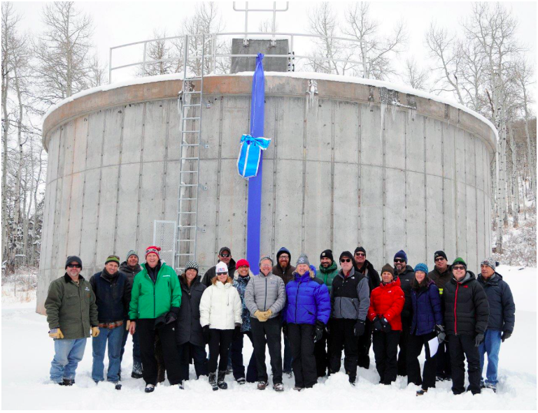
Eagle River Water & Sanitation District staff members with Upper Eagle Regional Water Authority board members and representatives of the town of Avon, Mountain Star Association, and contractors involved in developing and constructing the 270,000-gallon water storage tank in Mountain Star.
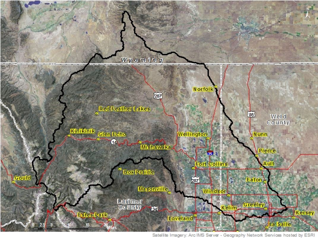
Winter in the Eagle River Basin has gotten off to a slow start, leading water managers to keep a close eye on snowpack and spring streamflow predictions.
As of Wednesday, Jan. 17, the Upper Colorado River headwaters were at 84 percent of normal precipitation for this water year, which runs from October 2017 through September 2018. The current snow totals could have big implications for the region’s water provider, the Eagle River Water & Sanitation District.
The Eagle River Water & Sanitation District monitors three snow telemetry, or SNOTEL, snow-measurement sites: Vail Mountain, Copper Mountain, and Fremont Pass. The Vail and Copper sites indicate what spring runoff might look like in Gore Creek and the town of Vail, according to district Communications and Public Affairs Manager Diane Johnson.
The Fremont Pass site is near the headwaters of the Eagle River, which indicates what runoff might look like in Avon and Edwards. As of Tuesday, Jan. 16, the Vail SNOTEL site was at 49 percent of normal, while the Copper and Fremont sites were at 87 percent and 100 percent, respectively.
“As a local water provider, where we want to see what might be available for our customers is right here in our basin,” Johnson said.
The Eagle River Water & Sanitation District is the second-largest water provider on the Western Slope. While most of the water for Colorado’s Front Range is stored in large reservoirs, Eagle River Water & Sanitation District reservoirs are augmentation and not used for direct supply.
‘Paying closer attention’
Streams need to flow to supply water to customers. That’s why Eagle River Water & Sanitation District is keeping a close eye on snowpack levels and streamflow predictions.
“We are paying closer attention,” Johnson said. “By the end of February, we might move a little bit more on that.”
According to the January Natural Resources Conservation Service Streamflow Forecast Summary, the Eagle River below Gypsum is predicted to have a streamflow that is 79 percent of average. No forecast point in the state is predicting above-normal streamflows.
“Eagle looks to be reasonably well set up to have potentially near-average streamflows,” said Karl Wetlaufer, a hydrologist with the Natural Resources Conservation Service snow survey. “Eagle is kind of in the middle of the pack, but in general, that region is faring as well as anywhere in the state.”
While Johnson said the Eagle River Water & Sanitation District does not feel either anxious or optimistic yet, staff members have been reviewing procedures from 2012, should 2018 turn out to be another drought year.
One of the biggest water savings comes from reducing outdoor use such as watering lawns and landscaping. According to Johnson, about 95 percent of water used indoors returns to the river after it’s been treated and somewhere between 15 percent and 40 percent of water used outdoors returns to the river.
“Indoor use has much less of an effect on the overall streamflow,” Johnson said. “So for us, that is a really huge thing around how we operate in low water years.”
In 2012, Eagle River Water & Sanitation District held stakeholder meetings throughout the spring, so water users were aware they might be asked to cut back. The goal was to find a healthy balance between using less water but not negatively impacting the economy or home values, part of which is having aesthetically pleasing greenery and landscaping.
Watering schedule
An outdoor watering schedule that permits watering three days a week before 10 a.m. or after 4 p.m. is in effect year-round. Unlike other water providers, where restrictions may be triggered when a reservoir dips below a certain level, Eagle River Water & Sanitation District does not have a specific threshold when more stringent regulations would be implemented.
Johnson said the district made some operational changes to respond to the 2012 drought, such as reassigning staff, closely monitoring streamflows, and fireproofing the valley’s 50 water storage tanks and booster pump systems.
Although they are not switching gears just yet, if dry conditions continue in Eagle River Water & Sanitation District’s service area again this year, then the water provider will respond much as it has in years past, Johnson said.
“I would say we are prepared,” Johnson said. “We have done this before. It’s kind of a bummer that it was only six years ago. I think as the new normal is established, a lot of this is becoming routine. We did not have water regulations prior to the 2000 drought, but by 2012, the regulations were known. We are investing a little bit of time now, but it’s too early to go full force.”
The statewide stats are stark. According to Wetlaufer, as of Tuesday, the 2018 water year has received just five inches of snow-water equivalent to make for the third-lowest snowpack statewide on record. Only 1980 and 2000 were drier, with 3.7 inches and 4.8 inches of snow-water equivalent, respectively.
Not even last week’s storms made much of a difference on a Colorado River Basin-wide scale. But snowpack totals vary by region, with the northern part of the state generally doing better than the southern half.
“The San Juans have seen it the most with very minimal precipitation for the last four months. … We are dealing with a pretty substantial deficit at this point,” Wetlaufer said.
Editor’s note: Aspen Journalism is collaborating with the Vail Daily, the Summit Daily, The Glenwood Springs Post Independent, and The Aspen Times on coverage of rivers and water. The Vail Daily published this story on Friday, Jan. 19, 2017.
Gore Creek is healthy as it emerges from the Eagles Nest Wilderness Area, but has problems soon after, via The Mountain Town News. All photos by Jack Affleck.
Click here to read the newsletter. Here’s an excerpt:
Where does all the traction sand go on Vail Pass?
The arrival of snow means traffic on I-70 over Vail Pass bustles with skiers and visitors to and from the Front Range, with cars braving storms and bumper-to-bumper traffic in search of a powder day. Without the help of traction sand or de-icers, our ability to constantly travel across the state would not be possible.
Roughly 5,000 tons of traction sand are laid down on Vail Pass each year, but where does all that sand end up? Originating from aggregate mines from the Western Slope and stored in the igloo tent atop Vail Pass, the sand is sprinkled along the highway corridor to ensure safer travel along the pass. Colorado Department of Transportation (CDOT) enlists contractors each year to come through in the late summer with vacuum trucks to suck up the remaining sand on the road ways and median. The used sand is then brought down to the berms that line the north side of the highway in East Vail. Sand is also flushed by rain and snow over the embankments and carried into sediment-catch basins or into Black Gore Creek, which closely parallels about 10 miles of the interstate from its headwaters at Vail Pass to the confluence of Gore Creek.
Extensive sediment loading to Black Gore Creek from nearly three decades of I-70 operations have severely impaired the stream, resulting in losses of aquatic habitat, impacts to wetlands and an overall reduction in water quality. In addition, the accumulation of sediment in Black Lakes near Vail Pass encroaches upon the storage capacity of water supply reservoirs that serve Vail and are used to maintain instream flows.
Black Gore Creek Steering Committee’s Efforts
Since 1997, the Black Gore Creek Steering Committee (BGCSC), headed by Eagle River Watershed Council, has worked to mitigate the impacts to Black Gore Creek and the health of its aquatic life. The committee is made up of a number of important partners in the community, including Eagle River Watershed Council, Colorado Department of Transportation, Eagle County, U.S. Forest Service, Town of Vail, Eagle County, Eagle River Water & Sanitation District, Lotic Hydrological, River Restoration, Colorado Parks & Wildlife, Colorado Department of Public Health & Environment, and concerned citizens.
In 2002, Black Gore Creek was listed on the State’s 303(d) list of impaired waters for sediment—which is different than Gore Creek’s more recent listing in 2012 for aquatic life impairment. Although the State has yet to come out with a limit of how much traction sand can enter the creek, CDOT, in collaboration with the other BGCSC partners, has taken great initiative to address these issues over the past 10 years.
Recent Accomplishments
To date, CDOT is picking up nearly the same amount of traction sand as they are putting down annually, which has improved since the years when no cleanup occurred, and the basins slowly filled.
Besides capital improvement projects such as repaving the medians and bike path enhancements, one of the most significant improvement projects has been the identification of a long-term maintenance solution for the Basin of Last Resort. A 3-acre section of Black Gore Creek around mile marker 183 on I-70, the Basin is a control structure that traps sediment missed by upstream catch basins. There has been concern with its effectiveness as the basin fills with sediment. In the fall of 2017, construction of a road allowing for easier access to excavate the basin more regularly and efficiently was finalized.
More work is to be done, however, as the goal is to have less sediment reach the Basin of Last Resort in the first place. Through field assessments, mapping activities, and sediment transport modeling, consultants to Eagle River Watershed Council, namely River Restoration and Lotic Hydrological, are working to identify opportunities for capturing traction sand before it leaves the highway corridor and enters the creek.
Traction Sand vs. Mag Chloride
CDOT has also installed sophisticated software in their plowing vehicles that senses how much traction sand or de-icer they should be applying on any given segment of the highway. The increased prevalence of de-icers, commonly referred to as “mag(nesium) chloride,” has been an inevitable outcome from the pressure on CDOT to reduce the amount of traction sand applied. Although very effective at melting snow and preventing ice formation, de-icers aren’t without their downsides. Studies have shown that elevated levels of chloride in rivers can be detrimental to aquatic life. The Watershed Council and CDOT both conduct chloride-loading studies to understand how chloride concentrations differ in Black Gore Creek and Gore Creek and whether they are approaching harmful levels.
“We don’t see the kinds of widespread impairments of the biological communities on Black Gore Creek that you would expect if they were really being negatively impacted by chloride. The health of those communities may be somewhat limited, but they do not meet the Colorado State definition for impairment right now,” reports Seth Mason of Lotic Hydrological. That is not to say that we shouldn’t be concerned about chloride levels in Black Gore Creek. While macroinvertebrate communities in Black Gore Creek may look better than those on Gore Creek through Vail, they may be stressed by elevated chloride concentrations and more vulnerable to other impacts on the creek. While more studies chloride’s effects are needed, the BGCSC is committed to not replacing one pollutant with another.
Related to Gore Creek’s Woes?
With all the recent attention on the Restore the Gore effort surrounding Gore Creek, some long-time locals believe the impacts from Black Gore Creek are at fault. Up until 2012, the State associated high sediment levels automatically with impaired aquatic life. In conducting macroinvertebrate sampling in our watershed, we are finding that aquatic bug scores on Black Gore Creek are healthier than those in the highly developed sections of Gore Creek through Vail. This along with other evidence leads to the belief that stormwater runoff from impervious surfaces in town and the loss of riparian areas along Gore Creek from development are a greater contributor to Gore Creek’s impairments.
The important efforts on Vail Pass have not slowed–in fact CDOT has spent about $7 million since 2013 to clear out the catch basins and sweep our roadways. The Watershed Council will continue the collaborative dialogue and mitigation efforts of the stakeholders to ensure the important progress continues in keeping our waterways healthy and clean.
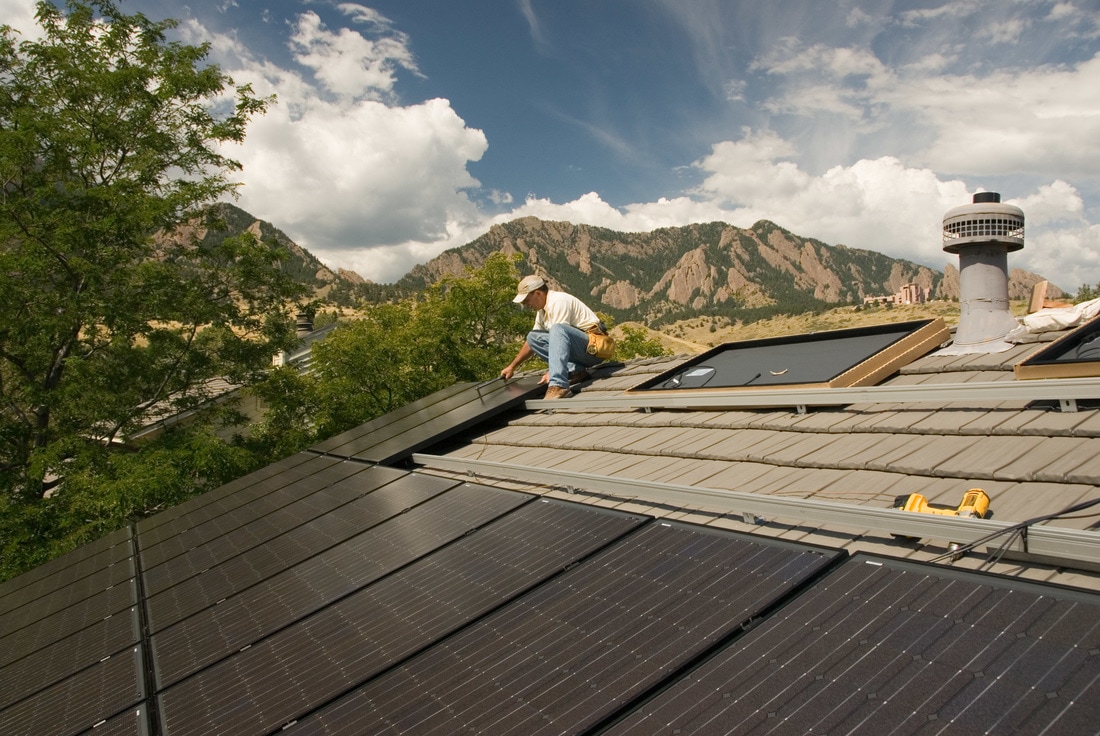
Boulder County Solar Contractor Residential Commerical. Photo credit: Flatiron Solar
Here’s the release from the University of Colorado at Boulder:
CU Boulder on Tuesday announced it has joined the University Climate Change Coalition (UC3), a newly formed coalition of 13 leading North American research universities that have united to help communities achieve their climate goals and accelerate the transition to a low-carbon future.
UC3’s initial cohort of member institutions—representing distinguished universities from the United States, Canada and Mexico—formally unveiled the initiative at the Higher Education Climate Leadership Summit in Tempe, Arizona, during a panel discussion that included CU Boulder Chancellor Philip DiStefano.
“With our university partners in UC3, we can meet the challenges of climate resiliency and sustainability,” DiStefano said. “Through leadership and innovation, together we can positively impact humanity now and for generations to come.”
CU Boulder Chief Sustainability Officer Heidi VanGenderen will serve as the primary campus liaison for the UC3 endeavor, working closely with Vice Chancellor for Infrastructure and Safety David Kang, Vice Chancellor for Research & Innovation Terri Fiez and other campus leaders.
For more than half a century, CU Boulder has been a leader in climate and energy research, interdisciplinary environmental studies programs, and engaging in sustainability practices both on campus and beyond. These endeavors fit within CU Boulder’s mission to improve communities through collaborative research, innovation and entrepreneurship.
Campus leaders have set a goal of reducing greenhouse gas (GHG) emissions by 20 percent by 2020 from a 2005 baseline, a 50 percent reduction by 2030, and an 80 percent reduction by 2050.
It is with this blend of history, expertise and determination that CU Boulder will contribute to the efforts of UC3, which aims to foster an exchange of best practices and lessons learned in pursuit of carbon neutrality and greenhouse gas reductions. Together, these institutions have committed to mobilizing their collective resources and expertise to help businesses, cities and states achieve their climate goals.
Two of UC3’s major initiatives in its first year include:
Cross-sector forums: Each UC3 institution will convene a climate change summit during the 2018 calendar year to bring together community and business leaders, elected officials and other local stakeholders. Summits will be tailored to the local and regional context and will focus on proven, research-tested policies and solutions that can help communities achieve their climate goals and/or plan for resiliency in the face of a changing climate.
Coalition climate mitigation and adaptation report: A coalition-wide report, to be released in late 2018, will synthesize best practices, policies and recommendations from all UC3 forums into a framework for continued progress on climate goals across the nation and the world.
UC3 will operate in close partnership with Second Nature’s Climate Leadership Network, a group of hundreds of colleges and universities, of which CU Boulder is also a member, that have committed to taking action on climate.
Harnessing the exceptional resources and convening power of member institutions, the coalition will work to inform and galvanize local, regional and national action on climate change. Coalition members will bring to these efforts a critical body of expertise in areas including climate modeling, energy storage systems, next generation solar cells, energy-efficiency technologies, smart grids, transportation sector innovations, regulatory and policy approaches, and more.
In 2015, the U.S.-based members of the UC3 coalition together performed almost a quarter of the environmental research conducted by all U.S. institutions, according to data collected by the National Science Foundation.
“The research university has played an important role in creating new knowledge, convening thought leadership and serving as long-term community members,” Second Nature President Timothy Carter said. “By applying these strengths to locally relevant climate challenges, we see transformative potential for accelerating climate solutions in these locations in a way that couldn’t happen if the institutions and sectors continued to act on their own.”
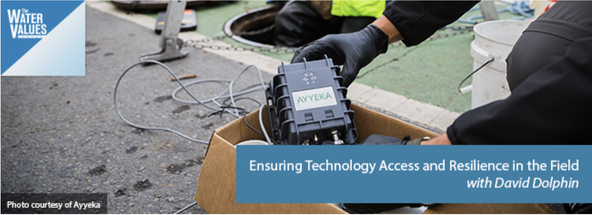
Click here to listen to the podcast (David McGimpsey):
David Dolphin, of utility technology provider Ayyeka, discusses a wide range of issues related to end-to-end remote monitoring system deployment. David covers signal strength, data encryption, battery life and other issues that utilities need to consider when evaluating a remote monitoring technology solution. You’re guaranteed to learn something by listening!
Plus, this episode also has Reese Tisdale in our Bluefield on Tap segment where Reese discusses big picture issues in the water sector, including the slow-moving train wreck that resulted in Cape Town’s water emergency.
In this session, you’ll learn about:
How signal strength affects remote monitoring solutions
Why having a remote monitoring solution that connects to multiple networks is important
Considerations for battery life in a remote monitoring technology
Using remote monitoring solutions with GPS/GIS technology to identify trends or hot spots
How data encryption factors into a remote monitoring solution
How materials maintain waterproof qualities in distribution or collection systems
During this period of La Niña, which can last up to five months, little, if any, precipitation makes it to Southwest Colorado as storms are pushed up to the northern parts of the state.
And this year, Cuoco said it’s playing out like a classic La Niña year.
As of Sunday, Southwest Colorado’s snowpack is at 34 percent of normal averages, while the Colorado, North and South Platte, and Yampa river basins are experiencing upwards of 75 percent of normal snowpack.
According to NWS data, only 0.39 inches of precipitation were recorded at the Durango La Plata County Airport for the entire month of January, about 1.12 inches below historic averages.
Last year, which was an El Niño year, more than 2.35 inches of precipitation was recorded for the month of January at the Durango-La Plata County Airport weather station.
Also, this past January was nearly 5.5 degrees warmer than historic averages.
The U.S. Drought Monitor lists nearly all of Western Colorado and the Four Corners region in a “severe drought.”
And unfortunately, NWS models show no signs of La Niña going anywhere anytime soon.
While scientists are able to track and measure global oceanic circulations, and know how these cycles move, they are less certain about the driving forces behind it, Cuoco said.
“What causes surface water temperatures in the ocean to warm back up toward normal, or to cool down?” Cuoco said, “we really don’t have that answer yet.”
Cuoco said the World Meteorological Organization, an intergovernmental organization comprised of 191 countries and territories, has been funding research to get at the answer for years.
These oscillations in surface water temperature have resounding impacts on weather conditions around the globe.
In El Niño years, for instance, parts of Southern Africa, the Philippines, Mexico and Central America may experience extreme drought, while areas like Bolivia, Ecuador and Cuba may get hit with catastrophic flooding.
Therefore, understanding what causes a particular year to have warm or cold surface water temperatures is a question sought after by the international community, Cuoco said.
“It’s something that has been well funded with widespread research in the hopes of understanding,” he said.
As for Southwest Colorado and its parched landscape, any hint of snow comes as a bit of good news.
Cuoco said there’s a slight chance the high country north of Durango – areas around Silverton, Hesperus, Rico and Ouray – have a 30 to 40 percent chance of scattered snow showers Monday through Tuesday.
If the storms pan out, it may drop a couple of inches, Cuoco said.
The Colorado Basin River Forecast Center’s water supply forecast map shows several river basins projected to be below average during the spring runoff season. Credit Colorado Basin River Forecast Center / National Oceanic and Atmospheric Administration
Be prepared for some of the West’s biggest and most important rivers and streams to see record low flows this spring and summer.
That’s the message of the Colorado Basin River Forecast Center’s latest water supply forecast released Monday.
“Below average precipitation continued to be the norm and not the exception for the month of January,” the forecast report reads. “January marks the fourth consecutive month of the 2018 water year with widespread below average precipitation.”
The center’s forecasters are projecting the flows into Lake Powell — one of the largest human-made lakes in the country — to be 47 percent of average. The lake, on the Utah-Arizona border, is part of a reservoir system that supplies water to some 40 million people in the southwest. As of early February Lake Powell was at 56 percent of full capacity, while its sister reservoir, Lake Mead, was at 41 percent of full capacity.
The news is worse in the Colorado River’s lower basin, which includes Arizona, and portions of New Mexico and Nevada. In those states, spring runoff from February to May is projected to be be less than 30 percent of median.
The lowest water supply forecasts in the Upper Colorado River include the Dolores and San Juan Rivers in southwest Colorado, and across central and southern Utah including the Virgin, Sevier, and San Rafael River Basins.
Parts of the southern Rocky Mountains are currently experiencing the warmest and driest winter on record. Snowpack eventually turns into the region’s water supply, and without it, rivers and streams suffer. Snow measurement sites in southern Colorado, central Utah, and Arizona are reporting their lowest levels on record…
Last year’s above-average snowfall in the southern Rockies boosted reservoir levels throughout the region giving water managers some buffer to withstand a dry year, with both Arizona and New Mexico being the exception. Those two states are currently reporting below average reservoir storage.
The unusually dry winter has people in Colorado and across the West talking about the vagaries of the weather. But the more important conversation is about climate change.
Reporter Jacy Marmaduke wrote an interesting story that ran in the Jan. 28 print version of the Coloradoan — and, of course, on Coloradoan.com — about how climate change is affecting the state’s ski industry and how that impact is predicted to worsen in the decades to come.
There was a lot of bad news for fans of winter outdoor activities such as hitting the slopes at resorts in Summit County or snowshoeing in the upper reaches of the Poudre Canyon. Although snowfall amounts vary from year to year, the overall trend for the snowpack is less accumulation and earlier melting than in years past.
Snowpack has decreased 20 to 60 percent at most monitoring sites in Colorado since the 1950s, according to an Environmental Protection Agency analysis. Colorado’s average temperature has increased more than 2 degrees in the past 40 years.
Those trends are expected to continue. For ski resorts, decreasing snow translates to shorter ski seasons. The economic impact of that on resorts and the state’s vital tourist industry is profound.
However, there’s more for Coloradans to worry about than the financial well-being of ski resorts and the number of powder days skiers may enjoy. Our mountains hold the headwaters of major rivers, including the Colorado River, that supply water to a large part of the country.
Decreased snowpack and earlier runoff because of the shifting climate will require significant changes to how water is managed and conserved in river basins across the West. Other impacts include serious threats to agricultural production as well as healthy forests and rivers.
So what can individuals and society do about this? We can’t make more snow fall or otherwise change the weather, but we can take steps to lessen our contribution to forces science tells us are factors in climate change.
Local entities such as the city of Fort Collins, Colorado State University and Platte River Power Authority are leading the way in climate action through programs and policies aimed at reducing the community’s emission of greenhouse gases.
The city’s Climate Action Plan is one of the most aggressive municipal plans in the country, if not the world. The plan calls for dramatic reductions in greenhouse gas emissions in the coming years, with the goal of the community being carbon neutral by 2050.
These conservation goals will not be easily achieved. Getting there will require the cooperative efforts of individuals and large organizations alike.
A good source of information on Fort Collins’ work on climate action may be found on the city website fcgov.com/climateaction. The site includes access to a Climate Action Plan dashboard, which gives a snapshot view of the community’s progress on meeting its goals.
The dashboard is a work in progress, with some informational entry points labeled “coming soon.” But it provides access to reports on the city’s activities, including an Innovation Summit planned Feb. 12 to brainstorm ways to achieve Climate Action Plan goals.
Some might say that given the worldwide scope of climate change and the tremendous challenges it presents, efforts by one community in Northern Colorado to address it are not likely to make any difference.
A less cynical way of looking at climate action is that steps taken at the local level could provide important momentum toward finding answers to a big problem.
And we are not alone. Communities and countries around the world are taking action in the face of climate change in hopes of ensuring a livable world for future generations.
Colorado Springs fisherman Roger Hill has had repeated run-ins with Mark Warsewa, whose property spans the Arkansas River between Texas Creek and Cotopaxi. Hill likes to wade from public land nearby and fish in the river near Warsewa’s place.
“I own the bottom of the river,” said Warsewa, who bought the property in 2006.
Hill on Friday sued Warsewa in U.S. District Court, arguing the bottom of the river actually is public property. His lawyers point to a federal doctrine called “navigability for title,” which holds that if a waterway was used for commercial activity at the point of statehood, the state owns the stream bed and the public has access.
With historical records showing loggers sending hundreds of thousands of railroad ties down the Arkansas River before Colorado became a state in 1876, Hill’s attorneys hope to prove “navigability for title” and, therefore, unfettered public access.
If Hill wins, the Arkansas River could be open for wade fishing through private land, and the standard could apply to just about every Colorado waterway. It also could resolve a thorny public-access issue that Colorado’s Western neighbors — New Mexico, Idaho, Montana, Wyoming and Utah — have cleared up in recent years.
“There has been a lot of confusion around this. Private landowners have been led to believe that they have the right to block access to waterways in front of their property, but that is only true if that river was not navigable for title purposes,” said Mark Squillace, a professor at the University of Colorado Law School who, with Dillon attorney Alexander Hood, is representing Hill. “This case has the potential to bring some clarity to the law and show that, yes, like any other state in the country, we have the right to access state-owned river beds under navigability for title.”
Stream-access issues erupt every several years in Colorado. A landowner on the Lake Fork of the Gunnison River in 2001 sued to block a river outfitter from floating guests past his property. Owners at a private fishing community on the South Platte River above Cheesman Gorge once chained a gate to the riverbed to block kayakers from passing through the property.
Still, little has been done to permanently resolve stream- and river-access conflicts in Colorado. No state laws or regulations define navigability.
The Colorado Supreme Court, in the seminal 1979 People vs. Emmert case, upheld a trespass conviction against rafters who floated on the Colorado River through private property in Grand County. In 1983, the Colorado attorney general sought to clarify the court’s decision with a legal opinion that paddlers floating through public property only commit criminal trespass if they touch the river bottom. The boaters could, however, be charged with civil trespass.
Colorado still relies on the 1983 legal opinion, which is not binding and has not been tested by a Colorado court. (Colorado and Arizona recently finished below six other Western states for stream access in the annual Western States Conservation Scorecard by the Center for Western Priorities.)
In 2011, then-Colorado Gov. Bill Ritter created a River Access Mediation Commission to help resolve access conflicts between landowners and boaters. That commission has not been appointed since 2015.
The Hill lawsuit highlights “an interesting point” with the evidence of commercial activity on the Arkansas River before Colorado’s statehood, said Nathan Fey, the Colorado stewardship director for American Whitewater. But he’s nervous. A victory or loss could have sweeping impacts across the state, he said.
“Regardless of which way this goes, there’s going to be trouble,” said Fey, whose job entails traveling around the state dealing with river access conflicts on a case-by-base basis.
If Hill wins, Fey said, the next issue will be to address whether the state has the right to claim a riverbed property that previously was considered private property and how much, or if, that landowner should be reimbursed if that property is deemed public. If Hill loses, Fey said, “it could have much broader implications for a pretty robust outdoor recreation economy surrounding water in Colorado, especially on the Arkansas, the nation’s most rafted river.”
“I think there’s a lot of risk here,” said Fey, noting that wading fishermen are clearly contacting the river bottom in violation of the 1983 legal opinion and this case could force a decision that impacts floating boaters.
Warsewa, who learned of the lawsuit Friday, said he doesn’t have issues with rafters or fishermen floating the Arkansas River through his property. He does have problems with fisherman walking on the river just past the riverbank below his home. In 2015, he pleaded guilty to a menacing charge after firing a handgun when fishermen were in the water.
A bipartisan group of Colorado lawmakers has introduced a new bill with the hopes of ensuring access to Colorado’s natural resources for future generations, by finding a long-term funding solution for Colorado Parks and Wildlife (CPW).
The bill is sponsored by two Republicans – Sen. Don Coram of Montrose and Rep. Jim Wilson of Salida – as well as two Democrats – Sen. Stephen Fenberg of Boulder and Rep. Jeni Arndt of Fort Collins.
CPW said the bill was introduced after roughly three years of public meetings with legislators and outdoor enthusiasts, regarding the agency’s financial challenges and the future of Colorado’s outdoor recreation, state parks, and wildlife.
CPW receives less than one percent of it’s annual budget from general fund tax revenue. They rely primarily on sales of hunting and fishing licenses, park passes, and camping fees. With the proposed bill, the agency is seeking approval to adjust fees to cover the rising costs associated with managing wildlife, protecting habitat, and maintaining and improving state parks to meet the needs of a growing population.
With new funding the bill would bring, CPW said they are committed to pursuing the following goals and objectives by 2025:
Grow the number of hunters and anglers in Colorado through investments in programs such as hunter education, Fishing is Fun, and the Cameo Shooting and Education Complex, and grants for shooting ranges in all regions of the state.
Expand access for hunters, anglers and outdoor recreationists by renewing existing high-priority leases and supporting additional public access programs on public and private lands.
Increase and improve big game populations through investments in habitat and conservation, including building more highway wildlife crossings to protect wildlife and motorists.
Improve species distribution and abundance monitoring and disease prevention efforts through partnerships with private landowners.
Increase the number of fish stocked in Colorado waters to above 90 million through hatchery modernization and renovations.
Identify and begin planning the development of Colorado’s next state park.
Reduce risks to life and property and sustain water-based recreation opportunities by reducing CPW’s dam maintenance and repair backlog by 50 percent.
Engage all outdoor recreationists, such as hikers, bikers, and wildlife watchers, in the maintenance of state lands and facilities and the management of wildlife.
Recruit and retain qualified employees to manage wildlife, park, recreational and aquatic resources.
Provide quality infrastructure at CPW properties by completing much needed construction and maintenance.
In order to achieve these objectives, the bill would adjust fees for hunting and fishing licenses, as well as park passes. Hunting and fishing licenses would increase by $8. For example, an annual fishing license would increase from $26 to $33, and an elk tag would increase from $45 to $53. The bill would however reduce the price of an annual fishing license for those 16 and 17-years-old to $8. It would also allow the Parks and Wildlife Commission to implement other license discounts, in order to introduce a new generation of hunters and anglers to the outdoors.
In addition to licenses, the proposed bill would CPW to raise state park entrance fees. Any increase though would be capped at $1/year for a daily pass, and $10/year for an annual pass.
For more information on the Future Generations Act, you can visit the CPW website at the following link: Future Generations Act
District Executive Director Callie Hendrickson, of Grand Junction, reviewed subjects including rangeland health and monitoring; excess horses on public range; range improvement programs and opportunities; greater sage grouse management; and water issues. The latter includes facilitation, on behalf of the county, of the deliberations and research of the county’s White River Algae Task Force. The mission of the task force, Hendrickson stated, is “to ascertain what is driving the algae growth in the White River (in order) to improve the overall health of the watershed.”
The 2018 Plan of Work presented covers the development and implementation of the rangeland monitoring and weed control project with the federal Bureau of Land Management on the Piceance-East Douglas (Wild Horse) Herd Management Area; ongoing facilitation of the White River Algae Task Force; continuing utilization of the Land and Natural Resource Plan and Policies developed by the districts and approved by the board of county commissioners as a guide to public lands use; continuing equipment rental, tire tank and polyacrylamide (PAM) sales for sites where quick fixes are needed on dam areas where there are known leaks and for setting up the surface for new ponds as well as flooded field irrigation and ditch projects; continuing excess wild horse education; continuing work with partners to support the wise use of natural resources; and working to secure long-term sustainable funding to replace losses in mill levy funding.
Enterprise Products, Williams gas company, and XTO Energy were the primary sponsors of the district dinner this year. Steve Cochran, Enterprise manager, and Darren Baker, representing Williams, were presented “thank you” awards for the sponsorships. Past district manager Chris Colflesh and his bride, Kim O’Donnell, both now of Silt, were also honored.
The Natural Resources Conservation Service district conservationist, Kendall Smith from Craig, whose jurisdiction covers Moffat and Rio Blanco Counties; Kent Walter, field manager for the White River Field Office of BLM; and U.S. Forest Service Rio Blanco District Ranger, Curtis Keetch, each gave updates on the activities of their agencies.
The evening’s program closed out with presentations by Colorado Parks and Wildlife water quality guru Mindi May, Denver, and Elk Creek Ranch fishing manager Colton Brown sharing their perspectives on the White River algae situation.
As of Thursday, 38.4% of the continental U.S. is in a drought, according to the U.S. Drought Monitor. That is the highest percentage since the 40% recorded in May 2014.
In California, which emerged from a brutal four-year drought last year, 44% of the state is now considered to be in a moderate drought. That’s a dramatic jump from just last week, when the figure was 13%.
Major winter storms have mostly bypassed the West, meaning that much-needed mountain snow has not fallen, said NOAA meteorologist Richard Heim, author of this week’s Drought Monitor. This winter, snow sensors across the Sierra Nevada show the snowpack is just 30% of average for this time of year.
Extremely warm weather is causing most of the precipitation to fall as rain instead of snow. “This will have major ramifications for western water managers if they don’t get some major winter storms soon,” Heim said.
Whether California heads into another drought cycle will depend largely on how much rain and snow falls during February and March.
Further east, the amount of snow on the ground is also far below average across the Colorado River Basin, where a 17-year run of mostly dry years has left reservoirs at alarmingly low levels.
“Mountain snowpack was abysmally low, reaching record low levels for this time of year in parts of New Mexico and Colorado,” Heim wrote in the monitor this week.
Climate scientists and managers of water agencies describe the situation as a “snow drought,” driven in part by winter temperatures that are well above the long-term average.
The southern Plains has also been bone-dry, where some spots haven’t seen a drop of rain in months. In Amarillo, Texas, for example, no measurable precipitation has fallen for a record 111 days…
In Oklahoma, pasture conditions were generally poor and deteriorating and 79% of the winter wheat crop was rated in poor to very poor condition, the Drought Monitor said.
Looking ahead, drought is expected to either persist or intensify over the next several months, the Climate Prediction Center said.
“The general trend of increasing drought coverage should continue through the end of April, as most areas of drought are expected to persist, along with development forecast in parts of southern California, central Colorado, and the southern Plains,” the center said.
Farmers’ switching to lettuce, which uses less water because it’s cultivated only part of the year, from alfalfa, a thirsty year-round crop, helped push the lake to 1,087.6 feet (331.5 meters) above sea level as of Jan. 31. That’s more than 1 foot higher than a year ago and above the benchmark of 1,075 feet, at which point regional water restrictions kick in.
The improvement, which brought a sigh of relief to a dry region, is mostly due to a record snowpack in the Sierra Nevada mountains that ended California’s drought by early 2017. But some credit goes to farmers, the biggest users of the region’s water, who in some places have been doing exactly what climate experts say they should be doing—switching crops for conservation reasons.
A look at 28 years of data from the Imperial Valley—a major crop-growing region spanning southeast California, bordering Mexico and Arizona and relying on Colorado River water—shows how farmers battling water scarcity have shifted acreage.
Acreage planted in alfalfa, a low-value forage crop, has declined 25 percent to 148,642 acres since 2001, according to December 2017 figures. Lettuce growth has increased 79 percent to 31,382 acres in the same period.
The shift is a combination of market and government incentives, said John Fleck, director of the University of New Mexico’s Water Resources Program in Albuquerque. Water-sharing agreements with local governments have reduced use at the same time that distribution networks for fruits and vegetables have improved, making it possible to ship fresh lettuce and other produce to more markets.
“Cutting water use doesn’t have to be the end of agriculture,” Fleck said. “Farmers with less water to use will maximize their drops, and find a way to maximize their profits.”
The changeover challenges the conventional wisdom that water demands don’t ease. It doesn’t, however, solve the long-term problems of the Colorado River. This year could be more difficult, with snowpack well below normal, according to the U.S. Bureau of Reclamation. The basin’s population may rise as much as 91 percent by 2060.
Explorer: This robot may have made a momentous discovery in a 2,000-year-old tunnel in Mexico. Photo credit: DailyMail.com.
From the Associated Press (Dan Elliott) via The Detroit News:
the EPA is considering using robots and other sophisticated technology to help prevent these types of “blowouts” or clean them up if they happen. But first the agency has to find out what’s inside the mines, some of which date to Colorado’s gold rush in the 1860s.
Wastewater containing toxic heavy metals has been spewing from hundreds of inactive mines nationwide for decades, the product of complicated and sometimes poorly understood subterranean flows.
Mining creates tainted water in steps: Blasting out tunnels and processing ore exposes long-buried, sulfur-bearing rocks to oxygen. The sulfur and oxygen mix with natural underground water flows to create sulfuric acid. The acidic water then leaches heavy metals out of the rocks.
To manage and treat the wastewater, the EPA needs a clear idea of what’s inside the mines, some of which penetrate thousands of feet into the mountains. But many old mines are poorly documented.
Investigating with robots would be cheaper, faster and safer than humans.
“You can send a robot into an area that doesn’t have good air quality. You can send a robot into an area that doesn’t have much space,” said Rebecca Thomas, project manager for the EPA’s newly created Gold King Superfund site, officially known as the Bonita Peak Mining District.
Instruments on the robots could map the mines and analyze pollutants in the water.
They would look more like golf carts than the personable robots from “Star Wars” movies. Hao Zhang, an assistant professor of computer science at the Colorado School of Mines, envisions a battery-powered robot about 5 feet long with wheels or tracks to get through collapsing, rubble-strewn tunnels.
Zhang and a team of students demonstrated a smaller robot in a mine west of Denver recently. It purred smoothly along flat tunnel floors but toppled over trying to negotiate a cluttered passage…
A commercial robot modified to explore abandoned mines – including those swamped with acidic wastewater – could cost about $90,000 and take three to four years to develop, Zhang said.
Significant obstacles remain, including finding a way to operate remotely while deep inside a mine, beyond the reach of radio signals. One option is dropping signal-relay devices along the way so the robot stays in touch with operators. Another is designing an autonomous robot that could find its own way.
Researchers also are developing sophisticated computerized maps showing mines in three dimensions. The maps illustrate where the shafts intersect with natural faults and provide clues about how water courses through the mountains.
“It really helps us understand where we have certainty and where we have a lot of uncertainty about what we think’s happening in the subsurface,” said Ian Bowen, an EPA hydrologist. “So it’s a wonderful, wonderful tool.”
The EPA also plans to drill into mines from the surface and lower instruments into the bore holes, measuring the depth, pressure and direction of underground water currents.
Tracing the currents is a challenge because they flow through multiple mines and surface debris. Many tunnels and faults are connected, so blocking one might send water out another.
“You put your finger in the dike here, where’s the water going to come out?” Thomas said.
Once the EPA finishes investigating, it will look at technologies for cleansing the wastewater.
Options range from traditional lime neutralization – which causes the heavy metals dissolved in the water to form particles and drop out – to more unusual techniques that involve introducing microbes.
The choice has consequences for taxpayers. If no company is found financially responsible, the EPA pays the bill for about 10 years and then turns it over to the state. Colorado currently pays about $1 million a year to operate a treatment plant at one Superfund mine. By 2028, it will pay about $5.7 million annually to operate plants at three mines, not including anything at the Bonita Peak site.
The EPA views the Colorado project as a chance for the government and entrepreneurs to take risks and try technology that might be useful elsewhere.
But the agency – already dealing with a distrustful public and critical politicians after triggering the Gold King spill – said any technology deployed in Colorado will be tested first, and the public will have a chance to comment before decisions are made.
On April 7, 2016, the Environmental Protection Agency proposed adding the “Bonita Peak Mining District” to the National Priorities List, making it eligible for Superfund. Forty-eight mine portals and tailings piles are “under consideration” to be included. The Gold King Mine will almost certainly be on the final list, as will the nearby American Tunnel. The Mayflower Mill #4 tailings repository, just outside Silverton, is another likely candidate, given that it appears to be leaching large quantities of metals into the Animas River. What Superfund will entail for the area beyond that, and when the actual cleanup will begin, remains unclear. Eric Baker
Colorado’s snowpack levels are roughly 60 percent of their historical average, and the southern reaches of the state remain in dire straits with only several months left in the snow season. Overall, it’s shaping up to be the state’s worst winter since 2012.
Water managers aren’t quite panicking yet, thanks to healthy reservoir levels that should be able to provide a backstop against drought. But if things don’t turn around soon, some of the many water jurisdictions fed by Colorado’s high-elevation snowpack could be in for tough times.
“There are some parts of the state that are in dire situations,” said Jim Pokrandt, director of community affairs for the Colorado River District, a state water policy agency. “I think it would be wise for water providers to look around the corner. We could still get up to 100 percent, but people should certainly start thinking about drought planning.”
As dismal scenes from Crested Butte and Telluride can attest, the southern mountains are faring the worst. The latest data show two river basins in the southwest corner of the state — the Upper Rio Grande and the San Miguel, Dolores, Animas and San Juan — at 34 and 36 percent of average snowpack, respectively. The Gunnison basin to the north isn’t doing much better at 47 percent of historical snow-water equivalent.
The Upper Colorado River basin, which includes Summit County, is currently at a respectable 75 percent of average, owing partly to a La Niña affect that has been pushing storms northward.
A closer look indicates that despite underwhelming snow accumulations at local ski areas, Summit County has been having an unusually strong winter. Measurements by Denver Water show that snowpack on the mountains that drains into Dillon Reservoir is roughly 105 percent of its historical average.
“We’re faring a little bit better than the rest of the state, and in some areas like Summit County, we’re actually doing better than we typically would be this time of year,” said Travis Thompson, a Denver Water spokesman.
In all areas of the Upper Colorado River watershed where the agency collects water, snowpack is at 97 percent of normal, and its sites in the Upper South Platte watershed are at 91 percent.
Summit enjoyed a light dusting on Thursday that was expected to continue periodically into the weekend. Weak storms like that have characterized the 2017-18 winter season so far, a stark contrast to the season before, when a series of massive storms pummeled the county in December and January and built most of the winter’s total snowpack.
“We’re inching up and every little bit counts — a couple inches today, a couple inches tomorrow,” Pokrandt said. “Everybody’s looking for a 2-foot dump for a lot of reasons, but we’ll take what we can get. We’re inching ahead. … This year we just haven’t gotten that pineapple express effect that comes across dumping and dumping.”
One way water experts make progress is through collaboration, a key theme in Friday’s presentations and discussions at the fifth annual Poudre River Forum at the Island Grove Events Center, 501 N. 14th Ave. But working together isn’t always easy…
A panel of speakers highlighted some collaborations in the world of Colorado water: how state officials work with local water authorities to plan for water needs on a statewide scale, how the Fort Collins Water Utility worked with nearby water districts and more.
Colorado River headwaters tributary in Rocky Mountain National Park photo via Greg Hobbs.
From the Associated Press (Michael Biesecker) via The San Diego Union Tribune:
TThe Trump administration on Wednesday delayed implementation of an Obama-era clean water rule by another two years to give the Environmental Protection Agency and the Army Corps of Engineers more time to do away with it.
The move follows a Supreme Court ruling last week that said legal challenges to the Waters of the U.S. rule should be decided in federal district courts. That will result in the lifting of a stay issued by an appeals court blocking the 2015 rule from going into effect.
The rule expanded the definitions for wetlands and small waterways under the Clean Water Act — prompting opposition from agribusiness, mining and industry groups. The expansion was intended to reduce sources of pollution dumped in the small tributaries of larger lakes and rivers.
President Donald Trump issued an executive order nearly a year ago ordering a review of the WOTUS rule. By moving the effective date to 2020, the Trump administration buys itself more time to issue a replacement.
EPA Administrator Scott Pruitt routinely cites WOTUS as what he sees as regulatory overreach by the prior administration.
“EPA is taking action to reduce confusion and provide certainty to America’s farmers and ranchers,” Pruitt said Wednesday, according to a statement. “The 2015 WOTUS rule developed by the Obama administration will not be applicable for the next two years, while we work through the process of providing long-term regulatory certainty across all 50 states about what waters are subject to federal regulation.”
Pruitt’s fellow Republicans quickly praised the two-year delay.
“The Obama administration’s outrageous Waters of the United States rule would have put backyard ponds, puddles and farm fields under Washington’s control,” said Sen. John Barrasso of Wyoming, chairman of the Senate environment committee. “This delay gives the Trump administration time to revise this rule.”
Environmentalists predicted the rewrite will let polluters off the hook.
“The Trump administration is playing politics with our drinking water,” said Janette Brimmer, a lawyer with the legal advocacy group Earthjustice. “We need to protect the streams and wetlands that provide the drinking water of one in three Americans. This delay is an obvious attempt to make it easier for corporate interests to pollute our waterways.
Sheep Herders on the Uncompahgre Plateau back in the day
Pruitt’s administration said it will rewrite the rule, which was adopted in 2015 and described as the most signficant overhaul to the Clean Water Act in more than 40 years. The two-year cooling off period will allow the EPA and the U.S. Army Corps of Engineers to once again revisit where they have jurisdictional oversight.
At the time of the rule’s adoption, federal regulators said it only clarified protections for seasonal waterways critical to downstream communities.
Critics, however, said that “clarification” extended the agencies’ regulatory authority to dry creek beds, drainage ditches and puddles.
In Utah in particular, critics feared intermittent or ephemeral drainages would be looped in under the rule.
Environmental groups and conservation organizations said the rule protected critical wetlands. Seven scientific organizations urged the Trump administration to leave the rule untouched.
But farmers and ranchers were adamant over a repeal or rewrite of the rule.
“We applaud the EPA and Army Corps for hitting the pause button while we search for added clarity and certainty for America’s farmers,” said Dennis Nuxoll in a statement released by the Western Growers, which represents local and regional farmers in multiple Western states.
The Utah Farm Bureau pushed for the rule’s demise, and the Utah Legislature in 2016 passed a resolution urging support for Utah Attorney General Sean Reyes’ efforts to have the courts vacate the new regulations.
Rodeo Rapid, on the upper Colorado River. Photo credit: Brent Gardner-Smith Aspen Journalism
Here’s the release from the Attorney General’s office:
Colorado Attorney General Cynthia H. Coffman announced today that her office filed a brief in the U.S. Supreme Court in State of New York v. Environmental Protection Agency, No. 17-418. The brief was filed on behalf of the State of Colorado and ten other western states, and in cooperation with dozens of western water providers. The brief is the latest effort by Colorado in a nearly decade-long battle to support the Environmental Protection Agency’s Water Transfers Rule, a federal regulation that recognizes the right of States to manage “water transfers”—projects that ensure water is available where it is needed most.
Water transfers are critically important, especially in the arid West. Without them, local water providers from Denver to Los Angeles could not deliver essential water supplies for municipal, industrial, and agricultural use. Water transfers are typically government operated and do not introduce pollutants into sources of water. They simply move water from one natural source and transport it for use elsewhere.
EPA’s Water Transfers Rule recognizes that States have always had authority to regulate these activities. Yet a group of litigants, including a coalition of eastern States led by New York, have argued that water transfers should be subject to costly and burdensome regulations under the Clean Water Act. This would be contrary to decades of policy by the EPA and to Congress’ decision to defer to state authority to manage water resources.
“Water is the lifeblood of the West,” said Attorney General Coffman. “We’ve often had to fight to keep our authority to manage and protect this critical natural resource, and Congress has recognized that the regulation of water resources should be close to home. We protect our water and we have many tools to ensure that it is managed in an environmentally responsible way. There is simply no need to require States in the West to jump through additional, costly federal hoops that do nothing to protect our water resources.”
In March 2017, a decade after it first applied, wholesale electrical supplier Tri-State Generation & Transmission and its Kansas-based utility partner received approval to build a major new coal-fired power plant at Holcomb, Kan. It will almost certainly never get built.
The energy world turned upside down in the 10 years between first application and final approval. Electrical demand, rising steadily at the turn of the century, flattened. Prices of other forms of generation, including natural gas and renewables, tumbled. Had the two plants originally proposed been built, they might have displaced older, less-efficient coal-fired power plants. But such plants are built to last 40 years or more.
If not immediately, the Holcomb plant would have quickly become a stranded asset. Think of the value of a computer purchased in 2007.
Tri-State still has not formally pulled the plug. A 10Q report to the Securities and Exchange Commission in September noted that the air permit granted by Kansas in March expires if construction does not begin in 18 months. “We have assessed the probability of us entering into construction … as remote,” said the filing.
The SEC filing reported $93.5 million had been invested in the Holcomb project through 2016, not including land and water. Those costs, said the filing, are “impaired and not recoverable.”
Ratepayers, most of them in rural areas of four states, will be apportioned the cost. Terms have not yet been defined.
The ambition to build a coal plant at Holcomb reflected the technology and mentality of an era that now seems past. An August 2017 analysis of the future of coal by the consulting firm MJ Bradley & Associates reported that at least 420 coal-burning units, mostly smaller and older, had been retired since 2010 in the United States. But the fall-off in coal production was far sharper than that. Analyzing Energy Information Administration data, the firm estimated that 80 percent of the decline in coal generation was the result of utilities choosing not to use their coal units.
If the era of big coal is ending, the future energy paradigms are not entirely clear for members of Tri-State and other co-operatives across rural America. Aside from amenity-laden places with ski areas nearby, rural American has generally not shared the
prosperity of urban America. That dissatisfaction was evident in the last presidential election. With some exceptions, the ski towns like Crested Butte or broad swathes of northern New Mexico, it was Trump country.
As a candidate, Donald Trump promised to bring back coal and turn back the environmental regulations of the Obama administration. Repealing regulations is one thing, turning back technology quite another. It’s a wonder he didn’t promise to restore flip-phones or, better yet, rotary phones.
That comparison is not an idle one. We are at the early stages of a transformation in how we produce and consume energy no less sweeping than those in telecommunications and computers during the last 30 years.
Only recently have we replaced the incandescent light bulb invented by Thomas Edison with new varieties that are cheaper and far more energy efficient. The business models for delivering electricity have changed very little in the last century.
This point was made recently by a member of an electrical co-operative in Western Colorado in response to doubts about the technological ability to integrate renewables.
“I find it hard to think of another industry that has had such a lack of innovation and change for the past 100 years,” said John Gavan, an elected director of Delta-Montrose Electric Association, a co-op serving west-center Colorado. “This sector is extremely ripe for innovation, and there is a huge amount of low-hanging fruit to go after.”
The question, said Gavan, is whether Tri-State will recognize this shift and react accordingly. If not, “they, too, will be left behind.”
That’s the question for rural America, too. Even if no plant is built at Holcomb, will the leaders of rural America realize the opportunities for innovation and how those changes can benefit their constituents? Or will they continue to plow money into technologies and business models that have had their day, as Tri-State did for a decade at Holcomb?
In 2015, signs supporting coal were abundant in Craig, Colo. Photo/Allen Best
Coal, it kept the lights on
Tri-State Generation & Transmission is the result of New Deal legislation passed in 1935. Investor-owned utilities had shunned rural areas because of the high cost of transmission and distribution. George Norris, a senator from Nebraska, shepherded the legislation that delivered low-cost federal loans to electrical co-operatives that were created to generate and distribute power in rural areas.
That legislation still defines the nation’s electrical landscape: 864 electrical cooperatives together provide electricity to 70 percent of the land mass in America, delivering about 11 percent of the nation’s power.
By the 1950s, rural co-ops were unable to keep up with growing demand from their small towns, farms and ranches. Tri-State was formed by co-ops to transmit electricity from the giant new dams being constructed on major rivers of the West. It also built giant new coal-fired power plants of its own. In time, it became a vertically integrated wholesale provider, owning a coal mine and rail cars. It was in the coal business, not just the business of delivering power.
By 2006, when the plants at Holcomb were first proposed, Tri-State had grown to include 44 member co-operatives in New Mexico, Colorado, Wyoming, and Nebraska. Demand was growing at 6 percent a year. Even then, there were calls for energy efficiency as a way of reining in demand growth. Tri-State resisted, suggesting that this was better left to member co-operatives. The local distribution co-ops tended not to have the expertise for their own programs. What Tri-State did understand, though, was what had worked in the past: two 700-megawatt coal-fired power plants.
That squared with the narrative of the Bush administration. In 2001, a Dick Cheney-led energy task force called for a wave of new power plants lest the nation suffer the rolling blackouts that California had experienced in 2000. Utilities responded with proposals for 200 new coal plants.
A rendering of what was proposed at Holcomb adjoining an existing plant. Source: Sunflower Electric website.
For its new plants, Tri-State chose Holcomb, located along the Arkansas River in southwest Kansas, about 30 minutes from the Colorado border. It has a railroad, able to deliver coal from Wyoming’s Powder River Basin or, perhaps, from Tri-State’s own coal mines near Craig, Colo. It has water, and it had an existing power plant operated by Sunflower Electric, a smaller electrical wholesaler serving co-ops in Kansas. Estimated costs were $3.7 billion.
To ensure markets for the new power, Tri-State asked for 10-year extensions of the 40-year contracts. Only 2 of the 44 co-ops refused.
In western Colorado, directors of Delta-Montrose Electric remembered the fallout of another period of enthusiastic coal-plant building 1979 to 1982. An oil-shale boom that the plants anticipated failed to materialize and the utility that built them, Colorado-Ute, went into bankruptcy in 1991. When that happened, Tri-State picked up Delta-Montrose and other co-ops supplied by the bankrupt utility but also ownership stake in those coal plants at Craig, in northwest Colorado.
In Northern New Mexico, Taos-based Kit Carson Electric Cooperative also refused the extension. Almost a decade later, in 2016, it finally got a divorce from Tri-State. Another electrical provider, Guzman Energy, paid the $37 million severance fee and pledged to assemble a portfolio heavy in local renewables.
In Kansas, there was opposition, too. Why did Tri-State want to build its plant in Kansas? After all, Kansas is on a different grid than Colorado and other Rocky Mountain states. The two grids can be bridged, and they are in several places. But there’s additional cost. Given that additional cost, some environmentalists suspected that Tri-State chose Holcomb and Sunflower as its partner with the expectation that the regulatory bar would not be as high in Kansas.
They were wrong.
Shocking decision
In October 2007, Roderick Bremby, secretary of the Kansas Department of Health and Environment, issued a denial that drew national attention. The grounds were believed to be unique at the time: carbon dioxide emissions.
“It would be irresponsible to ignore emerging information about the contribution of carbon dioxide and other greenhouse gases to climate change and the potential harm to our environment and health if we do nothing,” Bremby wrote in his decision. Carbon dioxide was not then regulated under the federal Clean Air Act.
Bremby’s ruling drew fierce response. “Without new coal-fueled plants in our state, experts predict that electric bills will skyrocket and Kansans will be more dependent than ever on hostile, foreign energy sources,” said an ad funded in part by Peabody Coal, a major operator of mines in Colorado, Wyoming and elsewhere.
Earl Watkins Jr. then the head of Sunflower Electric Power, insisted that two plants, not just one, had to be built, as just one plant was insufficient to meet the needs of Sunflower’s 400,000 customers.
This claim was made in response to an offer by Gov. Kathleen Sebelius, a Democrat, to allow one plant if the utility committed to developing wind farms and energy conservation programs.
Kathleen Sebelius
It was a bruising battle in Kansas, one barely noticed in Colorado. Opponents of the plant remember threats. The split in Kansas was defined primarily by geography. Sebelius enjoyed her strongest support in eastern Kansas, where cities and university towns are located. Sunflower serves western Kansas, a place of wheat fields and oil derricks.
Three times, lawmakers in Kansas sent legislation to Sebelius that would have removed her administrator’s authority over the air-quality permit. Just as many times she vetoed the legislation. Once, legislators came within a single vote of overturning her veto.
In her third veto, Sebelius pointed out that Sunflower didn’t actually need as much power as it claimed.
“Kansas would be creating massive new emissions for power we don’t need,” she wrote. She also noted the recent election of President Barack Obama and his plans to regulate carbon dioxide.
“What was a bad idea last year is an even worse idea today,” she said. She instead urged legislators to look into new business models for producing power by Kansas wind and other renewables as well as improving energy efficiency.
One advocate who fought the Holcomb proposal says it was almost like the fight was never actually about energy. Instead, Tri-State’s vertical integration predisposed its solution. “It was like burning coal to make money, not burning coal to make electricity.”
Finally, in May 2009, Sunflower agreed to a compromise with Gov. Mark Parkinson, the successor to Sebelius. Instead of two plants generating 1,400 megawatts, Sunflower was left with a single, 895-megawatt plant with improved coal-burning technology. These changes pared greenhouse gas emissions from 11 million tons of carbon dioxide a year in the original proposal to 3.6 million tons. The compromise also included a provision for net-metering, allowing producers of wind and solar power to send energy over Sunflower’s lines.
A penny saved …
Even then, the energy world had shifted dramatically. Natural gas prices had also tumbled. In Colorado, lawmakers passed legislation outlining a shift from coal to natural gas by the state’s largest electrical provider, Xcel Energy. Underlying the legislation was strong confidence in the abundance of natural gas at low prices.
Prices of renewables had also started dropping. Utilities were learning to integrate intermittent sources into electrical supplies with greater ease than expected.
But demand growth had also stalled when the Great Recession arrived. When economic activity picked up, demand for electricity stayed flat.
This disconnect between economic growth and increased energy use has profound but diffuse consequences.
Brian Deese photo credit Wikipedia.com.
At a forum in Colorado during September, former Obama aide Brian Deese recalled informing the president that economic growth had returned without a concurrent increase in energy demand. For decades, economists had been confident that economic growth and energy demand came together, holding hands. When first told the news, Deese related, Obama refused to believe it. Deese rechecked his sources. Indeed, it was a new day in energy, and it still is.
This day had been foreseen decades earlier by Amory Lovins. Then a scholar at Cambridge who had been fond of loping along on hikes with David Brower of the Sierra Club, he wrote a profoundly influential essay in the October 1976 issue of Foreign Affairs called “Energy Strategy: The Road Not Taken.”
Lovins—who in 1982 built a passive-solar home at Old Snowmass, near Aspen—argued in that essay that the dominant energy paradigm was a costly mistake. He rejected the assumption embraced by both government and industry that economic growth correlated directly to increased consumption of energy.
In his essay, Lovins articulated the case for ramped-up energy efficiency, much greater pursuit of renewable energy, and of more local or distributed energy resources. In all this, he argued the case for profit as the driver.
In the 41 years since then, Lovins has never strayed from his core arguments. At long last, efficiency has begun to take hold. It’s just getting started, he said at a conference in October sponsored by the Center for the New Energy Economy.
All of this is pertinent to the role of Tri-State and its member co-ops going forward. They’ve been in the business of selling electrons. Lovins argued that it’s the wrong business model. You don’t care how much electricity it took to chill your beer, he said, only that your beer is cold. If utilities made their money on services, not bulk sales, they would operate very differently.
We’re still coming to grips with the distinction.
Colorado Green, located between Springfield and Lamar, was Colorado’s first, large wind farm. Photo/Allen Best
Renewables have continued to tumble. Lazard, which calls itself the world’s leading financial advisory and asset management firm, in early November issued a report about the levelized cost of energy. That is to say, energy costs without subsidies. The report was full of disclaimers. For example, direct comparisons must take into account issues such as location and dispatch characteristics.
Still, without subsidies, renewables stand on their own very well in this asterisk-ridden comparison sheet:
On-shore wind: $32 to $62
Gas combined cycle: $48 to $78
Coal: $60 to $143
Nuclear: $96 to $137.
Solar PV: $46 to $222.
In future years, solar prices are expected to continue to drop sharply.
Forward looking
Tri-State acknowledges a new order to its world, but only begrudgingly so. Telling was the response of Barbara Walz, Tri-State’s senior vice president for policy and compliance, during a panel discussion at the Western Power Summit, an energy conference in October. When Holcomb was proposed, she said, growth in electrical demand by Tri-State averaged 6 percent annually. Now, it has flattened.
In retrospect, did the Sebelius administration do ratepayers an economic favor by denying the Holcomb power plant on environmental grounds? I asked.
No, she said, Tri-State needs the ability to plan, she said.
That sort of dig-in-your-heels resistance plays well in places like Craig, Colo., where Tri-State still operates three coal plants. Early in his campaign, the reality television star Donald Trump spun out his easy message of bringing back coal by “getting rid of job-killing EPA regulations.”
Craig and Moffat County cast 81 percent of their votes for Trump, a proportion not all that different from the wheat- and corn-growing countries of other parts of co-op country in Colorado.
Tri-State’s distrust of change contrasts sharply with the strategy of investor-owned Xcel Energy, which operates across eight states, including Colorado, where it does business as Public Service Co. of Colorado. Early in the 21st century, it was also moving briskly forward with the old energy paradigm. In 2004, it reached agreement with environmental groups to push energy efficiency more actively while going forward with a major new coal-fired power plant at Pueblo, Colo. Holy Cross Energy, which serves Aspen and Vail, is a minority investor in that plant and its production. The plant began operations in 2010. It was the last coal plant in the United States to begin operations.
Xcel Energy proposes to close two of its coal-fired generating units at Comanche, indicated by smokestacks at right. The stack at left, for the plant completed in 2010, provides energy for a portion of Aspen and for the Roaring Fork and Eagle valleys. In the foreground is the largest solar farm east of the Rocky Mountains at its opening. Photo/Allen Best
But in 2004, Xcel also suffered a defeat in Colorado. State voters approved the nation’s first state-wide renewable energy mandate. Xcel had opposed the mandate but then embraced rising levels of renewables with gusto. Many of the wind turbines erected to meet those mandates are located on land owned by members of Tri-State’s co-operatives.
In August, Xcel announced it was ready for more. Subject to approval by state regulators, Xcel will close down two aging coal-fired power plants at Pueblo and replace the lost generation with primarily wind and solar, but also natural gas. By 2025, this will push Xcel’s renewable portfolio to 55 percent.
In making the announcement, David Eves, chief executive of Public Service Co. of Colorado, said the fuel switching is expected to result in rates that will be no higher and could be lower than existing rates.
Several months later, at the Center for the New Energy Economy conference, Eves spoke to the rapid changes in the business of generating and delivering electricity. “It’s here, it’s happening faster and faster. We don’t know where it will go,” said Eves. “This is very different than even five years ago.”
Xcel has its critics. It’s like Tri-State in a fundamental way in that it wants to preserve its role as the energy provider. The difference is on the margins. It recognizes that a new day has arrived. It is experimenting with microgrids and increased use of demand-side management programs. In short, it is a ballroom dancer compared to the heel-heavy stance taken by most co-ops and their wholesale suppliers, including Tri-State.
Electrical co-ops have no oversight from state regulators and, if in the case of Tri-State, no oversight from federal regulators if federal loans have been paid. The sole oversight comes in cases that go before the Federal Energy Regulatory Policy.
Not all co-ops have been so devoted to coal and so resistant to change.
For the last decade, Holy Cross Energy has been carving a somewhat different path. Based in Glenwood Springs, the co-operative serves the Aspen and Vail areas but also the Grand Valley to Rifle and Battlement Mesa. It has its feet in both renewables and coal-fired generation at Pueblo.
Earlier this year, directors from the Vail, Aspen and Glenwood Springs areas plucked a new manager, Bryan Henegan, from the National Renewable Energy Laboratory. Among his work there, he co-founded the Integration Laboratory, described as the place where all the technologies and business models are coming together.
At the annual conference of the Colorado Rural Electric Association on Oct. 30, Henegan—who has a doctorate—showed charts about cost and cumulative capacity for wind utility-scale and charts for LED adoption, expanding electric vehicle sales and declining battery costs and other manifestations of this evolving transformation in energy.
None of these models showed new coal-fired power plants.
Somewhat surprising, perhaps, Xcel, Tri-State and Holy Cross may start sharing electrical generation in the future. They have been operating their own electrical systems, in a somewhat Balkanized manner. This is true of most the West altogether. Elsewhere in the country power supplies are pooled into regional markets, to more efficiently match supplies of lowest-cost electricity with demands. Lately, power providers in the Rocky Mountains have been talking about joining the Southwest Power Pool, helping distribute electricity most efficiently and most economically. This is considered one way to move around low-cost renewable energy most efficiently.
Even in rural areas, change is coming.
Some foresee a reordering of the power around power. Instead of being passive consumers of power, farmers, ranchers and others can be producers, too. This is distributed generation but also it’s part of a broader concept called the democratization of energy.
This idea, not unique to rural areas, should perhaps also be overlaid with the concept of resilience. Both should play well to red-state, libertarian and conservative America.
This is a time of inflection, of change. It’s just not clear where this story about energy models will bend and what role it may play in our Grand Canyon-sized national political divisions.
A center-pivot sprinkler near Wray, Colo. Photo/Allen Best
Rhetoric and reality
Ultimately Holcomb should be seen as an early episode in what will be an extended last-gasp effort by fossil fuel interests to extend their future just a few decades longer. The presidency of Donald Trump is part of that.
Consider the Trump administration proposal in October to prop up failing coal and nuclear power producers with a $10.6 billion bailout through surcharges on the monthly energy bills of ratepayers. The presumed goal was to ensure security against power outages. But as analysts were quick to point out, only a tiny, minuscule percentage of shortages on the nation’s electric grid are due to fuel supply problems. Instead, power outages are almost entirely the result of distribution-level problems, like poles falling over.
Whether that plan goes forward is still to be determined. But note how contrary it is to the principle of competition and open markets that Trump and his supporters have heralded. However, it does coincide with Trump’s vow to bring back coal. The Associated Press reveals communication by coal-producer Robert Murray in which he made a desperate plea for just such help. Murray owns coal mines in Utah and elsewhere.
Rhetoric does not match reality. Republican leaders continue to recite messages taken from their talking-points of a decade ago. Perhaps some actually believe what they say. It seems more to be out of political expedience, a way of telling their followers want they want to hear, not what they need to hear.
The remarks last summer of U.S. Senator Cory Gardner come to mind. He still lives in the same town he grew up in, Yuma, located in Colorado’s northeastern corner, a region almost exclusively served by co-ops and also a region where counties gave up to 85 percent of their votes to Trump last year.
Gardner, at an oil-and-gas conference in downtown Denver, noted that he had supported wind energy in the past but then warned against over-reaching of renewables to the detriment of people on fixed incomes or of farmers irrigating corn and alfalfa fields.
“You don’t have to go so far as to cause economic collapse,” he said.
But is exactly the reverse the greater worry: That by failing to take advantage of new technologies and business models, will the poor and the giant irrigators be hurt?
In this, as in other things, have facts become useless, to be discarded if they don’t fit the narrative? Trump’s campaign illustrated how little facts actually mattered. Whether tax cuts for the wealthiest of Americans or health care, facts get run over by the bus of narrative. It’s a narrative that Trump rode to the White house by corralling the electoral votes of farm country allied with the rust-belt regions.
Gardner maintains a home in Yuma, the town of his origin. It’s along Highway 34, which crosses the Continental Divide in Rocky Mountain National Park 300 miles to the west. It’s also along the Republican River.
George Norris
In McCook, Neb., two hours downstream along this same river and highway, is a memorial to the George Norris, the Senate sponsor of the legislation in 1935 that yielded the electrical co-ops. He was called the last of the progressive Republicans.
Rural America needs a George Norris or three today, politicians who can look forward, not pay mindless tribute to those things of the past that were never good or have outlived their usefulness. Greenhouse gas emissions pose a real economic and social risk. New technologies have come along to compete with those of old.
Co-ops were created to serve the interest of their members/customers. There’s a good question whether they still do. In an essay published circa 2008, U.S. Rep. Jim Cooper, a Democrat from Tennessee, made his skepticism large in his title: “Electrical Co-operatives: From New Deal to Bad Deal?”
Tri-State may have moved on from giant coal plants at Holcomb, but the larger question is whether it will help its member co-ops move briskly into the future of microgrids and other cutting-edge, decentralized technology.
As Gavan, the director at DMEA, the co-op long at odds with Tri-State said recently, Tri-State will have to change or cease to be relevant.
FromThe Cortez Journal (Gabi Morey and Kristie Borchers):
What is snow, anyway? Snow crystals are born in high-altitude clouds, thousands of feet above Earth. Clouds are made up of water vapor containing microscopic water droplets. Clouds are visible because a million trillion water droplets are collected in one area. At the very center of the water droplet is a tiny particle of dust or salt. With below-freezing temperatures, the water droplets become very complex snow crystals.
How do snowflakes form?
Dust (sometimes salt) acts as a nucleus for condensation.
Water vapor condenses on the dust.
The water droplet grows larger in size.
When water cools, it freezes and becomes an ice crystal.
The crystal grows six-sides.
The crystal becomes heavier as more water vapor condenses and it begins to fall.
The crystal’s shape continuously changes as it falls and experiences continued condensation.
The crystals fall out of the clouds into warmer air, which makes them bunch-up together into snow
No two snowflakes are alike! Scientists have studied the growth of crystals in high-altitude clouds. In 1988, one scientist accidentally found twins in samples of ice crystals. While not identical, snow scholars called these two ice crystals “very much alike.” In the 20 minutes that it takes a typical ice crystal to fall to earth, two crystals would have to be exposed to identical conditions of temperature, pressure and moisture content. All collisions – and subsequent formations – with other crystals would also have to be identical, which makes identical snowflakes virtually impossible.
Snow is part of something called the cryosphere. The cryosphere includes the parts of the earth that are frozen in snow or ice. This includes the Antarctic, Arctic, sea ice, glaciers, as well as places such as mountain tops full of snow and ice, and even frozen soil.
Beginning the week of February 5, Arizona Department of Water Resources (ADWR) will be making an extensive effort to measure water levels in wells in the Northwestern Region Basins of Arizona.
Field personnel will be conducting water level measurements in wells located in the Sacramento Valley, Detrital Valley, Hualapai Valley and Meadview groundwater basins.
These measurements are being conducted as part of ADWR’s annual and periodic basin-wide water-level data collection program, which measure groundwater levels throughout the state.
Each year, the Department targets at least one area of the State for such “sweeps,” which are intended as a “deep dive” into regional groundwater conditions.
Data from the water-level survey provides valuable information on hydrologic conditions in the aquifers of the area. ADWR personnel will be in the Northwestern area conducting water level measurements for approximately 3 to 4 weeks.
Every year the Department’s hydrologists collect water levels in a statewide network of about 1,600 to 1,800 “index” wells that have typically been measured annually over the last several decades.
There are roughly 51 index wells measured annually and 7 with daily water levels from automated monitoring sites in the Northwestern basins, which include the Hualapai Valley, Sacramento Valley, Detrital Valley and Meadview basins.
The Department last conducted a “sweep” in the region, known in planning terms as the Northwest Planning Area, in January-February 2006.
As noted below, the involvement of well-owners in “sweeps” is entirely voluntary. ADWR greatly appreciates the cooperation of well owners who participate in the well survey.
Some Frequently Asked Questions about basin “sweeps”:
What will the ADWR do with the data?
The department uses the information from the basin survey to develop water level maps to support scientific, planning and management studies of the basin’s aquifer system.
The department produces invaluable “Hydrologic Map Series” reports, and “Water Level Change” reports which show groundwater conditions statewide.
What if well owners don’t want the ADWR measuring their well depth?
Participation and cooperation with the department’s basin survey is entirely voluntary.
The data collected from basin surveys has proved valuable to property owners and lessees just as much as it is to state and municipal water planners.
Why here? And why now?
Historically, the department measures its index wells in the Northwestern Region Basin area in the late winter/early spring. During this time, the water levels in the aquifer have typically recovered from the previous summer “pumping” levels and represent a more “static” condition which gives a more representative picture of what’s happening with the aquifers in the area.
Do well owners and lessees get to review the data?
Here’s the release from the San Juan National Forest:
The San Juan National Forest has released the Final Hermosa Creek Watershed Management Plan. This is the “go-to” document for how the Hermosa Special Management Area and Wilderness will be managed. This document is different from the Environmental Analysis because it combines the proposed action with recently-signed decisions. It does not contain alternatives that were not chosen or much background information or rationale, which can be found in the EA.
Two travel-themed maps are posted showing new rules for motorized and mechanized (bicycle) uses in the Hermosa Creek watershed. The maps and Final Plan are available in the “Post-Decision” tab on the webpage: https://www.fs.usda.gov/project/?project=43010
For additional information, please contact the Columbine Ranger District at 970-884-2512.
As an antidote to the report of minus-88 degree weather in the Siberian outpost of Oymyakon earlier this month, we give you this: The temperature in a settlement just to its east was an astonishing 126 degrees warmer two weeks later.
The mercury in Omolon, Russia, reached its highest January temperature ever recorded Monday: a relatively toasty 38.4 degrees.
But the warmth flooding east Siberia and parts of the Arctic may, in turn, displace the frigid air that is normally pooled there sending it surging south into the north central and Northeastern U.S. through mid-February.
What’s causing the Siberian warm spell?
The mild weather over east Siberia can be traced to the development of an enormous, bulging zone of high pressure over eastern Russia (see top image). Mashable science editor Andrew Freedman called it “one heckuva monster” on Twitter.
Underneath this high pressure zone, models show temperature differences from normal exceeding 50 degrees over a broad area. Weather.US meteorologist Ryan Maue tweeted that these temperature anomalies are “off the charts.”
Temperature difference from normal simulated by the GFS model on Tuesday over eastern Russia and western Alaska. (WeatherBell.com)
The Arctic seas, surrounding this region, including the East Siberia, Bering and Chukchi have historically low amounts of ice, which is likely intensifying this warm pattern.
The decline in Arctic sea ice has also been linked to similar temperature spikes observed near the North Pole in recent years, when temperatures have surged to the melting point on repeated occasions even in the midst of winter.
A study in the journal Nature concluded the loss of sea ice “is making it easier” for weather systems to transport heat poleward.
Looking downstream from Chasm View, Painted Wall on right. Photo credit: NPS\Lisa Lynch
From email from Reclamation (Erik Knight):
Releases from the Aspinall Unit will be decreased by 100 cfs on Thursday, February 1st. Releases are being decreased in response to the very dry conditions and forecast for low spring runoff. Currently snowpack in the Upper Gunnison Basin is at 64% of normal. The latest runoff volume forecast for Blue Mesa Reservoir projects 420,000 AF of inflow between April and July, which is 62% of average.
Flows in the lower Gunnison River are currently above the baseflow target of 1050 cfs. River flows are expected to stay above the baseflow target for the foreseeable future.
Pursuant to the Aspinall Unit Operations Record of Decision (ROD), the baseflow target in the lower Gunnison River, as measured at the Whitewater gage, is 1050 cfs for January through March.
Currently, diversions into the Gunnison Tunnel are at 0 cfs and flows in the Gunnison River through the Black Canyon are around 750 cfs. After this release change Gunnison Tunnel diversions will still be at 0 cfs and flows in the Gunnison River through the Black Canyon will be around 650 cfs. Current flow information is obtained from provisional data that may undergo revision subsequent to review.
From the Associated Press (Dan Elliott) The Aurora Sentinel:
Colorado has released an update of its state climate plan that includes additional steps to limit greenhouse gases and to prepare for potential impacts from global warming.
Gov. John Hickenlooper announced the update Wednesday at a symposium on clean energy and climate change.
The revision calls for a new rule on reporting on greenhouse gas emissions that mirrors a federal rule, working with utilities to increase the use of renewable energy and building more charging stations for electric vehicles.
It also calls for research into links between climate change and insect-born diseases and heat-related illnesses.
The update proposes that climate variability be included in statewide water planning and using forest management practices that reduce wildfires, improve wildlife habitat and capture and store carbon that might otherwise be released into the atmosphere.
Gov. John Hickenlooper rolled out the latest update of his climate blueprint for the state Wednesday at the first Colorado Communities Symposium, calling on nearly 400 local and state officials, businesses and nonprofit leaders in attendance to act to build an attractive brand for Colorado…
The plan highlights eight main areas – water, public health, greenhouse gas emissions, energy, transportation, agriculture, tourism and recreation, and ecosystems – as focal points for bolstering climate resilience and adaptivity.
Hickenlooper demanded leaders act with urgency, not only for the health of the environment but for the strength of Colorado’s economy. “The faster we move, the more it is to our benefit,” he said.
He mentioned the proposal to shut down two coal-fired power plants in Pueblo owned by Xcel Energy. The move would reduce air pollutants without a cost increase to Xcel customers in Pueblo, he and David Eves, the president of Xcel Energy Colorado, said.
And although it initially would displace 85 jobs at the plants, Xcel is exploring opportunities to open a solar project at the county’s steel mill facility to provide jobs and clean energy to the Pueblo County community, Eves said.
The symposium was born out of the governor’s executive order on climate change issued in July, which set emission reduction goals for the state, among other steps. Participants echoed Hickenlooper’s call for swift action, saying the state needs to move at the pace of technological development and in the direction of economic trends…
A hot topic at the symposium and across the state is transportation. With talk of electric vehicle expansion, autonomous public transit and a Hyperloop train between Cheyenne, Wyo., and Pueblo, Colorado policymakers and business owners are building partnerships to ensure that every pocket of the state benefits from such innovations.
The next two days of the symposium will be spent formulating concrete methods to tackle these challenges and propel Colorado forward as a leader in business, tourism and sustainability.
Although Colorado Springs City Council members, Mayor John Suthers and El Paso County commissioners are not in attendance, Colorado Springs Utilities and members of the Manitou Springs government are representing the county’s interests at the symposium.
Click here to go to the US Drought Monitor website. Here’s an excerpt:
Summary
A weak ridge in the upper atmosphere tried to assert itself over the western contiguous U.S. (CONUS) during this U.S. Drought Monitor (USDM) week, but Pacific storm systems moved through it in a stronger westerly flow. The ridge weakened the Pacific systems, limiting their precipitation to coastal areas from northern California to Washington, where 4 to locally 10+ inches of precipitation fell; the upslope portions of the Sierra in northern California, where mostly 2 inches or less precipitation was observed; and across the Pacific Northwest to northern Rockies, where precipitation amounts ranged from 2-4 inches in the north to less than a tenth of an inch in the south. Most of the interior basin, 4 Corners States, and southern California received no precipitation. The Pacific lows and cold fronts were dried out as they crossed the Rockies, leaving the Great Plains and Upper Midwest with little to no precipitation. They picked up Gulf of Mexico moisture as they crossed the Mississippi River Valley, dropping 2 or more inches of rain in the wetter areas from southeastern Texas to Southern New England. Half an inch or more of precipitation occurred from the Lower Mississippi and Ohio Valleys to the East Coast. In spite of these areas receiving precipitation, the week was wetter than normal only along the northern California to Washington coast, the northern parts of the Pacific Northwest, and parts of the Gulf Coast, East Coast, and Mid-Appalachia. The rest of the CONUS was much drier than normal. Most of the CONUS was warmer than normal, with temperature departures as much as 10 degrees above normal in the Pacific Northwest and Midwest. The dryness this week was a continuation of severely dry conditions which have persisted for the last 3 to 4 months across much of the Southwest to southern Plains. Contraction of drought and abnormal dryness occurred in parts of the South to Mid-Atlantic where the heaviest rains fell, but drought expansion was the rule across the rest of the CONUS…
High Plains
This was a dry week across the High Plains region. Parts of Colorado and South Dakota received up to a fourth of an inch of precipitation, but nothing fell across most of the region. D1 crept a little to the east along the Canadian border in northeastern North Dakota. D1-D2 expanded in Kansas, where wells were drying up, creeks and springs were going dry, and ponds were near 2012 drought levels, especially in the central part of the state. According to end-of-January USDA reports, 79% of the topsoil in Kansas was rated short to very short of moisture (dry to very dry) and 44% of the winter wheat crop was in poor to very poor condition. In South Dakota, 64% of the topsoil moisture was short to very short, and in Colorado that statistic was 59%. Improvement was made in Nebraska, however, with D0 contracting in the central part of the state due to new data and a re-evaluation of the precipitation that fell last week…
West
With dry weather dominating the West this week and much of the last six or more months, D0 was expanded from California and Nevada northward across the Great Basin to Oregon and southern Idaho. Outside of the Pacific Northwest, impacts from drought were common across the West. As reported by the Nevada State Climatologist, dry conditions in northwest and eastern Nevada were impacting area ranchers. As reported to the National Weather Service, in southern Arizona ranchers were already starting (or preparing) to haul water for livestock as ponds were drying up. This is more typical of spring than mid-winter. Reports from drought wells in the southeast part of the state show declines more rapid than experts have ever seen down there, although some of the decline may be due to increased demand as ponds are drying up. CoCoRaHS condition reports included no forage for livestock on the hillsides in southern Arizona, and ranchers were hauling water for livestock in Gila County. Mountain snowpack was abysmally low, reaching record low levels for this time of year in parts of New Mexico and Colorado. Temperatures during the last three months have been well above average for much of the Southwest, including California, and this has increased evaporative demand which tends to dry out vegetation, soils, and water resources faster than under normal temperature conditions. The increased evaporation, combined with low precipitation, has helped expand drought in the Southwest. D1-D2 expanded in New Mexico and Utah, D1 protruded further into eastern Nevada, D2 grew in Arizona, and spots of D3 were added to Arizona.
With water resources so heavily managed, California is able to weather droughts reasonably well. Severe meteorological dryness can impact landscape and rangeland conditions while water supply conditions may be much better off. This makes it difficult to assess drought impacts. While some reservoirs (such as Diamond Valley in Riverside County) are nearly full, the D1 in southern California was expanded more to reflect long-term deficits and ties in to the growing risk of wildfires. Low mountain snowpack and water-year-to-date (October 1, 2017 to present) precipitation values prompted expansion of D0 expansion in northern California. According to the California State Climatologist, an 8-station index used for northern California monitoring registered right at D0 levels of dryness. D2 was added to southern California to reflect long-term precipitation deficits in Santa Barbara, Ventura, and Los Angeles Counties…
Looking Ahead
In the 2 days since the Tuesday morning cutoff time of this week’s USDM, light precipitation has fallen across the northern tier states while the southern CONUS has been dry. For February 1-6, a ridge will set up over the western U.S., blocking storm systems and bringing warmer-than-normal temperatures, while a trough will dominate the East with colder-than-normal air masses. No precipitation is in the forecast for the Southwest to southern Plains. Pacific systems tracking across the Pacific Northwest and northern Rockies are predicted to drop half an inch of precipitation with over 3 inches in favored high elevation locations. The systems will dry out as they cross the Rockies, dropping up to half an inch of precipitation across the northern Plains to Great Lakes. The fronts and surface lows will pick up Gulf of Mexico moisture as they travel into the eastern trough, bringing half an inch to an inch of precipitation from eastern Texas to the East Coast, with up to 2 inches expected from northeastern Mississippi to southern West Virginia. The ridge/trough pattern is expected to persist into February 7-14, continuing warmer-than-normal temperatures for the West and southern Alaska, and cooler-than-normal temperatures for the northern and central Plains to East Coast. Odds favor below-normal precipitation beneath the ridge across the West and into the central Plains. The February 7-14 period is expected to begin wetter than normal for the northern Plains to Tennessee Valley and Mid-Atlantic to Northeast regions, but turn drier than normal for the latter part of the period. Odds favor above-normal precipitation in southern Alaska and below-normal precipitation in northern Alaska during this period.
The southwest region is classi- fied as D2, which is also known as severe drought.
The entire eastern portion of the state of Colorado has been catego- rized as D1, or moderate drought.
The northern portion of Colo- rado is categorized as D0, or ab- normally dry.
As of Wednesday, local snow- pack for the area containing the San Miguel, Dolores, Animas and San Juan River basins stood at 37 percent of the Jan. 31 median, according to data from the U.S. Department of Agriculture (USDA) Natural Resource Conversation Service (NRCS).
The Wolf Creek summit sat at 41 percent of median as of Wednesday.
According to information from the USDA NRCS website, “The Snow Water Equivalent percent of Median represents the current snow water equivalent found at selected SNOTEL sites in or near the basin compared to the Median value for those sites on this day.”
The Upper San Juan Basin sat at 28 percent of median.
Comparatively, the Gunnison River Basin sat at 49 percent of median.
Local snowpack, however, is not the lowest in the state, with the the Upper Rio Grande Basin at 36 percent of median.
This event is cancelled. Sorry for the inconvenience.
Smiley Library, Denver, Colorado. Photo credit courthouselover via Flickr.
Please consider attending my presentation, “Climate Change is Water Change,” Wednesday in Denver. We’ll consider the three questions: Should we act on Climate Change; Can we act on Climate Change; and, Will we Act on Climate Change?
Where: Smiley Branch Library, 4501 W 46th Ave, Denver, Colorado 80212
When: Wednesday, February 7, 2018, 6:00 – 7:00 PM