In a presentation on May 22 before the board of the nation’s largest irrigation district, the Imperial Irrigation District of southern California, the newly appointed commissioner of the federal Bureau of Reclamation spoke candidly about her concerns for the integrity of the Colorado River system.
“As commissioner, I am here to tell you that we absolutely need more action on the Colorado River,” said Bureau Commission Brenda Burman. “The risk we are facing right now is too great.”
In an address that drew extensive coverage by California media, Burman strongly urged the IID board – and, by extension, all seven Colorado Rivers system states – to take action “this year” on drought contingency plans to reduce the risk that Lake Mead may fall below tolerable levels.
At just 39 percent full, Lake Mead is expected to end 2018 just a foot or so above levels that would trigger delivery cutbacks. Earlier this month, the Bureau of Reclamation projected a 52 percent chance that in 2020 the reservoir would fall below shortage trigger levels.
“We can take our fate in our own hands,” said Burman.
“There are ways to buy down this risk. To invest. To create insurance policies, if you will.
“We have been calling those (policies) ‘drought contingency plans.’ The Upper Basin states have been working on a Drought Contingency Plan. The Lower Basin states for several years have been working on a Drought Contingency Plan. Those talks have sort of fallen off.
“I am here to say for (Interior Secretary Ryan Zinke), for this Administration, that those talks need to be starting again. We need action. We need action this year.”
Assisting the Commissioner in her presentation was Terry Fulp, the Regional Director of the Bureau’s Lower Colorado Region.
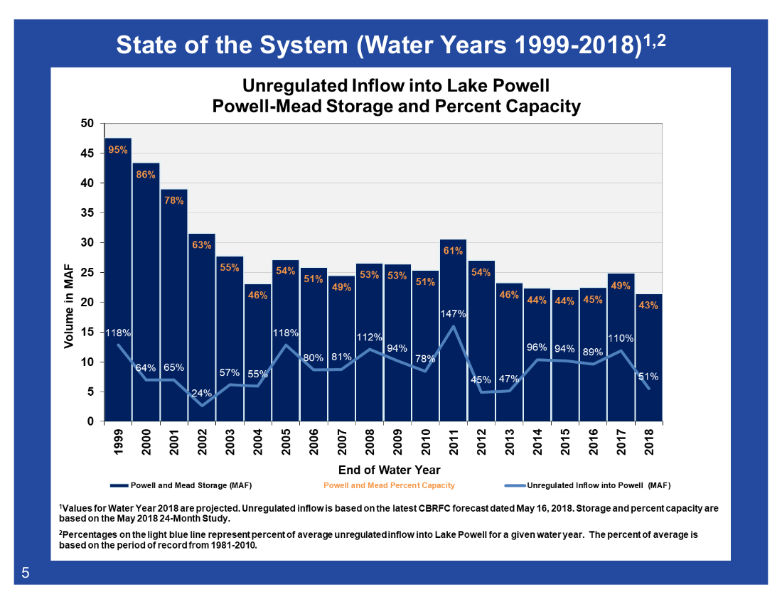
In a slide presentation, Fulp illustrated how the nearly two-decade Southwestern drought has withered water volumes in the Colorado River system, as well as how recent efforts to retain water in Lake Mead have helped stabilize the reservoir, adding nearly 20 feet to its water levels since 2007.
Graphic credit: Terry Fulp/USBR
Arizona water users — including the Central Arizona Water Conservation District and the Gila River Indian Community, among several others – have contributed significantly to those stabilization efforts.
“We have to do more,” said Fulp. “More conservation. More saving.”
Burman’s candid assessment before the IID board mirrored her Bureau’s strongly worded statement, released on May 9, that called for both state and federal action on behalf of the Colorado River basin following the notoriously dry winter of 2017-2018.
Unregulated flow from the Colorado River watershed into Lake Powell this year stands at just 52 percent of average, based on 1981-2010 recorded in-flow records.
“We all – states, tribes, water districts, non-governmental organizations – have an obligation and responsibility to work together to meet the needs of over 40 million people who depend on reliable water and power from the Colorado River,” said Burman in the May 9 press statement.
“I’m calling on the Colorado River basin states to put real – and effective – drought contingency plans in place before the end of this year.”
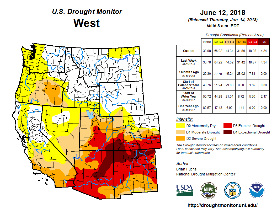
The 416 Fire ten miles north of Durango in southwestern Colorado continues to burn out of control, and the National Wildfire Coordinating Group, which is overseeing efforts to snuff it out, predicts that total containment won’t be achieved until July 31. Moreover, an expert on water throughout this part of the country feels the conditions that have helped fuel this blaze and others in the state (such as the Buffalo Mountain Fire near Silverthorne) could be with us for the foreseeable future.
“We’ve been at one phase of a drought or another over the past seventeen or eighteen years,” notes Bart Miller of Boulder-based Western Resource Advocates. “And many scientists say we’re at a new normal as far as snowpack and drought conditions [go].”
As the director of the Healthy Rivers program for WRA, Miller stresses that fire danger is only one side effect of water shortages in Colorado — a reality exemplified by the early peak of the Colorado River this season.
“Some of the related impacts of when rivers reach their peak are things like low flows and temperature in the water,” he points out. “Low flows usually mean higher temperatures, and that means more stress on fish. Anglers are concerned about what things like that will mean at the end of the summer, when the flows are even lower. And low flows also make it harder for communities to meet their water-quality requirements. If you’re discharging water from a water treatment plant, high flows are good, because they dilute what’s coming out of these facilities. And, of course, higher temperatures and drier soils mean a much more increased chance of fire danger.”
For most communities, Miller acknowledges, “a drier year is not that big of a deal. Many communities have ground water and water storage that can make up for it.” But that’s not the situation in which Colorado and much of the West currently finds itself, as indicated by what’s going on at Lake Powell, which Miller describes as “a storage bucket for the upper Colorado River basin.” As of this week, the Lake Powell Water Database notes that the water level is down 13.69 feet from this time a year ago and is just 53.26 percent of what’s known as “full pool.”
Such scenarios have been all too common in recent decades. The following graphic shows that water levels at Lake Powell have been below average in twelve of the past twenty years.
According to Miller, such figures are even more dire than they seem at first blush.
“When people look at flows or snowpack as compared to average, they usually use the most recent thirty-year average,” he says. “But because the last seventeen or eighteen years or so have mostly been below average, that thirty-year average has dropped. What used to be average is now a lower marker, so the point of measurement is even lower. Something that’s 90 percent of average now used to be 80 or 85 percent of average.”
[…]
Miller offers the following example to illustrate the challenges: “Think about stream regions that have temperature issues, where temperatures get too high for some fish species to exist or that stress the species. As river flow drops, they have to spend more of their time in small pools. So some of the stakeholder groups have tried to figure out if there are things we can do by providing more shade — planting vegetation that will keep the temperatures lower. But the costs are very high. It could be a million dollars a river mile to address these issues on a meaningful scale, and Colorado has thousands upon thousands of river miles. Clearly, we’ve got a big project ahead of us.”
[…]
“Water is the most essential element in Colorado,” he says. “It’s important that we figure out how to secure our future, and that means putting resources toward it: money, people and energy.”
FromThe Glenwood Springs Post Independent (Megan Webber):
Colorado, Utah, Wyoming and northern New Mexico are known as the upper-basin states, nourished by the water from the upper half of the Colorado River before it reaches Lake Powell.
The Colorado River District and other water-conscious groups in the upper-basin states are hoping to formulate a drought contingency plan to sustain Lake Powell. They are looking at three possible solutions.
The first involves releasing water from Flaming Gorge Reservoir, Blue Mesa Reservoir and Navajo Reservoir into Lake Powell, which would keep the levels up for up to two dry years.
If the drought were to last longer than two years after 2018, non-native vegetation could be removed from the river beds to let more water into the river system.
“I would say that the science there is mixed,” [Andy] Mueller said. “It’s not clear that it won’t work, so we’re still doing it, but we need better signs.”
The third possibility involves monitoring the amount of water actively consumed by Colorado and the other three upper-basin states. The extra water would be saved in Lake Powell as insurance for not only the upper-basin states, but also for lower-basin states and Mexico, should the need arise. City water can also be recycled for agriculture and recreation.
The River District is also committed to preserving the aesthetically pleasing areas of Colorado for agricultural and recreational purposes, Mueller said.
In order to preserve the beauty, reduced demand is once again necessary from all over the state. The Front Range sees 450,000 to 600,000 acre feet of water flow through it every year, which feeds cities and fields in eastern Colorado.
“And we feel like they should share the pain, if you will, that they should also reduce their uses over there. If we’re gonna be asked to, they should. Our cities should reduce their use through land-use controls,” Mueller said.
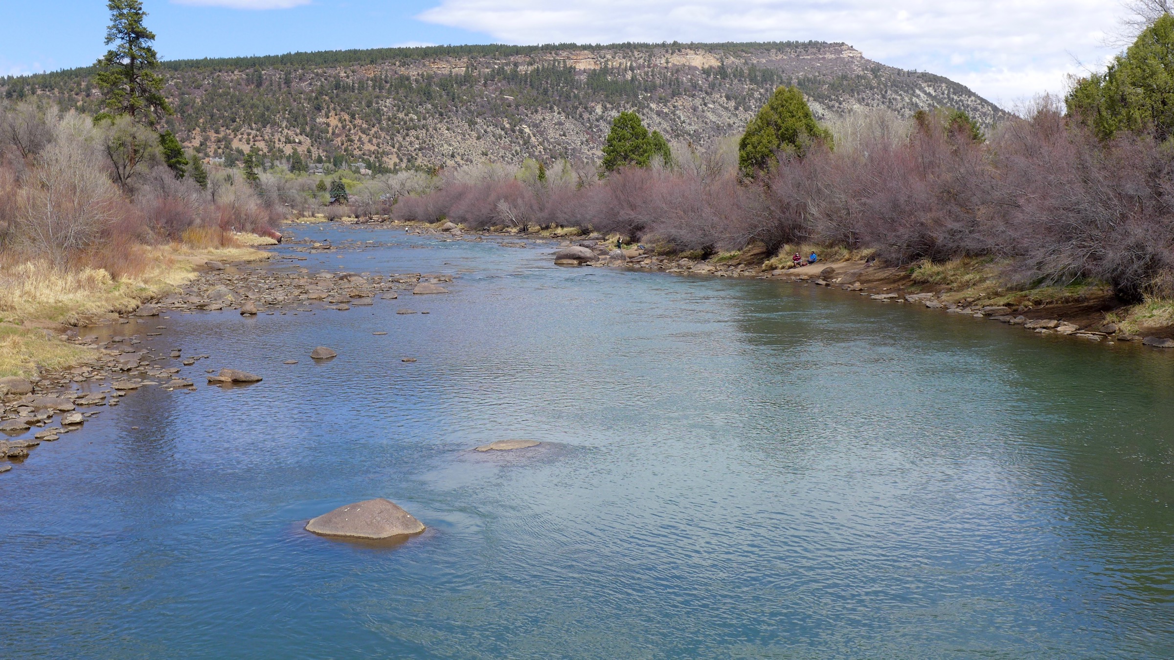
Locally, the Colorado River east of Glenwood Canyon was declared unboatable last weekend.
The Colorado River below the Roaring Fork River confluence dipped below 4,000 cubic feet per second this week, and hovered around 3,200 to 3,400 cfs on Thursday. That’s well below the historical 50-year mean of around 10,300 cfs for this week of June.
In this extremely low spring runoff season, the Colorado at Glenwood Springs at Two Rivers Park peaked at less than 7,000 cfs back in mid-May.
As temperatures rise upstream on the Roaring Fork River in Aspen and Basalt, particularly in July and August, the Parks and Wildlife Commission may prohibit fishing in the area due to overheated waters, which will endanger the fish.
Shoshone Power Plant in Glenwood Canyon is expected to release water on June 20, which will sustain boatable flows throughout Glenwood Springs for the rest of the summer, Mueller said.
Extreme conditions have been expanding northward for several weeks and entered southwest Kiowa county recently. With the latest report, the southern two-thirds of the county moved into extreme drought. The north central part of the county briefly improved to moderate drought but returned to severe conditions this week. Extreme drought also expanded to cover the remainder of Prowers county, and expanded slightly in northeast Crowley county.
Across the rest of the state, conditions were stable. Northeast and north central Colorado have benefitted from spring storms and remained drought-free, while the northwest continues abnormally dry to moderate drought conditions.
The southern one-third of the state remains in extreme to exceptional drought, which has triggered disaster designations by the United States department of Agriculture and Small Business Administration. Assistance to agriculture producers and businesses dependent upon ag is available for a limited time. Assistance is also available to producers impacted by earlier fires, high wind and blizzard conditions.
Overall, 25 percent of the state is drought-free, unchanged from the prior week. Abnormally dry conditions were also unchanged at 11 and 13 percent, respectively. Moderate drought dropped to 16 percent from 17 last week, while extreme drought was up one percent to 27. Exceptional drought was unchanged at eight percent.
One year ago, 94 percent of the state was drought-free, while six percent was abnormally dry.
Rio Grande Silvery Minnow via Wikipedia
FromThe New Mexico Political Report (Laura Paskus):
The Rio Grande has been running far below normal this spring due to drier-than-normal conditions in the mountains this winter. About 20 miles of the river are currently dry south of Albuquerque.
This week, [Middle Rio Grande Conservancy District] told Water Bank participants they can no longer irrigate this spring.
The MRGCD delivers water to about 10,000 irrigators across 70,000 acres between Cochiti dam and Elephant Butte Reservoir. Those irrigators own the water rights and it’s the district’s job to deliver the water through a system of canals and ditches.
The district had also set up a Water Bank so that landowners who sold their pre-1907 water rights could still irrigate their lands when surplus water is available in the system. But when the amount of water stored by the district in upstream reservoirs dipped below a critical threshold last weekend, Water Bank participants were informed deliveries would stop.
Hydrologist David Gensler told MRGCD board members at their regular meeting Monday that the district currently has 92,500 acre feet of water in storage.
“We’re going through our water pretty quickly this spring,” Gensler said, though he noted that they’re ahead of where they thought they’d be due to planning earlier in the year.
“Generally, people are doing all right,” he said, though irrigators might be receiving somewhat less water than they’d like. The best news, he said, is that the forecast for summer monsoons still looks “pretty good.”
MRGCD board member Glen Duggins, an irrigator in Lemitar, followed up Gensler’s comments: “Pray for rain and bale your hay.”
MRGCD Chief Engineer Mike Hamman reported to the board that a coalition—including the district, two federal agencies and the Middle Rio Grande pueblos—agreed to store and move water owned by the pueblos in a way that also ensures the district’s water lasts as long as it can this year. “It’s important that whatever water supply we have, to stretch it out,” Hamman said. He added that this agreement, which he said meets the pueblos’ needs and the irrigation district’s demands, is just for one year…
Rain and supplemental water
Despite “grim discussions” around snowmelt, runoff and the drying river, Jennifer Faler, Albuquerque area manager of the U.S. Bureau Reclamation, told board members that recent rains and agency operations have produced a bounty of silvery minnow eggs this spring. “I just want to remind people that the population can get very, very small, or very, very big in one year,” she said.
Spokeswoman Mary Carlson provided additional information.
Reclamation has already released 8,748 acre-feet of supplemental water for endangered species so far this year. She said the minnows appear to have “responded favorably” to the operational pulses of water by MRGCD and the Albuquerque-Bernalillo County Water Utility Authority, and U.S. Fish and Wildlife Service biologists have been able to collect more than 100,000 eggs to be raised in hatcheries.
“There is no immediate threat of drying in the Albuquerque reach and all water management entities continue to coordinate closely to make every effort to avoid this for as long as possible,” Carlson said. “We are pleased to see more rain in the forecast for this week.”
FromThe Grand Junction Daily Sentinel (Dennis Webb, Erin McIntyre and Wyatt Hurt):
Garfield County commissioners on Monday approved an immediate ban on use of fireworks in the unincorporated part of the county, and Garfield sheriff emergency manager Chris Bornholdt told commissioners the Sheriff’s Office is thinking about imposing Stage 2 fire restrictions as well, which prohibits fireworks, campfires or any open burning of any kind. Smoking outdoors is also outlawed unless it’s in an enclosed vehicle or building.
Ouray County on Monday imposed Stage 2 restrictions, and the Bureau of Land Management likewise has done so for the San Juan County portion of the Gunnison Field Office. Lesser Stage 1 restrictions already in place across much of the region allow fires in designated fire grates in developed campgrounds…
He cited “beyond exceptional” drought conditions in the region, while Bornholdt pointed to four major fires currently burning in the state, including ones in Eagle County and the Durango area.
Meanwhile, the U.S. Forest Service said it would bar most entry to the 1.8 million-acre San Juan National Forest starting today in an effort to keep fires from being ignited due to campfires or other causes there. The forest stretches across southwestern Colorado from just north of Durango to Ouray, and includes the area of the 416 and Burro wildfires that have burned more than 22,000 acres since June 1. The ban doesn’t impact U.S. highways or state or county roads that cross the forest.
While it’s more common for national forests in Arizona and New Mexico to close for fire danger, it’s unusual for this to happen in Colorado, according to Cam Hooley, acting public affairs officer for the San Juan National Forest…
The county’s fireworks ban does not include a ban on sales, whereas such bans have been enacted by Mesa County at the county level and by municipalities. The city of Rifle’s municipal code has a standing open-burn ban from Memorial Day to Labor Day that includes a ban on fireworks sales, possession or use.
Garfield commissioners had imposed a temporary ban on fireworks sales and use in 2013 before agreeing to provide a one-week exemption to the sales portion of the ban around July 4 of that year after a plea from a longtime seasonal fireworks vendor.
Meanwhile, July 4 fireworks shows in Ouray, Glenwood Springs and the New Castle area have been canceled due to the fire danger. Glenwood Springs is planning a laser show instead after the city’s fire chief, Gary Tillotson, urged cancellation of the fireworks show there due to the danger it posed.
Rochelle Firth, office manager for Apple Tree Mobile Home Park, which puts on the annual fireworks show near New Castle, said this year’s show could end up proceeding if drenching rains come before July 4, but she added, “I don’t see that happening.”
[…]
The town of Parachute hasn’t done a fireworks show in the summer for years because of the fire danger, said Town Manager Stuart McArthur. Instead, it puts on a show in the last week in September…
Based on recommendations from the BLM and the Mesa County Sheriff’s Office, Lower Valley Fire Chief Frank Cavaliere said he has recommended to the city of Fruita that it call off its annual July 3 show at Snooks Bottom Open Space…
The decision rests with the Fruita Parks and Recreation Department. Director Ture Nycum said Monday he expects an announcement by the end of the week. Should city officials cancel the show, they’ll announce an alternative celebration, he said. In the past, they’ve sponsored a community barbecue or hosted events downtown…
De Beque Town Manager Lance Stewart said the town won’t make a decision until a day or two before the holiday…
The town has already purchased the fireworks, which puts them in a difficult spot. In the past, when they’ve had to cancel, they’ve done a New Years’ Eve show instead with the fireworks.
Officials with the cities of Grand Junction, Montrose and Delta and the town of Collbran say they plan to light up the July 4 night sky with professional displays, barring drastic changes.
The San Juan National Forest in southwestern Colorado is closed to visitors on Tuesday because of a large wildfire and dry, warm conditions that raise the risk of further blazes. Forests are also closed in Arizona and New Mexico in areas that are suffering from a severe drought…
Fire risks are at “historic levels,” San Juan National Forest Fire Staff Officer Richard Bustamante said, adding, “Under current conditions, one abandoned campfire or spark could cause a catastrophic wildfire, and we are not willing to take that chance with the natural and cultural resources under our protection and care, or with human life and property.”
The San Juan National Forest makes up some 1.8 million acres across nine counties. The full closure, which the Associated Press reports last took place in 2002, does not affect roads that cross through the forest.
In New Mexico, the Santa Fe National Forest was closed days ago “due to extreme fire danger,” the Forest Service said. The area in and around the forest southwest of Santa Fe has seen a string of fires since April.
Farther south, northeast of Albuquerque, extreme fire danger is also forcing parts of the Cibola National Forest to close to the public starting on Friday, New Mexico fire officials said.
The interim plan concentrates on controlling or removing contaminants at 26 sites including campgrounds, mine waste piles, ponds and rivers. It will cost about $10 million and take up to five years, the agency said.
Five of the locations are recreation sites where people could be exposed to arsenic or lead, the agency said.
“EPA is interested in expediting cleanup so that we can show improvements in water quality wherever possible,” said Christina Progess, manager of the Superfund project…
The Gold King is not on the list of 26 sites chosen for interim work. The EPA said that’s because a temporary treatment plant was installed two months after the spill and is cleaning up wastewater from the mine.
The Superfund cleanup will eventually cover 48 mining sites, but the EPA said it chose 26 for interim work to reduce human and environmental risks while a long-term solution is studied.
The EPA said the 26 sites have elevated levels of aluminum, cadmium, copper, iron, lead or zinc.
Two of the recreation sites on the list are campgrounds and three are parking areas or locations where people meet for tours, the EPA said. The plan calls for covering mine waste piles and contaminated soil with gravel or plant growth to reduce human exposure and keep the contaminants from being kicked into the air.
The other work includes dredging contaminated sediment from streams and from ponds near mine openings, and digging ditches and berms to keep water from flushing contaminants out of waste piles and into streams.
The EPA is seeking public comment on the plan. The deadline for comments is July 16.