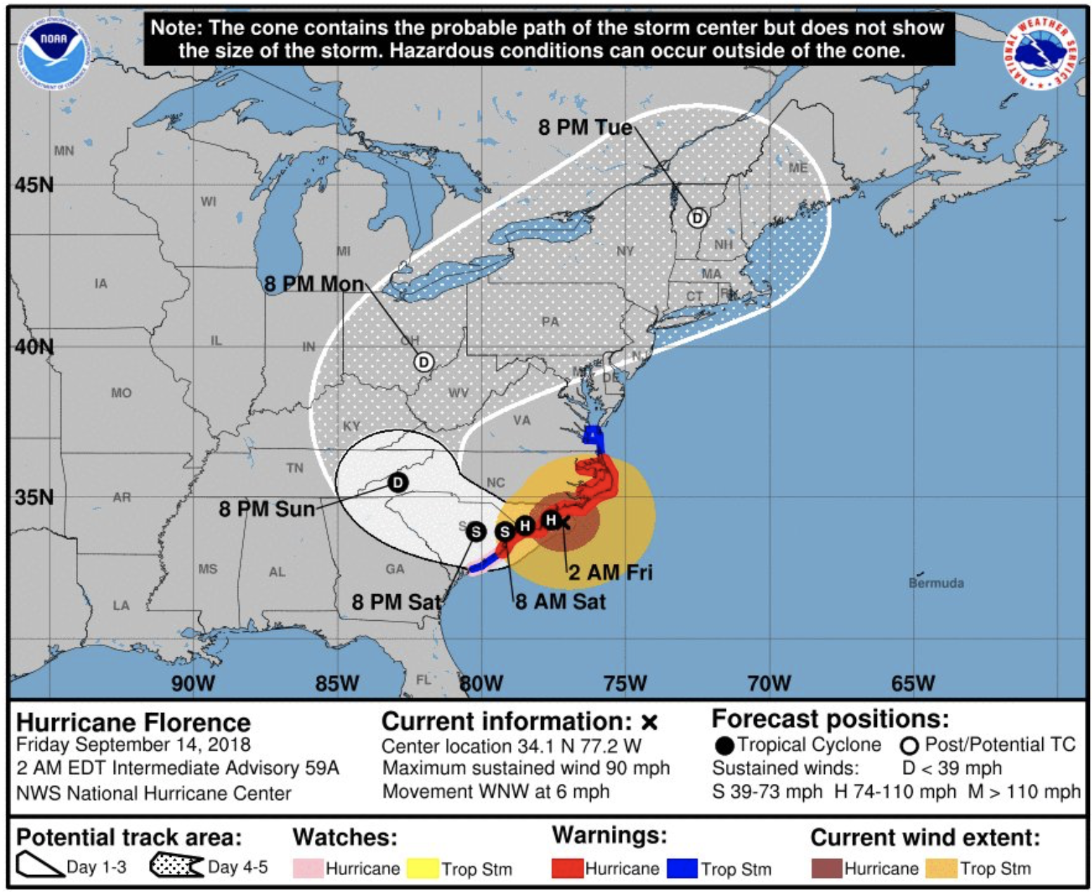
More than a million people are fleeing the Carolina coast ahead of Hurricane Florence’s impending landfall. When they return, the region they call home will likely be forever changed.
Hurricane Florence is an almost impossibly rare threat. A storm this powerful is exceedingly rare this far north on the East Coast. Never before has a hurricane threatened the East Coast with nearly four feet of rainfall. In just two cases since our records began in 1851 — Hazel in 1954 and Hugo in 1989 — has a Carolina hurricane provoked an 18-foot rise in the ocean tide.
In my two decades as a meteorologist, I can’t recall a single storm that threatened new all-time records in all three of these, simultaneously, anywhere in the world. Despite what some of my more hesitant colleagues might say, you can connect individual weather events to climate change in this day and age. Quite simply, Hurricane Florence is a storm made worse by climate change.
A warmer atmosphere can hold more water vapor — producing heavier downpours and providing more energy to hurricanes, boosting their destructive potential. We already have evidence of these trends from around the world. This is no longer just a theory.
The Carolinas are likely to join Texas, Florida, Puerto Rico, California and countless other places worldwide that have experienced such deadly weather over the past 12 months. On Tuesday, the U.S. Geological Survey issued a statement predicting that Florence could erode away protective dunes from three-quarters of North Carolina’s beaches. Like the otherworldly wildfire smoke that dimmed the British Columbia sun last month or the clear-day floods that routinely hit the Marshall Islands, this week’s potentially coastline-erasing landfall is a glimpse into a haunting world that has arrived too soon.
Since modern tracking began, no hurricane with its origins in the hundreds-of-miles-wide patch of the central Atlantic where Florence traveled has ever made landfall on the East Coast, or even come close. Thanks to unusually warm ocean waters, Florence has intensified at one of the fastest rates in recorded history for a hurricane so far north. Thanks in part to unusually warm ocean waters between New England and Greenland, the atmosphere has formed a near-record-strength blocking pattern — not unlike the one that steered Sandy into New York Harbor in 2012 — that is propelling Florence toward the Southeast coastline. Another blocking pattern, expected to emerge later this week over the Great Lakes, could lock Florence in place for days — which would result in an abject freshwater flood that could extend hundreds of miles inland.
For decades, hurricane scientists fretted about when the effects of climate change would become apparent. Tropical meteorology is tricky, and in the past the models have given conflicting results. But on the East Coast, the trends are more clear: Stronger hurricanes are happening more often, and farther north. They are bringing more rain, and — as the seas rise, their coastal floods are literally changing the shape of the coastline.
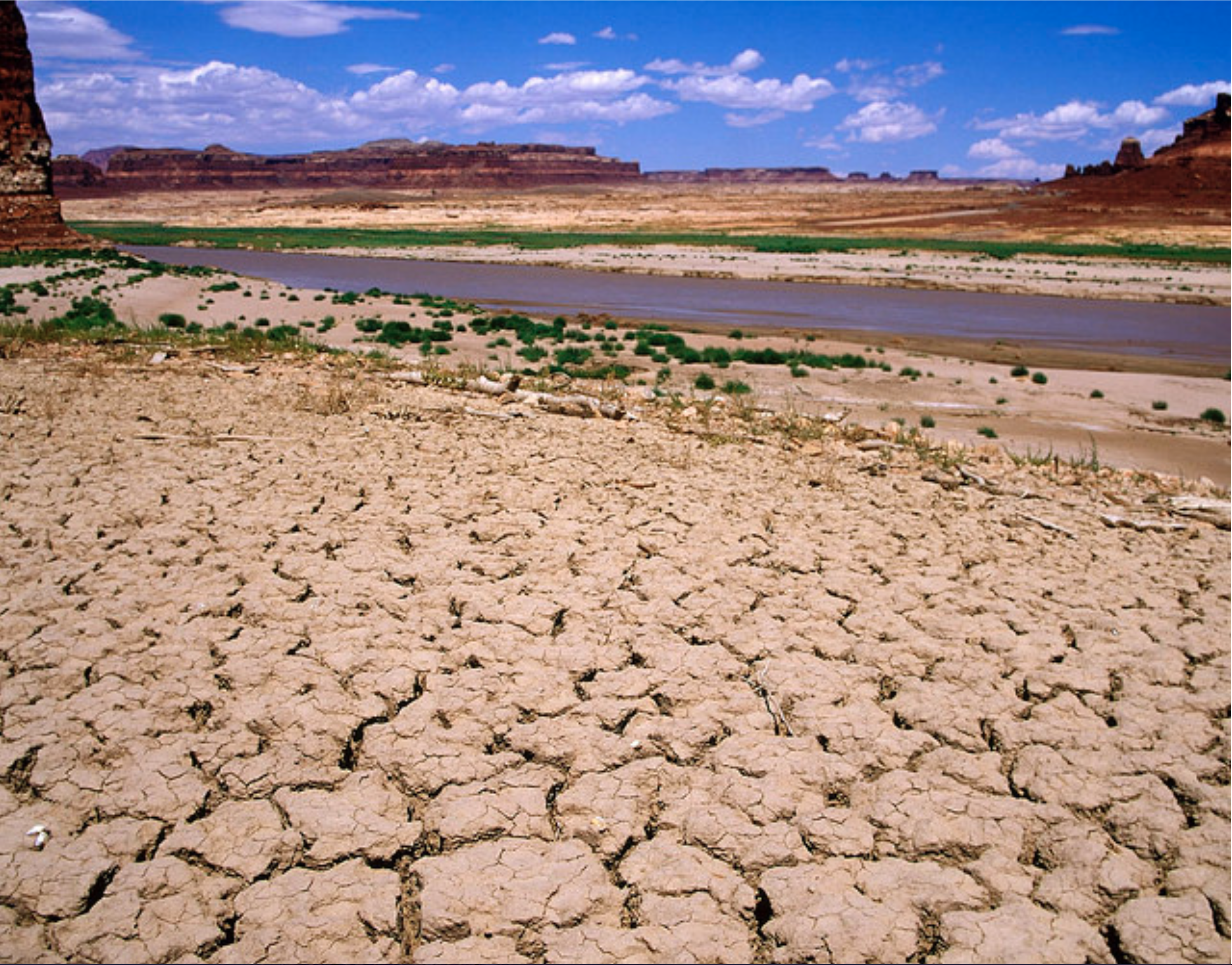
Photo of Lake Powell in extreme drought conditions by Andy Pernick, Bureau of Reclamation, via Flickr creative commons
FromThe Colorado Sun (John Ingold). Click through to read the whole Q&A, here’s an excerpt:
A Q&A with former Colorado Supreme Court Justice Gregory Hobbs, one of the state’s top water experts
Colorado’s system governing water use predates the state itself — the oldest water rights in Colorado date to the 1850s. And it is so closely linked to the state that, even when it is used elsewhere, it is often called the “Colorado Doctrine.”
But can it survive perhaps the greatest challenge in its history — a double-whammy of drought and population growth?
To answer that question, The Colorado Sun sat down with retired state Supreme Court Justice Gregory Hobbs, one of Colorado’s foremost minds on water law. Hobbs has 45 years of experience practicing water law in Colorado, and he continues to serve as a senior water judge and mediator.
First, some background: This spring, an influential water think tank, the Colorado River Research Group, released a report calling on water wonks to stop using the term “drought” to describe what is happening in the West. Drought implies something temporary, the report argued. But these changes show no sign of being temporary.
Greg and Bobbie Hobbs
“For that, perhaps the best available term is aridification, which describes a period of transition to an increasingly water scarce environment,” the group stated in its report.
Meanwhile, the Colorado State Demography Office projects that Colorado will add 3 million people by 2050, bringing the population above 8 million.
This is a worrying prospect for water in Colorado — party to nine interstate water compacts and home to thousands of individual water rights, each meticulously ordered in priority from oldest to youngest. And the strain may already be starting to show.
The fiscal year that ended in June 2017 — the most recent for which data is available — had the most claims and filings in state water court since the similarly parched year of 2012, according to a Colorado Sun analysis. Thornton and [Larimer County] are currently locked in a testy battle over how to move water that Thornton has the rights to out of the Poudre River, lifeblood of Fort Collins. And, according to reporting by Water Education Colorado, a New York hedge fund has spent millions buying up senior water rights on Colorado’s Western Slope — apparently betting on future shortages.
Does Hobbs think the Colorado Doctrine is built to withstand this kind of stress? The following Q&A has been condensed and edited for clarity, readability and brevity. At one point, Rob McCallum, a spokesman for the Colorado Judicial Branch who helped arrange the interview and sat in on it, also chimes in.
Hobbs talks about complicated water compacts and delivery systems as casually as discussing high school memories with an old friend, and it can be hard to keep up. So there are a few Colorado Water 101 explainers sprinkled in to help out.
Gregory Hobbs: The (Colorado River) Compact has really been tested in recent years with sustained drought. But it’s working.
Colorado Sun: At what point does it break?
GH: It doesn’t.
CS: It can’t?
GH: No. Not unless one of the states convinces the other six to renegotiate the compact; it’s perpetual. … Congress could try to override it. But I just don’t see it happening because Congress agreed to the compact.
So this is the essence of state-federal sovereignty, these nine interstate compacts that Colorado is a part of. The alternative is litigating in the U.S. Supreme Court for an allocation. It’s an amazing thing that in this 16-year drought, the target release of 8.25 (million acre-feet per year) out of (Lake) Powell has been met or exceeded.
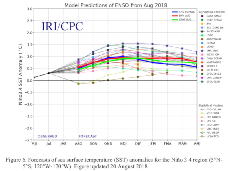
Click here to read the diagnostic discussion from the CPC:
ENSO Alert System Status: El Niño Watch
Synopsis: There is a 50-55% chance of El Niño onset during the Northern Hemisphere fall 2018 (September-November), increasing to 65-70% during winter 2018-19.
ENSO-neutral continued during August, as indicated by a blend of slightly above- and below- average sea surface temperatures (SSTs) across the equatorial Pacific Ocean. Over the last month, the westernmost Niño-4 region was the warmest (latest weekly value was +0.5C), while the Niño-3 and Niño-3.4 regions were weakly positive, with Niño1+2 remaining negative. Subsurface temperature anomalies (averaged across 180°-100°W) were positive, with an increase in above- average subsurface temperatures in the central Pacific and slight expansion of negative anomalies in the eastern Pacific . Convection returned to near average over the Date Line, and was slightly enhanced over Indonesia . Low-level westerly wind anomalies re-developed across the east-central and western Pacific, although they were only slightly evident in the monthly average. Upper-level wind anomalies were westerly over the eastern Pacific. Overall, the oceanic and atmospheric conditions reflected ENSO-neutral.
The majority of models in the IRI/CPC plume continue to predict the onset of El Niño sometime during the Northern Hemisphere fall and continuing through the winter. The forecasters also favor El Niño formation during the fall, and are leaning toward the more conservative model guidance that indicates a weak El Niño event. The persistence of above-average subsurface temperatures and continuing flare-ups of westerly wind anomalies also support the eventual development of El Niño. In summary, there is a 50-55% chance of El Niño onset during the Northern Hemisphere fall 2018 (September-November), increasing to 65-70% during winter 2018-19 (click CPC/IRI consensus forecast for the chance of each outcome for each 3-month period).