Click on a thumbnail graphic to view a gallery of drought data from the US Drought Monitor.
This Week’s Drought Summary
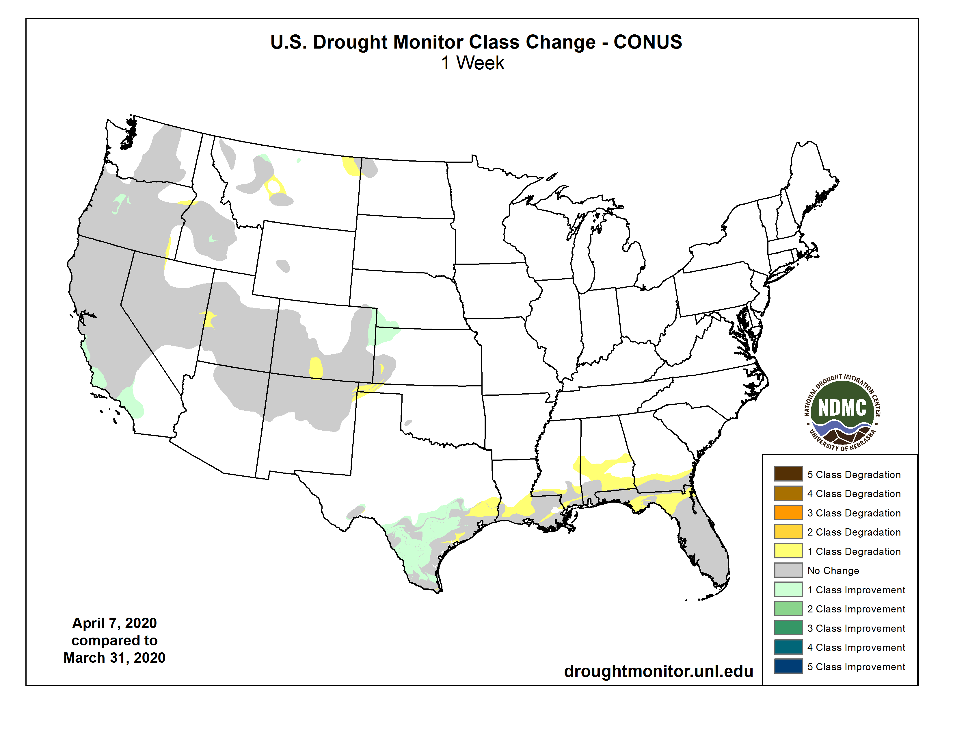
This U.S. Drought Monitor week saw drought expansion across portions of the South (Louisiana, Mississippi) and Southeast (Florida) where warm and dry conditions prevailed during the past 90-day period causing declines in soil moisture and streamflow levels. In Texas, significant rainfall across parts of the state led to improvement in drought-related conditions in South Texas and the Hill Country while areas along the Texas Gulf Coast missed the heavier accumulations. In the northern Plains, record-breaking cold affected the region including eastern portions of Wyoming and Montana. Further West, another series of Pacific storms delivered beneficial rainfall to coastal areas and valley locations in California and Oregon while significant mountain snowfall was observed across the Sierra Nevada, Trinity Mountains of northern California, Cascades, and the northern Rockies. For the month of March, the contiguous U.S. experienced its 30th wettest on record as well as its 10th warmest including record-warmth observed in areas of Texas, Louisiana, Mississippi, Alabama, Georgia, and Florida…
High Plains
On this week’s map, areas of the region—including northeastern Colorado, west-central Kansas, and southwestern Nebraska—saw minor improvements in areas of Abnormally Dry (D0) in response to above-normal precipitation during the past 30-day period. Elsewhere, drought-related conditions deteriorated in southwestern Kansas and south-central Colorado in the San Luis Valley where an area of Severe Drought (D2) was added to the map. In northern portions of the Sangre de Cristo Range, situated on the east side of the San Luis Valley, numerous NRCS SNOTEL observing stations were reporting below-normal, snow-water- equivalent levels (SWE) levels. Elsewhere in the region, average temperatures were well-below normal for the week with numerous locations reporting daily record-low temperatures including Worland, Wyoming which dipped to 2° F on April 3. Interestingly, Worland broke the daily high-temperature record on April 6 soaring to 70° F. For the week, moderate-to-heavy snowfall accumulations were observed across portions of South Dakota, North Dakota, and Wyoming as well as the central Rockies of Colorado. For the month of March, North Dakota experienced its 12th driest on record. According to the NRCS SNOTEL network, basins (6-digit HUC) across Wyoming and Colorado were reporting near-normal to above-normal SWE levels…
West
On this week’s map, recent precipitation events and improving SWE levels led to minor improvements in drought-affected areas of west-central Oregon (areas of D1 and D2) and in south-central Idaho (areas of D2) where snowpack conditions received a needed boost in the Big Lost, Big Wood, and Little Wood basins. In west-central Utah and east-central Nevada, a small area of Moderate Drought (D1) was added in response to short-term dryness during the past 30–90 days. In California, another round of late-spring storms impacted the state delivering beneficial precipitation to the higher elevations of the Sierra Nevada and Trinity Mountains of northern California. In addition, the central California coastal ranges as well as the Transverse Ranges of southern California received rainfall accumulation ranging from 2 to 6 inches leading to removal of areas of Abnormally Dry (D0) from Monterey County southward to San Diego County. As of April 7, the California Cooperative Snow Surveys were reporting the statewide snowpack at 63% of normal with the regional breakdown as follows: North 67%, Central 67%, and South 53%. Elsewhere in the West, the NRCS SNOTEL network is reporting the following region-level (2-digit HUC) SWE levels: Pacific Northwest 110%, Missouri 111%, Upper Colorado 103%, Great Basin 94%, Lower Colorado 105%, Rio Grande 79%, and Arkansas-White-Red 90%. According the NCEI’s climatological rankings, both Arizona and New Mexico experienced their 10th wettest March on record…
South
On this week’s map, drought-affected areas of Texas saw widespread improvements in areas of Moderate (D1), Severe Drought (D2), Extreme Drought (D3), and Exceptional Drought (D4) in response to moderate-to-heavy to rainfall accumulations (ranging from 2-to-5 inches) in South Texas as well as in the Hill Country during the past 7-day period. Drought-stricken areas along much of the Gulf Coast of Texas, however, received accumulations of generally less than one inch. According to the USDA, topsoil moisture in Texas was rated 27% short to very short while Louisiana rated 18% short to very short. In Louisiana and Mississippi, areas of Abnormally Dry (D0) and Moderate Drought (D1) expanded along southern portions in response to another week of warm and dry conditions with numerous streamflow gaging stations reporting 7-day average streamflow levels below the 25th percentile. In the Oklahoma Panhandle, dry conditions persisted this week leading to minor expansion of areas with Abnormally Dry (D0), Moderate Drought (D1), and Severe Drought (D2) ratings. As a region, the South Climate Region experienced its 13th wettest March and 5th warmest…
Looking Ahead
The NWS WPC 7-Day Quantitative Precipitation Forecast (QPF) calls for light-to-moderate accumulations ranging from 1 to 3 inches across portions of the South including Louisiana and Mississippi as well as parts of the Southeast including Alabama, the Florida Panhandle, and Georgia. Along most of the Atlantic Seaboard, accumulations of <2 inches are expected. Elsewhere, the southern half of California is forecasted to continue to receive precipitation (ranging from 1-to-3 inches liquid) while further eastward the central and northern Rockies are expected to receive liquid accumulations of <2 inches. The CPC 6-10-day Outlook calls for a moderate probability of above-normal temperatures in California and western portions of Nevada, Oregon, and Washington as well as Alaska. Likewise, above-normal temperatures are expected in Florida and coastal areas of Georgia and South Carolina with the highest probabilities in southern Florida. For the rest of the continuous U.S., below-normal temperatures are expected. In terms of precipitation, there is a moderate-to-high probability of above-normal precipitation across the eastern third of the U.S. as well as across much of the Southwest extending northward into Colorado, Utah, and Wyoming. In Alaska, above-normal precipitation is expected with probabilities ranging from 33% to 50%. Elsewhere, there is a moderate-to-high probability of below-normal precipitation in northern California, the Pacific Northwest, and the northern Great Basin. In the northern Plains as well as central and western portions of Texas, there is a low-to-moderate probability of below-normal precipitation.
And, here’s the one week change map ending April 7, 2020.