National Bike Month aims to celebrate all that the bike is and can be, and create a movement of people organizing together for better bicycling (albeit, this year it is mostly virtual organization!). Our friends at the League of American Bicyclists say, “Whether you’re riding for fun, fitness or with family, or taking essential trips to work or shop, you are part of our movement for safer streets, connected communities, a healthier planet, and happier people.”
Though most of the country and the Western Slope of Colorado celebrate Bike Month in May each year, the Bike Month celebration is in June for the Colorado central mountains and Front Range. This is when the snow has melted enough for our mountain towns to join the fun!
A monthly surcharge to cus- tomer’s water and wastewater bills was approved by the Pagosa Area Water and Sanitation District (PAWSD) Board of Directors at a regular meeting on May 14.
The monthly surcharge for water is 68 cents per equivalent unit (EU) while the wastewater surcharge is 22 cents per EU, according to PAWSD Manager Justin Ramsey.
This surcharge relates to the PAWSD board previously discussing fee waivers for affordable housing and utilizing those surcharges
to make up for the money lost.
At a regular meeting of PAWSD on Jan. 16, a worksheet was pre- sented that outlined what these fee
waivers would be.
For potential affordable housing developments that are under 60 percent area median income (AMI), PAWSD would be willing to waive 100 percent of its capital investment fees (CIF).
For developments that are 60 to 80 percent AMI, PAWSD would be willing to waive 50 percent of its CIF; for developments that are 81 to 100 percent AMI, PAWSD would be willing to waive 25 percent of its CIF according to the worksheet.
Other than Aspen’s golf course, these fields just up valley from Woody Creek are some of the only areas classified by the state database as irrigated land in the upper Roaring Fork River valley. The City of Aspen is studying opportunities for an Alternative Transfer Method, or ATM, to increase the city’s water supplies by temporarily transferring water from agricultural use. Photo credit: Heather Sackett/Aspen Journalism
The city of Aspen is moving ahead on a project aimed at increasing the reliability of its water supply and environmental flows through what’s known as an “alternative transfer method,” or ATM.
But water managers will have to think outside the box since the usual process of an ATM is transferring water from agricultural to municipal use, and there isn’t much irrigated agriculture in the upper Roaring Fork River basin.
In Colorado, most water rights are held by irrigators. So when towns and cities want to increase their water supplies, they often turn to agriculture to secure extra acre-feet. Permanent water-transfer agreements, often derided as “buy and dry,” can harm agricultural communities and economies, and ATMs are seen as a way to reallocate water more fairly and sustainably from agriculture to municipalities.
These voluntary water-sharing agreements would allow local irrigators to temporarily loan their water to Aspen and get paid for doing so. The most straightforward way for this to happen would be for water-rights holders above the city’s diversions on Castle and Maroon creeks to loan their water to the city.
But according to Colorado’s Decision Support System, which is the state database that tracks irrigated land, there is no irrigated land above Aspen.
“Certainly, the easiest way to meet the most goals is to find water above the city,” said Jason Brothers, principal at Summit Water Engineers, the engineer on the project. “If that’s not available, we will have to look at creative ideas.”
Most of the irrigated acreage in the upper Roaring Fork River valley is grass pasture in the Woody Creek area.
Aspen’s ATM project is funded with a $183,356 grant from the Colorado Water Conservation Board, plus $15,000 each from the city and Western Resource Advocates. It would be the first program designed for a Western Slope headwaters municipality.
In addition to increasing city water supplies, a secondary goal of the project is to improve river flows for the benefit of the environment, especially in the reach of the Roaring Fork through downtown Aspen. In dry years, flows can fall short of the 32 cubic feet per second of water required by the CWCB’s junior instream flow right, which is meant to protect the river environment “to a reasonable degree.”
The 2015 Colorado Water Plan sets a goal of 50,000 acre-feet of water transfers through ATMs by 2030.
“I think that backdrop (of buy and dry) really kind of set the stage for more of a state focus on how do we meet our continuing water-supply needs and can we do that in a way that minimizes harm to ag,” said Alex Funk, agricultural water resources specialist for the CWCB.
According to the grant application, city officials say there are 2,800 irrigated acres in the upper Roaring Fork valley and tributary basins, which the team could explore for compatibility with an ATM program, and that if a third or a quarter of these irrigated lands were in such a program, it could yield 1,000 acre-feet of water.
City officials won’t clarify exactly where those irrigated acres are. The project is still in its infancy and officials don’t have many answers yet, said Steve Hunter, utilities resource manager for Aspen’s water department.
“We just kicked this off,” Hunter said. “I don’t see answers coming for months, if not the latter end of a year into the project.”
Front Range cities take water from the Roaring Fork River basin in a transmountain diversion through the Twin Lakes Tunnel. The city of Aspen is studying the potential for an Alternative Transfer Method, or ATM, to increase its water supplies, which could include approaching transmountain diverters about participating in a water-sharing agreement. Photo credit: Elizabeth Stewart-Severy/Aspen Journalism
Transmountain diverters
One of those creative opportunities Brothers mentioned could involve participation by Front Range water providers that divert water from the headwaters of the Roaring Fork River. The cities of Colorado Springs, Aurora and Pueblo divert water from the upper Roaring Fork through the Independence Pass Transmountain Diversion System via the Twin Lakes Tunnel.
“We are not just looking at in-basin ATMs, but exploring the concept of ATMs on the east slope and if entities would be willing to forego their diversions from the West Slope,” said Todd Doherty, president of Western Water Partnerships. “We are seeing if there’s a willingness between the stakeholders to even consider that.”
Transmountain ATM opportunities are still conceptual at this point, and a water transfer from a transmountain diverter to Aspen would be a break from the way ATMs are typically conducted. However, Funk said the CWCB would be supportive of a municipal-to-municipal transfer of water under the ATM program.
Doherty’s organization is based in Denver and is a Colorado Public Benefit Corporation. The city has contracted with WWP for $213,356 to complete Phase 1 of the ATM investigation, which will entail examining all the water rights that could potentially be available to participate in an ATM program and approaching the holders of those water rights to see whether they are interested. No water-sharing agreement will happen unless the irrigators think it’s a better deal than what they are growing, Doherty said.
“I think it will be a success if we can get a few, hopefully a few larger ones, that will help demonstrate to the other irrigators in the basin that maybe this deal is worth looking at,” Doherty said.
Aspen Journalism is a local, nonprofit and investigative news organization that collaborates with The Aspen Times and other Swift Communications newspapers on coverage of water and rivers. This story ran in the May 29 edition of The Aspen Times.
Fulfilling Drought Contingency Plan commitments and achieving water security for Arizona.
Western Grebes. Photo: William Halladay/Audubon Photography Awards via The National Audubon Society
As part of an overall $38 million effort to bolster Lake Mead surface levels by fallowing irrigable farmland on the Colorado River Indian Reservation in western Arizona, the National Audubon Society has reached an agreement with the Arizona Department of Water Resources (ADWR) to help fund the Colorado River Indian Tribes’ (CRIT) on-going efforts to conserve 150,000 acre-feet of water in Lake Mead over the next three years.
“Leaving water in Lake Mead for the greater Colorado River system creates more security for people and birds in the arid Southwest,” said Karyn Stockdale, Audubon’s Western Water Initiative Senior Director.
“This is a great first step toward completing an important piece of the funding plan approved by the Steering Committee members and the Arizona Legislature,” said ADWR Director Tom Buschatzke. “I commend the National Audubon Society for recognizing the importance of keeping Lake Mead surface levels as stable and healthy as possible.”
The three-year deal is expected to reduce water demand and add approximately two vertical feet to Lake Mead’s surface levels.
According to the agreement signed on May 21, Audubon—supported by their corporate partner Intel Corporation—will contribute to an Arizona Fund created in 2019 to incentivize the CRIT for creating up to 150,000 acre-feet of system conservation water in Lake Mead, helping to avoid precipitous declines in the Lake.
“I want to thank our partners at Audubon, Intel, and the Arizona Department of Water Resources for their ongoing support of this conservation project,” said Colorado River Indian Tribes Chairman Dennis Patch. “The partnership among the State, nonprofit organizations, corporations and our tribal government demonstrates that working together we can tackle the most enduring water supply challenges. The Colorado River Indian Tribes look forward to continuing to work with our partners ensuring the State of Arizona has a sustainable water future.”
The CRIT offered to forego irrigation water deliveries and fallow approximately 10,000 acres of farmland in exchange for the funding.
The fallowing/funding effort is a part of Arizona’s celebrated agreement among dozens of water users, agencies, tribes and conservation groups statewide in January 2019 to address instability in the Colorado River system through the Drought Contingency Plan (DCP). After nearly 20 years of drought in the Colorado River Basin, the DCP is designed to promote conservation, reduce demand, and stabilize water levels in Lake Mead through projects such as the CRIT’s system conservation project.
“Intel is proud to support this vital effort, and to restore water to the community we’ve innovated and invested in for 40 years,” said Liz Shipley, Intel Arizona Public Affairs Director. “Investing in our watershed is an investment in our future.”
Signed May 21, Audubon’s funding contribution agreement with ADWR comes almost exactly one year after the May 20, 2019 signing of the DCP on the Observation Deck of Hoover Dam by the seven Colorado River States and the federal Department of the Interior.
Background on System Conservation and DCP
The months-long, public efforts of Arizona’s Steering Committee, led by ADWR Director Buschatzke and Central Arizona Water Conservation District (CAWCD) General Manager Ted Cooke, opened the door to the State Legislature’s approval of legislation authorizing the ADWR Director to sign the DCP, as well as legislation necessary for the DCP to be implemented in Arizona.
On signing the legislation on January 31, 2019, Governor Doug Ducey hailed the DCP as “the most significant water legislation passed in nearly 40 years.”
The specific terms of the CRIT conservation effort were set out in an agreement by ADWR with the U.S. Bureau of Reclamation, operator of the Colorado River system, and the CAWCD, which delivers about 1.6 million acre-feet of Arizona’s 2.8 million acre-foot annual allocation to users mainly in central and south-central Arizona.
To fund the CRIT creation of system conservation water in Lake Mead, the State of Arizona appropriated $30 million in budget year 2019/2020. By a separate agreement, the Environmental Defense Fund (EDF) agreed to deposit $2 million into the Fund by January 31, 2020 and use its best efforts to raise an additional $6 million into the Fund no later than July 15, 2021.
The Audubon contribution is a part of the EDF agreement. Intel’s leadership support of Audubon made this vital project possible, and also opens up opportunities to leverage additional philanthropic support later this year.
This project demonstrates how the landmark DCP agreement is achieving the goal of creating positive partnerships among entities, fulfilling funding commitments and achieving water security for Arizona.
Here’s an in-depth look at the opening of national parks from Krista Langlois that’s running in National Geographic. Click through for all the photos and graphics. Here’s an excerpt:
Despite these concerns—and questions of whether it’s premature to open parks at all—the Park Service is doing some things right. Rocky Mountain National Park is implementing a “timed entry” system to spread out crowds by giving people a specific time slot when they’re allowed to enter the park. Other parks may follow suit.
Yosemite, which plans to reopen in June, is among a number of parks limiting visitors to roughly half its typical capacity. Yellowstone has spent $135,000 on sanitation, protective gear, and educational signs. The Park Service is distributing masks and gloves to employees, albeit unevenly, and trying to educate visitors on safe practices: staying six feet apart, choosing parks close to home, and avoiding traveling long distances to get to a park.
(Related: Trespassing and vandalism abound at national parks that remain open during the pandemic.)
Some parks, like Yosemite, remain closed, while others were relatively quiet over Memorial Day weekend. A visitor from Big Cypress National Preserve in Florida said the park was practically empty, perhaps because of rain. A hiker in Washington’s Olympic National Park, where many roads remained closed, reported seeing few crowds. A ranger at Virginia’s George Washington Memorial Parkway, which connects trails around Washington, D.C. and is administered by the Park Service, said that the people he saw hiking were mostly in small groups spaced well apart.
Still, some parks just aren’t set up for social distancing. It’s nearly impossible to stay six feet apart on the boardwalks around Yellowstone’s geysers, for example, or the narrow hiking trails in Zion. That means that the responsibility to stay safe falls both to parks and individual travelers. “It’s really important for visitors to go online and check the park’s website before they go so they can make sure they’re prepared,” Brengel said. “If a park is going to be too crowded or a trail is closed, they should have a plan B.”
Having a backup plan—such as visiting a less-busy national forest—is one of the recommendations of the new #RecreateResponsibly initiative, a collaboration between nonprofits, outdoor businesses, and land managers. Other recommendations include adventuring with members of your household; choosing low-risk activities to decrease the chances of needing already-strained emergency services, such as hiking instead of rock climbing; and being self-sufficient, such as packing your own lunch instead of counting on a park restaurant to be open. The #RecreateResponsibly initiative emphasizes staying close to home, because non-essential travel is still discouraged by the nation’s top health officials.
Gold is everywhere in modern life, from jewelry to electronics to smartphones. The global electronics industry alone uses 280 tons annually. And that demand keeps growing.
But most people know little about the environmental impacts of gold mining. About 15% of world gold production is from artisanal and small-scale mining in over 70 countries throughout Asia, Africa and South America. These operations employ 10 to 19 million workers. They often are poorly policed and weakly regulated.
Artisanal mining might sound quaint, but it is usually criminal activity and results in widespread environmental damage. It also is the largest source of mercury pollution in the world today, far exceeding other activities such as coal combustion and cement manufacturing. While mercury is an element that occurs naturally in the Earth’s crust, it has many toxic effects on humans and animals, even at very low exposure levels.
We have studied mercury pollution from artisanal gold mining for the past five years. The extraction methods that these operations use today are not drastically different from processes that miners employed in the California gold rush in the mid-1800s. Today we see history repeating itself in places like the Peruvian Amazon, where small-scale gold mining threatens to leave behind long-lasting social, economic and environmental consequences.
Mercury contamination from gold mining
Mercury has been used for centuries as an inexpensive and easy way to collect gold. The process begins when miners pump a mixture of water and sediment from a riverbed into a trough, where the sediment can be suspended into a slurry – a technique known as hydraulic mining.
Next they add mercury, which binds to the gold particles, forming an amalgam. Mercury is heavier than pure gold, so the balls of amalgam sink to the bottom of buckets or holding ponds where they can be collected. Finally, workers burn off the mercury – often with a hand torch or in a crude stove – leaving gold metal behind.
This process releases mercury to the environment in two forms. First, tailings, or waste material, can contaminate nearby land and aquatic ecosystems. Second, mercury vapor enters the atmosphere and can travel long distances before being deposited to land and water via rainfall or small dust particles.
In the environment, microbes can transform mercury into a more potent form known as methylmercury. Methylmercury can be taken up by bacteria, plankton and other microorganisms that are then consumed by fish and build up to dangerous concentrations in animals higher on the food chain.
When artisanal gold miners burn mercury, it is released into the atmosphere and can end up on land or in water. Mining tailings (solid waste) also deposit mercury onto land or into water. Microbes in the environment can convert mercury into methylmercury, which can be taken up by living organisms, including fish and people. Arianna Agostini, Rand Alotaibi, Arabella Chen, Annie Lee, Fernanda Machicao, Melissa Marchese, CC BY-ND
Methylmercury is a potent neurotoxin that is harmful to humans and wildlife, such as endangered giant otters that feed high on the food web within these contaminated environments. It can cause severe central nervous system damage that results in sensory and motor deficits, as well as behavioral impairments such as difficulty swimming in aquatic animals and flying in birds.
A lasting legacy in California
During the U.S. gold rush, hydraulic mining operations in California completely denuded forested landscapes, altered the course of rivers, increased sedimentation that clogged river beds and lakes and released enormous amounts of mercury onto the landscape. California wildcat miners used an estimated 10 million pounds of mercury from the 1860s through the early 1900s. Most of it was released to the environment as tailings and mercury vapor.
A century later, water, soil and sediments in the Sierra Nevada region still have high concentrations of mercury and methylmercury, often exceeding thresholds set by the U.S. Environmental Protection Agency. Studies show that fish, birds and other organisms living near historically mined sites in California have high mercury concentrations in their bodies compared to those inhabiting nearby unmined landscapes. Extreme erosion on mountain slopes can continuously mobilize mercury deposited decades ago.
History repeats itself
Like men who traveled to California in 1849 hoping to strike it rich, today’s artisanal miners around the world are mainly low-skilled workers hoping to support themselves and their families.
In Peru, where we have studied this process, artisanal miners produce an estimated 35,000 to 40,000 pounds of gold per year. The industry offers an opportunity for upward mobility for substantial numbers of Peruvians, who generally migrate to mining sites from coastal and mountain towns.
As a result, gold rush towns have boomed over the past 20 years. The Inter-Oceanic Highway, which was completed in 2012 and runs from Brazil’s Atlantic coast to Peru’s Pacific coast, has connected these towns to larger cities and increased access to the Peruvian Amazon.
Producing a pound of gold requires about 6 pounds of mercury. Given that at least 50% of the mercury used in these operations is lost to the environment, we estimate that artisanal gold mining in Peru alone releases nearly 50,000 pounds of mercury annually.
Mining in this region is producing impacts that are strikingly similar to the hallmarks of the California gold rush. For example, miners in the Peruvian Amazon have cleared more than 250,000 acres of forest since 1984.
The Madre de Dios River, which runs through a zone that has seen substantial mining, will likely continue to erode the landscape, carrying mercury-laden particles downstream. Long-lasting mercury contamination in this region threatens the highest biodiversity on the planet and many indigenous communities.
Comparison of landscape change from gold mining during the California gold rush (left) and modern artisanal mining in Peru (right). Bancroft Library, UC Berkeley (left); Arabella Chen (right)
Gold mining in 19th-century California sparked a wave of western migration and helped drive settlement of what we now refer to as the western United States at a time when mining and environmental pollution were unregulated. Today, use of mercury in artisanal gold mining is regulated by the 2013 Minamata Convention on Mercury, which has been signed by 128 countries – including Peru. Yet there is little on-the-ground regulation in most countries. Nor have governments addressed legacy pollution and deforestation from gold mining.
Illegal artisanal gold mining is a major source of income for local communities in places like the Madre de Dios region of Peru. As long as people all over the world continue to demand more gold, we believe that they are just as responsible as miners and local policymakers for the environmental degradation gold mining causes.
(May 17) projects April – July unregulated inflows into Lake Powell to be 61% of average, down from 74% of average forecast on April 17. Other spring reservoir inflow forecasts in the discussion include Fontenelle (88% average), Flaming Gorge (84% of average), Blue Mesa Reservoir (59% of average), McPhee Reservoir (35% of average), and Navajo Reservoir (50% of average). All forecasts are lower than last month, in some cases significantly lower.
(May 17) projects April – July unregulated inflows into Lake Powell to be 61% of average, down from 74% of average forecast on April 17. Other spring reservoir inflow forecasts in the discussion include Fontenelle (88% average), Flaming Gorge (84% of average), Blue Mesa Reservoir (59% of average), McPhee Reservoir (35% of average), and Navajo Reservoir (50% of average). All forecasts are lower than last month, in some cases significantly lower.
For information on what the forecast means for the water supply and reservoir operations in the Colorado and Gunnison basins in Colorado, you can review video and access presentation slides from the Mesa County State of the River webinar hosted by the Colorado River District and Hutchins Water Center, as well as the District’s other State of the River webinars.
Click here to read the current assessment. Click here to go to the NIDIS website hosted by the Colorado Climate Center. Here’s the summary for this week:
Summary: May 26, 2020
The previous week’s weather was true to early summer form over the Intermountain West. The Colorado River watershed stayed dry save for the far northern reaches of the Upper Green Basin. Areas east of the Continental Divide received several rounds of showers, amounting to 0.50-1.00″ of moisture. Isolated severe storms struck southeast Colorado last Tuesday and Thursday, the 19th and 21st. More widespread moisture hit eastern Colorado on Sunday the 24th. Temperatures stayed cooler than normal for the Upper Colorado River Basin, but it was a warm week for the Eastern Plains, with temperatures anywhere from 2-8 degrees above normal.
While the Arapahoe Basin Ski Resort is reopening, this move is not reflective of the broader snowpack scenario. Northern basins, such as the South Platte and Yampa/White watersheds, are holding onto normal snowpack for this time of year. Over 90% of the season’s peak snowpack has already melted from SNOTEL measurement sites in the San Juan and Rio Grande Basins. As we reach peak streamflow season, we are seeing a mix of above and below normal flows. Streamflows are below normal on the San Juan and Gunnison River Channels. This is troubling, since these areas have nearly no snowpack remaining at SNOTEL sites. Reservoir storage is falling into the below normal range in southwest Colorado as well.
While recent moisture in eastern Colorado is helpful, long-term drought indicators, and vegetative health indices are still paining a grim picture over much of the region. The Vegetative Drought Response Index is showing moderate-to-severe drought conditions across all of southern and eastern Colorado, all of northern and central Utah, and now, much of Wyoming as well. Field condition reports are also discouraging, particularly in areas where severe drought already exists. Impacts include dry soils, lack of green vegetation, inability to drill and plant crops, and cattle being taken to auction early.
The seven-day precipitation outlook shows some shots for moisture mainly over the high terrain. This moisture will come in the form of thunderstorms. Temperatures are forecasted to be well above normal as high pressure air builds over the region. Both medium and long-range outlooks suggest increased chances for above normal temperatures across the region with less certainty with regards to precipitation.
Here’s the release from the USDA (Shawn Reinhardt):
U.S. Department of Agriculture (USDA) Deputy Under Secretary for Rural Development Bette Brand today announced that the department is investing $281 million in 106 projects to improve water and wastewater infrastructure in rural communities in 36 states and Puerto Rico. USDA is funding the projects through the Water and Waste Disposal Loan and Grant program.
“These investments will bring modern, reliable water and wastewater infrastructure to rural communities. They will replace deteriorating, leaking water pipes with new ones and upgrade water handling systems that are decades old. These investments create jobs and improve public health and safety for our rural neighbors,” Brand said. “Under the leadership of President Trump and Agriculture Secretary Perdue, USDA is committed to partnering with rural communities to help them improve their infrastructure, because when rural America thrives, all of America thrives.”
USDA is funding projects in Alabama, Arkansas, California, Colorado, Georgia, Iowa, Illinois, Indiana, Kansas, Kentucky, Louisiana, Maine, Massachusetts, Michigan, Minnesota, Missouri, Mississippi, Montana, Nebraska, New York, North Carolina, North Dakota, Ohio, Oklahoma, Oregon, Pennsylvania, Puerto Rico, South Carolina, South Dakota, Tennessee, Texas, Utah, Virginia, Washington, West Virginia, Wisconsin and Wyoming.
Eligible applicants include rural cities, towns and water districts. The funds can be used for drinking water, stormwater drainage and waste disposal systems in rural communities that meet population limits.
Below are examples of water and wastewater projects in rural communities that will receive funding:
The city of Mabton, Wash., will use a $677,000 loan and a $296,195 grant to drill a new well. The city owns and operates a domestic water system that serves 632 active, metered connections. Ground water is currently pumped from two wells, delivered to an 800,000-gallon reservoir, treated by chlorination for disinfection and distributed to customers. The new well will augment water capacity, resulting in improved reliability.
The city of Auburn, Ky., will use a $6.1 million loan and a $2.6 million grant to replace the wastewater treatment plant to accommodate increased discharge from a new industrial facility. The expanded treatment plant will continue to provide safe and reliable wastewater treatment services for customers in rural Logan County while expanding capacity for economic development.
In Terlton, Okla., Pawnee County Rural Water District #2 will use a $1.7 million loan and a $597,000 grant to rehabilitate wells and bring the water treatment plant up to Oklahoma Department of Environmental Quality standards. These improvements will enable the district to reduce the amount of water it is required to purchase. This will help lower operating expenses and increase the efficiency and sustainability of the system. The district provides water to 2,174 rural residents.
In April 2017, [the administration] established the Interagency Task Force on Agriculture and Rural Prosperity to identify legislative, regulatory and policy changes that could promote agriculture and prosperity in rural communities. In January 2018, Secretary Perdue presented the Task Force’s findings to President Trump. These findings included 31 recommendations to align the federal government with state, local and tribal governments to take advantage of opportunities that exist in rural America. Increasing investments in rural infrastructure is a key recommendation of the task force.
USDA Rural Development provides loans and grants to help expand economic opportunities and create jobs in rural areas. This assistance supports infrastructure improvements; business development; housing; community facilities such as schools, public safety and health care; and high-speed internet access in rural areas. For more information, visit http://www.rd.usda.gov.
PFAS contamination in the U.S. via ewg.org. [Click the map to go to the website.]
FromColorado Politics (Marianne Goodland) via The Colorado Springs Gazette:
A bill on toxic firefighting chemicals that have contaminated water supplies in southern El Paso County won unanimous support Thursday from the House Finance Committee.
[HB20-1119] was approved by the House Energy and Environment Committee on March 9, before the General Assembly shut down for 10 weeks due to the novel coronavirus pandemic.
According to bill co-sponsor Rep. Lois Landgraf, a Colorado Springs Republican, the measure is a fix of sorts for legislation that passed in 2019 which banned the use of perfluoroalkyl and polyfluoroalkyl chemicals, known collectively as PFAS.
Widefield aquifer via the Colorado Water Institute.
The 2019 law banned Class B firefighting foams that contain “intentionally added” per- and polyfluoroalkyl substances. Those chemicals were used for decades at Peterson Air Force Base in El Paso County and have been found in the Widefield aquifer, which serves Security, Widefield and Fountain, communities near the base…
Last year’s bill created the clean water process for PFAS, Landgraf said. “What we didn’t realize is that it also eliminated the ability of the airports to stay in business. United could not get their insurance because we banned any use of PFAS. They have to practice with it a couple of times every year to keep their insurance in place,” Landgraf said.
This year’s measure allows the testing to take place in airline hangars. The runoff will be captured in catch basins and then disposed of.
The bill also requires a the state’s solid and hazardous waste commission to come up with a certificate for any facility — like an airport — or firefighting department that shows PFAS is present on the premises.
Landgraf said the certificate will help the state track PFAS. “Right now we don’t know who’s using it and not using it,” she said.
The Colorado Aviation Association backs the bill in its current form, according to lobbyist Kelly Sloan, who pointed out that the use of PFAS is on its way out. The Federal Aviation Administration is planning to phase out the use of PFAS at airports, but for now, airports still have to comply with those federal regulations, he said…
The bill now heads to the House Appropriations Committee.
Click on a thumbnail graphic to view a gallery of drought data from the US Drought Monitor.
US Drought Monitor May 26, 2020.
West Drought Monitor May 26, 2020.
Colorado Drought Monitor May 26, 2020.
Click here to go to the US Drought Monitor website. Here’s an excerpt:
This Week’s Drought Summary
During the past week, widespread rain and thunderstorms fell across parts of the Great Plains, including a few instances of severe weather. Particularly large amounts of rain in central and eastern Nebraska, as well as in adjacent states, improved what had been a quickly drying scenario in many locations. Above-normal precipitation also fell in parts of the Northwest, which led to improvement in parts (though not all) of the ongoing drought areas there. Large rainfall amounts also occurred in south Florida and in parts of the central Florida Panhandle, leading to improvements in or removal of drought in these locations. Widespread rain in parts of Texas also led to drought improvement in the state, though some areas that missed out on the rain (particularly in the Panhandle) saw conditions worsen. Moderate and severe drought were also added to parts of Molokai and the Big Island in Hawaii. Moderate drought coverage lessened in southern Louisiana after precipitation fell there…
As several slow-moving low pressure systems crossed the region this week and weekend, areas of rain and thunderstorms were common, excluding northeast South Dakota, eastern North Dakota, and parts of the southeast Colorado high plains. Temperatures were quite variable across the region, but were generally lowest (2 to 4 degrees cooler than normal) in central Kansas and south-central Nebraska, and warmest in South Dakota and North Dakota, the latter of which had widespread temperatures from 6 to 8 degrees warmer than normal. Rain from a cluster of thunderstorms on Thursday in southwest Kansas prevented conditions from worsening there, though southwest Kansas and adjacent eastern Colorado remain very dry, and moderate, severe, and extreme drought persisted across parts of these areas. Extreme drought lessened in coverage in part of eastern Colorado due to recent rainfall and lessened short-term precipitation deficits. In northern Kansas and Nebraska, heavy rain from a series of slow-moving storm systems improved what had been abnormally dry conditions in some areas. Short-term moderate drought persisted this week in southwest North Dakota and far northwest South Dakota…
Precipitation fell this week across much of Montana (excluding southwest Montana), Idaho, eastern Oregon, parts of Washington, central and northeast Nevada, northern Utah, northwest Wyoming, central Colorado, and parts of eastern Wyoming. New Mexico was mostly dry this week, aside from a bit of rain across the far northeastern high plains. Warmer than normal temperatures could be found in coastal California, but otherwise, below-normal temperatures were common across the Intermountain West. In western Utah, severe drought expanded westward as a result of worsened short- and long-term precipitation deficits. Severe drought expanded northward in central Idaho, where streamflow had become very low in the Big Lost River area. Farther northwest in Idaho, and in adjacent parts of northeast Oregon and southeast Washington, recent precipitation resulted in lessened precipitation deficits and improved streamflow, leading to improvements in drought conditions and abnormal dryness in these areas. Recent precipitation also led to the removal of moderate drought in northwest Montana. Areas of southwest Montana and adjacent northeast Idaho that missed out on the larger precipitation amounts this week slipped into moderate drought as a result of growing short- and long-term precipitation deficits. Severe drought was added to the map in southeast Oregon, where short- and long-term precipitation deficits continued to grow. Growing precipitation deficits over the water year and lessening streamflow led to the extension of moderate drought in a small part of north-central Oregon and adjacent south-central Washington. Recent precipitation led to a slight reduction in coverage of moderate and severe drought in western Oregon. Moderate drought coverage increased in eastern New Mexico due to increasing short-term precipitation deficits and high evaporative demand…
Widespread precipitation fell this week across parts of central and north Texas, including parts of the Texas Panhandle. Widespread rain also fell in Oklahoma, though this missed the western part of the Oklahoma Panhandle. Rain also fell over much of Arkansas (excluding far southeast), much of Louisiana (though generally excluding the immediate Gulf Coast), and southeast Mississippi. Heavier rain (2-3 inches) also occurred in eastern Tennessee this week, although eastern Kentucky received greater amounts. Moderate drought conditions improved in parts of south-central Louisiana, where soil moisture and short-term precipitation deficits had lessened. Drought conditions improved in parts of Texas where rainfall this week lessened short-term deficits, while many areas that missed the higher rainfall amounts worsened, particularly in the drier parts of the Texas Panhandle. In Oklahoma, parts of western Oklahoma and the Panhandle that received more rainfall had improvements. However, rainfall missed the western Oklahoma Panhandle, where severe drought continues, and precipitation deficits on both short- and long-term scales have continued to worsen here…
Looking Ahead
During the first week of June, the National Weather Service Climate Prediction Center is forecasting a high probability of warmer than normal temperatures across most of the continental United States (excluding the East Coast, south Texas, and the Pacific Northwest). The highest probability for above-normal temperatures is centered on the Central Great Plains. The Intermountain West, in particular the Four Corners, northwest Nevada, and southeast Oregon, are favored to have above-normal precipitation, while areas close to the Canadian border (to the west of Lake Huron) are also slightly favored for above-normal precipitation. Meanwhile, most areas from the central and southern Great Plains to the Atlantic Seaboard are favored to have below-normal precipitation, with the exceptions of south Florida and south Texas.
US Drought Monitor one week change map ending May 26, 2020.
FromThe Denver Post (Bruce Finley) via The Broomfield Enterprise:
Company officials say tests show contaminants did not exceed state standards for surface water
Contaminated water has been seeping into Sand Creek just up from where it meets the South Platte River near the Suncor Energy oil refinery north of Denver, and company officials on Wednesday said they were monitoring conditions and “will make any necessary repairs” to a spill containment pool behind sandbags where crews were pumping out water.
A sheen of benzene and other chemicals was detected on the surface of Sand Creek on May 7 and again on May 15, company officials said.
Sunday’s heavy rains raised water levels along the creek, leading to a breach of the containment area.
Suncor contractors have drawn water samples from Sand Creek and the South Platte, and tested these for benzene, toluene, ethylbenzene, xylene and methyl tertiary butyl ether, company officials said. The results showed concentrations did not exceed state standards for surface water in those waterways, officials said.
Colorado Department of Public Health and Environment officials did not respond to queries about conditions at the refinery. It is located just north of Denver in Commerce City, along the creek and the Sand Creek Greenway public bicycle path, near where the creek flows into the South Platte.
“Who is watching this?” Adams County Commissioner Steve O’Dorisio said. “I’m concerned about the problems that continue to occur.”
Denver’s Brown Cloud via the Denver Regional Council of Governments.
Here’s the release from Phil Weiser’s office (Lawrence Pacheco):
Attorney General Phil Weiser today joined a multistate coalition in filing a lawsuit challenging the federal government’s final rule rolling back the national clean car standards.
“The administration’s illegal rollback rejects sound science, ignores environmental harms caused by carbon pollution, and will cost consumers more at the pump. Colorado is joining this lawsuit challenging the administration’s illegal action in order to defend our state’s fuel emission standards that are stronger than the national standards,” Weiser said. “By making more zero-emission vehicles available to Coloradans, we can address climate change and protect our air quality.”
In 2010, the EPA, states and automakers established a unified national program harmonizing improvements in fuel economy and reductions in greenhouse gas emissions from passenger cars and light trucks and then applied those standards to vehicle model years 2017-2025. The administration took its first step toward dismantling the national clean car standards in 2018, alleging that the standards were no longer appropriate or feasible despite the fact that the auto industry was on track to meet them.
On March 31, 2020, the EPA announced its final rule rolling back the clean car standards. The rule takes aim at the corporate average fuel efficiency standards, requiring automakers to make only minimal improvements to fuel economy on the order of 1.5 percent annually instead of the previously anticipated annual increase of 5 percent. The rule also diminishes the requirements to reduce vehicles’ greenhouse gas emissions, allowing hundreds of millions of metric tons of avoidable carbon emissions into our atmosphere over the next decade.
In the lawsuit filed today, the coalition argues that the final rule unlawfully violates the Clean Air Act, the Energy Policy and Conservation Act, and the Administrative Procedure Act.
Attorney General Weiser joins the attorneys general of California, Connecticut, Delaware, Hawaii, Illinois, Maine, Maryland, Massachusetts, Michigan, Minnesota, Nevada, New Jersey, New Mexico, New York, North Carolina, Oregon, Pennsylvania, Rhode Island, Vermont, Virginia, Washington, Wisconsin, and the District of Columbia. The California Air Resources Board and the Cities of Los Angeles, New York, San Francisco, and Denver also joined the coalition in filing the lawsuit.
FromThe Denver Post (Bruce Finley) via The Broomfield Enterprise:
Led by California, the states and major cities — including Denver — have asked federal judges to reverse Trump’s Safer Affordable Fuel Efficient Vehicle Rule, which was finalized in March and loosened requirements set under the Obama administration to make cars and light pickup trucks about 5% more efficient each year.
Trump’s rule means vehicles over the next decade would emit hundreds of millions more tons of carbon dioxide and other heat-trapping gases into the atmosphere. Instead of making cars that can cover 54 miles per gallon by 2025, automakers could make cars that cover 40 mpg by 2026.
Federal officials argue this will make new cars more affordable, encouraging more Americans to upgrade to relatively cleaner cars.
This lawsuit, filed in the U.S. Court of Appeals for the District of Columbia Circuit, contends the Trump rule violates the Clean Air Act, the Energy Policy and Conservation Act, and the Administrative Procedure Act.
“We so depend on protecting our land, air and water for our lifestyle,” Weiser said in a conference call Wednesday with attorneys general Xavier Becerra of California and Dana Nessel of Michigan.
“Climate change is not a theoretical, looming challenge. It is there today,” Weiser said, referring to “less natural snowpack than ever before” and a growing burden on future generations to deal with climate change impacts.
He cited a U.S. Supreme Court case that, more than a decade ago, established EPA power to regulate pollution that causes climate change.
“It is the job of the courts to get the EPA on track,” Weiser said.
Denver Mayor Michael Hancock, in a prepared statement, noted that vehicle emissions are a top contributor to air pollution over the city and are fueling climate change — causing harm to the public’s health and prosperity.
“If these rules are rolled back, the Trump administration will negate the progress that has happened across the country in these areas during a critical point in history,” Hancock said. “We are past due for our country taking more meaningful action, which is why Denver joined this important lawsuit.”
In 2010, EPA officials, state leaders and automakers began working to improve vehicle fuel efficiency and reduce emissions of heat-trapping gases and other pollution from passenger cars and light trucks made after 2017. Automakers have been working to meet these standards. Since 2018, Trump administration officials have been saying the standards are inappropriate and no longer feasible.
Rush hour on Interstate 25 near Alameda. Screen shot The Denver Post March 9, 2017.
Here’s a release about a coalition that has also filed a lawsuit from Environment Colorado (Ellen Montgomery, Hannah Collazo, Mark Morgenstein):
Environment America, an affiliate of Environment Colorado, along with ten other public interest organizations, filed a lawsuit today in the U.S. Court of Appeals for the D.C. Circuit opposing the Trump administration’s action to weaken federal clean car standards. This lawsuit follows litigation that Environment America and the other public interest groups previously filed challenging part one of the action, which attempts to block California and other states from setting stronger tailpipe emissions standards.
The petition challenges a final rule issued jointly by the Environmental Protection Agency (EPA) and the Department of Transportation’s National Highway Traffic Safety Administration (NHTSA). The agencies’ action violates several federal statutes, including the Energy Policy and Conservation Act, the Clean Air Act, and the Administrative Procedure Act.
“The EPA’s own analysis shows that this will reverse climate progress. The clean car standards should protect our climate, our health and the future of our children and grandchildren,” said Hannah Collazo, State Director with Environment Colorado. “This plan is unacceptable. Not only does it fail to adequately address the climate crisis — it sets us back years when we have no time to lose.”
The previous federal clean car standards would have doubled vehicular fuel economy and would have cut global warming pollution in half for cars sold in 2025. The weakened standards could result in more than 900 million additional metric tons of global warming pollution in our atmosphere.
The other petitioners are the Center for Biological Diversity, Communities for a Better Environment, Consumer Federation of America, Conservation Law Foundation, Environmental Defense Fund, Environmental Law & Policy Center, Natural Resources Defense Council, Public Citizen, the Sierra Club, and the Union of Concerned Scientists.
Denver photo courtesy of Michael Levine-Clark, Flickr Creative Commons.
Since 2017, the OWOW Center has been fortunate to establish collaborative connections in Italy with the Universita de Stranieri di Perugi, its water research center WARREDOC, and organizations like UN Food and Agriculture Organization and the UNESCO World Water Assessment Program.
In the spirit of everything that water does – nourish, support, and protect – we’re Toasting to Italy in this week’s TomTalks and the next couple installments. Alla vostra salute amici italiani!”
The coronavirus recession has laid bare how illogically the U.S. labor market values work that matters.
In the United States, as elsewhere, citizens have been extolling the role of essential workers – such as nurses, grocery suppliers and delivery drivers – by, for example, rewarding them with nightly claps. Yet many of these employees receive low pay and few protections, suggesting a different appreciation of their worth in the market.
But in highlighting this disconnect, perhaps the crisis has also provided an opportunity to reimagine an economy that values jobs for something more than just wealth creation: meaningfulness.
A moral market?
Meaningfulness has to do with how much one’s work matters in a moral sense, which is not always signified by how much money a job pays. It often relates to personal fulfillment from work but may also concern the social contribution work makes and what, morally, we ought to value. Contemporary social scientists and philosophers cite historical thinkers as diverse as Adam Smith and Karl Marx as recognizing the potential for meaningless work to detract from human well-being.
Unfortunately, our labor market tends not to account adequately for morality. For example, it often assigns less tangible value, such as money, to meaningful work that is intangibly valuable. A high school teacher may have a harder time accounting for her share in the success of a former student’s business venture than does the investment banker who helped fund the startup.
Workers who risk their well-being to clean bedpans at hospitals and stock shelves at grocery stores may have only the reassurance that their work is essential to augment their relatively meager compensation.
To suggest that moral values should be more integral to the free market is neither anti-capitalist nor partisan. As an ethics professor and business adviser, I know it is widely accepted that markets are imperfect and require mediation to balance out inequities.
Even a celebrated market economist like Milton Friedman recognized that the free market undervalues some things. Accordingly, disruptions from events like the current pandemic warrant public and private sector coordination to ensure an adequate supply of essential goods and services.
Checks and bank balances
The recently passed bipartisan stimulus package that offers proportionately more to people who have less is consistent with this view that markets warrant intervention when it can stave off human suffering.
Similarly, wealthy individuals often act generously when they perceive distress that may be caused by unfairness in market mechanisms – for example, by donating money to make up for lost wages. But this only highlights a system that rewards some people with so much wealth that they can cover the missed paychecks of hundreds or thousands of others.
But I would argue that bailout checks and individual acts of kindness are not nearly enough. They may even have the unintended consequence of moral licensing – creating the false impression among individuals that they have fully done their part to mitigate the problem.
Laid-off workers having to look for new work in what could be a prolonged, post-pandemic recession will not find long-term stability in temporary infusions of cash and charity. Economic and social recovery will require the creation of tens of millions of jobs for those who have filed unemployment claims. But we should also be looking to promote meaningful work in a post-pandemic economy through the rewarding of pay that is proportional to a work’s meaningfulness.
Work deemed essential in the pandemic has taken on more meaning because it is urgent to people now. However, even after this crisis has passed, much of this work will continue to be essential to our society.
Meaningfulness can also apply to work that seems less urgent but nonetheless important, such as the concerts and performances that we are now missing. Unfortunately, funding for the arts and public education is an easy target when budgets are strapped.
Similarly, when we emerge from the economic aspect of this disaster, as after the Great Recession, those who already had the greatest financial means are likely to be the most prepared to increase their wealth.
More than applause
If we allow that return to economic normalcy, ordinary workers who have suffered greater losses in the downturn will also be in the most uncertain position to benefit from the recovery. Americans could redress this by reprioritizing the place of meaningfulness in how they measure and remunerate work that matters.
Of course, restructuring the economy to recognize meaningfulness is complex and some would say fanciful. But I believe the moral values of our markets are a reflection of our individual and social values. And there are things that can be done to move in that direction: Prospective employees can pursue work that makes a moral contribution to society, companies can adopt more socially conscious statements of purpose and policymakers can look at ways to better acknowledge the nonmonetary contribution of work to society.
A large irrigation canal in the Grand Valley, which relies on water from the Colorado River to irrigate fields. The state is exploring how a voluntary, temporary and compensated water-use reduction plan, known as demand management, might work. Photo credit: Brent Gardner-Smith/Aspen Journalism
No one denies it: Overconsumption of water and extreme drought caused by climate change are realities driving the Colorado River into crisis. But some solutions are better than others.
Former Interior Secretary Bruce Babbitt suggested recently in a Writer’s on the Range column that “retiring” 10 percent—some 300,000 acres—of irrigated agriculture would save 1 million acre-feet of the Colorado River. Secretary Babbitt wants the federal government to pay farmers in both the Lower and Upper Colorado River basins to dry up their cropland.
The imbalance on the Colorado River needs to be addressed, and agriculture, as the biggest water user in the basin, needs to be part of a fair solution. But drying up vital food-producing land is a blunt tool. It will damage our local food supply chains and bring decline to rural communities that have developed around irrigated agriculture.
Let’s look at the river’s problems. First, Secretary Babbitt minimizes the challenge as the overuse of the river’s system is even greater than 1 million acre-feet. The flow is so diminished that the end of the line, the Colorado River Delta, hardly receives any water.
The three states that make up the Lower Colorado River Basin—including the former Secretary’s home state of Arizona—have in recent years consumed at least 1.2 million acre-feet more per year than the 8.5 million acre-feet allotted to them under the 1922 Colorado River Compact.
This overuse has been perpetuated because the Lower Basin states and the Bureau of Reclamation fail to account for the losses caused by evaporation from reservoirs and the transit losses during water deliveries. The first step in fixing the imbalance must be elimination of the Lower Basin’s overuse.
Through the Drought Contingency Plan, the Lower Basin is actively reducing its water consumption when Lake Mead hits critically low levels. But while this is a good start, more must be done.
Climate change is a major cause in reducing Colorado River flows, with recent studies putting the reduction between 3-5.2 percent for every 1 degree rise in temperature. Important water-producing parts of our basin, such as Western Colorado, have already seen temperatures rise by as much as 4 degrees since 1895, and predictions for a 2- to 5-degree increase in the foreseeable future will compound the trend.
It might be surprising to learn that the Upper Basin’s annual consumption of Colorado River water—less than 4.5 million acre-feet—is far below the 7.5 million acre-feet allotted to the four Upper Basin states of Colorado, Utah, Wyoming and New Mexico. But this is hardly the time to increase diversions. To sustain the communities and the ecosystems that depend upon the Colorado River, all water users—both Upper and Lower Basin states—will need to consume less water.
The Colorado River District has taken a stand against “buy-and-dry” practices because we recognize the environmental and economic harm of drying up agricultural lands. If the health of the river is balanced solely on the back of agriculture, the 10 percent suggested by Secretary Babbitt today will almost certainly lead to 20 percent tomorrow.
In Western Colorado, most of our agriculture is family owned and operated. These family farms provide a local food supply, form the backbone of our rural communities, and they are already under economic stress. So what can be done to both help the river and keep rural life intact?
Initiatives must be aimed at reducing consumptive losses due to inefficient irrigation systems. At the same time we need to incentivize selective retirement of marginal land, all while providing technical support and funding for growers to switch to higher-value crops. The Lower Basin must reduce the cultivation of highly water consumptive crops in the increasingly hot desert, such as cotton and alfalfa raised solely for export.
Increased funding is better directed to off-farm and on-farm irrigation improvements and growing alternative crops. An example of that kind of effort is the Lower Gunnison Project in Western Colorado, a partnership between agricultural producers, the Colorado River District and the Natural Resources Conservation Service. This project improves diversion structures by piping delivery ditches and modernizing irrigation technology on farms. The producers are also experimenting with new crops such as hemp and hops.
From a purely mathematical standpoint, the Lower Basin has to reduce its 1.2 million acre-feet in overuse. That’s a big start. But in both basins, agriculture must improve the way it uses scarce water taken from the river. We have no time to lose.
Andy Mueller is a contributor to Writers on the Range (writersontherange.org), a nonprofit dedicated to spurring lively conversation about the West. He is general manager of the Colorado River District and spends his time protecting the flows of the Colorado River and its tributaries in Western Colorado.
Gotham Greens, a Brooklyn, New York-based purveyor of high-tech greenhouses that sells fresh produce to a growing swath of restaurateurs and grocers, opened its newest facility in a plot behind 2501 Dallas St. in Aurora May 20, according to a news release. The 30,000-square-foot agricultural hub is expected to cultivate some 2 million heads of various leafy greens each year.
Situated beside a long-abandoned aircraft runway, the building marks the fast-growing company’s eighth such greenhouse in the country. Founded about a decade ago, the firm now operates greenhouses in Chicago, Illinois Baltimore, Maryland and Providence, Rhode Island, netting more than 35 million heads of lettuce each year.
All of Gotham Greens’ grow houses use about 95% less water and 97% less land than traditional farming.
The new Aurora facility cost approximately $4 million to design and construct, according to Gotham Greens co-founder and CEO Viraj Puri.
Residents of the metroplex and beyond can soon expect to see the Aurora-grown greens on the shelves of several local supermarkets, including Whole Foods, Safeway and Alfalfa’s…
Co-founder and CEO Viraj Puri said the new Aurora location is poised to infill an increasing number of broken links in the food chain spurred by the coronavirus pandemic.
“Given the current pressures on our country’s food system, one thing is clear: the importance of strengthening our national food supply through decentralized, regional supply chains,” Puri said in a statement.
The company is expected to hire a total of 30 workers in the coming weeks. That comes as the global pandemic continues to decimate the regional economy, with nearly 500,000 unemployment claims filed in Colorado in the past three months, according to statistics compiled by the state department of Labor and Employment.
FromThe Grand Junction Daily Sentinel (Alex Zorn):
“We’re seeing above average melt,” said Brian Domonkos, a snow survey supervisor for the Natural Resources Conservation Service in Colorado.
“As of this morning, the state snowpack is 62% of normal,” he said Friday. “Further southwest, snowpack numbers are even lower.”
[…]
The United States Department of Agriculture snowpack summary shows the statewide snowpack is not nearly as low as 2018 numbers.
The Colorado Basin is 76% of normal snowpack, and the Gunnison River Basin is at 47%. Both are below last year’s numbers but, as Domonkos explained, 2019 was an extremely high year.
The southwest part of the state has the lowest snowpack numbers with the Upper Rio Grande well below its normal numbers.
According to the USDA’s water supply outlook report for May, the month of April brought widely varying precipitation to Colorado, but all major basins received below- average monthly precipitation.
The basins of northern Colorado all received 77% to 84% of average precipitation.
Rafters enjoy a day on the Gunnison River near Gunnison, Colo., on May 17, 2020. The Gunnison is flowing at about 80 percent of its normal volume for this time of year. Overall, Colorado’s snowpack is melting faster than usual. Along with lower river flows the presence of COVID-19 is creating challenges for commercial river running companies as well as private boaters. Credit: Dean Krakel/Special to Fresh Water News
Warm weather and spring runoff signal the start of rafting season for many outfitters in Colorado.
Although the state currently has COVID-19 travel and recreation recommendations, recreation is still in full swing, even with safety measures in place.
The Bureau of Land Management’s public lands are open for use, including the Gunnison Gorge. However, BLM has recommendations in place:
Visitors are asked to follow state and local guidelines, which means groups must be limited to 10 people or fewer.
The Gunnison Gorge has experienced similar activity from outfitters looking to raft and fish, said Eric Coulter, BLM public affairs specialist for Southwest Colorado…
According to a report released by the U.S. Bureau of Economic Analysis, in 2019, 3.3% of Colorado’s economy was attributed to outdoor recreation. Its estimated $11.3 billion in value added 146,178 jobs…
Joel Aslanian, owner of Gunnison River Guides, has plenty of Gunnison locals booking rafting trips. Though, at the moment, only those who fall under “essential travel” (having a second home locally means having reason for essential travel) are allowed to schedule float trips with a guide. This includes those who wish to fish on the river as well.
According to Gunnison County’s public health order, beginning Wednesday, May 27, all non-residents are permitted to travel to Gunnison County as long as state and local governments allow them to visit.
Since the guides are usually limited to three people or fewer per trip, Aslanian can guide under restrictions. He and others on the raft are required to wear a mask.
June and July are usually when Aslanian sees most of his business. As restrictions begin to gradually loosen through the state’s orders, he anticipates people will still want to recreate, even if it’s slower than previous years…
Ridgway State Park is open, said Joe Lewandowski, public information officer for Colorado Parks and Wildlife, but to camp, a reservation must be made prior to arrival.
Showers, in-person service at the visitor center, and swimming at the swim beach are closed at this time. However, Lewandowski anticipates the swim beach will open in the next week or so.
Lewandowski noted he’s seeing normal activity and there hasn’t been a lag in those who wish to recreate at Ridgway Reservoir. CPW is asking people to continue to maintain safety measures for guests and staff.
Ice breaks up on the Yampa River as Spring invites warmer temperatures. Should the water that the nearby Hayden and Craig power plants use be allowed to stay in the river once the plants cease to operate, native and endangered fish species in the river would have a higher chance of survival. Photo credit: Bethany Blitz/Aspen Journalism
Tri-State Generation and Transmission doesn’t feel a sense of urgency in deciding what will happen to its water rights after 2030, when the plant closes. But it does feel everyone else’s.
“Tri-State and our members are acutely aware of the importance of water to communities,” the company said in a January statement, “as a key element of future economic drivers.”
…Tri-State uses 16,000 acre-feet of water a year…Residents are concerned about it being pumped over to serve the Front Range based on the Western Slopes past water history, and others hope that it’s reserved for local agriculture or even for turning Dinosaur Monument into a national park.
Tri-State had a meeting with those community leaders to start the process of figuring out who may get those water rights and was planning more when the virus hit, meaning things are on hold for now. But that is OK, Stutz said, as he’s reminded officials, repeatedly, that the plant has quite a bit of time to reach a decision.
That’s a decade, if you’re counting, and even after the plant closes, it will need the water to complete reclamation, which should last until early 2030 and maybe longer, Stutz said. That was the tone of the first meeting, said Moffat County Commissioner Ray Beck, one of the more heavily involved local officials in Tri-State affairs, as well as one of its biggest supporters…
As with any discussion about water, it’s complicated, as Tri-State’s water rights are junior, meaning others have rights that take priority, and are for industrial purposes and therefore cannot be automatically transferred to another user, Beck said. Tri-State acknowledges that, stating that there’s more than one owner of the station as well as those other water rights to consider.
Yampa River Basin via Wikimedia. Ranchers and farmers in the valley have largely ignored Division Engineer Erin Light’s order to install measuring devices as of December, 2019.
Mother Nature gave Colorado’s Front Range a much needed drink of water on Sunday with a widespread rain event that lasted several hours. Some of the precipitation fell as snow in the higher elevations just to the west and south of Denver.
The rainfall created so much runoff that a flood advisory was issued for a brief time along Cherry Creek because it got out of its banks. There were no issues reported due to the flooding but it was a good reminder of how fast things can change when a lot of rain falls during a short period of time.
Denver’s official total of 0.94 inches was the most rain on a calendar day at Denver International Airport since last July. It also broke a record for the date.
One of the biggest modern myths about agriculture is that organic farming is inherently sustainable. It can be, but it isn’t necessarily. After all, soil erosion from chemical-free tilled fields undermined the Roman Empire and other ancient societies around the world. Other agricultural myths hinder recognizing the potential to restore degraded soils to feed the world using fewer agrochemicals.
When I embarked on a six-month trip to visit farms around the world to research my forthcoming book, “Growing a Revolution: Bringing Our Soil Back to Life,” the innovative farmers I met showed me that regenerative farming practices can restore the world’s agricultural soils. In both the developed and developing worlds, these farmers rapidly rebuilt the fertility of their degraded soil, which then allowed them to maintain high yields using far less fertilizer and fewer pesticides.
Their experiences, and the results that I saw on their farms in North and South Dakota, Ohio, Pennsylvania, Ghana and Costa Rica, offer compelling evidence that the key to sustaining highly productive agriculture lies in rebuilding healthy, fertile soil. This journey also led me to question three pillars of conventional wisdom about today’s industrialized agrochemical agriculture: that it feeds the world, is a more efficient way to produce food and will be necessary to feed the future.
Myth 1: Large-scale agriculture feeds the world today
According to a recent U.N. Food and Agriculture Organization (FAO) report, family farms produce over three-quarters of the world’s food. The FAO also estimates that almost three-quarters of all farms worldwide are smaller than one hectare – about 2.5 acres, or the size of a typical city block.
A Ugandan farmer transports bananas to market. Most food consumed in the developing world is grown on small family farms. Svetlana Edmeades/IFPRI/Flickr, CC BY-NC-ND
Only about 1 percent of Americans are farmers today. Yet most of the world’s farmers work the land to feed themselves and their families. So while conventional industrialized agriculture feeds the developed world, most of the world’s farmers work small family farms. A 2016 Environmental Working Group report found that almost 90 percent of U.S. agricultural exports went to developed countries with few hungry people.
Of course the world needs commercial agriculture, unless we all want to live on and work our own farms. But are large industrial farms really the best, let alone the only, way forward? This question leads us to a second myth.
Myth 2: Large farms are more efficient
Many high-volume industrial processes exhibit efficiencies at large scale that decrease inputs per unit of production. The more widgets you make, the more efficiently you can make each one. But agriculture is different. A 1989 National Research Council study concluded that “well-managed alternative farming systems nearly always use less synthetic chemical pesticides, fertilizers, and antibiotics per unit of production than conventional farms.”
And while mechanization can provide cost and labor efficiencies on large farms, bigger farms do not necessarily produce more food. According to a 1992 agricultural census report, small, diversified farms produce more than twice as much food per acre than large farms do.
Even the World Bank endorses small farms as the way to increase agricultural output in developing nations where food security remains a pressing issue. While large farms excel at producing a lot of a particular crop – like corn or wheat – small diversified farms produce more food and more kinds of food per hectare overall.
Myth 3: Conventional farming is necessary to feed the world
We’ve all heard proponents of conventional agriculture claim that organic farming is a recipe for global starvation because it produces lower yields. The most extensive yield comparison to date, a 2015 meta-analysis of 115 studies, found that organic production averaged almost 20 percent less than conventionally grown crops, a finding similar to those of prior studies.
But the study went a step further, comparing crop yields on conventional farms to those on organic farms where cover crops were planted and crops were rotated to build soil health. These techniques shrank the yield gap to below 10 percent.
Consider too that about a quarter of all food produced worldwide is never eaten. Each year the United States alone throws out 133 billion pounds of food, more than enough to feed the nearly 50 million Americans who regularly face hunger. So even taken at face value, the oft-cited yield gap between conventional and organic farming is smaller than the amount of food we routinely throw away.
Building healthy soil
Conventional farming practices that degrade soil health undermine humanity’s ability to continue feeding everyone over the long run. Regenerative practices like those used on the farms and ranches I visited show that we can readily improve soil fertility on both large farms in the U.S. and on small subsistence farms in the tropics.
I no longer see debates about the future of agriculture as simply conventional versus organic. In my view, we’ve oversimplified the complexity of the land and underutilized the ingenuity of farmers. I now see adopting farming practices that build soil health as the key to a stable and resilient agriculture. And the farmers I visited had cracked this code, adapting no-till methods, cover cropping and complex rotations to their particular soil, environmental and socioeconomic conditions.
Whether they were organic or still used some fertilizers and pesticides, the farms I visited that adopted this transformational suite of practices all reported harvests that consistently matched or exceeded those from neighboring conventional farms after a short transition period. Another message was as simple as it was clear: Farmers who restored their soil used fewer inputs to produce higher yields, which translated into higher profits.
Soil building practices, like no-till and composting, can build soil organic matter and improve soil fertility (click to zoom). David Montgomery, Author provided
No matter how one looks at it, we can be certain that agriculture will soon face another revolution. For agriculture today runs on abundant, cheap oil for fuel and to make fertilizer – and our supply of cheap oil will not last forever. There are already enough people on the planet that we have less than a year’s supply of food for the global population on hand at any one time. This simple fact has critical implications for society.
So how do we speed the adoption of a more resilient agriculture? Creating demonstration farms would help, as would carrying out system-scale research to evaluate what works best to adapt specific practices to general principles in different settings.
We also need to reframe our agricultural policies and subsidies. It makes no sense to continue incentivizing conventional practices that degrade soil fertility. We must begin supporting and rewarding farmers who adopt regenerative practices.
Once we see through myths of modern agriculture, practices that build soil health become the lens through which to assess strategies for feeding us all over the long haul. Why am I so confident that regenerative farming practices can prove both productive and economical? The farmers I met showed me they already are.
The Narrows is one of a handful of small parks owned and operated by Larimer County in the Big Thompson Canyon, now known as the Big Thompson Parks. They opened for the season on May 15, most of them for the first time since the 2013 floods devastated the canyon.
“This is a big milestone for us,” said Chris Fleming, Big Thompson district manager for the Larimer County Department of Natural Resources.
The Big Thompson Parks start just west of Loveland with Glade Park and continue 17 miles west along U.S. 34 including Narrows, Forks and Sleepy Hollow. Over the past seven years, Larimer County worked with other land agencies to restore these parks properties to allow for river access…
The Big Thompson River is home to native trout, and forests and wildlife surround the water.
The parks are different than they used to be before the flood, but they are open.
Glade, for example, previously had a parking lot and picnic area. Now, there is a pullout and a path to the river for fishing.
Narrows is accessed by a small pull-out and features a short trail to the water’s edge.
Most of the land in the park is fenced off with signs that it has been planted by the Big Thompson Watershed Coalition as part of a restoration project. But there is access to the river, and a peaceful place to fish, to picnic without tables, to read a book or to sit and watch the birds fly and the water flow…
The Forks, which is just east of Drake, is probably the most dramatic change. A moonscape after the flood, the park now has a paved parking lot and bathroom, stairs down to the river and a rocky bank to walk along and fish. During the reconstruction of U.S. 34, the park was essentially home base for construction crews and filled with mounds of construction materials.
It no longer has picnic tables, but people can access the river and enjoy nature there.
Flood damage Big Thompson Canyon September 2013 — photo via Northern Water
If this year’s weather is statistically “normal,” most locations in the contiguous United States will experience their hottest day of the year between July 15-31. For another significant chunk of the country—including most of Alaska—the historical window for the hottest day of the year has already passed.
Warmest day of the year map credit: NOAA
This map shows the average window for the day of the year with the highest maximum temperature based on the 1981-2010 U.S. Climate Normals, the nation’s official record of recent climate. The colors show date ranges progressing from June 1 (lightest yellow) through September 30 (darkest red). The darker the color, the later in the year the hottest day typically arrives.
For most of the country, the warmest day occurs sometime between mid-July and mid-August. The amount of solar radiation reaching Earth (in the northern Hemisphere) peaks at the summer solstice on June 21, but temperatures tend to keep increasing into July. The continued warming occurs because the rate of heat input from the sun during the day continues to be greater than the cooling at night for several weeks past the solstice, until temperatures start to descend in late July and early August.
The lightest and darkest areas of the map show just how variable the U.S. climate can be. The lightest colors (earliest warmest day) occur in New Mexico and Arizona. This early arrival reflects the influence of the North American Monsoon, a period of increased rainfall affecting the U.S. Southwest in mid-to-late summer. The region’s highest temperatures tend to occur in June, before the monsoon’s clouds and rain set in. The darkest colors occur along the Pacific coastline, where the persistence of the marine layer—a persistent layer of clouds that forms above the chilly coastal waters—maintains cool temperatures in early summer. In many locations, the warmest days on average do not occur until September when the fog lifts.
The National Centers for Environmental Information (NCEI) Warmest Day of the Year” maps are derived from the 1981–2010 U.S. Climate Normals, 30-year averages of climatological variables including the average high temperature for every day. Temperature normals are important indicators that are used in forecasting and monitoring by many U.S. economic sectors. Knowing the probability of high temperatures can help energy companies prepare for rising electricity demand and help farmers monitor heat-sensitive crops. They are also useful planning tools for the healthcare, construction, and tourism industries. You may even want to check the normals at your destination as part of any advance planning your next event or vacation.
Of course, any single year’s hottest day may arrive earlier or later than the normal window, depending on the short-term weather. For the latest weather forecasts and heat advisories for your area, visit http://weather.gov.
As the Trump administration retrenches, there’s a rising call for justice and political reform.
“On the Road to 50” is an ongoing series of the publisher and editor’s notes to our readers, as they travel the region and plan for our 50th anniversary – through community gatherings, individual meetings, and other listening sessions.
It was June 28, 1983, and things had gone seriously sideways at Glen Canyon Dam. Spring thaw had sent torrents of meltwater into the Colorado River, and the Bureau of Reclamation was desperately trying to get that water through the works before Lake Powell spilled over.
The 710-foot engineering wonder “was shaking, vibrating madly,” T.J. Wolf wrote in this publication in December of 1983. Then he conjured the scene one might have witnessed from the bridge just downriver from the dam:
“You would have seen the steady sweep of the spillway mouths suddenly waver, choke, cough, and then vomit forth half-digested gobbets of steel reinforced concrete (bad, very bad), spew out blood-red water (My God, it’s into bedrock), and finally disgorge great red chunks of sandstone into the frothy chaos below the dam.”
Wolf imagined dams downstream toppling like dominoes, wreaking watery havoc and dooming the Bureau itself. The son of a Bureau engineer, he was aghast at the prospect, though he knew that some would cheer the destruction.
These days, throughout the West, there are new rumblings. They’re coming from a rising generation and resurgent tribal nations and communities of color, demanding justice and political reform. The establishment is hell-bent on holding them back, but one wonders how long the dam will hold.
All this is on my mind as I return to High Country News after 14 years. I got my start here, under Ed and Betsy Marston. Now I’m back to take the publisher’s seat as Paul Larmer concentrates on raising $10 million for HCN’s 50th anniversary campaign.
The Old West has retrenched in the past few years. A sagebrush rebel runs the Bureau of Land Management. Environmental policies have been rolled back. Ammon Bundy is on a revival tour, and there’s talk of putting cows back on the Escalante.
But there’s no denying the rumbling. We heard it at the protests against the Dakota Access Pipeline, and we see it in cities from Seattle to Salt Lake City, where residents are demanding action on climate change. As I write, I see it in the surge of support for a democratic socialist who is vying for the White House, buoyed by primary voters from Colorado to California.
A new, diverse, justice-minded generation is rising, and the political edifice is beginning to rattle. There’s a feeling of inevitability to it — it’s a simple question of demographics, right? But we’ve seen the inevitable halted before.
In 1983, Glen Canyon Dam held fast. Its demise will come, but slowly, as Lake Powell fills with sediment. It will be decades before the hydroelectric turbines whirl to a stop and the river again has its way.
I hope that High Country News will still be here to tell the story. We’re 50 years in, thanks to you, dear readers. May there be 50 more.
Greg Hanscom is the publisher and executive director of High Country News. Email High Country News at greghanscom@hcn.org.
But what is it about the setting sun – what science – explains the variation in colors and intensities we see evening to evening?
“At sunset, the atmosphere acts like a color filter, scattering blues and greens out of our view and leaving behind reds, oranges and yellows,” said Joanna Casey, visiting instructor of physics and engineering at Fort Lewis College…
In Southwest Colorado, reflective surfaces along and above the horizon, like the mountain faces and the clouds that surround them, act like projection screens, Casey said. That environment makes for an “extra spectacular sunset venue.”
In the desert, sunsets often have deeper reds and oranges. That’s because the lower horizon means there’s more atmosphere to pull out blues and violets, said Michael Ottinger, dean of the School of Science, Math and Engineering at San Juan College…
Other factors can affect the colors and intensity of a sunset, whether in the mountains or desert.
For example, moisture or pollution particles in the air can block a lot of the sunlight, dulling and diluting the colors, Casey said. Therefore, when the air is very dry, as it often is in the desert, there will be brighter sunsets.
Winter in particular can have spectacular sunsets because freezing weather pulls even more moisture out of the atmosphere, Ottinger said.
Clouds also affect sunset colors. In particular, when light hits low-lying clouds, sunsets may produce brighter oranges and yellows, Ottinger said.
Intake towers for power generation at Hoover Dam December 13, 2019.
From the Public Policy Institute of Caliornia (Lori Pottinger):
In 2019, California’s use of the Colorado River—a major water source for Southern California’s cities and farms—dropped to the lowest level in decades. We asked John Fleck—director of the University of New Mexico’s Water Resources Program and a member of the PPIC Water Policy Center research network—about the ongoing changes in California’s use of this water, and what it means going forward. He is the author, with Eric Kuhn, of the new book Science Be Dammed: How Ignoring Inconvenient Science Drained the Colorado River Basin.
John Fleck at Morelos Dam, at start of pulse flow, used 4/4/14 as my new twitter avatar
PPIC: What are the main reasons Californians are using less Colorado River water?
JOHN FLECK: The biggest reason for the recent drop is that Metropolitan Water District (MWD)—the state’s biggest urban user of the river—didn’t need to take as much water in 2019. But this decline also reflects a longer term trend. Prior to the early 2000s, MWD generally took the maximum it could from the Colorado River, usually more than a million acre-feet per year. In recent decades, it has substantially reduced its dependence on the Colorado, only taking a full supply in years of State Water Project shortage. Water conservation has been an enormous success in Southern California. There was a lot of progress in conservation during the latest drought, and even after it ended. We’re seeing a lot more effective use of water in the basin, with a growing emphasis on groundwater recharge, stormwater capture, and reuse efforts. The excellent snowpack in the Sierra in 2019 meant the agency got a good water allocation from the State Water Project, meaning it needed less from the Colorado.
The other part of this story is the conservation success in the Imperial Irrigation District (IID)—the largest user of Colorado River water in the entire basin. On-farm water conservation was part of transfer agreements with Southern California’s urban water suppliers. IID is now using 600 thousand fewer acre-feet per year than before those transfers took place. The agricultural community took cuts and was compensated for them. Farmers have adapted well: revenue has held up even as they’re irrigating less land. What we’ve seen is an increase in acreage in high-dollar crops like winter lettuce and vegetables, and a reduction in alfalfa and forage crops, which bring in less revenue per unit of water and area of land.
Graphic credit: The Public Policy Institute of California
PPIC: Do you expect similar drops in coming years in California or the six other basin states?
JF: We’re going to have ups and downs—especially because MWD use of Colorado River water tends to go up when its supplies from the Sierra are low. But California has really demonstrated that it needs less Colorado River water. It’s taken awhile, but it’s been a really successful adaptation. Scarcity is the norm now in the basin, so the fact that California can succeed in using less imported water is incredibly important. It shows how we can find opportunities for more flexible problem-solving going forward.
We’re seeing similar things going on across the basin. California isn’t giving up water so others can use more. Nevada is using substantially less than they used to—their use peaked in the early 2000s and has dropped since then. Arizona’s use is down, too. And we’re seeing really flat to declining use in all the other basin states. So the notion that economic and population growth means an increase in water use just isn’t the case in the basin.
PPIC: What does this change mean for efforts to bring the basin into balance?
JF: Because we made mistakes over a century ago in allocating more water than the river can provide, these successes are important, but not enough. We’ll need to see more reductions, especially in the lower basin states.
The next steps require renegotiating the rules that govern the basin’s water allocation to solve the basin’s problems. The Bureau of Reclamation is spending 2020 reviewing how the current rules are working, with the expectation that negotiations on new rules will begin soon after that review is complete. There will be a lot of give and take in how that will play out, and we have to let that happen. Once farmers and communities have a clear idea on how much water they will get, they’re pretty good at figuring out what steps are needed to work within those limits. Various options that might come into play include compensating farmers to use less water, additional conservation, and more expensive options like increasing the use of recycled water and building desalination plants. The negotiations will be hard, but the successes we’ve seen in California and elsewhere around the Colorado River Basin suggest that we have the tools needed to respond to the challenges to come.
Sarah Gilman’s studio desk just before clean up after she worked on several hyper detailed paintings of animals for magazines. Courtesy of Sarah Gilman via The High Country News.
In 2006, Sarah Gilman came to Paonia, Colorado, to begin an internship with High Country News. She had spent the summer doing trail work on Mount Massive, a Colorado “fourteener,” and that winter marked the beginning of her long and winding road at the magazine. Over the years, Gilman has worked in various capacities for HCN — editor, illustrator, contractor and writer. These days, she’s based in the Methow Valley in Washington, where she works as a freelance magazine writer, editor and illustrator.
In February, Gilman wrote and illustrated a reported essay for High Country News, in which she examined the human relationship with cougars — animals still surrounded by myths despite new research that’s drawn them out of the shadows. The project, which paired Gilman’s signature prose with her striking watercolor paintings, exemplifies the way her journalism career and more recent ascent as a visual artist are increasingly enmeshed.
High Country News spoke with Gilman about her process, the wonder of the work and how the combination of the written word and illustrations can foster more empathy in the West. This interview has been condensed and edited for clarity.
Sarah Gilman: A little over a year ago, I moved to north-central Washington, and within three or four weeks of moving here, I had run into not one but two cougars — after a lifetime of living in cougar habitat and never encountering a single one, despite being in their territory all the time.
The first encounter I had was when this young cougar came running out of this foggy, dark forest at 3 p.m., when I was texting someone about dog-sitting. I was about to leave to do reporting in California, and I wasn’t paying very close attention until I saw that my dog, Taiga, had turned her head. And so I turned my head. I was stunned. This animal was so close.
For most of my life, cougars were always these things that we talked about but never saw. They were these vacant shapes that we filled up with stories about what we thought they were, what we heard they were and what we read that they were. High Country News Editor Emily Benson reached out to me after she learned that I had had some interesting encounters with cougars in my new home, and I was happy to write about it.
When I am the writer on a project that I’m illustrating, I almost always do the illustration after the writing. In this case, the cover illustration merged concepts from not only my story but also a feature story on wolf reintroduction in Colorado. There, the illustration was a bit of a hodgepodge, because we were trying to get at this idea that there are these misunderstood animals that are made up of all of the different kind of cascading forces of human thought, fear, science and opinion. And that’s where you see those illustrations of bones, traps and guns — to communicate those elements of fear.
HCN: There’s a lot of creative ownership in being both the writer and the illustrator for a project. Can you talk about what it’s like to juggle that, and how each process feeds the other?
SG: For me, the two complement each other really well, in part because I actually have a formal background in studio art. I came later to literary nonfiction, but I had often thought about writing in the same way I thought about painting when I was conceiving of ideas and the overall arc of the story. When I get to do both, it actually feels like me doing my whole work — the kind of thing I’m meant to do. I don’t know if I can have a full-time writing job again, and that’s because I’m kind of a mush. I’m not any one particular thing. I am a journalist — but I would go crazy if I was writing journalistic pieces only. When I write and draw a story, I feel complete in a way that is uniquely mine. And so when I’m chasing a story that I know would be a good one to illustrate, often the two are really tied together from the get-go. I’m most attracted to the stories that I know would be a good story to illustrate.
HCN: I’d love to hear more about your origin and progression as an illustrated artist and how that existed alongside or outside of your trajectory as a journalist.
SG: At this point, I probably have much more experience as a journalist professionally. In college, I majored in both fine arts and biology, but I went to a liberal arts school, so writing was a huge part of what I did as well. When I was working as an artist in college, I had this feeling of not really being sure how to translate that into a life for myself that I actually wanted. My perception at the time was, you know, if you wanted to be a working artist, you were cloistered in your studio, you had to live in city, you needed to sort of play this gallery art game that seemed really sealed off from the experiences of most people and very linked to the wealthy. That always felt really alienating to me.
When I discovered literary nonfiction in a workshop class in college, I just totally fell in love with it because it combined some of the creative thinking you do with art while also combining it with analysis, which was what I really loved about biology. Writing in this way felt more democratic and connected to the people and places that I wanted to be: in a small town, out on the land in the West, where I was from. My early opportunities — the High Country News internship in particular — set me on this trajectory.
Later, as an editor, I felt like there was this part of myself that wasn’t really getting answered. I would conceive of illustrations for magazine stories and cover stories that I was editing, and that was so satisfying. As an editor, I would key on these big messages and themes that were coming through the writing, and I would able to work with an artist to make those things come alive. It was really neat — but also not ultimately satisfying, because I wanted to do it.
My earliest editorial illustrations were for HCN, my first being this kind of hilarious illustration for a story about search and rescue statistics. It was a terrible illustration of a purple man who would be the most likely to have trouble evacuating.
HCN: The West is this dynamic, complicated region that’s misunderstood. How do you think that this combination of journalism and art can help people understand it in a deeper way?
SG: One of the things I am most interested in as a writer is trying to insert nuance into these issues that are often portrayed as black-and-white. A boilerplate example would be thinking of rural people as backwards and uneducated, instead of thinking of rural places as being incredibly dynamic and diverse, and filled with different kinds of people and lots of unexpected stories. That’s been a focus for me as a journalist — to focus on those places that get flattened out or left out altogether by larger discussions.
I hope this kind of art creates an immersive experience for readers so that they feel transported and engaged in a person’s life or an issue in a way that they might not if it were just written. Art creates a sense of wonder that is accessible without being value-loaded. I hope the combination creates empathy and gets past some of the polarization that makes so many Western issues hard to talk about. Stories that are digested in this way, I think, reach a broader cross-section of readers and become something that people can unify over. Finding ways to tell stories that way makes them accessible, more broadly. I hope that builds empathy and helps us build more space for each other and for wildness.
Paige Blankenbuehler is an associate editor for High Country News. She oversees coverage of the Southwest, Great Basin and the Borderlands from her home in Durango, Colorado. Email her at paigeb@hcn.org.
Result of Denver’s 2017 voter initiative now showing up in greener buildings
In 2017, Denver residents approved a voter-initiated proposal to require green roofs on buildings of more than 25,000 square feet.
Now comes the first report since the initiative was folded into a broader Green Buildings Ordinance in November 2018. City officials say that nearly all the approximately 65 projects subject to the law have been able to include a cool roof.
The U.S. Department of Energy identifies a cool roof as one designed to reflect more sunlight and absorb less heat than a standard roof. Cool roofs can be made of a highly reflective type of paint, a sheet covering, or highly reflective tiles or shingles. Nearly any type of building can benefit from a cool roof, but consider the climate and other factors before deciding to install one.
The voter initiative was amended to give developers and builders more options to meet the intent of the law, which was to more briskly take action to reduce energy use, in keeping with the city’s bold climate-change goals, and tamp down the heat-island effect.
The green-building ordinance also gives builders and developers other options for complying with the intent of the law. Those options include on-site solar power production, purchase of off-site solar power, payment to the city’s Green Building Fund, and other conservation methods, or some combination of them.
This story is from May 11, 2020, issue of Big Pivots. For a copy, send your e-mail to allen.best@comcast.net
The initiative was passed over the opposition of Denver Mayor Michael Hancock, who said it went “too far,” echoing what development and real estate lobbies said.
Ean Tafoya, who was deputy director of the 2017 campaign, said his side won handily despite being outspent 10 to 1. Now, he’s been to see the results of that on a hotel roof in RiNo, and he’s proud of what he sees.
“We’re excited that it is actually being implemented,” he said. He also notes the benefit that the green rooftops will help with not only the long-term climate impact, but the short-term air quality.
The idea was first broached formally in Denver in 2008 by a task force. “But the overriding lesson is that citizens can use the initiative to effect change.” Following the success of the cool roof law in 2017, others have used the same process to effect other changes in Denver.
Denver planning officials credit the green building ordinance with sparking conversations among developers and builders.
“Developers, property owners, and project teams are participating in important conversations around the value of higher-performing buildings, both to the environment and for the people who live and work in as well as visit these places,” said Laura E. Aldrete, executive director, Denver Community Planning and Development.
“Continuing these conversations will be central to the development community’s ability to meet mandatory building codes designed to help Denver achieve its broader climate action goals,” she added.
“The Green Buildings Ordinance has accelerated the citywide conversation about the role of our built environment in combating climate change,” said Grace Rink, executive director, Denver Office of Climate Action, Sustainability and Resiliency. “New codes and programs, including the Denver Green Code adopted in December 2019, will build upon this foundation to work toward our community’s climate action goals.”
An email from Pagosa Area Wa- ter and Sanitation District Manager Justin Ramsey indicates that snow water equivalency (SWE) hit 0.0 on May 15, with the median date for SWE to hit 0.0 being June 2…
As of Wednesday, the San Juan River had a reported flow of 1,200 cfs.
That total is below the average for May 20, which is 1,430 cfs, according to the U.S. Geological Survey.
The highest reported river flow for May 20 was 3,680 cfs, which oc- curred in 1948. The lowest reported river flow came in 1977 when the San Juan River had a flow of 158 cfs.
At a regular meeting on May 14, the Pagosa AreaWater and Sanitation District (PAWSD) Board of Directors approved its half of an intergovernmental agreement (IGA) with the Pagosa Springs Sanitation General Improvement District (PSSGID).
The IGA pertains to the two entities sharing equipment. The PSSGID approved its half of the agreement at a meeting on May 5…
A new vacuum truck would cost about $600,000, Ramsey explained. According to Ramsey, the PSS- GID just bought a new vacuum truck and uses it about two times
a month.
“We would use it half a dozen times a month. Neither of us use it all that much, but both need to have it because you’ve got a lift station that’s failing and backing up you’ve got to suck that stuff out,” he said. “It just kind of makes sense that we share a vac truck as opposed to both buying two $600,000 pieces of equipment.”
In the event that the PSSGID allows PAWSD to use the vacuum truck and also supplies a driver, PAWSD would pay the PSSGID’s driver.
he IGA also applies to sharing staff, Ramsey explained, adding that PAWSD had recently hired a supervisory control and data acquisition engineer that PSSGID would like to utilize sometimes…
The IGA between the PSSGID and PAWSD was approved unani- mously by the PAWSD board.
Also at the May 14 meeting, the PAWSD board approved a revised petition for inclusion from River Rock Estates LLC.
The PAWSD board had previously heard a different petition for inclusion request from River Rock Estates LLC in March of 2019 and June of 2019.
“They’ve come to us a couple of times. This was originally going to be somewhere between 80- and 100-unit subdivision,” Ramsey said, adding that the proposed development is off of Light Plant Road.
The current site plan asks for an inclusion of 10 units, Ramsey explained.
“This is just kind of infill for us at this point,” Ramsey said, explaining that all four sides of the site plan are already within the PAWSD boundaries.
The home sites on the development range from one to three acres, Ryan Searle of construction company Beyond Your Wildest Dreams explained.
“It’s a good project. Like I said, it’s surrounded by properties that are already within the district, so it’s just kind of an infill of our inclusion area,” he said.
Bear River at Hernage and Kolbe Ditch May 23, 2020. Photo credit: Scott Hummer/DWR
From email from Scott Hummer at the Colorado Division of Water Resources:
Bear River Water Users,
Effective at 9:00 am, tomorrow, May 24, 2020: The Bear River will go on Call and under Administration.
The Swing Right (most junior right partially in priority) will be Yamcolo Reservoir, Admin #41329.00000…the dry up point is the Nickell Ditch.
All current diversions “junior” to Admin #41329.00000…Must be curtailed.
Water will be released from Yamcolo tomorrow morning in order to meet the demand by Senior rights at the bottom end of the system.
There is currently not a need for any water users Senior to Yamcolo Reservoir to place an order for the delivery of contracted/stored water.
The Call situation will be subject to change dependent upon a variety of circumstances, I’ll keep you posted as to any changes in a timely manner.
UYWCD is currently planning to calibrate the new measuring equipment in the Five Pine Ditch on Tuesday the 26th…and there may be some fluctuation in river flows during the task.
Please contact me with any further questions or comments.
A dam failure and a flood, in the middle of a global pandemic: it’s a worst-case scenario.
A dam failed in Michigan [May 19, 2020], forcing thousands of residents to evacuate their homes. The Edenville Dam, which failed, and the Sanford Dam, which was compromised, are on the Tittabawassee River, a tributary of the Saginaw River. The failures followed days of heavy rainfall and sent floodwaters into downstream communities. Residents of Edenville, Midland and Sanford were evacuated.
A dam failure and a flood, in the middle of a global pandemic: it’s a worst-case scenario. The immediate focus needs to be protecting public health and safety. Governor Whitmer encouraged people to seek shelter with friends or relatives, and to take precautions to prevent the spread of coronavirus.
How did this happen?
Why did these particular dams fail? Was it because of heavy rains? Climate change? Faulty, aging infrastructure? Lack of action by the dam owner? Right now, we know the following:
The Edenville Dam was plagued by concerns and safety violations. The Federal Energy Regulatory Commission revoked its hydropower license in 2018 due to concerns that the dam could not withstand a significant flood. FERC flagged problems for the dam’s owner starting in 1999.
Climate change is bringing more severe and frequent flooding at a time when our nation’s infrastructure is aging and outdated.
The American Society of Civil Engineers has repeatedly given our nation’s dams a grade of D in their “Report Card for America’s Infrastructure” – citing age, downstream development, dam abandonment and lack of funding for dam safety programs. More dams will fail, endangering people and property, unless we act to repair essential infrastructure and remove dams that no longer make sense. The Association of State Dam Safety Officials estimates there are more than 2,000 high-hazard dams nationwide in deficient condition.
The dam failure in Michigan isn’t the first “wake up call” when it comes to the need to address aging infrastructure. Dozens of dams failed in the Carolinas five years ago; thousands of residents were evacuated due to the partial failure of nation’s tallest dam, Oroville Dam on the Feather River, three years ago; and last year the Spencer Dam failed in Nebraska forcing evacuations. These disasters aren’t specific to one region, they are impacting communities nationwide.
View of both spillways from just above the Feather River. Note the location of the catastrophic spillway failure center top of photo and the new channel to the right. Emergency spillway can be seen left of the failed spillway with the discharge coursing through the hillside to the left. Photo credit @ProComKelly.
While we’re still learning about the specifics of this disaster which is still unfolding in Michigan, the following three actions are necessary to protect communities in the future:
Increase, don’t decrease, public safety and environmental safeguards – The safety of federally licensed hydropower dams is overseen by FERC. While FERC revoked the dam’s license in 2018 due to safety concerns, that clearly was not enough to prevent this week’s catastrophe. Moreover, on the same day the dams failed, President Trump signed a new executive order to roll back more regulations under the guise of restarting the economy. Further gutting the regulations that safeguard human lives and safety and protect the environment is the wrong way to produce a sustainable economic recovery.
Strengthen evaluation and enforcement – Michigan has a working dam safety program. Even so, state dam safety offices are historically underfunded with a limited number of staff responsible for inspecting thousands of dams. We must improve these efforts by making it the responsibility of dam owners to inspect and maintain their dams; requiring more frequent, detailed inspections of deficient dams and increasing penalties for unsafe dams and violations; and, requiring dam owners to ensure that funds are available to repair or remove dams in the event they can’t or won’t meet safety standards. As communities continue to grow and development expands, many dams may also be misclassified as infrastructure and development increases downstream.
Increase funding for dam removal and water infrastructure – Dam removal can be the best way to address a dam that poses a safety risk. There are tens of thousands of dams across the country that no longer serve the purpose they were built to provide and whose removal could eliminate the cost and liability associated with owning a dam. Unless they are well maintained, their condition only gets worse every year. The most cost-effective and permanent way to deal with obsolete, unsafe dams is to remove them.
Healthy rivers are the lifeblood of our communities and our environment, and we depend on essential infrastructure to provide water, power and other services. It’s time to prioritize river protection, and investment in smart infrastructure. Our communities, our economy and our lives depend on it.
FromInside Climate News (James Bruggers, David Hasemyer and Bob Berwyn):
The flooding disaster in Michigan this week emphasized, in stark reality, the warnings by scientists that climate change is causing heavier and more frequent rainstorms in many parts of the country, including the upper Midwest.
Old dams are at risk of failing under the pressure of torrential rains. And in the hours leading up to Tuesday’s failure of two dams about 150 miles northwest of Detroit, about eight inches of rain fell in the watersheds that drain into the Tittabawassee River.
First the 1920s-vintage Edenville dam broke, sending water rushing down the river to Sanford Lake. That deluge overtopped and breached the Sanford Lake dam, officials said, prompting the evacuation of 11,000 people, the flooding of the city of Midland and the inundation of its sprawling Dow Chemical Company complex.
At the Dow plant, the water flooded a containment pond, prompting environmentalists to fear that a toxic brew could spill into the river. That could set back years of downriver cleanup of the pollution from more than a century of chemical production at Dow’s chemical manufacturing plant, they said.
In a statement on its Twitter feed, the company said the flooding at the plant posed no threat to the community. “The material from the brine pond does not create any risk to residents or the environment,” the statement said.
Scientists, environmental advocates, and dam safety experts said that the heavy rains were an example of the extreme weather that scientists have linked to climate change.
“We are seeing more rain, and more precipitation in general,” said Richard B. Rood, a professor of meteorology at the University of Michigan’s College of Engineering. “The other thing we have been seeing is individual events that are more extreme and more precipitation in general.”
He added, “That is especially true the last half-decade and is a trend that has been emerging for the last 50 years.”
Confluence of the Little Colorado River and the Colorado River. Climate change is affecting western streams by diminishing snowpack and accelerating evaporation, a new study finds. Photo credit: DMY at Hebrew Wikipedia [Public domain]
Federal officials have issued preliminary permits for two hydro-storage proposals on the Little Colorado River. The projects would include four dams and four reservoirs east of Grand Canyon National Park. KNAU’s Ryan Heinsius reports.
The Federal Energy Regulatory Commission’s approval doesn’t allow the Phoenix-based company Pumped Hydro Storage to enter any lands or create ground disturbance. But it does let the company conduct feasibility studies for the combined 4,700-megawatt projects that would include dams up to 240 feet high across the Little Colorado River on the Navajo Nation…
Groups like the Grand Canyon Trust, Sierra Club and the Center for Biological Diversity say it would destroy the Little Colorado’s ecosystem and the habitat of the endangered humpback chub. The U.S. Interior Department has also objected.
NREL researcher Jordan Macknick and Michael Lehan discuss solar panel orientation and spacing. The project is seeking to improve the environmental compatibility and mutual benefits of solar development with agriculture and native landscapes. Photo by Dennis Schroeder, NREL
The Colorado Office of Economic Development and International Trade announced a total of $7.3 million in Advanced Industries Accelerator grants Thursday to companies and educational institutions around the state, including in Northern Colorado and the Boulder Valley…
Sandbox Solar, Fort Collins — $250,000 — Currently, agriculture and renewable energy compete over the remnants of land space in our urban centers across the U.S. Sandbox Solar is developing a method, service, and technology for the two industries to exist compatibly and enable optimal land use. More distributed solar energy will be able to be deployed in strategic locations that keep agriculture in production. This relationship will increase the overall economics to the farmer and to solar developers…
Why Cycles dba Revel Bikes, Carbondale — $250,000 — Revel Bikes designs and builds the best, and most fun, full-suspension mountain bikes you’ll ever ride, and they do it in the most sustainable way possible. Their bikes, as well as their wheels and other high quality bike products, are created with superior materials for strength and performance, unique engineering for comfort and speed, and cutting edge technology for advancing the industry and diminishing the environmental footprint throughout the process.
Toby Mourning, manager of the Durango fish hatchery for Colorado Parks and Wildlife, takes eggs from a rare San Juan cutthroat trout. Photo credit: Colorado Parks and Wildlife
Here’s the release from Colorado Parks and Wildlife (Joe Lewandowski):
After nearly a two-year wait, Colorado Parks and Wildlife hatchery staff and biologists in Durango have spawned a new lineage of Colorado River cutthroat trout that were rescued from a remote stream during the 416 Fire in 2018.
This marks a major milestone for CPW’s on-going species conservation work in Colorado, and the result of decades of work by dedicated biologists, researchers and field staff.
Fertilized eggs of the San Juan cutthroats will hatch by mid-summer; some of the fingerlings will be placed in back-country streams in the southwest area of the state and others will be held at the Durango hatchery to start a sustainable brood stock. Now, the hatchery staff and biologists will continue the long-term effort to restore these native trout to their home waters.
“I’m thrilled that we’ve gotten a spawn from these fish, it’s been a long process and we’ve got a lot more work to do,” said Jim White, aquatic biologist for CPW in Durango.
The story of these fish that hold a unique genetic marker goes back nearly 150 years and includes some serious biological detective work. Since the 1970s, CPW aquatic biologists have searched back-country streams looking for isolated populations of cutthroats — Colorado’s native trout. In southwest Colorado in the 1980s and 1990s, biologists found cutthroat trout that were suspected to have unique characteristics in eight small streams. Back then, however, technology to analyze genetics fully was still being developed. The biologists kept their eyes on the fish and made sure non-native trout were not stocked nearby.
In 2012, researchers from the University of Colorado went to the Smithsonian National Museum of Natural History looking for preserved specimens of cutthroat trout that had been collected in Colorado. Two of the specimens they found were taken from the San Juan River near Pagosa Springs in 1874.
An analysis showed that the fish had genetic “fingerprints” specific to the San Juan River Basin. CPW researchers then began a similar analysis of the cutthroats they’d found in southwest Colorado. By this time, genetic-analysis technology had advanced and in early 2018 scientists confirmed that the marker in the museum specimens matched the cutthroat trout recently found in the wild.
Biologists and hatchery staff then made a plan to start propagating the fish. The 416 Fire helped push the project along.
The 416 Fire near Durango, Colorado, ignited on June 1, 2018. By June 21, the wildfire covered more than 34,000 acres and was 37 percent contained. Photo credit USFS via The High Country News
When the fire started north of Durango, biologists worried that ash and sediment run-off could kill the cutthroats in the remote streams. So CPW worked with the San Juan National Forest to go into the area to capture the wild trout and bring them to a special isolation hatchery in Durango. Only 54 cutthroat were recovered from the fire area.
White and Durango Hatchery Manager Toby Mourning have been concerned because the fish did not produce any spawn last year and some of the fish died. But the turnaround this year is a major milestone for the restoration effort.
“We’re not getting a lot of eggs, but enough to provide some for a limited amount of stocking and some to start a captive population that will be sustainable,” Mourning said.
In order to protect the fish, CPW is not providing details on stream locations. Biologists hope, however, that in a few years anglers will be able to find this unique cutthroat trout in the wild.
White explained that the work on this native is a significant conservation effort. In 2018, after the genetics of the fish were confirmed, he said: “We always ask ourselves, ‘What if we could go back to the days before mining, pioneer settlement and wide-spread non-native fish stocking to see what we had here? Careful work over the years by biologists, finding those old specimens in the museum and the genetic testing gave us the chance, essentially, to go back in time. Now we have the opportunity to bring this native trout back to southwest Colorado.”
Beautiful San Juan “Cut” May, 2020. Photo credit: Colorado Parks and Wildlife
Here’s the release from the USGS. Click through for all the links and a great animation of one reach of the stream below the dam failures:
U.S. Geological Survey field crews are measuring record flooding on the Tittabawassee River in Midland, Michigan, following a heavy rainfall event.
The USGS Tittabawassee River in Midland streamgage measured record water levels, called river stage, at about 35 feet on Wednesday. This level is the highest ever recorded during the streamgage’s 84 years of record, and exceeds the previous highest stage by about two feet. Water levels are beginning to recede as of this morning, and two two-person USGS crews are measuring streamflow in Grayling and Lansing. They also installed a rapid-deployment gage to provide backup to the permanent streamgage at the Midland site.
Strong storms passed through parts of the Midwest starting last Thursday, causing minor-to-major flooding in some lower Michigan locations. On Tuesday, May 19, two large dams on the Tittabawssee River failed in succession, causing two lakes upstream of Midland to drain. The USGS crews will continue to monitor water levels and streamflow as flooding continues.
Elsewhere in Michigan, the USGS Rifle River streamgage near Sterling crested on Tuesday with a record streamflow of 7,460 cubic feet per second. There are currently four additional single-person crews measuring streams throughout lower Michigan, and they will continue to monitor flooding for at least another day.
Information collected by the USGS during flooding is critical for resource managers and emergency responders to help protect life and property. The USGS coordinates efforts with the National Weather Service, US Army Corps of Engineers, Bureau of Reclamation and many local and state partners.
There are about 200 streamgages in Michigan that measure water levels, streamflow and rainfall. When flooding occurs, USGS crews make numerous streamflow measurements to verify the data USGS provides to federal, tribal, state and local agencies, as well as to the public.
For more than 125 years, the USGS has monitored flow in selected streams and rivers across the U.S. The information is routinely used for water supply and management, monitoring floods and droughts, bridge and road design, determination of flood risk and for many recreational activities.
Access current flood and high flow conditions across the country by visiting the USGS WaterWatch website. Receive instant, customized updates about water conditions in your area via text message or email by signing up for USGS WaterAlert. See where floodwaters go by following a stream trace at Streamer. View water data on your mobile device. Learn how a USGS streamgage works.
Edenville Dam failure May 2020. Photo credit: American Rivers
Brad Johnson, a wetland ecologist for the Rocky Mountain Fen Research Project, takes groundwater measurements at the research site near Leadville, while his dogs, Katie and Hayden watch. The cities of Aurora and Colorado Springs are looking to develop additional water in Eagle County and divert it to the Front Range. Photo credit: Sarah Tory/Aspen Journalism
On behalf of the State of Colorado, Attorney General Phil Weiser today filed a lawsuit in federal district court in Denver to protect Colorado’s streams and wetlands from a dangerous federal rule that would leave them vulnerable to pollution under the Clean Water Act.
By radically changing how the U.S. Environmental Protection Agency and the U.S. Army Corps of Engineers define “waters of the United States” that are protected under the Clean Water Act, the new 2020 rule will leave a substantial portion of Colorado’s streams and wetlands without federal protection and jeopardize the integrity and quality of Colorado’s waters.
“The federal government’s new definition of ‘waters of the United States’ violates the Clean Water Act, contravenes controlling U.S. Supreme Court precedent, and ignores sound science,” Weiser said. “This illegal action shirks the federal government’s responsibility to implement this law and thrusts on Colorado the responsibility of protecting water quality with limited warning and with no support to do so. We are bringing this lawsuit to stop this new rule and reckless action from taking effect.”
The Clean Water Act protects U.S. streams, wetlands, and rivers from pollution. Previously, under Supreme Court precedent, the rule included ephemeral streams—streams that run because of melting snow or precipitation—and wetlands that aren’t connected on the surface to larger bodies of water.
“We need to challenge this action to avoid a bigger problem for our economy at a time when our state is already hurting from COVID-19. Some flood control, stormwater erosion, transportation, and other important projects may not be able to move forward because the new rule takes away the permitting path needed to ensure environmental protection and project development. That’s a problem that we need to fix,” said John Putnam, Environmental Programs Director, Colorado Department of Public Health and Environment.
The new 2020 rule does not include many ephemeral streams or wetlands without a surface connection. The lawsuit states that the new, narrower definition of the types of water protected under the Clean Water Act eliminates federal jurisdiction over a significant number of Colorado’s tributaries, adjacent waters, and wetlands that affect downstream waters, without providing any rational basis for the rule. This leaves Colorado’s snowmelt streams and wetlands vulnerable to pollution, which would negatively impact our state’s agriculture and outdoor recreation economy.
Through the lawsuit, Colorado is asking the court to maintain the definition in place since the 1980s and to stop the new, unlawful rule from going into effect. In so doing, Colorado is following up on its comment to the agencies, which praised earlier 2008 guidance as legally sound and grounded in science. Maintaining the status quo will also protect important agriculture exemptions, respect state authority to administer water rights, and provide the appropriate level of federal partnership.
The Bureau of Reclamation will increase diversion of Colorado River water to Horsetooth Reservoir at midnight tonight. The change will require a decrease in the Big Thompson River diverted for power generation at Olympus Dam.
Reclamation is currently releasing 125 cfs to the Big Thompson River from Olympus Dam. The flow will increase to 265 cfs beginning tonight. Our current forecast indicates that runoff into Lake Estes will substantially increase over the next week. It is possible the Olympus Dam required release to the Big Thompson River will exceed 600 cfs.
Aerial view of Lake Estes and Olympus Dam looking west. Photo credit Northern Water.
A Saturday morning stroll through your local farmers market, is there anything like it? It’s a popular way that many Front Range people decide to spend their weekends, where you get to peruse the abundance and score some of the best food you can buy.
They fill their baskets with organically grown produce, chat with a farmer, walk over to a food truck for a coffee and a pastry and head home with their bounty. These brief interactions allow people to connect with where their food is grown, and put a face to the people who run these farms. But those interactions are threatened, and no, not because of COVID-19.
I am the Board President of the Valley Organic Growers Association (VOGA), representing over 125 farmers, ranchers, vineyard owners and related business operators in the North Fork Valley of western Colorado, many of whom travel to the Front Range to provide food to residents, restaurants, and breweries.
We take pride in being able to grow high-quality food, carefully tended and responsibly grown without additives or chemicals.
We also take pride in providing that food to Coloradans throughout the state. For many of us farmers, the food we grow is an extension of our personalities and represents us and our businesses.
VOGA’s vision is to create a vibrant community of prosperous, local farms that sustain the land and provide healthy agricultural products. To achieve this vision, we are dependent on our public lands.
Earlier this month, the Trump Administration approved a plan that puts the farms in our watershed at serious risk. The Bureau of Land Management’s final plan for the North Fork Valley opens our public lands to oil and gas drilling while removing protections for everything else that matters to us in the North Fork Valley.
For the past 10 years, the Bureau of Land Management has been rewriting a plan to manage the public land in the North Fork Valley. Our area is approximately 40% public land, which includes the headwaters of streams, rivers and ditches that supply irrigation water to our local farms.
VOGA has been participating and commenting on the BLM’s plan every step of the way. We even helped write our own proposal, called the North Fork Alternative, for how public land should be managed in our watershed.
The North Fork Alternative represents a locally grown vision for the North Fork Valley that would keep energy development away from sensitive areas and fosters a diverse, resilient economy. We were glad to see that the BLM included the North Fork Alternative in the planning process in 2016.
In the name of energy dominance, however, the Trump Administration completely dismissed our proposal last week and opened the entirety of our watershed to oil and gas development, without proper restrictions to protect our farms, our food or our livelihoods.
If resource extraction takes off in our watershed, our waterways may become polluted, ruining our region’s model for farm-to-table community agriculture.
Earlier this year, VOGA received a grant to conduct a study on our member’s economic impact within Delta County. For the 167 members of our association, we found the estimated total market value of our farms to be $50-60 million, with estimated annual gross sales to be $4.1 million.
If we want to maintain these numbers and build upon them to support a sustainable, resilient local economy, we need strong protections for our lands, air and water. And that begins with stipulations set forth in the BLM’s plan.
Luckily, Sen. Michael Bennet is on our side. Time and again, his commitment to working with local farmers, ranchers, business owners and conservationists has shined through in the face of this terrible plan.
And now it is no different. Sen. Bennet, thank you for your commitment to protecting the North Fork Valley, and we hope to work with you on a path forward, as farmers and as the local community.
Join us for a two-part miniseries of our podcast series We Are Rivers. We’ll learn more about Stream Management Plans, an innovative planning tool prioritized in Colorado’s Water Plan, from people working with stakeholder groups and communities across Colorado to put them in place.
Orr Manufacturing Vertical Impact Sprinkler circa 1928 via the Irrigation Museum
Water has always been the architect of life in Colorado. Communities have worked within the availability, demands, and constraints of water to engineer lives and livelihoods. Water designs our lives as much by its availability as it does by scarcity—perhaps even more. In 2013, the State of Colorado recognized the impending impacts of rising populations, increasing demand across the state and the West, and a changing climate, then-Governor John Hickenlooper called for a plan to address these issues. He directed the Colorado Water Conservation Board—the government entity tasked with conserving, developing, protecting and managing the state’s water—to work with diverse stakeholders and develop Colorado’s first water plan. You can learn more about the Plan from Episode 6 in our podcast series.
Seven-point draft conceptual agreement framework for negotiations on a future transmountain diversion screen shot December 18, 2014 via Aspen Journalism
In some ways, Colorado’s Water Plan articulated and formalized ways to meet the needs of agriculture, land use, and storage that were already in place. But it also did something else: for the first time, the Colorado Water Plan called for the consideration and integration of environmental and recreational flow needs. This decision came from growing recognition of the critical role rivers play in local economies, and the immense ecosystem services that healthy, functioning rivers and streams provide for all values—human and environmental. With this in mind, the Water Plan outlined a goal of inspiring community-driven development of Stream Management Plans for 80 percent of locally prioritized rivers and streams.
In the first episode of this miniseries, we hear from Nicole Seltzer, Science and Policy Manager of River Network, who talks us through the fundamentals of the stream management planning process. Holly Loff, Executive Director of Eagle River Watershed Council, shares on-the-ground experiences of a community planning effort along the Eagle River, and Chelsea Congdon-Brundige, a watershed consultant in the Roaring Fork Valley, shares her highlights from a similar but unique effort for the Crystal River.
As you’ll hear in the podcast, a critical component of Stream Management Planning is the diversity of stakeholders and interests at the table; the important and foundational role of science; and the way each Plan is unique to the community that builds it. SMP’s (as they’re often referred to) are really more about process than a final product, and the greatest win is the long-lasting trust inspired through tough but important conversations across values. SMPs aren’t designed to prioritize any one interest, but instead to bring agriculture, the environment, municipal needs, and recreation alongside one another for the best possible solutions for all.
Screen shot from the Vimeo film, “Rio Grande Headwaters Restoration Project: Five Ditches,” https://vimeo.com/364411112
If you’re inspired by this first Episode, and we suspect you will be, make sure to tune in for part 2 (coming 6/1/20) . We’ll hear from some of the same voices and from new ones from the Rio Grande Basin – including Heather Dutton with the San Luis Valley Water Conservancy District and Emma Reesor with Rio Grande Headwaters Restoration Project – about the groundbreaking and inspiring ways communities are working together to plan for the future of the rivers and streams that bind them, and all of us, together. Join us – and listen in today!
Click here to read the current assessment. Click here to go to the NIDIS website hosted by the Colorado Climate Center. Here’s the summary:
Summary: May 19, 2020
The majority of the Intermountain West (IMW) was dry for the week, with warmer than average conditions across much of the region. A couple of widespread thunderstorms did occur across the esatern plains of Colorado. For some areas, the benefit was limited and the moisture quickly dried out.
In the Upper Colorado River Basin, snowpack is melting quickly. In the southern portions, most of the snowpack is gone, and it’s possible that streams and rivers have already seen their seasonal peak flow. Northern high elevations are still holding onto some snow. For lower elevations, hot, dry, and windy conditions are dominant and fire danger has been high this week.
Extremely dry conditions are evident in precipitation deficits, high temperatures, high evaporative demand, vegetation stress, and dry soil moisture. The outlook shows that more relief may come for the eastern plains, but more warm and dry conditions are expected over the UCRB. Reservoirs are showing modest increases in levels right now, but for the southern reservoirs, it’s expected they will receive much less than average.
Denver Water’s Youth Education program has an online platform for students to learn about water in Colorado from their homes. The post Learning about water while ‘safer at home’ appeared first on News on TAP.
Grants and Opportunities to Fund Infrastructure Projects Middle Colorado Watershed Ditch Inventory Protecting West Slope Water Users in Times of Uncertainty
Range Monitoring: Strategies for Making it Happen
Rafters enjoy a day on the Gunnison River near Gunnison, Colo., on May 17, 2020. The Gunnison is flowing at about 80 percent of its normal volume for this time of year. Overall, Colorado’s snowpack is melting faster than usual. Along with lower river flows the presence of COVID-19 is creating challenges for commercial river running companies as well as private boaters. Credit: Dean Krakel/Special to Fresh Water News
With warming temperatures in Colorado’s mountains and spring runoff in full swing, the whitewater boating season should be off to a roaring start.
But Colorado’s stringent COVID-19 travel and recreation restrictions are forcing commercial rafting companies to create social distance on unruly rivers and face the potential for smaller crowds.
“The snowpack’s in good shape,” said John Kreski, rafting coordinator for Colorado Parks and Wildlife’s Arkansas River Headwaters Area. “But the phones aren’t ringing. This is very frustrating.”
Colorado’s highest flows, as of mid-May, are in the northern part of the state, with the Poudre and North Platte at 100 to 120 percent of normal, according to Aldis Strautins, a hydrologist for the National Weather Service in Grand Junction.
The upper Colorado, Gunnison, Green and lower Colorado rivers are all flowing at between 70 to 80 percent of normal, while the Arkansas River, from Buena Vista to the Royal Gorge, is flowing at 80 percent of normal.
Because of an unusually warm and dry April, flows are trending downward in the central and southern mountains.
The South Platte River and Clear Creek are running at 64 to 70 percent of normal, while the Rio Grande and San Juan River are just 45 percent of normal.
Northern Colorado rivers, such as the Poudre, will have enough snowmelt to extend flows for boating into late summer. Elsewhere in the state the best floating will occur from May into early July. “Get down into that 70 to 75 percent and you’re looking at a reduced season,” Strautins said. “There’s just not enough snow to extend it.”
Hoping to maximize the early season flows, outfitters are anxiously waiting to see how many visitors will show, according to Bob Hamel, executive director of the Arkansas River Outfitters Association, a trade group.
“Who’s going to travel? Who’s got money? Will we even be traveling or flying to destinations?” he asked.
Still, Hamel is hopeful that the state’s waterways can be opened for commercial use by early June, bringing some much-needed economic activity to the state.
Colorado’s rafting industry is the No. 2 contributor to the state’s recreation economy, behind skiing. Centered on the Colorado, Rio Grande, Arkansas and Platte rivers, it contributed nearly $188 million to the state’s economy, according to a report of the Colorado River Outfitters Association. Visitors spent an average of $135 on a river adventure, including food, lodging, gas and souvenirs.
These numbers don’t include hundreds of homegrown rafters and kayakers who recreate on Colorado’s rivers or the large numbers of boaters from out of state that bring their own gear to the hallmark waterways.
How COVID-19 will impact the industry this summer isn’t clear yet, though major changes are underway.
“Every river floating company will have to adapt their own safety procedures to the kind of trips that they offer,” said Hamel. “A half-day trip down the Taylor River can’t be handled the same as a multi-day trip down the Gunnison Gorge. Some rafts are bigger. Some are smaller. The rafting industry can’t do a one size fits all.”
One set of COVID-19 rafting guidelines developed by Mark Schumacher, owner of Three Rivers Resort in Almont, Colo., includes daily screening of employees, non-touch guest check-in, and hand sanitizer in all office and retail areas.
In addition, directional signs will guide visitors to wherever they need to go, with group size monitored by employees. The number of people on a raft will be reduced to maintain proper social distancing, with spaced seating and open windows on vans and shuttles, disinfection of equipment after each use, and instructions to clients to bring their own water bottles and food.
Andy Neinas, a river running veteran with Echo Canyon Outfitters in Cañon City, said the rafting industry is well-equipped to handle the COVID-19 restrictions.
“All of us are juggling things to make it all work. We’re going to being doing it differently, but nobody does it better than Colorado,” Neinas said.
Dean Krakel is a photographer and writer based in Almont, Colo. He can be reached at dkrakel@gmail.com.
FromThe Grand Junction Daily Sentinel (Alex Zorn):
According to the National Weather Service, rising temperatures this week led to rising river levels.
In fact, in the past week, river flows at the Colorado/Utah border have climbed from just over 7,000 cubic feet per second to nearly 13,000 cfs, according to flow data from the United States Geological Survey.
NWS service hydrologist Aldis Strautins said warmer days and nights helped the snowpack melt in the beginning of the week, resulting in higher river flows.
“Most sites will stay below any flood concerns. A few areas in the northwest part of Colorado, including the Yampa Basin and some of the smaller rivers, may reach higher levels,” he said. “We’re monitoring it right now.”
Wednesday’s river flow data for the Colorado River at the Utah border had the river flowing at 12,900 cfs. The average for May 20 at that spot in the river is more than 15,100 cfs.


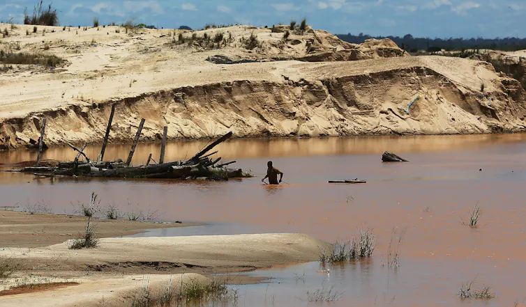
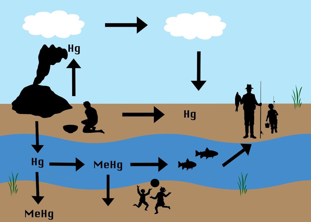
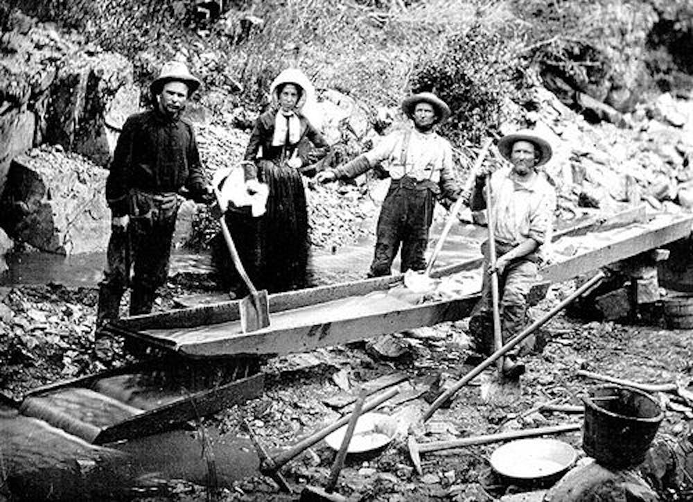

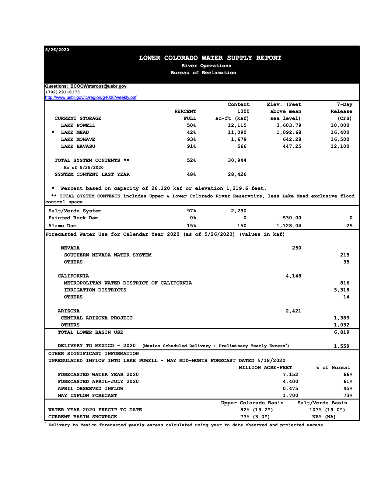
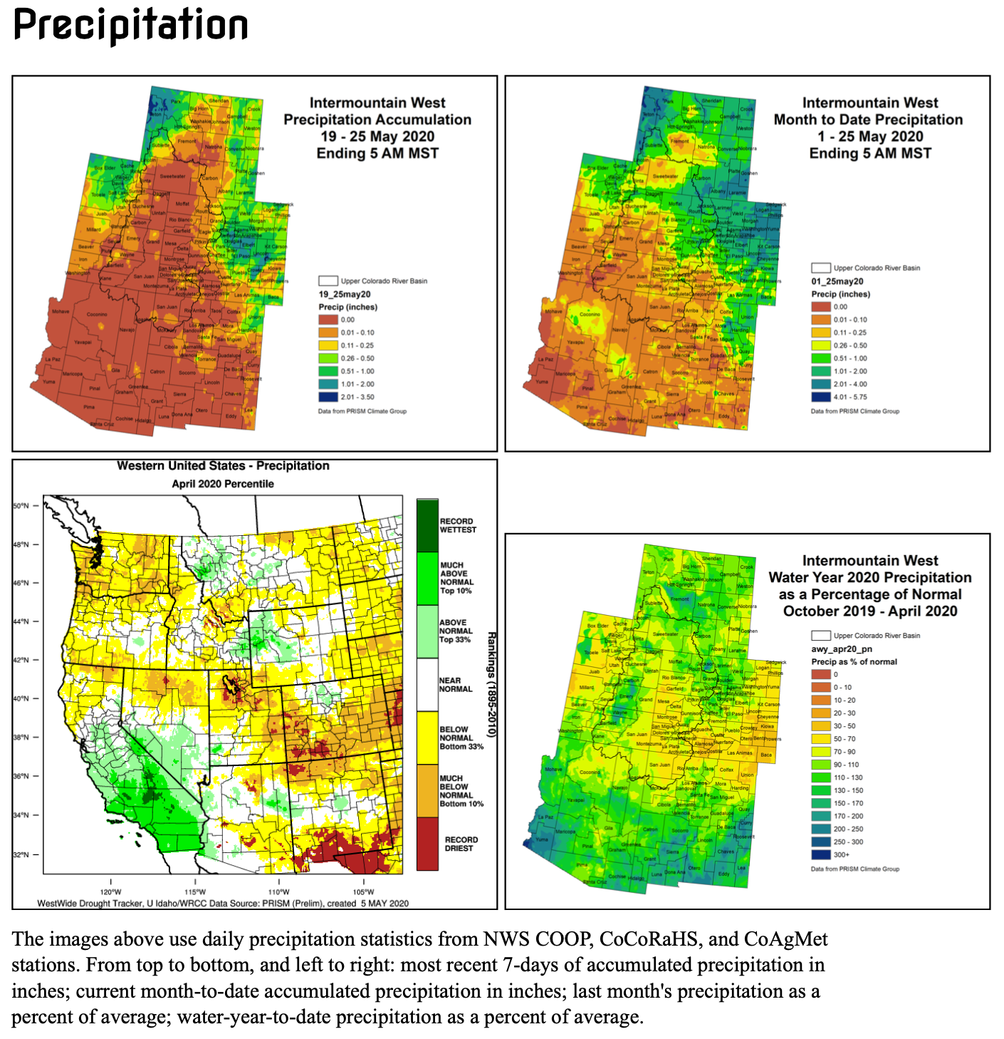
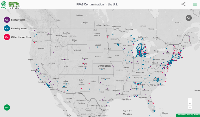


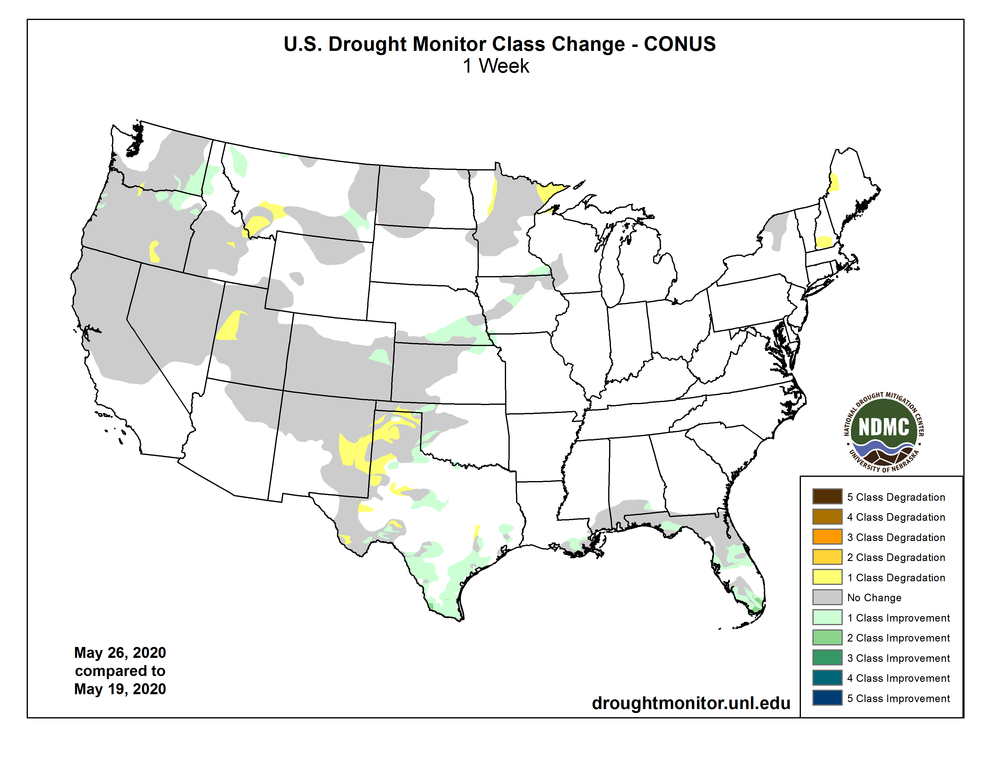


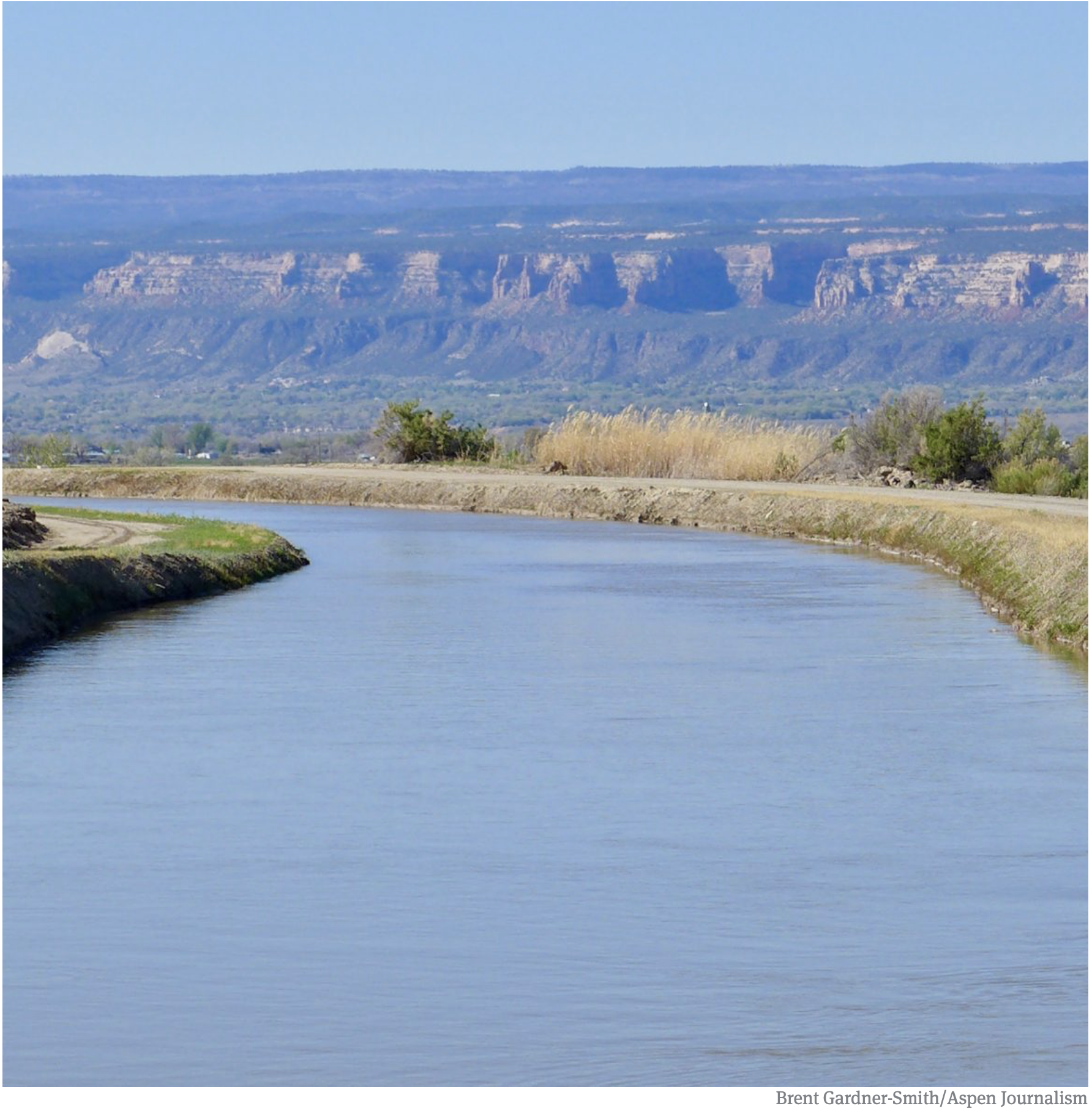

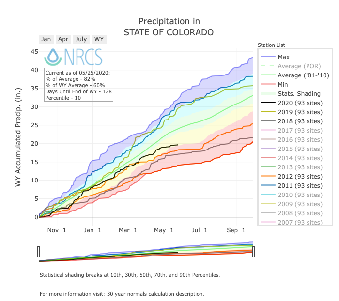
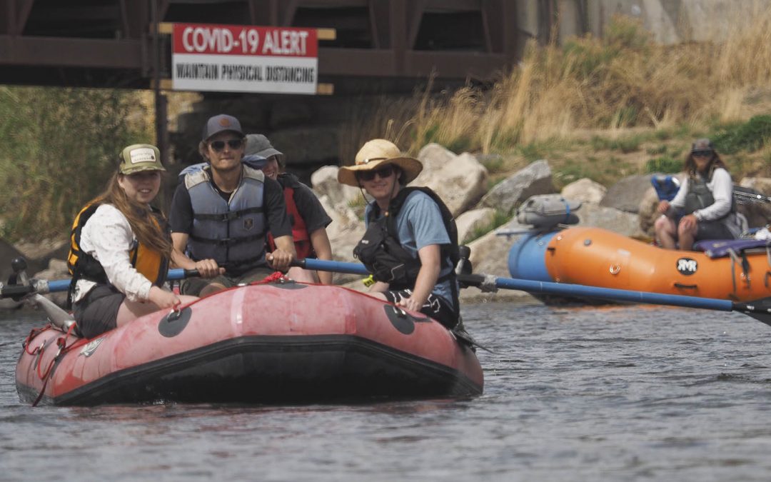
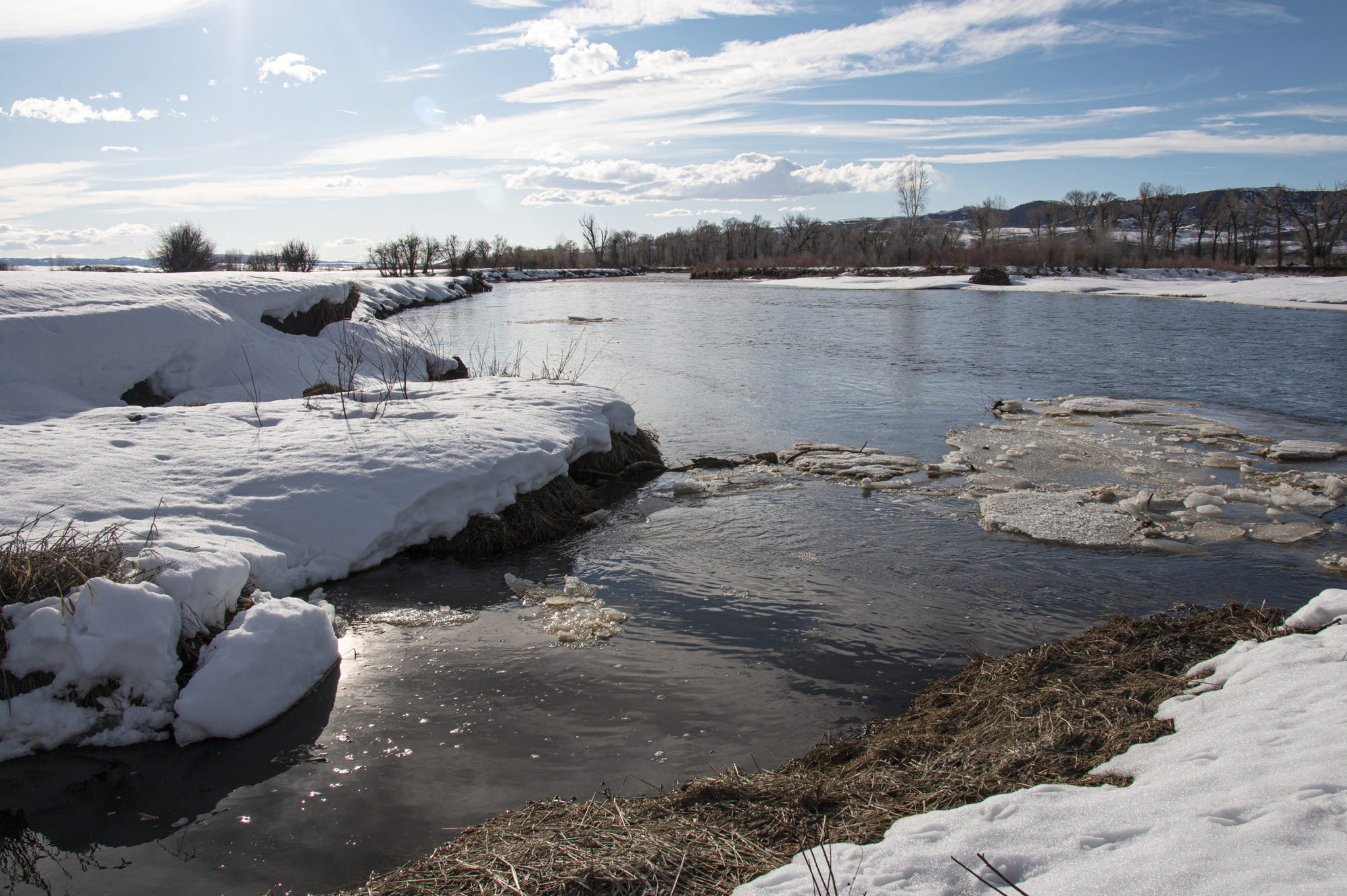


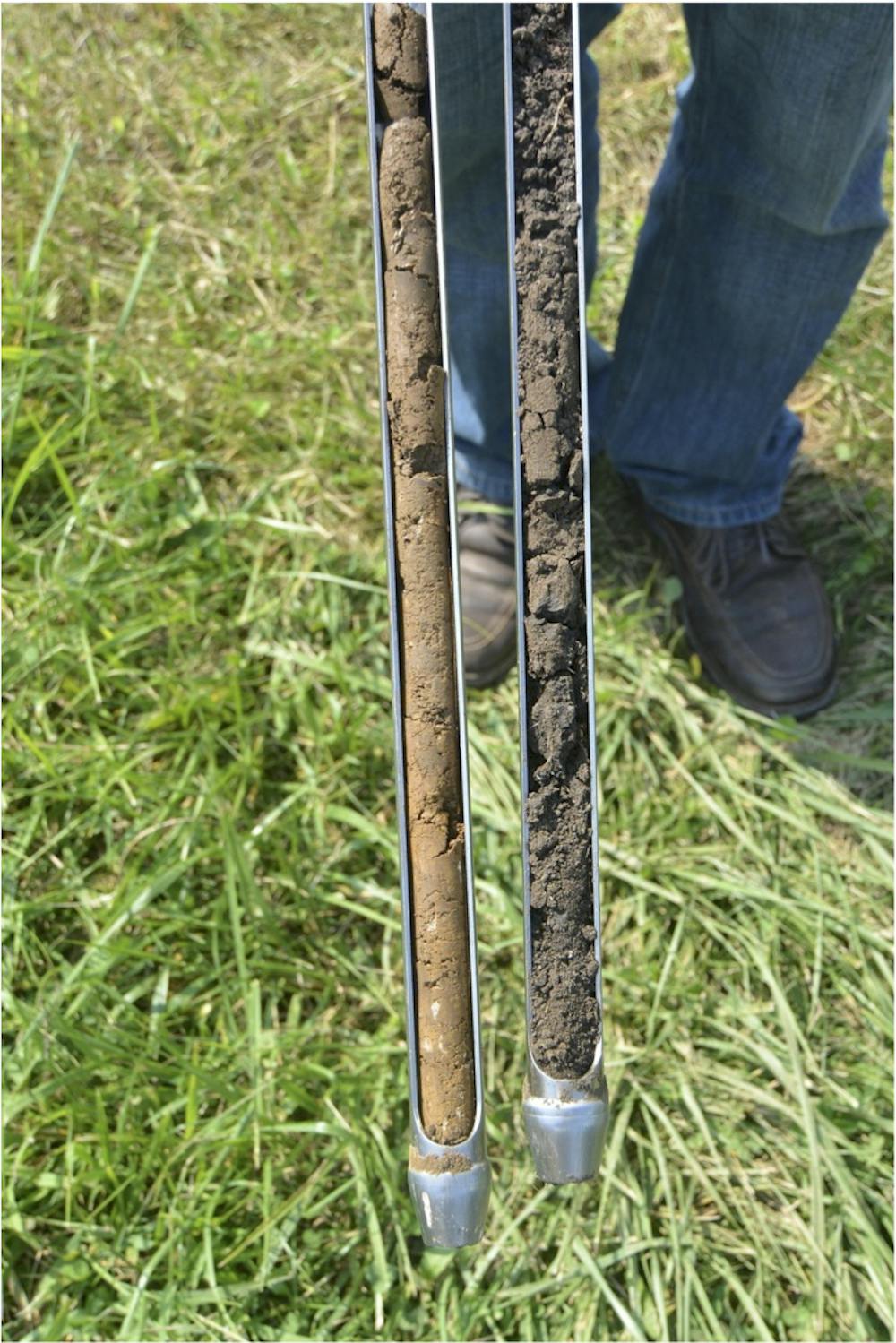


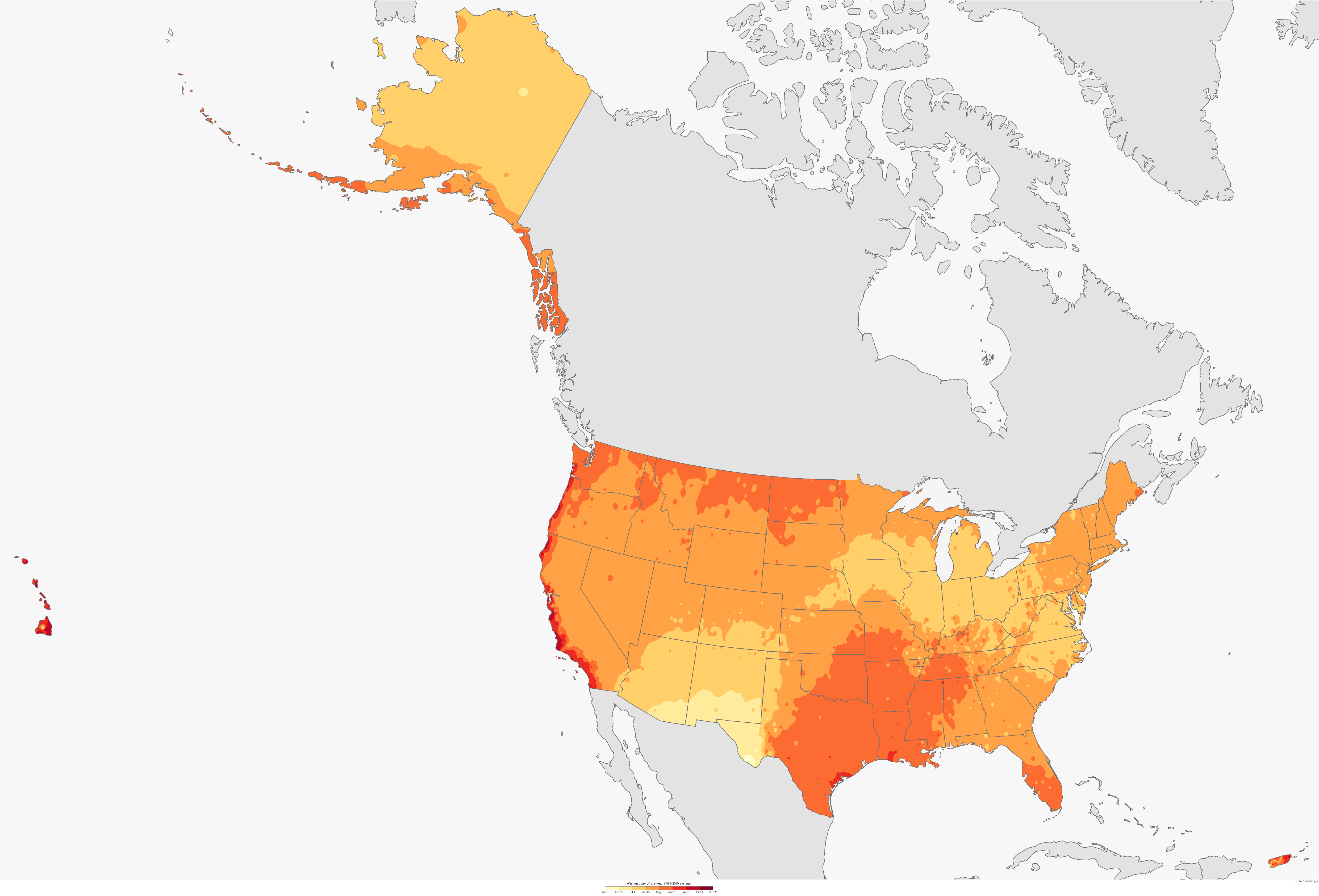

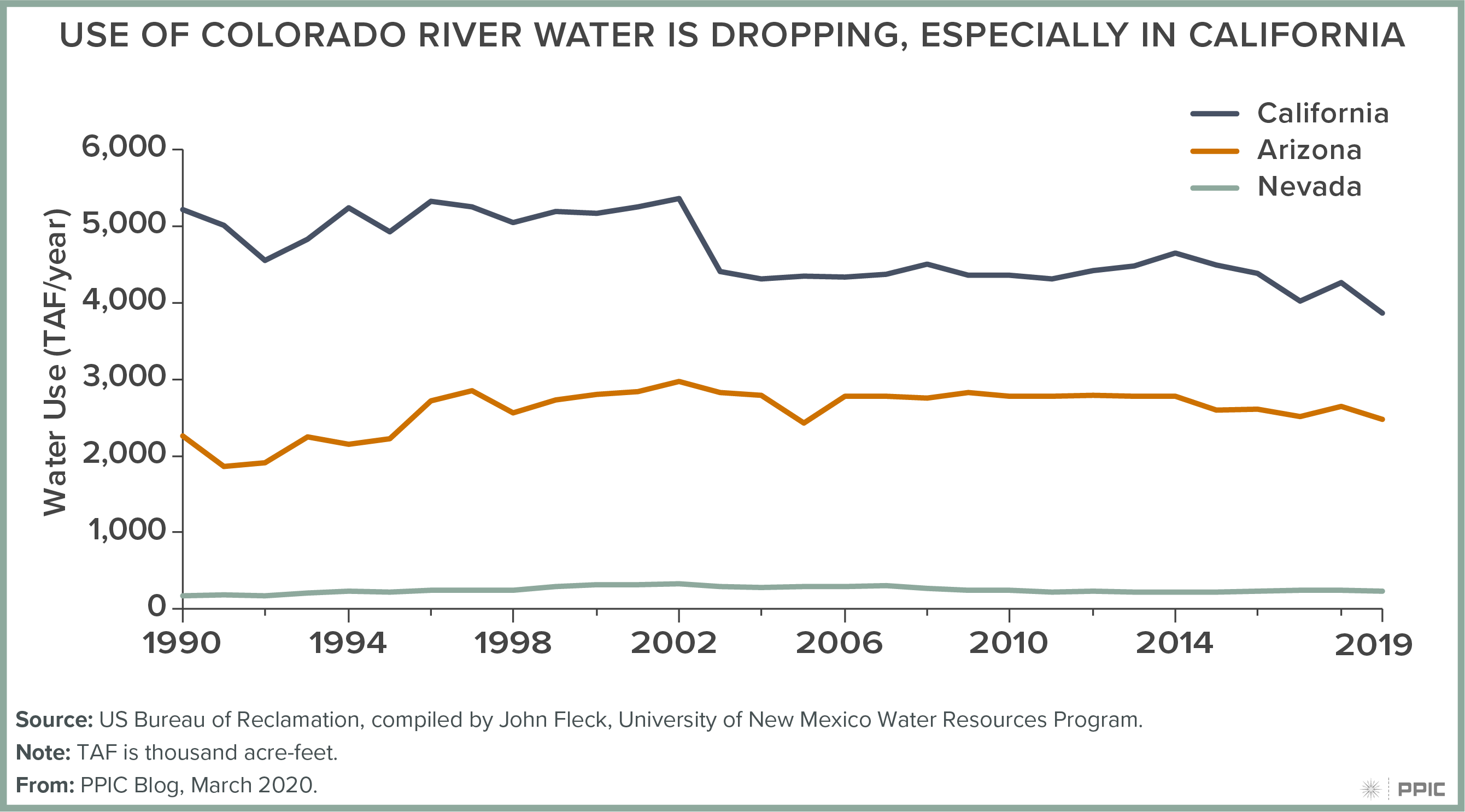

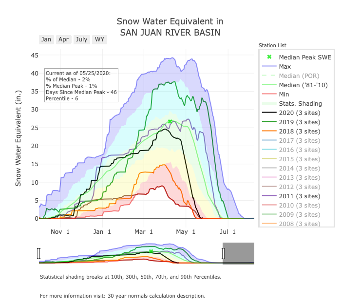
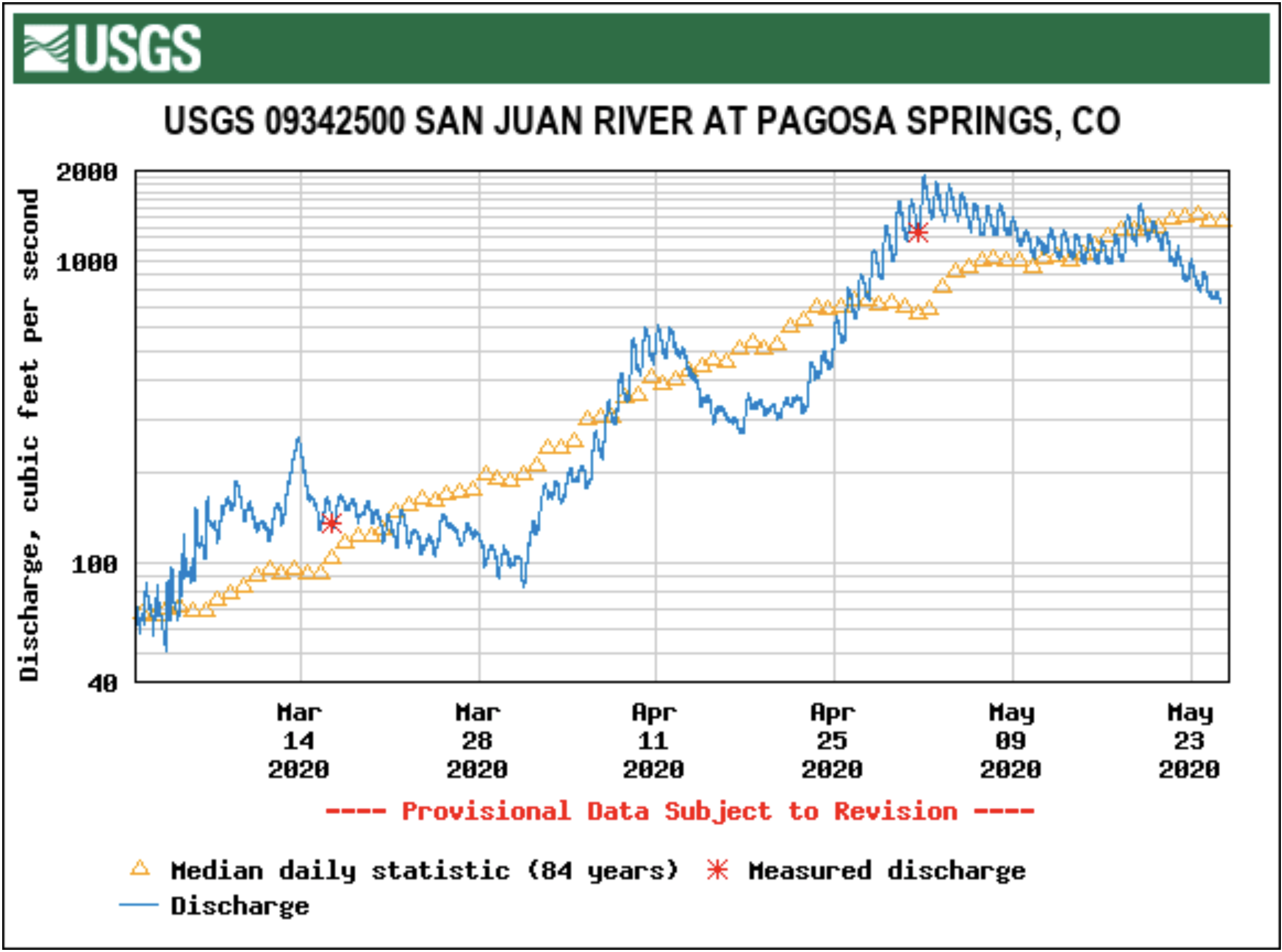


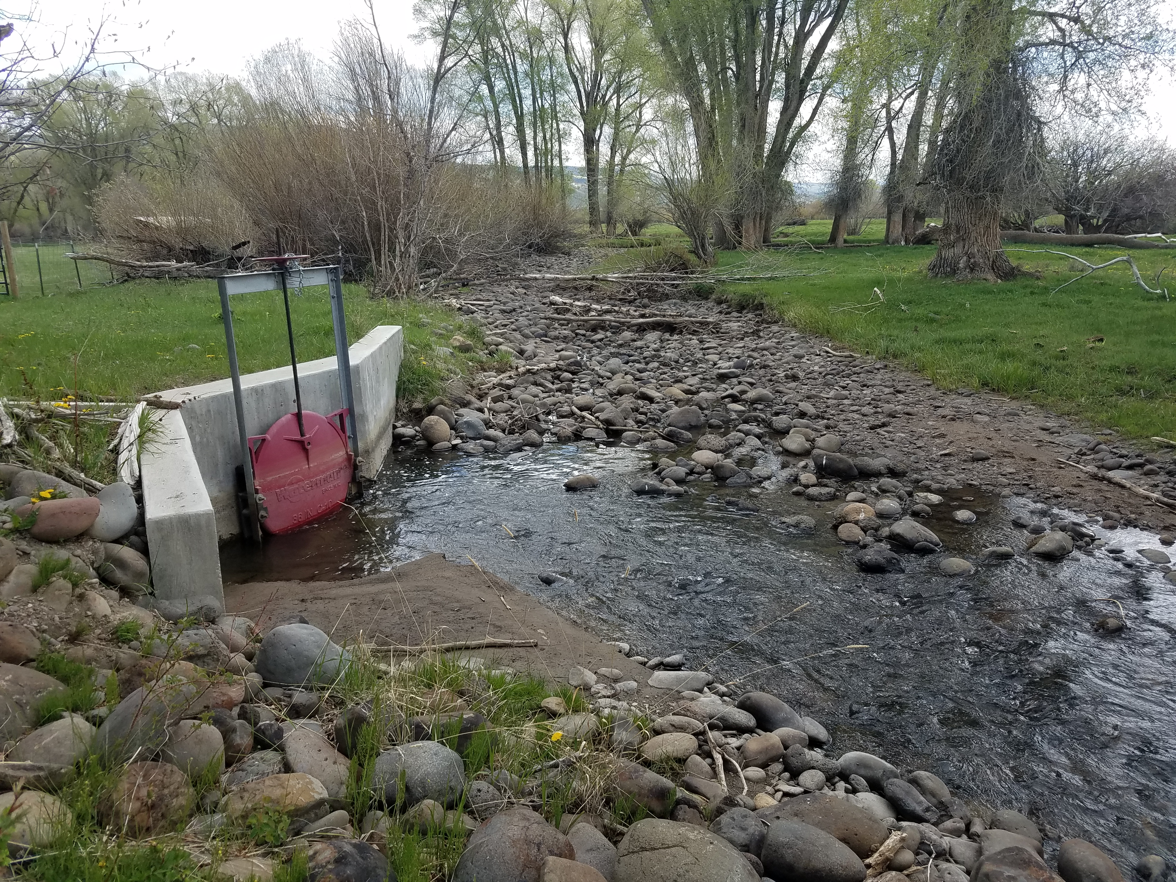
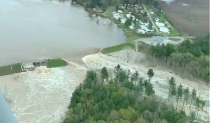


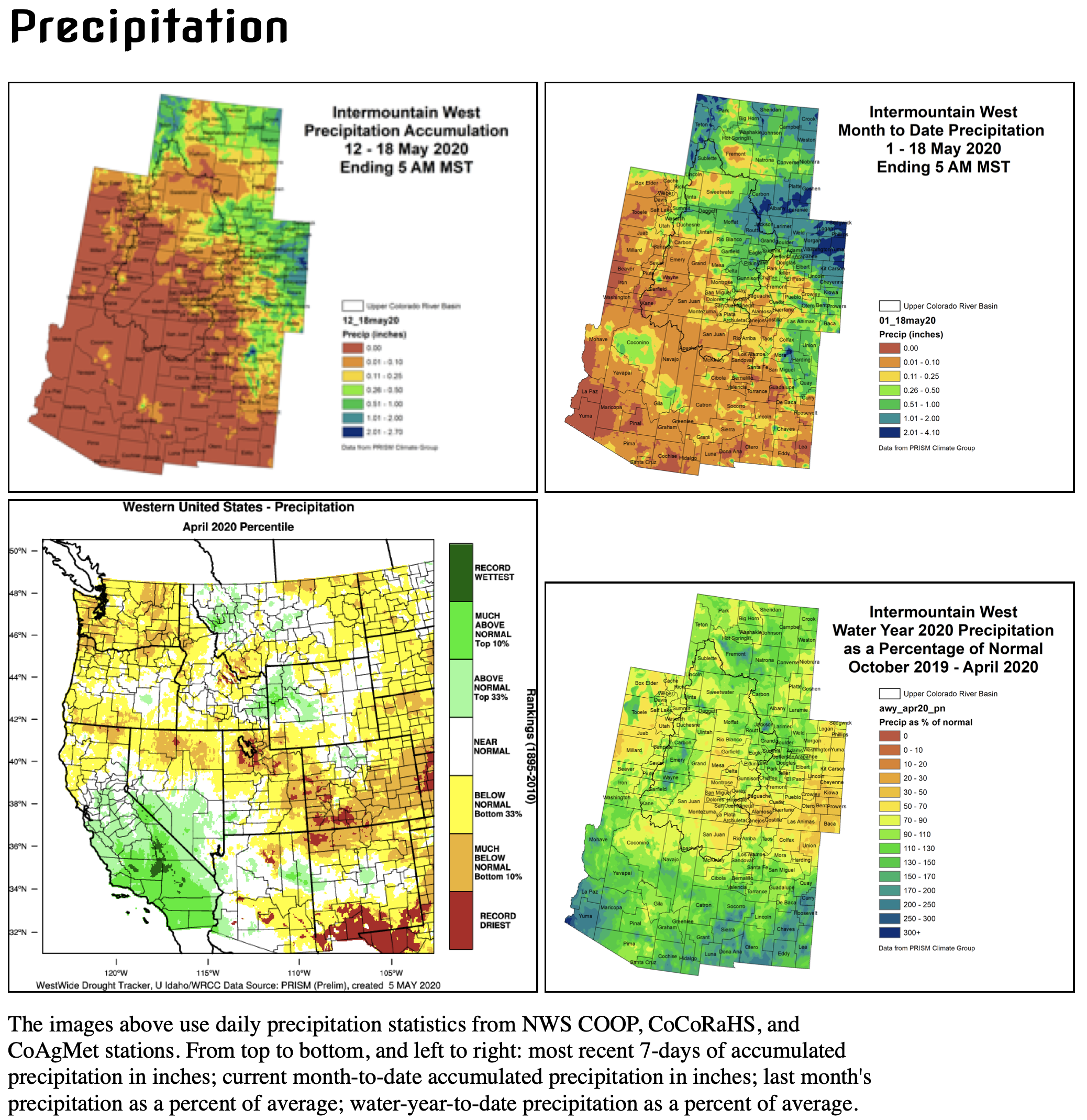

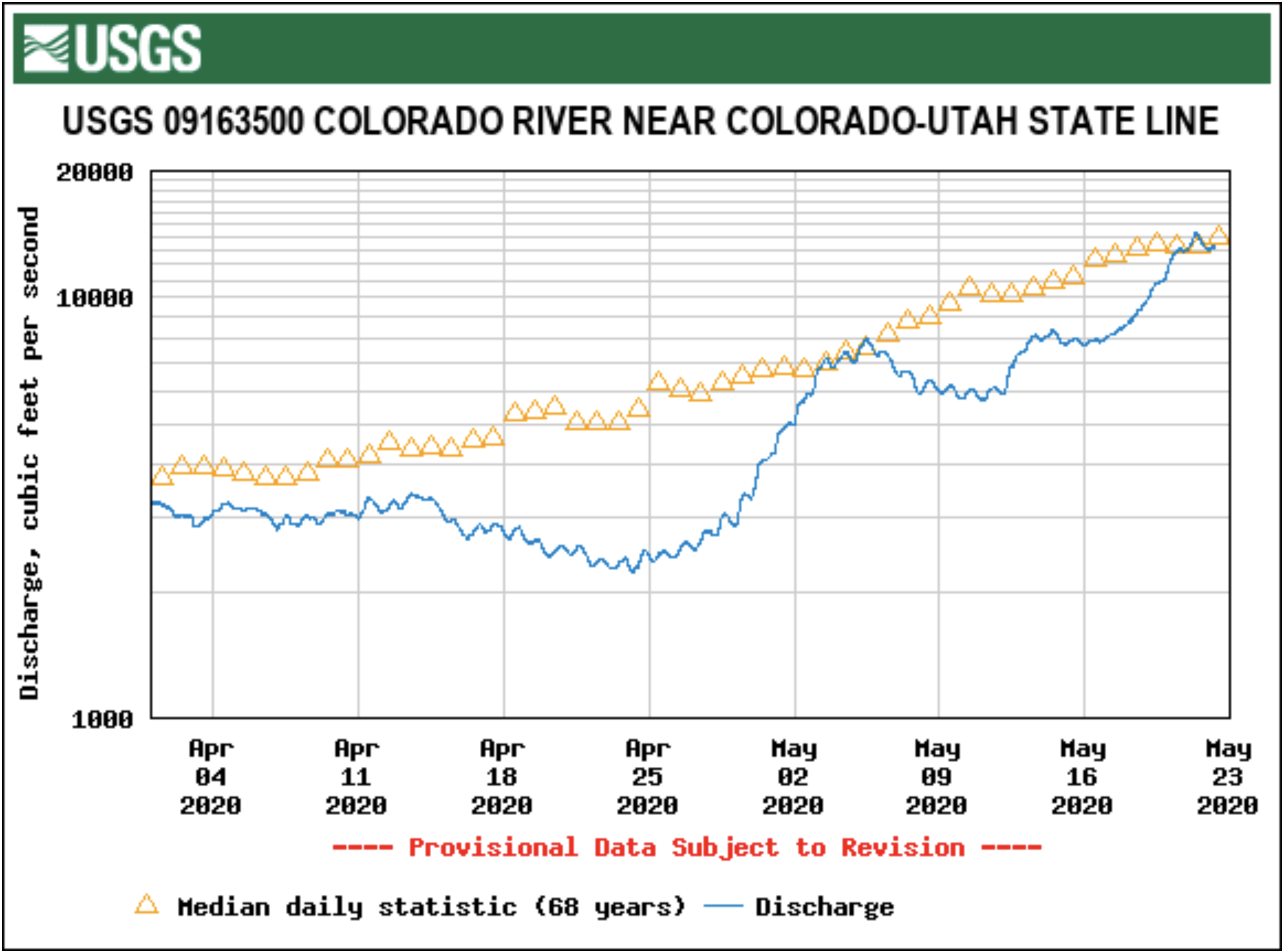