Click on a thumbnail graphic to view a gallery of drought data from the US Drought Monitor.


Click here to go to the US Drought Monitor website. Here’s an excerpt:
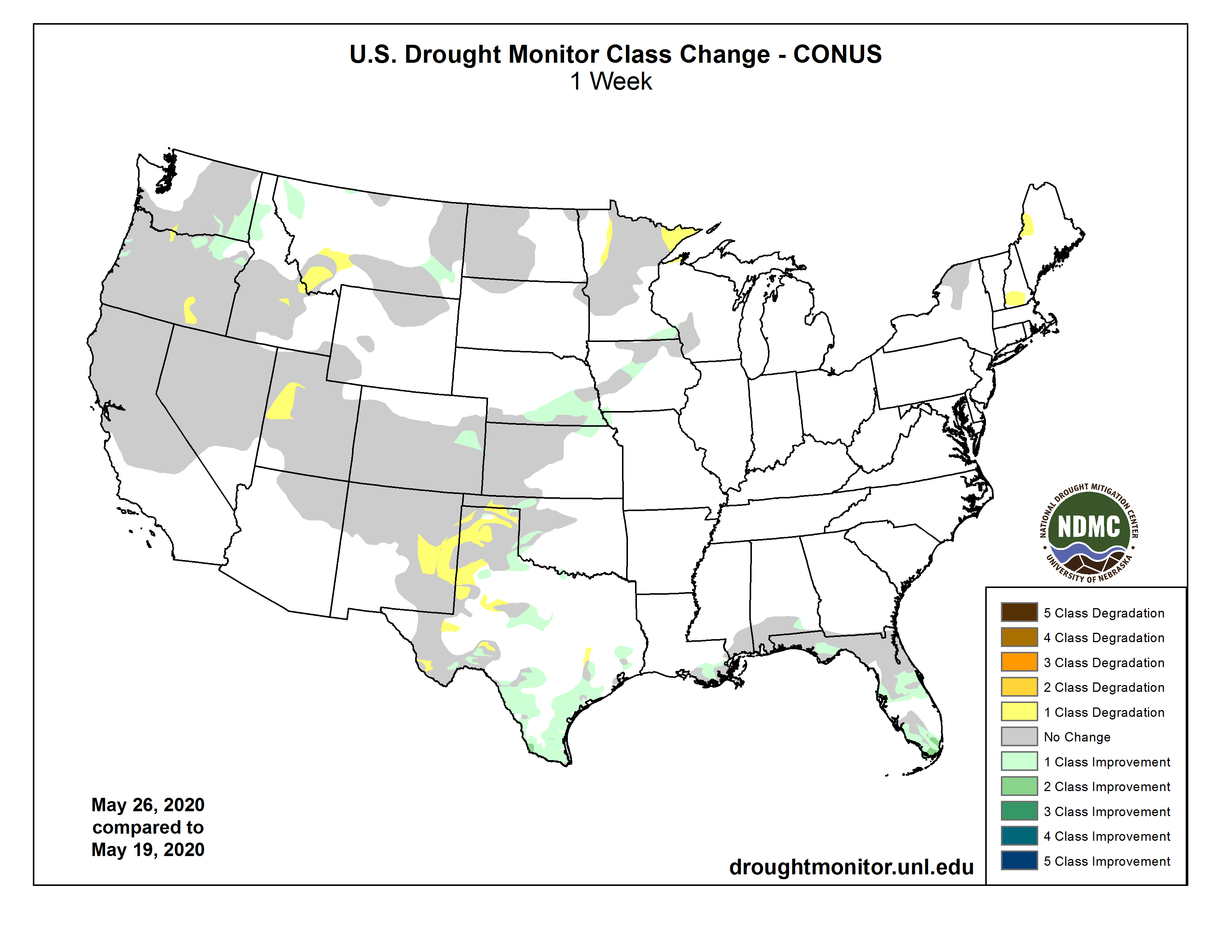
This Week’s Drought Summary
During the past week, widespread rain and thunderstorms fell across parts of the Great Plains, including a few instances of severe weather. Particularly large amounts of rain in central and eastern Nebraska, as well as in adjacent states, improved what had been a quickly drying scenario in many locations. Above-normal precipitation also fell in parts of the Northwest, which led to improvement in parts (though not all) of the ongoing drought areas there. Large rainfall amounts also occurred in south Florida and in parts of the central Florida Panhandle, leading to improvements in or removal of drought in these locations. Widespread rain in parts of Texas also led to drought improvement in the state, though some areas that missed out on the rain (particularly in the Panhandle) saw conditions worsen. Moderate and severe drought were also added to parts of Molokai and the Big Island in Hawaii. Moderate drought coverage lessened in southern Louisiana after precipitation fell there…
As several slow-moving low pressure systems crossed the region this week and weekend, areas of rain and thunderstorms were common, excluding northeast South Dakota, eastern North Dakota, and parts of the southeast Colorado high plains. Temperatures were quite variable across the region, but were generally lowest (2 to 4 degrees cooler than normal) in central Kansas and south-central Nebraska, and warmest in South Dakota and North Dakota, the latter of which had widespread temperatures from 6 to 8 degrees warmer than normal. Rain from a cluster of thunderstorms on Thursday in southwest Kansas prevented conditions from worsening there, though southwest Kansas and adjacent eastern Colorado remain very dry, and moderate, severe, and extreme drought persisted across parts of these areas. Extreme drought lessened in coverage in part of eastern Colorado due to recent rainfall and lessened short-term precipitation deficits. In northern Kansas and Nebraska, heavy rain from a series of slow-moving storm systems improved what had been abnormally dry conditions in some areas. Short-term moderate drought persisted this week in southwest North Dakota and far northwest South Dakota…
Precipitation fell this week across much of Montana (excluding southwest Montana), Idaho, eastern Oregon, parts of Washington, central and northeast Nevada, northern Utah, northwest Wyoming, central Colorado, and parts of eastern Wyoming. New Mexico was mostly dry this week, aside from a bit of rain across the far northeastern high plains. Warmer than normal temperatures could be found in coastal California, but otherwise, below-normal temperatures were common across the Intermountain West. In western Utah, severe drought expanded westward as a result of worsened short- and long-term precipitation deficits. Severe drought expanded northward in central Idaho, where streamflow had become very low in the Big Lost River area. Farther northwest in Idaho, and in adjacent parts of northeast Oregon and southeast Washington, recent precipitation resulted in lessened precipitation deficits and improved streamflow, leading to improvements in drought conditions and abnormal dryness in these areas. Recent precipitation also led to the removal of moderate drought in northwest Montana. Areas of southwest Montana and adjacent northeast Idaho that missed out on the larger precipitation amounts this week slipped into moderate drought as a result of growing short- and long-term precipitation deficits. Severe drought was added to the map in southeast Oregon, where short- and long-term precipitation deficits continued to grow. Growing precipitation deficits over the water year and lessening streamflow led to the extension of moderate drought in a small part of north-central Oregon and adjacent south-central Washington. Recent precipitation led to a slight reduction in coverage of moderate and severe drought in western Oregon. Moderate drought coverage increased in eastern New Mexico due to increasing short-term precipitation deficits and high evaporative demand…
Widespread precipitation fell this week across parts of central and north Texas, including parts of the Texas Panhandle. Widespread rain also fell in Oklahoma, though this missed the western part of the Oklahoma Panhandle. Rain also fell over much of Arkansas (excluding far southeast), much of Louisiana (though generally excluding the immediate Gulf Coast), and southeast Mississippi. Heavier rain (2-3 inches) also occurred in eastern Tennessee this week, although eastern Kentucky received greater amounts. Moderate drought conditions improved in parts of south-central Louisiana, where soil moisture and short-term precipitation deficits had lessened. Drought conditions improved in parts of Texas where rainfall this week lessened short-term deficits, while many areas that missed the higher rainfall amounts worsened, particularly in the drier parts of the Texas Panhandle. In Oklahoma, parts of western Oklahoma and the Panhandle that received more rainfall had improvements. However, rainfall missed the western Oklahoma Panhandle, where severe drought continues, and precipitation deficits on both short- and long-term scales have continued to worsen here…
Looking Ahead
During the first week of June, the National Weather Service Climate Prediction Center is forecasting a high probability of warmer than normal temperatures across most of the continental United States (excluding the East Coast, south Texas, and the Pacific Northwest). The highest probability for above-normal temperatures is centered on the Central Great Plains. The Intermountain West, in particular the Four Corners, northwest Nevada, and southeast Oregon, are favored to have above-normal precipitation, while areas close to the Canadian border (to the west of Lake Huron) are also slightly favored for above-normal precipitation. Meanwhile, most areas from the central and southern Great Plains to the Atlantic Seaboard are favored to have below-normal precipitation, with the exceptions of south Florida and south Texas.