Click on a thumbnail graphic to view a gallery of drought data from the US Drought Monitor.
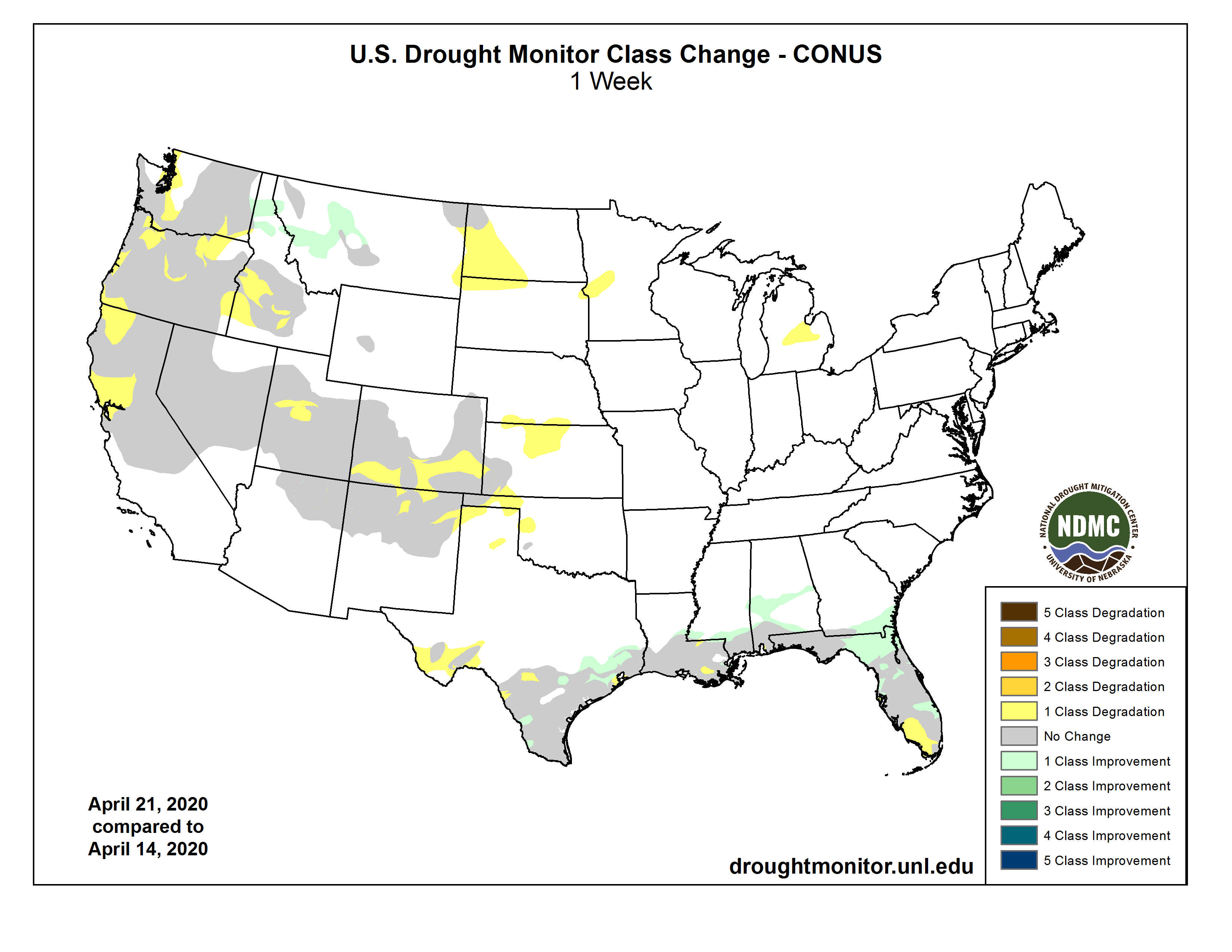
US Drought Monitor April 28, 2020.
West Drought Monitor April 28, 2020.
Colorado Drought Monitor April 28, 2020.
Click here to go to the US Drought Monitor website. Here’s an excerpt:
This Week’s Drought Summary
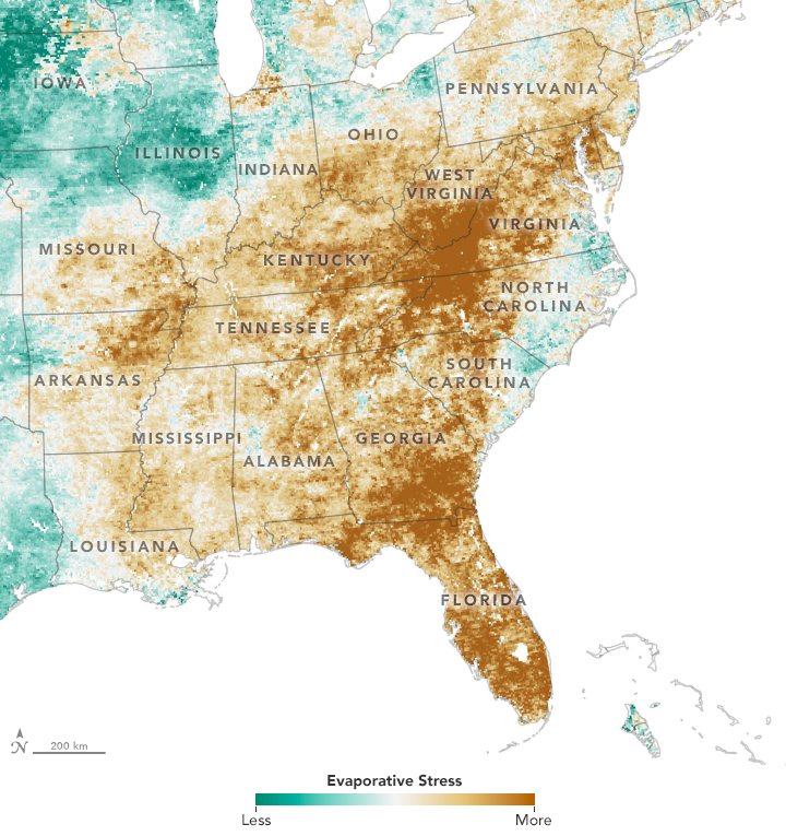
An active pattern of storms brought cold, wet weather to the Northeast, rain and locally severe thunderstorms to parts of the South, lower Midwest, and Southeast. Drought areas along the western Gulf Coast missed the heaviest rains, while those in the eastern half fared better. A ridge of high pressure over the West kept conditions warm and dry…
Temperatures across the High Plains were generally warmer than normal last week with departures of 2 to 6 inches above normal. Much of the region received less than 0.5 inches of precipitation. Exceptions included parts of eastern North Dakota, South Dakota, and Nebraska, with totals of more than 1 inch, and eastern Kansas, with amounts of more than 2 inches – nearly 200% of normal. The warm, dry conditions led to an expansion of abnormal dryness (D0) in the Dakotas, southwest Nebraska, northwest Kansas, and eastern Colorado. Additionally, moderate and severe drought (D1 and D2) expanded over Colorado’s eastern plains. This area has failed to receive the timely spring rains needed, resulting in reductions in soil moisture, streamflow, and vegetation health. Across the entire High Plains region, local drought experts are discussing the emerging dryness and closely monitoring the situation as planting begins and the need for moisture increases…
Most of the western U.S. received little to no rain, except for small pockets of the Pacific Northwest and the Southwest. Temperatures were generally above normal, with record-setting heat across parts of the Southwest and daily highs of 10 to 20 degrees above normal. The heat and dry weather led to deteriorating conditions across several states. In Oregon, severe drought (D2) expanded near Portland and in the north-central part of the state in response to drying soils, vegetation stress, and streamflow and groundwater declines. Precipitation for the water year ranks as the third driest in the Portland station’s 89-year period of record. In northern California, moderate drought (D1) expanded. While the state coordination committee noted that reservoir levels are acceptable, precipitation deficits are less 50% of normal for the water year, streamflow values are low, and rangeland grasses have been affected by the lack of moisture and heat. Likewise, parts of central Nevada also saw expansions to D1 and the introduction of D2 in response to increasing moisture deficits, declining streamflow and groundwater levels, and vegetation stress. The only improvements on this week’s map included minor reductions in D1 in Oregon and D0 in Washington in response to locally heavy rainfall…
Locally heavy rain and thunderstorms fell across the eastern half of the southern region. The largest totals (4 inches or more) were recorded in Louisiana and Mississippi. Temperatures were near to below normal, with the largest departures (5 degrees below normal) recorded in Tennessee. For the most part, the rain either missed the drought areas near the coast or wasn’t enough to warrant improvements in conditions, instead preventing degradations. The western half of the region generally saw little or no rain again this week. Weekly average temperatures ranged from 2 to 8 degrees above normal, with locations in south Texas setting daily record highs with temperatures reaching triple digits. The warm, dry weather continued to deplete moisture supplies, stress vegetation, and deteriorate drought conditions across parts of the Texas Gulf Coast, with expansions to moderate (D1), severe (D2) and extreme (D3) drought. Texas also saw improvements as localized rain improved soil moisture, vegetation health, and streamflow…
Looking Ahead
The National Weather Service Weather Prediction Center forecast for the remainder of the week calls for continued wet conditions across much of the eastern U.S., with the highest values (more than 2 inches) expected over the Mid-Atlantic. Temperatures in the eastern half of the country are expected to be near to above normal, with departures of 1 to 8 degrees, over the weekend. For the western half of the country, areas expected to receive an inch or more of precipitation include parts of the Pacific Northwest, northern Rockies, and Central Plains. In the Southwest, dry weather with temperatures 10 to 15 degrees above normal is expected to continue. Moving into next week, the Climate Prediction Center 6-10 day outlook (valid May 5-9) favors below-normal temperatures for the much of eastern half of the country. Above-normal temperatures are expected throughout the West, the southern Plains, along the Gulf Coast, and throughout Florida. The greatest probabilities for above-normal precipitation are expected from northern Texas to the Middle Mississippi Valley and along the Mid-Atlantic and New England coasts.
US Drought Monitor one week change map ending April 28, 2020.
Two separate coalitions of environmental advocacy groups filed litigation on Wednesday against the U.S. Environmental Protection Agency and the Army Corps of Engineers challenging the Trump Administration’s rollback of the Clean Water Act.
At the core of the litigation is the definition of federally protected waterways, as recent changes in regulatory language have reduced legal protections for huge numbers of streams, especially around the arid West…
“This regulation is plainly unlawful. It violates the simple but powerful mandate of the Clean Water Act to protect the integrity of our nation’s waters,” Jon Devine, the Natural Resources Defense Council’s director of federal water policy, said in a statement announcing one of the legal petitions.
The NRDC — joined by seven other environmental groups from Wisconsin, New Mexico and elsewhere — filed a challenge in a federal district court in Massachusetts.
The other lawsuit was launched by more than a dozen national and local environmental organizations in the federal district court in South Carolina. It claims that the EPA and the Army Corps “neglected fundamental rulemaking requirements meant to constrain whimsical agency action.”
The Environmental Protection Agency and the Department of the Army published April 21 in the Federal Register the final replacement rule defining what waters are federally regulated under the Clean Water Act. The rule, which is set to take effect June 22, had been met with both support and promises of legal action.
The EPA and Department of the Army have 60 days to respond to the lawsuit.
The groups that joined in the legal challenge include the North Carolina Coastal Federation, which publishes Coastal Review Online, along with American Rivers, Charleston Waterkeeper, Chattahoochee Riverkeeper, Clean Water Action, Defenders of Wildlife, Environment America, Friends of the Rappahannock, James River Association, National Wildlife Federation, North Carolina Wildlife Federation, Public Employees for Environmental Responsibility, Roanoke River Basin Association and South Carolina Coastal Conservation League.
“We are particularly concerned that many wetlands along our coast will no longer be regulated by the federal government,” said Todd Miller, executive director of the Coastal Federation.
“These areas include pocosins, Carolina Bays and other forested wetlands. These wetlands protect water quality in our coastal estuaries and reduce floods during storms. Current wetland rules, that have been in place for decades, balance the needs of landowners with these environmental and economic benefits,” he continued. “Losing this oversight by adoption of these new rules will result in more water pollution, less fish, and more costly disasters in coming years.”
[…]
The administration’s Navigable Waters Protection Rule is the second step in revising the definition of the scope of waters subject to federal regulation under the Clean Water Act and repeals the 2015 Clean Water Rule: Definition of “Waters of the United States,” often called “WOTUS.” The final rule “recognizes that waters of the United States are those within the ordinary meaning of the term, such as oceans, rivers, streams, lakes, ponds, and wetlands, and that not all waters are waters of the United States,” according to the April 21 document.
The final rule specifically states that waters of the United States do not include groundwater; ephemeral, or impermanent, streams, swales, gullies, rills and pools made by rain; diffuse stormwater runoff, which is rainwater that spreads across the landscape, and features that control stormwater; previously converted croplands; ditches that are not traditional navigable waters, tributaries, or that are not constructed in adjacent wetlands; and other exclusions.
Gov. Jared Polis, even as COVID-19 swept across the state, gave his stamp of approval to five major pieces of water legislation, paving the way for everything from more water for environmental streamflows to a new study on how to limit water speculation.
Lawmakers announced March 13 that they would temporarily suspend work to comply with stay-at-home orders, and now plan to return May 18 to complete the session.
Signed into law in late March and early April, the new measures represent months if not years of negotiations between farm, environmental and legal interests that came to fruition this year thanks to hard-fought bipartisan agreements.
Three of the new laws address water for streams, fish and habitat, allowing more loans of water to bolster environmental flows, protecting such things as water for livestock from being appropriated for instream flows, and using an existing water management tool, known as an augmentation plan, to set aside water rights for streams.
Expanded instream flow loans
House Bill 1157 expands the state’s existing instream flow loan program, which allows a water right holder to loan water to the Colorado Water Conservation Board to preserve flows on streams where the state agency already holds an instream flow water right. The CWCB is the only entity in Colorado that can legally hold such rights, intended to benefit the environment by protecting a stream’s flows from being diverted below a certain level. Under existing law, a loan may be exercised for just three years in a single 10-year period.
The new law, however, expands the loan program by authorizing a loan to be used to improve as well as preserve flows, and increases the number of years it can be exercised from three to five, but for no more than three consecutive years. It also allows a loan to be renewed for two additional 10-year periods.
“This bill becoming law is crucial for our state’s rivers, our outdoor recreation businesses, and downstream agricultural users who depend on strong river flows,” said Rep. Dylan Roberts, D-Avon. After a similar bill he sponsored failed to pass last year, he said, “I knew I needed to work to bring more people to the table and improve the bill so we could garner the support we needed, and that is what we did. I am thrilled that we were able to get this done with strong bipartisan support.”
To ensure protection of existing water rights, House Bill 1157 increases the comment period on loan applications from 15 to 60 days; allows appeal of the State Engineer’s decision on a loan application to water court; and requires the CWCB to give preference to loans of stored water over loans of direct flow water where available.
“There’s no injury to other water uses. And there’s a methodology if someone feels they are injured they can go to the water referee in an expedited manner,” said Rep. Perry Will, R-New Castle and one of the bill’s sponsors.
Protecting existing water uses
House Bill 1159 provides a means for existing water uses, such as water for livestock, that have not been legally quantified to continue when an instream flow right downstream is designated. Current law is unclear as to whether preexisting uses that lack a court decree are protected. To provide clarity, the bill requires the State Engineer to confirm any claim of an existing use in administering the state’s instream flow program.
Augmentation of instream flows
House Bill 1037 authorizes the CWCB to use an acquired water right, whose historic consumptive use has been previously quantified and changed to include augmentation use, to increase river flows for environmental benefits. Farmers have long used so-called augmentation water to help offset their water use, particularly of groundwater, when that use is not in priority within Colorado’s water rights system. Now that same water can be used to boost environmental flows.
Anti-speculation study and water conservation in master planning
Beyond instream flows, Gov. Polis signed Senate Bill 48, which requires the Colorado Department of Natural Resources to form a working group to explore ways to strengthen anti-speculation laws. The agency must report its recommendations to the interim Water Resources Review Committee by Aug. 15, 2021.
Also signed into law was House Bill 1095, which authorizes counties and municipalities that have adopted master plans that contain a water supply element to include state water plan goals and conservation policies that may affect land development approvals.
Larry Morandi was formerly director of State Policy Research with the National Conference of State Legislatures in Denver, and is a frequent contributor to Fresh Water News. He can be reached at larrymorandi@comcast.net.
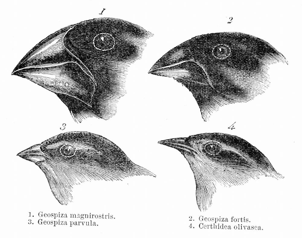
Charles Darwin popularized the concept of survival of the fittest as a mechanism underlying the natural selection that drives the evolution of life. Organisms with genes better suited to the environment are selected for survival and pass them to the next generation.
Thus, when a new infection that the world has never seen before erupts, the process of natural selection starts all over again.
In the context of the coronavirus pandemic, who is the “fittest”?
This is a challenging question. But as immunologyresearchers at the University of South Carolina, we can say one thing is clear: With no effective treatment options, survival against the coronavirus infection depends completely on the patient’s immune response.
We have been working on how the immune response is a double-edged sword – on one hand helping the host to fight infections, while on the other hand causing significant damage in the form of autoimmune diseases.
Darwin recognized that finches with beaks adapted to the specific food sources present on an island were more likely to survive and pass their genes to the next generation. Birds with the right beaks were defined as the fittest. Photos.com
The two phases of the immune response
The immune response is like a car. To reach a destination safely, you need both an accelerator (phase 1) and a brake (phase 2) that are functioning well. Failure in either can have significant consequences.
An effective immune response against an infectious agent rests in the delicate balance of two phases of action. When an infectious agent attacks, the body begins phase 1, which promotes inflammation – a state in which a variety of immune cells gather at the site of infection to destroy the pathogen.
This is followed by phase 2, during which immune cells called regulatory T cells suppress inflammation so that the infected tissues can completely heal. A deficiency in the first phase can allow uncontrolled growth of the infectious agent, such as a virus or bacteria. A defect in the second phase can trigger massive inflammation, tissue damage and death.
The coronavirus infects cells by attaching to a receptor called the angiotensin-converting enzyme 2 (ACE2), which is present in many tissues throughout the body, including the respiratory tract and cardiovascular system. This infection triggers a phase 1 immune response, in which the antibody-producing B-cells pump out neutralizing antibodies that can bind to the virus and prevent it from attaching to ACE2. This inhibits the virus from infecting more cells.
During phase 1, the immune cells also produce cytokines, a group of proteins that recruit other immune cells as well as fight infection. Also joining the fight are killer T cells that destroy the virus-infected cells, preventing the virus from replicating.
If the immune system is compromised and works poorly during phase 1, the virus can replicate rapidly. People with compromised immune systems include the elderly, organ transplant recipients, patients with autoimmune diseases, cancer patients undergoing chemotherapy and individuals who are born with immunodeficiency diseases. Many of these individuals may not produce enough antibodies or killer T cells to counter the virus, which allows the virus to multiply unchecked and cause a severe infection.
Molecular model of a coronavirus spike (S) protein (red) bound to an angiotensin-converting enzyme 2 (ACE2) receptor (blue) on a human cell. Once inside the cell, the virus uses the cells’ machinery to make more copies of itself. JUAN GAERTNER/SCIENCE PHOTO LIBRARY
Lung injury resulting from inflammation
Increased replication of SARS-CoV-2 triggers additional complications in the lungs and other organs.
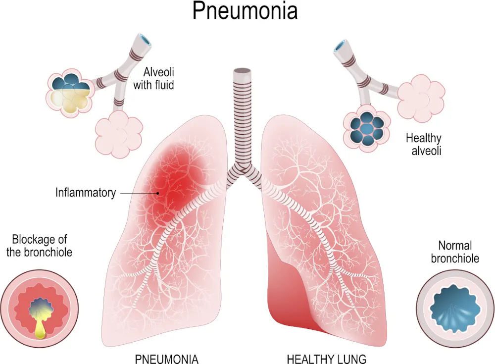
Normally, there is a wide range of microorganisms, both harmful and benign, that live in harmony in the lungs. However, as the coronavirus spreads, it is likely that the infection and the inflammation that ensues will disrupt this balance, allowing harmful bacteria present in the lungs to dominate. This leads to development of pneumonia, in which the lungs’ air sacs, called alveoli, get filled with fluid or pus, making it difficult to breathe.
When the alveoli, the location where oxygen is absorbed and carbon dioxide is expelled, is filled with liquid there is less space to absorb oxygen. ttsz / Getty Images
This triggers additional inflammation in the lungs, leading to Acute Respiratory Distress Syndrome (ARDS), which is seen in a third of COVID-19 patients. The immune system, unable to control viral infection and other emerging pathogens in the lungs, mounts an even stronger inflammatory response by releasing more cytokines, a condition known as “cytokine storm.”
At this stage, it is also likely that the phase 2 immune response aimed at suppressing inflammation fails and can’t control the cytokine storm. Such cytokine storms can trigger friendly fire – destructive, corrosive chemicals meant to destroy infected cells that are released by the body’s immune cells which can lead to severe damage to the lungs and other organs.
Also, because ACE2 is present throughout the body, the killer T cells from phase 1 can destroy virus-infected cells across multiple organs, causing more widespread destruction. Thus, patients that produce excessive cytokines and T cells can die from injury not only to the lungs but also to other organs such as the heart and kidneys.
The immune system’s balancing act
The above scenario raises several questions regarding prevention and treatment of COVID-19. Because the majority of people recover from coronavirus infection, it is likely that a vaccine that triggers neutralizing antibodies and T cells to block the virus from getting into the cells and replicate is likely to be successful. The key to an effective vaccine is that it doesn’t trigger excessive inflammation.
Additionally, in patients who transition to a more severe form such as ARDS and cytokine storm, which is often lethal, there is an urgent need for novel anti-inflammatory drugs. These drugs can broadly suppress the cytokine storm without causing excessive suppression of immune response, thereby enabling the patients to clear the coronavirus without damage to the lung and other tissues.
There may be only a narrow window of opportunity during which these immunosuppressive agents can be effectively used. Such agents should not be started at an early stage of infection when the patient needs the immune system to fight the infection, but it cannot be delayed too long after ARDS development, when the massive inflammation is uncontrollable. This window of anti-inflammatory treatment can be determined by monitoring the antibody and cytokine levels in patients.
With COVID-19, then, the “fittest” are individuals who mount a normal phase 1 and phase 2 immune response. This means a strong immune response in phase 1 to clear the primary coronavirus infection and inhibit its spread in the lungs. Then this should be followed by an optimum phase 2 response to prevent excessive inflammation in the form of “cytokine storm.”
Vaccines and anti-inflammatory treatments need to carefully manage this delicate balancing act to be successful.
With this coronavirus, it isn’t easy to know who are the fittest individuals. It isn’t necessarily the youngest, strongest or most athletic individuals who are guaranteed to survive this coronavirus. The fittest are those with the “right” immune response who can clear the infection rapidly without mounting excessive inflammation, which can be deadly.
From the Colorado Water Conservation Board (Ben Wade):
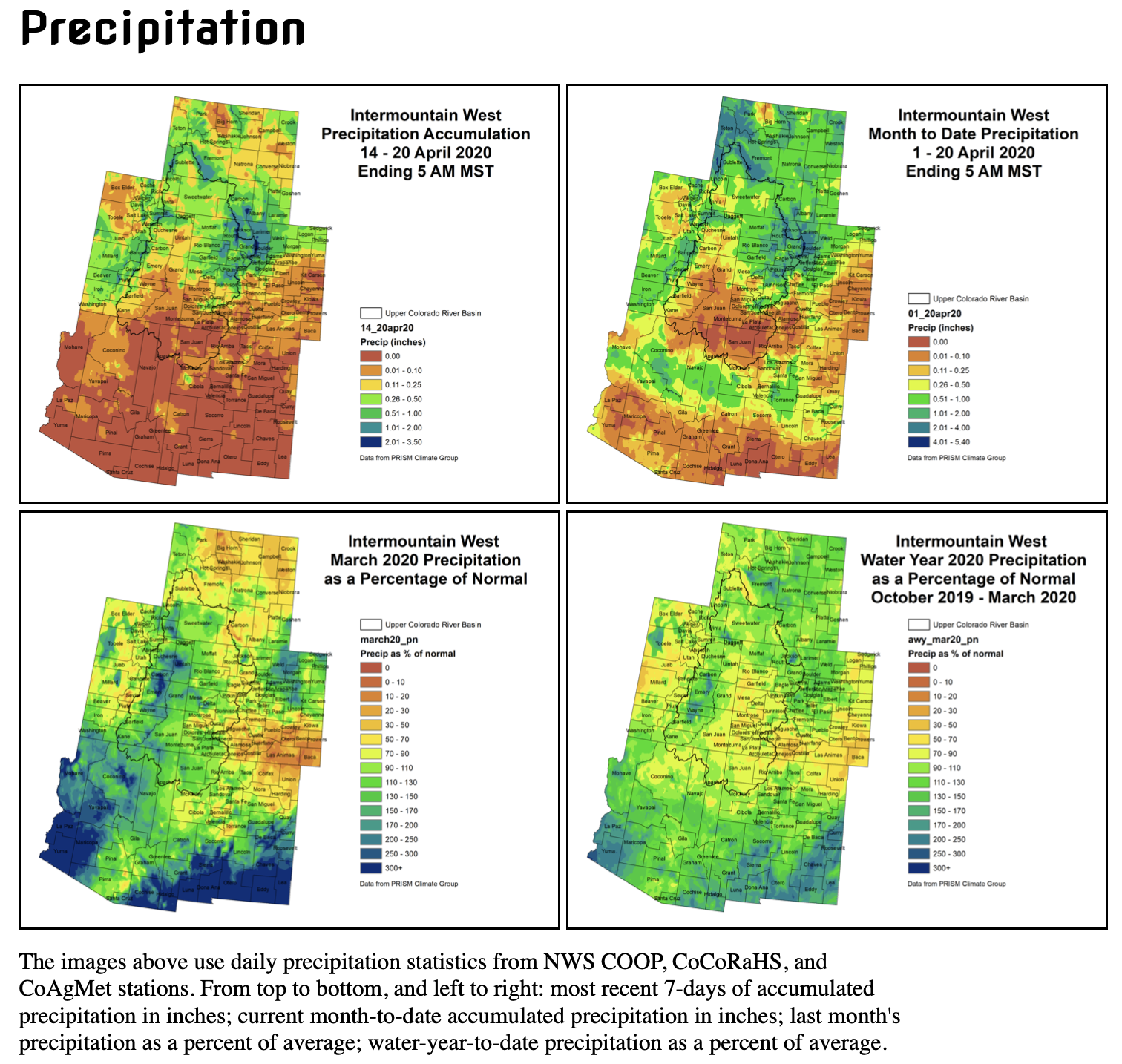
In western drought reporting, an average water year is cause for celebration. While average statewide snowpack and reservoir levels provide many water managers with above-average relief, our dry southern peaks and windy eastern plains are of notable drought concern. Statewide snowpack peaked at 104% of normal on April 8th, yet melt-out rates may be dramatic across the southern basins. North Central Colorado benefited from repeated snow events throughout late March and April, with the Boulder station breaking the 1908-09 snowfall record on April 16th. Drought Task Force members convened remotely on April 23rd for an annual review of roles and procedure should the State’s Drought Plan be activated. The purpose of the Drought Task Force is to direct early implementation of water conservation programs and other drought response measures intended to minimize the state’s vulnerabilities to localized drought impacts.
● The 90-day Standardized Precipitation Index (SPI) (from Jan. 1 to Apr. 18) shows below average moisture for the SW and SE and above average for the central and north mountain regions.
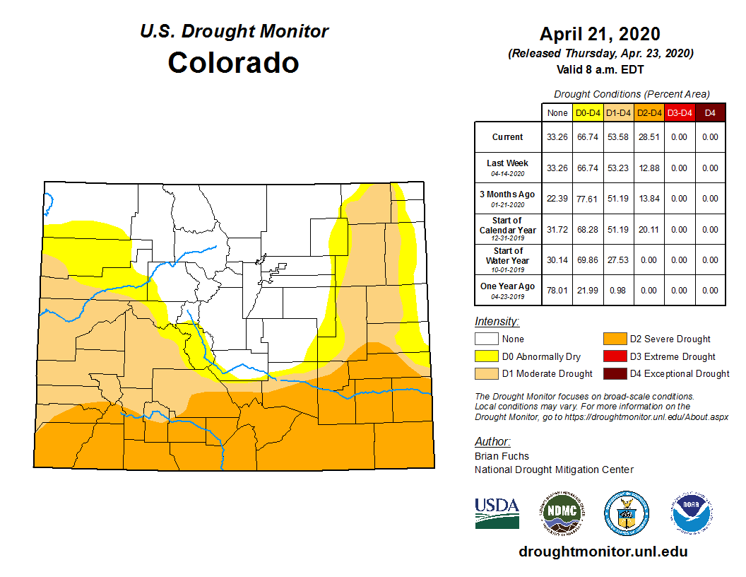
● The U.S. Drought Monitor, released April 23, shows gradual worsening conditions across all of southern CO compared to preceding months. D0 (abnormally dry) conditions cover 13% of the state; D1 (moderate) covers 25%; D2 (severe) drought covers 29% of the southern edge (up from 3% in March); 33% of the state (north-central) remains drought free.
Colorado Drought Monitor April 21. 2020.
● ENSO forecasts are still trending toward neutral conditions for spring and summer 2020, with a few model traces pointed toward La Nina.
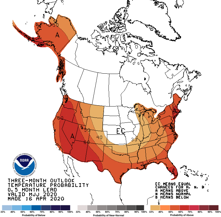
● NOAA’s Climate Prediction Center three month outlook maps show increased probability for warmer than average temperatures May through July for much of the state and favorable, slightly higher than average, precipitation outlooks for the Eastern Plains.
● Reservoir storage remains above average for all major basins except the Rio Grande (83%) and Arkansas (93%). Statewide, reservoirs are at 107% of average and 61% capacity.
● Long-term trends confirm our summers are getting hotter. The current seasonal forecast is a reflection of this.
● Water providers and water users did not report any unusual impacts or concerns at this time.
Arkansas Valley Conduit “A Path Forward” November 22, 2019 via Southeastern.
Here’s the release from the Southeastern Colorado Water Conservancy District (Chris Woodka):
Southeastern Colorado Water Conservancy District and the Bureau of Reclamation have adopted a project management plan that will guide construction of the Arkansas Valley Conduit (AVC).
The AVC is a pipeline project that will deliver clean drinking water to 40 communities serving 50,000 people from Pueblo Dam to Lamar and Eads on the eastern plains. This water supply is needed to supplement or replace existing poor quality water and to help meet AVC participants’ projected water demands. The estimated cost of the AVC is between $564 million and $610 million.
“The Project Management Plan is the blueprint for how we will build the Arkansas Valley Conduit, and an important step in the future of the AVC,” said Bill Long, President of the Southeastern District Board of Directors. “The AVC is absolutely necessary for the future water quality and health of the Arkansas Valley.”
“The Department of the Interior and Reclamation are committed to improving the water supplies of rural southeastern Colorado,” said Commissioner Brenda Burman. “I look forward to our continued collaboration with Southeastern to move this long-delayed project forward.”
“The communities of the Lower Arkansas Valley deserve clean drinking water, which the Arkansas Valley Conduit will supply for 50,000 Coloradans for generations to come,” said Senator Cory Gardner, R-Colo. “I was proud to secure robust federal funding of $28 million to begin construction for the first time since Congress authorized the project and President Kennedy promised completion nearly six decades ago. The project management plan adopted by the Bureau of Reclamation and the Southeastern Colorado Water Conservancy is another great step forward for this project and I’ll continue to work with local and federal leaders to ensure we deliver abundant and affordable clean drinking water to the Colorado communities in need.”
“This is a significant milestone in our efforts towards construction of the AVC,” said Jeff Rieker, Eastern Colorado Area Manager for Reclamation. “This plan will guide design and construction by Reclamation and Southeastern, and streamline our joint efforts to provide clean water to these communities.”
Reclamation and Southeastern have worked together for the past year to envision a layout for the AVC that reaches communities with the poorest water quality most quickly, reduces overall costs, and reduces the need for federal appropriations. Many communities have issues with radioactive elements in groundwater supplies. Others face increasing costs to treat water and to dispose of waste by-products from that treatment.
Under the plan, AVC water will be delivered to a point east of Pueblo by the Pueblo Board of Water Works. A contract among Reclamation, Pueblo Water and Southeastern is in the discussion stage.
From that point, Reclamation will construct the trunk line, a treatment plant and water tanks, while Southeastern will coordinate with communities to fund and build connections. Reclamation and Southeastern continue to meet regularly, using remote technology, to work on activities such as design, land acquisition and environmental review that will lead to construction.
“We’re on a path to begin construction in the near future, but we still have a lot of work to do,” said Kevin Karney, who chairs Southeastern’s AVC Committee. “Part of that will be reaching out to AVC participants to help shape how the AVC is developed. Overall, I’m excited to see the AVC moving forward.”
Congress provided additional funds to Reclamation in FY 2020. Reclamation allocated $28 million for construction of the AVC in February, and an additional $8 million for 2021 was requested in the President’s budget. The Colorado Water Conservation Board approved a $100 million finance package that still must be approved by the Colorado Legislature. Other potential sources of funding are being considered.
The AVC was part of the 1962 Fryingpan-Arkansas Project Act, but was never built because communities could not afford 100 percent of the costs. In 2009, the Act was amended to provide a 65 percent federal cost share. Reclamation identified a preferred alternative in 2014, which has been modified in the latest project management plan.
xxx
For additional information, contact Chris Woodka at Southeastern, (719) 289-0785; Darryl Asher at Reclamation, (406) 247-7608.
Fryingpan-Arkansas Project via the Southeastern Colorado Water Conservancy District
What sets this emerging megadrought apart from others, such as those recorded in the 1200s and 1500s, is that human activity is increasing the severity. Although past megadroughts had natural causes, the report found this natural phenomenon has been made worse by humans…
It’s important to understand the difference between deserts and droughts, said Kathy Jacobs, the director of the Center for Climate Adaptation Science and Solutions at the University of Arizona.
“I think making a distinction between sort of living in a desert where it’s hot and dry, and understanding that we could be entering into decades long shortage situations that really throw all of our water supply projections for a loop is a really important distinction,” Jacobs said.
To make that distinction, Williams and his team employed methods first used by researchers at the University of Arizona, in 1937 who discovered the width of the annual growth rings in tree trunks corresponded to moisture availabilities, or soil moisture.
“Our measurement of drought is really a combination of tree ring records that come up to 1900,” Williams said. “And then that, stitched together with our climate derived estimates of soil moisture, brings us up to 2018.”
He said a megadrought isn’t a multidecade period in which every year is dry, but instead an extended period when the occasional wet years don’t come close to making up for the predominance of dry years.
If the concept of an emerging megadrought seems abstract, there’s a reason. Williams said people might not immediately feel the impact of water sources depleting due to groundwater pumping in California, Arizona and other states…
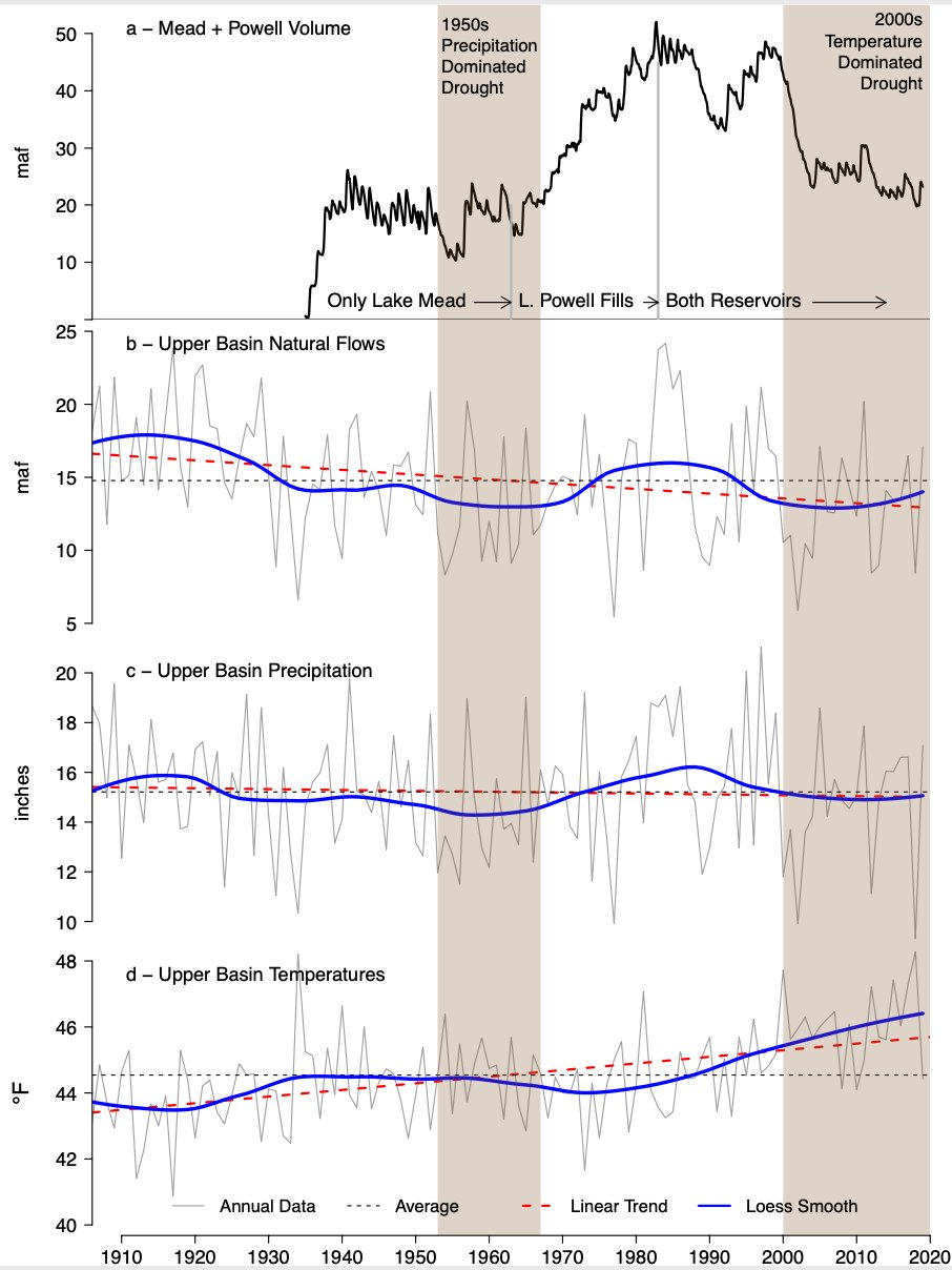
Brad Udall: “…latest version of my 4-Panel plot thru Water Year (Oct-Sep) of 2019 of the #coriver big reservoirs, natural flows, precipitation, and temperature. Data goes back or 1906 (or 1935 for reservoirs.) This updates previous work with @GreatLakesPeck
The Colorado River is one example of decreasing water resources. Arizona, California, Colorado, Nevada, Utah, Wyoming and New Mexico depend on the river for water, but the amount of water each state is promised has been consistently overallocated…
“The fact that the normal average year is actually getting drier and is projected to keep getting drier in the Colorado River means that we’re probably going to have to revise how much each state is allocated on the Colorado River substantially,” Williams said.
Beyond that, Jacobs stresses the need to elect representatives to the Arizona Legislature who care about the environment and to reach out to current legislators so they know how important tighter water regulations are to Arizonans and the state’s economy…
“The stakes for humans are higher than they’ve ever been before,” Williams said. “And as we change the climate, one of the things that is most predictable is that the distribution of water is going to change. Trying to figure that out before it really becomes a crisis, I think, is one of the most valuable things we can do.”
As the U.S. struggles to control the COVID-19 pandemic, some experts have suggested that we can learn something about how to address climate change from this crisis.
The same thing is already happening with climate change. When entrepreneurs offer solutions that create simultaneous ecological and economic benefits, it is called “environmental entrepreneurship.” My research shows that such entrepreneurship happens in three ways.
First, successful environmental entrepreneurs tend to see themselves as both environmentalists and businesspeople. Because of this, they often recruit investors, employees and customers from a broader group than traditional startups. Some offer a hope of reducing carbon emissions through new technologies. Others are small business heroes, creating jobs and building new industries.
Second, environmental entrepreneurs are attuned to different signals than large firms are.
While they are encouraged by environmentalist beliefs, we have also found that the importance of family can predict the number of environmental entrepreneurs in a state. Our research shows that solar energy companies are more likely to form in states that value not only the environment, but also family relationships.
Further, while large firms tend to respond to government-driven policy and economic indicators, environmental entrepreneurs respond to more subtle signals, such as local values. In the green building industry, environmental entrepreneurs ignore economic indicators, but are encouraged by local beliefs and activism. In short, they move first, taking on risk before the evidence is in.
Third, environmental entrepreneurs make a difference. We looked at the effect of various policies, activism and business practices on the adoption of new technologies like green building and renewable energy. We then divided the U.S. into more politically conservative and liberal regions to see whether policies, activism or business practices mattered more under different norms.
We found that the only consistent factor that increased green building adoption in both types of political environments was the number of environmental entrepreneurs. These findings suggest that when a critical mass of entrepreneurship occurs, the political divide on climate change fades away, and we see a rapid uptick in adoption of environmentally beneficial practices.
Solar entrepreneurship thrives in states that value the environment and families. AP Photo/Mark Lennihan
Here’s what I’d suggest. Laser-focus on the creation of new small businesses as a way to rebuild, offering consulting, technical training and tax incentives.
By focusing on new ventures, those on both sides of the political aisle can rebuild an economy focused on long-term environmental sustainability and economic stability.
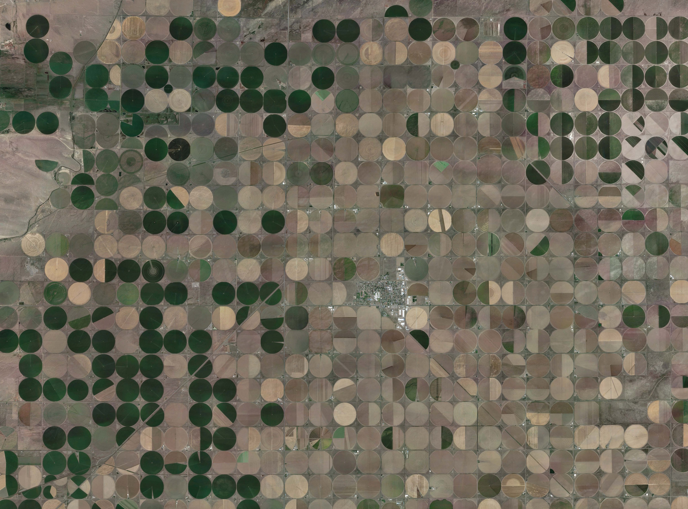
Center, Colorado, is surrounded by center-pivot-irrigated farms that draw water from shrinking aquifers below the San Luis Valley. Photo credit: Google Earth
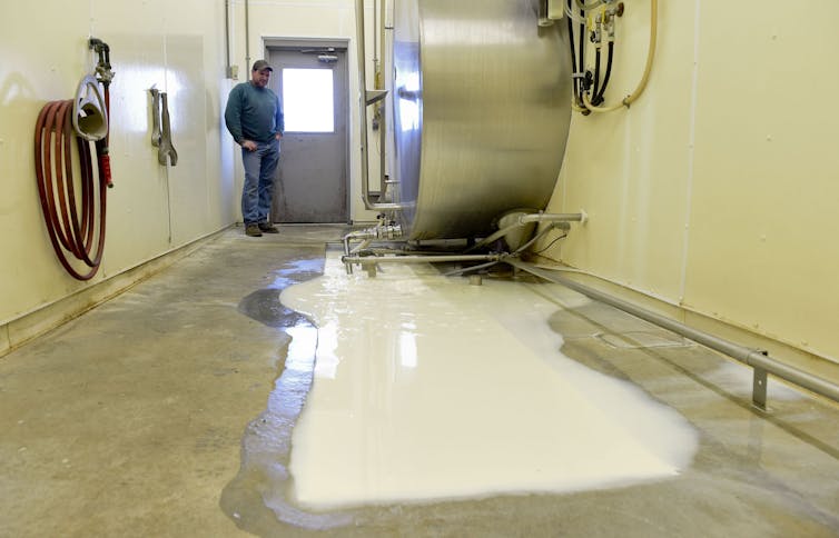
House Agriculture Committee Chairman Collin Peterson, D-Minn., said today that he is so horrified by the government’s response to agriculture and food amid the coronavirus pandemic that he will conduct a broad investigation into the Agriculture Department’s powers and propose legislation to deal with future situations such as the arrival of African swine fever in the United States.
Noting that his callers who ask why farmers are dumping milk, plowing under fruits and vegetables and euthanizing animals included actor Richard Gere, Peterson told reporters by telephone, “I am sick and tired of answering questions that I can’t answer. After this is over, we will have an answer or I won’t be chairman of the ag committee anymore.”
Peterson also said that he will propose increasing the budget for the Agriculture Department’s Commodity Credit Corporation, a line of credit at the Treasury used to aid farmers in distress, from $30 billion per fiscal year to $68 billion, but only if the legislation requires that the agriculture secretary seek approval from the chairs and ranking members of the House and Senate Agriculture committees before spending the money.
Peterson noted that CCC’s allowance to spend $30 billion per year with automatic reimbursement from Congress was established in the 1980s and that the $68 billion would allow the account to keep up with inflation. Peterson said House Speaker Nancy Pelosi, D-Calif., would support the proposal and that Senate Agriculture Committee Chairman Pat Roberts, R-Kan., told him that he believes there would be support for the idea in the Senate.
The South Platte River runs by a utility plant near I-25 in Denver. The South Platte River runs by an electricity plant near I-25 in Denver. A project proposed by the South Platte Regional Opportunities Water Group would allow Front Range water managers to maximize the reuse of Colorado River water. Photo credit: Lindsay Fendt/Aspen Journalism FromAspen Journalism (Lindsay Fendt):
A multibillion-dollar reservoir and pipeline project may one day pull more than 50,000 acre-feet of water per year from the South Platte River before it reaches Nebraska. That’s more than 16 billion gallons of water, enough to fill 25,000 Olympic-sized swimming pools.
The possible project is laid out in a new report from the South Platte Regional Opportunities Water Group, or SPROWG, a group of water managers from the Front Range. If built, the project would enable Front Range water managers to repeatedly reuse water diverted from the Colorado River, something Western Slope water managers have long encouraged and see as a welcome shift.
Colorado transmountain diversions via the State Engineer’s office
“There is a lot of fully reusable water that makes its way down the South Platte,” said Eric Kuhn, a retired manager of the Colorado River Water Conservation District who now writes about Colorado River issues. “This is something that people on the Western Slope have been trying to encourage for probably 70 years.”
The group used a $350,000 grant from the Colorado Water Conservation Board and the South Platte Basin and Metro Basin roundtables to complete the year-long study, which was released in March. The group members hope the project could help close a water-supply gap of as much as 540,000 acre-feet that the state is projecting for the South Platte River basin by 2050.
Since the 1930s, Front Range water planners have looked west to bolster their water supplies. An elaborate series of reservoirs, underground tunnels and pipelines now conveys about 400,000 acre-feet of water annually from the Colorado River headwaters to the South Platte basin.
Water is diverted from the Colorado, Fraser, Blue, Eagle, Fryingpan and Roaring Fork rivers in Grand, Summit, Eagle and Pitkin counties and sent under the Continental Divide to the South Platte basin.
Large projects on the South Platte were previously written off due to the high costs of water treatment, but as the cost and controversy surrounding transmountain diversions have grown, a project such as SPROWG — which would have seemed expensive decades ago — is now on par with most other supplies of water. Depending on which concept configuration is used and whether the water will need to be treated, building the project would cost between $1.2 billion and $3.4 billion to build.
The South Platte River runs near a farm in Henderson, Colorado, northeast of Denver. Henderson is the site of one of the possible reservoirs for the regional water project proposed by SPROWG. Photo credit: Lindsay Fendt/Aspen Journalism
Use to extinction
Each of SPROWG’s storage concepts would capture stormwater and native South Platte water during wet years. While the project would not be used to store water from existing or future transmountain diversions, it would capture water from the Colorado River that made its way back to the river as a return flow after being used elsewhere within the basin.
“SPROWG is not intended to store supplies from an existing or new transmountain diversion project (though it will provide a means to utilize unused reusable return flows from transmountain diversions),” the report said.
Once water is transferred over the mountains to the Front Range, it can legally be used to extinction, meaning that it can return to the river as runoff, be recaptured and be used again perpetually. By decree, certain volumes of Colorado River water can only be reused within a certain area, something the SPROWG project would need to ensure.
“If they are going to take the water in the first place, they should make sure they are reusing that water to the full extent possible,” said Andy Mueller, general manager of the Colorado River Water Conservation District, which was formed in 1937 to protect Western Slope water.
Although the SPROWG project does not require more water from the Western Slope, it is not considered a replacement supply for any of the existing water that the region takes from the Colorado River system. Despite the continued need of existing transmountain diversions, Mueller sees the project as an acknowledgement by at least some on the Front Range that the Colorado River is no longer a feasible option for future water supplies.
“I think there are a number of operators of Front Range systems that recognize that the Colorado River system has hit its limit,” he said.
While Western Slope water managers interviewed for this story were all generally supportive of the project, the Colorado Basin Roundtable, which represents different water districts and users within the basin, has not yet taken a formal opinion on it.
Conceptual projects outlined by SPROWG will allow water managers to reuse Colorado River water. Three of the four project alternatives include an approximately 80-mile pump-and-pipeline system that would move water from a reservoir in Balzac, northeast of Denver, uphill to the metro area. Graphic credit: SPROWG
Conceptual project
The concepts outlined in the report are still far from a fully formed project, as no steps have been taken toward permitting, acquiring land or even identifying a user for the water. But SPROWG members hope that the analysis could be the first step toward a basinwide water project, a cooperative effort not typical of other large water projects.
“It just seems like something that we need to do, organizing the basin and helping the basin function as efficiently as possible,” said Matt Lindburg, SPROWG’s senior engineering consultant. “It will definitely be a project and concept that folks want to pursue.”
The report analyzed four possible storage and pipeline configurations that would collect agricultural water returned to the lower South Platte as runoff from the region’s farms, and then pump it back to the Denver metro area.
Three of the four project alternatives include an approximately 80-mile pump-and-pipeline system that would move water from a reservoir in Balzac, northeast of Denver, uphill to the metro area. The pipeline would allow the metro area to reuse some water that it already returned to the river as runoff or through water-treatment plants. The conceptual reservoirs could store between 220,000 and 409,000 acre-feet of water.
The idea to design a basinwide water project came from conclusions in the South Platte Storage Study, a 2018 analysis of basin-water supplies that was funded by the Colorado legislature.
That study found that the state was sending an average of 293,000 acre-feet more water down the South Platte and into Nebraska than what is required by the South Platte River Compact, an agreement between the two states that governs how much water Colorado is able to take from the river.
The SPROWG project would be designed to capture some of this water while remaining within the confines of the compact. The report suggested that water could be reused rather than the basin continuing to rely on either Western Slope or agricultural water.
In recent decades, agriculture along the South Platte has been the other main source of water for growing municipalities. Municipal governments buy out farms with senior water rights and dry up the fields, sending the water to the cities.
“This is probably the only other option on the table,” said Joe Frank, general manager of the Lower South Platte Water Conservancy District. “We want to do as much as we can to minimize the pressure on those other sources of water.”
The report also shows that the cost of the water from the projects would be consistent with other projects in the region — between $18,400 and $22,600 per acre-foot for untreated water and between $33,600 and $43,200 for treated water.
Whether cities will need additional South Platte water in the future, some of it is already spoken for. In March, 600,000 cranes — 80% of the world population — will visit an 80-mile stretch of the mainstem of the Platte River in Nebraska, where the birds fatten up on grain before a long migration north. Water flowing in the river makes this spectacle possible.
Even if the SPROWG concept were built, it would need to work within the confines of the Platte River Recovery Program, which was created to help protect these cranes and other endangered species on the river.
The recovery program, which secured additional water and land for habitat, has led to a dramatic increase in the population of endangered birds during migration season in Nebraska. SPROWG’s designers say they would work within the program, timing reservoir releases and saving water for specific ecological needs, but the report does not include a full environmental analysis.
Aspen Journalism is a 501(c)(3) nonprofit organization covering water and rivers in collaboration with The Aspen Times and Swift Communications newspapers. This story ran in the April 25 edition of The Aspen Times.
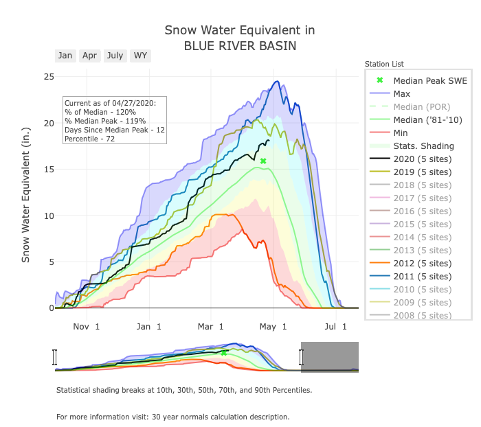
Despite a drier spring than Summit County saw last year, the Blue River basin’s snowpack total is well above the seasonal average. Treste Huse, a senior hydrologist for the National Weather Service in Boulder, said the Blue River basin sits with 120% of the average for snow-water equivalent, or how much water is held in the snowpack.
Huse said the water in the Blue River basin snowpack is well above average for this time of year. The snowpack in the basin holds about 19.3 inches of water, compared with the average 15.7 inches of water that the basin’s snowpack typically holds this time of year…
Colorado Drought Monitor April 21. 2020.
Huse said that the majority of storms this year have come from the northwest and have favored the north central mountains, missing the southern mountains. The U.S. Drought Monitor’s national drought summary, which was last recorded April 21, reports that severe drought has expanded over most of southern Colorado. The Colorado Climate Center at Colorado State University’s April 21 update lists the eastern plains of Colorado as an area of concern and reported that snowmelt in the Four Corners region has “kicked into high gear” and is melting faster and earlier than normal…
Going over the year in precipitation amounts, Huse said Summit County had a good October, November was fairly dry and then precipitation accumulation amounts shot up in December. She reported that February into March was great for precipitation as February saw record snowfall amounts at some of the ski areas.
Precipitation has leveled off in April with small storms bringing little accumulation aside from one recent storm system that brought 1.4 inches of snow-water equivalent. Huse said the snowpack levels were above average going into April, but the recent storm helped bring the numbers even higher.
Blue River snowpack April 27, 2020 via the NRCS.
The Blue River basin nears the end of the precipitation cycle toward the end of April. Huse said the weather service looks at yearly precipitation from July 1 through the end of June. She said that on April 17, Dillon’s total snowfall was around 102.1 inches while normal seasonal snowfall is 107 inches, putting Dillon just a few inches shy of the average snowfall total but ahead of average for mid-April. Huse said that at this time of year, the average snowfall amount in Dillon is 94.5 inches.
As she reported in early March, Huse said snowfall totals are above average but not abnormal. She said this is the 77th highest amount of snowfall for a year in Dillon out of 112 years. The highest annual snowfall Dillon has recorded was in 1935 when the town saw 227 inches of snow.
While water in the snowpack is above average this year, Huse said the late-season precipitation is not nearly as high as 2019, which was an anomaly. She reported that while the snow-water equivalent is around 19.3 inches this year, in 2019 the Blue River basin had around 21.2 inches.
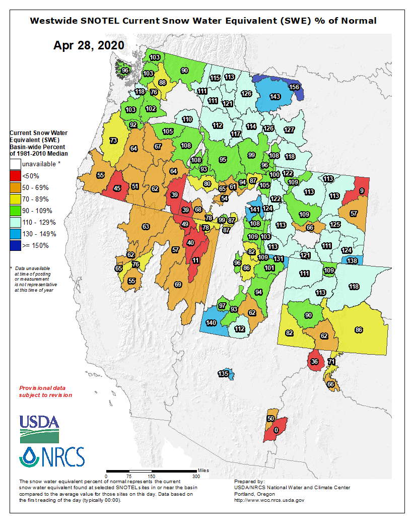
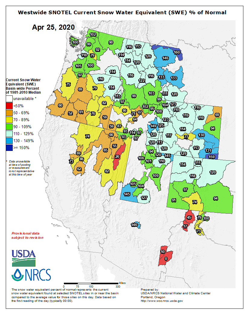
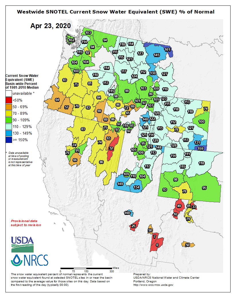
Westwide SNOTEL basin-filled map April 28, 2020 via the NRCS.
Photo credit from report “A Preliminary Evaluation of Seasonal Water Levels Necessary to Sustain Mount Emmons Fen: Grand Mesa, Uncompahgre and Gunnison National Forests,” David J. Cooper, Ph.D, December 2003.
Environmental activists got an unwelcome gift from the federal government on the eve of the fiftieth anniversary of Earth Day, when officials with the Environmental Protection Agency revoked clean-water protections for thousands of streams across Colorado. Now advocates and state officials are taking President Donald Trump’s administration to court.
One of many bedrock environmental laws targeted for rollbacks by the Trump administration, the Clean Water Act has protected the “waters of the United States,” including rivers, lakes, streams and wetlands, since its passage in 1972. But a rule change announced by the Trump administration on April 21 would dramatically narrow the definition of those “waters,” removing protections for many wetlands and smaller, intermittent streams, and potentially threatening ecosystems and drinking water supplies…
The EPA’s decision will hit especially hard in Colorado and other Western states where water is already a precious resource. The new rule excludes all “ephemeral” streams, which only flow after rainfall or snowmelt, and some “intermittent” streams, which only flow for part of the year. An estimated 55 percent of streams in Colorado are classified as intermittent or ephemeral, according to conservation group Trout Unlimited…
Under the new rule, which will formally take effect on June 20, developers and industrial interests will be able to build in many wetland areas or near ephemeral streams without applying for Clean Water Act permits. That could dramatically speed up construction of projects like oil and gas pipelines, while environmental-review processes are significantly weakened.
“Lobbyists for corporate agribusiness, developers, and the oil and gas industry have long demanded that federal protections be removed for streams and wetlands,” says Hannah Collazo, director of Environment Colorado. “This is just plain wrong. Clean water is vital for our health, our way of life, and for nature itself.”
Environmental groups have already announced plans to sue over what they call Trump’s “Dirty Water Rule,” and so has Colorado Attorney General Phil Weiser, who said in a statement that the administration’s decision is “based on flawed legal reasoning and lacks a scientific basis.”
Here’s a guest column from Manfried Diehl that’s running on the Colorado State University “Source” website:
Manfred Diehl, Professor, Human Development and Family Studies, College of Health and Human Sciences, Colorado State University, October 14, 2016
Researchers who are studying the human aging process from a behavioral perspective are getting increasingly concerned that their efforts to reduce ageism in our society are being rapidly undone during the COVID-19 crisis. Ageism includes the propagation of negative age stereotypes, discrimination against older adults, and stigmatization based on age.
Here are five ways in which the COVID-19 crisis has also created an ageism crisis that requires everyone’s attention.
1. In public discussions, older adults are regularly referred to as “the elderly.” The use of this word is viewed as derogatory in nature by many professional organizations, including the Gerontological Society of America and the American Psychological Association. The reason for that is that the word “elderly” invokes images of frailty, vulnerability and senility. Yet, the overwhelming majority of older adults (e.g., persons over the age of 60 or 65) are neither frail, vulnerable or senile. Indeed, the majority of older adults lead vigorous and productive lives.
2. The public discussions also ignore that a person’s age is, in general, not a good indicator of that person’s level of functioning, and that older adults are the most diverse age group in our society. Therefore, a person’s age should not become the sole criterion for whether this person receives testing or treatment during the COVID-19 crisis. Other criteria, such as a person’s symptoms, preexisting health conditions, and other risk factors should become the decisive factors – for both older and younger adults. Indeed, it is important to not withhold important health care from younger adults (e.g., reversed ageism) with the argument that they are reserved for older adults. Such an approach only sows intergenerational division where intergenerational solidarity is needed.
3. Although the public emphasis on older adults’ greater susceptibility to COVID-19 may be well-intentioned, it is also important to keep in mind that it is not age per se that makes older adults more susceptible. Rather, it is the co-morbidities that are more likely to happen as individuals get older that make a person more vulnerable. For example, a 50-year-old with asthma, type 2 diabetes, and cardiovascular disease may be more vulnerable to the COVID-19 virus than a healthy 70-year-old. Again, age alone is just a number and we should not stigmatize anybody because of that number.
4. Another aspect of ageism that has reoccurred in public debates is the “greedy old geezer” argument. That is, older adults may create a disproportional burden on societal resources, such as the health-care system, that would be better invested in younger generations. Although it is correct that the rate of hospitalizations and fatalities is higher for older adults, currently it is not clear at all whether this is also the case for the rate of infections. As the pandemic unfolds, it may well be that the rate of infections will actually turn out to be significantly higher in younger age groups. This is another reason why it is important to refrain from blaming the old and to engage in intergenerational solidarity. Let’s face it: We are all in this together!
5. Finally, it is important to acknowledge that many older adults are making valuable contributions to their communities during the COVID-19 pandemic. Increasingly we are hearing stories that retired nurses and doctors are responding to the needs of their local communities and help provide services in testing lines, emergency rooms, and on hospital floors. Other activities that older adults are contributing to in their communities is helping with the production of protective gear, helping with child care, and serving as caregivers to loved ones. Again, it is important to acknowledge these valuable contributions and to refrain from thinking that “old = worthless.”
In summary, behavioral aging researchers advocate for a balanced portrayal of older adults in our society and remind us that later adulthood is a life stage that we all – if we have the good fortune to live long enough – will experience at some point in time.
Manfred Diehl is a University Distinguished Professor in the Department of Human Development and Family Studies, which is part of CSU’s College of Health and Human Sciences.
Click here to read the newsletter. Here’s an excerpt:
HPRCC Staff Conduct Climate Summary Workshop for Tribes in the Region
As part of a Bureau of Indian Affairs-funded tribal resilience project, HPRCC staff developed and conducted the “Lower Missouri River Tribes Resilience Training Climate Summary Workshop” in mid-March for tribal environmental professionals from nine tribes in EPA Region 7: Iowa Tribe of Kansas and Nebraska, Kickapoo Tribe in Kansas, Omaha Tribe of Nebraska, Ponca Tribe of Nebraska, Prairie Band Potawatomi Nation, Sac and Fox Nation of Missouri in Kansas and Nebraska, Sac and Fox Tribe of the Mississippi in Iowa, Santee Sioux Tribe of Nebraska, and Winnebago Tribe of Nebraska. The workshop was one in a series of workshops that are part of a larger project aiming to increase tribal resilience to climate change and extremes. While the workshop was supposed to take place on the Winnebago Reservation in Sloan, IA, the workshop ended up being conducted remotely via Zoom due to the COVID-19 pandemic.
The workshop began with a series of presentations that introduced participants to basic climate concepts, the climate of the region, including trends and projections, and the process for creating a climate summary. Much of the rest of the workshop was hands-on, as participants had the opportunity to explore tools and obtain data on general climate conditions, drought and vegetation, stream- flow and snowpack, and climate outlooks.
Tune into the 24th episode of our podcast: We Are Rivers. Learn all about Colorado’s instream flow program, and the significance it has on surrounding rivers and communities.
The Yampa River Core Trail runs right through downtown Steamboat. Photo credit City of Steamboat Springs.
Join us for Episode 24 of We Are Rivers, as we de-wonk Colorado’s instream flow program, a critical tool to protect and enhance river flows across the state of Colorado.
Rivers form the lifelines of Colorado’s economy and lifestyle. On both sides of the Continental Divide, rivers provide world class fishing, paddling and fantastic scenic canyons. Not only do rivers provide engaging recreation opportunities, they also provide most of Colorado’s clean, safe, reliable drinking water, support our thriving agricultural communities, and substantially contribute to Colorado’s culture, heritage, and economy.
Recognizing the importance of rivers and the fact that the state needed to correlate the demands humans place on rivers with the reasonable preservation of the natural environment, Colorado established its Instream Flow Program in 1973. This program allows the Colorado Water Conservation Board (CWCB) to hold instream flow water rights – a legal mechanism to keep water in a specific reach of a river – to preserve or improve the natural environment of a stream or lake. The CWCB is responsible for the appropriation, acquisition, protection and monitoring of instream flow water rights.
The CWCB is the only entity in the state that can hold an instream flow water right, however many different entities including cities, agriculture, recreation and the environment benefit from instream flow water rights. In this episode of We Are Rivers, we explore the benefits of the program and discuss the important partnerships and collaborations that occur between different water users.
Take for example the City of Steamboat Springs. The 2002 and 2012 droughts significantly reduced flows in the Yampa River, impacting all water users. In 2002, the river experienced some of its lowest flows on record. River sports shops closed their doors, there was a voluntary ban on angling, and farmers and ranchers had less water. The river and the community suffered. Flash forward to 2012, and the community faced similar drought conditions. But partners got creative, and used the instream flow program to bolster flows in the Yampa River, preventing history from repeating itself. This partnership included the CWCB, Colorado Water Trust, and Upper Yampa Water Conservancy District. Together, they temporarily leased water from Stagecoach Reservoir, improving flows in the Yampa through the City of Steamboat. The short-term leases from Stagecoach Reservoir were vital to the health of the Yampa River and its surrounding communities, and were used not only in 2012, but also 2013 and 2017. This is just one example of how a diverse set of partners came together and utilized the instream flow program for many benefits.
The instream flow program underwent an exciting expansion earlier this year that will provide more opportunities for communities to benefit from collaborative instream flow solutions. After a multi-year stakeholder effort, the Colorado Legislature passed a bill to expand Colorado’s existing instream flow loan program – HB20-1157. The law expands protection of rivers without threatening or hindering existing water rights. It authorizes a targeted expansion of the loan program that makes the program more useful to water right owners and benefits Colorado’s rivers and streams. Specifically, it adjusts the amount of time a user can exercise a renewable loan from 3 years out of 10, to 5 years out of 10 years and it allows water right owners to renew participation in the program for up to two additional 10-year periods, for a total of 30 years. This is a huge opportunity for rivers and communities: take, for example, the benefit this provides to the Yampa River. The partners working together to secure the 3 in 10 instream flow loan on the Yampa through the city of Steamboat Springs now have two additional years in this 10-year period where water can be leased under the expanded program. Future climate conditions make frequent droughts more likely, and the opportunity to curb impacts during those back-to-back drought years is another important and timely benefit of the expanded ISF program.
The complexity of Colorado Water Law is a lot to digest, and the instream flow program is no exception. We hope you join us for Episode 24 to break down the specifics of the instream flow program and what it means for rivers and communities.
Yampa River Basin via Wikimedia. Ranchers and farmers in the valley have largely ignored Division Engineer Erin Light’s order to install measuring devices as of December, 2019.
A flight from NASA’s Airborne Snow Observatory gathers data about the snowpack above the reservoir on a June 24 flight. Information gathered from the flight helped Denver Water manage reservoir operations. Photo courtesy of Quantum Spatial
From the Colorado River District via The Rio Blanco Herald-Times:
A growing body of research shows that the Upper Colorado River Basin is growing warmer on average. In fact, the national hot spot centers on Western Colorado and much of the Southwest.
A result: a significant reduction in the snowpack that makes up the Southwest’s main water supply.
In the Colorado River District’s “Know Your Snow” webinar, Deputy Chief Engineer Dave Kanzer and National Snow and Ice Data Center researcher Jeff Deems explored how water managers and snow scientists are studying and adapting to the changes to our snowpack and water supply.
About three-quarters of the snowmelt that forms the Colorado River’s flow falls as snow at elevations above 8,500 feet in the mountains of the Upper Colorado Basin, Kanzer explained. Deems pointed out that the 15 Western Slope counties that make up the Colorado River District have warmed at a rate from about 2 degrees Fahrenheit in Summit County to more than 4 degrees in Mesa, Montrose, Ouray and Rio Blanco counties since about the early 1900s, according to data developed by the National Oceanic and Atmospheric Administration.
“We’re seeing changes on the order of 4 or 5 degrees in parts of the District,” Deems said. “This is just a slice out of this big, warming bullseye that is hitting the Upper Colorado (River) Basin over that time period. This is a problem for us because we rely on the snowpack, and that’s because warming reduces stream flow through a number of different mechanisms in this snowmelt-dominated basin.”
That reduction comes from several factors: more snow falling as rain, earlier spring snowmelt, more snow directly evaporating into the atmosphere instead of melting into streams and a longer growing season that has plants taking up more water.
Deems explained that for every 1 degree of warming, there is an estimated 3 to 4% decline in annual runoff. That’s about double the amount of water Las Vegas uses in one year, and 18 months of water supply for the city of Los Angeles, Deems said.
A recent study by the U.S. Geological Survey found that a decline in flow due to warming is even greater than earlier studies have shown, with statistics suggesting that average annual flow decreases by 9.3% for every 1.8 degrees of warming.
All of this poses a threat to drinking water, irrigation to grow our food and water to maintain healthy wildlife habitats. The Colorado River District is not only studying the water-supply risks posed by warming temperatures but also implementing solutions such as cloud seeding to make sure West Slope communities are prepared for future challenges.
Cloud-seeding graphic via Science Matters
Cloud seeding to increase snowpack
As part of an effort to boost snowpack, Kanzer coordinates the Colorado River District’s cloud seeding program. Increasingly, water managers are turning to cloud seeding, a practice that can increase how much snow winter storms produce.
“We’re trying to figure out how to mitigate and adapt to a changing world,” Kanzer said. “We’re doing this through cloud seeding, and (we’re) implementing these programs throughout Western Colorado. In fact, this is going on throughout the West and throughout the world.”
Cloud seeding requires a specific set of conditions to be successful, Kanzer explained. A cloud must contain super-cooled water. Water vapor in these clouds is cold enough to form ice crystals, around 5 to 23 degrees Fahrenheit, but it needs something on which to crystalize. When conditions in a storm system are right, with favorable winds with proper uplift, cloud seeding generators send tiny particles of silver iodide into the moisture-laden clouds, typically using propane-fired burners on the ground.
Silver iodide has been proven to be safe for the environment, Kanzer said, adding that it is effective because and it naturally has a similar crystal structure to the ice crystals that form snowflakes.
The super-cooled liquid water more efficiently freezes on to these introduced tiny particles of silver iodide, building small ice crystals that grow into snowflakes.
Kanzer said cloud seeding could increase snow on the ground by up to 15%, boosting what might have been a 10-inch snowstorm by 1.5 inches. After a successful season of cloud seeding, this might, in turn, lead to as much as a 5% increase in streamflow in watersheds where cloud seeding occurred. This increases recreation opportunities for skiers in the winter and boaters in the warmer months, he added.
“And it helps us with our water supplies, of course, and that’s what we’re really focused on here at the Colorado River District,” Kanzer said.
This map shows the snowpack depth of the Maroon Bells in spring 2019. The map was created with information from NASA’s Airborne Snow Observatory, which will help water managers make more accurate streamflow predictions. Jeffrey Deems/ASO, National Snow and Ice Data Center
Improving predictions with better data
While Kanzer’s work focuses on increasing the amount of snowpack, Deems’ research seeks to better understand what snow we have.
He explained that water supply forecasts are traditionally generated by comparing the current amount of snow on the ground at fixed locations to historical streamflow records. With the changes we are experiencing, Deems said these methods of comparing the present to the past are no longer accurate.
Additionally, snowpack is measured by a network of weather stations widely spread out across the mountain landscape where Colorado’s snowfall accumulates. While these stations provide accurate measurements in very specific locations, they don’t indicate how much snow, and how much water, might be stored high in the mountains, above the elevations where these stations are located.
Deems’ company, the Airborne Snow Observatory, uses a system called light detection and ranging — LIDAR for short — to measure snow across the entire landscape. From a plane, Deems’ team sends pulses of scanning laser light toward the earth, which reflect off the snow. Researchers can then use information in the reflection to build a three-dimensional picture of the snowscape.
This technology gives snow scientists and water planners landscape-based information about how much snow, and water, is present. This technology is detailed enough to reveal the deep pockets of snow below bare slopes where avalanches occurred or even areas where snowmaking was used to make terrain parks on a ski run.
This more comprehensive of the snowpack significantly improves water supply forecasts critical to water managers in making decisions.
Together with cloud seeding, this technology is helping water managers turn the corner from historical practices to prepare for and adapt to a changing world in the Upper Colorado River Basin.
Screen shot from this episode of “Tom Talks” April 2020.
Here’s a great stay-at-home video from Tom Cech at the One World One Water Center at Metropolitan State University of Denver (Go Roadrunners!)
“Join us in welcoming MSU Denver’s Dr. Matthew Makley on our second TomTalks! Dr. Makley teaches us about the Hohokam people and their relationship to water in the arid American West.”
West wall of the Casa Grande ca. 1880. “Casa Grande” is Spanish for “big house” (Siwañ Wa’a Ki: in O’odham); these names refer to the largest structure on the site, which is what remains of a four-story structure that may have been abandoned by 1450. The structure is made of caliche, and has managed to survive the extreme weather conditions for about seven centuries. The large house consists of outer rooms surrounding an inner structure. The outer rooms are all three stories high, while the inner structure is four stories high. The structures were constructed using traditional adobe processes. The wet adobe is thicker at the base and adds significant strength. Photo credit: By National Forest Service – http://www.nps.gov/cagr/photosmultimedia/Historic-Photos.htm, Public Domain, https://commons.wikimedia.org/w/index.php?curid=16977952Arizona Rivers Map via Geology.com.
First, on behalf of the Gunnison River Basin Roundtable (GRBT) I want to thank everyone involved in putting this monthly newsletter out! This is the inaugural greeting from the Chair of the GBRT and we hope to make this a monthly feature of the Gunnison Basin Newsletter.
I think, now more than ever, that it is critical to expand communications from the water community. The threats we face are growing, especially now as we are in the throes of Covid-19 response measures.
Where does the water community fit in as we all wrestle with the uncertainty, fear, frustration, and the economic devastation associated with the Covid-19 pandemic?
Water supply and water management clearly fall into the “Essential Services” category. Drinking water still needs to be delivered, even if some customers can’t afford to pay their bills. Wastewater still needs to be treated, regardless of the financial crunch. The world needs to be fed. Crops need to be planted, water needs to be diverted, infrastructure needs to be maintained, the work goes on.
From a Gunnison basin perspective, I am thankful that the runoff should be near average (can you imagine if we had a severe drought on top of all that is currently happening?!) the creeks are starting to run, the Gunnison Tunnel is diverting, irrigators are hard at work getting their water into the fields, crops are emerging, calves are being born, and the agricultural sector remains the backbone of our economy, paying its employees, supporting local hardware stores, implement dealers, coops and more.
On the municipal side, clean, safe drinking water is being treated and delivered to thirsty customers. Wastewater operators are keeping our rivers clean. And we are all banking on a future that looks like some kind of return to normalcy. One that is marked by selling annual crops and cattle at a decent market price, providing our citizens with high quality meat and produce and enabling folks to enjoy the way of life we have come to appreciate, and love, in our basin.
But anxiety persists. “What if the commodity markets collapse?” “What if our customers can’t pay their bills?”
The situation is worsened because we have little or no control over worldwide market forces that could cause a major, market collapse.
Fortunately, there is something that we can do individually and collectively – our actions can help limit the spread of the disease. Work from home and stay at home when possible. Don’t stand close to anyone, wear a mask, wear gloves. Take special care with vulnerable populations, be patient.
I REALLY feel for all of the folks that are out of work, and the small businesses that may never re-open and the lost loved ones and the scariness of this disease.
As all of us in the Gunnison Basin do our best to move forward with our lives, let’s hope that we can keep the timeframe on this disruption to a minimum. – Kathleen Curry, Gunnison
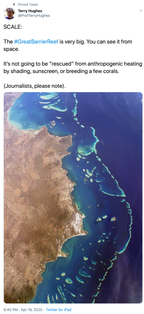
Throughout the 2000s, grim reports of crumbling, pale corals multiplied, arriving from remote South Pacific atolls, the Indian Ocean, the Red Sea and, once again this year, from Australia’s Great Barrier Reef, where the overheated Pacific Ocean scalded corals for the third time in five years. The renewed bleaching of the world’s largest reef confirms that coral reefs globally are in big trouble, said scientists, many of whom reported that their dismay has been compounded by government failures to protect collapsing coral-based ecosystems despite decades of warnings.
In the Caribbean, global warming has already pushed some reef ecosystems over a climate cliff. Today’s underwater landscapes are nearly unrecognizable for scientists and divers who started visiting them 50 years ago, said University of Windsor coral reef ecologist Peter Sale.
“What we are doing to coral reefs is akin to eliminating all the rainforests on the planet,” he said. “Coral reefs are probably going to be the first globally distributed ecosystem wiped off the face of the Earth by humans.”
Corals bleach when the water they inhabit gets too warm, and they shed the pigmented algaes that provide them with food through photosynthesis. The affliction isn’t always fatal. Depending on the intensity of the event, reefs can partly recover in a decade, but lately, the waves of bleaching have come so fast that there’s no time for recovery, Sale said. Mass coral reef bleaching has become five times more common in the past 40 years, research shows.
Since the first global bleaching event in 1998 shocked coral scientists with its reach and intensity, subsequent die-offs affected reefs in regions with no known history of bleaching, including some in Hawaii. Sale said that, even if global warming is capped at the limit set by the Paris climate agreement, 90 percent of the planet’s reefs will disappear.
“Reefs are toast if we let warming get much above 1.5 degrees Celsius (2.7 degrees Fahrenheit),” he said. “I am surprised at the fact that the bleaching of coral reefs has not evoked the response from society that I would have thought. Since 1998, scientists all assumed it would be a huge wakeup call to do something. We’ve been surprised and disappointed.”
It’s not for lack of trying. The most recent key reports from the International Panel on Climate Change included stark warnings about the reef death spiral and urged immediate, significant cuts of greenhouse gas pollution to avert their annihilation.
The world’s failure to act decisively to avoid mass global coral extinctions is anguishing for Australian coral reef scientist Terry Hughes. His annual surveys of the decline of the Great Barrier Reef have led him to publicly spar with his own government and with Rupert Murdoch-owned Australian media when they downplay the damage caused by global warming or promote reef-threatening projects like the expansion of a coal-shipping terminal in North Queensland, where dredging would harm corals.
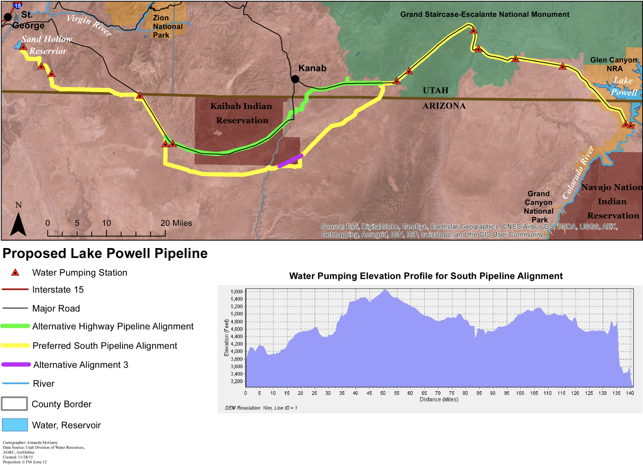
This $2+ billion project would pump 28 billion gallons of water 2,000 feet uphill across 140 miles of desert to provide just 160,000 residents in Southwest Utah with more water. Graphic credit: Utah Rivers Council
The proposed pipeline is still undergoing a one-year review process overseen by the U.S. Bureau of Reclamation, which has said that Kane County’s exit has not affected the timeline for the draft environmental impact statement it expects to release this summer…
The revised design has removed a 10-mile spur that would have carried water from the pipeline northward to Johnson Canyon in Kane County. However, a “T-joint” will likely be included where the junction would have been built, giving the county the option to tap into the resource at a later date…
Kane County’s departure marks the second time a Southwest Utah county has walked away from the project.
Iron County officials backed out in 2012, citing concerns over raised impact fees, taxes and rates.
But Washington County’s need for the water has never been clearer, said Zach Renstrom, the executive director of the Washington County Water Conservancy District.
“The same process that came back and said that Kane County won’t need this project in the foreseeable future is actually confirming that Washington County does need the water,” he said.
Washington County’s population is projected to triple to over 500,000 people by 2065, according to demographic research from the Kem C. Gardner Policy Institute.
The county was already slated to receive 95% of the water carried by the pipeline prior to Kane County’s withdrawal, Renstrom added.
Protesters seeking relief from lockdown restrictions, like these in Missouri, are being marshaled and egged on by conservative political operatives. AP Photo/Jeff Roberson
There has been passionate – and honest – argument about how many people are likely to get sick and die under different circumstances and sets of official rules. It’s not clear how uncertain and evolving scientific findings should affect extraordinary government measures that restrict citizens’ basic freedoms.
CNBC’s Rick Santelli questions a part of the 2009 federal bailout plan.
Seeking authentic feelings
Dissent – and the freedom to do it – is a crucial element of democracy. Political leaders are rightly influenced by public opinion. But it’s important to know when protests are sparked by special-interest groups seeking to manipulate officials’ perception of public sentiment.
As a journalist who has covered politics for 20 years and now studies how people process uncertainty, I note that the questions about the current protests raise echoes of the Tea Party movement a decade ago.
In February 2009, the Obama administration was grappling with a severe economic crisis caused by a collapse in the mortgage market. A reporter on CNBC, Rick Santelli, began to complain that one part of the federal bailout plan, the Homeowner Affordability and Stability Plan, might let people out of their mortgage obligations even if they should have anticipated they wouldn’t be able to afford them and would face foreclosure.
Santelli made this point on TV while standing on the floor of the Chicago Mercantile Exchange, surrounded by very wealthy traders who egged him on. It was compelling entertainment, and the speech spread rapidly through conservative media. Radio host Rush Limbaugh replayed it on his show; conservative strategists admired it, and millions of conservatives heard it.
Santelli called for a modern-day “tea party” to object to unfair government rules.
Within months, a coalition of anti-immigration reform activists, fiscal hawks, regulation opponents and social conservatives pulled together behind a common set of grievances: Barack Obama’s alleged profligate spending, his willingness to let certain groups get ahead in the economy over other groups – policies that many of them viewed as putting racial minorities at a perceived advantage to white people.
Calling themselves the Tea Party movement, most members were Republicans – but the Republican Party wasn’t speaking for them, so the nation’s two-party structure itself became a common enemy, too. When the Tea Party held its first protests, thousands of people showed up. As the protests spread, motivated partisans who look for opportunities to change attitudes and behaviors, backed by a conservative political funding machine, developed a way to capture the protest energy and channel it effectively.
Authentic protest – like how the Tea Party movement began – is a longstanding American tradition. AP Photo/Matt Rourke
Enduring sentiments, new moments
Social scientists who study new movements in politics find that the underlying sentiments are as old as civilization itself: Who gets the stuff that the government gives out? What’s fair? Who’s jumped the line?
The movement needs a common enemy – in that case, Obama, his policies and a political structure that permitted them – and the potential for real change, not just politically but socially as well. For those joining the Tea Party, the goal became clear: They could take over the Republican Party.
Fairly quickly, the Tea Party was co-opted by wealthier interests hoping to channel its energy toward slightly different ends – although much of the movement resisted the corporate takeover of its message. Public opinion surveys backed up the intuition that the movement had force.
A North Carolina protest was ostensibly coordinated by ReopenNC, whose website was registered by a Florida resident and focuses on selling T-shirts and stickers. AP Photo/Gerry Broome
A viral ideology
In mid-April 2020, it appeared, a new movement was rising to express frustration with the restrictions and uncertain endpoint to the pandemic, and the economic toll the lockdown has caused.
In the space of several days, there were protests in a dozen states, ranging from a crowd of more than 2,000 who gathered in Olympia, Washington, to several dozen in Annapolis, Maryland.
The available evidence suggests that the demonstrations were organized by paid political operatives using Facebook and new websites to encourage conservatives to protest in specific places against specific governors who had imposed strong public health restrictions on economic activity. This context indicates that one real intention of the protests was to create the illusion of an organic movement that had arisen to object to the restrictions. Evidence is to the contrary: Polling shows that just 12% of Americans think their local restrictions have gone too far – and 26% think they don’t go far enough.
He found that many of these websites, whose registration records you can see yourself at Whois.com, were owned by anti-gun-control groups that are run by the same family of brothers that organized the demonstrations through Facebook groups they run.
Several others of the “reopen” websites were registered with addresses or phone numbers used by longstanding conservative enterprises like Freedom Works. A surprising number belonged to an activist who told Mother Jones that he registered the domains to keep conservatives from using them to counter the recommendation of public health officials.
But that creates a sense that these protests grew quickly, spontaneously, and organically. The fact that protests happened in different places at different times doesn’t actually mean they’re spreading. When organized by the same small group of political operatives, sequential protests reflect the creators’ skill at mobilizing people – not a naturally rising level of frustration that ultimately pushes people to act.
Many political movements use these tactics. The problem comes from how the media presents the resulting events. On April 21, a labor union organized a protest by nurses at the White House – and media reports noted the event was created by a particular group with a specific purpose. That’s different from how the media treated the “reopen” gatherings.
The number of coronavirus infections and deaths continues to rise at an alarming rate, reminding us that this crisis is far from over. In response, the global scientific community has thrown itself at the problem and research is unfolding at an unprecedented rate.
At the same time, the pandemic has been accompanied by an infodemic of nonsense, disinformation, half-truths and conspiracy theories that have spread virally through social networks. This damages society in a variety of ways. For example, the myth that COVID-19 is less dangerous than the seasonal flu was deployed by US president Donald Trump as justification for delaying mitigation policies.
The recent downgrading of COVID-19 death projections, which reveal the success of social-distancing policies, has been falsely used to justify premature relaxing of social distancing measures. This is the logical equivalent of throwing away your umbrella in a rainstorm because it’s kept you dry until then.
This article is part of the Expert guide to conspiracy theories, a series by The Conversation’s The Anthill podcast. Listen here, on Apple Podcasts or Spotify, or search for The Anthill wherever you get your podcasts.
The new conspiracy theory that blames COVID-19 on the 5G broadband system is one of the most bizarre pieces of misinformation. There are several strains of this theory, ranging from the claims that 5G alters people’s immune systems to the idea that 5G changes people’s DNA, making them more susceptible to infection. Then there’s the idea that secret messages about 5G and coronavirus were hidden in the design of the new £20 note in the UK. In reality, 5G relates to viruses and bank notes as much as the tooth fairy relates to zoology – not at all.
The conspiracy theory has begun to penetrate mainstream society. Among other celebrities, UK TV personality Eamonn Holmes and US actor Woody Harrelson have given fuel to the idea.
Inoculating against conspiracy theories
As we document in our recent Conspiracy Theory Handbook, there is a great deal of scientific research into why people might be susceptible to conspiracy theories. When people suffer loss of control or feel threatened, it makes them more vulnerable to believing conspiracies. Unfortunately, this means that pandemics have always been breeding grounds for conspiracy theories, from antisemitic hysteria during the Black Death to today’s 5G craze.
An effective strategy for preventing conspiracy theories from spreading through social networks is, appropriately enough, inoculation. As we document in the Conspiracy Theory Handbook, if we inoculate the public by pre-emptively warning them of misleading misinformation, they develop resilience and are less likely to be negatively influenced. Inoculating messages can take several forms. As well as giving people the right facts, inoculation can also be logic-based and source-based.
Questioning the sources
The source-based approach focuses on analysing the people who push the conspiracy theory and the cultural infrastructure from which they emerged.
For example, the 5G theory began with Thomas Cowan, a physician whose medical licence is on a five-year probation. He is currently prohibited from providing cancer treatment to patients and supervising physician assistants and advanced practice nurses. So we can question his credentials.
His 5G video was from a talk he presented at a pseudo-scientific conference featuring a who’s who of science deniers. One of the headliners was Andrew Wakefield, a debarred former physician and seminal figure in the anti-vaccination movement who promotes highly damaging misinformation about vaccination based on data that he is known to have falsified.
For the public to be protected against the 5G conspiracy theory, it is important to understand its emergence from the same infrastructure that also supports AIDS denial, anti-vaccination conspiracies and climate denial.
It is therefore unsurprising that the rhetorical techniques that are deployed against the seriousness of climate change are similar to those used to mismanage the COVID-19 crisis.
Another way to neutralise conspiracy theories is through logic-based inoculation. This involves explaining the rhetorical techniques and tell-tale traits to be found in misinformation, so that people can flag it before it has a chance to mislead them. In the Conspiracy Theory Handbook, we document seven traits of conspiratorial thinking. Spotting these can help people identify a baseless theory.
One trait that is particularly salient in the 5G conspiracy theory is re-interpreting randomness. With this thought pattern, random events are re-interpreted as being causally connected and woven into a broader, interconnected pattern.
Of course, 5G has nothing to do with a virus. In the US, T-Mobile’s low-band 5G data is transmitted using old UHF TV channels. UHF TV did not cause coronavirus and neither does 5G.
Social media platforms contribute to the problem of misinformation by providing the means for it to quickly and freely disseminate to the general public. Given that 330,000 lives were lost in relation to AIDS in South Africa during the presidency of Thabo Mbeki, when denying the disease’s link to HIV was official state policy. Given that people in the UK are now vandalizing potentially life-saving communication infrastructure, social media companies should not aid and abet the life-threatening disinformation that is spewed by a nexus of science deniers and conspiracy theorists.
To their credit, these firms are making an effort to be part of the solution to the problem of misinformation. For example, YouTube has announced that it will take down any video that espouses the 5G conspiracy theory. This is a move in the right direction.
There is considerable room for improvement, however. A recent test by the non-profit Disinfo.eu laboratory found much conspiratorial content on various social media platforms, and we were able to find hundreds of YouTube videos promulgating the 5G nonsense with a few keystrokes.
Water watchers expect the runoff to be 75% of average, but if a few more storms blow through in what is left of April or even into May, that will help boost that projection…
The Weber-Ogden Basin drainage is sitting at 102% of average, which Flint said is good.
“We project we will fill all seven major reservoirs up here,” [Tage Flint said] including workhorses like East Canyon and Willard Bay.
Flint said the district is beginning to route water throughout the reservoir system for flood control purposes in case there is a major turn in the weather and it heats up quickly, bringing the snow off in a rapid fashion…
Other basins around the state are in relatively good shape when it comes to snowpack, with Bear River at 125% of normal and Price-San Rafael — which can struggle — measuring at 123% of normal, according to statistics compiled by the U.S. Department of Agriculture’s Snow Survey.
Gene Shawcroft, general manager of the Central Utah Water Conservancy District, said Deer Creek and Jordanelle Reservoir will fill, but Strawberry is significantly below average.
Westwide SNOTEL basin-filled map April 25, 2020 via the NRCS.
The Colorado Supreme Court on Monday upheld an agreement that would allow a water conservation subdistrict in Southern Colorado to import water to the Rio Grande and use the entirety of its own imported water under long-standing legal doctrine.
The Closed Basin is a watershed in the San Luis Valley with a physical separation between itself and the Rio Grande. Surface water, therefore, does not flow into the river, and is imported through canals. However, a study revealed that pumping from an underground aquifer in the Closed Basin was causing depletion to the waters of the Rio Grande.
In 2010, a water court judge approved a plan for the Special Improvement District No. 1 of the Rio Grande Water Conservation District that proposed a way to restore river flows otherwise lost to irrigation-related pumping. The subdistrict would have to replace the river depletions, and consequently it contracted with Santa Maria Reservoir Company to lease water from its supply in two reservoirs.
The company, however, had to amend its bylaws to allow for the water to go toward replacement of flows, not just for irrigation. The idea was to release water from a reservoir and have it flow down the Rio Grande, with no diversions for irrigation to the Closed Basin.
By April 2016, all affected parties had withdrawn objections except for one rancher, Jim Warner. He owned property in the Closed Basin and needed the subsurface water created as a byproduct of the importation to stay at a certain level. Warner opposed the change out of a suspicion that he could no longer use flood irrigation of his hay crops.
During the trial, SMRC argued that its importation scheme would not harm other water users in the Closed Basin. Warner did not provide any evidence to support his claim, as well as for his allegation that the Closed Basin and the Rio Grande were not separate water systems after all.
The water court found acceptable the arrangement for SMRC to replenish the Rio Grande and for the subdistrict to use the entirety of its imported water into the Closed Basin for its own irrigation purposes…
Writing for the Supreme Court, Justice Carlos A. Samour Jr. found that the water court was correct to approve the Closed Basin arrangement based on cases as early as 1907.
“We have repeatedly said that when water is introduced into a stream system from an unconnected stream system, it is imported,” he wrote. There was plainly a divide between the Closed Basin and the river, and the SMRC’s actions would not cause Warner injury.
This map shows the snowpack depth of the Maroon Bells in spring 2019. The map was created with information from NASA’s Airborne Snow Observatory, which will help water managers make more accurate streamflow predictions. Jeffrey Deems/ASO, National Snow and Ice Data Center
In the next 16-45 years, two-thirds of Western states may have to turn away from snowpack and find new tools to predict drought.
And by the late century, scientists estimate that area will grow to four-fifths of the western United States, according to a new paper in Nature Climate Change.
Ben Livneh. Photo credit: The University of Colorado
“When the temperature warms, the phase of the precipitation is likely to change from snow to rain. So less snowpack is something that’s pretty likely,” said lead author Ben Livneh, an assistant professor of civil, environmental and architectural engineering at the University of Colorado Boulder.
Water managers typically rely on artificial dates like April 1 when the snowpack is highest to predict drought. But in the coming decades, they’ll have to develop other tools like soil moisture and perhaps even satellite data to make the call.
To come up with his conclusions, Livneh analyzed the output of 28 climate models using statistical tools.
The one bright spot for Colorado is that locations above 10,000 feet of elevation will see snowpack well throughout the 21st century. Compare that to the Pacific Northwest, where water managers there could start seeing significant snowpack decline in the next 15-20 years.
Livneh said he’s hopeful that scientists will expand existing tools for water managers, and develop new ones.
Collins Ranch. Photo credit: San County Foundation
Here’s the release from the Sand County Foundation:
The Collins Ranch of Kit Carson have been selected as the recipient of the 2020 Colorado Leopold Conservation Award®.
The Collins Ranch is owned and operated by the Toby and Amy Johnson family of Cheyenne County. The conservation practices that the Johnsons have implemented on their cattle ranch have improved the wildlife habitat, water quality and grass and soil health.
The award, given in honor of renowned conservationist Aldo Leopold, recognizes ranchers, farmers, and foresters who inspire others with their conservation efforts on private, working lands.
The Johnsons will be presented with the $10,000 award on Thursday, July 30 at the Colorado Cattlemen’s Association’s 2020 Annual Convention held at the Colorado Springs Marriott in Colorado Springs.
In Colorado the award is presented annually by Sand County Foundation, Colorado Cattlemen’s Association, Colorado Cattlemen’s Agricultural Land Trust, Tri-State Generation and Transmission Association, and USDA Natural Resources Conservation Service.
“The 2020 Leopold Conservation Award nominees and applicants showcase the diversity of agriculture in Colorado and the dedication farming and ranching families have to the lands they steward, their communities, and their families,” said Erik Glenn, Colorado Cattlemen’s Agricultural Land Trust Executive Director. “These applicants featured an impressive array of families and operations from around the state. CCALT is proud of this year’s recipient the Collins Ranch and the entire Johnson family.”
“Agriculture producers positively benefit the environment, our communities, and our economy while feeding a growing society through sustainable production practices that produce more by using less. This approach is the very backbone of stewardship that the Leopold Conservation Award honors,” said Steve Wooten, Colorado Cattlemen’s Association President. “CCA warmly extends its congratulations to the Collins Ranch and the Johnson family on their well-deserved recognition, and for being leaders in Colorado’s conservation and ranching industry.”
“The Collins Ranch demonstrates what’s possible through sound conservation efforts like rotational grazing and improved water distribution systems,” said Clint Evans, NRCS State Conservationist in Colorado. “The NRCS appreciates the Johnson family for their dedication to conservation and their accomplishments as land stewards.”
“Recipients of this award are real life examples of conservation-minded agriculture,” said Kevin McAleese, Sand County Foundation President and Chief Executive Officer. “These hard-working families are essential to our environment, food system and rural economy.”
Among the many outstanding landowners nominated for the award were finalists: LK Ranch of Meeker in Rio Blanco County, and May Ranch of Lamar in Prowers County.
The Leopold Conservation Award in Colorado is made possible thanks to the generous contributions from Colorado Cattlemen’s Association, Colorado Cattlemen’s Agricultural Land Trust, Tri-State Generation and Transmission Association, USDA Natural Resources Conservation Service, Sand County Foundation, Gates Family Foundation, Stanko Ranch, American AgCredit, The Bird Conservancy of the Rockies, The Nature Conservancy in Colorado, and McDonald’s.
Sand County Foundation presents the Leopold Conservation Award to private landowners in 21 states for extraordinary achievement in voluntary conservation.
Resiliency has defined Collins Ranch for more than a century. Under the same family’s management, the ranch has weathered the Dust Bowl, crippling droughts, volatile commodity prices and sizeable prairie fires.
Today, the ranch’s fragile grassland environment benefits from continued stewardship provided by Toby and Amy Johnson and their children: Brad, Haley, and Tess.
The Johnson’s cow-calf ranch on Colorado’s Eastern Plains consists mostly of shortgrass and sandsage prairie. The family believes they are grass farmers first and cattle ranchers second. They take pride in how well their grass grows in a semi-arid region.
They know overgrazing during a drought, or overstocking their herd when beef prices are high, could have devastating consequences for this brittle rangeland.
Transitioning to a rotational grazing system from grazing an area all season long has improved their soil’s health. Now each pasture is grazed for less than a week before the land gets a minimum of 100 days rest. Utilizing more, but smaller, pastures protects against overgrazing, allows for rapid range improvement, and achieves optimal nutrition for cattle.
By moving cattle to fields of corn stalks and wheat during the winter, native grasses and riparian areas have been protected. Likewise, switching the herd’s calving season from late winter to May also proved beneficial to the health of cattle and grass.
The USDA Natural Resources Conservation Service assisted Collins Ranch with 35 miles of underground pipelines to widely distribute water for livestock and wildlife. More than 50 water sources have been replaced or installed, with bird ramps placed in all water tanks. All water sources are located uphill to prevent erosion in meadows and riparian areas along creeks.
Tamarisk leaf beetles at work
Among their other innovative conservation practices, the Johnsons released tens of thousands of beetles as a cost-effective and environmentally-friendly way to eradicate invasive and water-intensive tamarisk trees from riparian areas. They also work with Colorado Parks & Wildlife and a hunting outfitter to sustain the strong population of deer on their ranch, and they defer grazing and mark barbed wire fences to protect lesser prairie-chicken leks.
Tucked away on Colorado’s Eastern Plains, Kit Carson (population 234) is what some would call flyover country. That compels the Johnsons to focus not only on the health of their ranch, but on the health of the community.
Amy is the chairperson of Kit Carson Rural Development, a nonprofit that works to fill the gaps that exist in a community without a department of public health, public housing, hospital, day care and recreational center. Since 2006 the group has built the town’s only park and a business incubator, cleaned up a massive brownfield site, and created affordable housing for teachers and local families, by leveraged more than $2.7 million in grants and contributions. Likewise, Toby serves on the local school board, which successfully sought a grant to build a new school.
The Johnsons are doing more than their part to keep this small town thriving so future generations will continue ranching and caring for Colorado’s landscape.
Open-minded, common sense individuals matched with hands-on technology are making a difference in the drive to conserve water in the Ogallala Aquifer.
Those individuals are thriving at Northwest Kansas Technical College, Goodland, Kansas, an institution that has a history of regularly raising bumper crops of entrepreneurs. The latest addition is irrigation management. In 2016, NWKTC’s Precision Ag program launched its Water Technology Farms project to promote the adoption of various irrigation management technologies to help producers in that region, said Weston McCary, director of Precision Agriculture and UAS Technologies at the college.
Students welcome the opportunity to learn how to use new techniques to preserve groundwater, McCary said, adding that is essential for agriculture and agricultural-related businesses in the High Plains…
Stevens GroPoint Profiling Probe via Agri Tech Tomorrow.
“The biggest thing to me is the moisture probes,” [John Gower] said. “There’s data to show that if you do have a moisture probe, if used to its full potential and you trust it, you will save money on pumping costs and cut down on the water usage,” said Gower, whose major is in precision agriculture with an associate’s degree in applied science. “They can now grow as much corn with less water usage. It is hard to argue against success.”
Variable rate irrigation scripts also help producers to address topography and to keep water from running down ditches, he said.
Matching those VRI scripts with a soil probe in a well-maintained pivot system can help producers to be more efficient and preserve precious groundwater, he said. Gower is also working with McClain on a precision planter and the soon-to-be graduate wants to be able to follow a passion of improving planting equipment for producers and also farming.
The Ogallala aquifer, also referred to as the High Plains aquifer. Source: National Oceanic and Atmospheric Adminstration
Photo credit from report “A Preliminary Evaluation of Seasonal Water Levels Necessary to Sustain Mount Emmons Fen: Grand Mesa, Uncompahgre and Gunnison National Forests,” David J. Cooper, Ph.D, December 2003.
Attorney General Phil Weiser released the following statement regarding the final Waters of the United States rule that the U.S. Environmental Protection Agency and Army Corps of Engineers released today:
“The federal government’s final Waters of the United States rule is too limited and excludes a significant percentage of Colorado’s waters from Clean Water Act protections. The final rule threatens to create unacceptable impacts to the state’s ability to protect our precious state water resources, and, in the absence of extraordinary state efforts to fill the gaps left by the federal government, will harm Colorado’s economy and water quality.
“We are pleased the final rule protects important agriculture exemptions and provides continued assurance that states retain authority and primary responsibility over land and water resources that are important to Colorado. However, the federal government’s decision to remove from federal oversight ephemeral waters, certain intermittent streams, and many wetlands is based on flawed legal reasoning and lacks a scientific basis.
“We are going to take legal action to protect Colorado waters and prevent the harmful aspects of the final rule from taking effect here.”
Fen soils are made of a rich, organic peat material that take thousands of years to form and require a constant groundwater source to survive. At the Rocky Mountain Fen Research Project, scientists transplanted fen soils from another site to the “receiver” site south of Leadville where they restored a groundwater spring to sustain the transplanted soils. Photo credit: Sarah Tory/Aspen Journalism
FromThe Grand Junction Daily Sentinel (Dennis Webb):
The Environmental Protection Agency and Army Corps of Engineers published the new rule Tuesday in the Federal Register, after announcing its components in January. It takes effect June 22.
Much of the ongoing dispute surrounds how “waters of the United States” are defined in implementing the Clean Water Act.
The Trump administration says its new rule applies to territorial seas and traditional navigable waters, perennial and intermittent tributaries to those waters, wetlands adjacent to waters falling under the rule’s jurisdiction, and some lakes, ponds and impoundments. Groundwater, ephemeral streams that flow only due to rainfall, many ditches and prior converted cropland are among waters exempted from the rule.
Weiser and the administration of fellow Democrat Gov. Jared Polis don’t totally oppose the new rule, praising its agricultural exemptions and saying it recognizes state authority…
The Colorado Department of Public Health and Environment says the rule eliminates many federal protections and almost 70% of Colorado waters could be impacted by the rule.
Stewart Udall stands at Rainbow bridge, one of the world’s largest known natural bridges, in Utah. Courtesy of the Udall family
Here’s an in-depth remembrance of Stewart Udall from John De Graaf writing in Sierra Club Magazine. Click through and read the whole article. Here’s an excerpt:
The 1960s interior secretary was a man ahead of his time. Now it’s time to remember him.
There’s another political figure who, in the halls of government at least, was the leading prophet of environmental protection and sustainability: Interior Secretary Stewart Udall. Beyond the environmental history books and the memories of political junkies, Udall is too little known or recognized. And that’s a shame, because his accomplishments were unmatched, and deserve to still be celebrated today. As President Barack Obama said when Udall passed away in 2010, “Stewart Udall left an indelible mark on this nation and inspired countless Americans who will continue his fight for clean air, clean water, and to maintain our many natural treasures.”
UDALL’S LEGACY
Stewart Lee Udall served as secretary of the interior under both John F. Kennedy and Lyndon Johnson. During that time, he provided the political leadership for a legacy that includes the original Clean Air and Water Acts, the Land and Water Conservation Fund, the Wilderness Act, the Endangered Species Act, the Highway Beautification Act, the Wild and Scenic Rivers and National Scenic Trails Acts, the Pesticide Reduction and Mining Reclamation Acts, the Solid Waste Disposal Act, the creation of a host of national parks and monuments, and large-scale funding for public transportation. Of course, in this he worked with activists like the Sierra Club’s first executive director, David Brower—who convinced Udall that the power dams the Bureau of Reclamation had proposed for the Grand Canyon would be tragically destructive. Udall also collaborated with political figures across the spectrum, especially Pennsylvania Republican congressman John P. Saylor. Most of his victories would have been impossible without his ability to win bipartisan support; today, many of them are being undone by the Trump administration.
But Udall was more than an environmentalist. With his brother, Mo, he challenged Jim Crow policies at the University of Arizona while both were students and basketball stars there in the 1940s. With support from President Kennedy, he forced the integration of the Washington Redskins football team in 1962. He spoke out for peace and against the Cold War, traveling that same year with poet Robert Frost to the Soviet Union to meet Khrushchev. He fought for compensation for the victims of atomic testing and uranium mining, reshaped the Bureau of Indian Affairs to respect tribal rights, and warned early on of the dangers of global warming. Several of his children continue his activism. His son, Tom, represents New Mexico in the United States Senate.
Udall was a prolific writer and speaker, authoring dozens of articles and nine books, including his noted environmental wake-up call, The Quiet Crisis. An advocate of the arts and humanities, he championed national endowments for both during the 1960s. He was an unabashed liberal who believed deeply in a robust government and the power of public policy to address the nation’s problems and promote a better quality of life for its people…
More than ever, as the current administration rolls back our environmental legacy and turns a blind eye to a warming planet, we need leadership and examples like Stewart Udall’s. He understood the issues of environment, peace, and justice as interconnected in “a single web,” and sensed that a love for art and beauty could inspire us to take better care of the planet.
Stewart Lee Udall died on March 20, 2010, at the age of 90. His memory must not.
Grand Canyon from Grandview Point January 24, 2009 via the National Park Service
Homeowners can help sprinkler techs firing up systems amid COVID-19. The post Social distancing matters — even with your sprinkler system appeared first on News on TAP.
Denver Water employees use 3D printers and sewing skills during crisis to protect front-line workers. The post Making masks to keep co-workers safe during COVID-19 appeared first on News on TAP.
Click here to read the report. Here’s the Executive Summary:
In 2018, Colorado released its first electric vehicle (EV) plan,1 setting forth goals, actions and strategies to develop EV fast-charging corridors across the state and establishing a target of 940,000 EVs by 2030. The state has seen significant achievements in the two years since the plan’s release, including:
Award of a contract to ChargePoint for the build-out of EV fast-charging stations at 33 sites along Colorado’s major transportation corridors;
State investment to install 351 EV chargers across Colorado;
Adoption of a zero emission vehicle (ZEV) standard in August 2019 with the support of the auto manufacturing industry;
Dedication of all remaining state Volkswagen diesel settlement funds to ZEV charging infrastructure and zero emission buses, shuttles and trucks including first round grant awards totaling $13.9 million to six transit agencies for 23 battery electric buses and supporting infrastructure— with a second round of awards to be announced in spring 2020; and
More than doubling the number of EVs registered in Colorado from 11,238 in August 2017 to over 24,000 in June 2019.
Despite these achievements, more needs to be done. Environmental impacts from the transportation sector— and the resulting health and economic consequences— are a major concern. Greenhouse gas emissions from vehicles will soon be the top source of emissions in Colorado and a significant portion of the state is classified as an ozone non-attainment area by the US Environmental Protection Agency. Transportation is one of the two largest sources of ozone precursors along with oil and gas production, and reducing transportation emissions is a critical strategy to meet federal health-based air quality standards.
The vision for the Colorado Electric Vehicle Plan 2020 is: Large-scale transition of Colorado’s transportation system to zero emission vehicles, with a long-term goal of 100% of light-duty vehicles being electric and 100% of medium- and heavy-duty vehicles being zero emission.
This will be accomplished by taking actions to meet five goals:
Increasing the number of light-duty EVs to 940,000 by 2030;
Developing plans for transitioning medium-duty (MDV), heavy-duty (HDV) and transit vehicles to ZEVs;
Developing an EV infrastructure goal by undertaking a gap analysis to identify the type and number of charging stations needed across the state to meet 2030 light-duty vehicle (LDV), MDV and HDV goals;
This winter brought near-average snowpack to the mountains in Colorado that feed the rivers and reservoirs in San Juan County, but the Bureau of Reclamation is still anticipating below average runoff.
That means there will not be a spring peak release from Navajo Dam this year.
The Bureau of Reclamation canceled its Navajo Dam operations meeting, scheduled for this week, due to the coronavirus. Instead, Susan Behery, a hydraulic engineer with the BOR’s Western Colorado Area office in Durango, sent out an email with the information that would have been presented during the meeting.
According to the power point presentation that would have been given during the meeting, dry soil conditions will reduce the runoff as the snow melts.
The snow-water equivalent in the San Juan Basin is at 84% of normal. Meanwhile, the Animas Basin’s snow-water equivalent is at 94% of normal and the Dolores Basin has 91% of its normal snow-water equivalent, according to the presentation.
Drought conditions in the Four Corners area will likely persist, according to the U.S. Seasonal Drought Outlook released April 16 by the National Oceanic and Atmospheric Administration.
The BOR anticipates Navajo Reservoir will peak between 6,060 and 6,065 feet this year and it is not planning any high releases for this spring. That means the releases from the dam will remain at or near the current levels.
After the runoff season ends, these releases could increase to meet the needs of farmers and ranchers and to maintain the target baseflow for endangered fish in portions of the San Juan River deemed critical habitat. Those releases could vary from 500 to 1,000 cubic feet per second.
The findings pinpointed basins around the world most at risk of not having enough water available at the right times for irrigation because of changes in snowmelt patterns. Two of those high-risk areas are the San Joaquin and Colorado river basins in the western United States. Photo: Kevin Bidwell/ Pexels
From The National Science Foundation (NSF Public Affairs):
April 23, 2020
Farmers in parts of the western United States who rely on snowmelt to help irrigate their crops will be among the hardest hit in the world by climate change, a new study reveals.
In a paper published in Nature Climate Change, researchers funded by the National Science Foundation analyzed monthly demand for irrigation water along with snowmelt runoff across global basins from 1985 to 2015. The goal was to determine where irrigated agriculture has depended on snowmelt runoff in the past, and how that might change with a warming climate.
The researchers then projected the changes in snowmelt and rainfall runoff if Earth warms by 2 to 4 degrees Celsius (about 3.5 to 7 degrees Fahrenheit).
The findings pinpointed basins most at risk of having water at the right times for irrigation because of changes in snowmelt patterns. Two of those high-risk areas are the San Joaquin and Colorado river basins in the western United States.
“In many areas of the world, agriculture depends on snowmelt runoff happening at certain times and at certain magnitudes,” said Yue Qin, a geographer at The Ohio State University. “But climate change is going to cause less snow and early melting in some basins, which could have profound effects on food production.”
Qin, lead author of the study, designed the research with Nathaniel Mueller of Colorado State University and Steven Davis of the University of California, Irvine.
If Earth warms by 4 degrees, the researchers project decreases in the share of irrigation water demand met by snowmelt of 33 percent to 18 percent in the San Joaquin Basin and 38 percent to 23 percent in the Colorado Basin.
Other basins in which agriculture is at particular risk because of changes in snowmelt are in Southern Europe, western China and Central Asia.
“This study shows the importance of water resources from snowmelt on agricultural practices, and the potential impact of climate change on this precious resource,” says Ingrid Padilla, a program director in NSF’s Division of Earth Sciences.
The secrets of water revealed: UD’s computer simulation of water molecules is based exclusively on quantum physics laws. Figure by Omololu Akin-Ojo and David Barczak via The University of Delaware. http://www1.udel.edu/PR/UDaily/2007/mar/water030207.html
There are, and will continue to be, no shortage of lessons from the COVID-19 pandemic. What sticks and transforms society, business and the public sector is up to us.
We can focus on attempting to return to what we believed was “normal” or we can learn to rebuild and redesign society and businesses in a more equitable, sustainable and resilient manner.
One lesson from our current social and business reality is that digital technology solutions have become an even more critical aspect of our lives. Let me expand on what this means for water and why I am doubling down on digital water technologies to ensure access to water, sanitation and hygiene.
More than ever it is clear that access to water is critical for society, businesses and ecosystems.
No water, no anything. And now digital technology solutions are an ever-increasing tool in ensuring access to water for a range of uses — such as drinking water, hand washing, agriculture and manufacturing.
Late last year, I authored “2019, the year analog water solutions died.” When this was published, the digital transformation of water was well underway, and I believed that analog solutions were no longer adequate to address water scarcity and quality. This article was followed recently by “Digital Tools Must Help us Address Water Scarcity” during the early days of the pandemic. In the last few weeks, we have seen the importance of digital tools dramatically increase, and now they are a critical component of the water sector.
The most obvious need for digital water tech is in the water and wastewater utility sector as water professionals, in many cities and regions, are “sheltering in place” at their utilities.
The importance of the ongoing operation of these utilities can’t be overstated, and the pandemic has strained their workforce.
A recent American Water Works Association survey asked, “What challenges to sustaining business operations is your organization anticipating due to COVID-19?” Of the utilities that responded, 75 percent indicated that “Absenteeism and the Continuity of Operations” was their No. 1 challenge, with impacts on field operations being No. 2 at 46 percent. It has become clear that the water utility workforce needs digital tools such as smart water meters and artificial intelligence to support it not just during these times but also going forward.
The pandemic is a reminder of the critical role that drinking water and wastewater systems play in protecting public health and safety and supporting the social and economic well-being of all communities.
These digital solutions can provide remote monitoring and control of processes and critical infrastructure, ensuring continuity in service when staff are working remotely. Additionally, when absenteeism occurs, digital technologies can augment decreased and strained resources and mitigate the risks of service interruptions.
These technologies also have been used during times when utilities have had challenges with recruitment. Using data analytics and implementing digital water strategies delivers direct operational and environmental benefits to a utility operation, both during a crisis and during its resilient recovery.
The digital transformation of the water sector is driving new business and investment opportunities. For example, Bluefield Research reported in January that “digital water in the U.S. and Canada is forecasted to grow 6.5 percent annually, far outpacing the growth of the broader municipal water and wastewater sector over the next decade.” This is an encouraging sign that more and more, utilities are recognizing the potential for digital technologies to transform their operations and mitigate the risk of failure during a crisis event.
Digital solutions to support our utility workforces are the only option. We need to ensure these technologies are deployed by adequately funding our water infrastructure. Neglect of our critical water infrastructure in the U.S. is also no longer an option.
FromThe High Country News [April 23, 2020] (Jonathan Thompson):
COVID-19 reverberates across the energy world.
Graphic credit: The High Country News
In mid-January, when the epidemic was still mostly confined to China, officials there put huge cities on lockdown in order to stem the spread. Hundreds of flights into and out of the nation were canceled, and urban streets stood empty of cars. China’s burgeoning thirst for oil diminished, sending global crude prices into a downward spiral.
And when oil prices fall, it hurts states like New Mexico, which relies on oil and gas royalties and taxes for more than one-third of its general fund. “An unexpected drop in oil prices would send the state’s energy revenues into a tailspin,” New Mexico’s Legislative Finance Committee warned last August. Even the committee’s worst-case scenario, however, didn’t look this bad.
Now, with COVID-19 spanning the globe, every sector of the economy is feeling the pain — with the exception, perhaps, of toilet paper manufacturers and bean farmers. But energy-dependent states and communities will be among the hardest hit.
Graphic via The High Country News
At the end of December, the U.S. benchmark price for a barrel of oil was $62. By mid-March, as folks worldwide stopped flying and driving, it had dipped to around $20, before falling into negative territory, and then leveling off around $10 in April. The drilling rigs — and the abundant jobs that once came with them — are disappearing; major oil companies are announcing deep cuts in drilling and capital expenditures for the rest of the year, and smaller, debt-saddled companies will be driven into the ground.
Graphic via The High Country News
COVID-19 and related shocks to the economy are reverberating through the energy world in other ways. Shelter-in-place orders and the rise in people working from home have changed the way Americans consume electricity: Demand decreased nationwide by 10% in March. As airlines ground flights, demand for jet fuel wanes. And people just aren’t driving that much, despite falling gasoline prices, now that they have orders to stay home and few places to go to, anyway.
Graphic via The High Country News
The slowdown will bring a few temporary benefits: The reduction in drilling will give landscapes and wildlife a rest and result in lower methane emissions. In Los Angeles, the ebb in traffic has already brought significantly cleaner air. And the continued decline in burning coal for electricity has reduced emissions of greenhouse gases and other pollutants.
Graphic via The High Country News
But the long-term environmental implications may not be so rosy. In the wake of recession, governments typically try to jumpstart the economy with stimulus packages to corporations, economic incentives for oil companies, and regulatory rollbacks to spur consumption and production. The low interest rates and other fiscal policies that followed the last global financial crisis helped drive the energy boom of the decade that followed. And the Trump administration has not held back in its giveaways to industry. The Environmental Protection Agency is already using the outbreak as an excuse to ease environmental regulations and enforcement, and even with all the nation’s restrictions, the Interior Department continues to issue new oil and gas leases at rock-bottom prices. [ed. emphasis mine]
Graphic via The High Country News
The impacts on energy state coffers will unfold over the coming weeks and months. But the shock to working folk from every economic sector has come swiftly. During the third week of March, more than 3 million Americans filed for unemployment — more than 10 times the claims from a year prior.
A view of the interchange of Highway 60 and Interstate 710 during the coronavirus pandemic on April 11, 2020 in Los Angeles, California. The county’s stay-at-home order has drastically decreased the traffic flow in and around Los Angeles. Photo credit: Roger Kisby/High Country News
Infographic design by Luna Anna Archey. Sources: U.S. Energy Information Administration, New Mexico Legislative Finance Committee, U.S. Bureau of Labor Statistics, California Independent System Operator, Baker-Hughes, Unacast, FlightRadar24, Wyoming Department of Revenue, Carbon Footprint, International Air Transport Association, OAG.
Click on a thumbnail graphic to view a gallery of drought data from the US Drought Monitor.
US Drought Monitor April 21. 2020.
West Drought Monitor April 21. 2020.
Colorado Drought Monitor April 21. 2020.
Click here to go to the US Drought Monitor website. Here’s an excerpt:
This Week’s Drought Summary
A very active precipitation pattern impacted areas of the South into the Southeast over the last week. As with the recent storm paths, the areas along the Gulf Coast were again in an unfavorable position in which some areas did see rains, but the dryness continued. A spring snow event tracked through the Plains and into the Midwest, bringing with it a mix of rain and snow. Temperatures were cooler than normal over almost the entire CONUS region with only the coastal regions of the West and Florida being above normal for temperatures. Departures were greatest over the Midwest, where temperatures were 12-15 degrees below normal…
High Plains
The region was also cooler than normal for the week, with departures of 8-12 degrees below normal over most of the region. The region was mostly dry for the week, with only areas of eastern Kansas and southeast Wyoming above normal. Similar to what has been observed in the Midwest, the dry conditions have been favorable for early fieldwork in the agricultural sector as well as calving. There have been many discussions about the dryness in northern Kansas and southern Nebraska, but so far, no real issues are developing. Eastern Colorado and southwest Kansas remain the hot spots for drought. New areas of abnormally dry conditions were introduced over most of western North Dakota into northwest South Dakota this week. Northeast South Dakota also had a pocket of abnormally dry conditions introduced. A new area of abnormally dry conditions was introduced in portions of northern Kansas and southern Kansas. The dry areas are being discussed extensively by the local experts, who are monitoring the situation closely…
West
Cooler than normal temperatures dominated the region, with departures of 9-12 degrees below normal over the Rocky Mountains and 3-6 degrees below normal over the Southwest and into the Great Basin. Temperatures were near normal to 3-6 degrees above normal over most of California, Oregon, and Washington. Some pockets of precipitation in the region were observed, but this was mostly a dry week over much of the area. In response to the continued dryness, a new area of extreme drought was introduced this week in northern California and southwest Oregon. These areas are experiencing widespread impacts to the agricultural sector as well as those systems not impacted by or benefiting from stored water. Drought areas expanded in and intensified over much of Oregon while abnormally dry conditions expanded over western Washington. Due to the good late-season snowpack in Idaho and western Montana, some areas of abnormally dry conditions were improved this week. Southern Idaho showed degradation this week with drought areas expanding and abnormally dry conditions spreading into southwest portions of the state. Far northeast Montana did see abnormally dry conditions spread south this week. A new area of severe drought was introduced into central Utah with an expansion of moderate drought conditions as well, while severe drought was expanded over most of southern Colorado and into northern New Mexico…
South
Much of the region was dry, especially in portions of Texas and Oklahoma and southern Louisiana. The big exception was Mississippi, central Louisiana, and into east Texas where up to 400% of normal precipitation was again recorded this week. Cooler than normal temperatures helped to offset the dryness as most areas were 6-12 degrees below normal for the week. In response to the short-term dryness, abnormally dry conditions and moderate drought were expanded over portions of the Texas and Oklahoma panhandles with a couple of new pockets of abnormally dry conditions in western Oklahoma into Texas. The abnormally dry conditions were expanded over west Texas while a reassessment of conditions in south Texas led to improvements and the removal of exceptional drought in the region. Mostly status quo was maintained along the Gulf Coast of Texas, where some improvements were made, but a new severe drought pocket popped up along the coast. Improvements were made to the abnormally dry conditions in Louisiana and Mississippi in response to the rain, and even some severe drought was improved in southern Louisiana. The coastal regions remain dry and will continue to be monitored…
Looking Ahead
Active storm pattern, with the greatest precipitation expected over the Lower Mississippi Valley, into the Ohio River Valley and into the Southeast, including Florida. Some coastal precipitation is expected over portions of Washington and into Oregon, but most of the rest of the West is not anticipating much precipitation. Temperatures during this time will be cooler than normal over the East and especially the Northeast, where departures will be in the range of 9-12 degrees below normal. The West and Southwest are anticipated to be the warmest with departures of 9-12 degrees above normal.
The 6-10 day outlooks show a higher probability of drier than normal conditions over much of the West and into the Plains and Southeast as well as Alaska. In contrast, there is a higher probability of wetter than normal conditions over the Midwest and Northeast. Temperatures during this time show that the greatest probability of warmer than normal temperatures is over the Southwest with much of the western half of the United States having a greater likelihood of warmer than normal temperatures. Much of the Midwest, the Northeast, the Mid-Atlantic and eastern Alaska have the best chances of recording below-normal temperatures, with the highest probabilities in the Northeast.
US Drought Monitor one week change map ending April 21, 2020.
Click here to read the current assessment. Click here to go to the NIDIS website hosted by the Colorado Climate Center. Here’s the summary:
Summary: April 21, 2020
Cooler temperatures dominated the Intermountain West (IMW) last week. But only the northern portions of the IMW benefited from moisture with the cooler temperatures. The northern ranges of Colorado and Utah received over half an inch of moisture. The Front Range urban corridor got a healthy shot of spring snows.
In the Four Corners, despite some colder temperatures, snowmelt has kicked into high gear. It’s melting faster and earlier than normal. And with not much precipitation in April, water supply forecasts for the late spring and summer are quickly declining.
The Four Corners, east across the San Luis Valley and Upper Rio Grande, and across the eastern plains of Colorado and New Mexico are areas of concern. A poor performing monsoon, with lack of decent moisture for winter wheat planting, a struggle to keep up with average during the winter, and a shut-off of precipitation during the spring, SPIs across many time scales are below -1.5, winds are kicking up dust and increasing fire danger, failed winter wheat crops are certain, and extra feed needs to be purchased for cattle.
For the northern watersheds of the IMW, snowpack is following a more steady timeline as new snows have accumulated. Water supplies are forecasted to be near or slightly below normal
While some precipitation moves across southern CO and northeast NM today, they are not expected to get much more moisture this week. It will do little to help conditions there. Only minor amounts of precipitation are expected over the northern part of the IMW this week. Mostly dry and warm conditions will dominate over the next couple of weeks.
The final BLM plan for managing multiple uses on federal land in the Uncompahgre Plateau unveiled earlier this month did not limit oil and gas development in the North Fork Valley.
For nearly a decade, a group of farmers in the North Fork Valley joined with local tourism businesses and conservation groups to craft a resource management plan that could help the Bureau of Land Management shepherd the multiple uses of the valley’s public lands for the next 20 years.
More than 600 mining jobs disappeared in that decade of planning as the coal industry contracted and mines closed. Entrepreneurs in the lush communities around Paonia and Hotchkiss helped diversify the local economy from reliance on a single, extractive industry to an eclectic mix of organic agritourism and outdoor recreation.
The group’s North Fork Alternative Plan proposed energy development on 25% of the valley’s public lands, with increased protections for water and recreational attractions in the region.
“We put a lot of effort into negotiating with the BLM with what we thought was a pretty constructive way to share our values and how they should consider those values in managing the lands here,” said Mark Waltermire, whose Thistle Whistle farm is among 140 members in the North Fork’s Valley Organic Growers Association.
The final BLM plan for managing multiple uses on federal land in the Uncompahgre Plateau unveiled earlier this month did not limit oil and gas development in the North Fork Valley. And it did not weigh the state’s concerns over energy projects injuring wildlife, habitat and air quality. But as the first resource management plan released under the Trump Administration, it did represent the president’s pivot toward “energy dominance” by reducing regulations and greenlighting exponentially more coal mining.
“I feel betrayed by the system,” said Waltermire this week after spending the day fixing a tractor on his Delta County farm. “Most definitely this is a step backward. Really it’s even worse. We have lived with coal for 100 years and coal has proven to be compatible with the agriculture we practice here. But gas and the oil development is a different beast. It is a much more substantial threat to our economy, with increased traffic and the potential for spills. That could destroy our reputation that we have built for our valley. It could change everything.”
[…]
Earlier this month the agency released the final plan for managing the vast swath of the Western Slope, which is an update to the region’s 1989 RMP. Many of the wildlife, habitat and environment-focused objections to the Trump Administration’s “energy dominance” push to loosen regulations around domestic energy production — including those from Gov. Jared Polis, Colorado Parks & Wildlife, county commissioners, conservation groups and local residents — were dismissed.
As Colorado’s local BLM officials honed the preferred alternative — Alternative D — for the RMP last fall, the agency’s higher-ups crafted a new alternative. Alternative E identified energy and mineral development as key planning issues, and promoted access and a reduced regulatory burden alongside economic development as top priorities.
The BLM said the RMP would contribute $2.5 billion in economic activity into the region and support 950 jobs a year for the next 20 years.
The Alternative E plan:
Increased coal available for leasing by 189%, to 371,250 acres from 144,790 acres.
Added 13,020 acres to the region’s 840,440 acres open for mineral development.
Removed more than 30,000 [acres] from development in areas previously identified for leasing.
Cut acres the BLM could sell from 9,850 to 1,930.
Added six special recreation management areas and three extensive recreation management areas, setting aside 186,920 acres for recreation management.
The final draft of the proposed RMP conflicted with new state laws protecting wildlife, recreation access and improving air quality, so Polis last year sent a letter to the BLM’s Colorado director expressing his concerns as part of a consistency review that makes sure the agency’s plan aligned with state policies.
Oil and gas leasing sites near Paonia. Courtesy of EcoFlight via The High Country News.
Specifically the state wanted the agency to limit the density of development — including oil and gas facilities — to one structure for every square mile to help protect wildlife corridors. It also asked the agency to develop a comprehensive plan to protect and conserve the Gunnison sage grouse and its habitat. Polis noted that the BLM plan allowed an increase in greenhouse gas emissions from oil and gas development that conflicted with last year’s House Bill 1261, which aims to cut those emissions by 90%. The BLM plan also conflicted with Senate Bill 181, which allows the state to consider public health and the environment when regulating oil and gas development.
The BLM’s final plan released this month did not include the state’s push for limiting the density of development or creating a region-wide wildlife and sage grouse conservation plan. But it did agree to protect 33,000 acres of riparian habitat from surface development and initiate a future statewide planning effort to study density on BLM land. The agency also agreed to coordinate with the state over potential development in sage grouse habitat.
“Our issue is that we worked on the preferred alternative, Alternative D and we sent that to Washington for approval. Alternative E was never contemplated and that’s what came back from D.C. We were not able to weigh in on that option,” said Department of Natural Resources director Dan Gibbs, who joined Polis in the only process available for commenting on the final proposal: a protest letter to the BLM over its proposed RMP.
Gibbs said he was happy the agency heard a portion of the state’s protests and the final decision included plans to work more closely with the state on a border-to-border plan for limiting development density…
The Public Employees for Environmental Responsibility group uncovered a BLM document summarizing an October 2018 meeting where the agency’s Washington D.C. leaders told Uncompahgre Field Office managers that their preferred alternative “misses the mark” and was “not in line with the administration’s direction to decrease the regulatory burden and increase access.”
[…]
Aerial view of the San Miguel River. Photo credit: The Montrose Daily Press
San Miguel County, for example, asked the BLM to expand areas of critical concerns in the San Miguel River watershed and remove those riparian areas from mineral leasing. The final plan reduced the size of those areas and kept them open for mineral leasing. Montrose County asked for some areas inside Camelback, Dry Creek and Roc Creek to be managed for wilderness protection, but the final plan did not set aside any land in the county for wilderness protection.
San Miguel County commissioner Hilary Cooper said that while the plan is slightly improved by the promise to work with Parks and Wildlife on a density-limiting plan, “it still feels like the BLM is not a willing partner in the management of our land.”
This month he blasted the plan as “completely inadequate.”
[…]
“You see what happened today?” he said this week, after the price of a barrel of oil collapsed to below $0 for the first time as a stalled nation sits at home and oil stockpiles swell.
“That is really good news. I bet they are not going to look to develop new rigs for 10 years now,” Schwartz said. “We seem to have bought ourselves some time. Gas and oil are looking to survive right now. And if they look to fracking in our valley, they know we will fight them tooth and nail every step of the way. They don’t want that.
“And really, who knows what will happen in the future,” he said. “We will have a new administration in a year or four years and this whole thing could change. Either way, we are coming out the end of this solid and safe.”
Many Americans may be surprised and confused to see farmers dumping milk down the drain or letting vegetables rot in their fields.
Why would they be destroying food at a time when grocery stores and food pantries struggle to keep pace with surging demand during the coronavirus pandemic?
As sociologists with a specialty in agriculture and food, we study how the structure of the food system affects people’s lives and the environment. Seeing food destroyed at a time when people are going hungry highlights both short- and long-term problems with this system.
Food and toilet paper have more in common than you think. Rodney Stubina/EyeEm/Getty Images
A tale of two supply chains
Surprisingly, the supply chain for food bears a striking similarity to that of another product that has experienced shortages: toilet paper.
Like the toilet paper market, the food industry has two separate supply chains for consumer and commercial use. On the consumer side are grocery and convenience stores that focus on small purchases. The commercial side represents restaurants and institutions such as schools, prisons, hospitals and corporate cafeterias that purchase large quantities of foods in bulk. Ultimately, commercial institutions purchase in sizes that exceed the storage capacity of most households and food pantries.
While the commercial and the consumer supply chains are different, there are some commonalities: Both are complex, cover long distances and rely on just-in-time production. Both are also increasingly concentrated, meaning that there are only a few companies between farmers and consumers that process and distribute raw agricultural goods into edible food. For example, on the commercial side, Sysco and U.S. Foods control an estimated 75% of the market for food distribution.
These characteristics make the supply chains more vulnerable to disruptions.
Meat plant closures has created a bottleneck for processing. AP Photo/Charlie Neibergall
Where the supply chains diverge
To understand why this food can’t readily be diverted to consumers, let’s take a closer look at the supply chains for meat, vegetables and milk. With each category, there are different reasons.
Vegetable farmers, for example, have a lot of crops growing in their fields intended for commercial buyers like schools, restaurants and cruise lines, which are no longer purchasing these products.
But a worseninglabor shortage makes it a lot harder to harvest or pick their crops and package them for consumers.
So a combination of plunging commercial demand, not enough low-wage yet skilled laborers, falling prices and a short window in which to pick vegetables means it has become cheaper to simply let them rot in the fields.
As for meat, restaurants typically order larger cuts and use more of the pricier parts like tenderloins. In contrast, much of the meat purchased on the consumer side is sold in “case-ready” packages, and ground beef is far more common.
So in general, commercial buyers tend to buy parts of the cow or pig that consumers simply don’t prepare at home. But what’s more, meat plant closures due to COVID-19 outbreaks are creating a bottleneck for slaughtering and processing animals, which also have a short window before they’re past their prime. As a result, producers, particularly pork farmers, are debating whether to feed and care for their animals past their prime or simply euthanize them.
Milk is even more complicated when it comes to how it flows along the food chain.
First, there’s no stopping cows giving milk; udders that are full must be emptied daily. The only question is where that milk will go.
Restaurants and organizations like schools purchase nearly half of all milk, butter and other dairy products processed in the U.S. Pizzerias alone take nearly a quarter of all U.S. cheese production.
With many of these customers closed or cutting their purchases, there’s lots of excess milk. Unfortunately, processors do not have the equipment to package that milk into smaller containers for grocery stories and retail use.
As for converting more milk into dairy products with longer shelf lives like cheese, there was already a glut of mozzarella and other cheese plugging up cold storage space. And despite a rise in takeout pizza, overall demand for cheese has “dropped like a rock,” according to trade industry sources.
That has left dairy farmers with little choice but to dump excess milk into manure ponds and ditches.
A quarter of all cheese makes its way to a pizza. Karl Tapales/Getty Images
A longer-term problem
Many states are working on short-term solutions to bridge the gap between the two supply chains.
Nebraska is temporarily allowing restaurants to sell unlabeled packaged foods to customers, Texas is pushing restaurants to prepare food care packages for at-risk families, and many other states have changed their health regulations to allow restaurants to repackage products into smaller quantities to sell to the public.
In addition, the U.S. Department of Agriculture plans to begin purchasing US$3 billion in fresh produce, dairy and meat to support farmers and eventually distribute it to food pantries and other organizations feeding Americans in need.
Although helpful in the short term, we believe a longer-term problem that needs to be addressed is how concentrated food supply chains have become, which has made them less nimble in adapting to disruptions like a health pandemic.
FromThe High Country News [April 22, 2020] (Gary Paul Nabhan):
Farmers and ranchers hold the key to carbon storage.
As we celebrate Earth Day’s 50th anniversary, the environmental movement finds itself at a critical point in time to reflect upon its record. When have we, as environmentalists, fostered collaboration with the food and farming sectors, and when have we pushed those potential partners away and generated conflict in our rural communities?
When I worked at the headquarters of the very first Earth Day in 1970, it operated as a network of grassroots environmental organizers, and there was little focus on the overall environmental benefits or consequences of farming and ranching.
Micha Ide of Bright Ide Acres farm, Washington, practices rotational grazing on her farm. Animals are moved frequently around the pasture to increase soil fertility and enhance the sustainability of the farm. Photo credit: Audra Mulkern
Our little newsletter, Environmental Action, covered how toxins were appearing on the lands and in our food, even though terms like “environmental justice” and “food justice” had yet to be coined. Nevertheless, very little of our “environmental action” was directed to ensuring the health of the soil, the diversity of the crops planted on it, the preservation of food-producing or the viability of livelihoods for farmers and ranchers.
Francis Moore Lappé’s Diet for a Small Planet had recently hit the stands, and all the talk was about abandoning meat to eat low on the food chain. For a while, many of us tried to boil up soybeans or pintos to plop down on a heap of brown rice or corn mush. To my amusement, the results did not always sit well with our GI tracts or our taste buds.
As Wendell Berry — farmer, poet and natural historian — has pointed out in his many books, including The Unsettling of America, few environmentalists had any notion of how important it might be to support small-scale, diversified farming, with or without livestock. There was little dialogue about how to help reduce the kinds of collateral damage that food production caused to the environment and to the farm workforce. Berry wrote: “At the time of the first Earth Day, conservation was dealing with wilderness preservation and environmental emergencies,” not regenerative agriculture.
In some ways, Berry believes, not much has changed: “Now it is dealing with wilderness preservation, environmental emergencies, saving the world by replacing too much fossil fuel energy with too much wind and solar energy, and by eating fake meat!”
In retrospect, it is almost hard to imagine how little we recognized that solving the challenges faced by farmers and ranchers had everything to do with solving the challenges faced by the planet and its inhabitants at large.
Today, food-producing activities extend to nearly 40% of the planet’s land surface, not counting the aqua-cultural production that spans a large swath of the world’s estuaries, lagoons and wetlands as well.
While agriculture (including livestock production) may generate 9% to 13% of all greenhouse gas emissions, it also sequesters a large portion of the carbon that humans produce. The ways we source, process and waste our food generate roughly one-fifth to one-third of global “anthropogenic” greenhouse gas emissions.
So why are farmers and ranchers increasingly seen as adversaries — not allies — to environmentalists? Perhaps it is because of the powerful influence that industrial food production, processing and distribution have on accelerating climate change, creating hypoxic dead zones in the oceans, and diminishing the diversity of microbes, plants and wildlife in our landscapes.
But what has escaped the logic chain of many environmental activists is this: More than any other human activity, small- and medium-scale food production has the capacity to shift from being a major emitter of carbon to becoming a major absorber and storehouse of it.
At least a half-dozen global surveys — and hundreds of on-farm projects — demonstrate that the widespread adoption of regenerative agriculture can reverse food production’s contribution to global warming. It can do so by 2050, according to a University of Virginia study released this last year in Nature Climate Change.
But even climate-friendly farming will not bear fruit unless environmentalists become allies to the farmers and ranchers who are trying to produce food in ways that heal both the land and the rural communities that depend upon it. As Mary Berry — Berry’s daughter and the executive director of the Berry Center — recently warned, “Since the first Earth Day, we haven’t made any progress in linking the threats to environmental health with the health of working landscapes. How can farmers afford to farm well, and how do we become a culture that will support good farming?”
When ranchers, farmers and environmentalists choose to bury the hatchet and work on the collaborative conservation of working landscapes in Western states, it is a game-changer.
Just seven such collaborative efforts have brought more than 3.8 million acres into co-management and restoration. When the Diablo Trust ranching collaborative invited the Arizona Wildlife Federation, a nonprofit focused on conservation, to see the work they were doing for pronghorn habitat enhancement, conflicts between the two groups subsided, and they began working together.
Collaborations like these have built bridges between more than 250 federal, state, county, local, nonprofit and for-profit entities in counties where divisiveness and litigation once reigned. Would you rather feed the bank accounts of litigious lawyers, or feed the soil, our rural communities and the landscapes that nurture us all?
As Berry prophesized several decades ago, “The most tragic conflict in the history of conservation is that between the conservationists and the farmers and ranchers.
“It is tragic because it is unnecessary.”
Gary Paul Nabhan — the sleepy-headed dropout who dozed on mailbags at Earth Day headquarters in 1970 — now works as an agro-ecologist, orchard-keeper, nature writer and Ecumenical Franciscan brother. His latest book is Food from the Radical Center: Healing Our Lands and Communities from Island Press. Follow him on http://www.garynabhan.com and http://www.healingtheborderdisorder.org.
Earth is a pale blue dot when seen from space. Its blue color is due to our home planet being 71% covered in water. NASA monitors Earth’s water from space, the skies, ground stations on land, ships sailing the seas and even with apps on mobile phones.
While Earth is so wet that it looks blue from space, most of that water is saltwater. Only 2.5% of water on Earth is fresh water, and nearly all of that water is frozen—locked up in polar ice caps, glaciers and other ice. The small amount of fresh water that remains is all that’s available for all the ways we use water.
“All the water on Earth already exists. We can’t make more,” said Bradley Doorn, program manager for NASA Earth Applied Sciences’ Water Resources program area. “We can only track it, predict it and protect it as it cycles around our world.”
NASA tracks nearly every aspect of this water cycle—as precipitation falls from clouds; as groundwater; as water soaks into soil; as it moves into rivers and lakes; as it is taken up by plants, used by animals and evaporates back into the atmosphere.
“Water is a precious resource on this planet, and one that NASA is at the cutting edge of monitoring,” said Doorn.
The cyclical nature of fresh water moving around our world has led to the overarching science question that NASA is trying to answer about water on our world—where it is, when it is and in what condition. To a finer and finer degree, NASA research scientists are determining how much and when fresh water is available worldwide. As these core science questions are being asked and answered, NASA is also looking toward developing and strengthening new and innovative ways data are used to track both the use and quality of the world’s fresh water. In addition, as the world warms due to climate change, NASA scientists are investigating how the world’s water cycle is affected by and has effects on Earth’s climate.
NASA’s Earth Science Division studies fresh water using data collected in many ways, including satellites, airborne missions and even information collected by volunteers. NASA scientists study water in nearly all of its aspects on Earth: as precipitation, ice and snow, in groundwater reserves and in lakes and rivers, just to name a few. A few examples of the research focus NASA scientists take to studying water include ways to track water quality, determining water availability and predicting drought, measuring irrigation and water use for agriculture, and world-wide precipitation.
What Goes Up Must Come Down
The amount of precipitation falling on Earth at any given time varies greatly from place to place, so having a satellite-level view provides more uniform observations around the globe because it includes data over the world’s oceans and is more complete than most on-the-ground measurements.
NASA’s IMERG data showing world-wide precipitation on April 20, 2020. Credit: NASA/GPM
In 2019, scientists released a worldwide precipitation data set that compiled more than 20 years of satellite and other data. It is based significantly on information collected by the joint NASA and Japan Aerospace Exploration Agency (JAXA) project the Global Precipitation Measurement mission (GPM) and an earlier, precursor NASA-JAXA satellite mission the Tropical Rainfall Measurement Mission (TRMM). This Integrated Multi-satellitE Retrievals for GPM (IMERG) also includes information from a constellation of other Earth-observing satellites, airborne campaigns and ground stations.
All told, the record compiles data from 1997 to the current day. These records include four-dimensional views of rain, snow, sleet and storms, how heavy the precipitation is and how it changes over time. While IMERG produces a higher accuracy product that takes time to process and prepare, a near-real-time summary of global precipitation is available every half-hour that is used for time-sensitive applications like weather forecasting and disaster recovery. This multiple-decade baseline of rain and snow data worldwide shows how precipitation may deviate from normal, informing models that predict crop yields, disease outbreaks and landslides.
Seeing Stressed Plants
One project currently working toward including IMERG data as a larger effort to monitor agriculture is led by Christopher Hain of NASA’s Marshall Space Flight Center in Huntsville, Alabama. He and his team have built a world-wide global agricultural monitoring tool that provides early drought warnings by looking at “vegetation stress.”
The Evaporative Stress Index drought indicator captured a “flash drought” in the eastern U.S. in 2019. Credit: NASA’s Earth Observatory
About 31% of all fresh surface water in the U.S. is used for agriculture irrigation, according to the U.S. Geological Survey, and plants go under stress when they don’t have enough water. When a plant releases water from its leaves, in a process called “transpiration,” it cools them. This allows farmers to track the temperature readings of a field over time as a way of determining the health of their crops. If a field is unusually warm, it shows the plants are under stress long before leaves fade and turn brown.
This plant stress is quantified in part by these temperature changes into the Evaporative Stress Index. It’s used in many different products and is incorporated into the U.S. Drought Monitor, a map developed the U.S. Department of Agriculture (USDA). Updated on a weekly basis, it ranks drought conditions across the U.S. As part of a NASA Earth Applied Sciences-funded project, Hain’s team is expanding the use of this data beyond the U.S. to a world-wide “Global Evaporative Stress Index.”
In addition to the IMERG data, this index includes a plant temperature indicator taken from NASA’s ECOsystem Spaceborne Thermal Radiometer on Space Station (ECOSTRESS) instrument, which was launched to the International Space Station in 2018. Also contributing to the index are land surface temperatures from many National Oceanic and Atmospheric Administration (NOAA) satellites, observations from the NASA’s Terra and Aqua satellites and the NASA/NOAA Suomi National Polar Orbiting Partnership (Suomi NPP) satellite.
This index of plant stress also includes data from the Landsat series of satellites; the longest continuous record of Earth science data from space. Begun in 1972, Landsat is a partnership between NASA and the U.S. Geological Survey (USGS) and Landsat data is used in NASA Earth Applied Sciences water projects as varied as measuring from the stress on vineyards in California to tracking scarce water resources in remote areas of the Navajo Nation.
Managing Water in the West
In the drought-prone Western U.S., water is a particularly scarce resource, which is why in 2015 NASA’s Earth Applied Sciences Water program area established the Western Water Applications Office (WWAO). It facilitates getting satellite and other NASA data into the hands of western state, local and federal water agencies.
One of the two Twin Otter aircraft used by the Airborne Snow Observatory mission to study snowpack in the Western U.S. Credit: NASA
“Managing water in the western United States is particularly challenging,” says Indrani Graczyk, WWAO manager. “That’s because most precipitation falls in winter and is stored in mountain snowpack, but must supply users throughout the long, dry summers.
One of many NASA programs that investigate the important connections between snow and water availability is the Airborne Snow Observatory. This multi-year NASA aircraft project began in April 2013 and was a collaboration between NASA’s Jet Propulsion Laboratory (JPL) and the California Department of Water Resources. It created the first maps of the entire snowpack of two major mountain watersheds in California and Colorado, producing the most accurate measurements of how much water they hold, a boon to the millions of Americans relying on those water basins for their water supply.
The Airborne Snow Observatory project also made the first measurements of snow in the area created by surrounding mountains, known as a ‘basin,’ as well as on the mountains themselves. This understanding of precipitation in mountains provides data that are now being incorporated world-wide to help improve water management for the 1.5 billion people globally who rely on snow melt for water.
Data in the Palm of Your Hand
In addition to satellite and airborne missions, NASA is also using the power of citizen scientists to monitor the world’s water resources. One example is NASA’s Global Learning and Observations to benefit the Environment Program (GLOBE) program. Begun in 1995, this worldwide program and brings together students, teachers, scientists and citizens and through its GLOBE Observer mobile phone app, users can upload information about cloud cover, rainfall depth and other information which is then relayed to scientific teams who use it as part of their research in monitoring water resources worldwide.
A number of NASA projects use mobile phone applications (apps) to put satellite data into the palm of your hand and allow intrepid citizen scientists to upload data. Credit: NASA
Another hand-held scientific resource is CyAN, an android mobile phone application that’s part of the multi-agency Cyanobacteria Assessment Network, (CyAN). The network began in 2015 with a goal developing a uniform and systematic approach for identifying potentially harmful algal blooms using satellite and other data. While individual algae are microscopic, under the right conditions they can multiply and “bloom” and release harmful toxins that can sicken people and pets, contaminate drinking water and force closures of boating and swimming sites.
These blooms can be large enough to be seen both with the naked eye, and from space via images from Earth-observing satellites. As part of this ongoing, long-term mission, a mobile phone application now combines satellite information with user-uploaded data about potentially harmful algal blooms of cyanobacteria.
Developed with the U.S. Environmental Protection Agency (EPA), the mobile phone app, includes NASA supercomputing power, and provides weekly reports on the color and other water quality information of more than 2,000 lakes across the U.S. Users can choose particular lake and see a color-coded index of water quality. The app also allows users to submit data, turning each user’s report into a data source for water quality managers to review and confirm the data.
While CyAN is one hand-held way to track water quality, NASA remote sensing data is incorporated into other water quality resources, for example NASA is refining the Freshwater Health Index with the non-profit group Conservation International. This index views water as part of a system that also takes into account data on human population centers as well as, environmental and other data. In addition to creating resources like the index, NASA also trains people to use them. For example, the Earth Applied Sciences Capacity Building program area holds both in-person and remote training courses on the Freshwater Index, how to monitoring harmful algal blooms and many more courses on how to access and interpret Earth observation data.
Too Much and Too Little
While water quality is an issue, so is quantity. Having too much or too little water can be devastating. In addition to NASA’s precipitation missions, two other key NASA satellite missions have broken new ground in monitoring the world’s water.
A data visualization of the Western U.S. showing SMAP and IMERG data. Credit: NASA / Science Visualization Studio
The Soil Moisture Active Passive (SMAP) satellite, launched in 2015, measures the amount of water in the top two inches (5 centimeters) of soil. This near-real-time data maps global soil moisture, providing links between Earth’s water, energy and carbon cycles. For example, this data incorporated into a NASA software application called the Land Information System and with other resources, provides users with crucial information on soil saturation, drought forecasting and agriculture.
NASA also tracks water through the Gravity Recovery and Climate Experiment Follow-on (GRACE-FO) mission. A partnership between NASA and the German Aerospace Center, GRACE-FO is a successor to the GRACE mission, which made observations from 2002 to 2017.
The GRACE-FO mission consists of two twin satellites that follow each other in orbit around the Earth and are separated by only about 137 miles (220 km). By constantly measuring the distance between them, they track changes in Earth’s gravity field, which is influenced by differences in mass, such as when passing near and then over a mountain range. While these changes would be imperceptible to us, the extremely precise measurements of distance between the two satellites reveal gravity changes worldwide.
The data are used to construct monthly maps of the Earth’s average gravity field, offering details of how mass, is moving around the planet, which on the scale of monthly is mostly attributable to water movement. Thus GRACE-FO data is able to be used to uncover changes in underground water storage, the amount of water in large lakes and rivers, root-zone soil moisture, ice sheets and glaciers, and sea level caused by the addition of water to the ocean. These discoveries provide a unique view of Earth’s climate and have far-reaching benefits to society.
Water Data Everywhere
Despite all of our ways of tracking and monitoring the quality and quantity of water around our world, there is still much to learn about how to best watch the world’s water, especially as climate change is shifting the water cycle and affecting water availability around the world.
NASA’s satellite and modeling products provide a huge volume of valuable global water resources information, extending back for years across a broad range of areas (from local to global) and across many timescales (from hourly to decades), and while this information is used for ongoing scientific research, many of the resources are available in near-real-time which can make them useful for applications like responding to a hurricane or drought.
All NASA data are free, and openly available, allowing everyone to get access to the information – all with a goal of watching and protecting the water on our pale blue planet.
Throughout the U.S., hospitals are short on supplies. At UNLV Medicine (University of Nevada at Las Vegas), the staff is running out of COVID-19 test kits. Getty Images / Ethan Miller
Every day the COVID-19 crisis reveals just how unprepared the U.S. health care system was.
But it’s not only the shortage of masks, tests and ventilators, nor our chaotic and contradictory public health response, evident across every level of government. COVID-19 has also brought into sharp relief how fragmented and disorganized the American health care system really is.
The U.S. system is often referred to as the dispersed model of care – less structured, with minimal central planning. This model encourages competition over collaboration. Indeed, many patients today can go directly to a specialist without consulting their primary care provider.
COVID-19 has shed light on these organizational problems – and the inability of our health care system to respond to growing demand. As an associate professor of health policy and management working on comparative health systems reforms, I’d like to highlight what primary care can offer in the U.S., especially in the context of a crisis like this one.
Primary care physicians can provide tremendous front-line support during the pandemic. Getty Images / Westend61
The hidden costs of specialty care
While being able to go directly to a specialist may sound like a good deal for the patient, this model has downsides, including higher costs.
That’s in part due to the fact that specialists stay in business by performing diagnostic examinations such as MRI examinations, and surgical procedures, such as coronary artery bypass grafts. And, these specialists compete with each other and try to maximize revenue. The health care industry as a whole spent US$30 billion on advertising. This competitive model encourages provision of high cost services at a higher volume.
These services are not only expensive but are also associated with higher rates of complications and avoidable hospital admissions and readmissions as well as higher rates of hospital-acquired infections. All of these factors point to waste and major inefficiencies in the health care provision and a lack of communication between providers.
How primary care doctors would help
In the current crisis, governors, health officials and the public have placed much attention on 911 and hospital bed capacity. Cities and state governments are coming up with their own response plans without much support from public health agencies and federal government. One example: A fire department battalion chief in Paterson, New Jersey, responded to 911 calls in person to assess possible COVID-19 cases; he determined whether a specialized ambulance should follow up.
Primary care providers could support this triaging work on the front lines and possibly save lives. They also could identify and contact high-risk patients and educate them about the symptoms of COVID-19 before they get sick. They could facilitate at-home testing – of course, depending on the availability of tests. If patients have COVID-19, primary care doctors can manage their care at home through telemedicine or by phone, and refer to hospitals when they get worse.
As the crisis deepens and then abates, primary care doctors will need to educate their patients and encourage behaviors that prevent the spread of disease. And, they can also play a key role for recovering patients in care teams deciding the discharge procedures and help integrate with social care services. These would be essential services for recovering nursing home residents or homeless individuals.
When the system blocks care
But because of our dispersed model, many people don’t even have a primary care doctor. And for those of us who do have them, there is no guarantee that we will be able to receive much needed services.
Some practices are struggling to remain open, due to staff shortages and financial difficulties, while others change their delivery practices such as switching to telemedicine or canceling well and chronic care visits to accommodate need.
A recent survey by Primary Care Collaborative, conducted April 3-6, 2020 with more than 1,000 primary care physicians, nurse practitioners and physician assistants, shows primary care services are “dangerously under-resourced”: 58% of participants report the use of used and homemade personal protective equipment at their practice, while 29% of clinicians report no capacity for COVID-19 testing and 39% have only limited capacity. Nearly half of practices have clinical care team members out sick or quarantined, while 40% report their clinical staff being redeployed within the health system.
The use of telemedicine is growing, but 72% of clinicians reported that “patients most vulnerable do not have capabilities for virtual visits” due to not having a computer or internet access. In addition, 43% of participating clinicians revealed tremendous financial strains threatening practice closure. Especially small, independent practices are struggling with a severe drop in visits, and close to 60% are not sure the majority of care they are provided is reimbursable.
Similarly, community health centers that provide care to medically underserved urban and rural communities are struggling to survive.
In Harlem, New York, nurses and health care workers protest for more personal protective equipment and safer working conditions. The shortages, says the author, are indicative of an inefficient health care system. Getty Images / Giles Clarke
Reconsider universal health coverage
I do not think that these are just small hiccups. Rather, I think these are the reasons we urgently need a renewed debate on universal health coverage, with primary care as its cornerstone.
Various analogies have been used to describe primary care providers, ranging from gatekeepers to quarterbacks. I would suggest another familiar analogy – that of a large, shiny building representing the American health care system. Primary care is often considered as one of the pillars holding the building or the foundation that addresses majority of the health care needs and refers patients to higher levels for complex cases. I would like to add that primary care is also the control center in charge of ensuring an integrated, people-centered system of care.
Primary care system in the U.S. needs to be supported with an organized response that protects the workforce, ensures financial sustainability and facilitates access to accurate information.
To focus on their care management and integration responsibilities, primary care providers need assistance to field questions about COVID-19 symptoms and triaging patients. There are some initiatives we can learn from such as the British health care system’s NHS911 hotline or COVID-19 Connected Care Center created in partnership with the Oregon Health & Science University in the U.S.
Our COVID-19 response does not have to be another instance of the “rediscovery of the deficiencies and promises” of our medical and public health systems, but instead, a system-building effort that will better serve us during times of crisis.
I’ve heard it a couple times already, from a journalist, a family friend, a neighbor: You must be happy about all of this. The implication is that because I’m a climate scientist, I must be excited about this time of reduced economic activity and greenhouse emissions. The Earth is healing, they say. Nature is returning. Why wouldn’t I be glad about it? Friends, I’m definitely not happy. I’m not even sad. What I am, more than anything, is angry.
I’m angry at the very idea that there might be a silver lining in all this. There is not. Carbon dioxide is so long-lived in the atmosphere that a small decrease in emissions will not register against the overwhelming increase since the start of the Industrial Revolution. All this suffering will not make the planet any cooler. If the air quality is better now, if fewer people die from breathing in pollution, this is not a welcome development so much as an indictment of the way things were before. [ed. emphasis mine]
I’m angry at the politicians for creating that status quo. I’m angry they ignored the scientists and put their own careers or pocketbooks ahead of the survival of their citizens. It’s infuriating to see the willful, cynical ignorance: bashing models (as if there existed any science not built on models, simple or complex) and weaponizing uncertainty. An epidemiological model, like a model of the climate system, is a way to explore different futures and the impacts of different choices. It’s a tool, not a crystal ball. But at the core of all useful models lies something true: the inescapable facts that mass and energy are conserved, that a greenhouse gas traps heat, that a virus can turn a host cell into a factory for self-replication. Misinformation, rumors, and hatred may go viral, but nothing is better at spreading than a virus itself. Politicians are powerful, but science is real.
I’m angry at the scientists, too, or at least at the institutions that employ them. I’m angry at a culture of precarity and fear that makes scientists timid, compliant, and reluctant to speak truth to power. I’m angry that speaking truth to anyone, powerful or not, is discouraged unless it results in a publication, grant, or other resume-boosting reward. How can scientists be listened to if we’re too frightened to raise our voices?
But more than anything else, I’m angry at the implication that “we” are at fault. There is a bad but persistent narrative that climate change and pandemics are caused not by greenhouse gases and viruses, but by human nature. We are greedy for food, shelter, adventure, self-fulfillment, human contact and— says this narrative—we must be punished for our sins. But the current situation- death, poverty, loneliness- is an ineffective blueprint for climate solutions. We were never going to be able to sacrifice our way out of climate change, especially not on the backs of the people who have historically done most of the sacrificing. There is an entrenched system that extracts CO2 from the ground and pumps it into the atmosphere, one that results not from inherent human badness but from the choices of a few humans with power. Confronting that system will take work. We need to build things: wind turbines, solar panels, public transportation, denser cities, fairer societies. We don’t need purification. We don’t need absolution. We need to get to work.
I’ve been scared to let myself feel anger because I’m a scientist. We’re supposed to be objective, to prevent emotions from clouding our judgement. But it strikes me as unscientific to pretend a thing that clearly exists does not, and I’m unsure that lying about our feelings will somehow make us more honest. I’ve read too much British literature to believe that repressing emotions will lead to a healthy outcome for anyone.
I’ve also been reluctant to be publicly angry because of who I am. I want to be liked and accepted. I’ve learned to make myself small and agreeable, to use “I feel” rather than “I know” even when discussing the solutions to mathematical equations. I know the lexicon for angry women: bitter, difficult, bitch. But there’s a difference between the small and insular resentment that festers in the dark and the kind of illuminating fury that lights the way out of the tunnel.
That’s the fury I feel. It’s that incandescent rage, shining like a beacon through dark times, lighting the way to something better.
Kate Marvel is a climate scientist at the NASA Goddard Institute for Space Studies and Columbia University.
Here’s the release from the University of Colorado (Kelsey Simpkins):
On April 1, water managers across the West use the amount of snowpack present as a part of a simple equation to calculate the available water supply for a given region that year. Historically, this method has accurately predicted whether large areas of the western U.S. will experience drought and to what degree. But new research from CU Boulder suggests that during the 21st century, our ability to predict drought using snow will literally melt away.
By mid-century, over two-thirds of western U.S. states that depend on snowmelt as a water source will see a significant reduction in their ability to predict seasonal drought using snowpack, according to the new study out today in Nature Climate Change. As we approach 2100, this area impacted by reduced drought prediction ability will increase to over 80%.
While measurements of soil moisture, rainfall and temperature can all help assess the chances of coming drought, even when those are taking into consideration, two-thirds of western states are projected to lose much of their ability to predict it.
“Although these other measurements increase a forecast’s accuracy, the loss of snow is something that we’re not going to be able to compensate for easily,” said Ben Livneh, author of the paper and a Fellow in the Cooperative Institute for Research In Environmental Sciences (CIRES).
Snowpack is a crucial source of water for the western U.S., where as much as 75% of freshwater originates as snow. It is also the most relied upon element of annual drought prediction in the region.
Coastal areas that receive water from nearby snowy mountains, like northern California, and regions at lower elevations, like the Washington Cascade Mountains, will be most affected. This is due to the fact that in these areas, less precipitation will fall as snow and they will lose their snow sooner from warming temperatures.
Higher elevations, including the Colorado and Northern Rocky Mountains, will keep their snowpack for longer and be able to continue relying on it as part of their predictive equations. But by the end of the century, even Colorado will not be immune to losing significant snowpack, and therefore, losing accuracy in its seasonal drought prediction.
“If you don’t accurately predict a year without drought, there’s less impact,” said Livneh, an assistant professor of Civil, Environmental and Architectural Engineering. “But there is so much to lose in a drought year by not being prepared for it.”
The point of prediction
The paper is the first to assess what vanishing snowpack might mean for future drought predictability.
Using 28 climate models looking at critical water-producing areas of the mountainous western U.S., Livneh and co-author Andrew Badger, formerly at CIRES, now an associate scientist in the Hydrological Sciences Lab at the NASA Goddard Space Flight Center, simulated snow pack, melt water, stream flow, water storage and evaporation. They calibrated these models more than 20 times against historical data from 1950 to present, to see if they could accurately predict how snowpack impacted streamflow in the past before applying these models to the future. Once satisfied with the models, they ran them up to 2100.
The researchers found that further into the future, snowpack alone became less and less accurate at predicting drought due to the reduction, and eventually, the complete loss of snow at many lower elevations. Between 2035 and 2065, 69% of the western U.S. will see a reduction in accurate seasonal drought prediction on the basis of snow information, with the affected areas increasing to 83% of the greater West between 2070 and 2099.
This reduction in drought prediction ability will affect everything from agriculture and drinking water supplies, to hydropower and flood control. It might increase our reliance on reservoirs, which could fill at different times of year and complicate how cities and states receive their water.
Regions which rely primarily on snow for drought pediction should be looking not only to other methods, but also to places nearby that observe snow at higher elevations, recommends Livneh.
The researchers hope to directly work with regional water managers in Colorado, which will be less affected, as well as those in the Pacific Northwest – which may see some of the biggest impacts of lost snowpack on drought predictability – to plan and adjust to this quickly changing equation.
“This is one way in which the connection to climate change is very clear, and the changing snow landscape has a major impact. Our drinking water, our water supply, for example, is something we take for granted,” said Livneh. “That’s something people should think about: Is that always going to be the case?”
As states develop plans to restart their economies, the big fear is that coronavirus cases will surge again. To keep the pandemic under control, strategic testing systems will be needed, and they will need to be scaled up fast.
But how many people should be tested? Who should be tested? And what should that testing system look like?
There isn’t one simple answer. The notion of “widespread testing” has a different meaning for big metropolitan areas, such as New York City and Detroit, than for rural areas like Montana or Alaska. For testing systems to be efficient, they need to be tailored to the demographics, circumstances and disease spread patterns for each.
As policymakers figure out the best design for each state or county, they could learn a lot from the retail industry, where strategic decisions such as where to locate warehouses and distribution centers are being made by companies like Amazon in the face of uncertain customer demand.
I have been researching complex systems design in health care, transportation and energy supply management and have found that good models using mathematics and data can help design such systems, even with the kind of information uncertainty we see with the new coronavirus spread.
While random testing of that magnitude can provide a broad snapshot of the disease, it is not realistic for a country the size of the U.S. in the short term. Countries that are conducting random testing on large percentages of their populations, such as Singapore, Iceland and South Korea, have far fewer people and less complex demographics than the U.S.
That high rate of positive tests, 20%, suggests that many COVID-19 cases probably aren’t being identified. The World Health Organization recommends conducting enough tests that no more than 10% come back positive. In the U.S., that would require more than 500,000 per day, according to recent estimates from Harvard public health researchers.
At this point, the U.S. needs to get the most value out of the limited testing capability it has. Some options include prioritizing states with the most infections and deaths from COVID-19; areas where health systems are overwhelmed; or groups that have the most contact with others, such as health workers and grocery store clerks.
Who should be tested?
One purpose of the mathematical models I work with is to help policymakers determine which population groups should be prioritized and how.
There are different reasons to prioritize different groups. For example, older adults and people with chronic illnesses have a higher likelihood of developing severe conditions if they get COVID-19. First responders, health workers, teachers and others who have close contact with large numbers of people also have a high chance of getting and spreading the disease. People living in close quarters such as nursing homes or prisons also run a high risk of infection.
Once priority groups are identified, models can show where to locate testing facilities and how to allocate the tests kits and other resources most efficiently.
Learning from retail
There is a large body of research that has traditionally been used to site retail stores, optimize inventory and production and manage stock levels as demand for products fluctuates by season.
Establishing a testing system for COVID-19 presents a similar set of challenges. The same mathematical models used to help retail companies like Amazon meet demand quickly for a wide range of products could incorporate test-manufacturing capacities, the needs of different populations and goals such as increasing testing speed and coverage.
One question is where to conduct COVID-19 testing. Another set of questions involves the capacity of those facilities, such as how many test kits they need and what their staffing levels should be to process enough tests while minimizing people’s travel distance.
There is one big point of uncertainty, and it’s the same question that widespread testing is helping to clarify: How will the disease spread?
Retail companies know the demand patterns for most of their products quite well, given repeated orders and seasonal trends. But U.S. public health officials have only a few months of partial data on the spread and impact of this new coronavirus.
Adding to the complications, test results can create a biased picture of the pandemic depending on how many tests are done in each area and who was tested.
An iterative process is necessary to learn to analyze the data and predict the disease’s spread.
Whether the U.S. can scale up testing fast enough to keep the coronavirus spread under control mainly relies on strategic testing capabilities and how well we can design that testing system.
The findings pinpointed basins around the world most at risk of not having enough water available at the right times for irrigation because of changes in snowmelt patterns. Two of those high-risk areas are the San Joaquin and Colorado river basins in the western United States. Photo: Kevin Bidwell/ Pexels
Here’s the release from Colorado State University (Mary Guiden):
For decades, scientists have thought that changes in snowmelt due to climate change could negatively impact agriculture. Now, a new study reveals the risks to agriculture around the world from changes in snowmelt, finding that farmers in parts of the western United States who rely on snowmelt to help irrigate crops will be among the hardest hit in the world by climate change.
In a study published April 20 in Nature Climate Change, an interdisciplinary team of researchers analyzed monthly irrigation water demand with snowmelt runoff across global basins from 1985 to 2015. The goal was to determine where irrigated agriculture has depended on snowmelt runoff in the past and how that might change with a warming climate.
Researchers then projected changes in snowmelt and rainfall runoff if the Earth warms by 2 or 4 degrees Celsius – about 3 ½ or 7 degrees Fahrenheit – which will potentially put snow-dependent basins at risk.
The findings pinpointed basins around the world most at risk of not having enough water available at the right times for irrigation because of changes in snowmelt patterns. Two of those high-risk areas are the San Joaquin and Colorado river basins in the western United States.
Nathan Mueller is a researcher in the Warner College and College of Agricultural Sciences. Photo: Joe Mendoza/CSU Photography
Nathan Mueller, senior author on the study and an assistant professor at Colorado State University, said that the study reveals how many of our important agricultural regions rely on snowmelt for irrigation. “Our research shows how efforts to halt climate change could benefit farmers and the food supply by preserving snowmelt as a vital water resource for agriculture,” he added.
Yue Qin, lead author and an assistant professor of geography at The Ohio State University, said that in many areas of the world, agriculture depends on snowmelt runoff happening at certain times and at certain magnitudes. “But climate change is going to cause less snow and early melting in some basins, which could have profound effects on food production,” she said.
Under the 4-degree Celsius warming scenario, the researchers project that the share of irrigation water demand met by snowmelt in the San Joaquin Basin decreases from 33 percent to 18 percent. In the Colorado Basin, the share of water demand met by snowmelt decreases from 38 percent to 23 percent.
Other basins in which agriculture is at particular risk because of changes in snowmelt are located in southern Europe, western China and Central Asia.
Depending on both the magnitude and the timing, rainfall runoff may be able to compensate for declines in snowmelt runoff in meeting irrigation water demand – but only for some basins, the researchers calculated.
“In many basins, future changes in rainfall do not compensate for the lost snowmelt during crop growing seasons,” Mueller said.
The San Joaquin, for example, is one basin where increases in rainfall runoff won’t be able to make up for snowmelt decline when irrigation is most needed.
The researchers evaluated the potential availability of reservoir storage and groundwater to help satisfy the additional irrigation need created by less snowmelt and early melting. In some basins, those additional requirements would pose great challenges in trying to make up for changing snowmelt patterns.
“Irrigation demands not met by rainfall or snowmelt currently already represent more than 40 percent of reservoir water storage in many Asian and North American basins,” said Steven Davis, a co-author and associate professor of earth system science at University of California, Irvine. “And in a warming world, agriculture won’t be the only added demand on reservoirs and other alternative water supplies like groundwater.”
In the San Joaquin Basin, findings suggested that 14 percent of irrigation water demand must be met by new alternative sources under a 4-degree Celsius warming scenario. In the Colorado Basin, the figure would be 9 percent.
The study also examined which crops globally were at most at risk because of snowmelt changes resulting from climate change. Findings showed that rice and cotton in northern hemisphere summer, as well as wheat and managed grassland in spring, were particularly snow-dependent.
For the study, researchers used data on monthly rainfall and snowmelt runoff globally from 1985 to 2015 from a dataset called TerraClimate. They then calculated monthly irrigation water consumption for a variety of crops.
Graphic credit: Western Water Assessment
Comparing historical runoff and total surface water consumption, they estimated monthly snowmelt and rainfall runoff consumption as well as demand for alternative water sources in each major river basin.
They then used climate models to project snowmelt and rainfall runoff in each basin if global mean temperatures rise 2 degrees or 4 degrees Celsius above pre-industrial conditions.
Mueller, who is a researcher in the Department of Ecosystem Science and Sustainability and the Department of Soil and Crop Sciences, notes that the results of the study can help prioritize research and policy attention to identify possible ways to adapt within at-risk basins. “There is no one-size-fits-all solution to the challenges created by changes in snowmelt, and many adaptation options incur tradeoffs,” Mueller said. “Strategies need to be developed regionally in the context of the unique challenges facing each basin at risk.”
The study was supported by the Foundation for Food and Agriculture Research, the U.S. National Science Foundation and the German Federal Ministry of Education and Research.
Other co-authors on the study were from University of California, Irvine; University of California, Merced; University of Idaho; University of Göttingen; Dartmouth College; and Columbia University.
Liza Mitchell, education and outreach coordinator with the Roaring Fork Conservancy, left, and a participant in the Water Education Colorado SNOTEL workshop measure the snow-water equivalent of different layers of the snowpack. The liquid content of snow from this site measured roughly 21 percent. (March 2018)
Colorado River Basin farmers will be hardest hit by climate warming, along with food growers in Central Asia and the southern Andes, due to high dependence on shrinking snow as a source of irrigation water, new research has found.
Century-old practices of anticipating drought by monitoring mountain snowpack will be increasingly precarious, researchers also found.
And western agricultural leaders on Monday warned, in letters to President Donald Trump and Congress, that deteriorating pipelines, canals, reservoirs and other water infrastructure threaten the U.S. food supply.
“The western United States is in a tough spot with climate change and changes in snowmelt affecting water resources,” said Colorado State University environmental scientist Nathan Mueller, author of one snowmelt study published Monday in the journal Nature Climate Change.
“But the agriculture in the West is really important for our nation’s food supply. It is imperative to try to adapt to these changes as best we can — and try to limit warming.”
Graphic via Nature Climate
[…]
On Monday, a Western Growers coalition of 150 agricultural groups — including the Colorado Farm Bureau, the Colorado Fruit and Vegetable Association and several water districts — urged Trump and Congress to address aging western water infrastructure using coronavirus stimulus funds.
Coalition leaders pointed to changing water flows in the West that imperil food production, advising swift repairs and replacements of head gates, pipelines, canals and reservoirs to help producers endure dry times.