But when it comes to protecting our most precious resource, every day is Earth Day. The post Happy birthday to Earth Day, turning 50 this year appeared first on News on TAP.
A cottonwood forest in Bosque del Apache National Wildlife Refuge. Credit: Matthew Schmader/Open Space Division
FromThe High Country News [January 31, 2020] (Tom Udall):
In his 1963 book The Quiet Crisis, my father, former Interior Secretary Stewart Udall, sounded the alarm about the creeping destruction of nature. “Each generation has its own rendezvous with the land, for despite our fee titles and claims of ownership, we are all brief tenants on this planet,” he wrote. “By choice, or by default, we will carve out a land legacy for our heirs.”
Stewart Udall stands at Rainbow bridge, one of the world’s largest known natural bridges, in Utah. Courtesy of the Udall family
[January 31, 2020] would have been Stewart Udall’s 100th birthday. And 57 years after he wrote the The Quiet Crisis, it is more urgent than ever that we heed his words — and follow his example — in order to save the natural world.
As Interior secretary under Presidents Kennedy and Johnson, my father was the visionary leader of a burgeoning conservation and environmental movement. During his first year as secretary, then-Bureau of Reclamation Chief Floyd Dominy took him on a flight over southern Utah to show him the “next” big dam. My dad took one look at the red-rock spires below and saw not a dam, but the next national park. He carried this vision back to Washington, D.C., and worked to establish what is today Canyonlands National Park.
The confluence of the Green and Colorado rivers, in September 2018. Most of the water that flows into Lake Powell each year flows past this remote spot in Canyonlands National Park.
Canyonlands is one of four national parks, six national monuments, nine recreation areas, 20 historic sites and 56 wildlife refuges that Stewart Udall helped create as secretary of the Interior. In the face of environmental damage and species loss, he worked with Congress and the president to enact some of our country’s most successful conservation programs, including the Land and Water Conservation Fund, the Clean Air Act, and the national wilderness system. In the process, he protected millions of acres of public lands.
In the span of a few years, Stewart Udall and other conservation leaders significantly deepened our national commitment to the lands and waters that sustain us. In addition to providing our generation and future ones with cleaner air and water, the lands they preserved and the protections they put in place created the bedrock of a strong economy today.
But now, the quiet crises that my father warned us about have risen to a crescendo that is impossible to ignore. Climate change is widely acknowledged as an existential threat to our planet. Meanwhile, the nature crisis has accelerated close to the point of no return. We lose a football-field’s-worth of nature every 30 seconds. And according to a United Nations report, 1 million species are at risk of extinction because of human activity.
The Trump administration has helped inflame these crises, eviscerating landmark protections like the Endangered Species Act and the Clean Power Plan. President Donald Trump has already created the worst environmental record of any president in history as his administration hacks away at the nation’s proud conservation tradition.
But merely reversing Trump’s environmental attacks would be like putting a Band-Aid on a life-threatening wound. These crises were already worsening before he took office, and the trajectory will continue after he leaves unless we drastically rethink our approach to conservation.
If we fail to enact the kind of bold conservation framework my father envisioned, we will forever lose millions of plant and animal species — the biodiversity critical to our rich natural inheritance and fundamental to our own survival. We will lose not just our way of life, but the planet as we know it.
Today, just as we did 50 years ago under Stewart Udall’s leadership, we must write an aggressive new playbook to confront the climate and nature crises head-on. And we need to act fast.
That’s why I’ve introduced the Thirty by Thirty Resolution to Save Nature — a resolution to set a national goal of protecting 30% of our lands and waters by 2030, with half protected by mid-century. The resolution reflects the will of the scientific community, including and scientists like E.O. Wilson, who say that we need to protect half the planet to save the whole.
We must also face down climate change with the urgency it requires. To do so, we should make our public lands pollution-free. Emissions from fossil fuels extracted on public lands account for nearly one-quarter of the nation’s carbon dioxide emissions. Instead of being a source of pollution, public lands can and should be part of the solution. Knowing that we must transition away from fossil fuels, we need an inclusive approach that gets us to net zero carbon pollution.
And as we transition, we must support and protect the communities, tribes and states that have long relied on fossil fuels. No one should be left behind in our transition to a clean energy economy.
Indeed, equity, inclusion and environmental justice must be our guiding lights — our true North Star — just like they were for my father. After a long career in public office — during which he fought segregation and discrimination at every turn — my dad spent his final chapter fighting alongside the widows of Navajo uranium miners. His mission was to ensure that families hurt by the federal government’s nuclear weapons activities were justly compensated, because he understood that low-income communities, communities of color and Native communities often bear the worst consequences of the environmental desecration and destruction too often caused by the rich and powerful.
Our conservation work must provide equitable access to nature and a just distribution of its benefits. We must ensure environmental justice for all. The future of our planet — and of humanity itself — depends on it.
Today, on what would be my father’s 100th birthday, let us remember a man who saw a national park where others saw a gigantic dam — a man who clearly saw the peril in mortgaging the land for short-term economic incentives.
Just a few years before his passing, my father and my mother, Lee, published a letter to their grandchildren in High Country News. This was their call: “Go well, do well, my children. Cherish sunsets, wild creatures and wild places. Have a love affair with the wonder and beauty of the earth.”
Now, with the wonder and beauty of the earth under threat, we must listen to Stewart Udall’s plea: that we do well — by the planet, and by future generations.
Tom Udall is a United States Senator representing New Mexico. A member of the Democratic party, he has also served as a U.S. Representative and New Mexico’s State Attorney General. Email High Country News at editor@hcn.org.
In the long-dry Colorado River Delta in Mexico, environmental groups are using small amounts of water to restore wetlands and forests one area at a time
The Colorado River once flowed with so much water that steamboats sailed on its wide, meandering stretches near the U.S.-Mexico border. When the environmentalist Aldo Leopold paddled the river’s delta in Mexico nearly a century ago, he was filled with awe at the sight of “a hundred green lagoons.”
Now, what’s left of the river crosses the border and pushes up against the gates of Morelos Dam. Nearly all the remaining water is shunted aside into Mexico’s Reforma Canal, which runs toward fields of cotton, wheat, hay and vegetables in the Mexicali Valley.
Downstream from the dam sits a rectangular lagoon that resembles a pond in a city park. Swallows swarm over the water, diving and skimming across its glassy surface. From here, a narrow stream the width of a one-lane road continues into a thicket, flanked by tall grasses.
Morelos Dam. Photo credit American Rivers.
About a dozen miles farther south, the Colorado River disappears in the desert. Beside fields of alfalfa and green onions, the dry riverbed spreads out in a dusty plain where only gray desert shrubs survive…
[Jennifer] Pitt is director of the National Audubon Society’s Colorado River program. She visited the delta with Gaby Caloca of the Mexican environmental group Pronatura Noroeste. The two co-chair a cross-border environmental work group that includes government officials and experts from both countries, and they’re working together on plans to restore wetlands in parts of the Colorado River Delta.
These efforts to resurrect pieces of the delta’s desiccated ecosystems face major challenges, including limited funds, scarce water supplies, and the hotter, drier conditions brought on by climate change.
But in the past decade, environmental groups have had success bringing back patches of life in parts of the river delta. In these green islands surrounded by the desert, water delivered by canals and pumps is helping to nourish wetlands and forests. Cottonwoods and willows have been growing rapidly. Birds have been coming back and are singing in the trees.
Martha Gomez-Sapiens, a monitoring team member and postdoctoral research associate in the UA Department of Geosciences, stands on a riverbank next to willows and cottonwoods that germinated as a result of the pulse flow. (Photo: Karl W. Flessa/UA Department of Geosciences)
Pitt, Caloca and other environmentalists say they’ve found that even though there isn’t nearly enough water available to restore a flowing river from the border to the sea, these modest projects planting trees and creating wetlands are showing promise. Even relatively small amounts of water are helping breathe life into parts of the delta.
And during the next several years, more water is set to flow to the restoration sites under a 2017 agreement between Mexico and the U.S…
Young girl enjoying the river restored temporarily by the pulse flow March 2014 via National Geographic
In the spring of 2014, a surge of water poured through the gates of Morelos Dam on the border. That “pulse flow” of 105,000 acre-feet of water brought back a flowing river in areas that had been dry since floods in the late 1990s.
Crowds of jubilant revelers gathered by the resurrected river. They dipped their feet into the water and waded in.
Some danced on the banks and drank beer. Others tossed nets into the water and pulled out flapping fish…
…the pulse flow gave Mexican and U.S. officials a visual demonstration of the potential of restoration efforts — an example that nudged them toward budgeting water for the environment as they negotiated a new Colorado River agreement.
“I think having that river flowing piqued people’s interest,” Pitt said. “It opened people’s imagination to the idea. It gave them a vision of the Colorado River here that has energized these restoration efforts.”
When representatives of the governments signed the next deal in 2017, it cleared the way for smaller but substantial flows to expand several habitat restoration sites.
The agreement, called Minute 323, acknowledged that the work group led by representatives from both countries had recommended goals including expanding the habitat areas from 1,076 acres to 4,300 acres, and setting aside an annual average of $40 million and 45,000 acre-feet of water for environmental restoration in the delta…
The deal included pledges for about half that much water, a total of 210,000 acre-feet through 2026 — enough water that if spread across Phoenix would cover two-thirds of the city a foot deep. This water — averaging 23,000 acre-feet a year — represents a small fraction of the 1.5 million acre-feet that Mexico is entitled to each year under a 1944 treaty, and an even smaller fraction of the larger allotments that California and Arizona take from the river upstream.
Mexico and the U.S. each agreed to provide a third of the water, while a coalition of environmental nonprofits pledged to secure the remainder. Each government agreed to contribute $9 million for restoration projects and $9 million for research and monitoring work.
So far, environmental groups have been buying water in Mexico through a trust and pumping it from agricultural canals into three restoration areas. More water is scheduled to be delivered by the two governments over the next several years, including water the U.S. plans to obtain by paying for conservation projects in Mexico.
When the infusion comes, the wetlands and newly planted forests will get a bigger drink.
“We are scaling up,” Pitt said from the backseat, while Caloca drove through farmlands toward one of the restoration sites.
In India, during the 1918 influenza pandemic, a staggering 12 to 13 million people died, the vast majority between the months of September and December. According to an eyewitness, “There was none to remove the dead bodies and the jackals made a feast.”
At the time of the pandemic, India had been under British colonial rule for over 150 years. The fortunes of the British colonizers had always been vastly different from those of the Indian people, and nowhere was the split more stark than during the influenza pandemic, as I discovered while researching my Ph.D. on the subject.
The resulting devastation would eventually lead to huge changes in India – and the British Empire.
During the early months of 1918, the virus incubated throughout the American Midwest, eventually making its way east, where it traveled across the Atlantic Ocean with soldiers deploying for WWI.
Introduced into the trenches on Europe’s Western Front, the virus tore through the already weakened troops. As the war approached its conclusion, the virus followed both commercial shipping routes and military transports to infect almost every corner of the globe. It arrived in Mumbai in late May.
Unequal spread
When the first wave of the pandemic arrived, it was not particularly deadly. The only notice British officials took of it was its effect on some workers. A report noted, “As the season for cutting grass began … people were so weak as to be unable to do a full day’s work.”
By September, the story began to change. Mumbai was still the center of infection, likely due to its position as a commercial and civic hub. On Sept. 19, an English-language newspaper reported 293 influenza deaths had occurred there, but assured its readers “The worst is now reached.”
Instead, the virus tore through the subcontinent, following trade and postal routes. Catastrophe and death overwhelmed cities and rural villages alike. Indian newspapers reported that crematoria were receiving between 150 to 200 bodies per day. According to one observer, “The burning ghats and burial grounds were literally swamped with corpses; whilst an even greater number awaited removal.”
But influenza did not strike everyone equally. Most British people in India lived in spacious houses with gardens and yards, compared to the lower classes of city-dwelling Indians, who lived in densely populated areas. Many British also employed household staff to care for them – in times of health and sickness – so they were only lightly touched by the pandemic and were largely unconcerned by the chaos sweeping through the country.
In his official correspondence in early December, the Lieutenant Governor of the United Provinces did not even mention influenza, instead noting “Everything is very dry; but I managed to get two hundred couple of snipe so far this season.”
While the pandemic was of little consequence to many British residents of India, the perception was wildly different among the Indian people, who spoke of universal devastation. A letter published in a periodical lamented, “India perhaps never saw such hard times before. There is wailing on all sides. … There is neither village nor town throughout the length and breadth of the country which has not paid a heavy toll.”
Elsewhere, the Sanitary Commissioner of the Punjab noted, “the streets and lanes of cities were littered with dead and dying people … nearly every household was lamenting a death, and everywhere terror and confusion reigned.”
The fallout
In the end, areas in the north and west of India saw death rates between 4.5% and 6% of their total populations, while the south and east – where the virus arrived slightly later, as it was waning – generally lost between 1.5% and 3%.
Geography wasn’t the only dividing factor, however. In Mumbai, almost seven-and-a-half times as many lower-caste Indians died as compared to their British counterparts – 61.6 per thousand versus 8.3 per thousand.
Among Indians in Mumbai, socioeconomic disparities in addition to race accounted for these differing mortality rates.
The Health Officer for Calcutta remarked on the stark difference in death rates between British and lower-class Indians: “The excessive mortality in Kidderpore appears to be due mainly to the large coolie population, ignorant and poverty-stricken, living under most insanitary conditions in damp, dark, dirty huts. They are a difficult class to deal with.”
Change ahead
Death tolls across India generally hit their peak in October, with a slow tapering into November and December. A high ranking British official wrote in December, “A good winter rain will put everything right and … things will gradually rectify themselves.”
Normalcy, however, did not quite return to India. The spring of 1919 would see the British atrocities at Amritsar and shortly thereafter the launch of Gandhi’s Non-Cooperation Movement. Influenza became one more example of British injustice that spurred Indian people on in their fight for independence. A periodical published by the human rights activist Mahatma Gandhi stated, “In no other civilized country could a government have left things so much undone as did the Government of India did during the prevalence of such a terrible and catastrophic epidemic.”
The long, slow death of the British Empire had begun.
High levels of air pollution may be “one of the most important contributors” to deaths from Covid-19, according to research.
The analysis shows that of the coronavirus deaths across 66 administrative regions in Italy, Spain, France and Germany, 78% of them occurred in just five regions, and these were the most polluted.
The research examined levels of nitrogen dioxide, a pollutant produced mostly by diesel vehicles, and weather conditions that can prevent dirty air from dispersing away from a city. Many studies have linked NO2 exposure to health damage, and particularly lung disease, which could make people more likely to die if they contract Covid-19.
“The results indicate that long-term exposure to this pollutant may be one of the most important contributors to fatality caused by the Covid-19 virus in these regions and maybe across the whole world,” said Yaron Ogen, at Martin Luther University Halle-Wittenberg in Germany, who conducted the research. “Poisoning our environment means poisoning our own body, and when it experiences chronic respiratory stress its ability to defend itself from infections is limited.”
The analysis is only able to show a strong correlation, not a causal link. “It is now necessary to examine whether the presence of an initial inflammatory condition is related to the response of the immune system to the coronavirus,” Ogen said.
Rancher and fly fishing guide Paul Bruchez’s daughter and nephew sit in a hay field at the family ranch near Kremmling. Bruchez is helping spearhead a study among local ranchers, which could inform a potential statewide demand management program. Photo credit: Paul Bruchez via Aspen Journalism
The Colorado River begins high in the Rocky Mountains of northern Colorado at Poudre Pass before flowing south and then west into Grand County, through the town of Kremmling, a small ranching community of just over 1,400 people.
It’s a hard place to have a ranch. The soils are sandy, and at over 7,000 feet, the growing season is short. But the real challenge is water. Powerful Front Range water utilities such as Denver Water own many of the senior water rights in Grand County, leaving many ranchers fearful of the day when the city might need the water they rely on to irrigate.
Paul Bruchez, a fifth-generation rancher and fly-fishing guide who raises cattle on 6,000 acres near Kremmling, knows firsthand the hardship caused by water shortages. In 2000, his father sold the family’s original homestead on the Front Range and bought two new ranches in Grand County, hoping for a fresh start away from the rapidly encroaching city. One of the property’s water rights was owned by Denver Water, which had agreed to lease it for 50 years — so long as the city could use the water in times of extreme drought. That time came just two years after Bruchez’s father bought the ranch, in 2002, leaving the family without enough water to irrigate. Forced to fallow half their fields, Bruchez’s family struggled to pay their mortgage.
The crisis prompted Bruchez to get involved in state-level water negotiations so he could help figure out creative solutions to the kind of problem his family faced. In 2015, he became an agriculture representative to the Colorado Basin Roundtable, where the concept of “demand management” began dominating conversations last year. At the heart of a demand-management program is paying irrigators on a voluntary, temporary and compensated basis to leave more water in the river in an effort to bolster levels in Lake Powell and help the state meet its downstream obligations.
Under the Colorado River Compact, Colorado and the three other Upper Basin states (Wyoming, Utah, and New Mexico) must send 7.5 million acre-feet to Lake Powell every year for the three Lower Basin states (California, Arizona and Nevada). Failing to meet those obligations triggers a so-called “compact call,” where junior water rights holders throughout the Upper Basin would see their water cut off — a disastrous situation that water managers are desperate to avoid.
The Colorado River Commission, in Santa Fe, in 1922.
To address that threat, the Colorado Water Conservation Board (CWCB), the agency charged with managing the state’s water resources, voted last year to begin studying the feasibility of a demand-management program. But there was a problem: Although the fields in a potential demand-management program would be at various altitudes, scientists do not have much data on the impacts of reducing irrigation water on higher elevation pastures. Bruchez saw an opportunity to help those efforts by recruiting his ranching neighbors to participate in a study that would help fill the current data gap on fields such as those in the Kremmling area.
“This is our opportunity to participate in the process,” Bruchez told them. Ranchers were receptive, but they had questions. A lot of questions. How, for instance, would they get enough hay to feed their cattle if some of their fields were out of production? How would one rancher’s curtailing of water on his fields affect his neighbors’ fields? How much water savings do you achieve and what happens to the lands themselves? How quickly do they recover?
Bruchez knew that the answers to those questions could be crucial determiners for Colorado’s demand-management investigation.
“If we do this project, it could equally indicate the lack of viability or it could indicate that this is a really great opportunity,” he said. “But at least we’ll be making those decisions based on science rather than emotions or policy without real data.”
Rancher and fly-fishing guide Paul Bruchez raises cattle on 6,000 acres near Kremmling. Bruchez has taken an active role in Colorado River issues ever since his family suffered from a critical water shortage during the 2002 drought. Photo credit: Russ Schnitzer via Aspen Journalism
Demonstration project
Bruchez, 36, is somewhat of a guru for the ranching community in the Colorado water world, participating in numerous river-restoration projects and various water focus groups in addition to his role on the Colorado Basin Roundtable, one of nine groups representing each of Colorado’s main river basins (as well as the Denver area) composed of various stakeholders working to address the state’s water challenges.
In 2012, he helped create a partnership among local ranchers called the Irrigators of the Lands in the Vicinity of Kremmling (ILVK) to secure grant funding for river-restoration initiatives such as stabilizing riverbanks and reviving irrigation channels across a 12-mile stretch of the Colorado River.
Late last fall, Bruchez began discussing the idea of a water-saving study with the ILVK, and by February he had five volunteers (with the potential for two more). Among them, they had 1,200 to 1,500 acres ranging in elevation from 7,300 to 8,300 feet in which to study the ecological and economic impacts of full- and partial-season irrigation curtailment on hayfields.
In March, the CWCB awarded Bruchez’s project a $500,000 grant under its Alternative Agriculture Water Transfer Method program, which supports proposals that offer ways to boost water supplies without relying on traditional “buy and dry” transactions. The remaining funding for the $900,000 project is coming from American Rivers, Trout Unlimited, The Nature Conservancy and private donors.
Some of the ranchers will irrigate their participating fields as normal for half a season — until June 15 — before cutting off their water, while others will not irrigate at all. For the split-season irrigation, ranchers will be compensated at $225 per acre with an additional $56 per acre of risk-mitigation payment (to pay for general upkeep and other unanticipated damages that might result from the lack of irrigation). For full-season curtailment, ranchers will receive $414 per acre with an additional $207 per acre for risk mitigation.
For Bruchez’s neighbors such as Bill and Wendy Thompson, the study is an opportunity not only to help the state potentially avoid a major water crisis but to answer some of their own questions. The Thompsons ranch on 400 acres along the Colorado River a mile south of Kremmling with views of Longs Peak and Gore Range. After Bruchez broached the idea of studying the potential for an irrigation-reduction program on high-altitude pastures, the Thompsons volunteer two of their fields — one for a partial-season curtailment and the other as a “control” field, which they will irrigate as normal.
“We don’t know enough about our own consumptive use on these meadows,” Bill Thompson said. Maybe we’ll discover a new species of grass that’ll actually grow in this sandy soil.”
Conway Farrell, another Kremmling rancher whom Bruchez recruited, hopes the study will help yield the scientific research that water managers can use to create a demand-management program that will help agriculture in the long run.
“Everyone’s been talking about this for years,” Farrell said. “It’s time to finally do something.”
Colorado State University researchers led by Dr. Perry Cabot, a water-resources specialist, will use remote sensing to determine how much water plants consume on the ranchers’ pastures and how much they save by not irrigating on select fields. The researchers will also look at the recovery patterns and risks associated with subjecting pastures to different levels of irrigation curtailment.
Joe Brummer, the forage specialist for the state of Colorado and an associate professor at CSU, has conducted one of the few studies into the effects of partial- and full-season hay fallowing at different elevations in western Colorado. His findings, though limited in scope, are encouraging: While there are short-term losses, the fields recovered after a few seasons to within 10% of full production.
“Plants are resilient,” he said.
This mowed hay field is part of Reeder Creek Ranch, owned by the Bruchez family near Kremmling. Little data exists on the impacts of reducing irrigation water on higher elevation pastures like this one, but Paul Bruchez and a group of local ranchers have volunteered their fields for a study that will help scientists learn more about what happens to pastures that receive less irrigation water. Photo credit: Paul Bruchez via Aspen Journalism
Demand management
As Bruchez ironed out the details of his initiative last winter with ranchers, researchers and the other NGO partners, he had to tread carefully.
Amy Ostdiek, the deputy chief of CWCB’s Interstate, Federal and Water Information Section, emphasized that since the state is still in the initial stages of studying the feasibility of demand management, it’s too early to know how Bruchez’s initiative will play into those efforts. The other three Upper Basin states are in the middle of similar processes as part of the Drought Contingency Planning agreement that all seven Colorado River basin states signed last May.
“We can’t do anything until all Upper Basin states agree that demand management is feasible in their states,” Ostdiek said. “If other states agree that it is, then we get to the hard work of what that program would look like.”
Almost two decades ago, Bruchez’s family overcame their own water crisis by negotiating with Denver Water so that both the utility and Grand County’s agriculture community and environment could get the water they all need. For Bruchez, the experience was a lesson in the value of simple awareness and better management when it comes to solving seemingly intractable water issues.
Speaking from his ranch a couple of weeks ago via Zoom — an online video conferencing app used due to restrictions on in-person meetings because of the COVID-19 crisis — Bruchez felt more than ever the need to be proactive about a future water crisis.
“If people in Phoenix or Denver can’t drink water, what’re we going to do about it?” Bruchez said, adding that it’s no secret that agricultural water rights would be in jeopardy. “Trying to get ahead of this is super important.”
Aspen Journalism is a 501(c)(3) nonprofit organization supported by its donors and funders. This story ran in the April 15 edition of SkyHi News.
Ophelia Watahomigie-Corliss, a Havasupai tribal councilwoman, stands for a portrait by Red Butte, Kaibab National Forest, which was originally Havasupai land. “Let us rechristen the landscape here, changing the names of places, trails and springs back to the Indigenous names, the ones the tribes are comfortable sharing with the public,” she writes. Photo credit: Amy S. Martin via The High Country News
FromThe High Country News [April 14, 2020] (Ophelia Watahomigie-Corliss):
Since time immemorial, the Havasupai have lived inside the natural wonder. We face yet another peril.
If you were one of the 6.3 million people who visited Grand Canyon National Park last year, chances are you stood on the rim and noticed a green ribbon of trees thousands of feet below you. The National Park Service calls it “Indian Garden.” And it was truly a garden, once: Our Havasupai relatives, the Tilousi family, lived and gardened there a century ago, until the National Park Service kicked them out. The Bright Angel Trail hikers use to reach this area today is an old Havasupai trail. When the Fred Harvey Company set up its hospitality industry on the South Rim near the turn of the 20th century, they hired Havasupai and created a work camp for them called Supai Camp.
Last year, the park celebrated its centennial. There were special events, but I doubt you heard anything about us, the Havasupai — the Guardians of the Grand Canyon. You may not even know about Canyon Mine, the proposed uranium mine that threatens Havasu Creek, the entire water supply of the Havasupai Reservation. Historical erasure has made us invisible. Now, our very survival is at stake, and we are asking for your help.
Inside what you call Grand Canyon National Park, the Havasupai have lived since time immemorial. We still live here. Fred Harvey and the Santa Fe Railway reached the Grand Canyon in 1901, and thousands of tourists came in their wake. Billy Burro was the last Havasupai to live in Indian Garden, a place that had been enjoyed by our people for centuries. But industry began to dictate where Indians could and couldn’t be, and public areas were forbidden because it was considered bad for business. Discrimination was rampant. At the Grand Canyon, we Havasupais were no longer welcome on our own land, because now it was reserved for tourists. Eventually, it was taken away altogether. Grand Canyon became a national park in 1919, and Billy, together with all Havasupais, were kicked out of Indian Garden. The people were relocated to the Indian work camp, with little option but to work for the railway. These were heartbreaking times for us, as our home became a tourist attraction. We had to endure constant racism; people like Billy were given the last name “Burro,” for example, as if we were no more than pack animals.
It’s time Grand Canyon officials took some responsibility and helped educate visitors about our history, land and water. The South Rim was taken by the federal government to create Grand Canyon National Park, and Havasupai voices were ignored when we pleaded for our homeland. In the early 1930s, the Park Service burned Supai Camp to the ground, and our people, including elders and children, were loaded into covered wagons in the snow, taken to the canyon’s rim and forced to walk down a grueling 17-mile trail to Supai Village. That is where the Havasupai Reservation was created in 1880. Before that, however, Supai Village was used as our summer home. Our longtime winter home had always been the newly designated park, but now we had lost it forever. In the 1970s, the park hired a new superintendent, who shut off our food, septic and water supply. Fortunately, we already relied on the springs in the canyon, and so we weathered the assault.
In addition to supporting the Havasupai people, the waters in Havasu Canyon give life to an array of animals and plants. Photo credit: Amy S. Martin via The Grand Canyon Trust
Now we have a new threat to deal with. Fifteen miles from the park boundary is a uranium mine that threatens the entire water supply for the 426 permanent residents of the Havasupai Reservation. The mine shaft at Canyon Mine is 1,470 feet below the surface, and if it leaks, it will contaminate the Redwall-Muav aquifer, which discharges into Havasu Creek — our only source of water. We have been fighting uranium mining for 40 years, but we cannot do it alone, especially if we continue to be erased.
Havasuw’ Baaja means the people of the blue-green waters. Those waters are the waters of Havasu Creek, and we are the original Guardians of the Grand Canyon. Thousands of more recent arrivals have since settled this land, built homes and raised families on our ancestral lands, and we know they love the canyon, too. Like us, they’ve come to know the names of the mountains, trails and waters in the region. The Grand Canyon has called them here, to make their lives in this incredible corner of the world. We are not so different after all.
And now it’s time for them — and for everyone who loves the Grand Canyon — to stand with us, to get to know who we are, and to work with us toward a just and shared vision for the next 100 years of this national park. We want the park to recognize our histories and to share that story permanently at the visitor center — to find a place for us in all their exhibits and in permanent signage throughout the park. Let us rechristen the landscape here, changing the names of places, trails and springs back to the Indigenous names, the ones the tribes are comfortable sharing with the public. All park rangers, personnel, outfitters and river runners should receive cultural sensitivity training, so they can teach visitors about the true history of the land.
Congress should pass S.3127 – the Grand Canyon Centennial Protection Act. This law will protect the 1 million acres of public land surrounding Grand Canyon National Park from the catastrophic impacts of uranium mining; it will also protect our homes in Supai Village.
Often, we gather at Red Butte, one of our sacred sites, to protest the project. There, we educate people about the many efforts to shut down the Canyon Mine, which is just three miles away. We invite you to join us here.
You are invited to stand strong with us and help us protect this landscape we all love, which is also the place we call home — the Grand Canyon. We have been trying to do this for many years, and we will continue to do for all generations to come. Please join us.
Ophelia Watahomigie-Corliss is a Havasupai tribal councilwoman. Email High Country News at editor@hcn.org.
From the Great Basin Water Network (Kyle Roerink):
Today, after more than 30 years of fighting to defeat SNWA’s ill-conceived Las Vegas Pipeline, the Great Basin Water Network responded to the news that the Southern Nevada Water Authority will not appeal litigation addressing water rights applications and corresponding 3M plans to the Nevada Supreme Court. The litigation was another flash point in the fate of the pipeline – the 300-mile, $15.5 billion project that would drain Eastern Nevada’s groundwater supply.
“Residents of the Great Basin breathed a great sigh of relief today after learning of SNWA’s decision,” said Kyle Roerink, Executive Director of the Great Basin Water Network. “Our attorneys, White Pine County officials, tribes, and front-line communities in Nevada and Utah have all said this project was illegal for more than three decades. Today’s news vindicates their long-held fierce opposition and years of fighting a David-vs-Goliath battle. But there is still hard work that must be done. SNWA must revoke both sets of its remaining water rights applications in places like Snake Valley and withdraw its application for the pipeline’s right of way with the BLM. We have been in discussion with the SNWA over these matters and look forward to seeing what comes next. The proof of SNWA’s intent will show itself in the coming months when they take the proper next steps to nullify all of the water grab applications.”
“Judge Estes’ recent ruling completed an unbroken line of seven victories that opponents of SNWA’s Pipeline Project have won over SNWA in both state and federal court going back to 2009,” said Simeon Herskovits of Advocates for Community and Environment, lead attorney for the broad coalition of pipeline opponents. “In his March 9 Decision Judge Estes authoritatively dismantled all of SNWA’s legal arguments and their persistent misrepresentations of the facts. Over the years, water officials throughout Nevada and the West have dismissed any chance of us succeeding in this long fight and others have pleaded with us to accept the inevitability of this ill-conceived project. Instead, we have completely defeated SNWA in court. The water they’ve wanted to grab since 1989 never was there for the taking and never will be.”
FromThe Associated Press (Ken Ritter) via The Las Vegas Sun:
The Southern Nevada Water Authority said in a statement it won’t appeal a judge’s order for the authority to recalculate the amount of water that might be available below ground to supply the project.
The authority will instead update its 50-year water plan to focus on water conservation and solidifying ties to other states that, like Nevada, rely on water from the Colorado River.
That makes Judge Robert Estes’ March 9 decision the final word on the authority’s bid for state approval to use water rights obtained when SNWA bought ranch land in the 1980s in arid valleys in White Pine and Lincoln counties near the Utah border…
Opponents maintained that tribal nations’ due process rights were denied and the pumping plan did little to prevent possible damage to cultural areas including a grove of swamp cedars that area Shoshone tribes consider sacred in the uncommonly wet Spring Valley area in White Pine County.
The authority initially won approval from the state’s top water official, then-State Engineer Jason King, to draw enough groundwater to supply some 170,000 new homes per year in Las Vegas. The authority planned to build a 250-mile pipeline for the project.
In 2010, the state Supreme Court ordered King hold new hearings, and King in 2011 again approved the authority plan.
Estes in 2013 labeled King’s decisions “arbitrary and capricious” and ordered the recalculation. The state high court backed Estes and King grudgingly rejected the authority’s proposal in 2018.
Las Vegas currently gets about 90% of the water used by most of its 2.2 million residents and more than 40 million tourists a year from the Lake Mead reservoir behind Hoover Dam. The lake was last full in 1983. After 20 years of drought, it is now less than half-capacity. Officials had cast the pipeline plan as key to ensuring a reliable supply.
Patrick Donnelly, of the Center for Biological Diversity in Nevada, said opponents know the water authority still has pumping rights applications pending and still seeks right-of-way approvals from the U.S. Bureau of Land Management for the 250-mile pipeline route.
The decision means the water agency is shelving a development project that has long inflamed tensions between rural and urban Nevada, from the Legislature to the courts, and eclipsed nearly all other water issues in the state. The water authority first applied for the water rights in 1989, worried about water scarcity on the Colorado River and a growing population.
The project set off a firestorm of controversy, with environmentalists, tribes and ranchers worried that the project would dry springs, harm wildlife habitat and irreparably alter ecosystems.
Because of increased conservation, the water authority held off on the project for decades, despite pursuing entitlements for the project in state and federal court, as well as in the Legislature.
According to a statement from the water authority, it will reassess its water supply portfolio “after the current pandemic passes and normal operations are restored.” The agency plans to present an update focusing on “strengthening beneficial partnerships with other Colorado River states as well as further advancing Southern Nevada’s world-recognized water conservation efforts.”
In recent months, the water authority has discussed the possibility of investing in a Southern California reuse project, in exchange for additional water from the Colorado River, where Las Vegas gets about 90 percent of its water. It also has increased its efforts to boost conservation across the Las Vegas Valley, and investing in a desalination project remains on the table.
Although the decision ends the pipeline project in its current formation, it does not preclude the water authority from developing an importation project in the future. The water authority still owns Eastern Nevada ranches with associated water rights. It also has applications for other water rights that, if awarded by state regulators, could be tapped by Las Vegas in the future.
Kyle Roerink, the executive director of the Great Basin Water Network, called the decision not to appeal the court case “a great first step,” but he said he still had concerns about the water rights applications and a federal right-of-way from the Bureau of Land Management. He said the water authority must take the legal steps to relinquish those entitlements associated with the pipeline.
Proposed pipeline from the Snake Valley to Las Vegas.
Snow Survey Supervisor Brian Domonkos said the Colorado snowpack is at 101% compared to normal levels this week.
The Upper Colorado Headwaters, which include the northern portion of Grand Mesa, as well as Garfield, Eagle and Summit counties, is at 107% of normal.
However, southern Colorado is slightly below normal with the Gunnison snowpack at 90%.
“On Grand Mesa, the snowpack is a little bit on the lower side compared to say the rest of the Upper Colorado,” Domonkos said. “Mesa Lakes is at 62% of normal, Park Reservoir is 77% of normal and Overland Reservoir is 82% of normal.”
[…]
This spring, Domonkos said it predicts the Colorado River at Cameo will be at 102% of the median from April 1 through July 31…
However, surface streams near Cedaredge are predicted to be at 70% and the Gunnison River near Grand Junction will be at 79% of its average flow from April 1 through July 31.
Click on a thumbnail graphic to view a gallery of precipitation data from the NRCS.
Statewide Basin High/Low Water Year-To-Date Precipitation Summary via the NRCS.
Arkansas River Basin High/Low Water Year-To-Date Precipitation Summary via the NRCS.
Upper Colorado River Basin High/Low Water Year-To-Date Precipitation Summary via the NRCS.
Gunnison River Basin High/Low Water Year-To-Date Precipitation Summary via the NRCS.
Laramie and North Platte Basin High/Low Water Year-To-Date Precipitation Summary via the NRCS.
Upper Rio Grande River Basin High/Low Water Year-To-Date Precipitation Summary via the NRCS.
San Miguel, Dolores, Animas, and San Juan Basin High/Low Water Year-To-Date Precipitation Summary via the NRCS.
South Platte River Basin High/Low Water Year-To-Date Precipitation Summary via the NRCS.
Yampa and White Basin High/Low Water Year-To-Date Precipitation Summary via the NRCS.
Average snowpack for the Yampa River hit its peak around April 4 at 25 inches of snow water equivalent, according to the Natural Resources Conservation Service. Since then, snow has been slowly melting, with average snowpack falling to about 23 inches of snow water equivalent on Saturday. But with heavy snowfall this week — forecasters predict up to 18 inches of accumulation by Friday — snowpack has once again been on the rise.
As of Thursday, average snowpack rose again to 24.3 inches of snow water equivalent, according to the data.
These fluctuations point to the difficulty in determining exactly when snowpack has reached its peak in the Yampa Valley, according to Andy Rossi, district engineer with the Upper Yampa Water Conservancy District. It is not unusual for heavy snowfall to continue well into spring. The area’s contrast of low- and high-elevation terrain also makes it hard to get consistent measurements for the entire Yampa River basin…
The Conservation Service has nine measurement sites for the local basin. While sites at lower elevations are showing degrees of melting, sites at higher elevations, where melting occurs later in the year — particularly in the Flat Tops Wilderness Area and on the top of Buffalo Pass — show the snowpack continuing to climb.
Those higher-elevation measurement sites likely will not reach peak snowpack for another month, predicts Brian Domonkos, Colorado’s snow survey supervisor with the Conservation Service…
The recent bout of cold weather has stagnated the melting process, which consequently has reduced river flows. Since Tuesday, the Yampa River has been flowing at just above 500 cubic feet per second, according to the U.S. Geological Survey stream gauge at Fifth Street in downtown Steamboat Springs. This marks a decline from Sunday, during the period of warmer weather, when the river was flowing about 900 cfs.
For reference, at 2,400 cfs, portions of the Yampa River Core Trail flood and, at 3,600 cfs, portions of the baseball fields at Emerald Park flood, according to the National Weather Service.
Overall, the Yampa and White rivers have received above-average snowpack this winter, according to the Conservation Service, 110% of the median as of Thursday. That has eliminated drought conditions in Routt County, based on the U.S. Drought Monitor, a positive signal for a reduced risk of wildfires this summer.
Meanwhile, the southern parts of the state are recording moderate to severe drought conditions.
Since July, Rodriguez said Pueblo has received 35.4 inches of moisture, with the normal value being 29.5 inches…
As for mountain snowpack, it’s about 90% average for the Arkansas River basin, said Chris Woodka, senior policy and issues manager for the Southeastern Colorado Water Conservancy District.
“We are doing better (115%) in the headwaters of the Arkansas River, and at higher elevations above 11,000 feet,” Woodka explained. “In the Colorado River basin, which provides imports to Colorado Springs, Pueblo, Pueblo West and the Southeastern District, snowpack is just about average, but a little above average (120%) in the Roaring Fork basin, which supplies the Fryingpan-Arkansas Project.
“We are anticipating better-than-average imports, provided that conditions remain near normal.”
After a good start in December followed by a lackluster January, Woodka said, “overall, I would characterize the snow accumulation as steady throughout February and March.
“Snowpack has been declining in April because of warmer temperatures. The most recent snow may provide a slight bump, but is not a game-changer.”
Water storage is higher than normal, Woodka said, and plans call for “bringing over a little more water from the Western Slope, if conditions remain favorable.”
[San Juan River] Snow water equivalency (SWE) data has seen a decrease since last week as totals fell from 25.9 inches to 23.9 inches. The SWE median has slightly increased, however, going from 32.2 inches to 32.3 inches.
This week, SWE data is 74 percent of median. Last week, it was 80.4 percent of median.
Precipitation data remains unchanged since last week, remaining at 26.5 inches. The precipitation median has increased, however, from 34 inches to 35.7 inches.
This week, precipitation data is 79.9 percent of median. Last week, it was 74.2 percent of median.
And, here’s the Westwide SNOTEL basin-filled map for April 19, 2020 via the NRCS.
Westwide SNOTEL basin-filled map April 18, 2020 via the NRCS.
The coronavirus pandemic has revealed one particularly shocking thing about our societies and economies: they have been operating on a very thin margin. The edifice seems so shiny and substantial, a world of silver jets stitching together cities of towering skyscrapers, a globe of soaring markets and smartphone connectivity. But a couple of months into this disease and it’s all tottering, the jets grounded and the cities silent and the markets reeling. One industry after another is heading for bankruptcy, and no one knows if they will come back. In other words, however shiny it may have seemed, it wasn’t very sturdy. Some people—the President, for instance—think that we can just put it all back like it was before, with a “big bang,” once the “invisible enemy” is gone. But any prosperity built on what was evidently a shaky foundation is going to seem Potemkinish going forward; we don’t want always to feel as if we’re just weeks away from some kind of chaos.
So if we’re thinking about building civilization back in a hardier and more resilient form, we’ll have to learn what a more stable footing might look like. I think that we can take an important lesson from the doctors dealing with the coronavirus, and that’s related to comorbidity, or underlying conditions. It turns out, not surprisingly, that if you’ve got diabetes or hypertension, or have a suppressed immune system, you’re far more likely to be felled by covid-19.
Societies, too, come with underlying conditions, and the two that haunt our planet right now are inequality and ecological turmoil. They’ve both spiked in the past few decades, with baleful results that normally stay just below the surface, felt but not fully recognized. But as soon as something else goes wrong—a new microbe launches a pandemic, say—they become starkly evident. Inequality, in this instance, means that people have to keep working, even if they’re not well, because they lack health insurance and live day to day, paycheck to paycheck, and hence they can spread disease. Ecological instability, especially the ever-climbing mercury, means that even as governors try to cope with the pandemic they must worry, too, about the prospect of another spring with massive flooding across the Midwest, or how they’ll cope if wildfire season gets out of control. Last month, the U.S. Forest Service announced that, owing to the pandemic, it is suspending controlled burns, for instance, “one of the most effective tools for increasing California’s resiliency to fire.” God forbid that we get another big crisis or two while this one is still preoccupying us—but simple math means that it’s almost inevitable.
And, of course, all these things interact with one another: inequality means that some people must live near sources of air pollution that most of us wouldn’t tolerate, which in turn means that their lungs are weakened, which in turn means they can’t fight off the coronavirus. (It also means that some of the same people can lack access to good food, and are more likely to be diabetic.) And, if there’s a massive wildfire, smoke fills the air for weeks, weakening everybody’s lungs, but especially those at the bottom of the ladder. When there’s a hurricane and people need to flee, the stress and the trauma can compromise immune systems. Simply living at the sharp end of an unequal and racist society can do the same thing. And so on, in an unyielding spiral of increasing danger.
Since we must rebuild our economies, we need to try to engineer out as much ecological havoc and inequality as we can—as much danger as we can. That won’t be easy, but there are clear and obvious steps that would help—there are ways to structure the increased use of renewable energy that will confront inequality at the same time. Much will be written about such plans in the months to come, but at the level of deepest principle here’s what’s key, I think: from a society that has prized growth above all and been willing to play fast and loose with justice and ecology, we need to start emphasizing sturdiness, hardiness, resiliency. (And a big part of that is fairness.) The resulting world won’t be quite as shiny, but, somehow, shininess seems less important now.
This $2+ billion project would pump 28 billion gallons of water 2,000 feet uphill across 140 miles of desert to provide just 160,000 residents in Southwest Utah with more water. Graphic credit: Utah Rivers Council
For the past decade, Kane County leaders have argued that their southern Utah community will need water piped from the Colorado River to meet future needs, but the local water district abruptly announced Thursday it was pulling out of the costly Lake Powell pipeline project, leaving Washington County as the only remaining recipient of the water.
The controversial project would divert 86,000 acre-feet of water a year from the chronically depleted Lake Powell into a 143-mile pipeline terminating in a reservoir near St. George. Along the way, the billion-dollar pipeline was to offload 4,000 acre-feet in Johnson Canyon east of Kanab.
But now the Kane County Water Conservancy District has decided it didn’t have a “foreseeable need” for the water after reviewing the county’s projected population growth and available water resources, according to a release posted Thursday…
Zach Frankel, executive director of the Utah Rivers Council, and other critics have long pointed to Kane County’s ample groundwater supplies as evidence that there was not much need for the project, which would be financed by Utah taxpayers and tap an already over-allocated Colorado River. More than $25 million has been spent on environmental reviews, with a new one underway by the U.S. Bureau of Reclamation, which assumed federal oversight of the project after the Federal Energy Regulatory Commission withdrew…
The project has shrunk substantially from its original version, first unveiled in 2006 legislation. Last year, the Utah Division of Water Resources removed the hydroelectric generation components, which would have enlarged the project’s costs and environmental footprint. Iron County, another original participant, exited years ago, citing the high cost of delivering the water all the way to Cedar City.
But state officials, pointing to the mushrooming growth in and around St. George, maintained there is still a need for the pipeline.
Proposed Lake Powell pipeline. Map via the City of St. George.
At the request of the Kane County Water Conservancy District, the Bureau of Reclamation will no longer consider the county’s future water supply needs in its National Environmental Policy Act review for the Lake Powell Pipeline.
According to a press release from the Washington County Water Conservancy District, the decision came after a review of both Kane County’s projected population growth and available water supply showed there was no “foreseeable need” for additional water to be brought to the county by the Lake Powell Pipeline…
Kane County’s dropping from the project removes a planned 10-mile pipeline that would have come off the Lake Powell Pipeline and delivered 4,000 acre feet of water to the county. The water rights for the 4,000 acre feet of water remain with the Utah Board of Water Resources, according to the release.
Kane County now joins Iron County in having pulled out of the pipeline project. Iron County ended its participation in the project in 2012. The potential cost of Iron County’s part of the project, as well as a move to develop existing water resources for a fraction of that cost, were cited as reasons the project was dropped on their end…
Zach Frankel, executive director of the Utah Rivers Council, said he was happy to see Kane County leave the project…
The group has also argued that Washington County has enough water and should focus on conservation and that the already overtaxed Colorado River isn’t a reliable long-term water resource. However, while Kane County may have removed itself as a partner in the Lake Powell Pipeline, the project is still considered crucial for Washington County by state and local officials due to increasing population projections…
Kane County’s decision to leave the pipeline project does not impact the project’s timeline and NEPA review process. The Bureau of Reclamation’s work on an environmental impact statement for the pipeline is ongoing, with a draft anticipated for public review and comment this summer.
Barns packed with animals are good places to breed pathogens. Within the uniform predictability of modern agriculture, the unpredictable emerges.. Chickens on McDonald’s supply chain farms are trapped with tens of thousands of other birds. Typically they’re packed so tightly, that each bird only has as much space as an iPad to move about. But there’s no minimum space requirement for chickens on these farms, so the birds could oftentimes even have less space. This intense confinement not only is psychological torture, but it also causes health issues and limits the birds’ access to food and water. Could you imagine being stuck inside an overcrowded bus or elevator for your entire life? Photo credit: Animal Equality
Microbial webs have bridged the spaces between human beings and other species for all of our history. Long before anyone knew what a single-cell organism was, cultural practices maximized the exchange of microbes: as people farmed, foraged, tended livestock, fermented their food, dipped their hands in common bowls, and greeted one other with a touch, they engaged in rituals that bound them together with their neighbors and other organisms. This was probably not accidental. A wealth of evidence shows that, when we share microbes with other people and organisms, we become healthier, better adapted to our environments, and more in synch as a social unit.
The interconnectedness of our biological lives, which has become even clearer in recent decades, is pushing us to reconsider our understanding of the natural world. It turns out that the familiar Linnaean taxonomy, with each species on its own distinct branch of the tree, is too unsubtle: lichens, for example, are made up of a fungus and an alga so tightly bound that the two species create a new organism that is difficult to classify. Biologists have begun questioning the idea that each tree is an “individual”—it might be more accurately understood as a node in a network of underworld exchanges between fungi, roots, bacteria, lichen, insects, and other plants. The network is so intricate that it’s difficult to say where one organism ends and the other begins. Our picture of the human body is shifting, too. It seems less like a self-contained vessel, defined by one’s genetic code and ruled by a brain, than like a microbial ecosystem that sweeps along in atmospheric currents, harvesting gases, bacteria, phages, fungal spores, and airborne toxins in its nets.
In the midst of the coronavirus outbreak, this idea of a body as an assembly of species—a community—seems newly relevant and unsettling. How are we supposed to protect ourselves, if we are so porous? Are pandemics inevitable, when living things are bound so tightly together in a dense, planetary sphere?
The history of civilization has hinged on the building and demolition of boundaries between species. Early agriculture disregarded most of the natural world in order to cultivate only the most productive plants and animals; this allowed populations to grow and cities to flourish. But crops and livestock, once they were concentrated in one place and cultivated in monocultures, became vulnerable to disease. As cities and farm operations grew, people and animals crowded closer together. The result was a new epidemiological order, in which zoonotic diseases—ones that could jump from animal to human—thrived.
At first, these diseases remained confined to the places where they originated. Then globalization arrived. John McNeill, an environmental historian at Georgetown University, speculates that the first wave of the cholera outbreak of 1832-33 was the first true pandemic; it reached every inhabited continent by hitching rides on caravans and ships. More infections followed, often affecting the crops on which people depended for food. In the early nineteenth century, potato plants in South America suffered from a blight; the culprit, a mold called Phytophthora infestans, sailed to Ireland in 1845, where it led to a million deaths. In the eighteen-sixties, a tiny aphid-like bug called phylloxera migrated from the United States to Europe, nearly pulping the French wine industry; in the nineteen-sixties, Panama disease eradicated the world’s favorite commercial banana, the Gros Michel. In 1970, the fungus Bipolaris maydis decimated the American Corn Belt before spreading worldwide; another fungal infection, wheat rust, has caused countless famines worldwide.
And yet the upsides of industrial agriculture were hard to resist. In the nineteen-fifties, the Green Revolution churned out so many cereal crops that the United States began giving food away; when its techniques were exported to the rest of the world, they defused the “population bomb.” In the sixties, the American-led Livestock Revolution vertically integrated the production of animal products, creating a parallel increase in the consumption of meat. By the seventies, big poultry companies were churning out so many chickens that they had to invent new products—chicken nuggets, chicken salad, chicken-based pet food. Large corporations bought up local producers of poultry, pork, and beef; feedlots grew to the size of fairgrounds; hen houses dwarfed neighborhood strip malls. Farms went from being small operations with an average of seventy chickens to factories housing thirty thousand birds. In the eighties, with the Blue Revolution, the industrial farming of fish expanded, too. From 1980 to 2018, the global production of animals for consumption grew about one and a half times faster than the world population.
Barns packed with animals are good places to breed pathogens. Monocultures, in which all animals are genetically similar, offer few speed bumps to transmission. “You got fifty thousand chickens in a barn,” Rob Wallace, the author of “Big Farms Make Big Flu,” told me. “They are all genetically the same and you are growing them for a turn-around time of six weeks. That is all food for flu.” Normally, pathogens evolve to be harmful but not deadly: they want to co-opt hosts without killing them, so that they can continue their spread. But, in the fast-paced world of an industrial hen house, where birds come and go quickly, pathogens select for the most virulent strains, no matter how deadly. Within the uniform predictability of modern agriculture, the unpredictable emerges.
Zoonotic diseases can seem like earthquakes; they appear to be random acts of nature. In fact, they are more like hurricanes—they can occur more frequently, and become more powerful, if human beings alter the environment in the wrong ways. The Centers for Disease Control and Prevention estimates that three-quarters of the “new or emerging” diseases that infect human beings have originated in wild or domesticated animals. In addition to the familiar pathogens—Ebola, Zika, avian flu, swine flu—researchers have counted around two hundred other infectious diseases that have broken out more than twelve thousand times over the past three decades. It’s no small feat to cross the species barrier; these numbers speak to the scale of our agricultural system.
In piecing together the origin story of the coronavirus pandemic, many narratives have pointed to Chinese “wet markets,” at which live animals are sold. But no matter where the viral “spillover” occurred, it was made more likely by widespread trends. The single best predictor of where new diseases will spring up is population density. The misnamed Spanish flu of 1918 most likely emerged on Kansas farms, where people, animals, and birds lived in close quarters. One study found that, from 1940 to 2004, infectious diseases materialized most in densely packed areas, such as the northeastern United States, Western Europe, Japan, and southeastern Australia. In recent decades, as most manufacturing work has shifted to Asia, people and animals there have begun living more closely. Early cases of avian flu, in 1996, and sars, in 2002, were found in animals in Guangdong Province, among the most densely settled place in history, in terms of people and livestock.
Hubei Province, north of Guangdong, where the city of Wuhan is situated, has become a major manufacturing center in the past decades. As Wuhan grew, it sprawled into the surrounding countryside and forests; people were pushed off their small farms and moved into the city’s vast slums. The slums served as a bridge between wild and urban spaces. To get by, residents ventured into the neighboring forests; they hunted and raised wild game, trapping, caging, and breeding pangolins, alligators, bats, civets, and other roaming animals on a scale that blurred the line between domestic and industrial animal husbandry. By harvesting animals from the forests, they flushed out pathogens, drawing them into a thriving city that was just a flight away from Singapore or Sydney.
In 1975, the dean of Yale’s School of Medicine told his students that there were “no new diseases to be discovered.” They were thinking about sanitation, vaccines, and antibiotics; they couldn’t see the new threats posed by urbanization, industrialization, and industrial agriculture. The images that emerged from Wuhan in February—people donning P.P.E. to leave their apartments, dogs in protective gear—speak to our new, paradoxical reality: technologies that have made it possible for more and more of us to inhabit the earth have also made it less hospitable to human life. The citizens of Wuhan looked like earthbound astronauts, launching not into space but onto the streets of their home city. Soon, we may all look that way.
Infectious diseases are only one aspect of a larger, ongoing health emergency. Two-thirds of cancers have their origins in environmental toxins, accounting for millions of annual fatalities; each year, 4.2 million people die from complications of respiratory illnesses caused by airborne toxins—forty-five thousand in the U.S. alone. Marshall Burke, an assistant professor of earth systems at Stanford, has estimated that the reduction in pollution from the shutdown of factories in Wuhan has saved between fifty-one and seventy-three thousand lives in China–twenty times more people than the virus has killed in Hubei Province as of March 8th. “We have created a set of dangerous environments, and we can’t just keep imagining that we can exclude them or put them elsewhere,” Anna Tsing, an anthropologist at the University of California, Santa Cruz, told me. The big lesson of the virus, she said, is that “there is no place to run.” In an effort to expand our reach across the planet, we have cornered ourselves.
The sars-CoV-2 pandemic is an unfolding, global tragedy. It’s also an occasion for thinking, in broad terms, about the currents in which we swim. The philosopher Emanuele Coccia argues that we inhabit not Earth but the atmosphere, which he describes as a sea of life; as swimmers in this sea, we cannot be biologically isolated. Neither can our ecological practices. Researchers have found that antibiotic-resistant microbes from animal feces float downwind from Texas feedlots. Pesticides from tropical banana plantations end up in chilly Lake Superior. The spores that caused the 2001 outbreak of foot-and-mouth disease in Britain may have been stirred up by dust storms in the Sahara. And yet those same storms help deliver nourishing phosphorus to the Amazon rainforest. The air helps pollinate our plants; it also transports radioactive particles, fungal spores, bacteria, and viruses. The quality of our air matters, too. New research suggests that dirty air increases the risk of serious complications from the coronavirus: reducing pollution in Manhattan by just one unit of particulate matter could have saved hundreds of lives.
Self-isolation is key if we are to stop the pandemic—and yet the need for isolation is, in itself, an acknowledgement of our deep integration with our surroundings. To fully respond to what’s happened, we need to reflect on the worldwide ecological networks that bind all us together…
Kate Brown is a professor in the Science, Technology, and Society program at the Massachusetts Institute of Technology. Her latest book, “Manual for Survival: A Chernobyl Guide to the Future,” was a finalist for the 2019 National Book Critics Circle Award.
FromThe Denver Post Editorial Board via The Greeley Tribune:
Closing all but the most essential businesses in Colorado is a drastic measure. We understand why unrest is bubbling among those who are unemployed and entrepreneurs who could lose their businesses. Talk online of protesting Gov. Jared Polis’ stay-at-home order by congregating in a large crowd downtown is misguided, however, and we urge people not to participate.
Those protesters should be allowed to gather — it’s their constitutional right even if it violates the state’s lawful stay-at-home order. But those who attend should know that the people they will hurt the most are our paramedics, nurses, doctors and other health care workers. Those battling this virus daily in close proximity will help everyone regardless of how the individual contracted the virus.
The alternative to stay-at-home orders is allowing the highly contagious new coronavirus to rip through our communities as rapidly as it did in Lobrardy, Italy, and New York City where thousands of patients needing urgent medical care swamped hospitals. In the hardest-hit regions of northern Italy, patients were sent home to recover alone, refused even basic medical treatment like IV hydration and oxygen. Many of those who died at home were not counted among the official Italian death toll of more than 22,000 people since the first case presented on Feb. 18. Although the rate of increase has declined in Italy, as a result of a strict nation-wide, stay-at-home order, every day hundreds of new coronavirus cases arrive at hospitals and hundreds of people die.
The argument that society should shelter its most vulnerable while a virus spreads makes no sense until we know how strong residual immunity is to SARS-COV-2, and how long that residual immunity lasts. Scientists do not know the answer to those questions yet. The Wall Street Journal reported Thursday that antibody tests to detect the immunity of several thousand health care workers in Wuhan, China, where the virus originated, indicate less than 2% of the population may have immunity at this point. At least 50% of a population (preferably higher) must have immunity for herd immunity to work.
And, as we’ve seen throughout America, we have proven particularly bad at protecting our most vulnerable. Tragically Colorado has seen outbreaks at dozens of nursing homes and other non-hospital health care facilities resulting in at least 40% of the deaths in Colorado.
The fallacy that the coronavirus and the respiratory illness it causes, COVID-19, only affect older individuals or those with pre-existing medical conditions is still rampant. That lie was started by Chinese authorities in their authoritarian effort to prevent people from panicking and fleeing Wuhan, but it does not hold in democratic societies where the free press reports daily on adults in their 20s, 30s, 40s and 50s without any known pre-existing conditions dying of the virus.
The stories of healthy adults dying and children becoming gravely ill are likely statistically very small, but they are horrifying nonetheless. Too many of those stories are about our health care workers, perhaps because they are being exposed to a heavy viral load, but really scientists don’t know why otherwise-healthy hospital workers are dying.
Until we know more about this virus, it would be the height of callous indifference to let it spread without attempting to slow it.
We are glad folks are advocating for the government to reopen businesses and restart the stalled economy — it is something that must occur eventually.
But the truth is this virus is quite bad, likely 1% of those exposed to it are dying and perhaps an even higher percentage. The population of Colorado is about 5.8 million. If half our population contracts the virus, that’d be a staggering 29,000 deaths.
Mayor Michael Hancock and Gov. Jared Polis saved thousands of lives by shutting down businesses and ordering people to stay at home on March 23 and March 25 respectively.
We urge Coloradans, as difficult as it is to watch savings dwindle or to rely on donations and food banks to get by, to hold on for as long as experts on infectious diseases and health care instruct us to. It’s likely at least a few weeks longer, possibly more. But the number of hospitalizations and deaths in Colorado are increasing at a much slower rate.
The economy will have to reopen. It’s far too late now for containment, thanks in large part to China’s effort to hide the severity of this virus, so mitigating the death toll is the humane, responsible and prudent course of action.
The electric cooperative serving the cities of Delta and Montrose has agreed to a $136.5 million fee to exit the Tri-State Generation and Transmission Association – showing that breaking up is not only hard to do, but expensive.
The Delta-Montrose Electric Association (DMEA) has since 2016 been sparring over renewable energy with Tri-State, a wholesale power production company serving 43 member electric cooperatives in Nebraska, Colorado, New Mexico and Wyoming.
Tri-State and DMEA reached an agreement in principle in July 2019, just days before the Colorado Public Utilities Commission was set to begin proceedings to set an exit fee for the cooperative.
Under the exit agreement, which would have DMEA leave Tri-State on June 30, the cooperative would pay a $62.5 million exit fee, $26 million for local Tri-State infrastructure and forgo the $48 million in equity the cooperative held as a member of Tri-State.
The DMEA-Tri-State agreement still must be submitted for final approval by the Federal Energy Regulatory Commission, which is now the regulator for Tri-State.
A number of Tri-State cooperatives have chafed under the association’s long-term contracts that limit local generation to 5% of demand, as they hoped to add more local renewable generation. DMEA’s contract ran to 2040. Tri-State was also criticized for still being heavily dependent on coal-fired generation.
The $88.5 million will be paid by DMEA or a third party, according to Tri-State. When the Kit Carson Electric Cooperative, in Taos, New Mexico, left Tri-State in 2016, its new electric wholesaler, Guzman Energy paid the $37 million exit fee, which it is recouping in the first few years of its contract with the co-op.
DMEA has about 28,000 members and Kit Carson has 29,000, but DMEA has more commercial and industrial members and about twice the electricity demand as Kit Carson, with an annual peak of 95 to 100 megawatts, according to Virginia Harman, a DMEA spokeswoman.
DMEA is in the final steps of completing a 12-year wholesale power purchase agreement with Guzman Energy, Harman said, adding that there would be no further comment until the agreement is completed…
Tri-State has also established a procedure for setting exit prices as several other members have asked for estimates, the association said. FERC must approve the methodology for future exit fees
“This will be the methodology going forward,” Boughey said. “Kit Carson and DMEA were one-offs.”
Center, Colorado, is surrounded by center-pivot-irrigated farms that draw water from shrinking aquifers below the San Luis Valley. Photo credit: Google Earth
Here’s the release from the Colorado Department of Agriculture:
Gov. Jared Polis and Commissioner of Agriculture Kate Greenberg sent a letter to U.S. Secretary of Agriculture Sonny Perdue on April 9, 2020 requesting he consider the vital contributions and current needs of Colorado agriculture in the distribution of funds available through the Coronavirus Aid, Relief, and Economic Security (CARES) Act. The CARES Act is the federal stimulus Congress recently approved.
“In Colorado, we have come together in bipartisan leadership to show our shared commitment to all who grow and raise food, steward land and water, and keep our rural economies strong. This includes the farmers, ranchers, farmworkers, truck drivers, distributors, processors, retailers, and everyone in between who works to provide American consumers with the highest quality food, fuel, and fiber products in the world. We stand united in our vision of and commitment to a prosperous future for all who work in the Colorado food and agriculture industry,” Governor Polis and Commissioner Greenberg wrote.
The letter highlighted the importance of leveraging economic relief and support in Colorado for:
Livestock producers
Marketing programs for specialty crops and local food systems
Conservation programs
Industrial hemp and biofuel producers
Farmworkers, family farms, small businesses and independent operators
Rural healthcare and mental health programs
Farm Service Agency loans, rural broadband and food access
The letter also requested that funding be made available through block grants provided directly to states, territories, and tribes. In addition to providing immediate relief to independent local producers, grant funds would also be invested in agricultural market opportunities and local food systems across the food and agriculture supply chain.
“We are grateful for your ongoing partnership and look forward to strengthening that in the weeks and months ahead. In particular, our Colorado Department of Agriculture is ready and able to partner with you in our joint effort of serving all of Colorado agriculture, our rural communities, and ultimately all who eat,” the letter concludes.
USDA is finalizing its approach to disbursing $15 billion in Commodity Credit Corporation (CCC) relief funds and $9.5 billion in relief funds authorized by Congress as part of the CARES Act.
PRESS RELEASE FOR IMMEDIATE RELEASE CONTACT: Doug MacEachern or Shauna Evans April 16, 2020 PHONE: 602.771. 8507 or 602.771.8079 Statement on the Bureau of Reclamation’s April 24-Month Study PHOENIX – The […]
The U.S. Bureau of Reclamation released its projections for the Colorado River’s water supply for the next two years. Spring and summer inflow to Lake Powell is expected to be 78 percent of average, due to dry conditions last fall. Lake Mead is projected to fall into “Tier Zero” conditions for 2021 and 2022. That’s a new designation under the Drought Contingency Plan which requires Arizona, Nevada and Mexico take cuts in their water supply. Arizona’s reduction of nearly two hundred thousand acre-feet of water will come from the Central Arizona Project, the canal that serves Phoenix and Tucson. The Tier Zero reduction will affect CAP’s water banking program and agricultural customers, but not cities or tribes.
Upper Colorado, Great, Virgin River Basins: 2018 April-July forecast volumes as a percent of 1981-2010 average (50% exceedance probability forecast)
Here’s the release from the Bureau of Reclamation (Mary Carlson):
On the heels of a banner water year on the Rio Grande, water managers are again preparing to manage through drought as a below average runoff is expected this spring based on the current snowpack in the mountains of northern New Mexico and southern Colorado.
The Bureau of Reclamation and U.S. Army Corps of Engineers released their Annual Operating Plan for the Rio Grande today showing below average runoff. While the amount of water in the snowpack (snow water equivalent) measured in the mountains feeding the river was close to average in March, the Natural Resource Conservation Service (NRCS) warns that runoff may be below average as a result of low soil moisture levels resulting from a dry fall in 2019.
At the end of March, snow water equivalent was 81 percent of average for the Rio Chama Basin, 93 percent of average for the Upper Rio Grande Basin, 105 percent for the Sangre de Cristos, and 57 percent for the Jemez. Based on these values, the NRCS April streamflow forecast predicts that Rio Chama flow into El Vado Reservoir will be 56 percent of average with an inflow of about 125,000 acre-feet of water. Water is stored in El Vado for the Middle Rio Grande Conservancy District and to meet the needs of the Six Middle Rio Grande Pueblos.
Rio Grande Project storage is currently about 600,000 acre-feet and peaked at about 650,000 acre-feet at the beginning of March before declining as irrigation releases started. The forecast shows that combined usable project storage in Elephant Butte and Caballo Reservoirs is likely to fall below 400,000 acre-feet in late June. This triggers restrictions under the Rio Grande Compact that limit storage in upstream reservoirs such as El Vado.
The Annual Operating Plan public meetings were held by WebEx this year in accordance with federal and state health guidelines. Those who were not able to attend the meetings can still view the presentation on Reclamation’s website at https://www.usbr.gov/uc/albuq/water/aop/index.html or contact Mary Carlson at mcarlson@usbr.gov.
Save the Poudre has asked the Colorado Water Quality Control Commission to reverse the water quality certification permit for the Northern Integrated Supply Project.
The nonprofit that organized in 2004 in opposition of the reservoir project said it had 13 objections to the water quality permit, including criticisms of the mitigation plans as well as effects on streamflow…
Aerial view of the roposed Glade Reservoir site — photo via Northern Water
Northern Water has proposed the reservoir project on behalf of 15 water providers, who are relying on Glade and Galeton reservoirs to store water for their future supplies.
The water in the reservoirs primarily would come from the Poudre River…
The project requires three major permits — a record of decision from the U.S. Army Corps of Engineers, which after more than a decade is expected later this year; a 1041 permit from Larimer County, which has public hearings scheduled this summer; and the water quality certification.
Staff with the Colorado Water Quality Division granted the certification in January…
The appeal alleges 13 violations of state regulations in the project, including that Northern Water has not yet secured all of the needed water rights, that the project does not take the effect of climate change into its streamflow levels and that mitigation will not occur until full buildout of the project and does not allow peak flows to flush the river and restore the riparian areas…
Northern Water disputes the allegations made by Save the Poudre. The water district has repeatedly said that it has worked hard to mitigate any damage that may be caused by the project and that is has addressed streamflow.
Conditions agreed upon in the water quality certification include extensive river monitoring and an adaptive management program “that will bring stakeholders together to work formally on the future of the Poudre River,” according to a statement released by Jeff Stahla, spokesman for Northern Water.
“Northern Water and the NISP participants submitted extensive documentation in our application to demonstrate our commitment to high water quality in the Poudre River,” Stahla said in the statement. “That commitment will extend for decades through the conditions agreed to by NISP participants.”
Northern Integrated Supply Project (NISP) map July 27, 2016 via Northern Water.
Here’s the release from Columbia University (Kevin Krajik):
With the western United States and northern Mexico suffering an ever-lengthening string of dry years starting in 2000, scientists have been warning for some time that climate change may be pushing the region toward an extreme long-term drought worse than any in recorded history. A new study says the time has arrived: a megadrought as bad or worse than anything even from known prehistory is very likely in progress, and warming climate is playing a key role. The study, based on modern weather observations, 1,200 years of tree-ring data and dozens of climate models, appears this week in the leading journal Science.
“Earlier studies were largely model projections of the future,” said lead author Park Williams, a bioclimatologist at Columbia University’s Lamont-Doherty Earth Observatory. “We’re no longer looking at projections, but at where we are now. We now have enough observations of current drought and tree-ring records of past drought to say that we’re on the same trajectory as the worst prehistoric droughts.”
Reliable modern observations date only to about 1900, but tree rings have allowed scientists to infer yearly soil moisture for centuries before humans began influencing climate. Among other things, previous research has tied catastrophic naturally driven droughts recorded in tree rings to upheavals among indigenous Medieval-era civilizations in the Southwest. The new study is the most up-to-date and comprehensive long-term analysis. It covers an area stretching across nine U.S. states from Oregon and Montana down through California and New Mexico, and part of northern Mexico.
Areas of southwestern North America affected by drought in the early 2000s; darker colors are more intense. Yellow box shows the study area. (Adapted from Williams et al., Science, 2020)
Using rings from many thousands of trees, the researchers charted dozens of droughts across the region, starting in 800 AD. Four stand out as so-called megadroughts, with extreme aridity lasting decades: the late 800s, mid-1100s, the 1200s, and the late 1500s. After 1600, there were other droughts, but none on this scale.
The team then compared the ancient megadroughts to soil moisture records calculated from observed weather in the 19 years from 2000 to 2018. Their conclusion: as measured against the worst 19-year increments within the previous episodes, the current drought is already outdoing the three earliest ones. The fourth, which spanned 1575 to 1603, may have been the worst of all — but the difference is slight enough to be within the range of uncertainty. Furthermore, the current drought is affecting wider areas more consistently than any of the earlier ones — a fingerprint of global warming, say the researchers. All of the ancient droughts lasted longer than 19 years — the one that started in the 1200s ran nearly a century — but all began on a similar path to to what is showing up now, they say.
Nature drove the ancient droughts, and still plays a strong role today. A study last year led by Lamont’s Nathan Steiger showed that among other things, unusually cool periodic conditions over the tropical Pacific Ocean (commonly called La Niña) during the previous megadroughts pushed storm tracks further north, and starved the region of precipitation. Such conditions, and possibly other natural factors, appear to have also cut precipitation in recent years. However, with global warming proceeding, the authors say that average temperatures since 2000 have been pushed 1.2 degrees C (2.2 F) above what they would have been otherwise. Because hotter air tends to hold more moisture, that moisture is being pulled from the ground. This has intensified drying of soils already starved of precipitation.
Nature drove the ancient droughts, and still plays a strong role today. A study last year led by Lamont’s Nathan Steiger showed that among other things, unusually cool periodic conditions over the tropical Pacific Ocean (commonly called La Niña) during the previous megadroughts pushed storm tracks further north, and starved the region of precipitation. Such conditions, and possibly other natural factors, appear to have also cut precipitation in recent years. However, with global warming proceeding, the authors say that average temperatures since 2000 have been pushed 1.2 degrees C (2.2 F) above what they would have been otherwise. Because hotter air tends to hold more moisture, that moisture is being pulled from the ground. This has intensified drying of soils already starved of precipitation.
Varying soil moisture in southwestern North America, 800-2018. The straight horizontal center line indicates average moisture; blue line at bottom shows 2000-2018 mean. Green bars indicate abnormally wet periods, pink ones abnormally dry. The fluctuating red moisture line is based on tree-ring data until it converts to blue at the start of modern instrumental observations. (Adapted from Williams et al., Science, 2020)
All told, the researchers say that rising temperatures are responsible for about half the pace and severity of the current drought. If this overall warming were subtracted from the equation, the current drought would rank as the 11th worst detected — bad, but nowhere near what it has developed into.
“It doesn’t matter if this is exactly the worst drought ever,” said coauthor Benjamin Cook, who is affiliated with Lamont and the Goddard Institute for Space Studies. “What matters is that it has been made much worse than it would have been because of climate change.” Since temperatures are projected to keep rising, it is likely the drought will continue for the foreseeable future; or fade briefly only to return, say the researchers.
“Because the background is getting warmer, the dice are increasingly loaded toward longer and more severe droughts,” said Williams. “We may get lucky, and natural variability will bring more precipitation for a while. But going forward, we’ll need more and more good luck to break out of drought, and less and less bad luck to go back into drought.” Williams said it is conceivable the region could stay arid for centuries. “That’s not my prediction right now, but it’s possible,” he said.
Lamont climatologist Richard Seager was one of the first to predict, in a 2007 paper, that climate change might eventually push the region into a more arid climate during the 21st century; he speculated at the time that the process might already be underway. By 2015, when 11 of the past 14 years had seen drought, Benjamin Cook led a followup study projecting that warming climate would cause the catastrophic natural droughts of prehistory to be repeated by the latter 21st century. A 2016 study coauthored by several Lamont scientist reinforced those findings. Now, says Cook, it looks like they may have underestimated. “It’s already happening,” he said.
The effects are palpable. The mighty reservoirs of Lake Mead and Lake Powell along the Colorado River, which supply agriculture around the region, have shrunk dramatically. Insect outbreaks are ravaging dried-out forests. Wildfires in California and across wider areas of the U.S. West are growing in area. While 2019 was a relatively wet year, leading to hope that things might be easing up, early indications show that 2020 is already on a track for resumed aridity.
In the Catalina Mountains in southern Arizona, forests struggle to keep up with recent increases in drought and wildfire activity, which are expected to continue due to human-caused climate change. (Park Williams/Lamont-Doherty Earth Observatory)
“There is no reason to believe that the sort of natural variability documented in the paleoclimatic record will not continue into the future, but the difference is that droughts will occur under warmer temperatures,” said Connie Woodhouse, a climate scientist at the University of Arizona who was not involved in the study. “These warmer conditions will exacerbate droughts, making them more severe, longer, and more widespread than they would have been otherwise.”
Angeline Pendergrass, a staff scientist at the U.S. National Center for Atmospheric Research, said that she thinks it is too early to say whether the region is at the cusp of a true megadrought, because the study confirms that natural weather swings are still playing a strong role. That said, “even though natural variability will always play a large role in drought, climate change makes it worse,” she said.
Tucked into the researchers’ data: the 20th century was the wettest century in the entire 1200-year record. It was during that time that population boomed, and that has continued. “The 20th century gave us an overly optimistic view of how much water is potentially available,” said Cook. “It goes to show that studies like this are not just about ancient history. They’re about problems that are already here.”
The study was also coauthored by Edward Cook, Jason Smerdon, Kasey Bolles and Seung Baek, all of Lamont-Doherty Earth Observatory; John Abatzaglou of the University of Idaho; and Andrew Badger and Ben Livneh of the University of Colorado Boulder.
Warmer temperatures and shifting storm tracks are drying up vast stretches of land in North and South America.
The American West is well on its way into one of the worst megadroughts on record, a new study warns, a dry period that could last for centuries and spread from Oregon and Montana, through the Four Corners and into West Texas and northern Mexico.
Several other megadroughts, generally defined as dry periods that last 20 years or more, have been documented in the West going back to about 800 A.D. In the study, the researchers, using an extensive tree-ring history, compared recent climate data with conditions during the historic megadroughts.
They found that in this century, global warming is tipping the climate scale toward an unwelcome rerun, with dry conditions persisting far longer than at any other time since Europeans colonized and developed the region. The study was published online Thursday and appears in the April 17 issue of the journal Science.
Human-caused global warming is responsible for about half the severity of the emerging megadrought in western North America, said Jason Smerdon, a Columbia University climate researcher and a co-author of the new research.
“What we’ve identified as the culprit is the increased drying from the warming. The reality is that the drying from global warming is going to continue,” he said. “We’re on a trajectory in keeping with the worst megadroughts of the past millennia.”
The ancient droughts in the West were caused by natural climate cycles that shifted the path of snow and rainstorms. But human-caused global warming is responsible for about 47 percent of the severity of the 21st century drought by sucking moisture out of the soil and plants, the study found.
The regional drought caused by global warming is plain to see throughout the West in the United States. River flows are dwindling, reservoirs holding years worth of water supplies for cities and farms have emptied faster than a bathtub through an open drain, bugs and fires have destroyed millions of acres of forests, and dangerous dust storms are on the rise.
A similar scenario is unfolding in South America, especially in central Chile, a region with a climate similar to that in western North America. Parts of the Andes Mountains and foothills down to the coast have been parched by an unprecedented 10-year dry spell that has cut some river flows by up to 80 percent.
In both areas, research shows, global warming could make the droughts worse than any in at least several thousand years, drying up the ground and shifting regional weather patterns toward drier conditions. This is bad news for modern civilizations that have developed in the last 500 years, during which they enjoyed an unusually stable and wet climate. And assumptions about water availability based on that era are not realistic, said climate scientist Edward Cook, another co-author on the study who is also with the Lamont-Doherty Earth Observatory.
The impacts of a long-lasting drought in the West could also affect adjacent regions. A 2019 study showed that dry conditions in upwind areas may be intensifying agricultural droughts. With west winds prevailing across North America, hot and dry conditions in the Southwest could reduce the amount of atmospheric moisture available to produce rainfall farther east, in Oklahoma and Texas, for example. The study found that such drought linkages accounted for 62 percent of the precipitation deficit during the 2012 Midwest drought…
In North and in South America, researchers have identified natural climate cycles as key drivers of historic megadroughts. The most important are a combination of a warm North Atlantic Ocean and cooler-than average conditions in the eastern tropical Pacific Ocean, as well as decreased solar and volcanic activity.
“Arid periods over the last several millennia have dwarfed anything we’ve seen so far,” Smerdon said. And when the soil-drying effect of human-caused warming is added into the climate equation, the outlook is not good. Previous studies by Columbia University researchers predicted that the 21st century has a 90 percent chance of seeing a drought that lasts 25 years or longer.
He said that prospect will require people to rethink how to manage resources.
“On a regional level, this means being more proactive about water management,” Smerdon said. “There are things we can do if you recognize that the West will probably be much drier. You can start thinking about transitioning to less water intensive crops, or about beef production, which is incredibly water intensive.”
Other features “that go part and parcel with these droughts are things like forest fires and beetle infestations,” he added, noting that there were also impacts to winter recreation and tourism, with less snow for skiing and water for rafting.
Smerdon said he’s also concerned that the drought impacts are being underestimated because of an over-reliance on groundwater as a temporary buffer to the decline of river flows, and the drop of reservoir water levels. If you look at simultaneous droughts in North and South America, he said, you could also anticipate potential impacts to global food supply networks, as both regions are important for agricultural production.
The only real long-term solution is to halt greenhouse gas pollution, he said.
Photo of Lake Powell in extreme drought conditions by Andy Pernick, Bureau of Reclamation, via Flickr creative commons
FromThe Washington Post (Andrew Freedman and Darryl Fears):
A vast region of the western United States, extending from California, Arizona and New Mexico north to Oregon and Idaho, is in the grips of the first climate change-induced megadrought observed in the past 1,200 years, a study shows. The finding means the phenomenon is no longer a threat for millions to worry about in the future, but is already here.
The megadrought has emerged while thirsty, expanding cities are on a collision course with the water demands of farmers and with environmental interests, posing nightmare scenarios for water managers in fast-growing states.
A megadrought is broadly defined as a severe drought that occurs across a broad region for a long duration, typically multiple decades.
Unlike historical megadroughts triggered by natural climate cycles, emissions of heat-trapping gases from human activities have contributed to the current one, the study finds. Warming temperatures and increasing evaporation, along with earlier spring snowmelt, have pushed the Southwest into its second-worst drought in more than a millennium of observations.
The study, published in the journal Science on Thursday, compares modern soil moisture data with historical records gleaned from tree rings, and finds that when compared with all droughts seen since the year 800 across western North America, the 19-year drought that began in 2000 and continued through 2018 (this drought is still ongoing, though the study’s data is analyzed through 2018) was worse than almost all other megadroughts in this region.
The researchers, who painstakingly reconstructed soil moisture records from 1,586 tree-ring chronologies to determine drought severity, found only one megadrought that occurred in the late 1500s was more intense.
Historical megadroughts, spanning vast regions and multiple decades, were triggered by natural fluctuations in tropical ocean conditions, such as La Niña, the cyclic cooling of waters in the tropical Pacific.
“The megadrought era seems to be reemerging, but for a different reason than the [past] megadroughts,” said Park Williams, the study’s lead author and a researcher at the Lamont-Doherty Earth Observatory at Columbia University.
Although many areas in the West had a productive wet season in 2019 and some this year, “you can’t go anywhere in the West without having suffered drought on a millennial scale,” Williams said, noting that megadroughts contain relatively wet periods interspersed between parched years.
“I think the important lesson that comes out of this is that climate change is not a future problem,” said Benjamin I. Cook, a NASA climate scientist and co-author of the study. “Climate change is a problem today. The more we look, the more we find this event was worse because of climate change.”
Drought affected Lake Mead via the Mountain Town News
A severe drought that has gripped the American Southwest since 2000 is as bad as or worse than long-lasting droughts in the region over the past 1,200 years, and climate change has helped make it that way, scientists said Thursday.
The researchers described the current drought, which has helped intensify wildfire seasons and threatened water supplies for people and agriculture, as an “emerging megadrought.” Although 2019 was a relatively wet year, and natural climate variability could bring good luck in the form of more wet years that would end the drought, global warming increases the odds that it will continue.
“We know that this drought has been encouraged by the global warming process,” said Park Williams, a bioclimatologist at Lamont-Doherty Earth Observatory at Columbia University, and lead author of a study published Thursday in Science. “As we go forward in time it’s going to take more and more good luck to pull us out of this.”
While the term megadrought has no strict definition, it is generally considered to be a severe dry period persisting for several decades or longer. Many climate researchers and hydrologists have long thought that a Southwestern megadrought was highly likely. A 2016 study put the probability of one occurring this century at 70 percent or higher…
“Ancient megadroughts have always been seen by water managers as worst-case scenarios,” Dr. Williams said, “and we just have to hope that there’s some kind of protection measure in the climate system that’s not going to allow one of those to repeat itself. And what we’re seeing is that we’re actually right on track for one.”
[…]
since the beginning of the 20th century, when large-scale emissions of heat-trapping gases began, warming has played a role as well. Using 31 computer climate models, the researchers estimated that climate change contributed nearly half to the severity of the current drought.
Put another way, without global warming the current drought would be only of moderate severity rather than one of the worst.
While the natural variability of La Niña conditions continues, Dr. Williams said, “all of that is being superimposed on what appears to be a pretty strong long-term drying trend.”
The current drought has followed a pattern that is similar to the ancient ones, he said. Rather than one or two extremely dry years that would suddenly throw the region into drought, dry conditions have been nearly continuous and the drought has built up over time…
Brad Udall, a water and climate research at Colorado State University who was not involved in the study, said that tying the current drought to a longer-term context “fits what a lot of people have been thinking.”
Dr. Udall said the researchers’ finding that climate change accounted for about half of the drought’s severity was strongly supported by his and others’ recent studies of the shrinking flow of the Colorado River, which attribute about half of the decline to global warming.
“I love the focus on soil moisture,” Dr. Udall said of the new study. “People underappreciate how important soil moisture is.”
Soils have a buffering effect that can allow problems of water scarcity to persist even after a relatively wet year, because soils that are dry from years of drought soak up more water that would normally run into rivers and streams.
The wetter weather in 2019, for example, resulted in a deep mountain snowpack across much of the West. “But it’s increasingly clear we didn’t get the runoff we had expected,” Dr. Udall said.
The latest ancient megadrought the researchers found was the long one in the 16th century. That finding reinforces the widely held idea that conditions were relatively wetter in the Southwest for centuries before the current drought.
The Trump administration on Thursday gutted an Obama-era rule that compelled the country’s coal plants to cut back emissions of mercury and other human health hazards, a move designed to limit future regulation of air pollutants from coal- and oil-fired power plants.
Environmental Protection Agency chief Andrew Wheeler said the rollback was reversing what he depicted as regulatory overreach by the Obama administration. “We have put in place an honest accounting method that balances” the cost to utilities with public safety, he said.
Wheeler is a former coal lobbyist whose previous clients have gotten many of the regulatory rollbacks they sought from the Trump administration.
Environmental and public health groups and Democratic lawmakers faulted the administration for pressing forward with a series of rollbacks easing pollution rules for industry — in the final six months of President Donald Trump’s current term — while the coronavirus pandemic rivets the world’s attention.
With rollbacks on air pollution protections, the “EPA is all but ensuring that higher levels of harmful air pollution will make it harder for people to recover in the long run” from the disease caused by the coronavirus, given the lasting harm the illness does to victims hearts and lungs, said Delaware Sen. Tom Carper, the senior Democrat on the Senate Environment and Public Works Committee.
The EPA move leaves in place standards for emissions of mercury, which damages the developing brains of children and has has been linked to a series of other ailments. But the changes greatly reduce the health benefits that regulators can consider in crafting futures rules for power plant emissions. That undermines the 2011 mercury rule and limits regulators’ ability to tackle the range of soot, heavy metals, toxic gases and other hazards from fossil fuel power plants.
The Trump administration contends the mercury cleanup was not “appropriate and necessary,” a legal benchmark under the country’s landmark Clean Air Act.
The Obama rule led to what electric utilities say was an $18 billion cleanup of mercury and other toxins from the smokestacks of coal-fired power plants. EPA staffers’ own analysis said the rule curbed mercury’s devastating neurological damage to children and prevented thousands of premature deaths annually, among other public health benefits.
Controversy over pollutants from coal-fired power plants moved to a higher level Thursday after the U.S. Environmental Protection Agency announced it had revised a cost benefit analysis over the impacts of mercury emissions regulations imposed during the Obama era.
The federal agency said the restrictions on mercury emissions through technology controls were not justified, backing a 2015 U.S. Supreme Court decision that directed the agency to complete another review.
EPA Administrator Andrew Wheeler, in a teleconference, said the 2012 Obama-era rule remains in place and no additional mercury emissions will happen due to the revised analysis.
He added that critics of the Thursday announcement are either purposefully misreading the revisions or don’t understand…
In a major victory for the energy industry, the U.S. Supreme Court ruled against federal regulators’ attempts to curb mercury emissions from power plants in 2015, saying the government wrongly failed to take cost into consideration.
The 5-4 decision overturned the landmark rule, which was the first attempt by the EPA to curb mercury and other pollutants from coal-fired power plants.
Michigan’s lawsuit against the regulation was joined by 21 other GOP-led states, including Utah, in a fight to get it tossed.
The new “supplemental cost finding” announced by the federal agency found compliance costs for mercury emissions at power plants ranging from $7.4 billion to $9.6 billion annually due to the rule and the benefits in terms of reduction in costs such as health care to be around $6 million.
Wheeler added that the Obama administration’s approach was that any new regulation could be justified, regardless of the cost…
Moms Clean Air Force issued a statement expressing its outrage over the move.
“While America suffers devastating public health impacts of the coronavirus outbreak — a lethal respiratory pandemic — Andrew Wheeler and the Trump administration continue their cynical campaign to protect industrial polluters and undermine lifesaving pollution protections,” said co-founder Dominique Browning.
The organization added that the EPA is gambling with the health of children by giving any sort of nod to coal-fired power plants.
Wheeler dismissed any criticism, again reiterating the revision released Thursday was the result of a court-directed action to correct flaws of a previous administration’s conclusions over costs and benefits.
In June, a small team of PBT interns set out for the highest point in the Platte Basin watershed.
We had big intentions of catching 5-star media to fill in cracks for the Grays Peak scene in the upcoming PBT documentary featuring Mike and Pete’s 55-day, 1,300-mile journey across the watershed.
Grays and Torreys, Dillon Reservoir May 2017. Photo credit Greg Hobbs.
Grays Peak is the highest point in the Platte Basin watershed. The mountain, located west of Denver in the Front Range of Colorado, is ranked as the tenth-highest summit of the Rocky Mountains of North America. With the top reaching an elevation of 14,278 feet, it may be considered to some as quite a commitment to reach the top.
The beginning of the trip went as intended. We had the car loaded with all of our equipment and prepared a schedule that would allow us enough time to focus on what we needed to do, or so we thought.
After incidents of altitude sickness, a split hiking boot, bird invasions, and a major bear spray accident, we all accepted our humorous situation of what the trip turned into. We came back with quite the story for the rest of the PBT team. Nevertheless, we agreed the trip had been a successful one and after arriving back in Lincoln, made the best out of what we managed to capture.
The Platte River is formed in western Nebraska east of the city of North Platte, Nebraska by the confluence of the North Platte and the South Platte Rivers, which both arise from snowmelt in the eastern Rockies east of the Continental Divide. Map via Wikimedia.
The Roaring Fork River (left) joins with the Colorado River in downtown Glenwood Springs. Snowpack in the Roaring Fork basin is slight above normal, but April streamflows are predicted to be just 85% of normal. Photo credit: Heather Sackett/Aspen Journalism
Although snowpack in the mountains near Aspen is hovering above normal for this time of year, streamflows in the Roaring Fork River are predicted to be just 85% of normal for April.
The snow-telemetry, or SNOTEL, site at Independence Pass, near the headwaters of the Roaring Fork River, is at 106% of normal snow-water equivalent. The SNOTEL site at Kiln, near the headwaters of the Fryingpan River, is at 106% of normal. And at Scofield Pass, home to the headwaters of the Crystal River, the SNOTEL site shows snowpack at 90% of normal. The Roaring Fork basin as a whole is at 112% of normal snowpack.
But the April water-supply outlook released by the National Resources Conservation Service predicts streamflows at just 85% of normal at the confluence of the Roaring Fork and Colorado rivers in Glenwood Springs.
“It’s kind of an anomalous year,” said Karl Wetlaufer, a hydrologist with NRCS and assistant supervisor with the Colorado Snow Survey. “More commonly, the streamflow forecasts do pair with the snowpack pretty well.”
Colorado Drought Monitor April 14, 2020.
The reason for the discrepancy is dry soils, which soak up spring snowmelt before it gets to streams. According to the U.S. Drought Monitor, abnormally dry conditions crept back into Pitkin County in mid-September. By Oct. 22, the western half of the county was in severe drought, while the eastern half was in moderate drought. The western half of Pitkin County is still experiencing either abnormally dry conditions or moderate drought.
“All of late summer was really dry, but before the snow started to accumulate, it was extremely dry,” Wetlaufer said. “The soil can be like a really dry sponge right now and soak up more runoff than usual.”
That lower-than-normal runoff could have impacts on the city of Aspen, which takes its municipal water supply directly from Castle and Maroon creeks. Tyler Christoff, director of Aspen’s utilities department, said city staff is constantly monitoring the variables in the watershed — U.S. Geological Survey gauges, SNOTEL sites, weather forecasts, Drought Monitor — but so far, they are treating this as an average year.
“Being close to average, we are going to let it play out and see if there’s any action we need to take,” Christoff said. “I think regardless of the year and the season, it’s important for our community to be conscious of our use of water as a resource; we do not have an unlimited supply.”
The Colorado River basin typically reaches its peak snowpack for the year in early to mid-April.
NRCS has two main ways of measuring snowpack, which feed into the water-supply forecasts. The first is through SNOTEL sites, which are an automated system of sensors that collect weather and climate data hourly from 115 areas around Colorado, mostly in remote, mountainous watersheds between 9,000 and 11,000 feet. They measure snow depth, water content of the snow, precipitation and air temperature.
Karl Wetlaufer (NRCS), explaining the use of a Federal Snow Sampler, SnowEx, February 17, 2017.
The other way is through snow courses, which are manual measurements of snow depth and water content.
But due to the COVID-19 crisis, NRCS staff did not conduct end-of-March manual snow surveys. Wetlaufer said the agency wanted to follow social-distancing guidelines and not have employees traveling in the same vehicle to remote mountain communities.
“We need to go out in pairs for backcountry work,” he said. “We have been talking about options for next month. Some sites that are key, maybe we can still go out and drive two vehicles.”
But streamflow forecasts for the Colorado River basin barely use any snow-course data, Wetlaufer said, so those forecasts should still be accurate without the manually collected data.
“In the Colorado River basin, there’s really pretty minimal impact,” he said.
Aspen Journalism collaborates with The Aspen Times and other Swift Communications newspapers on coverage of water and rivers. This story ran in the April 13 edition of The Aspen Times.
Editor’s note: The question everyone in the world wants answered is how far the new coronavirus will spread and when the pandemic will begin to ebb. To know that, epidemiologists, public health authorities and policymakers rely on models.
Models are not meant to predict the future perfectly – yet they’re still useful. Biomedical mathematician Lester Caudill, who is currently teaching a class focused on COVID-19 and modeling, explains the limitations of models and how to better understand them.
What are infectious disease models?
Mathematical models of how infections spread are simplified versions of reality. They are designed to mimic the main features of real-world disease spread well enough to make predictions which can, at least partly, be trusted enough to make decisions. The COVID-19 model predictions reported in the media come from mathematical models that have been converted into computer simulations. For example, a model might use a variety of real world data to predict a date (or range of dates) for a city’s peak number of cases.
Why is modeling the spread of COVID-19 challenging?
In order for a model’s predictions to be trustworthy, the model must accurately reflect how the infection progresses in real life. To do this, modelers typically use data from prior outbreaks of the same infection, both to create their model, and to make sure its predictions match what people already know to be true.
This works well for infections like influenza, because scientists have decades of data that help them understand how flu outbreaks progress through different types of communities. Influenza models are used each year to make decisions regarding vaccine formulations and other flu-season preparations.
By contrast, modeling the current COVID-19 outbreak is much more challenging, simply because researchers know very little about the disease. What are all the different ways it can be transferred between people? How long does it live on door knobs or Amazon boxes? How much time passes from the moment the virus enters a person’s body until that person is able to transmit it to someone else? These, and many other questions, are important to incorporate into a reliable model of COVID-19 infections. Yet people simply do not know the answers yet, because the world is in the midst of the first appearance of this disease, ever.
Disease models are built on assumptions and historical data collected from other diseases. Having relatively little epidemiological data on COVID-19 adds uncertainty to models of how it will spread. AP Photo/Jon Elswick
Why do different models have different predictions?
The best modelers can do is assume some things about COVID-19, and create models that are based on these assumptions. Some current COVID-19 models assume that the virus behaves like influenza, so they use influenza data in their models. Other COVID-19 models assume that the virus behaves like SARS-CoV, the virus that caused the SARS epidemic in 2003.
Other models may make other assumptions about COVID-19, but they must all assume something, in order to make up for information that they need, but that simply does not yet exist. These different assumptions are likely to lead to very different COVID-19 model predictions.
How can people make sense of the different – sometimes conflicting – model predictions?
This question gets at, perhaps, the most important thing to know about mathematical model predictions: They are only useful if you understand the assumptions that the model is based on.
Ideally, model predictions like, “We expect 80,000 COVID-related deaths in the U.S.” would read more like, “Assuming that COVID-19 behaves similar to SARS, we expect 80,000 COVID-related deaths in the U.S.” This helps place the model’s prediction into context, and helps remind everyone that model predictions are not, necessarily, glimpses into an inevitable future.
An oft-cited model from Institute for Health Metrics and Evaluation at the University of Washington has a wide range of projections for deaths from COVID-19. They vary based on different underlying assumptions and how they change, such as the effect of social distancing or widespread testing. Institute for Health Metrics and Evaluation at the University of Washington
It may also be useful to use predictions from different models to establish reasonable ranges, rather than exact numbers. For instance, a model that assumes COVID-19 behaves like influenza might predict 50,000 deaths in the U.S. Rather than trying to decide which prediction to believe – which is an impossible task – it may be more useful to conclude that there will be between 50,000 and 80,000 deaths in the U.S.
Why do the same models seem to predict different outcomes today than they did yesterday?
As COVID-19 data becomes available – and there are many good people working tirelessly to gather data and make it available – modelers are incorporating it so that, each day, their models are based a little more on actual COVID-19 information, and a little less on assumptions about the disease. You can see this process unfold in the news, where the major predictive COVID-19 models provide almost daily revisions to their prior estimates of case numbers and deaths.
Can a model that’s (probably) not accurate at predicting the future still be useful?
While models of infections can provide insights into what the future might hold, they are far more valuable when they help answer, “How can policies alter that future?”
For instance, a baseline model for predicting the future number of COVID-19 cases might be adapted to incorporate the effects of, say, a stay-at-home order. By running model simulations with the order, and comparing to model simulations without the order, public health authorities may learn something about how effective the order is expected to be. That can be especially useful when comparing the associated costs, not only in terms of disease burden, but in economic terms, as well.
One step further, this same model could be used to predict the consequences of ending the order on, say, June 10 – the current target date for the stay-at-home order in Virginia – and compare them to model predictions for ending the order on, say, May 31 or June 30. Here, as in many other settings, models prove to be most useful when they’re used to generate different scenarios which are compared to each other. This is different than comparing model predictions to reality.
Click on a thumbnail graphic to view a gallery of drought data from the US Drought Monitor.
US Drought Monitor April 14, 2020.
West Drought Monitor April 14, 2020.
Colorado Drought Monitor April 14, 2020.
Click here to go to the US Drought Monitor website. Here’s an excerpt:
This Week’s Drought Summary
An active pattern brought snow, rain, thunderstorms and severe weather over much of the United States. Most of the precipitation was east of the Missouri River valley and the greatest amounts were centered over Tennessee, Arkansas, Kentucky, western Virginia and the northern portions of Mississippi, Alabama, and Georgia, where more than 3 inches of rain was widespread. Southern California also had record-breaking rains continue, while snow was recorded in portions of the northern Plains and Midwest. Temperatures were generally warmer than normal over the country with just the Southwest and northern Plains being below normal. The greatest departures were in Florida where temperatures were 6-8 degrees above normal for the week and in Montana and southern California where temperatures were more than 10 degrees below normal…
It was mostly dry over much of the region this week with just areas of northern Wyoming, southwest South Dakota, and north-central Nebraska recording above-normal precipitation. Temperatures were below normal in the Dakotas, northern Nebraska, and Wyoming with departures of up to 8 degrees below normal. Areas of Colorado, Kansas and southwest Nebraska were above normal with departures of 2-4 degrees above normal. There are some pockets of dryness developing in portions of Nebraska and Kansas, but no changes were made there this week, although the area of south-central Nebraska and central Kansas is trending toward the introduction of abnormally dry conditions. Eastern Colorado and southwest Kansas remain the driest portion of the High Plains. Severe drought was expanded over southeast Colorado this week and moderate drought and abnormally dry conditions were pushed eastward. This area will need to be watched for further degradation in the weeks ahead…
Most of the region was dry this week outside of a few areas in Montana and western Wyoming while in the Southwest, record-setting rains continued in southern California and into Arizona. Over the last 6 weeks, areas in and around Kern County, California have gone from significant precipitation deficits to well above normal readings accompanied by flooding in the region. Most of southern California recorded 800 percent of normal precipitation just in the last week and 200-400 percent of normal over the last 30 days. Temperatures were cooler than normal over the southwest areas of the west and Montana while most of the rest of the region was 2-4 degrees above normal and northern California was 6-8 degrees above normal. The current water year has been dry over much of the region and this has allowed further degradations to be shown in portions of northern California up to Washington. In western Oregon, the current conditions are similar to 2000-2001 and 2004-2005 with the exception of the near-normal snowpack. Some counties in southwest Oregon are reporting the earliest start to the irrigation season since 2000-2001 with several counties preparing to file drought declarations with the state of Oregon. Severe drought was expanded over much of northwest California northward into Oregon. Severe drought was also expanded in the interior of Washington. Abnormally dry conditions and moderate drought were also expanded over eastern and western portions of Oregon and Washington this week as well as western Montana and northern Idaho. In southern California, moderate drought and abnormally dry conditions were removed from Kern County and vicinities in response to the record-breaking precipitation. Improvements were also made to areas of severe and moderate drought in northeast Arizona and to abnormally dry areas of northeast and north central Arizona…
Warmer than normal temperatures were widespread throughout the region with departures of 6-8 degrees above normal along the Gulf Coast. Precipitation was mixed over the area with portions of southeast Oklahoma, central to southern Texas, Arkansas and northern Louisiana and Mississippi all recording well above normal precipitation with readings of 150-400 percent of normal. Conditions remained dry over the Gulf Coast as well as west Texas. In west Texas, moderate drought was introduced and abnormally dry conditions were expanded this week. In central and south Texas, there was a mix of degradations and improvements as some areas were still realizing the impact of previous rains that allowed for some areas of extreme and severe drought to improve. A new area of severe drought was introduced in far southeast Louisiana and some improvements were made to the abnormally dry conditions in Mississippi. There is a very tight gradient setting up going inland from the Gulf Coast as these coastal areas continue to miss out on any precipitation and have had above-normal temperatures too…
Looking Ahead
Over the next 5-7 days, it is anticipated that the eastern half of the United States will stay quite wet, with the Southeast projected to record the most precipitation. Some relief may come to the Gulf Coast region as well. The Northern Plains and upper Midwest look to be dry while the central and southern Plains will see up to an inch of precipitation. Precipitation looks to be scattered through the West with some upper elevations seeing the most precipitation. Temperatures during this time are expected to be cooler than normal over most of the United States with departures of 9-12 degrees below normal over the Midwest to New England.
The 6-10 day outlooks show much of the central U.S., West, Southeast, and Alaska having a greater than normal probability of above-normal temperatures while the Midwest and Northeast show a higher than normal probability of below-normal temperatures. The greatest probabilities of recording above-normal precipitation are over the Four Corners into the south to the Southeast and interior Alaska.
US Drought Monitor one week change map ending April 14, 2020.
Based on official data from the Natural Resources Conservation Service on Monday, Colorado statewide snowpack is at 104% of its season-to-date average…
The above-average levels are particularly important this time of year, signaling that the 2019-20 winter will likely finish with an average or above-average snowpack…
Also key is the relatively even geographic spread of the snowpack. Of the eight major statewide river basins, none had less than 94% of their typical snowpack, and none of them had more than 113%. That said, southern Colorado has generally leaned a little lighter on the snowpack compared to northern parts of the state.
While the 2019-20 winter has generally been a solid one in terms of statewide snowfall, Colorado snowpack figures aren’t at last winter’s off-the-charts levels. That could potentially lead to a few patchy drier spots for the summer, depending in part on additional seasonal snowfall and the speed of the spring melt.
“I have a feeling, though, that lower-elevation snowpack was not quite as good as it was last year,” Bolinger said. “So, we won’t have quite as much water and meltoff as we had last year. Water supply forecasts are a bit lower than average this spring/summer. But overall, we’re in decent shape.”
[…]
Parts of southern Colorado remain in a moderate to severe drought, mostly owing to a dry 2019 summer and fall. However, snowfall runoff may help ease some of those drought conditions, depending in part on this spring’s weather.
And, here’s the Westwide SNOTEL basin filled map for April 15, 2020 from the NRCS.
A confined aquifer is an aquifer below the land surface that is saturated with water. Layers of impermeable material are both above and below the aquifer, causing it to be under pressure so that when the aquifer is penetrated by a well, the water will rise above the top of the aquifer.
A water-table–or unconfined–aquifer is an aquifer whose upper water surface (water table) is at atmospheric pressure, and thus is able to rise and fall. Water-table aquifers are usually closer to the Earth’s surface than confined aquifers are, and as such are impacted by drought conditions sooner than confined aquifers.
The coronavirus is scrambling Virginia’s budget and economy, but it didn’t prevent Gov. Ralph Northam (D) from signing legislation that makes it the first Southern state with a goal of going carbon-free by 2045.
Over the weekend, Northam authorized the omnibus Virginia Clean Economy Act, which mandates that the state’s biggest utility, Dominion Energy, switch to renewable energy by 2045. Appalachian Power, which serves far southwest Virginia, must go carbon-free by 2050.
Almost all the state’s coal plants will have to shut down by the end of 2024 under the new law. Virginia is the first state in the old Confederacy to embrace such clean-energy targets.
Under a separate measure, Virginia also becomes the most Southern state to join the Regional Greenhouse Gas Initiative — a carbon cap-and-trade market among states in the Northeast.
As the COVID-19 pandemic spreads, it has become clear that people need to understand basic facts about SARS-CoV-2, the virus that causes COVID-19, to make informed health care and public policy decisions. Two basic virological concepts have gotten a lot of attention recently – the “infectious dose” and the “viral load” of SARS-CoV-2.
As influenza virologists, these are concepts that we often think about when studying respiratory virus infections and transmission.
What is an ‘infectious dose’?
The infectious dose is the amount of virus needed to establish an infection. Depending on the virus, people need to be exposed to as little as 10 virus particles – for example, for influenza viruses – or as many as thousands for other human viruses to get infected.
Scientists do not know how many virus particles of SARS-CoV-2 are needed to trigger infection. COVID-19 is clearly very contagious, but this may be because few particles are needed for infection (the infectious dose is low), or because infected people release a lot of virus in their environment.
What is the ‘viral load’?
The viral load is the amount of a specific virus in a test sample taken from a patient. For COVID-19, that means how many viral genomes are detected in a nasopharyngeal swab from the patient. The viral load reflects how well a virus is replicating in an infected person. A high viral load for SARS-CoV2 detected in a patient swab means a large number of coronavirus particles are present in the patient.
Is a high viral load linked to higher risk of severe pneumonia or death?
Intuitively it might make sense to say the more virus, the worse the disease. But in reality the situation is more complicated.
In the case of the original SARS or influenza, whether a person develops mild symptoms or pneumonia depends not only on how much virus is in their lungs, but also on their immune response and their overall health.
Right now it is unclear whether the SARS-CoV-2 viral load can tell us who will get severe pneumonia. Twostudies in The Lancet reported people who develop more severe pneumonia tend to have, on average, higher viral loads when they are first admitted to the hospital.
These studies also reported that the viral loads remain higher for more days in patients with more severe disease. However, the difference was not dramatic, and people with similar viral loads went on to develop both mild and severe disease.
Complicating the picture further, otherstudies found that some asymptomatic patients had similar viral loads to patients with COVID-19 symptoms. This means that the viral load alone is not a clear predictor of disease outcome.
Another common question is whether getting a higher virus dose upon infection – for example, through prolonged exposure to an infected person, like health care workers’ experience – will result in more severe disease. Right now, we simply do not know whether this is the case.
Does high viral load increase ability to pass the virus to others?
In general, the more virus you have in your airways, the more you will release when you exhale or cough, although there is a lot of person-to-person variation. Multiplestudieshavereported that patients have the highest viral load of the coronavirus at the time they are diagnosed.
This means that patients transmit COVID-19 more effectively at the beginning of their illness, or even before they know they are sick. This is bad news. It means people who look and feel healthy can transmit the virus to others.
Why is it hard to answer basic questions about virus amounts for SARS-CoV-2?
Normally, researchers like us determine the characteristics of a virus from a combination of highly controlled experimental studies in animal models and epidemiological observations from patients.
But since SARS-CoV-2 is a new virus, the research community is only just beginning to do controlled experiments. Therefore, all the information we have comes from observing patients who were all infected in different ways, have different underlying health conditions, and are of different ages and both sexes. This diversity makes it difficult to make strong conclusions that will apply to everyone from only observational data.
Where does the uncertainty on viral loads and infectious dose leave us?
Studying viral loads and the infectious dose will likely be important to make better decisions for health care providers. For the rest of us, regardless of the viral load of patients or the SARS-CoV-2 infectious dose, it is best to reduce exposure to any amount of virus, since it is clear the virus is transmitted efficiently from person to person.
Current social distancing practices and limited contact with groups of people in enclosed spaces will reduce the transmission of SARS-CoV-2. In addition, the use of face masks will reduce the amount of virus released from presymptomatic and asymptomatic individuals. So stay home and stay safe.
Jim Lochhead provides an overview of the utility’s response, along with pictures of employees keeping the water flowing during the shelter-in-place order. The post A video message from Denver Water’s CEO on COVID-19 appeared first on News on TAP.
It’s not just that rivers make our lives better. We cannot survive without them.
Healthy rivers give us critical services, from clean drinking water to flood protection. They support local businesses and strong economies. They give us opportunities to get out, be healthy, and enjoy the beauty and wonder of the natural world. And rivers connect us — to each other and to our future.
But climate change threatens our rivers and all of the benefits they provide. Maybe you’ve seen the impacts where you live: devastating floods, massive superstorms, crushing droughts.
That’s why now is the time to be bold. To make sure our rivers and water withstand the damage climate change will inflict. And to make sure people of color, low-income communities and Indigenous Peoples — who will be hardest hit by the climate crisis — can take the lead on crafting the solutions and making the decisions that will shape their lives.
America’s Most Endangered Rivers® of 2020 highlights what’s at stake — and the solutions we can choose to create a better future.
Life needs rivers, and rivers need us.
Meat processing plants across the U.S. and Canada are being forced to close as employees sicken with the new coronavirus, raising concerns both for the meat supply chain and worker safety at the often crowded plants.
One of the biggest closures to date was Sunday’s indefinite shuttering of a Smithfield Foods plant in Sioux Falls, South Dakota that is responsible for around five percent of the U.S. daily pork supply, as The Associated Press reported. Its closure came after almost 300 of its 3,700 workers tested positive for the virus that causes COVID-19…
Other plants have shut their doors, at least temporarily, according to Reuters. They include:
A JBS USA plant in Greeley, Colorado that is responsible for five percent of the U.S. daily beef slaughter, which said Monday it would close until April 24.
A Tyson Foods hog slaughterhouse in Columbus Junction, Iowa that said Monday it would extend an April 6 closure for another week.
A National Beef Packing Co. plant in Tama, Iowa that suspended cattle slaughtering until the week of April 20.
An Olymel pork plant in Yamachiche, Quebec, that closed for two weeks starting March 29.
A Maple Leaf Foods poultry plant in Brampton, Ontario that suspended production April 8.
Overall, hundreds of workers have fallen ill at plants in Colorado, South Dakota, Iowa, Pennsylvania, Mississippi and other locations, according to The Associated Press.
Meat processing workers are particularly vulnerable to infection because they stand very close to each other on assembly lines and share crowded locker rooms.
Please enjoy the article below and then Click here to become a member at Water Education Colorado.
From Water Education Colorado (Laura Paskus and Caitlin Coleman):
Interstate 70 and a Nestle Purina pet food factory loom above northeast Denver’s Elyria-Swansea neighborhoods. By Matthew Staver
When Water Justice is Absent, Communities Speak Up
Two years ago, a company that analyzes property data crunched the numbers on more than 8,600 zip codes in the United States and found that America’s most polluted neighborhood was in northeast Denver. The study, from ATTOM Data Solutions, shows that Denver’s 80216 zip code, which includes Globeville, Elyria-Swansea and River North, topped its “environmental hazard index.” As of 2017, the U.S. Environmental Protection Agency’s Toxic Release Inventory reported that 22 facilities were still releasing toxic chemicals in 80216, chemicals such as nickel, lead, methanol, creosote and more.
“The neighborhood is parked between gas refineries, the former airport, and then, also, what was at one time an Army base making mustard gas,” says University of Denver law professor Tom Romero, II, who has spent his career dissecting the factors behind environmental injustices in Colorado. There are two Superfund sites and six brownfield sites in 80216, plus the knot of Interstate 70 and Interstate 25 severs the neighborhood from the rest of Denver and increases pollution from highway traffic. The area is also home to a predominantly low-income, Hispanic and Latinx community, says Candi CdeBaca, Denver City Councilwoman for northeast Denver’s District 9.
Last year, CdeBaca became the first person from the neighborhoods to represent on the Denver City Council, ever. She points to an opposition campaign to the Central 70 Project as the beginning of the neighborhood rallying to achieve representation against environmental inequities.
The Central 70 Project broke ground in 2018 to widen the highway through Denver. It will demolish the viaduct that carries I-70 over Elyria-Swansea, replacing it with a below-grade highway. Residents had a list of worries: losing their homes to eminent domain, living even closer to the highway, and unearthing a Superfund site, which they feared would re-expose harmful heavy metals and increase health risks, CdeBaca says.
Their opposition campaign didn’t stop the highway work, but the community came together and won in one sense—the Colorado Department of Transportation will pay for a long-term health study, collecting data to determine whether toxins in the air, soil and water are making residents sick. They also gained a louder voice. “Those losses were the first start of me galvanizing some community power around environmental racism,” says CdeBaca. “Now we have this amplification of groups who never had representation in our government from the neighborhoods that were polluted.” She points to the importance of local voice and representation in all issues, particularly for communities that want to bring about environmental justice. “There is nothing that I support more than activating people power,” CdeBaca says.
With water affordability, access and quality challenges—all of which can translate into health impacts—the role of water in Colorado isn’t always one of fostering healthy communities, yet it could and should be. What contributes to these less-than-whole communities? And what does it take to recognize the issues and how they evolved, address power imbalances, engage the community, and restore equity where it’s been missing?
What is Environmental Justice?
Environmental injustices in Colorado, or anywhere, can span cities and suburbs, sovereign tribal lands, and rural communities. They have their roots in narratives of immigration, development and industry, and political power dynamics, further influenced by evolving legal and regulatory frameworks.
In 1990, EPA Administrator William Reilly created an Environmental Equity Workgroup to assess evidence that “racial minority and low-income communities bear a higher environmental risk burden than the general population.” The agency, which went on to establish an Environmental Equity office in 1992, later changing its name to the Office of Environmental Justice in 1994, defines environmental justice as the “fair treatment and meaningful involvement of all people regardless of race, color, national origin, or income, with respect to the development, implementation and enforcement of environmental laws, regulations and policies.” It has since expanded to offer a range of programs that provide services from grant funding to technical assistance and training. It also runs a National Environmental Justice Hotline.
Another early definition of environmental justice came from University of Michigan professor Bunyan Bryant, who said it refers to places “where people can interact with confidence that the environment is safe, nurturing and productive. Environmental justice is served when people can realize their highest potential.”
Scholars add additional layers to the term—it’s not just about identifying who is or isn’t harmed but includes some form of restitution, says Kelsea MacIlroy, an adjunct professor and PhD candidate in the sociology department at Colorado State University.
“There are a lot of different ways to talk about justice that aren’t just about who and how but also about a long-term social justice component,” MacIlroy says. “Does the community actually have an authentic seat at the table in addressing the ills?”
80216 may feel it all. “Denver was segregated, and that segregation manifested itself in a variety of ways in terms of water,” Romero says. “It meant that Denver’s communities of color, particularly African Americans and Mexican Americans, were living in close proximity to the areas with heavy industry, where the affordable housing is.” That’s a pattern and practice, he says, that was established in the 20th century and continues today. Many environmental justice cases have similar roots, as repeated practices that ultimately create winners and losers.
When Government Fails
Americans watched one of the most high-profile environmental justice cases unfold in Flint, Michigan, in 2015 and 2016 when corroded lead pipes poisoned the population.
To save money, in April 2014, the city switched its drinking water source and began supplying residents with Flint River water that wasn’t treated under federal anti-corrosion rules. The population was predominantly black, and more than 40 percent of residents were below the poverty threshold. According to the National Institute of Environmental Health Sciences, no level of lead exposure is safe but higher lead exposure leads to more health challenges including anemia, kidney and brain damage, heart disease, decreased IQ and more. In children, the impacts are especially toxic.
In 2016, labor and community activists in Lansing, Michigan, called for Governor Rick Snyder to resign over the Flint water contamination crisis. The former governor did not step down—his term lasted through 2019. Photo by Jim West
Residents began noticing a rusty tint to their tap water in the summer of 2015, but it wasn’t until October 2015 that the governor ordered Flint’s water source switched. By then, though the new water was safe, the plumbing wasn’t—corroded pipes continued to leach lead into drinking water. Bottled water and free faucet filters to remove lead at the point of use were distributed.
More than five years after the crisis in Flint began, the city and its residents are still recovering. The city’s FAST Start program is removing and replacing lead and galvanized steel service lines across the city, but it’s a big, expensive job. FAST Start has been funded with $25 million from the State of Michigan and $100 million allocated by Congress through the Federal Water Infrastructure Improvement for the Nation Act of 2016. As of December 2019, less than 40 percent of the city’s pipes had been replaced, with many residents still relying on faucet filters or bottled water.
Fifteen state and local officials were charged with various crimes, including involuntary manslaughter—some took plea deals and most cases were dropped. Residents now mistrust their water and water providers. That mistrust has flooded the nation, with many more communities now coping with elevated lead levels and lead pipe replacement.
According to the independent Flint Water Advisory Task Force’s final report, released in 2016, breakdowns in protocol, dismissal of problems, and failure to protect people occurred at nearly every level of government. Not only were customers supplied with unsafe drinking water, government officials were slow to acknowledge the problems and rectify the issue by providing safe water. According to the 2016 report, the Flint water crisis is a “story of government failure, intransigence, unpreparedness, delay, inaction, and environmental justice.” Had there been local control of resources and decisions, they write, the problems wouldn’t have occurred in the first place.
Coping with Forever Chemicals
Flint’s toxic water is not unlike the water quality issues discovered in 2016 in the Colorado towns of Fountain and Security-Widefield. That’s when water providers and residents learned that PFAS chemicals, short for per- and poly-fluoroalkyl substances, were detected at levels above EPA’s new 2016 health advisory levels. The source of the chemicals: firefighting foam used for decades to extinguish training fuel fires at the U.S. Air Force’s Peterson Air Force Base. The Air Force now uses a replacement foam at the base, and in 2019, the Colorado Legislature enacted restrictions and bans on PFAS foam, but the damage has been done. PFAS are known as “forever chemicals” because they bioaccumulate and remain in the environment for a long time, with half lives (the amount of time it takes the chemical to decrease to half its original value) in humans of two to eight years, depending on the chemical. They have been linked to cancers, liver and kidney damage, high cholesterol, low infant birth weight, and other ailments.
“We ended up having 16 family members that lived within that area that had cancer, and five of them died of kidney cancer,” said Mark Favors, during a public event on PFAS at Colorado School of Mines in January 2020. Favors is a former resident of Security, a U.S. Army veteran, a PFAS activist, and member of the Fountain Valley Clean Water Coalition. “A lot of [my family] are military veterans. One of my cousins, while he was doing two combat tours in Iraq, the Air Force was contaminating their drinking water. That’s the crazy part. How they’ve admitted it and it’s just hard to get any type of justice on the issue,” Favors says.
Concerned members of the Fountain Valley Clean Water Coalition took a bus to Colorado School of Mines in January 2020 to hear fellow coalition member Mark Favors speak alongside experts about PFAS. Panelists included Dr. Christopher Higgens, an engineering professor working on PFAS cleanup at Colorado School of Mines; Rob Bilott, the attorney who fought DuPont on PFAS contamination in West Virginia; and others. Photo by Matthew Staver
These southern El Paso County towns aren’t home to what are often considered disadvantaged populations—the poverty rate is between 8 and 9 percent, slightly less than the statewide average; about 60 percent of residents are white, and about 20 percent are Hispanic or Latinx, according to the 2017 U.S. Census. However, census numbers don’t represent military personnel who temporarily reside in the area. According to El Paso County’s Health Indicators report, published in 2012, four military bases in the county employ 40,500 military personnel and about 21,000 contract personnel.
When EPA tightened its health advisory levels in 2016, they were 10 times more restrictive than what the agency had previously advised, and water providers realized they had a problem. They acted quickly to provide residents with free bottled water and water filling stations while they suspended use of the aquifer, then worked to broker deals to purchase clean water from other municipalities. Some of those deals were only temporary. Since June 2018, the City of Fountain has worked to get back on its groundwater supply, treating the groundwater with granular activated carbon units provided by the Air Force. Now it is working with the U.S. Army Corps of Engineers to construct a full, permanent groundwater treatment plant. The story in Security is similar—the Security Water and Sanitation District has been importing water, primarily from Pueblo Reservoir, to meet the needs of its residents since 2016, which involved building new pipelines and purchasing extra water from Colorado Springs Utilities—an added cost. Security avoided raising water rates for a time, paying those costs out of its cash reserves. By 2018, residents had to absorb a 15 percent rate increase, with another 9.5 percent increase in 2019.
The Army Corps of Engineers is constructing a treatment facility in Security, too, which should be complete by the end of 2020. Once the plant is finished, Security will switch back to a combination of groundwater and surface water, and rates should stabilize once the costs of those pipelines are recovered, says Roy Heald, general manager at Security Water and Sanitation Districts.
Who pays to protect the health of those who rely on this water? “What responsibility did [the Air Force] have in rectifying this? What about the local sanitation districts? They have to deal with this. It’s not their fault but they’re tasked with giving clean water,” says MacIlroy at Colorado State University.
“The Air Force really has stepped up,” Heald says. But they may have to step up further—in 2019, the Security Water and Sanitation Districts and the Pikes Peak Community Foundation, another affected entity, sued the Air Force to recoup the costs of purchasing and piping in clean water. Their lawsuit cites negligence for disposal of chemicals, remediation of contamination, and breaching a responsibility to prevent dangerous conditions on the defendant’s property. Heald wouldn’t comment on the pending lawsuit, but says, “As long as [cash] reserves are at an adequate level, if we received a windfall there would be no place else for it to go besides back to our customers.” Those recouped costs would likely take the form of lower or stabilized rates.
Residents are also pushing for justice through a class-action lawsuit brought by the Colorado Springs-based McDivitt Lawfirm, which has teamed up with a personal injury law firm in New York to file against 3M, Tyco Fire Products, and other manufacturers of the firefighting foam.
“There’s going to have to be some sort of accountability and justice for these people who unknowingly, for years, drank colorless, odorless high amounts of PFAS,” says Favors. He calls for better oversight and demands that polluters are held accountable.
As for coping with PFAS-related health challenges, there are still a lot of unknowns, but El Paso County was selected to participate in two national Centers for Disease Control and Prevention studies to better assess the dangers of human exposure to PFAS, and to evaluate exposure pathways.
Locally, the study and lawsuits might help recoup some financial damages—but PFAS-related water contamination isn’t isolated to these Colorado communities. In July 2019, the Environmental Working Group mapped at least 712 documented cases of PFAS contamination across 49 states. Lawmakers in the U.S. House of Representatives, hoping to implement a national PFAS drinking water standard, estimate the number is even higher: 1,400 communities suffer from PFAS contamination. A U.S. Senate version of a PFAS-regulating bill has yet to be introduced. But in February, EPA released a draft proposal to consider regulating PFOS and PFOA, just two of the thousands of PFAS.
Justice through Water Rights
Environmental justice isn’t exclusively an urban issue. Injustices involving pollution, public health, access, affordability and water can be wrought anyplace—including rural and suburban areas. For rural communities, the issue comes to a head when people, organizations or entities in power seek more water for their needs at the cost of others.
In southern Colorado’s San Luis Valley, acequia communities fought for years to protect their water rights and way of life. Acequias are an equity-based irrigation system introduced by the original Spanish and Mexican settlers of southern Colorado. “What it means is that the entire community is only benefitted when all resources are shared,” says Judy Lopez, conservation project manager with Colorado Open Lands. There, Lopez works with landowners to preserve wildlife habitat, forests, culturally significant lands, and ag lands—including those served by acequias.
The Town of San Luis, the heart of Colorado’s acequia community, is one of the most economically disadvantaged in the state. It’s in Costilla County, where more than 60 percent of the population is Hispanic or Latinx—more than any other county in Colorado—and 25 percent of the population live in poverty, according to the 2017 U.S. Census. But the people there are long-time landowners, never separated from the land their ancestors settled, four to seven generations back, Lopez says. They have the state’s original water rights to match, including Colorado’s oldest continuously operated water right, the San Luis People’s Ditch, an acequia established in 1852.
Prior to statehood, the territorial government recognized acequia water rights. But when the Colorado Constitution established the right of prior appropriation, the priority scheme of “first in time, first in right” became the law, challenging communal rights.
“It was very difficult for [acequias] to go to water court and say, ‘This guy is taking my water,’” Lopez says. “It was very difficult to quantify the use and who was using it.”
In southern Colorado’s San Luis Valley, Judy Lopez with Colorado Open Lands and landowner Dave Marquez discuss upcoming restoration work on the Culebra River, which traverses his property. Marquez irrigates from the Francisco Sanchez Acequia to grow alfalfa-grass hay. The acequia worked with Colorado Open Lands and the bylaws project to develop bylaws that preserve their oral traditions. Photo by Christi Bode
It wasn’t until 2009 that the Colorado Legislature passed the Acequia Recognition Law. The law was developed by Rep. Ed Vigil with the help of the Sangre de Cristo Acequia Association, an entity that represents more than 73 acequias and 300 families who depend on them. Amended in 2013, the law solidifies the rights of acequia users. According to the Colorado Acequia Handbook, it allows “acequias to continue to exercise their traditional roles in governing community access to water, and also strengthens their ability to protect their water.”
In order to be recognized under the Acequia Recognition Act, acequias needed bylaws. Over the past six years, Colorado Open Lands, the Sangre de Cristo Acequia Association, and the University of Colorado Boulder have partnered to help 42 acequias write bylaws, thereby protecting their water. “The bylaws were still based, in large part, on those oral traditions,” Lopez says, “and included protective language that said, ‘If a water right is sold, or a piece of land is sold, that acequia gets the first right to purchase those rights.’”
Even having water rights doesn’t guarantee water access: Over the past few decades, the federal government has settled longstanding water rights cases with sovereign tribes, in many cases backdating tribal water rights to the dates of their reservations’ establishment. Although the tribes now have the nation’s oldest established water rights, they haven’t always, and they still come up against structural and financial barriers that prevent them from developing water and getting the real benefit of those rights.
Of the more than 570 federally recognized tribes in the United States, as of 2019 only 36 tribal water rights settlements had been federally approved. The Ute Mountain Ute and Southern Ute tribes in Colorado are among that small number, but despite their long journey, the tribes still don’t have access to all the water they own.
Tribal water rights have their roots in the Winters Doctrine, a 1908 case which established tribal water rights based on the date the federal government created their reservations—thereby moving tribal water rights to “first in line” among users.
In the 1970s and ‘80s, the U.S. government filed and worked through claims on behalf of the Ute Mountain Ute and Southern Ute tribes to surface waters in southwestern Colorado. In the 1980s, Congress approved a settlement between the tribes, the federal government and other parties; in 2000, the Colorado Ute Indian Water Rights Settlement Act was amended, entitling tribes to water from the U.S. Bureau of Reclamation’s proposed Animas-La Plata Project (A-LP), as well as from the Dolores Project’s McPhee Reservoir. Construction on A-LP began in 2001, and the project’s key feature, Lake Nighthorse—named for Sen. Ben Nighthorse Campbell—began filling in 2009.
Prior to the Dolores Project, many people living in Towaoc, on the Ute Mountain Ute Reservation, did not have running water and instead trucked it in to fill water tanks at their homes, says Ernest House, Jr., senior policy director with the Keystone Policy Center and former director of the Colorado Commission of Indian Affairs. His late father, Ernest House, Sr., was pivotal in that fight for water. “I was fortunate, my father was able to see A-LP completed. I think he probably, in his own right, couldn’t believe that it would have been done and could be done,” he says. But even today, some Southern Ute and Ute Mountain Ute communities still lack access to water, and aging infrastructure from the 1980s needs updating and repairs.
“Our tribes as sovereign nations cannot maintain or move forward without access to water,” House says. “We have to remind people that we have tribal nations in Colorado, and that we have other tribes that continue to call Colorado home, that were removed from the state, either by treaty or forced removal,” he says, adding that acknowledging the difficult past must be a part of conversations about the future.
Those conversations include state, regional, and federal-level water planning. The Colorado tribes are engaged in Colorado’s basin roundtable process, with both tribes occupying seats on the Southwest Basin Roundtable, says Greg Johnson, who heads the Colorado Water Conservation Board’s Water Supply Planning Section (and serves on the Water Education Colorado Board of Trustees). Through the roundtables, local stakeholders conduct basin-wide water planning that is eventually integrated into the statewide Colorado Water Plan. However, until recently, tribal involvement in regional Colorado River negotiations between the seven U.S. basin states and federal government has been nonexistent. Change is brewing—a 2018 federal Tribal Water Study highlighted how tribal water resources could impact Colorado River operations, while a new Water and Tribes Initiative is working to build tribal capacity and participation in water negotiations throughout the basin.
“The Utes have been in what we call Colorado for the last 10,000 to 12,000 years,” House says. “It would be a shame if we were left out of the conversations [about water].”
The External Costs of Industry
Government is vital to addressing the legacy of environmental injustice, and preventing future problems, but finding solutions also demands reconsidering how business is done.
Consider Colorado’s relationship with the extraction industry, visible in the 19th-century mines that pock mountain towns, uranium-rich communities like Nulca, and the escalation of oil and gas drilling today. Colorado is an “epicenter” of extraction and environmental justice issues, says Stephanie Malin, associate professor at Colorado State University and a sociologist who studies energy development and extraction.
Lack of local control in the past has been especially frustrating, Malin says, since private corporations earn profits off the resources but then outsource the impacts. In the end, extractive industries have a track record of leaving communities and governments to bear the costs of cleanup.
Take Gold King Mine as one high-profile example. In August 2015, wastewater from an abandoned mine in San Juan County contaminated the Animas River between Silverton and Durango. Contractors hired by EPA accidentally caused 3 million gallons of mine waste, laden with heavy metals, to wash into the Animas. New Mexico, Utah, and the Navajo Nation all filed to sue EPA, with farmers reporting that they couldn’t water their crops and others saying they had to truck in alternative water supplies. But those responsible for the contamination were long-gone. Like tens of thousands of other mines in the region, the Gold King Mine was abandoned in the early 20th century.
In August 2015, wastewater from the Gold King Mine was flowing through a series of retention ponds built to contain and filter out heavy metals and chemicals about a quarter of a mile downstream from the mine, outside Silverton, Colorado. Photo by Blake Beyea
The Comprehensive Environmental Response, Compensation, and Liability Act (CERCLA)—more commonly called Superfund—which Congress passed in 1980, was originally set up as a “polluter tax” on oil, gas and chemical companies at risk of contaminating communities or the environment. But Congress never reauthorized the tax, which expired in 1995. By the early 21st century, the fund was bankrupt. Today, these cleanups are funded entirely by taxpayers.
“It’s part of a bigger pattern of privatizing profit and nationalizing, or socializing, risk,” Malin says. “Then, communities and the environment are left holding the ‘external’ costs.” Those external costs, she says, are nearly unquantifiable: “The intergenerational impacts in particular are so hard to gauge, in terms of what the communities are absorbing.”
While these problems can seem intractable, there are solutions, Malin says. For example, the bond amounts companies are required to pay up-front should better reflect the actual cost of cleanup, she says. Last year, Colorado lawmakers made strides to unburden taxpayers in just that way, with an update to Colorado’s old mining law.
The new Colorado law, HB19-1113, makes sure water quality impacts from mining are accounted for and long-term impacts are avoided. The law says that the industry can no longer self bond—a practice that allowed mine operators to demonstrate they had the financial resources to cover clean-up costs rather than providing the resources up front. Without self bonding, taxpayers won’t be left paying for remediation if the company goes bankrupt. It also requires mine operators to factor water quality protection costs into their bond—and requires most to develop a water quality treatment plan. This means that reclamation plans must include a reasonable end date for any needed water quality treatment, hopefully ensuring Colorado will avoid new perpetually polluting mines.
State lawmakers are currently looking at a more encompassing environmental justice bill, HB20-1143, introduced in January 2020. At press time the bill was still under consideration. If it moves forward as introduced, the bill would increase the maximum civil fine for air and water quality violations—from $10,000 per day to $47,357 per day, which would be adjusted annually according to the consumer price index—reallocating some of the financial burden back on polluters. It would also authorize the use of the money in the state’s water quality improvement fund, which is where those water quality violation fines go, to pay for projects addressing impacts to communities. The bill would also bolster the state’s environmental justice efforts, with a new environmental justice advisory board and environmental justice ombudsperson who would run the advisory board and advocate for environmental justice communities.
Speaking up for Tomorrow’s Climate
Environmental justice can’t be about a single issue, says Lizeth Chacón, executive director of the Colorado People’s Alliance, a racial-justice, member-led organization based in Denver and Pueblo. That means looking at water-focused environmental justice alongside related issues such as climate change, racial justice, inequities, poverty, housing, power dynamics, and more.
“When we are talking to our members, we are talking to them about the fact that they are working two jobs and still cannot put dinner on the table in the week, talking that they live in fear of being deported and being separated from their families, talking about the fact that they are sick, or have headaches, or have to spend money on water because they can’t drink the water coming out of their tap like other people can,” she says. “It can’t be seen as one issue … This work has to be holistic.”
Lizeth Chacón is the executive director of the Colorado People’s Alliance, a racial justice organization that is working on a climate justice campaign. Chacón, a first-generation immigrant from Mexico, emphasizes the importance of engaging and creating opportunities for disadvantaged communities to lead. Photo by Matthew Staver
Currently, the Colorado People’s Alliance is working on a climate campaign directed by its members in Commerce City. “They said, ‘This is something that’s impacting all of us, regardless of where we’re from, whether we’re undocumented or documented, what our economic status is,’” she says. The Alliance is focused on greenhouse gas emissions, which have immediate health impacts and long-term water effects.
Another approach in northeast Denver is proceeding thanks to an EPA environmental justice grant, in which organizers will convene youth, local leaders, and scientists to create a community science project that leads to a more fishable and swimmable Denver South Platte River. The river flows through Elyria-Swansea and Globeville, but it used to be a dumping ground, with a landfill beside its banks. Clean ups and improved recreational access, much of which has been spearheaded by the nonprofit Greenway Foundation since its founding in 1974, have created opportunities for kayakers downtown, but river access in northeast Denver, beyond the popular Confluence Park, is limited. In addition, E. Coli levels are often high, making swimming inadvisable. Access to a healthy waterway makes communities more vibrant and whole, supporting health, wellbeing, recreation, and cultural and spiritual practices, but also connection. This may be the only recreational water access available to some urbanites.
“Rivers are one of the major pathways to healing the environment and healing ourselves,” said Jorge Figueroa at an initial workshop for this project in December 2019, where they began to establish a youth advisory board. Figueroa runs El Laboratorio, an organization that brings people together from different disciplines and cultures to creatively solve environmental challenges. (He is also on the Water Education Colorado Board of Trustees.) He’s working on this project with Lincoln Hills Cares, a nonprofit that provides outdoor education, recreation and experiences to youth who may not otherwise have these opportunities; and Colorado State University, which is developing a new campus at the National Western Center, called Spur, in the neighborhood. The partners expect to have a plan ready by the end of 2020, and the project should begin in 2021.
Figueroa, who grew up and has family in Puerto Rico, also witnessed, up close, the wave of climate refugees who left his home state after Hurricane Maria devastated it in 2017.
“It’s critical for us to invest in climate-resilient infrastructure and in the reliability of our municipal potable water systems,” Figueroa says. “But from an equity perspective, we need to ensure that the more than a trillion dollars that will be invested in the nation’s public water systems provide the most benefit to the most people.” His suggestion to build climate resiliency in an equitable way: water conservation. “Water conservation can be a supreme water equity tool: It provides cheaper water for the community and more resiliency and reliability for the system. It’s not only an ideal climate change adaptation strategy but also is one of the top, by far, equity water strategies.” When you don’t consider equity in water decisions, you can make vulnerable communities more vulnerable, he says.
Whether working to improve environmental justice structurally and physically through conservation and resiliencies, or politically and financially through new regulations, bonding or taxation, there are many opportunities to do better. But there are also social justice elements to work on. Chacón recommends involving community members at the beginning of a process—not at the end. She says it’s important to listen—and to not dismiss people when they disagree.
Looking forward, it’s up to everyone in positions of power to actively create space for disadvantaged communities to lead, says Chacón. “To us, the people who are closest to the pain are the ones closest to the solution because they know what’s happening in their community best of anyone.”
Some of the principles of engaging communities in these situations are “almost universal,” says Colorado’s Michael Wenstrom, an environmental protection specialist in EPA’s Environmental Justice Program. Wenstrom worked in Flint over the course of a year following the water emergency, “assisting them to connect with processes, in understanding what their rights are, and helping them learn how to raise their voices effectively,” he says.
He says that where communities and families are already overburdened—with poverty, crime, racism—they often don’t have time, expertise or resources to recognize the problems, nevermind address them. “In addition, people in low-income communities may be less inclined to raise their voices for various reasons,” Wenstrom says. Reasons could include racism, job discrimination, or, for some, the fear of being identified as an illegal resident.
He says officials like him who come into communities as outsiders must be careful, persistent, and work to build trust. “As trust builds, we can then start pointing people toward tackling issues related to pollution or public health,” he says. But, Wenstrom cautions, if people don’t believe they can make a difference, they won’t raise their voices in the first place.
Laura Paskus is a reporter in Albuquerque N.M., where her show, “Our Land: New Mexico’s Environmental Past, Present and Future,” airs on New Mexico PBS. Caitlin Coleman is editor of Headwaters magazine.
Gore Creek is healthy as it emerges from the Eagles Nest Wilderness Area, but has problems soon after, via The Mountain Town News. All photos by Jack Affleck.
Town officials say private property owners are needed to see more improvements in Gore Creek water quality
The Vail Town Council on Tuesday told staff to draft a stream protection ordinance that would apply to private property in town. The creek in 2013 landed on a state list of “impaired waterways,” along with many other mountain towns. The town, the Eagle River Water and Sanitation District and other organizations have been working since then to improve water quality in the creek.
Much of that work starts with cleaning up what runs into the creek, including runoff from paved areas, pesticides and other pollutants.
In an April 7 presentation, town watershed education coordinator Pete Wadden reminded council members that after a few years of improvement, the creek’s scores regarding macroinvertebrate populations — the bottom of the creek’s food chain — dipped in 2018. Most of that was due to a change in the way those populations are counted, but those are the figures used by state officials.
Wadden noted that the town has made “huge progress” on its own property along the stream, but not as much on private property.
Wadden said the ordinance the staff is recommending includes a two-tiered setback, with more stringent rules closer to the stream.
Wadden added that the ordinance could restrict pesticide use in town, but the Colorado Legislature will have to pass a law that allows towns to pass those regulations.
As Italy’s death toll from the novel coronavirus climbed to one of the highest in the world, its doctors made a plea to other countries: Manage the pandemic in the community, not in hospitals and emergency rooms.
When people with COVID-19 show up at hospitals, they can spread the virus to other patients and health care workers. Italian authorities believe that the instinct to go to the emergency room first, even when the symptoms aren’t severe, contributed to the country’s current disaster.
Like Italy’s, the United States’ health system is hospital-centered. As a result, pandemics can quickly overwhelm the hospital system, limiting its capacity to deal with other urgent medical conditions.
As a clinical pharmacist and a professor of pharmacy at the University of Southern California, I’ve seen firsthand how much health care pharmacists can deliver and what they could bring to the fight against the coronavirus.
Pharmacists are now positioned to broadly perform testing that will provide vital data as public health professionals strategize how best to slow the virus’s spread. Testing is an established tactic for significantly reducing the size of an infectious disease outbreak. Widespread testing for the coronavirus in countries including China, South Korea, Singapore and Germany and the subsequent isolation of infected patients appear to be common factors in containing the spread and limiting deaths from the disease.
But offering testing is just one step. Pharmacists have the knowledge to do more on the front lines of a pandemic. They are trained side by side with physicians and nurses, and many complete postgraduate residencies and fellowships.
When pharmacists in Los Angeles teamed up with barbershops to manage high blood pressure for black patients, nearly 90% of the patients reached their blood pressure target, compared to only one-third of patients who received traditional medical care.
A barbershop near Los Angeles teamed up with pharmacists to monitor customers’ blood pressure. AP Photo/Damian Dovarganes
In Kern County, California, another program had pharmacists contact 1,100 fragile Medicaid patients shortly after they were released from hospitals to ensure they were taking their medications correctly. The patients’ hospital readmissions rate dropped by 32%, saving an average of US$2,139 per patient.
A University of Southern California study demonstrated that patients whose diabetes medications were managed by a pharmacist were three times more likely to reach their blood sugar targets.
First point of contact for COVID-19?
In the case of COVID-19, pharmacists could be a first point of contact for people who suspect they have been infected but aren’t seriously ill.
With the proper precautions, pharmacists can offer drive-up testing and evaluation services that allow patients to remain in their cars, and they can provide selective home visits for those who are quarantined or self-isolated. Pharmacists can also refer patients for further medical care when needed.
The reason is pharmacists are not recognized by the federal government as health care providers. As a result, they do not have access to Medicare and Medicaid reimbursement codes for providing medical services beyond filling prescriptions. This means they cannot be paid by the government or insurance companies for patient care services that they have the training to provide. Without the recent authorization from the U.S. Department of Health and Human Services, pharmacists would not have been able to perform COVID-19 testing.
Pharmacists are trained to ensure that over 10,000 prescription drugs are used properly. Advanced services, such as comprehensive medication management, provide an individualized evaluation, and pharmacists providing CMM can adjust medications in partnership with physicians and follow up with patients until treatment goals are reached. With strong links between common diseases, such as high blood pressure, diabetes and asthma, and complications from COVID-19, these services are more important then ever.
COVID-19 has created new and unprecedented challenges for our health care system. With more than 90% of the U.S. population within 5 miles of a pharmacy, pharmacists are well-situated to step in to help beat this national crisis.
More than 100,000 miles of U.S. rivers and streams are polluted by nitrogen and phosphorus, much of it from agricultural runoff. In Pennsylvania, an innovative program is showing farmers how to plant cash crops in buffer zones to help stabilize stream banks and clean up waterways.
In Chester County, Pennsylvania, about 40 miles northwest of Philadelphia, Beaver Run carves a triangular piece of bottomland as it turns east to join French Creek. A gnarled old American sycamore grows in the narrow fringe of native forest bordering the stream. On a cold, gray winter’s day, agroforester Austin Unruh pulls on a woolen beanie and points out the variety of saplings poking through the straw-colored carpet of dormant grasses beyond the thin band of forest.
“Over there are American persimmons and pawpaws,” he says, identifying two of the native fruit-bearing trees he planted on the 3-acre corner of land. Scattered among them are ornamental natives such as red-twig dogwood and willows, which fetch a good price in the floral trade, he explained. With a state-funded grant from the nonprofit Stroud Water Research Center in Avondale, Pennsylvania, Unruh leased the land from Lundale Farm to demonstrate how agroforestry can be employed to create a new kind of pollution-fighting landscape called a “working buffer.”
A few hundred years ago, forests grew naturally along waterways in the eastern United States, but many have been razed to make way for towns, cities, cattle, and crops. Today, strips of streamside land replanted with native floodplain trees and shrubs, called riparian forest buffers, are essential to the health of creeks and rivers. These buffers help stabilize stream banks and decrease flooding while trapping and filtering pollutants that would otherwise end up in local waterways. Until recently, however, restoring a streamside buffer in rural areas meant taking farmland out of production.
Agroforester Austin Unruh in the buffer he created alongside Beaver Run. Courtesy of Eric Hurlock
Four years ago, with its push to create riparian forest buffers lagging far behind mandated targets, Pennsylvania established an innovative grant program to encourage farmers and landowners to plant working buffers that can yield cash crops. Unruh, who was working on a master’s degree in agroforestry, leapt at the opportunity. In addition to planting the Lundale Farm buffer, he founded Crow and Berry Land Management to help farmers in the Delaware and Chesapeake basins, the two major watersheds in eastern Pennsylvania, take advantage of state and private funding to design, plant, and maintain working buffers on their own lands.
From Lundale Farm, French Creek meanders southeast to the Schuylkill River, which continues on a winding course down to Philadelphia, where it joins the Delaware River. Stretching 330 densely populated miles from New York’s Catskill Mountains to the Atlantic Ocean, the Delaware is the lifeblood of the region, providing drinking water for more than 13 million people, including residents of New York City. The river and its web of tributaries also sustain countless orchards, dairy farms, corn and soybean fields, and nurseries. According to the Pennsylvania Association of Conservation Districts, almost 27 percent of the watershed is agricultural, a mixture of cropland and pasture.
As storm water runs off of farmland, it can wash away not only pesticides and soil but also nutrients such as nitrogen and phosphorus from commercial fertilizers and manure. These pollutants enter upstream waters, such as Beaver Run, and end up in larger water bodies like the Delaware, degrading water quality by promoting algal blooms that can harm aquatic species by depriving them of oxygen. They also create toxins and compounds in surface and groundwater supplies that can be harmful to human health.
The problem extends well beyond the Delaware watershed. According to the Environmental Protection Agency (EPA), more than 100,000 miles of U.S. rivers and streams have poor water quality because of nitrogen and phosphorus pollution, which the agency calls “one of America’s most widespread, costly, and challenging environmental problems.”
Riparian buffers not only help filter out fertilizers and other pollution. By shading streams and producing woody debris, they enhance aquatic habitat and provide food, cover, and nesting sites for birds and other animals. They also sequester carbon. The wider the buffer, the greater its benefits.
“Riparian forest buffers are a primary method that Pennsylvania is looking at for reducing its water quality problems,” says Tracey Coulter, agroforestry coordinator at the state Department of Conservation and Natural Resources (DCNR). For example, the state is responsible for fully 65 percent of the nitrogen and phosphorus polluting the Chesapeake Bay. As part of a newly updated Watershed Implementation Plan that lays out how the five states in the Chesapeake Basin intend to reduce the nutrients flowing into the bay to levels required by the EPA, Pennsylvania has committed to planting 85,650 new acres of riparian forest buffers by 2025. “It’s a massive goal, especially compared to what the rate of implementation has been lately,” says Lamonte Garber, watershed restoration coordinator at the Stroud Water Research Center.
For the past two decades, most buffers have been financed by the Conservation Reserve Enhancement Program (CREP), a federal initiative that covers 50 percent of the cost of planting riparian forest buffers at least 35 feet wide, and 100 percent for buffers 50 feet or wider. The farmers also receive a land rental check for 10 to 15 years. In return, farmers are prohibited from generating income from the buffers. CREP also requires that farmers maintain the buffers for the first three to five years while the plantings become established.
But participation in CREP has lagged, in part because farmers are reluctant to retire cropland. “Non-productive land is an anathema for farmers,” says Coulter. Many Pennsylvania farms are small, family enterprises, and in the words of Chris Kieran, senior associate of the William Penn Foundation’s watershed protection program, “the smaller the farm, the more valuable each individual acre is to the overall operation.” Many farmers also balk at the hassle involved in dealing with the federal government. In addition, most Amish and Mennonite farmers, who work a good deal of acreage in Pennsylvania, don’t believe in taking money from the government.
A recently planted riparian buffer in Dayton, Pennsylvania. The saplings are in tree sleeves to protect against deer and rodent damage. Courtesy of Clearwater Conservancy
The problem is compounded by the fact that many of the early buffers created under CREP suffered from a lack of maintenance. If there’s nothing to harvest in the buffer, maintenance often takes a back seat to other pressing farm tasks, says Coulter. “We need a way to make the buffers important to farmers,” she says.
Pennsylvania sees working buffers as a compromise that protects water quality while allowing farmers not participating in CREP to earn a living from their land. A 1998 study by University of Maryland researchers concluded that buffers can gross nearly $25,000 per acre annually. According to Jeremy Kaufman, chief operating officer of Propagate Ventures, which works with farmers to make buffers and other forms of agroforestry economically viable, “fruit and nut crops yield a much higher return per acre than a row crop operation.”
As envisioned by Pennsylvania officials, working buffers consist of three zones. While conventional forest buffers must extend at least 35 feet from the water’s edge, the strip of native woodland that comprises zone one of a working buffer can be just 15 feet wide. The principle objective of this zone is to stabilize the bank with tree roots and enhance wildlife habitat.
The second zone, which extends 15 to 35 feet from the water, is planted with trees and shrubs that can tolerate periodic flooding. In addition to slowing floodwater and taking up nutrients, this zone is designed to provide products for profit or personal use. For example, black walnut, American hazelnut, pawpaw, American persimmon, and common elderberry can tolerate the conditions in this area and yield salable fruits and nuts. To minimize soil disturbance, only hand harvesting is permitted in zone two.
Coulter calls zone three, which is adjacent to crop fields or grazing lands, “the most commercial part of the buffer.” In this zone, mechanical harvesting is allowed. Candidate crops require slightly drier soils, such as blueberry and black raspberry, as well as decorative “woody florals” such as curly willow, wild hydrangea, pussy willow, and winterberry holly.
In addition to edible fruits, nuts, mushrooms, and cut stems for the floral trade, advocates say, working buffers with beehives can produce income from honey. Depending on the location, working buffers can also yield high-value medicinal plants like ginseng and black cohosh. Mulberries and other trees can provide fodder for livestock, an attraction for dairy farmers.
How many farmers and landowners can be enticed to create working buffers remains to be seen. To date, most have been established by small landowners philosophically committed to land stewardship. This has fueled concerns that the concept could remain a cottage industry and never really spread across the landscape at a scale that would make a real difference for water quality.
“My hunch is that the number is going to be small, less than 10 percent of landowners out there who have significant stream frontage,” says Garber of the Stroud Center. “It may be an incentive for small-scale niche farmers who may have 5, 10, or 20 acres,” he says, but not for the majority of “production farmers” such as dairy operations and corn and soybean growers. “Most of those farmers have their hands full with their existing farm enterprise,” says Garber.
Some researchers at the Stroud Center, which in recent decades has done much of the research on the effectiveness of conventional riparian forest buffers, also worry that working buffers may lose some pollution-reduction power when the native forest portion is downsized and replaced with tree and shrub crops. Until proven otherwise, Garber says policymakers should not be tempted by the current enthusiasm for working buffers to stop funding and improving CREP and other traditional buffer programs.
Woody florals such as dogwood and willows can be grown in buffers and marketed to the floral trade. Courtesy of Illinois Willows
A growing number of entrepreneurs like Unruh and Kaufman are leading the transition to low-impact “regenerative” farming that integrates trees and shrubs with traditional crops, not only in working buffers but also pastures, windbreaks, and narrow, widely spaced rows of trees that produce nuts and other valuable products in the midst of traditional crops, a technique called alley cropping. However, these forms of agroforestry are unfamiliar to most American farmers. Another impediment to the adoption of working buffers as envisioned by the state is that hand harvesting is necessary, making them more labor-intensive than crops like corn and soybeans that can be harvested mechanically.
What’s more, you can’t just leave a load of persimmons at the local grain elevator. The marketing and distribution infrastructure for such products does not yet exist. “We’re trying to work out strategies for these things,” Coulter says. Among the solutions under discussion are co-ops, such as the Midwest Elderberry Cooperative in Minnesota and a woody floral co-op in Nebraska.
Most farmers are used to thinking in annual cycles, says Kaufman, so “the 20- or 30-year investment entailed with working buffers can be a challenge for them.” To allay their concerns, Propagate Ventures brings a variety of potential partners to the table with farmers willing to consider creating a working buffer. Among them are ecologically minded investors, including companies that can market their support of low-impact agriculture on their product labels. “Farmers need to know that a buyer will be available” when the tree crops begin to bear fruit, says Kaufman. Putting together the right kind of investment arrangements, purchase and lease agreements, and management and maintenance contracts is critical to making this kind of farming work, Kaufman says.
According to Unruh, states and the federal government have employed a “cookie-cutter approach” to streamside buffers, concerned only with improving water quality. If working buffers are to succeed, he says, they must incorporate the needs of individual farmers as well. “Taking a holistic approach, looking at the whole farm and not just the buffer is key,” says Kaufman. “So someone accustomed to growing grain might be more interested in a hay-production crop between rows of trees than dealing with elderberries or other shrub fruits,” he says.
This spring, Propagate Ventures and the Stroud Center will be identifying three farms willing to pilot working buffers and to work out business models for them. Meanwhile, the Pennsylvania Infrastructure Investment Authority (PENNVEST), a partner in the state’s grant program for working buffers, is keeping track of the costs the buffers accrue and the income they generate. The authority, which traditionally has managed revolving loans for sewage, storm water, and drinking water projects, hopes to do the same for working buffers. But right now there is little data to support a business plan and complete data from the farms they have funded won’t be available for three or four years, says PENNVEST executive director Brion Johnson.
“The real long-term sustainable solution,” he says, “is to move away from just grants to a low-interest, revolving loan program that can support these buffers 20, 30, 40 years into the future.”
Janet Marinelli is an award-winning independent journalist who was director of scientific and popular publications at Brooklyn Botanic Garden for 16 years. She has written and edited several books on imperiled species and the efforts to save them. She also covers ecological approaches to creating resilient landscapes and communities. Her articles have appeared in a variety of publications, from The New York Times and Audubon to Landscape Architecture and Kew magazine.
Here’s the release from Colorado State University (Anne Manning):
Professor John Volckens’ 2,000-square-foot lab on the campus of Colorado State University is normally a place for experiments on air quality, pollution sensors, and how breathable particles can trigger disease.
Over the last two weeks, the lab has suspended most of its usual activities and transformed into the official testing site for respirators and surgical masks for distribution throughout the state of Colorado. These forms of personal protective equipment are critical for ensuring the safety of front-line medical workers who are battling COVID-19 every day.
On March 25, Gov. Jared Polis announced that CSU, and specifically the Center for Energy Development and Health which Volckens leads, is the state’s designated center for evaluating the safety and efficacy of protective gear, mostly medical masks, that are made by different vendors and sources and are destined for Colorado hospital workers. CSU’s role is to initiate and coordinate testing and provide recommendations to the state on distributing such equipment. Primarily, the CSU team is focused on N95 particulate respirators that offer certified protection from aerosols in the workplace.
The only federal lab that regularly performs this type of N95 testing is in Pennsylvania. The state of Colorado has now designated CSU as, essentially, an emergency substitute for standard federal testing, to be done in-state for in-state needs.
Researcher Christian L’Orange prepares a mask for testing. Photo by Bill Cotton.
Shoring up supplies
The state estimates between 60,000 and 100,000 disposable masks and other protective items, per day, will be needed for Colorado healthcare workers in coming weeks and months. In an effort to stave off shortages, the state has kicked into high gear to stockpile supplies, and CSU is at the forefront of making sure the masks in particular will work to specifications.
“Our lab has the facilities and engineering expertise to perform those tests,” said Volckens, a professor in mechanical engineering and environmental and occupational health. “We can essentially mimic the stringent requirements put forth in the federal protocol.”
Volckens and his team have toiled furiously since March to get the lab ready to run mask tests, as shipments come in from various vendors. For any given type of mask, it can take several hours to complete a test.
N95 test steps
The N95 inspection involves a number of steps, said Christian L’Orange, a CSU professor of research practice who is performing the majority of the tests. First, the mask is conditioned at a set temperature and relative humidity, then sealed down to a fixture. The mask is then placed in an environmental aerosol chamber, where particles are drawn through it. Sophisticated equipment is used to count the number of particles upstream and downstream of the mask, as a measure of its efficiency. The researchers must also perform a breathability test, because the mask’s safety is tied to how easily the wearer can breathe through it.
“It’s not just about how well it filters,” L’Orange said. “A mask with too much of a pressure drop actually puts too much burden on the person breathing through it, which can be downright dangerous.
L’Orange seals a mask to a frame with beeswax to prepare it for testing. Photo by Bill Cotton.
The N95 tests simulate real working conditions with high dust loadings, which can include viral particles. The researchers are following National Institute for Occupational Safety and Health protocols for N95 masks, which are used in many trades and occupations – not just health care.
“It’s a worst-case scenario test,” Volckens said.
The testing looks at particle penetration only, not fluid spills or splatters, Volckens added. To test each lot of masks that comes in, the researchers will take a statistically valid sample and require that every mask in that sample pass quality standards, adhering identically to those published by NIOSH.
During testing, researchers monitor values of particle filtration efficiency for each mask. Photo by Bill Cotton.
In the lab, L’Orange is leading overall procedure design, and lab manager John Mehaffy is prepping masks for testing. Postdoctoral researcher Jessica Tryner is performing data analysis so that results can be immediately processed and shared with the state. The team operates from different locations in order to limit personal contact and further protect their health.
“We don’t know how long this need will go on, but we will continue to serve the state until they tell us we’re in good shape and we can stop,” Volckens said.
Ruins of the Ludlow Colony near Trinidad, Colorado, following an attack by the Colorado National Guard. Forms part of the George Grantham Bain Collection at the Library of Congress. By Bain News Service – This image is available from the United States Library of Congress’s Prints and Photographs divisionunder the digital ID ggbain.15859.This tag does not indicate the copyright status of the attached work. A normal copyright tag is still required. See Commons:Licensing for more information., Public Domain, https://commons.wikimedia.org/w/index.php?curid=10277066
FromThe Columbia Journalism Review (Savannah Jacobson):
The story of oil company propaganda begins in 1914, with the Ludlow Massacre. In Ludlow, Colorado, a tent city of coal miners went on strike, and officers of the Colorado National Guard and the Colorado Fuel and Iron Company responded violently. At least sixty-six people were killed in the conflict, turning popular opinion against John D. Rockefeller Jr., who owned the mine in Ludlow. To recover public trust, Rockefeller hired Ivy Ledbetter Lee, a public relations agent, to peddle falsehoods disguised as objective facts to the press: the strikers were crisis actors; the violence was the fault of labor activist Mother Jones; there was no Ludlow Massacre.
Rockefeller’s company, Standard Oil, evolved into what is now ExxonMobil, and its original PR strategy remains. Throughout the 1970s and ’80s, Exxon commissioned scientific reports that documented the potentially catastrophic effects of carbon dioxide emissions. But in the decades that followed, Exxon buried those reports and told the public the opposite: that the science was inconclusive, that regulation would destroy the American economy, and that action on climate change would mostly cause harm.
Exxon’s public mouthpiece was the press. For more than thirty years, from at least 1972 until at least 2004, the company placed advertorials in the New York Times to cast doubt on the negative effects of fossil fuel emissions. Over the same time span, ExxonMobil gave tens of millions of dollars to think tanks and researchers who denied the science of climate change. Taken in sum, Exxon’s media shrewdness and its aggressive political lobbying have set back climate action for decades—putting the nation, and the world, dangerously close to a point of no return.
Year by Year
1962
Humble Oil, a subsidiary of what would become Exxon, buys an advertisement in Life magazine reading, “Each Day Humble Supplies Enough Energy to Melt Seven Million Tons of Glacier!”
1977
Exxon executives learn from James F. Black, a scientist employed by the company, that the practice of burning fossil fuels releases such large amounts of carbon dioxide as to imperil the planet.
1982
Exxon’s researchers confirm published scientific findings: the level of CO2 output from fossil fuels could eventually raise the global temperature by up to 3 degrees Celsius.
1989
Spring: An Exxon tanker crashes into a reef, spilling 10.8 million gallons of oil into Alaska’s Prince William Sound. The disaster will be the second-largest spill in US history. In the following months, Exxon publishes a number of advertisements in the Times apologizing for the spill and asking readers to reject boycotts.
Summer: Mobil runs its first advertorial on global warming in the Times. It reads in part, “Scientists do not agree on the causes and significance of [warming]—but many believe there’s reason for concern…we’re hard at work along all these fronts. We live in the greenhouse too.”
Fall: The Global Climate Coalition forms with the mission to oppose action against global warming and to advocate for the interests of the fossil fuel industry by promoting doubt about climate science. Exxon is a founding member.
1997
The Kyoto Protocol is signed.
Mobil places an advertorial in the New York Times reading, “Let’s face it: the science of climate change is too uncertain to mandate a plan of action that could plunge economies into turmoil.”
2007
Exxon pledges to stop funding climate denialist public policy groups; however, a 2015 Guardian investigation showed funding did not stop.
2018
New York State pursues a civil case against ExxonMobil for defrauding investors about the risks of climate change, the first against the company to reach trial. The state asks for as much as $1.6 billion in damages; Exxon wins.
By the Numbers
$30.9M
Amount ExxonMobil spent, through 2012, to fund think tanks and researchers who denied aspects of climate change.
$2.3M
Minimum amount that ExxonMobil has paid since 2007 to lobbyists and members of Congress opposed to climate change legislation.
80
Percent of scientific studies ExxonMobil conducted internally from 1977 to 2014 that state climate change is man-made.
81
Percent of ExxonMobil’s advertorials published in the New York Times in the same time frame that cast doubt on the idea that climate change is man-made.
$300M
Exxon’s annual research budget during the height of the company’s climate science research, in the late 1970s to mid-1980s.
16
Years that Mobil placed weekly advertorials in the New York Times. After merging with Exxon in 1999, Mobil reduced advertorial placement in the Times to every other week.
74
Number of television networks and national and local newspapers that have cited Myron Ebell, a leading climate denialist, or published his opinion pieces from 1999 to the present.
$2M
Amount ExxonMobil gave to the Competitive Enterprise Institute, a libertarian think tank of which Ebell was a director, from 1998 to 2005.
40
Percent of Americans who opposed, in 2009, a significant clean energy bill.
63
Percent of Americans who opposed the same bill after the Heritage Foundation, an ExxonMobil-funded think tank, published a study that misleadingly claimed the bill would increase gas prices to
$4 per gallon.
Click here to read the report (Karina de Souza, Cora Kammeyer, Michael Cohen, and Jason Morrison). Here’s an excerpt:
Corporate water stewardship in the Colorado River Basin is still relatively nascent. Compounding this challenge is the lack of forums, relationships, and institutions to help bring together diverse water users, including companies, who do not typically collaborate on shared water challenges. Two key strategies for advancing the maturity and reach of corporate water stewardship in the Basin are (1) to expand water stewardship education, decision-making data, and starter tools about the value of water stewardship and (2) to facilitate local collaboration on water stewardship.
Strategy 1: Support Water Stewardship Education, Decision-Making Data, and Starter Tools at the Global Level
Support improved corporate reporting on water use and stewardship activities.
Support online educational and risk assessment tools to help companies get started.
Support investor-led efforts to engage companies in corporate water stewardship.
Strategy 2: Facilitate Local Action on Water Stewardship
Target engagement on water-intensive industries in the Basin.
Target value chain engagement on industries with important supply chains in the Basin.
Support platforms to facilitate relationship-building and knowledge sharing between companies and NGOs, water utilities, and other key water stakeholders.
A new analysis confirms drinking water or groundwater contamination at 328 installations across the country that have levels of “forever chemicals” that never break down and pose health risks.
Three of those incidences of contamination were confirmed in Utah including at Hill Air Force Base, Camp Williams and the Salt Lake City International Airport…
While these water samples may be confined to groundwater, the organization emphasized concerns over the adequacy of treatment for private wells and noncommunity providers that deliver water to a variety of facilities that include campgrounds.
Another four sites in Utah — all military — are suspected of having levels of forever chemicals because of the Pentagon’s use of a particular type of firefighting foam…
Testing of drinking water systems in Utah showed no levels of the chemicals above the EPA standard and there is no history of the chemicals being manufactured in Utah, according to the agency.
The environmental nonprofit’s analysis found more than 100 sites in California that were potentially discharging PFAS into air or water in the process of manufacturing sheet metal for planes, paint, semiconductors, petroleum products and numerous other goods.
Many of these sit clustered in the Los Angeles metropolitan area. Several sites that are believed to be releasing PFAS were found farther east near Riverside and San Bernardino.
EWG and some politicians accused the U.S. Environmental Protection Agency of falling asleep at the wheel and failing to police industries that have been producing these chemicals since the 1940s.
“We’ve seen a systematic approach by the Trump administration to decimate the EPA’s obligations under the legislation that has previously been passed,” Rouda said.
In February 2019, the EPA unveiled its PFAS Action Plan to begin addressing contamination. This February, the EPA published an update, which said it was partnering on cleanup efforts in 30 states and Washington, D.C., and that it was making $15 million available for more research.
Ice breaks up on the Yampa River as Spring invites warmer temperatures. Should the water that the nearby Hayden and Craig power plants use be allowed to stay in the river once the plants cease to operate, native and endangered fish species in the river would have a higher chance of survival. Photo credit: Bethany Blitz/Aspen Journalism
Endangered species of fish in the Yampa River may benefit as coal-fired power stations close in the next 10 to 15 years.
Water demand in the Yampa River valley has been flat, and only modest population growth is expected in coming decades. Unless new industries emerge, the water will probably be allowed to flow downstream.
And that will be of value in recovering populations of fish species.
The Yampa River downstream from Craig has been designated as critical habitat for four species of fish listed for protection under the Endangered Species Act: Colorado pikeminnow, razorback sucker, bonytail and humpback chub.
The Yampa River can fall to very low levels, especially during late summer in drought years, but the water now consumed by power plants at Craig and Hayden could possibly help augment those flows.
The power plants at Craig and Hayden together use about 10% of the water in the Yampa River basin. Municipalities, including Steamboat Springs, Hayden and Craig, use about 10%, and irrigation accounts for 80% of the use, which is common on Western Slope rivers.
Tri-State Generation and Transmission, the dominant owner of the 1,283-megawatt Craig Station, located just outside of Craig and not far from the Yampa River, will close the first unit in 2025 and unit 3 by the end of 2030.
The retirement date for unit 2 isn’t entirely clear. Tri-State has said 2030, but former Colorado Gov. Bill Ritter, who convened stakeholder discussions last year that led to the shutdown plan, told a congressional committee in late February that unit 2 will be closed by 2026. Tri-State spokesman Mark Stutz said the wholesale provider’s partners still need to agree on a retirement date.
Thermoelectric power generation plants in Moffat County, which includes the Craig plants, used 17,500 acre-feet of water in 2008, according to a 2014 study. Routt County used 2,700 acre-feet.
Xcel Energy, the dominant owner of 441-megawatt Hayden Station, will make its plans more clear in early 2021 when it submits its electric resource plan to the Colorado Public Utilities Commission as it is required to do every four years, said Xcel spokeswoman Michelle Aguayo.
Nobody knows for sure yet how the water will be used once those plants close and remediation is completed. But Eric Kuhn, former general manager of the Colorado River Water Conservation District, expects the water will be allowed to flow downstream. He points out that demand in the Yampa Valley has been flat.
“What will happen with that water being used? Probably nothing,” Kuhn said.
And that could help the endangered fish, which are struggling to survive in a river depleted by humans.
“We have a hard time meeting our flow recommendations, particularly in dry years,” said Tom Chart, program director for the Upper Colorado River Endangered Fish Recovery Program.
“As water becomes more available through the closure of those power plants, we could improve performance in meeting our flow recommendations, and that would certainly benefit the aquatic environment and the endangered fish,” he said.
Tri-State, however, has not divulged plans for future use of water from Craig Station. Tri-State spokesman Stutzsays Tri-State will continue to use the associated water during the decommissioning of its power plants and mines.
Steamboat-based water attorney Tom Sharp sees the water from the power plants mattering most in low-water years, such as 2002, 2012 and 2018.
And in the pinch time of August and early fall, Sharp said, the water from the coal plants could make a difference for endangered fish if the water is left in the river or held in storage for release during low-flow times.
Doug Monger, director of the Upper Yampa Water Conservancy District, shows the abandoned meander of the Yampa River that flows through his ranch, Monger Cattle Company, outside of Hayden, Colo. Monger said he isn’t too concerned about Front Range water diversions in the grand scheme of things. Photo credit: Bethany Blitz/Aspen Journalism
Front Range ‘water grab’?
Diversions by Front Range cities remains a worry by many in Craig, but experts see no cause for fear of a “water grab” by Front Range cities.
“I don’t want to see these water rights sold to the highest bidder on the Front Range,” a woman told the Just Transition workshop in Craig on March 4, provoking sustained applause from many among the more than 200 people in attendance. The state’s Just Transition advisory committee was created by and tasked by the state legislature in House Bill 19-1314 with creating reports, first this July and then December, about how to best assist coal-dependent communities as mines and plants close.
Not to worry, say experts. Geographic barriers between the Yampa Valley and the Front Range that have precluded diversions over the past century remain.
Also, experts point out that rights associated with the power plants are relatively “junior,” in the lexicon of Colorado’s first-in-time, first-in-right doctrine of prior appropriation. The oldest right, from 1967, belongs to the Hayden plant. More valuable by far are water rights that predate the Colorado River Compact of 1922.
“If Front Range entities were inclined to a water grab, they would be looking for something a little more useful, and pre-compact rights are on the ranches,” said John McClow, a water attorney in Gunnison and an alternate commissioner from Colorado on the Upper Colorado River Water Commission.
The compact governs allocations by Colorado and the other six states in the basin, and pre-compact rights will be most valuable in avoiding a compact curtailment, should the Colorado River enter even more extended and deeper drought.
Hayden rancher Doug Monger, a member of the Yampa-White-Green Basin Roundtable and director of the Upper Yampa Water Conservancy District, similarly downplays worries about Front Range diversions.
“I don’t think it will be as much of a threat in the bigger scheme of things,” he said.
Editor’s note: Aspen Journalism is collaborating with the Steamboat Pilot & Today and other Swift Communications newspapers on coverage of rivers in the upper Colorado River basin. This story ran in the April 7 online edition of The Steamboat Pilot & Today.
The Southern Nevada Water Authority, along with contractor Barnard of Nevada, Inc., announced the completion of the Low Lake Level Pumping Station after nearly five years of construction.
The $650 million project at Lake Mead was finished on time and came in under budget, marking a big step in new infrastructure that is critical in preserving reliable water delivery for the valley.
The pumping station holds a capacity to deliver 900 million gallons of water per day to two of SNWA’s treatment facilities…
The station consists of 34 submersible pumps located in shafts that are six feet in diameter. These shafts extend 500 feet to a 12,500-square-foot underground cavern. This cavern, called a forebay, is linked by a tunnel to a third water intake, which is at the 860-foot elevation within Lake Mead…
This intake, which was finished being installed in 2015, ensures that Southern Nevada will still have access to the lake’s precious water supply even if levels drop below the other two intakes located at 1,000- and 1,050-foot elevations.
This protects the community from drought conditions as well as customers from water quality issues related to dropping lake levels.
FromColorado Public Radio (Michael Elizabeth Sakas):
Almost three weeks into spring and Colorado’s snowpack is “in a good spot right now,” said snow survey supervisor Brian Domonkos. Statewide, the snowpack is 102 percent of normal according to data from the Natural Resources Conservation Service.
Domonkos said this is the time of year when snowpack peaks in the southern mountains, which currently sits at about 93 percent of the season-to-date average.
The northern mountains are at 109 percent of normal, where snowpack can continue to accumulate for at least a few more weeks as winter conditions stick around. The Front Range’s South Platte river basin is at 112 percent of normal, the highest of the state’s eight basins.
Colorado snowpack basin-filled map April 12, 2020 via the NRCS.
Domonkos said this is good news since the majority of the water Coloradan’s use comes from melting snowpack. Domonkos notes that the statewide precipitation is at 91 percent of the norm…
Water year 2020 precipitation through April 10, 2020 via the NRCS.
To compensate for the discrepancies, streamflow forecasts are measured. Domonkos said things are more favorable in the northern half of the state, with the South Platte, Yampa White Green, North Platte and the Colorado basin forecast for 95 percent to 110 percent of normal streamflows. In the southern half of the state, the forecast ranges between 65 percent to 95 percent of normal.
Reservoirs are getting ready to collect the runoff, and statewide are 107 percent of average. Domonkos said reservoirs are in a good spot right now, but it’s hard to say where they’ll be in a few months. He might encourage southern reservoir managers to start collecting runoff earlier, where there are lower than normal streamflow forecasts.
Westwide SNOTEL basin-filled map April 12, 2020 via the NRCS.
Tune into the 24th episode of our podcast: We Are Rivers. Learn all about Colorado’s instream flow program, and the significance it has on surrounding rivers and communities.
Join us for Episode 24 of We Are Rivers, as we de-wonk Colorado’s instream flow program, a critical tool to protect and enhance river flows across the state of Colorado.
Rivers form the lifelines of Colorado’s economy and lifestyle. On both sides of the Continental Divide, rivers provide world class fishing, paddling and fantastic scenic canyons. Not only do rivers provide engaging recreation opportunities, they also provide most of Colorado’s clean, safe, reliable drinking water, support our thriving agricultural communities, and substantially contribute to Colorado’s culture, heritage, and economy.
Recognizing the importance of rivers and the fact that the state needed to correlate the demands humans place on rivers with the reasonable preservation of the natural environment, Colorado established its Instream Flow Program in 1973. This program allows the Colorado Water Conservation Board (CWCB) to hold instream flow water rights – a legal mechanism to keep water in a specific reach of a river – to preserve or improve the natural environment of a stream or lake. The CWCB is responsible for the appropriation, acquisition, protection and monitoring of instream flow water rights.
The CWCB is the only entity in the state that can hold an instream flow water right, however many different entities including cities, agriculture, recreation and the environment benefit from instream flow water rights. In this episode of We Are Rivers, we explore the benefits of the program and discuss the important partnerships and collaborations that occur between different water users.
Take for example the City of Steamboat Springs. The 2002 and 2012 droughts significantly reduced flows in the Yampa River, impacting all water users. In 2002, the river experienced some of its lowest flows on record. River sports shops closed their doors, there was a voluntary ban on angling, and farmers and ranchers had less water. The river and the community suffered. Flash forward to 2012, and the community faced similar drought conditions. But partners got creative, and used the instream flow program to bolster flows in the Yampa River, preventing history from repeating itself. This partnership included the CWCB, Colorado Water Trust, and Upper Yampa Water Conservancy District. Together, they temporarily leased water from Stagecoach Reservoir, improving flows in the Yampa through the City of Steamboat. The short-term leases from Stagecoach Reservoir were vital to the health of the Yampa River and its surrounding communities, and were used not only in 2012, but also 2013 and 2017. This is just one example of how a diverse set of partners came together and utilized the instream flow program for many benefits.
The instream flow program underwent an exciting expansion earlier this year that will provide more opportunities for communities to benefit from collaborative instream flow solutions. After a multi-year stakeholder effort, the Colorado Legislature passed a bill to expand Colorado’s existing instream flow loan program – HB20-1157. The law expands protection of rivers without threatening or hindering existing water rights. It authorizes a targeted expansion of the loan program that makes the program more useful to water right owners and benefits Colorado’s rivers and streams. Specifically, it adjusts the amount of time a user can exercise a renewable loan from 3 years out of 10, to 5 years out of 10 years and it allows water right owners to renew participation in the program for up to two additional 10-year periods, for a total of 30 years. This is a huge opportunity for rivers and communities: take, for example, the benefit this provides to the Yampa River. The partners working together to secure the 3 in 10 instream flow loan on the Yampa through the city of Steamboat Springs now have two additional years in this 10-year period where water can be leased under the expanded program. Future climate conditions make frequent droughts more likely, and the opportunity to curb impacts during those back-to-back drought years is another important and timely benefit of the expanded ISF program.
The complexity of Colorado Water Law is a lot to digest, and the instream flow program is no exception. We hope you join us for Episode 24 to break down the specifics of the instream flow program and what it means for rivers and communities. Take a listen today!
Bicycling the Colorado National Monument, Grand Valley in the distance via Colorado.comHere’s a guest column from Jim Pokrandt that’s running in The Grand Junction Daily Sentinel:
April is a good time to celebrate the Grand Valley’s relationship with the Colorado River. The great canals and laterals of the valley’s turn-of-the-last-century irrigation infrastructure are filling with water, an annual rite of spring. Irrigation season is upon us and that matters to every soul in the valley.
Water makes the Grand Valley grand. It makes it green. It makes the desert livable. It makes the economy go ’round.
Look north of the Government-Highline Canal and what do you see: a dry, scrub landscape. It’s beautiful in its own right, good for livestock grazing and in today’s world, an attraction for mountain bikes and dirt bikes.
The Grand Valley would look like the desert it really is but for three things: the good soils, a long growing season and the introduction of irrigation water, the ultimate catalyst that makes the formula work for agriculture and our urban landscapes.
More than that, it matters to folks from the headwaters counties along the Continental Divide all the way down the mainstem of the river to the Grand Valley. And it’s not because everybody loves a Palisade peach or a bottle of Grand Valley-produced wine, although they should. It’s not because people like me prize the unsung, delicious tomatoes grown in the valley or the locally produced beef that finds its way into restaurants.
Here’s why: the very senior water rights held by the irrigation companies command the river, controlling the natural east-to-west flow of water. That natural direction of water could otherwise be intercepted by big tunnels through the Continental Divide that move water to eastern Colorado. Some 500,000 acre-feet already go to the east, and it has defined the Front Range as we know it with vibrant cities, universities, culture, agriculture (the primary reason water was first moved) and an economy that benefits us all. Use it well, we say here in western Colorado. But if you want more, that’s a problem. That is a story, though, for another time.
Grand Valley folks are water savvy, in my experience. They understand the role their water rights play in the well-being of western Colorado. Likewise, the headwaters counties of Grand, Summit, Eagle, Pitkin and Garfield know the value of your Grand Valley water rights. Your irrigation rights pull water downstream and that underpins the economies, the environment and recreation in each of these upstream locales. They don’t want your water. They want you to maintain a thriving water rights system so their communities can thrive, too.
Water travels through a roller dam, generating power, then continues downstream. Roller Dam near Palisade. Photo credit: Hutchinson Water Center
The linchpin of the Grand Valley water rights system is the Roller Dam in De Beque Canyon, just upstream from where Plateau Creek enters the mainstem of the Colorado River. It is more than 100 years old. It diverts water for the Grand Valley Water Users Association, the Orchard Mesa Irrigation District, the Palisade Irrigation District and the Mesa County Irrigation District. It’s not just about agriculture anymore. Many residential homes receive raw irrigation water from this infrastructure. Valley residents should know that the Grand Valley Water Users Association, operators of the Roller Dam, is working its way through a master plan to keep it in repair. It’s not inexpensive work.
The Grand Valley Irrigation Company is the last canal to divert. Its infrastructure is at Palisade. It, too, is working to maintain and improve its system. This month it finished the latest canal-lining segment. In fact, it has lined 10.63 miles in the last 11 years at a cost of about $14 million. This work is part of a long-running effort across the valley to keep salts out of the river.
Green Mountain Reservoir, on the Blue River between Kremmling and and Silverthorne, was built for Western Slope interests. Photo/Northern Colorado Water Conservancy District via The Mountain Town News.
One of the most important pieces of the Grand Valley’s water mosaic is located many miles away in Summit County. It’s Green Mountain Reservoir. Green Mountain stores water that comes into play for the Grand Valley and other users as snowmelt winds down through summer and streamflows diminish, part of the natural cycle. Releases are then stepped up to bolster river flows.
Green Mountain was negotiated as a western Colorado benefit back in the 1930s when the big transmountain diversion, the Colorado-Big Thompson Project, was proposed to take Colorado River water out of Grand County and send it to northern Colorado. That raised alarms in Mesa County and all along the river. The negotiators became the founders of the Colorado River District in 1937, so there could be a taxpayer-supported entity to watchdog regional water interests as the Front Range grew. Some of those founders were from Mesa County. Yes, back then, folks realized the importance of water supply and river flows to the Grand Valley.
Shoshone Hydroelectric Plant back in the days before I-70 via Aspen Journalism
Not to be overlooked in this ode to the Colorado River is the importance of the Shoshone Hydro Plant in Glenwood Canyon. It also commands the river, not just in the irrigation season, but in all 12 months. The Daily Sentinel recently reported on how reservoir operators and Grand Valley irrigation entities cooperate to mimic Shoshone water rights in the river when the plan is down and cannot call for water. The benefits of Shoshone, whether its operating or its flows are mimicked, are the same generated by the Grand Valley water rights. Plus, they improve the environment for endangered fish.
So, while we cope with orders to stay at home in order to avoid getting or spreading the coronavirus and wonder how we can restart the economy, we can take solace in the bedrock fact that water is flowing in the Grand Valley and springtime will soon be in full bloom.
Palisade peach orchard
Jim Pokrandt is the community affairs director for the Colorado River District. Mesa County is one of his favorite places in western Colorado.
Denver Water asks people to stay put and help take pressure off our employees, facilities and mountain communities. The post A COVID-19 plea to recreationists appeared first on News on TAP.
A doughnut cooked up in Oxford will guide Amsterdam out of the economic mess left by the coronavirus pandemic.
While straining to keep citizens safe in the Dutch capital, municipality officials and the British economist Kate Raworth from Oxford University’s Environmental Change Institute have also been plotting how the city will rebuild in a post-Covid-19 world.
The conclusion? Out with the global attachment to economic growth and laws of supply and demand, and in with the so-called doughnut model devised by Raworth as a guide to what it means for countries, cities and people to thrive in balance with the planet.
Raworth’s 2017 bestselling book, Doughnut Economics: Seven Ways to Think Like a 21st-Century Economist, has graced the bedside table of people ranging from the former Brexit secretary David Davis to the Guardian columnist George Monbiot, who described it as a “breakthrough alternative to growth economics”.
The classic image of the Doughnut; the extent to which boundaries are transgressed and social foundations are met are not visible on this diagram. Graphic via Wikipedia.com
The inner ring of her donut sets out the minimum we need to lead a good life, derived from the UN’s sustainable development goals and agreed by world leaders of every political stripe. It ranges from food and clean water to a certain level of housing, sanitation, energy, education, healthcare, gender equality, income and political voice. Anyone not attaining such minimum standards is living in the doughnut’s hole.
The outer ring of the doughnut, where the sprinkles go, represents the ecological ceiling drawn up by earth-system scientists. It highlights the boundaries across which human kind should not go to avoid damaging the climate, soils, oceans, the ozone layer, freshwater and abundant biodiversity.
Between the two rings is the good stuff: the dough, where everyone’s needs and that of the planet are being met.
On Wednesday, the model will be formally embraced by the municipality of Amsterdam as the starting point for public policy decisions, the first city in the world to make such a commitment.
“I think it can help us overcome the effects of the crisis”, said Amsterdam’s deputy mayor, Marieke van Doorninck, who joined Raworth in an interview with the Guardian via Skype before the launch. “It might look strange that we are talking about the period after that but as a government we have to … It is to help us to not fall back on easy mechanisms.”
“When suddenly we have to care about climate, health, and jobs and housing and care and communities, is there a framework around that can help us with all of that?” Raworth says. “Yes there is, and it is ready to go.”
The central premise is simple: the goal of economic activity should be about meeting the core needs of all but within the means of the planet. The “doughnut” is a device to show what this means in practice.
Raworth scaled down the model to provide Amsterdam with a “city portrait” showing where basic needs are not being met and “planetary boundaries” overshot. It displays how the issues are interlinked.
“It is not just a hippy way at looking at the world,” says Van Doorninck, citing the housing crisis as an example.
Residents’ housing needs are increasingly not being satisfied, with almost 20% of city tenants unable to cover their basic needs after paying their rent, and just 12% of approximately 60,000 online applicants for social housing being successful.
One solution might be to build more homes but Amsterdam’s doughnut highlights that the area’s carbon dioxide emissions are 31% above 1990 levels. Imports of building materials, food and consumer products from outside the city boundaries contribute 62% of those total emissions.
Van Doorninck says the city plans to regulate to ensure builders use materials that are as often possible recycled and bio based, such as wood. But the doughnut approach also encourages policymakers to lift their eyes to the horizon.
“The fact that houses are too expensive is not only to do with too few being built. There is a lot of capital flowing around the world trying to find an investment, and right now real estate is seen as the best way to invest, so that drives up prices,” she says.
“The doughnut does not bring us the answers but a way of looking at it, so that we don’t keep on going on in the same structures as we used to.”
The port of Amsterdam is the world’s single largest importer of cocoa beans, mostly from west Africa, where the labour is often highly exploitative.
As an independent private company it could reject such products and take the economic hit, but at the same time almost one in five households in Amsterdam qualify for social benefits due to low incomes and savings.
Van Doorninck says the port is looking at how it moves on from dependence on fossil fuels as part of the city’s new vision, and she expects that to naturally evolve into a wider debate over other pressing dilemmas brought to the forefront by the doughnut model.
“It gives space to talk about whether you want to be the place where products are being stored that are produced by child labour or by other forms of labour exploitation,” she says.
Raworth adds: “Who would expect in a portrait of the city of Amsterdam that you would include labour rights in west Africa? And that is the value of the tool.”
Both recognise the need for national government and supranational authorities to get on board. Raworth’s last meeting just before the lockdown in Belgium was with the European commission in Brussels, where she says great interest was expressed.
“The world is experiencing a series of shocks and surprise impacts which are enabling us to shift away from the idea of growth to ‘thriving’, Raworth says. “Thriving means our wellbeing lies in balance. We know it so well in the level of our body. This is the moment we are going to connect bodily health to planetary health.”
Colorado mountain snows, the primary source of the state’s annual water supplies, hit 102 percent of average this week, a bit of good news that hydrologists and forecasters were glad to embrace.
“If folks are looking for something to be grateful for now, a healthy water situation is on the list,” said Peter Goble, climate specialist at Colorado State University’s Colorado Climate Center.
Snowpack is measured across the state’s eight primary river basins. The highest numbers this week were found in the South Platte River Basin, home to such major cities as Denver, Boulder and Fort Collins. Here snowpack measured 112 percent of average.
The lowest readings occurred in southwestern Colorado, where snowpack in the San Miguel/Dolores Basin measured just 93 percent of average, according to the Natural Resource Conservation Service (NRCS) snow survey.
Colorado basin-filled snowpack map April 9, 2020 via the NRCS.
Colorado’s reservoirs are also showing strength, with most projected to fill. Storage levels this month were registering at 107 percent of average statewide.
Thanks to the pandemic, the teams of hydrologists who normally climb high into the mountains to manually measure the snow each month were tied to their desks, observing the stay-at-home order and relying on the state’s remote SNOTEL sites for data. Under normal circumstances, NRCS staff combine remote sensing data and field data to compile the critical monthly snow reports.
But Karl Wetlaufer, who leads the NRCS snow survey effort in Colorado, said his team was able to use additional modeling to help fill in the data gaps this month, and they’re working on a contingency plan for compiling their last major readings May 1.
“The mountain communities were among the hardest hit [by COVID-19], so we discontinued the manual measurements for April 1 to minimize any potential spread,” he said.
While snowpack and reservoirs are strong, forecasts for streamflows, which build as melting snow reaches streams, are expected to be below normal across southwestern and southeastern parts of the state.
Snowmelt that normally would reach the streams in a healthy water year is likely to be captured by soils that have dried out, thanks to ultra-dry weather late last summer and into the fall.
“We’re a bit worried about southeastern Colorado. Dryland farm operators are struggling because it was dry last fall and they had a dry winter,” Goble said, meaning there was little moisture to help crops such as winter wheat, produced without supplemental irrigation, grow.
In the Rio Grande River Basin, where snowpack is registering at 94 percent of average, farmers are hoping they will see more moisture in the spring to compensate for the below-average snowpack and dry soils.
“Streamflows are forecast at 70 percent of normal,” said Cleave Simpson, manager of the Rio Grande Water Conservation District in Alamosa. “It’s still better than 2018, but it’s not great.”
The broader Colorado River Basin, which stretches beyond state lines all the way into Mexico, is also expected to see below-normal streamflows, impacting major regional storage reservoirs, such as Blue Mesa in Colorado and Lake Powell in Utah and Arizona, which are likely to receive just 50 percent to 70 percent of normal inflows, respectively.
As a result, according to the U.S. Bureau of Reclamation, the April-July inflow into Lake Powell is forecast to be just 78 percent of average. This is a critical number because it determines how Lake Powell will be managed this year, including how much water will be released to Arizona, California and Nevada and when.
Looking ahead, Goble said, forecasts indicate a slightly higher chance of drier, rather than wetter, weather from April through June, making it unlikely that those regions which are already beginning to dry out will see much relief.
Thanks to the lingering dry conditions, more than half of Colorado remains in drought, according to the U.S. Drought Monitor, with portions of the southeastern and southwestern parts of the state classified as being in severe drought.
Jerd Smith is editor of Fresh Water News. She can be reached at 720-398-6474, via email at jerd@wateredco.org or @jerd_smith.

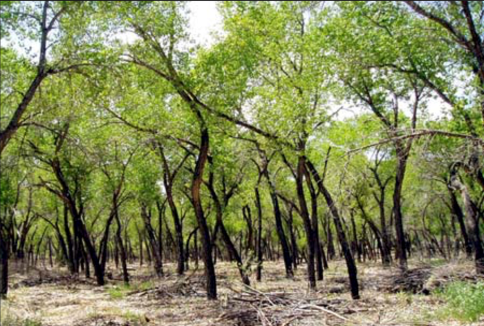
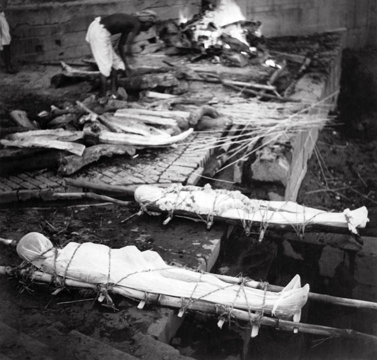

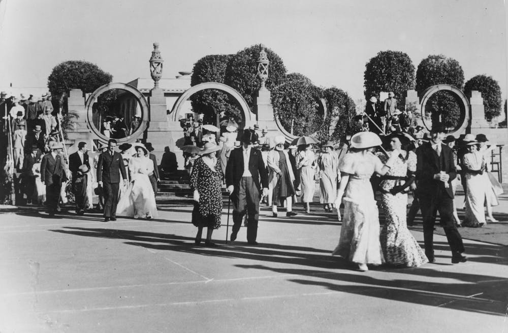


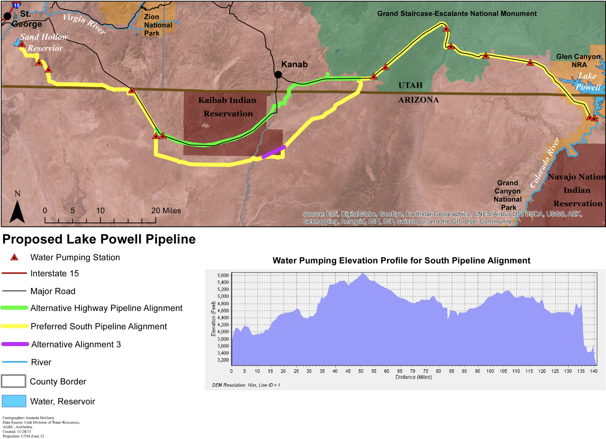
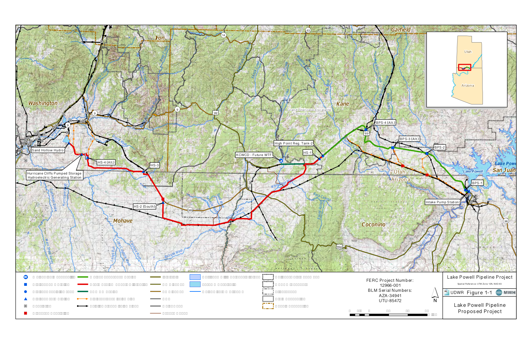
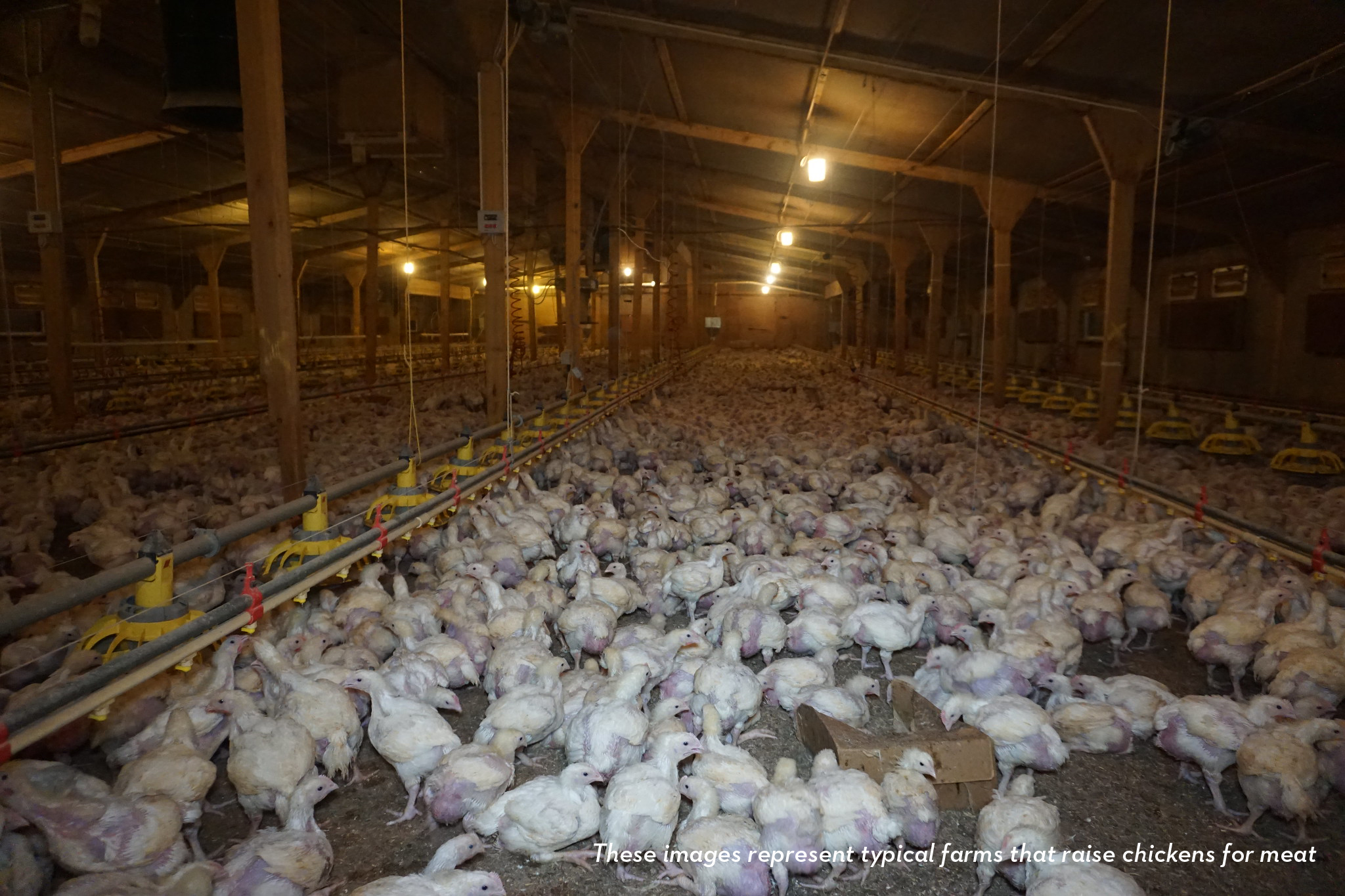
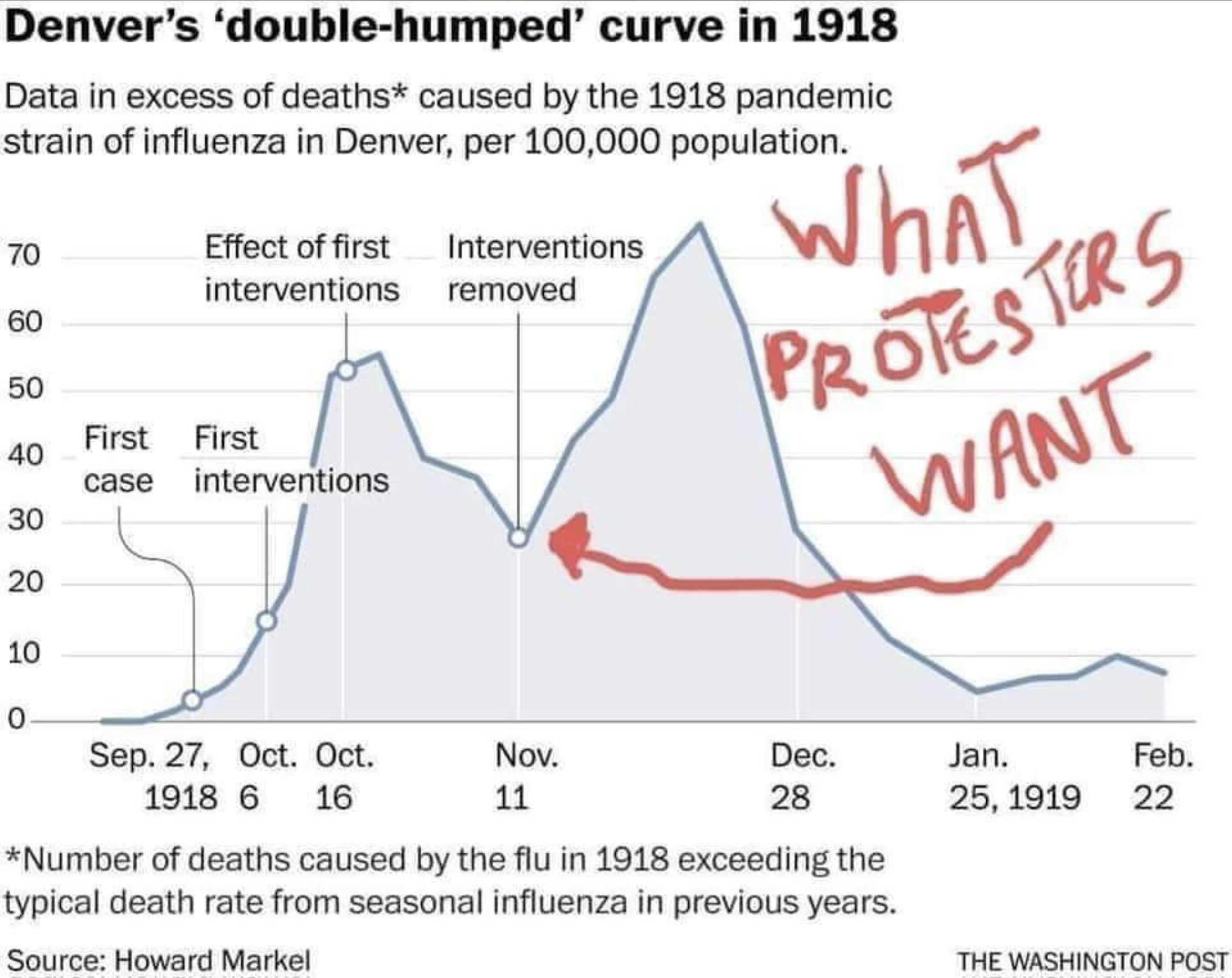
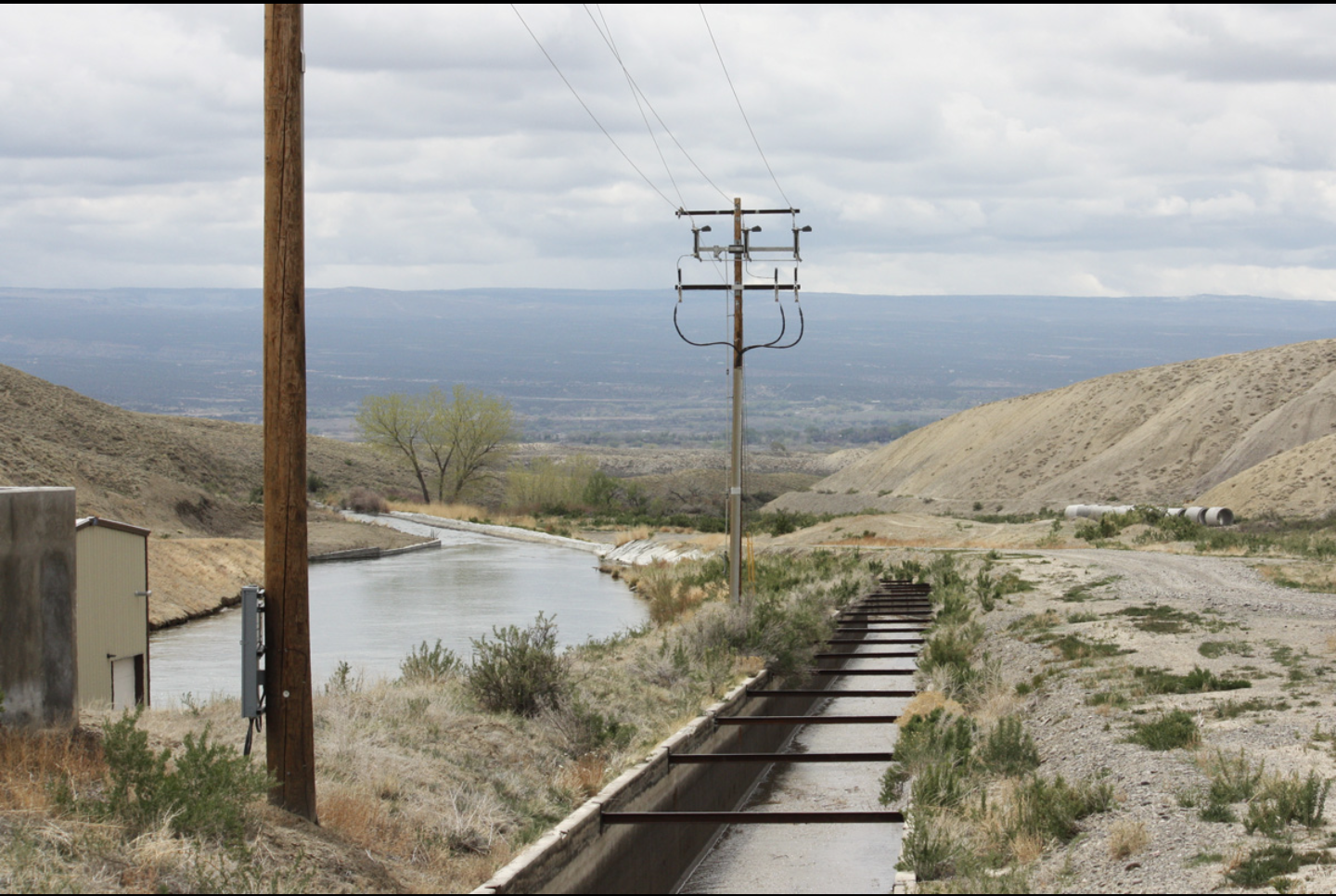
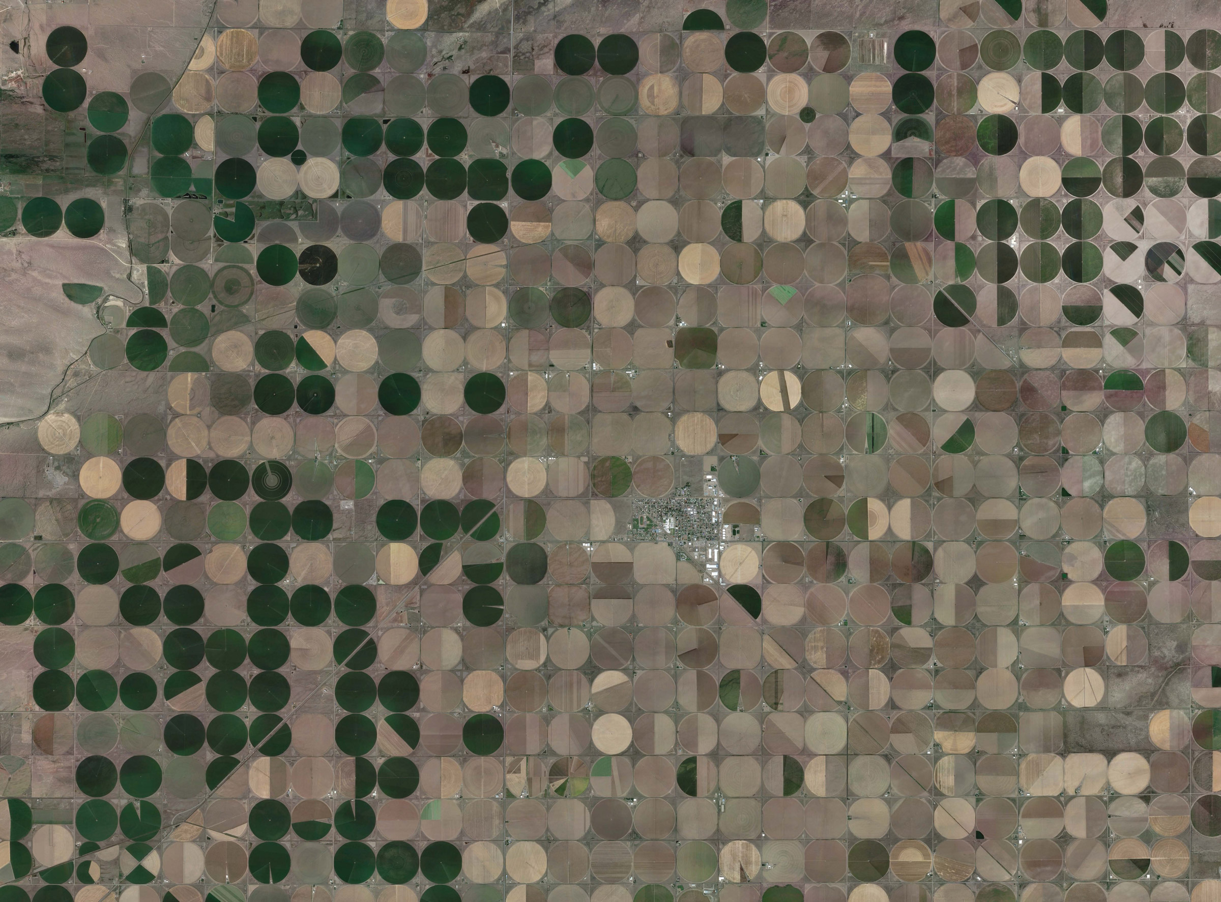
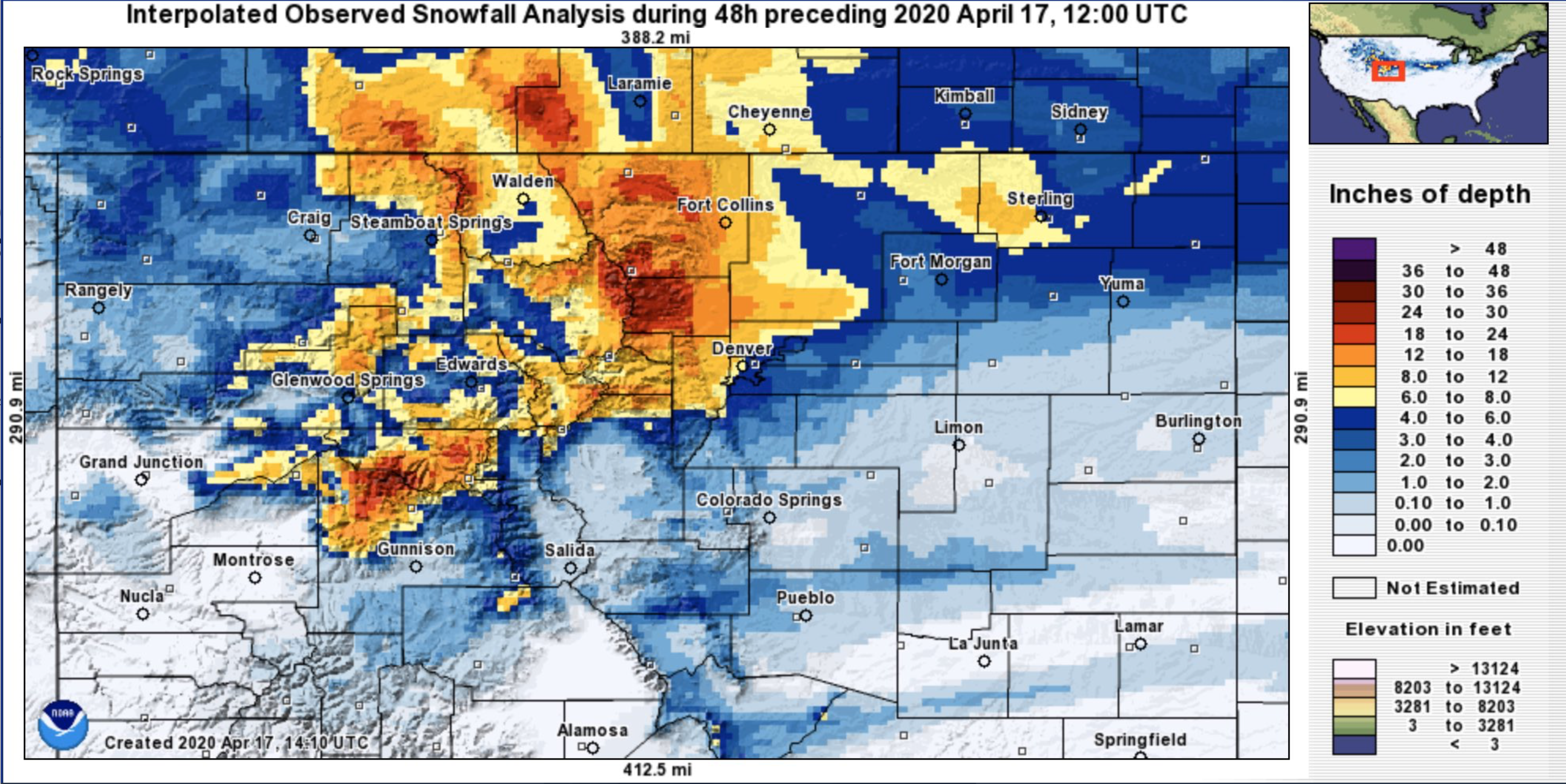

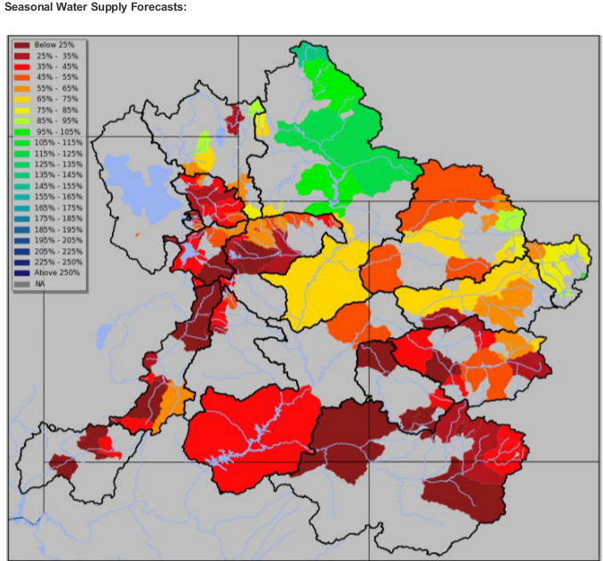
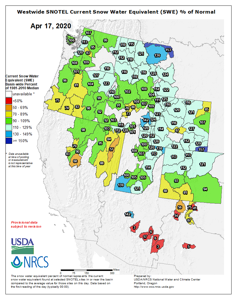

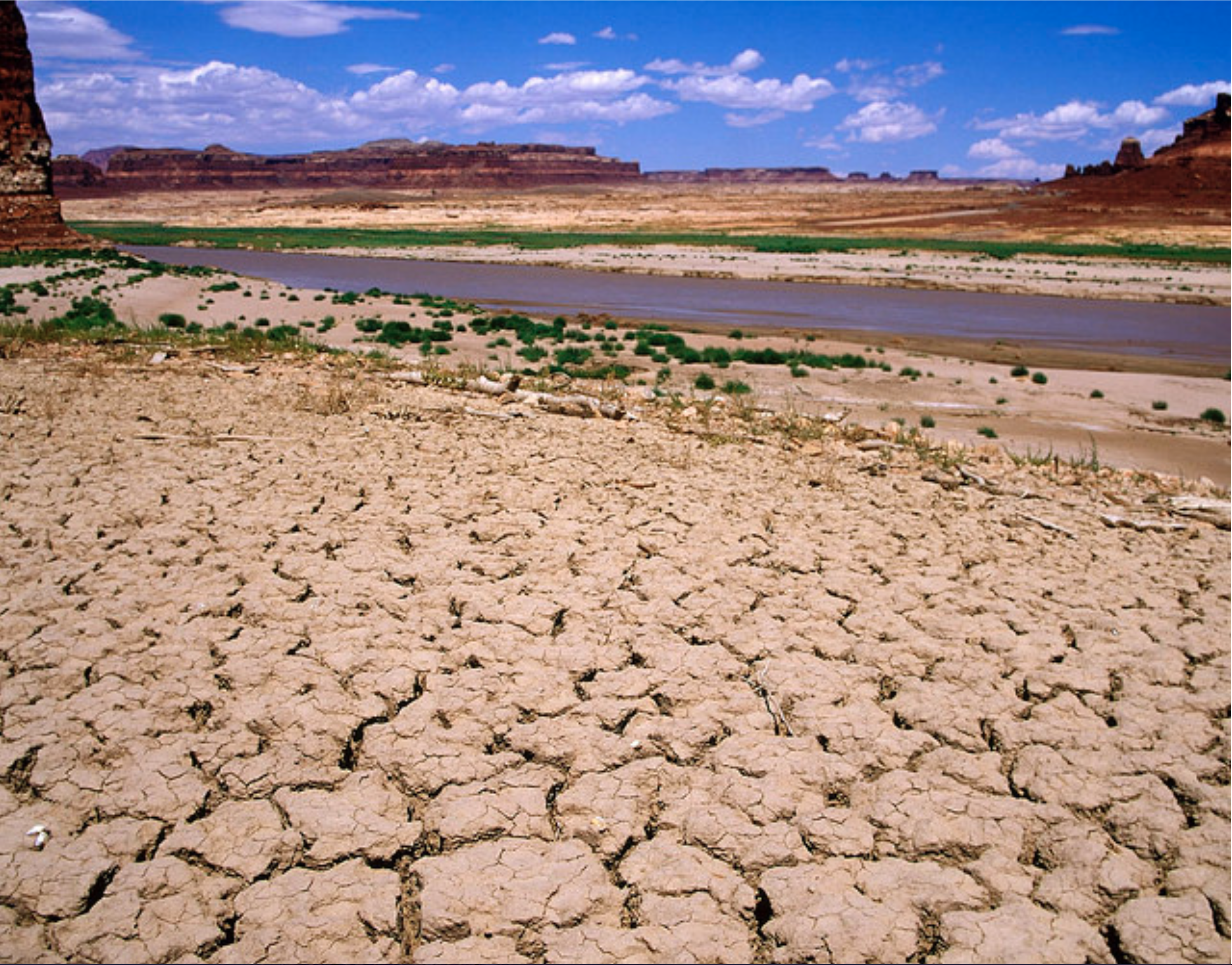


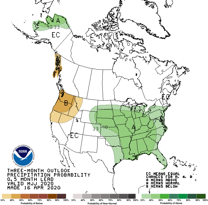
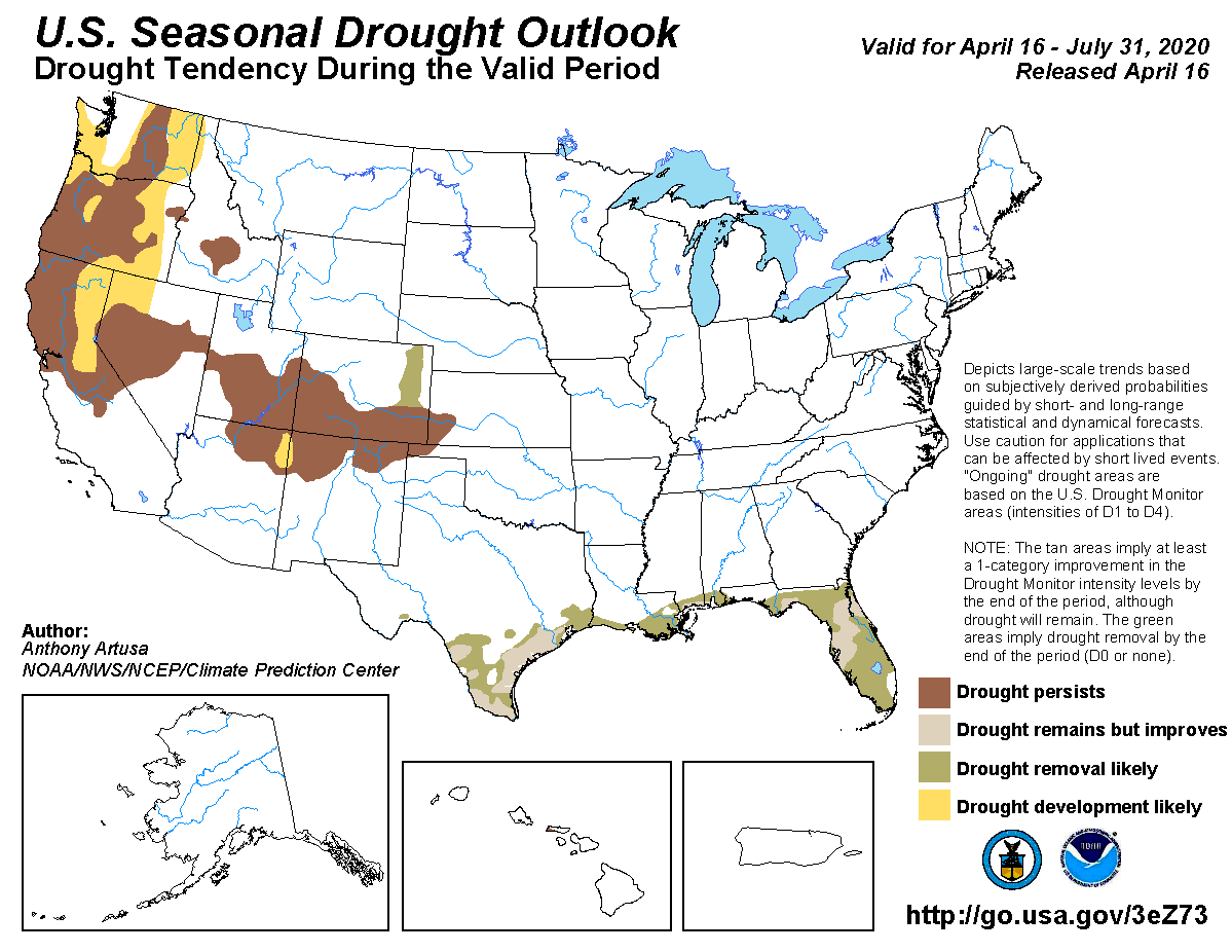

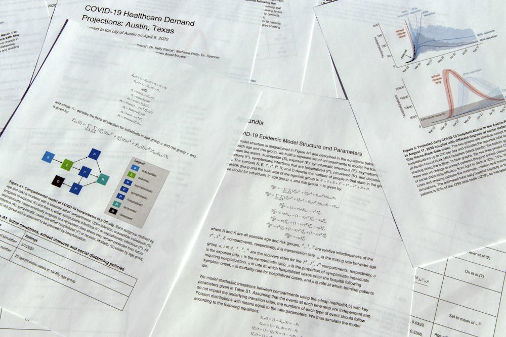


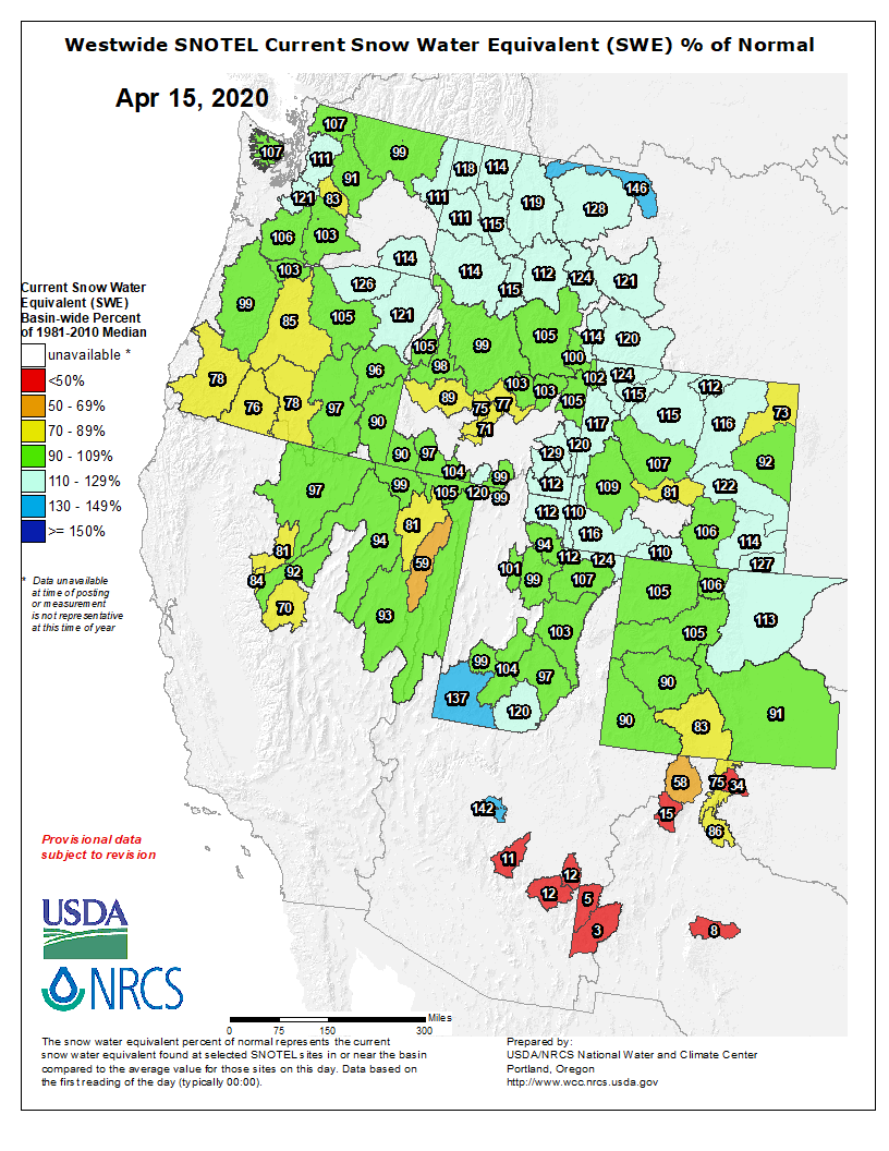

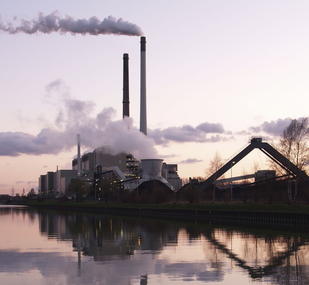
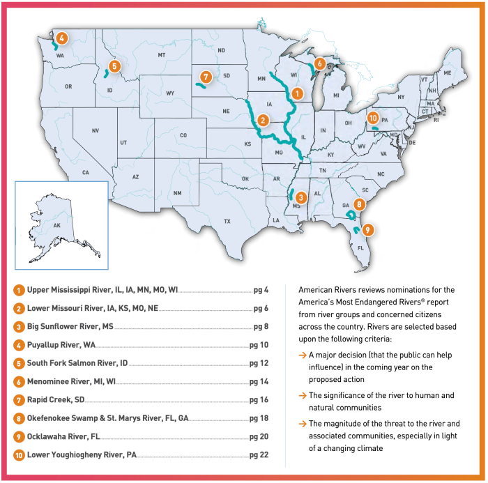


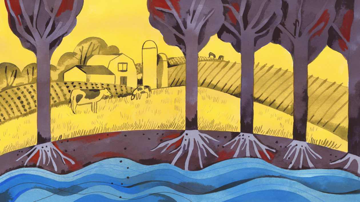
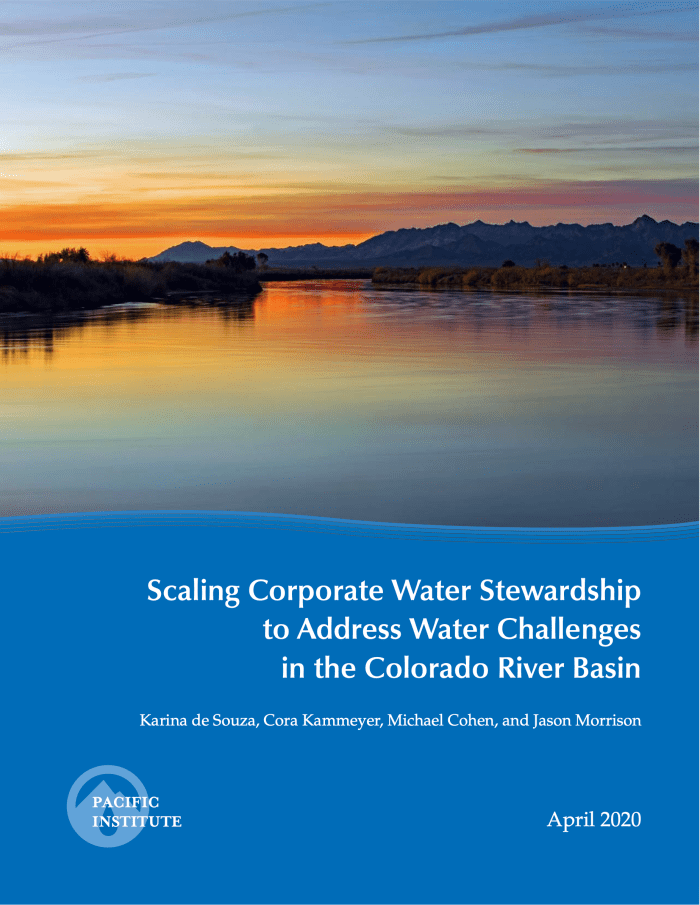

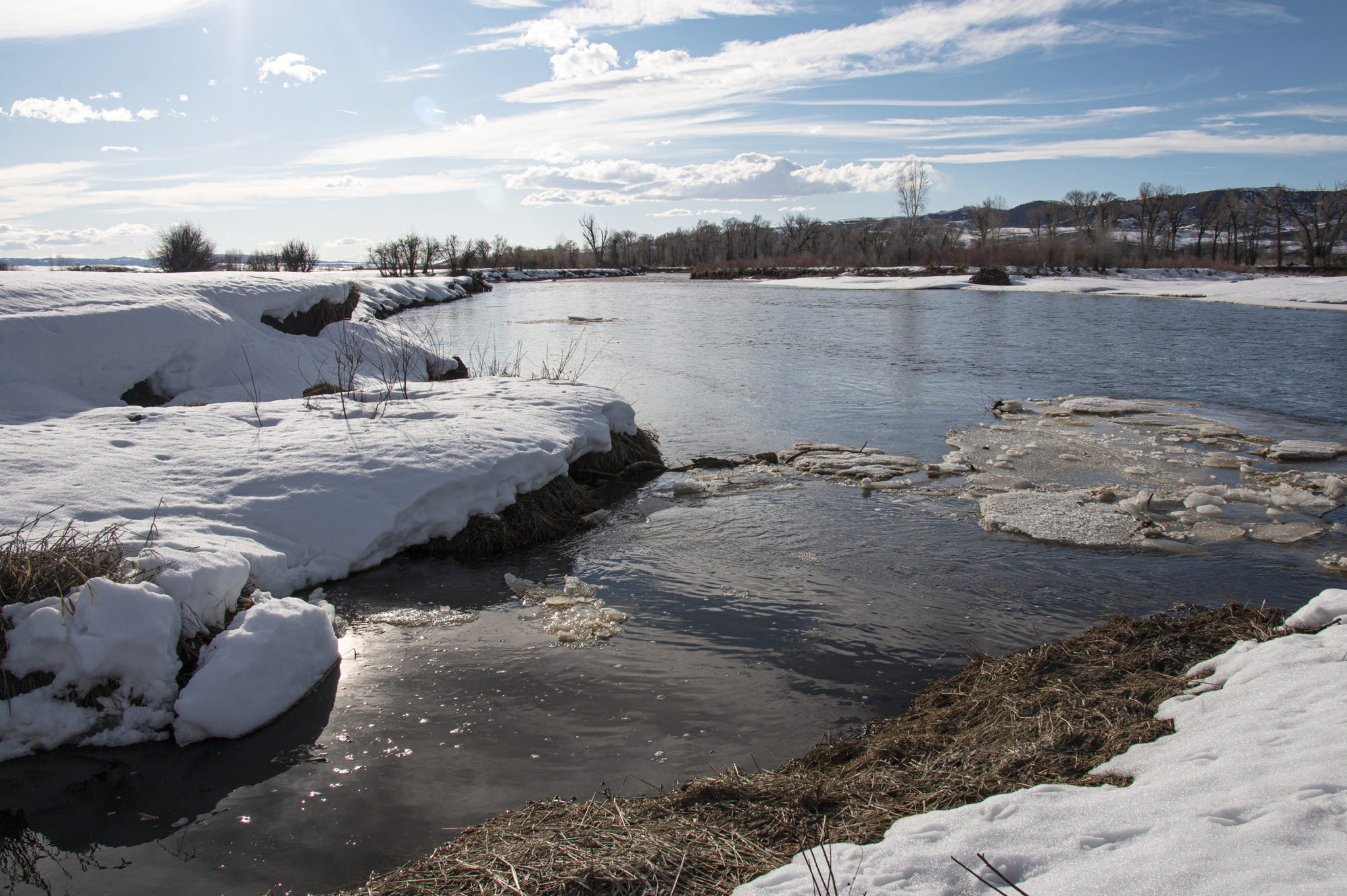

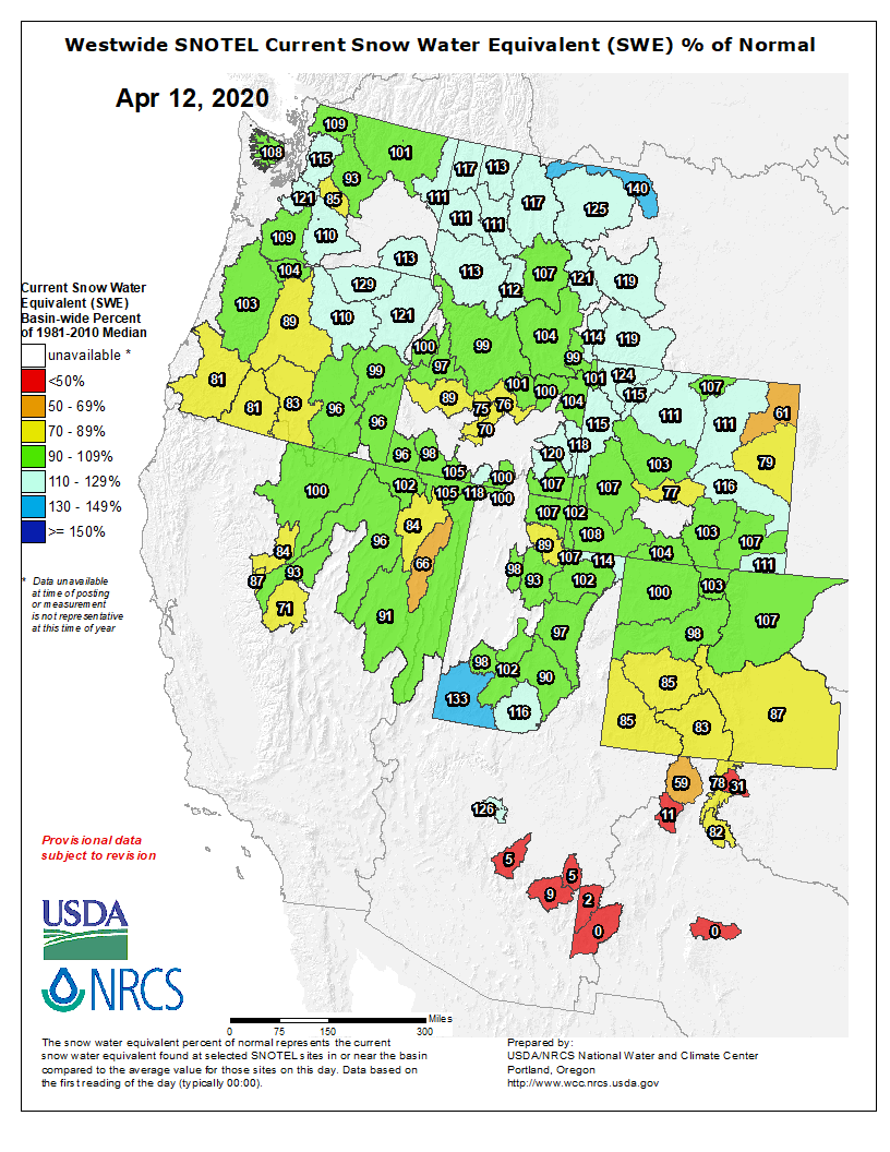
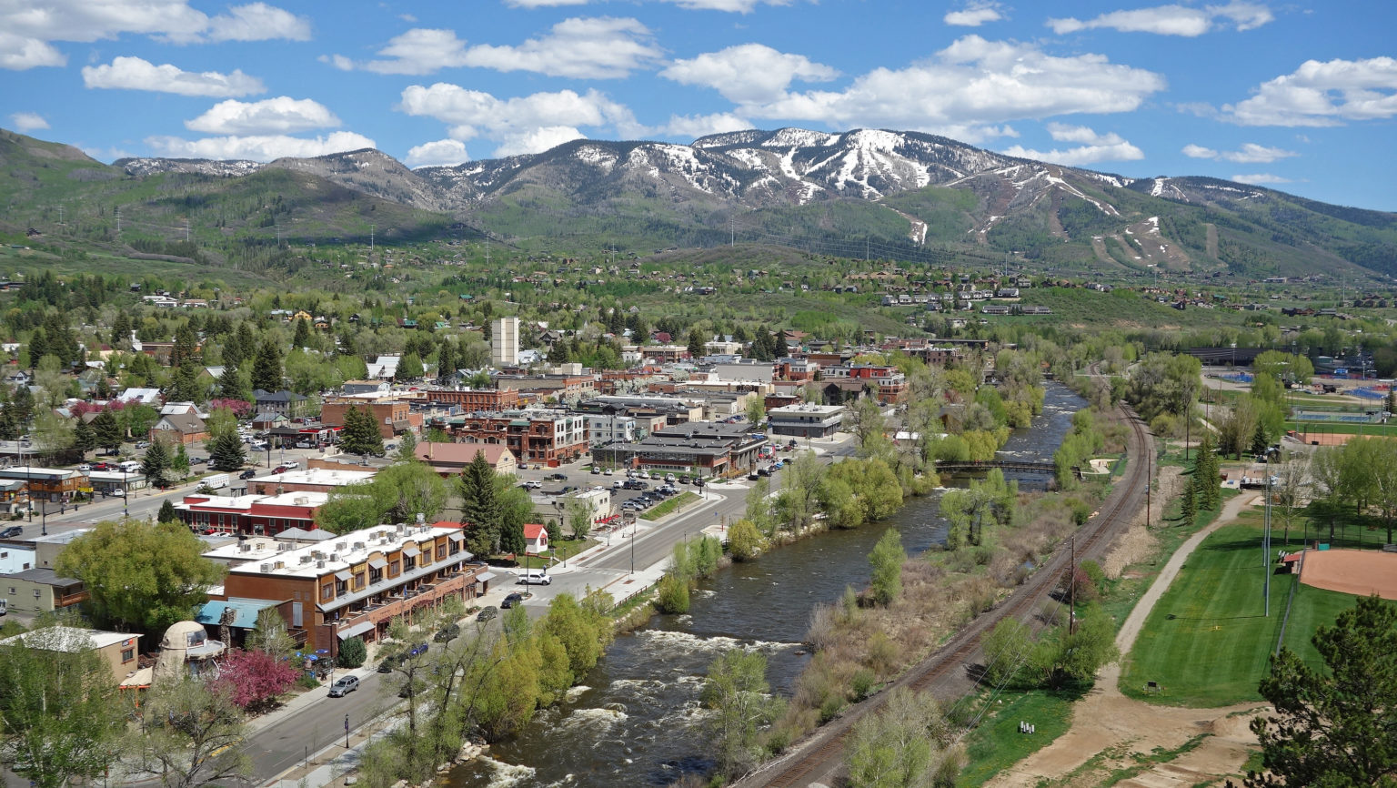


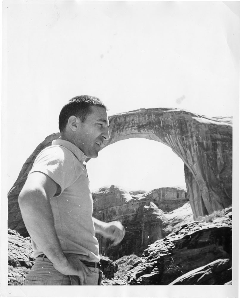
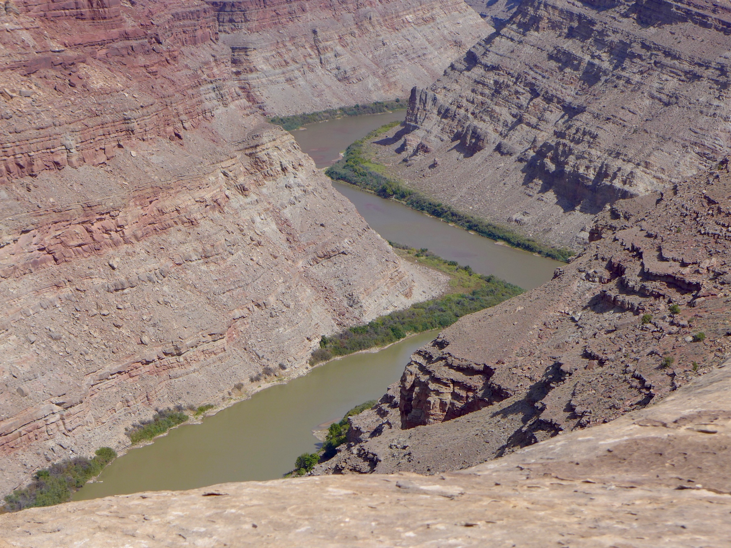


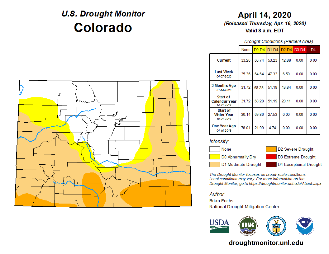


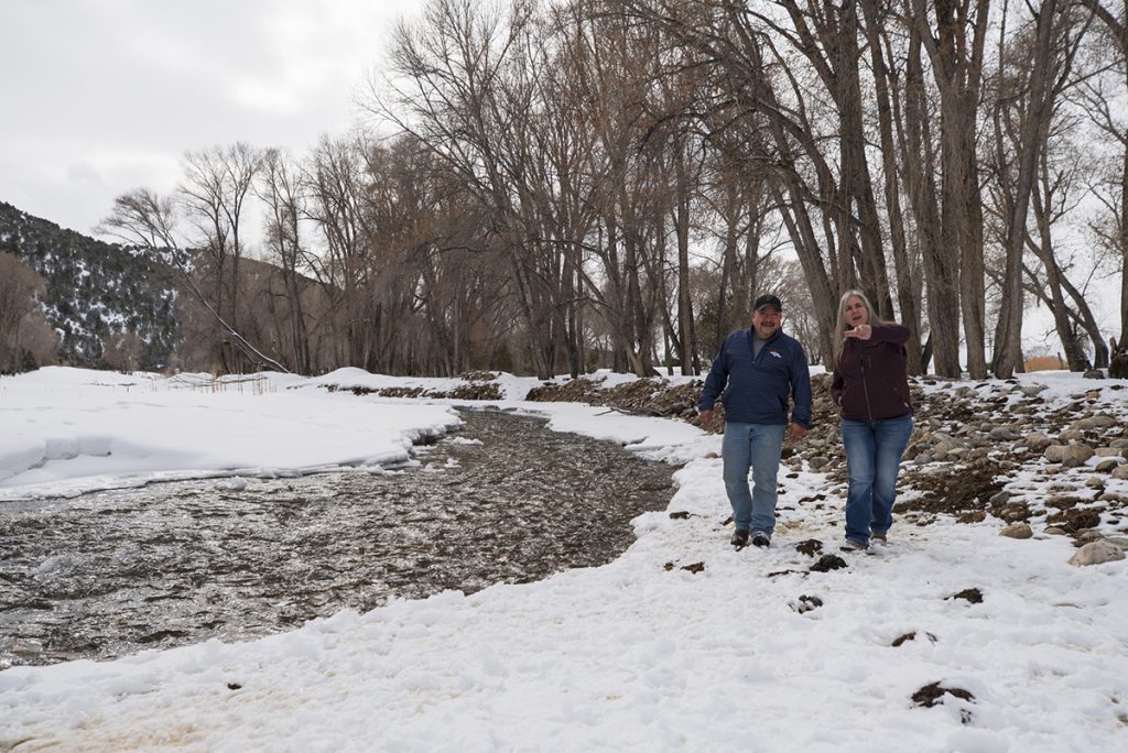
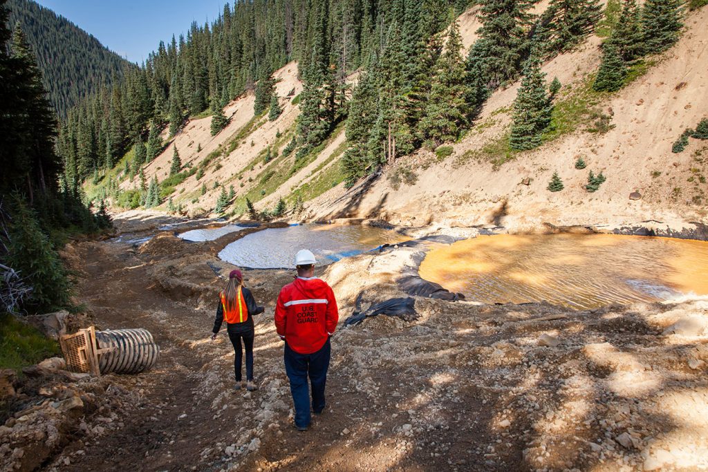


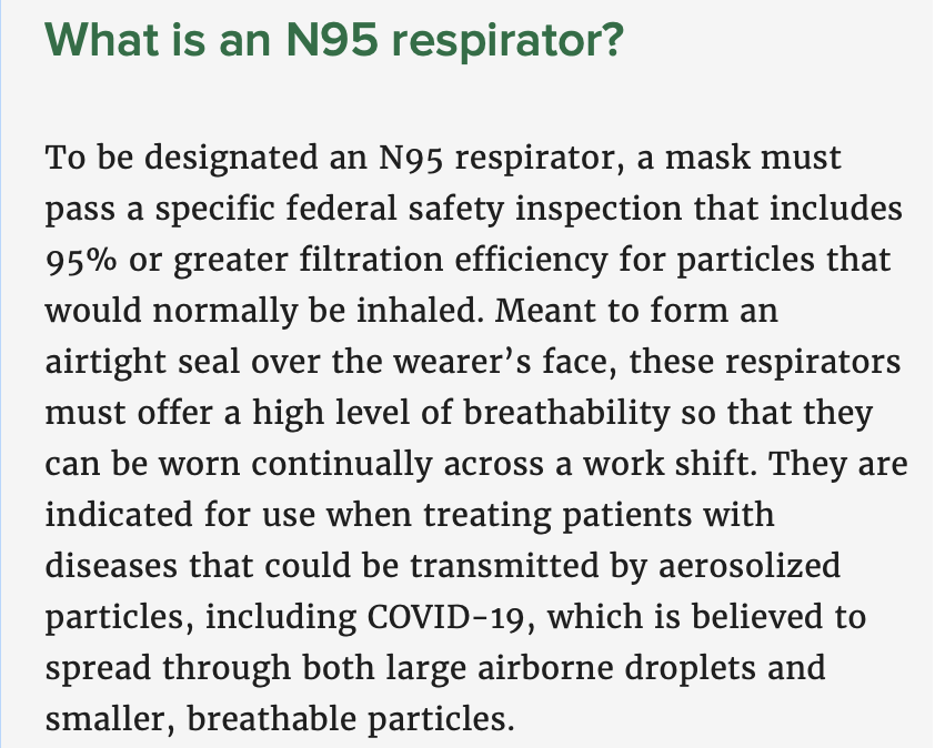


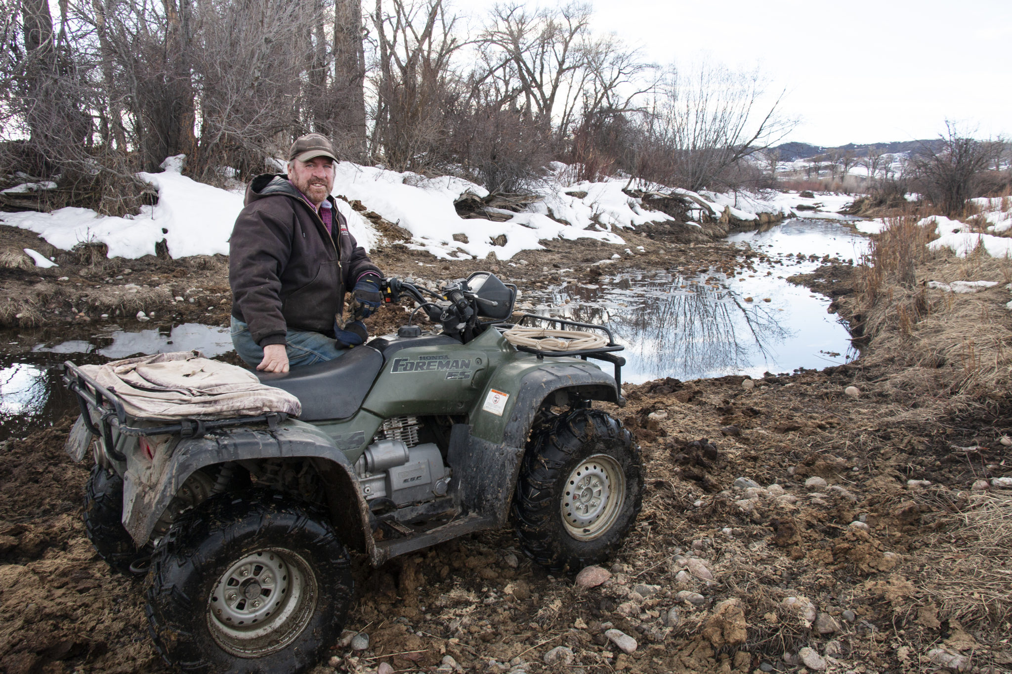
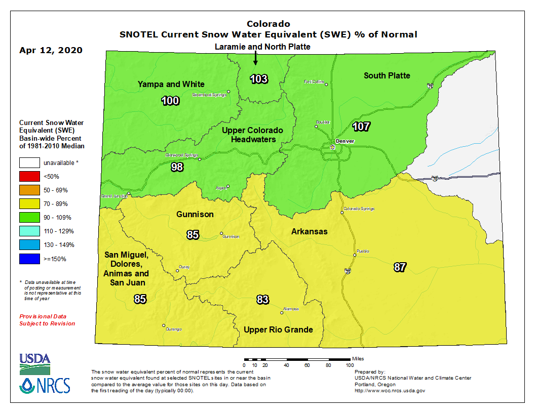
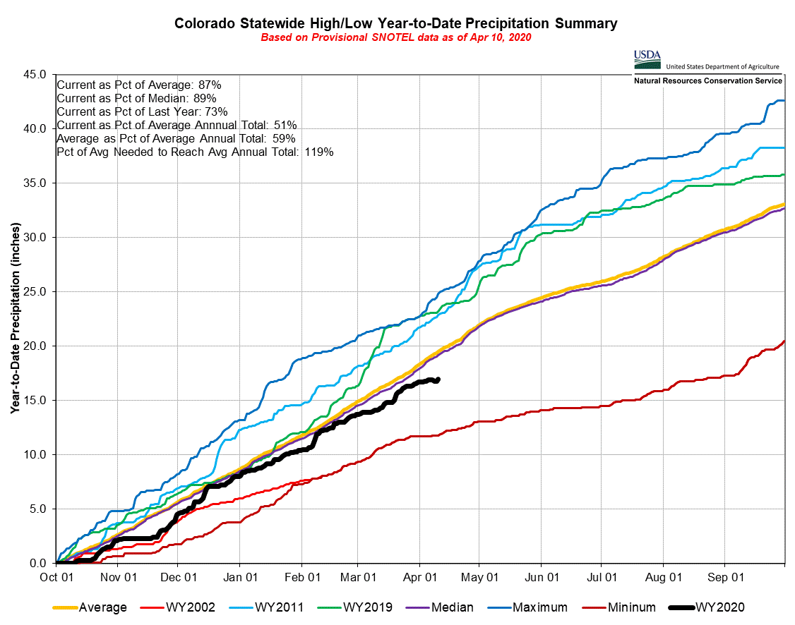


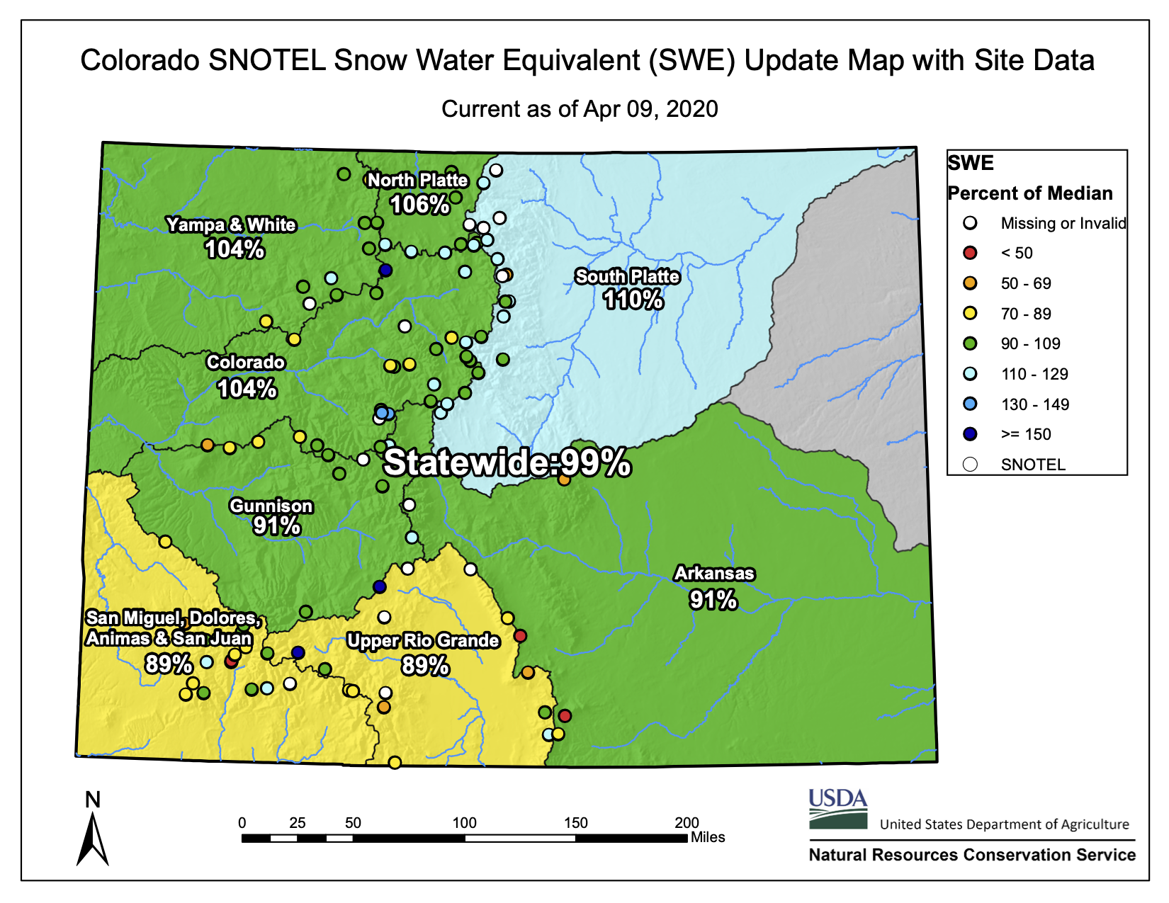