More than 100,000 miles of U.S. rivers and streams are polluted by nitrogen and phosphorus, much of it from agricultural runoff. In Pennsylvania, an innovative program is showing farmers how to plant cash crops in buffer zones to help stabilize stream banks and clean up waterways.
In Chester County, Pennsylvania, about 40 miles northwest of Philadelphia, Beaver Run carves a triangular piece of bottomland as it turns east to join French Creek. A gnarled old American sycamore grows in the narrow fringe of native forest bordering the stream. On a cold, gray winter’s day, agroforester Austin Unruh pulls on a woolen beanie and points out the variety of saplings poking through the straw-colored carpet of dormant grasses beyond the thin band of forest.
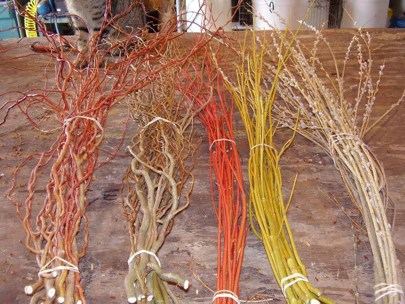
“Over there are American persimmons and pawpaws,” he says, identifying two of the native fruit-bearing trees he planted on the 3-acre corner of land. Scattered among them are ornamental natives such as red-twig dogwood and willows, which fetch a good price in the floral trade, he explained. With a state-funded grant from the nonprofit Stroud Water Research Center in Avondale, Pennsylvania, Unruh leased the land from Lundale Farm to demonstrate how agroforestry can be employed to create a new kind of pollution-fighting landscape called a “working buffer.”
A few hundred years ago, forests grew naturally along waterways in the eastern United States, but many have been razed to make way for towns, cities, cattle, and crops. Today, strips of streamside land replanted with native floodplain trees and shrubs, called riparian forest buffers, are essential to the health of creeks and rivers. These buffers help stabilize stream banks and decrease flooding while trapping and filtering pollutants that would otherwise end up in local waterways. Until recently, however, restoring a streamside buffer in rural areas meant taking farmland out of production.
Agroforester Austin Unruh in the buffer he created alongside Beaver Run. Courtesy of Eric Hurlock
Four years ago, with its push to create riparian forest buffers lagging far behind mandated targets, Pennsylvania established an innovative grant program to encourage farmers and landowners to plant working buffers that can yield cash crops. Unruh, who was working on a master’s degree in agroforestry, leapt at the opportunity. In addition to planting the Lundale Farm buffer, he founded Crow and Berry Land Management to help farmers in the Delaware and Chesapeake basins, the two major watersheds in eastern Pennsylvania, take advantage of state and private funding to design, plant, and maintain working buffers on their own lands.
From Lundale Farm, French Creek meanders southeast to the Schuylkill River, which continues on a winding course down to Philadelphia, where it joins the Delaware River. Stretching 330 densely populated miles from New York’s Catskill Mountains to the Atlantic Ocean, the Delaware is the lifeblood of the region, providing drinking water for more than 13 million people, including residents of New York City. The river and its web of tributaries also sustain countless orchards, dairy farms, corn and soybean fields, and nurseries. According to the Pennsylvania Association of Conservation Districts, almost 27 percent of the watershed is agricultural, a mixture of cropland and pasture.
As storm water runs off of farmland, it can wash away not only pesticides and soil but also nutrients such as nitrogen and phosphorus from commercial fertilizers and manure. These pollutants enter upstream waters, such as Beaver Run, and end up in larger water bodies like the Delaware, degrading water quality by promoting algal blooms that can harm aquatic species by depriving them of oxygen. They also create toxins and compounds in surface and groundwater supplies that can be harmful to human health.
The problem extends well beyond the Delaware watershed. According to the Environmental Protection Agency (EPA), more than 100,000 miles of U.S. rivers and streams have poor water quality because of nitrogen and phosphorus pollution, which the agency calls “one of America’s most widespread, costly, and challenging environmental problems.”
Riparian buffers not only help filter out fertilizers and other pollution. By shading streams and producing woody debris, they enhance aquatic habitat and provide food, cover, and nesting sites for birds and other animals. They also sequester carbon. The wider the buffer, the greater its benefits.
“Riparian forest buffers are a primary method that Pennsylvania is looking at for reducing its water quality problems,” says Tracey Coulter, agroforestry coordinator at the state Department of Conservation and Natural Resources (DCNR). For example, the state is responsible for fully 65 percent of the nitrogen and phosphorus polluting the Chesapeake Bay. As part of a newly updated Watershed Implementation Plan that lays out how the five states in the Chesapeake Basin intend to reduce the nutrients flowing into the bay to levels required by the EPA, Pennsylvania has committed to planting 85,650 new acres of riparian forest buffers by 2025. “It’s a massive goal, especially compared to what the rate of implementation has been lately,” says Lamonte Garber, watershed restoration coordinator at the Stroud Water Research Center.
For the past two decades, most buffers have been financed by the Conservation Reserve Enhancement Program (CREP), a federal initiative that covers 50 percent of the cost of planting riparian forest buffers at least 35 feet wide, and 100 percent for buffers 50 feet or wider. The farmers also receive a land rental check for 10 to 15 years. In return, farmers are prohibited from generating income from the buffers. CREP also requires that farmers maintain the buffers for the first three to five years while the plantings become established.
But participation in CREP has lagged, in part because farmers are reluctant to retire cropland. “Non-productive land is an anathema for farmers,” says Coulter. Many Pennsylvania farms are small, family enterprises, and in the words of Chris Kieran, senior associate of the William Penn Foundation’s watershed protection program, “the smaller the farm, the more valuable each individual acre is to the overall operation.” Many farmers also balk at the hassle involved in dealing with the federal government. In addition, most Amish and Mennonite farmers, who work a good deal of acreage in Pennsylvania, don’t believe in taking money from the government.
A recently planted riparian buffer in Dayton, Pennsylvania. The saplings are in tree sleeves to protect against deer and rodent damage. Courtesy of Clearwater Conservancy
The problem is compounded by the fact that many of the early buffers created under CREP suffered from a lack of maintenance. If there’s nothing to harvest in the buffer, maintenance often takes a back seat to other pressing farm tasks, says Coulter. “We need a way to make the buffers important to farmers,” she says.
Pennsylvania sees working buffers as a compromise that protects water quality while allowing farmers not participating in CREP to earn a living from their land. A 1998 study by University of Maryland researchers concluded that buffers can gross nearly $25,000 per acre annually. According to Jeremy Kaufman, chief operating officer of Propagate Ventures, which works with farmers to make buffers and other forms of agroforestry economically viable, “fruit and nut crops yield a much higher return per acre than a row crop operation.”
As envisioned by Pennsylvania officials, working buffers consist of three zones. While conventional forest buffers must extend at least 35 feet from the water’s edge, the strip of native woodland that comprises zone one of a working buffer can be just 15 feet wide. The principle objective of this zone is to stabilize the bank with tree roots and enhance wildlife habitat.
The second zone, which extends 15 to 35 feet from the water, is planted with trees and shrubs that can tolerate periodic flooding. In addition to slowing floodwater and taking up nutrients, this zone is designed to provide products for profit or personal use. For example, black walnut, American hazelnut, pawpaw, American persimmon, and common elderberry can tolerate the conditions in this area and yield salable fruits and nuts. To minimize soil disturbance, only hand harvesting is permitted in zone two.
Coulter calls zone three, which is adjacent to crop fields or grazing lands, “the most commercial part of the buffer.” In this zone, mechanical harvesting is allowed. Candidate crops require slightly drier soils, such as blueberry and black raspberry, as well as decorative “woody florals” such as curly willow, wild hydrangea, pussy willow, and winterberry holly.
In addition to edible fruits, nuts, mushrooms, and cut stems for the floral trade, advocates say, working buffers with beehives can produce income from honey. Depending on the location, working buffers can also yield high-value medicinal plants like ginseng and black cohosh. Mulberries and other trees can provide fodder for livestock, an attraction for dairy farmers.
How many farmers and landowners can be enticed to create working buffers remains to be seen. To date, most have been established by small landowners philosophically committed to land stewardship. This has fueled concerns that the concept could remain a cottage industry and never really spread across the landscape at a scale that would make a real difference for water quality.
“My hunch is that the number is going to be small, less than 10 percent of landowners out there who have significant stream frontage,” says Garber of the Stroud Center. “It may be an incentive for small-scale niche farmers who may have 5, 10, or 20 acres,” he says, but not for the majority of “production farmers” such as dairy operations and corn and soybean growers. “Most of those farmers have their hands full with their existing farm enterprise,” says Garber.
Some researchers at the Stroud Center, which in recent decades has done much of the research on the effectiveness of conventional riparian forest buffers, also worry that working buffers may lose some pollution-reduction power when the native forest portion is downsized and replaced with tree and shrub crops. Until proven otherwise, Garber says policymakers should not be tempted by the current enthusiasm for working buffers to stop funding and improving CREP and other traditional buffer programs.
Woody florals such as dogwood and willows can be grown in buffers and marketed to the floral trade. Courtesy of Illinois Willows
A growing number of entrepreneurs like Unruh and Kaufman are leading the transition to low-impact “regenerative” farming that integrates trees and shrubs with traditional crops, not only in working buffers but also pastures, windbreaks, and narrow, widely spaced rows of trees that produce nuts and other valuable products in the midst of traditional crops, a technique called alley cropping. However, these forms of agroforestry are unfamiliar to most American farmers. Another impediment to the adoption of working buffers as envisioned by the state is that hand harvesting is necessary, making them more labor-intensive than crops like corn and soybeans that can be harvested mechanically.
What’s more, you can’t just leave a load of persimmons at the local grain elevator. The marketing and distribution infrastructure for such products does not yet exist. “We’re trying to work out strategies for these things,” Coulter says. Among the solutions under discussion are co-ops, such as the Midwest Elderberry Cooperative in Minnesota and a woody floral co-op in Nebraska.
Most farmers are used to thinking in annual cycles, says Kaufman, so “the 20- or 30-year investment entailed with working buffers can be a challenge for them.” To allay their concerns, Propagate Ventures brings a variety of potential partners to the table with farmers willing to consider creating a working buffer. Among them are ecologically minded investors, including companies that can market their support of low-impact agriculture on their product labels. “Farmers need to know that a buyer will be available” when the tree crops begin to bear fruit, says Kaufman. Putting together the right kind of investment arrangements, purchase and lease agreements, and management and maintenance contracts is critical to making this kind of farming work, Kaufman says.
According to Unruh, states and the federal government have employed a “cookie-cutter approach” to streamside buffers, concerned only with improving water quality. If working buffers are to succeed, he says, they must incorporate the needs of individual farmers as well. “Taking a holistic approach, looking at the whole farm and not just the buffer is key,” says Kaufman. “So someone accustomed to growing grain might be more interested in a hay-production crop between rows of trees than dealing with elderberries or other shrub fruits,” he says.
This spring, Propagate Ventures and the Stroud Center will be identifying three farms willing to pilot working buffers and to work out business models for them. Meanwhile, the Pennsylvania Infrastructure Investment Authority (PENNVEST), a partner in the state’s grant program for working buffers, is keeping track of the costs the buffers accrue and the income they generate. The authority, which traditionally has managed revolving loans for sewage, storm water, and drinking water projects, hopes to do the same for working buffers. But right now there is little data to support a business plan and complete data from the farms they have funded won’t be available for three or four years, says PENNVEST executive director Brion Johnson.
“The real long-term sustainable solution,” he says, “is to move away from just grants to a low-interest, revolving loan program that can support these buffers 20, 30, 40 years into the future.”
Janet Marinelli is an award-winning independent journalist who was director of scientific and popular publications at Brooklyn Botanic Garden for 16 years. She has written and edited several books on imperiled species and the efforts to save them. She also covers ecological approaches to creating resilient landscapes and communities. Her articles have appeared in a variety of publications, from The New York Times and Audubon to Landscape Architecture and Kew magazine.
Here’s the release from Colorado State University (Anne Manning):
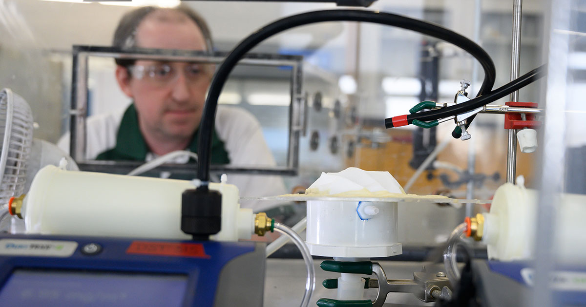
Professor John Volckens’ 2,000-square-foot lab on the campus of Colorado State University is normally a place for experiments on air quality, pollution sensors, and how breathable particles can trigger disease.
Over the last two weeks, the lab has suspended most of its usual activities and transformed into the official testing site for respirators and surgical masks for distribution throughout the state of Colorado. These forms of personal protective equipment are critical for ensuring the safety of front-line medical workers who are battling COVID-19 every day.
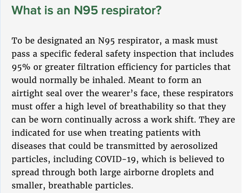
On March 25, Gov. Jared Polis announced that CSU, and specifically the Center for Energy Development and Health which Volckens leads, is the state’s designated center for evaluating the safety and efficacy of protective gear, mostly medical masks, that are made by different vendors and sources and are destined for Colorado hospital workers. CSU’s role is to initiate and coordinate testing and provide recommendations to the state on distributing such equipment. Primarily, the CSU team is focused on N95 particulate respirators that offer certified protection from aerosols in the workplace.
The only federal lab that regularly performs this type of N95 testing is in Pennsylvania. The state of Colorado has now designated CSU as, essentially, an emergency substitute for standard federal testing, to be done in-state for in-state needs.
Researcher Christian L’Orange prepares a mask for testing. Photo by Bill Cotton.
Shoring up supplies
The state estimates between 60,000 and 100,000 disposable masks and other protective items, per day, will be needed for Colorado healthcare workers in coming weeks and months. In an effort to stave off shortages, the state has kicked into high gear to stockpile supplies, and CSU is at the forefront of making sure the masks in particular will work to specifications.
“Our lab has the facilities and engineering expertise to perform those tests,” said Volckens, a professor in mechanical engineering and environmental and occupational health. “We can essentially mimic the stringent requirements put forth in the federal protocol.”
Volckens and his team have toiled furiously since March to get the lab ready to run mask tests, as shipments come in from various vendors. For any given type of mask, it can take several hours to complete a test.
N95 test steps
The N95 inspection involves a number of steps, said Christian L’Orange, a CSU professor of research practice who is performing the majority of the tests. First, the mask is conditioned at a set temperature and relative humidity, then sealed down to a fixture. The mask is then placed in an environmental aerosol chamber, where particles are drawn through it. Sophisticated equipment is used to count the number of particles upstream and downstream of the mask, as a measure of its efficiency. The researchers must also perform a breathability test, because the mask’s safety is tied to how easily the wearer can breathe through it.
“It’s not just about how well it filters,” L’Orange said. “A mask with too much of a pressure drop actually puts too much burden on the person breathing through it, which can be downright dangerous.
L’Orange seals a mask to a frame with beeswax to prepare it for testing. Photo by Bill Cotton.
The N95 tests simulate real working conditions with high dust loadings, which can include viral particles. The researchers are following National Institute for Occupational Safety and Health protocols for N95 masks, which are used in many trades and occupations – not just health care.
“It’s a worst-case scenario test,” Volckens said.
The testing looks at particle penetration only, not fluid spills or splatters, Volckens added. To test each lot of masks that comes in, the researchers will take a statistically valid sample and require that every mask in that sample pass quality standards, adhering identically to those published by NIOSH.
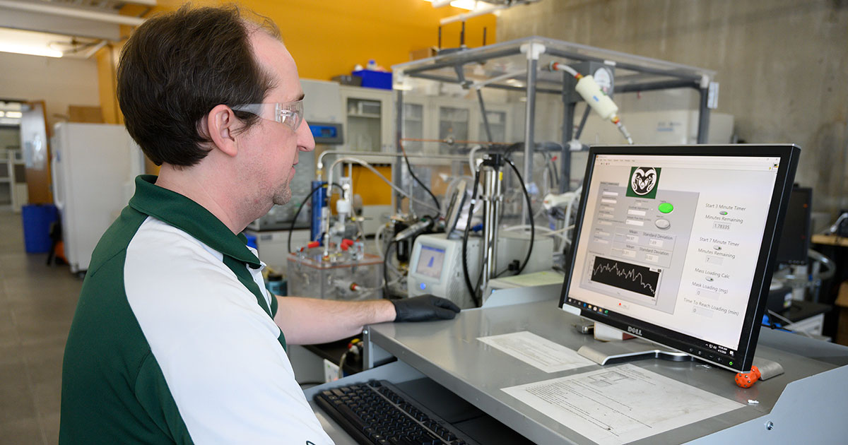
During testing, researchers monitor values of particle filtration efficiency for each mask. Photo by Bill Cotton.
In the lab, L’Orange is leading overall procedure design, and lab manager John Mehaffy is prepping masks for testing. Postdoctoral researcher Jessica Tryner is performing data analysis so that results can be immediately processed and shared with the state. The team operates from different locations in order to limit personal contact and further protect their health.
“We don’t know how long this need will go on, but we will continue to serve the state until they tell us we’re in good shape and we can stop,” Volckens said.
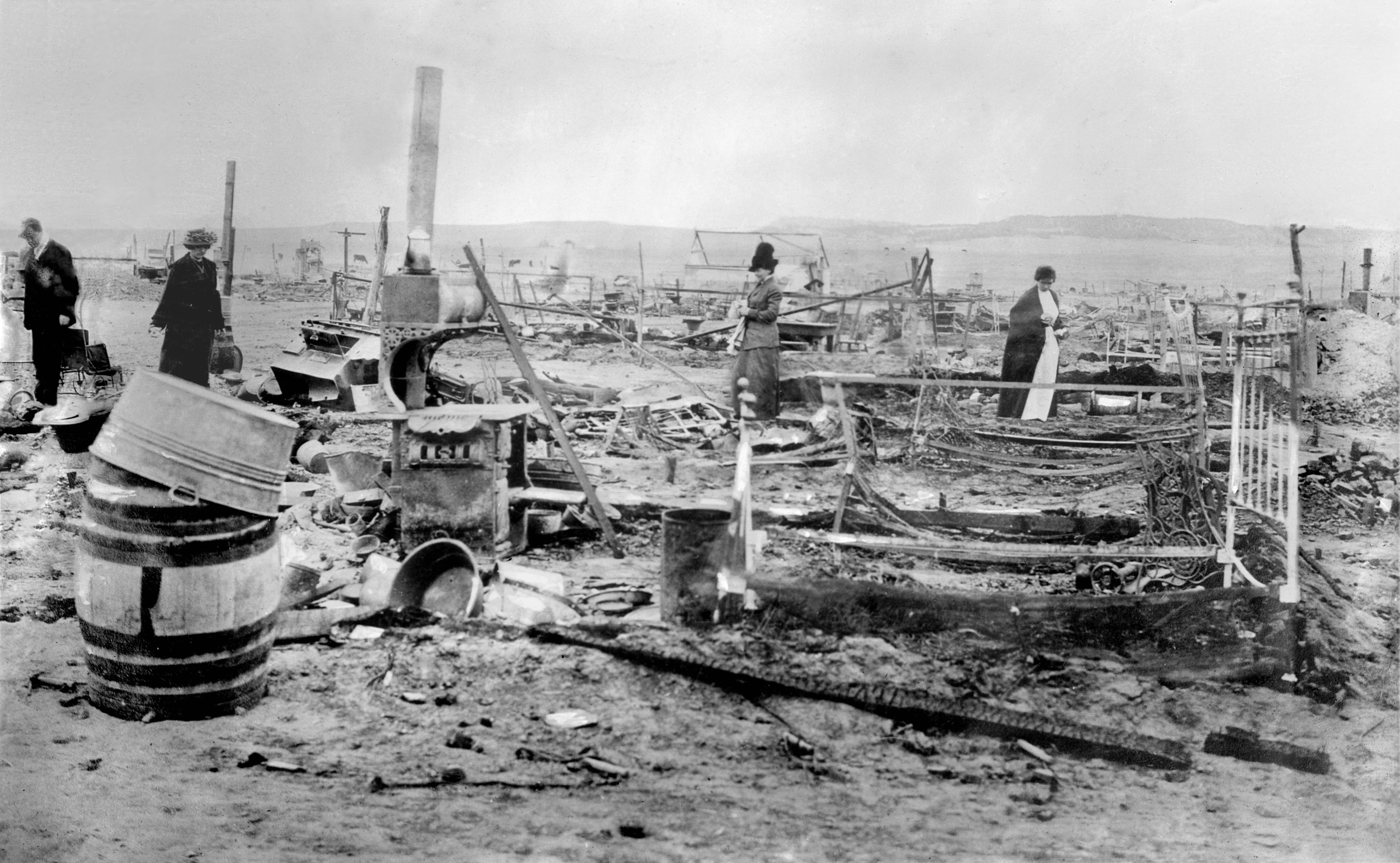
Ruins of the Ludlow Colony near Trinidad, Colorado, following an attack by the Colorado National Guard. Forms part of the George Grantham Bain Collection at the Library of Congress. By Bain News Service – This image is available from the United States Library of Congress’s Prints and Photographs divisionunder the digital ID ggbain.15859.This tag does not indicate the copyright status of the attached work. A normal copyright tag is still required. See Commons:Licensing for more information., Public Domain, https://commons.wikimedia.org/w/index.php?curid=10277066
FromThe Columbia Journalism Review (Savannah Jacobson):
The story of oil company propaganda begins in 1914, with the Ludlow Massacre. In Ludlow, Colorado, a tent city of coal miners went on strike, and officers of the Colorado National Guard and the Colorado Fuel and Iron Company responded violently. At least sixty-six people were killed in the conflict, turning popular opinion against John D. Rockefeller Jr., who owned the mine in Ludlow. To recover public trust, Rockefeller hired Ivy Ledbetter Lee, a public relations agent, to peddle falsehoods disguised as objective facts to the press: the strikers were crisis actors; the violence was the fault of labor activist Mother Jones; there was no Ludlow Massacre.
Rockefeller’s company, Standard Oil, evolved into what is now ExxonMobil, and its original PR strategy remains. Throughout the 1970s and ’80s, Exxon commissioned scientific reports that documented the potentially catastrophic effects of carbon dioxide emissions. But in the decades that followed, Exxon buried those reports and told the public the opposite: that the science was inconclusive, that regulation would destroy the American economy, and that action on climate change would mostly cause harm.
Exxon’s public mouthpiece was the press. For more than thirty years, from at least 1972 until at least 2004, the company placed advertorials in the New York Times to cast doubt on the negative effects of fossil fuel emissions. Over the same time span, ExxonMobil gave tens of millions of dollars to think tanks and researchers who denied the science of climate change. Taken in sum, Exxon’s media shrewdness and its aggressive political lobbying have set back climate action for decades—putting the nation, and the world, dangerously close to a point of no return.
Year by Year
1962
Humble Oil, a subsidiary of what would become Exxon, buys an advertisement in Life magazine reading, “Each Day Humble Supplies Enough Energy to Melt Seven Million Tons of Glacier!”
1977
Exxon executives learn from James F. Black, a scientist employed by the company, that the practice of burning fossil fuels releases such large amounts of carbon dioxide as to imperil the planet.
1982
Exxon’s researchers confirm published scientific findings: the level of CO2 output from fossil fuels could eventually raise the global temperature by up to 3 degrees Celsius.
1989
Spring: An Exxon tanker crashes into a reef, spilling 10.8 million gallons of oil into Alaska’s Prince William Sound. The disaster will be the second-largest spill in US history. In the following months, Exxon publishes a number of advertisements in the Times apologizing for the spill and asking readers to reject boycotts.
Summer: Mobil runs its first advertorial on global warming in the Times. It reads in part, “Scientists do not agree on the causes and significance of [warming]—but many believe there’s reason for concern…we’re hard at work along all these fronts. We live in the greenhouse too.”
Fall: The Global Climate Coalition forms with the mission to oppose action against global warming and to advocate for the interests of the fossil fuel industry by promoting doubt about climate science. Exxon is a founding member.
1997
The Kyoto Protocol is signed.
Mobil places an advertorial in the New York Times reading, “Let’s face it: the science of climate change is too uncertain to mandate a plan of action that could plunge economies into turmoil.”
2007
Exxon pledges to stop funding climate denialist public policy groups; however, a 2015 Guardian investigation showed funding did not stop.
2018
New York State pursues a civil case against ExxonMobil for defrauding investors about the risks of climate change, the first against the company to reach trial. The state asks for as much as $1.6 billion in damages; Exxon wins.
By the Numbers
$30.9M
Amount ExxonMobil spent, through 2012, to fund think tanks and researchers who denied aspects of climate change.
$2.3M
Minimum amount that ExxonMobil has paid since 2007 to lobbyists and members of Congress opposed to climate change legislation.
80
Percent of scientific studies ExxonMobil conducted internally from 1977 to 2014 that state climate change is man-made.
81
Percent of ExxonMobil’s advertorials published in the New York Times in the same time frame that cast doubt on the idea that climate change is man-made.
$300M
Exxon’s annual research budget during the height of the company’s climate science research, in the late 1970s to mid-1980s.
16
Years that Mobil placed weekly advertorials in the New York Times. After merging with Exxon in 1999, Mobil reduced advertorial placement in the Times to every other week.
74
Number of television networks and national and local newspapers that have cited Myron Ebell, a leading climate denialist, or published his opinion pieces from 1999 to the present.
$2M
Amount ExxonMobil gave to the Competitive Enterprise Institute, a libertarian think tank of which Ebell was a director, from 1998 to 2005.
40
Percent of Americans who opposed, in 2009, a significant clean energy bill.
63
Percent of Americans who opposed the same bill after the Heritage Foundation, an ExxonMobil-funded think tank, published a study that misleadingly claimed the bill would increase gas prices to
$4 per gallon.
Click here to read the report (Karina de Souza, Cora Kammeyer, Michael Cohen, and Jason Morrison). Here’s an excerpt:
Corporate water stewardship in the Colorado River Basin is still relatively nascent. Compounding this challenge is the lack of forums, relationships, and institutions to help bring together diverse water users, including companies, who do not typically collaborate on shared water challenges. Two key strategies for advancing the maturity and reach of corporate water stewardship in the Basin are (1) to expand water stewardship education, decision-making data, and starter tools about the value of water stewardship and (2) to facilitate local collaboration on water stewardship.
Strategy 1: Support Water Stewardship Education, Decision-Making Data, and Starter Tools at the Global Level
Support improved corporate reporting on water use and stewardship activities.
Support online educational and risk assessment tools to help companies get started.
Support investor-led efforts to engage companies in corporate water stewardship.
Strategy 2: Facilitate Local Action on Water Stewardship
Target engagement on water-intensive industries in the Basin.
Target value chain engagement on industries with important supply chains in the Basin.
Support platforms to facilitate relationship-building and knowledge sharing between companies and NGOs, water utilities, and other key water stakeholders.
A new analysis confirms drinking water or groundwater contamination at 328 installations across the country that have levels of “forever chemicals” that never break down and pose health risks.
Three of those incidences of contamination were confirmed in Utah including at Hill Air Force Base, Camp Williams and the Salt Lake City International Airport…
While these water samples may be confined to groundwater, the organization emphasized concerns over the adequacy of treatment for private wells and noncommunity providers that deliver water to a variety of facilities that include campgrounds.
Another four sites in Utah — all military — are suspected of having levels of forever chemicals because of the Pentagon’s use of a particular type of firefighting foam…
Testing of drinking water systems in Utah showed no levels of the chemicals above the EPA standard and there is no history of the chemicals being manufactured in Utah, according to the agency.
The environmental nonprofit’s analysis found more than 100 sites in California that were potentially discharging PFAS into air or water in the process of manufacturing sheet metal for planes, paint, semiconductors, petroleum products and numerous other goods.
Many of these sit clustered in the Los Angeles metropolitan area. Several sites that are believed to be releasing PFAS were found farther east near Riverside and San Bernardino.
EWG and some politicians accused the U.S. Environmental Protection Agency of falling asleep at the wheel and failing to police industries that have been producing these chemicals since the 1940s.
“We’ve seen a systematic approach by the Trump administration to decimate the EPA’s obligations under the legislation that has previously been passed,” Rouda said.
In February 2019, the EPA unveiled its PFAS Action Plan to begin addressing contamination. This February, the EPA published an update, which said it was partnering on cleanup efforts in 30 states and Washington, D.C., and that it was making $15 million available for more research.
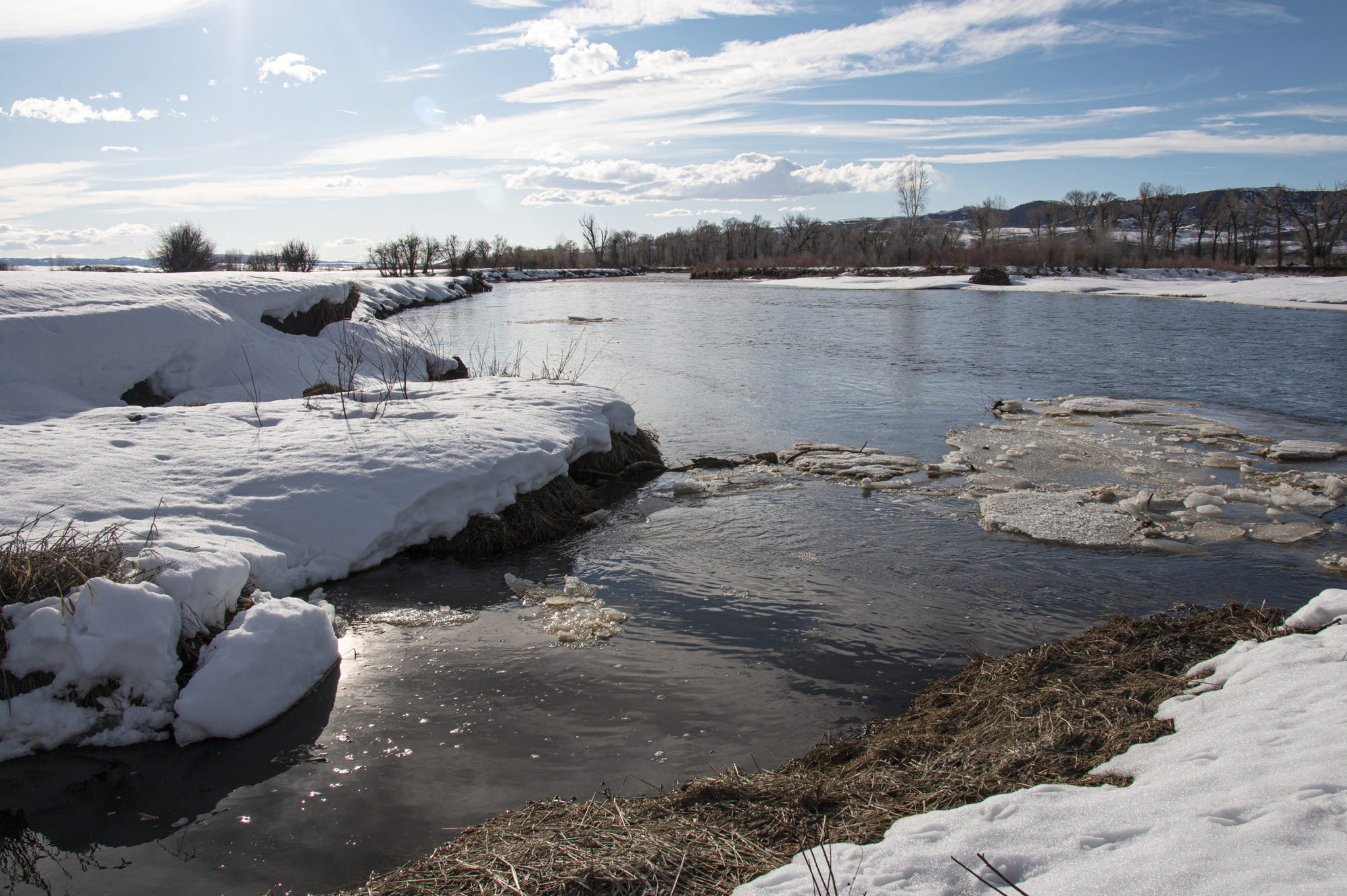
Ice breaks up on the Yampa River as Spring invites warmer temperatures. Should the water that the nearby Hayden and Craig power plants use be allowed to stay in the river once the plants cease to operate, native and endangered fish species in the river would have a higher chance of survival. Photo credit: Bethany Blitz/Aspen Journalism
Endangered species of fish in the Yampa River may benefit as coal-fired power stations close in the next 10 to 15 years.
Water demand in the Yampa River valley has been flat, and only modest population growth is expected in coming decades. Unless new industries emerge, the water will probably be allowed to flow downstream.
And that will be of value in recovering populations of fish species.
The Yampa River downstream from Craig has been designated as critical habitat for four species of fish listed for protection under the Endangered Species Act: Colorado pikeminnow, razorback sucker, bonytail and humpback chub.
The Yampa River can fall to very low levels, especially during late summer in drought years, but the water now consumed by power plants at Craig and Hayden could possibly help augment those flows.
The power plants at Craig and Hayden together use about 10% of the water in the Yampa River basin. Municipalities, including Steamboat Springs, Hayden and Craig, use about 10%, and irrigation accounts for 80% of the use, which is common on Western Slope rivers.
Tri-State Generation and Transmission, the dominant owner of the 1,283-megawatt Craig Station, located just outside of Craig and not far from the Yampa River, will close the first unit in 2025 and unit 3 by the end of 2030.
The retirement date for unit 2 isn’t entirely clear. Tri-State has said 2030, but former Colorado Gov. Bill Ritter, who convened stakeholder discussions last year that led to the shutdown plan, told a congressional committee in late February that unit 2 will be closed by 2026. Tri-State spokesman Mark Stutz said the wholesale provider’s partners still need to agree on a retirement date.
Thermoelectric power generation plants in Moffat County, which includes the Craig plants, used 17,500 acre-feet of water in 2008, according to a 2014 study. Routt County used 2,700 acre-feet.
Xcel Energy, the dominant owner of 441-megawatt Hayden Station, will make its plans more clear in early 2021 when it submits its electric resource plan to the Colorado Public Utilities Commission as it is required to do every four years, said Xcel spokeswoman Michelle Aguayo.
Nobody knows for sure yet how the water will be used once those plants close and remediation is completed. But Eric Kuhn, former general manager of the Colorado River Water Conservation District, expects the water will be allowed to flow downstream. He points out that demand in the Yampa Valley has been flat.
“What will happen with that water being used? Probably nothing,” Kuhn said.
And that could help the endangered fish, which are struggling to survive in a river depleted by humans.
“We have a hard time meeting our flow recommendations, particularly in dry years,” said Tom Chart, program director for the Upper Colorado River Endangered Fish Recovery Program.
“As water becomes more available through the closure of those power plants, we could improve performance in meeting our flow recommendations, and that would certainly benefit the aquatic environment and the endangered fish,” he said.
Tri-State, however, has not divulged plans for future use of water from Craig Station. Tri-State spokesman Stutzsays Tri-State will continue to use the associated water during the decommissioning of its power plants and mines.
Steamboat-based water attorney Tom Sharp sees the water from the power plants mattering most in low-water years, such as 2002, 2012 and 2018.
And in the pinch time of August and early fall, Sharp said, the water from the coal plants could make a difference for endangered fish if the water is left in the river or held in storage for release during low-flow times.
Doug Monger, director of the Upper Yampa Water Conservancy District, shows the abandoned meander of the Yampa River that flows through his ranch, Monger Cattle Company, outside of Hayden, Colo. Monger said he isn’t too concerned about Front Range water diversions in the grand scheme of things. Photo credit: Bethany Blitz/Aspen Journalism
Front Range ‘water grab’?
Diversions by Front Range cities remains a worry by many in Craig, but experts see no cause for fear of a “water grab” by Front Range cities.
“I don’t want to see these water rights sold to the highest bidder on the Front Range,” a woman told the Just Transition workshop in Craig on March 4, provoking sustained applause from many among the more than 200 people in attendance. The state’s Just Transition advisory committee was created by and tasked by the state legislature in House Bill 19-1314 with creating reports, first this July and then December, about how to best assist coal-dependent communities as mines and plants close.
Not to worry, say experts. Geographic barriers between the Yampa Valley and the Front Range that have precluded diversions over the past century remain.
Also, experts point out that rights associated with the power plants are relatively “junior,” in the lexicon of Colorado’s first-in-time, first-in-right doctrine of prior appropriation. The oldest right, from 1967, belongs to the Hayden plant. More valuable by far are water rights that predate the Colorado River Compact of 1922.
“If Front Range entities were inclined to a water grab, they would be looking for something a little more useful, and pre-compact rights are on the ranches,” said John McClow, a water attorney in Gunnison and an alternate commissioner from Colorado on the Upper Colorado River Water Commission.
The compact governs allocations by Colorado and the other six states in the basin, and pre-compact rights will be most valuable in avoiding a compact curtailment, should the Colorado River enter even more extended and deeper drought.
Hayden rancher Doug Monger, a member of the Yampa-White-Green Basin Roundtable and director of the Upper Yampa Water Conservancy District, similarly downplays worries about Front Range diversions.
“I don’t think it will be as much of a threat in the bigger scheme of things,” he said.
Editor’s note: Aspen Journalism is collaborating with the Steamboat Pilot & Today and other Swift Communications newspapers on coverage of rivers in the upper Colorado River basin. This story ran in the April 7 online edition of The Steamboat Pilot & Today.
The Southern Nevada Water Authority, along with contractor Barnard of Nevada, Inc., announced the completion of the Low Lake Level Pumping Station after nearly five years of construction.
The $650 million project at Lake Mead was finished on time and came in under budget, marking a big step in new infrastructure that is critical in preserving reliable water delivery for the valley.
The pumping station holds a capacity to deliver 900 million gallons of water per day to two of SNWA’s treatment facilities…
The station consists of 34 submersible pumps located in shafts that are six feet in diameter. These shafts extend 500 feet to a 12,500-square-foot underground cavern. This cavern, called a forebay, is linked by a tunnel to a third water intake, which is at the 860-foot elevation within Lake Mead…
This intake, which was finished being installed in 2015, ensures that Southern Nevada will still have access to the lake’s precious water supply even if levels drop below the other two intakes located at 1,000- and 1,050-foot elevations.
This protects the community from drought conditions as well as customers from water quality issues related to dropping lake levels.
FromColorado Public Radio (Michael Elizabeth Sakas):
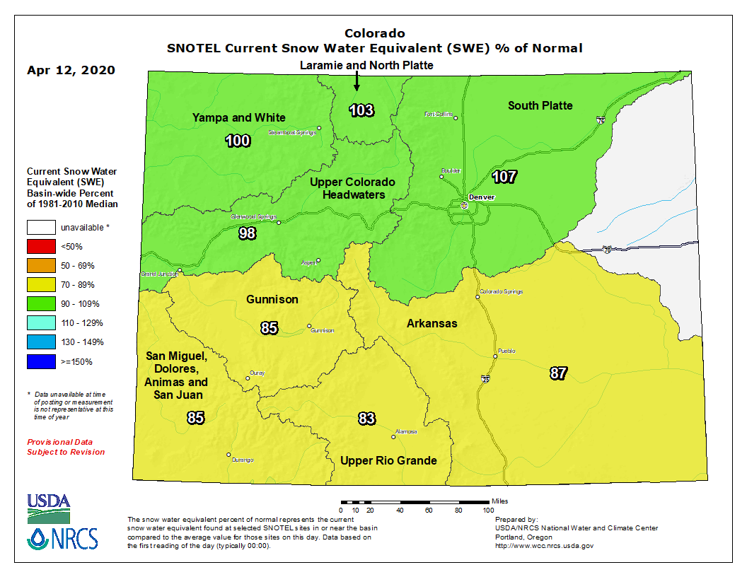
Almost three weeks into spring and Colorado’s snowpack is “in a good spot right now,” said snow survey supervisor Brian Domonkos. Statewide, the snowpack is 102 percent of normal according to data from the Natural Resources Conservation Service.
Domonkos said this is the time of year when snowpack peaks in the southern mountains, which currently sits at about 93 percent of the season-to-date average.
The northern mountains are at 109 percent of normal, where snowpack can continue to accumulate for at least a few more weeks as winter conditions stick around. The Front Range’s South Platte river basin is at 112 percent of normal, the highest of the state’s eight basins.
Colorado snowpack basin-filled map April 12, 2020 via the NRCS.
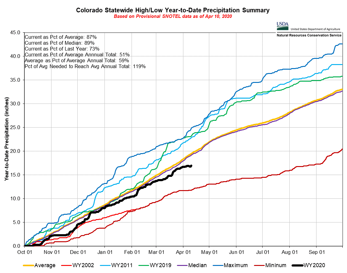
Domonkos said this is good news since the majority of the water Coloradan’s use comes from melting snowpack. Domonkos notes that the statewide precipitation is at 91 percent of the norm…
Water year 2020 precipitation through April 10, 2020 via the NRCS.
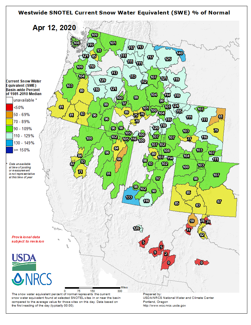
To compensate for the discrepancies, streamflow forecasts are measured. Domonkos said things are more favorable in the northern half of the state, with the South Platte, Yampa White Green, North Platte and the Colorado basin forecast for 95 percent to 110 percent of normal streamflows. In the southern half of the state, the forecast ranges between 65 percent to 95 percent of normal.
Reservoirs are getting ready to collect the runoff, and statewide are 107 percent of average. Domonkos said reservoirs are in a good spot right now, but it’s hard to say where they’ll be in a few months. He might encourage southern reservoir managers to start collecting runoff earlier, where there are lower than normal streamflow forecasts.
Westwide SNOTEL basin-filled map April 12, 2020 via the NRCS.
Tune into the 24th episode of our podcast: We Are Rivers. Learn all about Colorado’s instream flow program, and the significance it has on surrounding rivers and communities.
Join us for Episode 24 of We Are Rivers, as we de-wonk Colorado’s instream flow program, a critical tool to protect and enhance river flows across the state of Colorado.
Rivers form the lifelines of Colorado’s economy and lifestyle. On both sides of the Continental Divide, rivers provide world class fishing, paddling and fantastic scenic canyons. Not only do rivers provide engaging recreation opportunities, they also provide most of Colorado’s clean, safe, reliable drinking water, support our thriving agricultural communities, and substantially contribute to Colorado’s culture, heritage, and economy.
Recognizing the importance of rivers and the fact that the state needed to correlate the demands humans place on rivers with the reasonable preservation of the natural environment, Colorado established its Instream Flow Program in 1973. This program allows the Colorado Water Conservation Board (CWCB) to hold instream flow water rights – a legal mechanism to keep water in a specific reach of a river – to preserve or improve the natural environment of a stream or lake. The CWCB is responsible for the appropriation, acquisition, protection and monitoring of instream flow water rights.
The CWCB is the only entity in the state that can hold an instream flow water right, however many different entities including cities, agriculture, recreation and the environment benefit from instream flow water rights. In this episode of We Are Rivers, we explore the benefits of the program and discuss the important partnerships and collaborations that occur between different water users.
Take for example the City of Steamboat Springs. The 2002 and 2012 droughts significantly reduced flows in the Yampa River, impacting all water users. In 2002, the river experienced some of its lowest flows on record. River sports shops closed their doors, there was a voluntary ban on angling, and farmers and ranchers had less water. The river and the community suffered. Flash forward to 2012, and the community faced similar drought conditions. But partners got creative, and used the instream flow program to bolster flows in the Yampa River, preventing history from repeating itself. This partnership included the CWCB, Colorado Water Trust, and Upper Yampa Water Conservancy District. Together, they temporarily leased water from Stagecoach Reservoir, improving flows in the Yampa through the City of Steamboat. The short-term leases from Stagecoach Reservoir were vital to the health of the Yampa River and its surrounding communities, and were used not only in 2012, but also 2013 and 2017. This is just one example of how a diverse set of partners came together and utilized the instream flow program for many benefits.
The instream flow program underwent an exciting expansion earlier this year that will provide more opportunities for communities to benefit from collaborative instream flow solutions. After a multi-year stakeholder effort, the Colorado Legislature passed a bill to expand Colorado’s existing instream flow loan program – HB20-1157. The law expands protection of rivers without threatening or hindering existing water rights. It authorizes a targeted expansion of the loan program that makes the program more useful to water right owners and benefits Colorado’s rivers and streams. Specifically, it adjusts the amount of time a user can exercise a renewable loan from 3 years out of 10, to 5 years out of 10 years and it allows water right owners to renew participation in the program for up to two additional 10-year periods, for a total of 30 years. This is a huge opportunity for rivers and communities: take, for example, the benefit this provides to the Yampa River. The partners working together to secure the 3 in 10 instream flow loan on the Yampa through the city of Steamboat Springs now have two additional years in this 10-year period where water can be leased under the expanded program. Future climate conditions make frequent droughts more likely, and the opportunity to curb impacts during those back-to-back drought years is another important and timely benefit of the expanded ISF program.
The complexity of Colorado Water Law is a lot to digest, and the instream flow program is no exception. We hope you join us for Episode 24 to break down the specifics of the instream flow program and what it means for rivers and communities. Take a listen today!
Bicycling the Colorado National Monument, Grand Valley in the distance via Colorado.comHere’s a guest column from Jim Pokrandt that’s running in The Grand Junction Daily Sentinel:
April is a good time to celebrate the Grand Valley’s relationship with the Colorado River. The great canals and laterals of the valley’s turn-of-the-last-century irrigation infrastructure are filling with water, an annual rite of spring. Irrigation season is upon us and that matters to every soul in the valley.
Water makes the Grand Valley grand. It makes it green. It makes the desert livable. It makes the economy go ’round.
Look north of the Government-Highline Canal and what do you see: a dry, scrub landscape. It’s beautiful in its own right, good for livestock grazing and in today’s world, an attraction for mountain bikes and dirt bikes.
The Grand Valley would look like the desert it really is but for three things: the good soils, a long growing season and the introduction of irrigation water, the ultimate catalyst that makes the formula work for agriculture and our urban landscapes.
More than that, it matters to folks from the headwaters counties along the Continental Divide all the way down the mainstem of the river to the Grand Valley. And it’s not because everybody loves a Palisade peach or a bottle of Grand Valley-produced wine, although they should. It’s not because people like me prize the unsung, delicious tomatoes grown in the valley or the locally produced beef that finds its way into restaurants.
Here’s why: the very senior water rights held by the irrigation companies command the river, controlling the natural east-to-west flow of water. That natural direction of water could otherwise be intercepted by big tunnels through the Continental Divide that move water to eastern Colorado. Some 500,000 acre-feet already go to the east, and it has defined the Front Range as we know it with vibrant cities, universities, culture, agriculture (the primary reason water was first moved) and an economy that benefits us all. Use it well, we say here in western Colorado. But if you want more, that’s a problem. That is a story, though, for another time.
Grand Valley folks are water savvy, in my experience. They understand the role their water rights play in the well-being of western Colorado. Likewise, the headwaters counties of Grand, Summit, Eagle, Pitkin and Garfield know the value of your Grand Valley water rights. Your irrigation rights pull water downstream and that underpins the economies, the environment and recreation in each of these upstream locales. They don’t want your water. They want you to maintain a thriving water rights system so their communities can thrive, too.
Water travels through a roller dam, generating power, then continues downstream. Roller Dam near Palisade. Photo credit: Hutchinson Water Center
The linchpin of the Grand Valley water rights system is the Roller Dam in De Beque Canyon, just upstream from where Plateau Creek enters the mainstem of the Colorado River. It is more than 100 years old. It diverts water for the Grand Valley Water Users Association, the Orchard Mesa Irrigation District, the Palisade Irrigation District and the Mesa County Irrigation District. It’s not just about agriculture anymore. Many residential homes receive raw irrigation water from this infrastructure. Valley residents should know that the Grand Valley Water Users Association, operators of the Roller Dam, is working its way through a master plan to keep it in repair. It’s not inexpensive work.
The Grand Valley Irrigation Company is the last canal to divert. Its infrastructure is at Palisade. It, too, is working to maintain and improve its system. This month it finished the latest canal-lining segment. In fact, it has lined 10.63 miles in the last 11 years at a cost of about $14 million. This work is part of a long-running effort across the valley to keep salts out of the river.
Green Mountain Reservoir, on the Blue River between Kremmling and and Silverthorne, was built for Western Slope interests. Photo/Northern Colorado Water Conservancy District via The Mountain Town News.
One of the most important pieces of the Grand Valley’s water mosaic is located many miles away in Summit County. It’s Green Mountain Reservoir. Green Mountain stores water that comes into play for the Grand Valley and other users as snowmelt winds down through summer and streamflows diminish, part of the natural cycle. Releases are then stepped up to bolster river flows.
Green Mountain was negotiated as a western Colorado benefit back in the 1930s when the big transmountain diversion, the Colorado-Big Thompson Project, was proposed to take Colorado River water out of Grand County and send it to northern Colorado. That raised alarms in Mesa County and all along the river. The negotiators became the founders of the Colorado River District in 1937, so there could be a taxpayer-supported entity to watchdog regional water interests as the Front Range grew. Some of those founders were from Mesa County. Yes, back then, folks realized the importance of water supply and river flows to the Grand Valley.
Shoshone Hydroelectric Plant back in the days before I-70 via Aspen Journalism
Not to be overlooked in this ode to the Colorado River is the importance of the Shoshone Hydro Plant in Glenwood Canyon. It also commands the river, not just in the irrigation season, but in all 12 months. The Daily Sentinel recently reported on how reservoir operators and Grand Valley irrigation entities cooperate to mimic Shoshone water rights in the river when the plan is down and cannot call for water. The benefits of Shoshone, whether its operating or its flows are mimicked, are the same generated by the Grand Valley water rights. Plus, they improve the environment for endangered fish.
So, while we cope with orders to stay at home in order to avoid getting or spreading the coronavirus and wonder how we can restart the economy, we can take solace in the bedrock fact that water is flowing in the Grand Valley and springtime will soon be in full bloom.
Palisade peach orchard
Jim Pokrandt is the community affairs director for the Colorado River District. Mesa County is one of his favorite places in western Colorado.