Click here to read the current assessment. Click here to go to the NIDIS website hosted by the Colorado Climate Center. Here’s the summary:
Summary: May 12, 2020
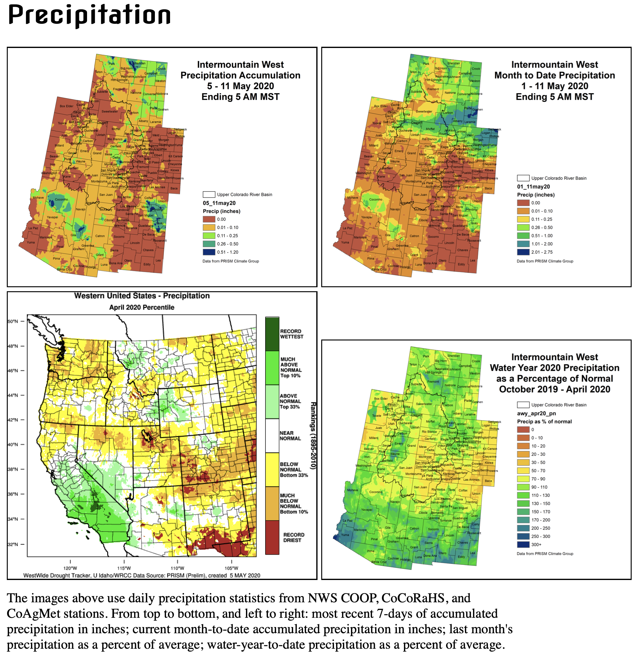
Dryness prevailed through most of the Intermountain West region in April. Much of western and southern Colorado saw the driest or one of the driest Aprils on record. Northern Utah also got in on the extreme dryness that was April 2020 with the Salt Lake area seeing some of their lowest April precipitation amounts on record. For both Utah and Colorado, this was an inopportune time to see this much dryness since April is still a wetter month of the year. Continuing with the dry theme of the week, eastern Colorado started off the growing season with much below normal precipitation. Some wetter spots in the IMW region included north-central Colorado, northwestern Wyoming, and parts of Arizona and New Mexico, see normal or above-normal precipitation.
The second week of May has seen the dry pattern continue with the exception of northern Wyoming, central Arizona and northeastern New Mexico, all seeing about 0.51-1.20” of precipitation. The rest of the IMW saw little to no precipitation.
Typically by this time of year the snowpack season is in full snowmelt form with the occasional May storm that brings a pause to melt and a small increase in the snowpack. This means we have passed the peak snowpack of the year. Most of the IMW saw near normal peaks, with many on the lower end of normal. With little snow in April and a quick warmup, the snowpack is melting quickly.
The quick snowmelt means streamflows are starting to come up. Most of the streams with above normal flows means the snow is melting quicker and earlier than normal. We are seeing above normal flows in the headwaters of the Colorado River and the Yampa River. However, we are also seeing below normal flows on the White, Colorado, Gunnison, San Miguel, and San Juan Rivers. Our three main sites are barely in the normal flow range.
The IMW saw a split in temperatures over the second week of May. Utah, Arizona, New Mexico and western Colorado saw above average temperatures with the highest temps in southwestern Arizona where they experienced 10-15 degrees above normal. Eastern Colorado and Wyoming, on the other had, experienced below average temperatures this last week with the coolest temperatures of 9-12 degrees below average seen in northeastern Wyoming.
Little to no precipitation is forecast to occur over the next week for Colorado, Arizona and New Mexico. The regions with the highest probability of precipitation is northern Wyoming and Utah. The 8-14 day outlook is showing below average temperatures for much of the region except eastern Wyoming and Colorado with a decent chance of precipitation for northern Wyoming and northeastern Colorado with Utah, Arizona and New Mexico being dry.
Click on a thumbnail graphic to view a gallery of drought data from the US Drought Monitor.
US Drought Monitor May 12, 2020.
West Drought Monitor May 12, 2020.
Colorado Drought Monitor May 12, 2020.
Click here to go to the US Drought Monitor website. Here’s an excerpt:
This Week’s Drought Summary
Light precipitation at best covered most of the 48 states, so drought deterioration was more common than improvement this past week. Less than half an inch fell on most areas across the Southeast, Great Lakes Region, central and northern Plains, Mississippi Valley, Texas, and from the Rockies to the Pacific Coast. Widespread light to moderate precipitation covered the Northeast and the central Appalachians, and a fairly broad area centered along the Ohio Valley received from a few tenths to one-half inch. Farther west, there were a few exceptions to the generally dry week. More than 2 inches of rain soaked parts of the south-central Great Plains and adjacent western Mississippi Valley, western Deep South Texas, and central Montana. The broadest area of heavy precipitation covered a solid swath from south-central Kansas through southern Missouri, where totals ranged from 2 to nearly 4 inches. Similar amounts were more scattered in a stripe from southern Oklahoma and northeastern Texas through southern Louisiana, as well as in central Montana. Isolated sites in southwestern Texas were soaked by as much as 6 inches of rain, but closer to 2 inches fell on most locales there. Elsewhere, there were a few areas of moderate to precipitation from the northern High Plains into central Montana, and in orographically-favored parts of the northern Cascades…
Drought is intensifying quickly across the southern tier of this region from southern Colorado through western Kansas. Severe D2 drought is now extant throughout this area, and extreme D3 drought envelops much of southern Colorado and adjacent southwestern Kansas. Most of this region has recorded less than an inch of precipitation during the past 3 months, and at best a few tenths of an inch have fallen mid-March. Abnormally warm weather is exacerbating the acute dryness. The past 3 months have averaged 2 to 4 degrees F above normal, and since late April, averages have been 7 to 9 degrees F above normal. Farther north and east, many areas fell into abnormal dryness this past week as precipitation deficits continued to slowly accumulate. Many areas have seen precipitation totals among the driest 5 percent of historical occurrences for the last 30 days, or 90 days, or both. D0 was introduced where the dryness has been most acute for 1 to 3 months, specifically southeastern Nebraska, a swath from southwest to north-central Iowa, part of eastern South Dakota, southeastern Minnesota, and a large area across central and northern Minnesota. Precipitation has been sharply below normal for at least a few weeks, but impacts have been limited so far. Water supplies, agriculture, and soil moisture have been minimally affected, so the assessment is less intense than most precipitation statistics would imply. At some point, conditions could deteriorate rapidly if these trends continue, so this region must be monitored closely as we move into the growing season.
Farther west, northwest South Dakota and surrounds was one of very few areas to improve this past week, along with part of north-central North Dakota. Generally 2 to 4 inches of precipitations moistened up these regions in the last 2 weeks, eliminating D0 in northwestern South Dakota and adjacent areas.
Precipitation has not been as generous across northern Wyoming, with D0 stretching into northeastern parts of the state, and adjacent Montana. Precipitation among the driest 10% on record was observed in the new D0 areas over the last 4 months. On the other end of the state, abnormal dryness was also introduced in southwestern Wyoming adjacent to Utah…
Central Montana was another of the few areas that improved this week, with 1.5 to 3.0 inches of precipitation bringing relief from recent dryness. Other parts of the state missed the beneficial moisture, and precipitation totals among the lowest 5 to 20 percent on record since early February in southwest Montana, prompting D0 expansion into the region. Farther south and west, dryness and warmth led to deterioration in much of Nevada, Oregon, small parts of Washington, and the western Idaho Panhandle. Most notably, extreme dryness stretched southward in central Nevada, moderate drought enveloped much of northwestern Nevada and adjacent Oregon, moderate drought covered the central Sierra Nevada, and extreme D3 drought expanded in north-central Oregon with a general 1-category deterioration introduced farther east. There were some spots where drought eased – significantly, D3 was improved to D2 in north-central California – but the dry and warm week led to much larger areas of intensification. Snowmelt continued at a rapid pace as temperatures in many areas across the West averaged 2 to 5 degrees F above normal for the past 3 months, and 5 to 10 degrees F for the past 2 weeks…
Similar to conditions in the Southeast, surplus rainfall has prevailed across the interior, but dryness and drought are entrenched along most of the Gulf Coast, and across southern Texas. Less extreme dryness covers part of central Texas, western Oklahoma and adjacent Texas, and the lower Big Bend. D0 prevails across these regions, with only scattered patches of moderate drought. In contrast, extreme D3 drought has developed in a few regions across southern Texas, primarily near the Gulf of Mexico and along the Rio Grande, while severe drought is impacting a large part of southeastern Texas and smaller areas near the Mexican Border. A small area of intense rainfall – up to 5 inches in spots – brought relief to western Deep South Texas, with the wettest areas improving from severe D2 drought to abnormal dryness (D0). Areas of severe to extreme drought recorded less than half of normal rainfall for the past 90 days, with rainfall deficits of 5 to 7 inches observed southeast of Victoria…
Looking Ahead
During May 14-18, 2020 a broad swath of heavy rain is expected from south Texas northeastward across Missouri, the northern Ohio Valley, the Northeast, and lower New England. Forecasts show a broad, unbroken stripe through this region where more than 1.75 inches of precipitation is expected. Within this stripe, some areas are expecting very heavy precipitation. Most notably, central to south Texas is expecting 3 to locally 5 inches of rain. A few smaller patches are expected to get 3 to maybe 4 inches of rain, including northeast Oklahoma and southeast Kansas, part of north-central Illinois, and northwestern Pennsylvania and adjacent Ohio to near Cleveland. Outside this stripe, precipitation will drop off dramatically. From the Carolinas through Alabama and into central Florida, almost no rain is anticipated. Likewise, precipitation should be lacking from the Great Basin and southern California through most of the Four Corners States. Elsewhere, moderate to heavy precipitation is expected in orographically-favored areas near the Sierra Nevada and Cascades, and in south Florida (especially along the southeastern coastline). Light to moderate precipitation, with totals approaching an inch in a few patches, are expected from the upper Mississippi through the north half of the High Plains to the Pacific Northwest. Most of the 48 states will stay warmer than normal at night, save for upper New England. But temperatures should remain unusually low during the day across the Great Lakes into the northern Plains, and from central California through the Pacific Northwest. Other areas should average a few degrees above normal at night, and near normal during the day.
For the ensuing 5 days, drier than normal conditions are favored from roughly from the Mississippi Valley through the Atlantic Seaboard, and to a lesser extent in parts of the central Rockies and surrounds. There are enhanced chances for surplus precipitation across most of Texas into central New Nexico, across the northern tier of states from the Plains westward, and over the Great Basin and nearby California. Meanwhile, in most locales from the Plains (outside south Texas) eastward across the Mississippi Valley to the Appalachians, odds favor above-normal temperatures. Farther west, subnormal temperatures are favored from the western Rockies to the Pacific Coast.
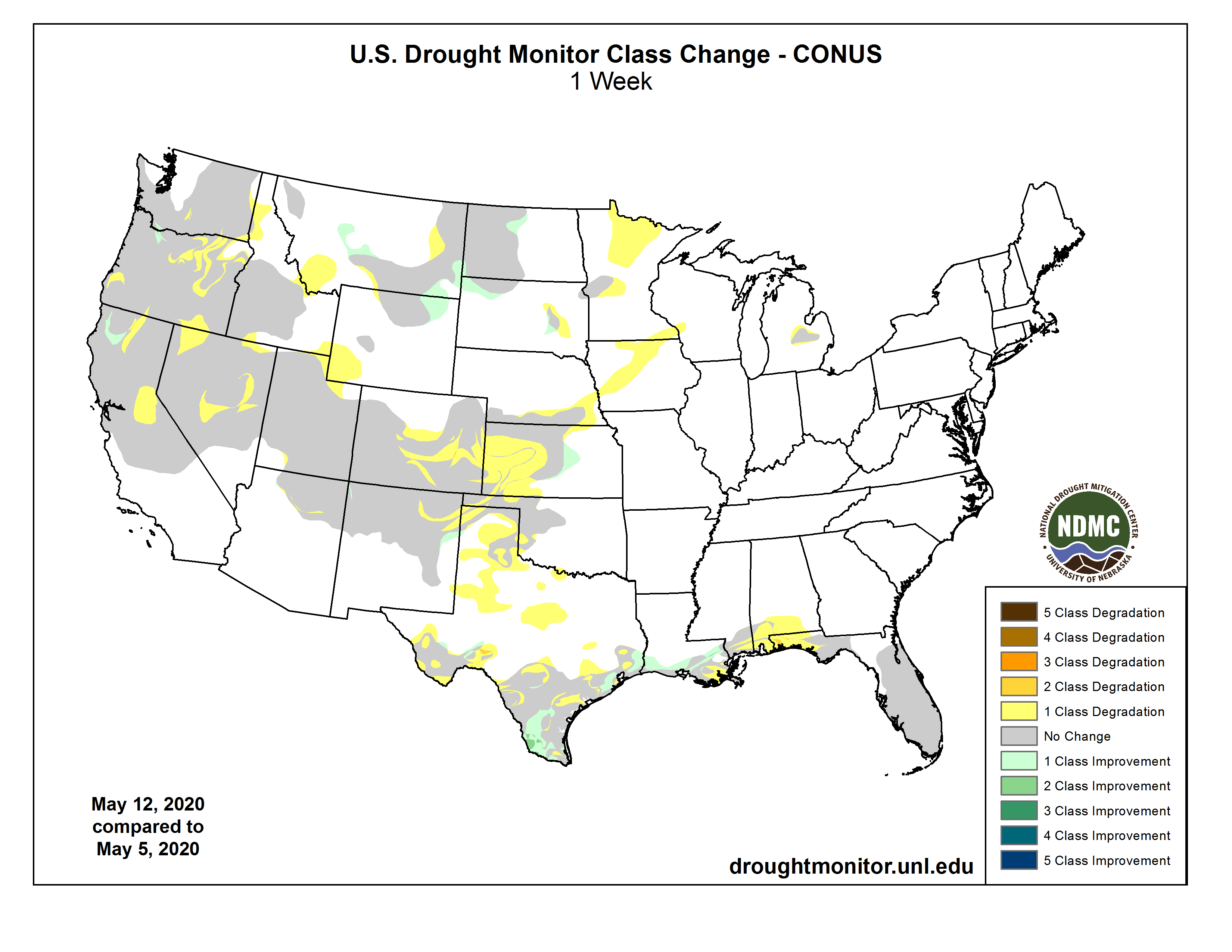
US Drought Monitor one week change map ending May 12, 2020.
It’s important to know about hailstorms so you can avoid injury and stay safe during one: 1. Hail is a form of precipitation — like rain or snow — that is made up of solid ice.
Hail Wheat Ridge May 8, 2015. Photo credit TreeRootCO.
2. It is not the same thing as frozen rain.
Frozen rain falls as water but freezes as it gets near the ground.
Hail falls as a solid, known as hailstone.
3. Hailstones are formed when rain droplets are carried upwards by a current of air, called an updraft, during thunderstorms.
“Hail forms as robust thunderstorms grow taller and taller, lofting moisture up into the atmosphere where it freezes,” explains Jonathan Belles, digital meteorologist at Weather.com.
4. “The stronger the thunderstorm, the larger the hail can get,” says Belles.
That’s because hailstones grow in size as the frozen moisture droplets collide with surrounding water vapor, causing that water to freeze on the hailstone’s surface in layers.
A frozen droplet will start to fall back towards earth from a storm cloud, then be pushed back up into the cloud by an updraft, hitting rain droplets — which freeze on its surface — as it moves.
Winds inside a thunderstorm aren’t just up and down, though, especially in severe storms. There are horizontal winds, such as rotating updrafts in supercell thunderstorms, which can move the hailstone too and affect how it grows.
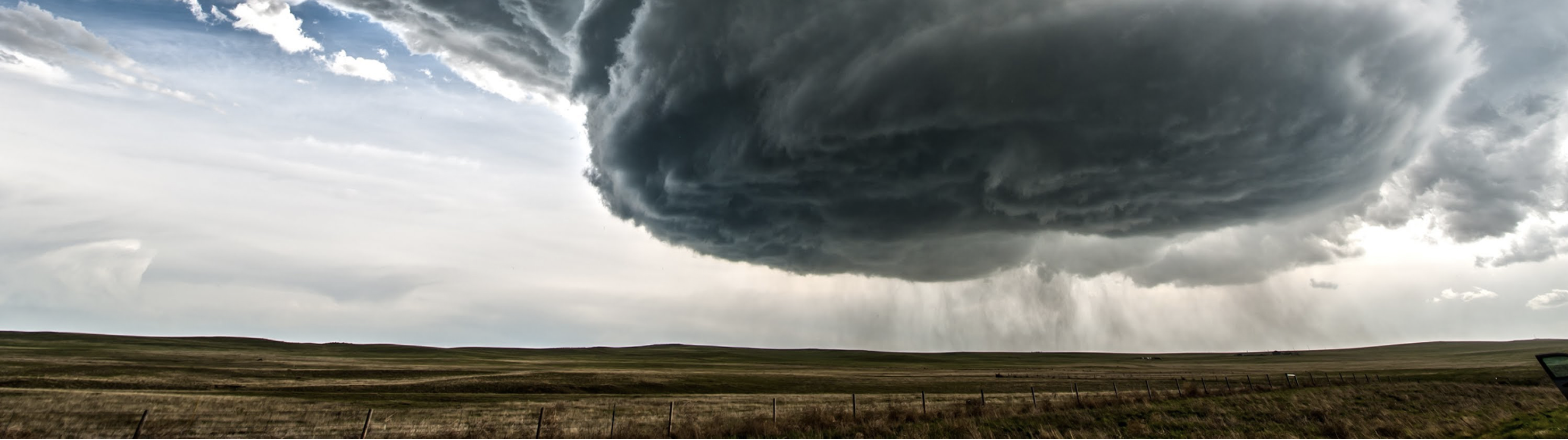
Students in Sam Ng’s Field Observation of Severe Weather class hit the road every spring to observe storm structures, like this mesocyclone in Imperial, Nebraska. Photo by Sam Ng via Metropolitan State University of Denver
Eventually, the hail does fall to the ground. This happens, Belles explains, “when updrafts can no longer support the weight of the hailstones.”
5. Hailstones can be clear or cloudy.
It all depends on how the hailstone forms: If the hailstone collides with water droplets and they freeze instantaneously, cloudy ice will form because air bubbles will be trapped inside it.
If the water freezes more slowly, air bubbles will be able to escape and the ice will be clearer.
They can also have layers of clear and cloudy ice as the hailstone experiences different conditions in the thunderstorm.
6. Hail size is often estimated by comparing it to a known object.
For example, hail that is ¼ inch in diameter is referred to as pea-size, hail that is 1-inch in diameter is called a quarter-size, and hail that is 4 inches in diameter is softball-size.
“Most hailstones are small, generally pea size,” says Belles. “The National Weather Service considers hail dangerous to life and property when the stones reach about the size of quarters. We typically see hail up to softball size several times a year.”
It’s worth noting, however, that most hailstorms are made up of a mix of different sizes.
7. The largest hailstone ever recovered in the United States was 8 inches in diameter and had a circumference of 18.62 inches.
According to the National Severe Storms Laboratory (NSSL), it weighed 1lb. 15 oz. and it fell in Vivian, South Dakota [do you have a date for when this happened? Might be good for reference].
8. The speed that hail falls depends on a lot of things.
The speed depends on the size of the hailstone, the friction between the hailstone and surrounding air, the local wind conditions and whether or not the hailstone starts to melt.
According to NSSL, small hailstones under an inch usually fall at speeds between 9 and 25mph, whereas hailstones of an inch to 1.75-inches in diameter typically fall faster — between 25-40mph. The strongest supercells, which can produce hail between 2 and 4 inches in diameter, can cause hail to fall at speeds of 44-72mph.
9. Hail storms can happen all year long.
“Hail can form at any time of the year as long as the thunderstorms are strong enough,” explains Belles. “While the biggest hail is often associated with severe thunderstorms in the Plains and Southeast from February to June or July, hail is also common in the cooler season along the West Coast as storm systems take advantage of the winter cold air.”
From 2009-2018, May and June averaged nearly 3000 reports of severe hail, which the National Weather Service classifies as being one inch or larger in diameter.
10. Some regions do get more hailstorms than others — and it’s not necessarily the regions that get the most thunderstorms.
Florida is a very thunderstorm-prone state, but it’s not actually the place where hail storms are most common.
“Hail is most likely from the Dakotas to Texas during the course of the year,” explains Belles. “This is the location where the strongest thunderstorms overlap with cold air aloft and fast winds in the jet stream.”
The area where Nebraska, Colorado and Wyoming meet is known as “hail alley” and it averages seven to nine hail days per year, according to NSSL. Colorado experiences the greatest damage from hail storms, followed by Texas, Illinois, Minnesota and Missouri, according to the Insurance Information Institute.
Abroad, China, Russia, India and northern Italy get frequent hail storms too.
11. Hail falls in paths called “hail swaths.”
These can be seen from the airplanes and they occur as thunderstorms move while the hail falls.
According to NSSL, hail swaths can range in size from just a few acres to an area 10 miles wide and 100 miles long.
12. Hail storms can cause significant damage.
Hailstones can cause a lot of damage to buildings, vehicles, crops and livestock.
In fact, hail causes approximately $1 billion in property and crop damage every year in the United States. One of the costliest hail storms in the country hit Denver, Colorado in July 1990 and caused $625 million in damage. A 2016 study by the Highway Loss Data Institute found that insurance companies paid $5.37 billion in total hail claims to automotive policy holders.
While quarter-size hail will cause damage to shingles, golf ball-size hail can cause dents on cars and baseball-sized hail can smash windshields. Softball sized hail, meanwhile, can cause holes in roofs.
While reported human deaths from being struck by hail are somewhat rare in North America, they do happen. In 2000 a man in Fort Worth, Texas was killed when he was struck by softball-sized hailstone.
Hail storms can also cause severe injuries. On average, an estimated 24 people are injured by large hail each year, but sometimes, there can be a lot of injuries from one storm. For example, a May 1995 hailstorm in Texas injured 400 people when they were caught outside during Mayfest with very little shelter available; 60 of those injured required hospitalization.
Even hail storms that produce a lot of small hail can be dangerous because all those hailstones can completely cover roads. If these hail piles are deep enough, they can prevent car tires from touching the road at all. This makes driving conditions similar to icy winters.
13. It’s tough to forecast when a hailstorm might occur in advance.
“We usually have a few days heads up that conditions might be ripe for hail, but we don’t know that any community will have hail until an hour or so before it occurs,” says Belles.
14. The best way to protect yourself from a hailstorm is to be prepared, especially if you live in a hail-prone region.
“We all should have our storm kits well-stocked throughout the year,” says Belles, and those storm kits should include helmets. “[They] can help you save your head from both the hail itself and the debris that can also come with severe thunderstorms.”
It’s also a good idea to make a disaster preparedness plan for your family so that you all know where to go for safety and how to contact each other after an emergency.
If severe weather occurs, such as a bad thunderstorm, tune in to the radio or another news source to make sure you stay up to date of any immediate threats to your family or property.
15. If you get caught outside in a hail storm, seek shelter indoors.
Make sure you stay inside until the hail stops and stay away from skylights and windows. Close the drapes or curtains if you have them to keep broken glass and hailstones out of your home. It’s also best to seek shelter at least one level down from the roof.
If you’re driving, pull over as soon as possible, preferably by near a place with shelter, like a garage or under a gas station awning. Make sure you’re completely off of the highway.
“If you’re caught in a hail storm in your car with no sturdy structures nearby, please stay in your car and cover yourself if possible,” Belles says. “While windows may break, the car should keep your head safe.”
If you’re outside and you can’t find shelter, find something to at least protect your head and stay out of ditches or lowland areas because they could fill with water. Avoid trees because they can lose branches during thunderstorms and isolated trees can also attract lightning.
Here’s the release from the Colorado Water Conservation Board:
After more than three decades of collaboration between federal and state entities and local water providers, Chatfield Reservoir will begin storing up to an additional 20,600 acre-feet of water this spring.
The Chatfield Reservoir Reallocation Project (Project), which recently received final approval from the U.S. Army Corps of Engineers, is an effort to help meet Colorado’s water supply and demand gap. The Project brings environmental, agricultural, and outdoor recreational benefits along with new, critical multi-purpose water storage capacity for growing front range communities including Highlands Ranch, Castle Rock, and Castle Pines.
“This Project addresses the critical need for reallocating storage space to meet our water supply and demand gap in Colorado while providing important wildlife habitat and increasing South Platte River flows through the Denver metro area,” said Colorado Department of Natural Resources Executive Director Dan Gibbs. “The Chatfield Reservoir Reallocation Project is a prime example of federal, state, and local collaboration and would not have been possible without the support of Colorado’s Congressional delegation, Douglas County, water providers, and members of the nonprofit community bringing this important storage project to the finish line.”
The Project involved rebuilding portions of Chatfield State Park to accommodate the increased water levels and completing a number of projects aimed at improving wildlife and aquatic habitat. Two properties in Douglas County outside of Chatfield State Park will also be preserved to compensate for bird habitat impacted by the Project.
U.S. Army Corps of Engineers Omaha District Commander, Col. John Hudson said, “This project is a great example of federal, state and local authorities working together to address vital water supply issues along the Front Range. The higher authorized lake level will provide greater water storage and increased recreational opportunity for the residents of Douglas County and the State of Colorado. It’s very rewarding having the opportunity to be part of such a great project.”
Modifications to state park amenities include the floating marina, boat ramps, the swim beach, bike trails, parking lots, tree thinning, and forest floor clean up on walking trails. Onsite environmental mitigation included restoring Plum Creek and the South Platte, two of the reservoir’s primary tributaries, to control erosion and improve habitat. The Project also includes a dedicated “environmental pool” which will provide stream flow through the metro reach of the South Platte, during historically drier times of the year.
“Not only will the environmental pool improve recreational and water quality downstream of Chatfield, but the releases will also be utilized for irrigation of family farms and livestock operations in the South Platte valley, which are vital to Colorado’s economy,” said Randy Ray, Chatfield Reservoir Mitigation Company Board President and Executive Director of Central Colorado Water Conservancy District.
Totaling $171 million, this Project was funded by the water providers and the State of Colorado with a significant portion financed through the Colorado Water Conservation Board’s (CWCB) loan program. Colorado’s bipartisan Congressional delegation has long supported the project and worked to secure Federal funding and project approvals.
Court rulings and public votes since then have weakened TABOR. But it still has teeth, and could significantly affect how quickly governments rebound. It could also provide relief for taxpayers, just as they need it the most.
TABOR’s author Douglas Bruce designed it to limit how quickly governments can grow.
He came up with a formula. The state government’s general fund is allowed to grow only as quickly as population and inflation. Local governments’ revenue is tied to inflation plus construction value, and school districts are limited by student enrollment. Any revenue beyond that limit is returned to voters.
Governments are only allowed to keep that revenue if they get voters’ permission — a process called, oddly enough, “de-Brucing.” Many local governments have done that. According to the progressive-leaning Bell Policy Center, voters in 174 out of 178 school districts, 51 out of 64 counties, and hundreds of cities have granted their respective governments the ability to keep all or some of the excess revenue.
Whether or not a government has de-Bruced will be very important in the months and years ahead. For de-Bruced governments, tax revenues can rise as the economy picks back up. But that’s not true elsewhere.
Like many governments, Jefferson County is looking at making deep cuts to services like snow removal, its workforce center, and its county jail. County staff just moved to a four-day work week as well.
But Jefferson County is different in one respect, said county commissioner Casey Tighe. Because most of its budget has not been de-Bruced, those cuts could be permanent even after the economy recovers. Unless voters approve a de-Brucing measure (and they shot one down last year), TABOR will prevent the county’s revenues from rising quickly back to pre-recession levels. Instead, the “ratchet effect” dictates that revenues can only be slightly higher than the previous years’ recession-era levels. Anything beyond that will be returned to taxpayers…
The state of Colorado was in a similar position in the early- to mid-2000s, when the dot-com bust exposed TABOR’s ratchet effect in a major way. At the time, the state was in such a budget bind that it considered closing some colleges even as the economy was kicking back into gear.
So then-Gov. Bill Owens, a Republican, led a campaign to weaken TABOR. Voters passed Referendum C, which while not a true de-Brucing, effectively destroyed the ratchet effect at the state level. (Read a rather thorough explanation of Ref C here). The state still has revenue limits, but they’re now so much higher than the state’s actual revenue that Gov. Jared Polis recently wrote that TABOR “isn’t really top of mind” right now.
Jefferson County won’t get a clear picture of its shortfall until some next year, Tighe said. That’s because counties largely rely on property taxes, which are paid well in advance. They’re also less volatile than sales taxes, which cities generally collect.
But TABOR also has a big effect on property taxes in particular.
Prior to TABOR, there was the Gallagher Amendment. Voters passed in 1982 as a way to keep residential property taxes low. It mandates that residential properties pay 45 percent of overall property taxes in Colorado, while commercial properties pay 55 percent.
As residential property values go up and commercial values go down, the residential assessment rate — the percentage of a home’s value that is subject to taxation — is lowered to keep the 45/55 split intact. And once the assessment rate goes down, TABOR prevents it from coming back up without voter approval.
That was by design, TABOR author Douglas Bruce told CPR News in 2017. “I knew what I was doing, and I don’t regret anything that’s in there,” he said.
The residential assessment rate is projected to drop by nearly 18 percent to 5.88 percent, the Colorado Sun reported Tuesday. That could mean a $491 million hit to school districts and a $201 million hit to counties across the state, according to a state forecast.
Since Gallagher is a constitutional amendment, voters would need to approve any changes to it. And convincing homeowners to raise their own taxes now would be an uphill battle, said Gini Pingenot, legislative director at Colorado Counties, Inc…
But as it stands, non-residential property owners such as farmers, ranchers and small businesses will be paying close to six times more in property tax than homeowners.
“That is a result of TABOR,” said Tracie Rainey, executive director of the Colorado School Finance Project.
The drop in local tax revenue will also put pressure on the state government, because it is obligated to backfill school district funding shortages. That could amount to $250 million in 2021, Rainey said.
TABOR also limits legislators’ ability to adjust tax policy — except to lower it — without voter approval, she noted. It does have a provision to allow for new emergency taxes without voter approval (and after reserves are spent), but that requires a two-thirds majority in both chambers — an unlikely scenario, the Denver Post reported. On top of that, Polis said earlier this month that he wouldn’t support any tax hikes given the current economic climate…
There’s one more way TABOR could affect schools’ recovery, Rainey said. The state government has withheld billions of dollars from schools since the Great Recession (a budget maneuver once called the “negative factor”). In the future, whenever the state hits its revenue cap again, TABOR may require the state to issue tax refunds rather than pay that back.
But wait! Doesn’t TABOR help recession-era governments somehow?
TABOR proponents say that it prevents governments from growing too bloated in flush years, which prevents drastic cuts in tough times.
“Government programs are more sound, strong and sustainable than if they had grown as fast as ambitious politicians often wanted,” Peg Brady, a TABOR backer, wrote in a Denver Post op-ed last week. “TABOR helps us confront the current crises.”
Critics of TABOR instead point to Colorado’s billions of dollars in unfunded transportation projects and withheld funds for schools.
TABOR also has a requirement that every government save 3 percent of its annual budget for use only during a declared emergency. Polis declared a state of emergency in early March and recently extended it until June. But that money can only be used for expenses directly associated with the emergency, said David Broadwell, general counsel for the Colorado Municipal League.
“But you can’t tap your emergency reserve just to make up for revenue shortfalls, which is the major crisis facing a typical municipality today,” he said.
Denver is the only city that’s used its TABOR reserves, Broadwell said.