Here’s an in-depth look at the opening of national parks from Krista Langlois that’s running in National Geographic. Click through for all the photos and graphics. Here’s an excerpt:
Despite these concerns—and questions of whether it’s premature to open parks at all—the Park Service is doing some things right. Rocky Mountain National Park is implementing a “timed entry” system to spread out crowds by giving people a specific time slot when they’re allowed to enter the park. Other parks may follow suit.
Yosemite, which plans to reopen in June, is among a number of parks limiting visitors to roughly half its typical capacity. Yellowstone has spent $135,000 on sanitation, protective gear, and educational signs. The Park Service is distributing masks and gloves to employees, albeit unevenly, and trying to educate visitors on safe practices: staying six feet apart, choosing parks close to home, and avoiding traveling long distances to get to a park.
(Related: Trespassing and vandalism abound at national parks that remain open during the pandemic.)
Some parks, like Yosemite, remain closed, while others were relatively quiet over Memorial Day weekend. A visitor from Big Cypress National Preserve in Florida said the park was practically empty, perhaps because of rain. A hiker in Washington’s Olympic National Park, where many roads remained closed, reported seeing few crowds. A ranger at Virginia’s George Washington Memorial Parkway, which connects trails around Washington, D.C. and is administered by the Park Service, said that the people he saw hiking were mostly in small groups spaced well apart.
Still, some parks just aren’t set up for social distancing. It’s nearly impossible to stay six feet apart on the boardwalks around Yellowstone’s geysers, for example, or the narrow hiking trails in Zion. That means that the responsibility to stay safe falls both to parks and individual travelers. “It’s really important for visitors to go online and check the park’s website before they go so they can make sure they’re prepared,” Brengel said. “If a park is going to be too crowded or a trail is closed, they should have a plan B.”
Having a backup plan—such as visiting a less-busy national forest—is one of the recommendations of the new #RecreateResponsibly initiative, a collaboration between nonprofits, outdoor businesses, and land managers. Other recommendations include adventuring with members of your household; choosing low-risk activities to decrease the chances of needing already-strained emergency services, such as hiking instead of rock climbing; and being self-sufficient, such as packing your own lunch instead of counting on a park restaurant to be open. The #RecreateResponsibly initiative emphasizes staying close to home, because non-essential travel is still discouraged by the nation’s top health officials.
Gold is everywhere in modern life, from jewelry to electronics to smartphones. The global electronics industry alone uses 280 tons annually. And that demand keeps growing.
But most people know little about the environmental impacts of gold mining. About 15% of world gold production is from artisanal and small-scale mining in over 70 countries throughout Asia, Africa and South America. These operations employ 10 to 19 million workers. They often are poorly policed and weakly regulated.
Artisanal mining might sound quaint, but it is usually criminal activity and results in widespread environmental damage. It also is the largest source of mercury pollution in the world today, far exceeding other activities such as coal combustion and cement manufacturing. While mercury is an element that occurs naturally in the Earth’s crust, it has many toxic effects on humans and animals, even at very low exposure levels.
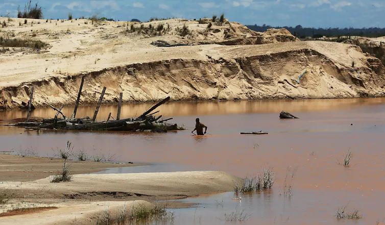
We have studied mercury pollution from artisanal gold mining for the past five years. The extraction methods that these operations use today are not drastically different from processes that miners employed in the California gold rush in the mid-1800s. Today we see history repeating itself in places like the Peruvian Amazon, where small-scale gold mining threatens to leave behind long-lasting social, economic and environmental consequences.
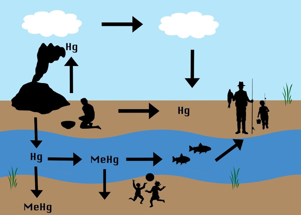
Mercury contamination from gold mining
Mercury has been used for centuries as an inexpensive and easy way to collect gold. The process begins when miners pump a mixture of water and sediment from a riverbed into a trough, where the sediment can be suspended into a slurry – a technique known as hydraulic mining.
Next they add mercury, which binds to the gold particles, forming an amalgam. Mercury is heavier than pure gold, so the balls of amalgam sink to the bottom of buckets or holding ponds where they can be collected. Finally, workers burn off the mercury – often with a hand torch or in a crude stove – leaving gold metal behind.
This process releases mercury to the environment in two forms. First, tailings, or waste material, can contaminate nearby land and aquatic ecosystems. Second, mercury vapor enters the atmosphere and can travel long distances before being deposited to land and water via rainfall or small dust particles.
In the environment, microbes can transform mercury into a more potent form known as methylmercury. Methylmercury can be taken up by bacteria, plankton and other microorganisms that are then consumed by fish and build up to dangerous concentrations in animals higher on the food chain.
When artisanal gold miners burn mercury, it is released into the atmosphere and can end up on land or in water. Mining tailings (solid waste) also deposit mercury onto land or into water. Microbes in the environment can convert mercury into methylmercury, which can be taken up by living organisms, including fish and people. Arianna Agostini, Rand Alotaibi, Arabella Chen, Annie Lee, Fernanda Machicao, Melissa Marchese, CC BY-ND
Methylmercury is a potent neurotoxin that is harmful to humans and wildlife, such as endangered giant otters that feed high on the food web within these contaminated environments. It can cause severe central nervous system damage that results in sensory and motor deficits, as well as behavioral impairments such as difficulty swimming in aquatic animals and flying in birds.
A lasting legacy in California
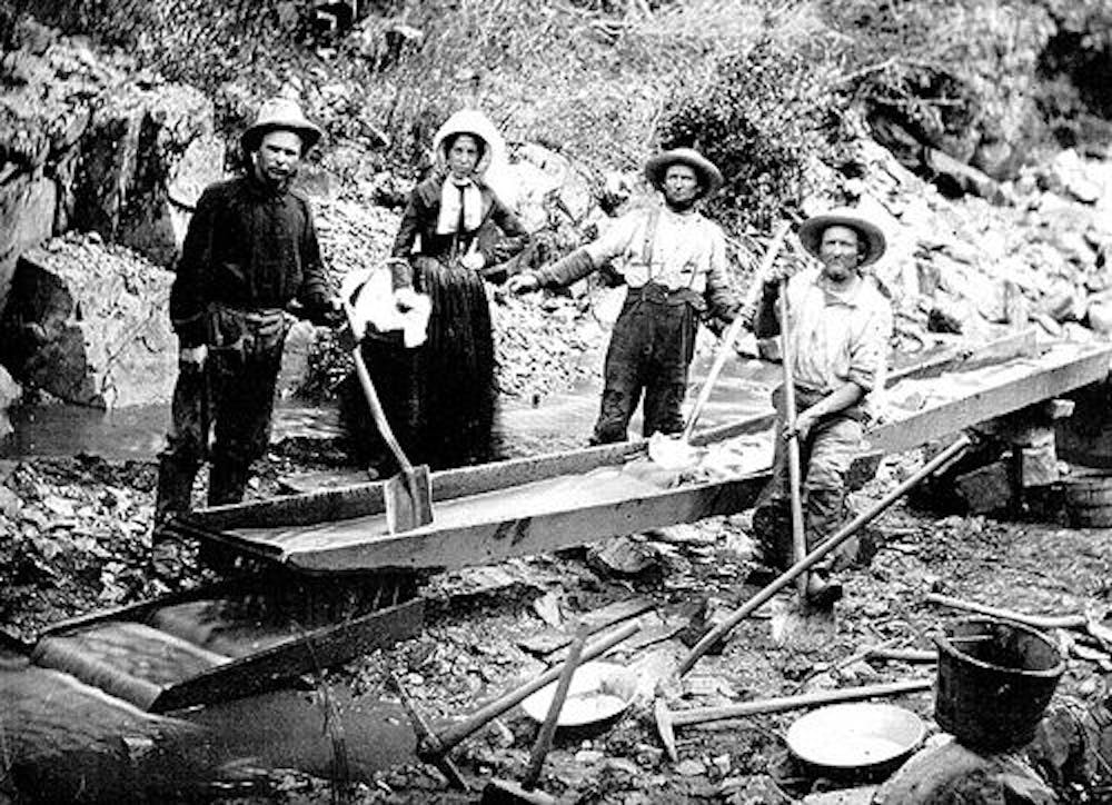
During the U.S. gold rush, hydraulic mining operations in California completely denuded forested landscapes, altered the course of rivers, increased sedimentation that clogged river beds and lakes and released enormous amounts of mercury onto the landscape. California wildcat miners used an estimated 10 million pounds of mercury from the 1860s through the early 1900s. Most of it was released to the environment as tailings and mercury vapor.
A century later, water, soil and sediments in the Sierra Nevada region still have high concentrations of mercury and methylmercury, often exceeding thresholds set by the U.S. Environmental Protection Agency. Studies show that fish, birds and other organisms living near historically mined sites in California have high mercury concentrations in their bodies compared to those inhabiting nearby unmined landscapes. Extreme erosion on mountain slopes can continuously mobilize mercury deposited decades ago.
History repeats itself
Like men who traveled to California in 1849 hoping to strike it rich, today’s artisanal miners around the world are mainly low-skilled workers hoping to support themselves and their families.
In Peru, where we have studied this process, artisanal miners produce an estimated 35,000 to 40,000 pounds of gold per year. The industry offers an opportunity for upward mobility for substantial numbers of Peruvians, who generally migrate to mining sites from coastal and mountain towns.
As a result, gold rush towns have boomed over the past 20 years. The Inter-Oceanic Highway, which was completed in 2012 and runs from Brazil’s Atlantic coast to Peru’s Pacific coast, has connected these towns to larger cities and increased access to the Peruvian Amazon.
Producing a pound of gold requires about 6 pounds of mercury. Given that at least 50% of the mercury used in these operations is lost to the environment, we estimate that artisanal gold mining in Peru alone releases nearly 50,000 pounds of mercury annually.
Mining in this region is producing impacts that are strikingly similar to the hallmarks of the California gold rush. For example, miners in the Peruvian Amazon have cleared more than 250,000 acres of forest since 1984.
The Madre de Dios River, which runs through a zone that has seen substantial mining, will likely continue to erode the landscape, carrying mercury-laden particles downstream. Long-lasting mercury contamination in this region threatens the highest biodiversity on the planet and many indigenous communities.
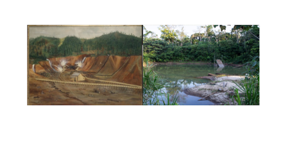
Comparison of landscape change from gold mining during the California gold rush (left) and modern artisanal mining in Peru (right). Bancroft Library, UC Berkeley (left); Arabella Chen (right)
Gold mining in 19th-century California sparked a wave of western migration and helped drive settlement of what we now refer to as the western United States at a time when mining and environmental pollution were unregulated. Today, use of mercury in artisanal gold mining is regulated by the 2013 Minamata Convention on Mercury, which has been signed by 128 countries – including Peru. Yet there is little on-the-ground regulation in most countries. Nor have governments addressed legacy pollution and deforestation from gold mining.
Illegal artisanal gold mining is a major source of income for local communities in places like the Madre de Dios region of Peru. As long as people all over the world continue to demand more gold, we believe that they are just as responsible as miners and local policymakers for the environmental degradation gold mining causes.
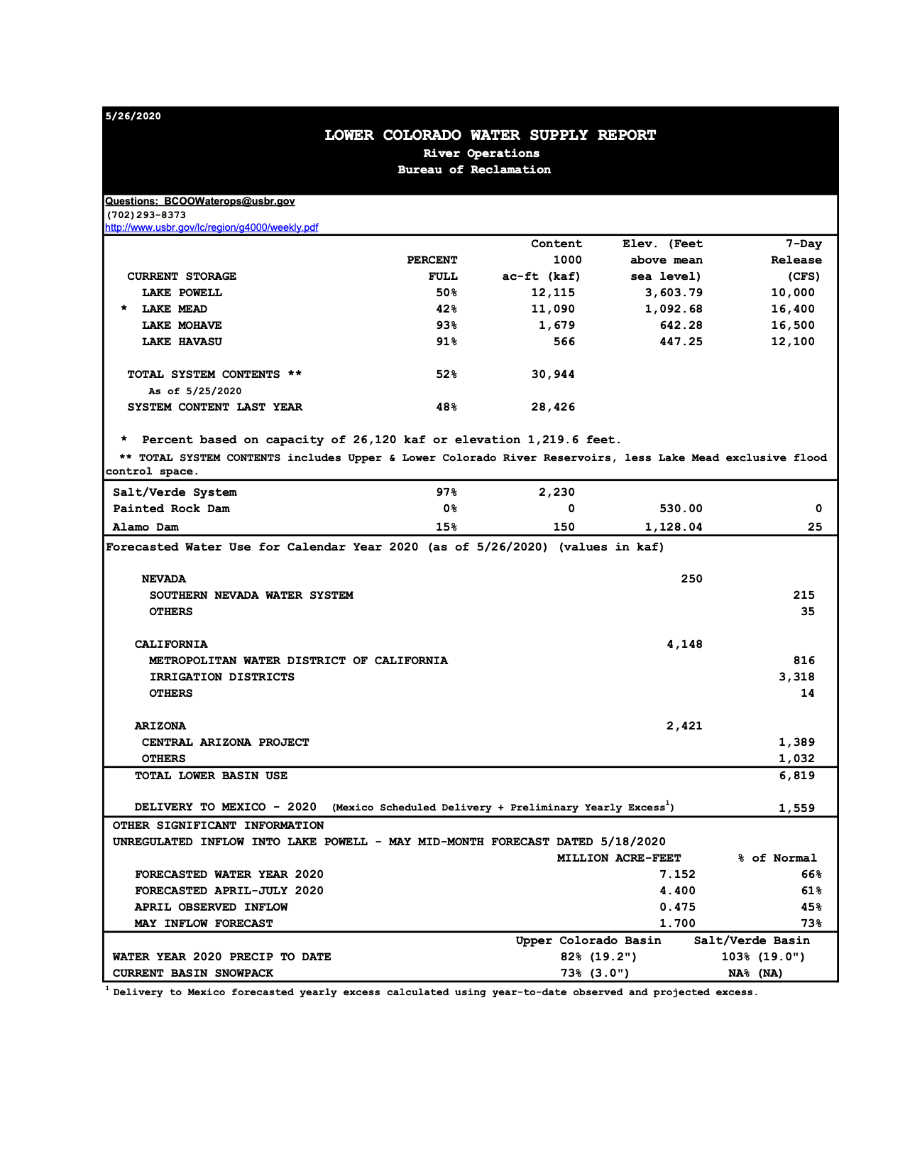
(May 17) projects April – July unregulated inflows into Lake Powell to be 61% of average, down from 74% of average forecast on April 17. Other spring reservoir inflow forecasts in the discussion include Fontenelle (88% average), Flaming Gorge (84% of average), Blue Mesa Reservoir (59% of average), McPhee Reservoir (35% of average), and Navajo Reservoir (50% of average). All forecasts are lower than last month, in some cases significantly lower.
(May 17) projects April – July unregulated inflows into Lake Powell to be 61% of average, down from 74% of average forecast on April 17. Other spring reservoir inflow forecasts in the discussion include Fontenelle (88% average), Flaming Gorge (84% of average), Blue Mesa Reservoir (59% of average), McPhee Reservoir (35% of average), and Navajo Reservoir (50% of average). All forecasts are lower than last month, in some cases significantly lower.
For information on what the forecast means for the water supply and reservoir operations in the Colorado and Gunnison basins in Colorado, you can review video and access presentation slides from the Mesa County State of the River webinar hosted by the Colorado River District and Hutchins Water Center, as well as the District’s other State of the River webinars.

