Denver Water expects its storage reservoirs to fill by early July. The post Mountain runoff picking up after snowpack hits 2020 peak appeared first on News on TAP.
Click here to read the report. Here’s the abstract:
Across the Upper Missouri River Basin, the recent drought of 2000 to 2010, known as the “turn-of-the-century drought,” was likely more severe than any in the instrumental record including the Dust Bowl drought. However, until now, adequate proxy records needed to better understand this event with regard to long-term variability have been lacking. Here we examine 1,200 y of streamflow from a network of 17 new tree-ring–based reconstructions for gages across the upper Missouri basin and an independent reconstruction of warm-season regional temperature in order to place the recent drought in a long-term climate context. We find that temperature has increasingly influenced the severity of drought events by decreasing runoff efficiency in the basin since the late 20th century (1980s) onward. The occurrence of extreme heat, higher evapotranspiration, and associated low-flow conditions across the basin has increased substantially over the 20th and 21st centuries, and recent warming aligns with increasing drought severities that rival or exceed any estimated over the last 12 centuries. Future warming is anticipated to cause increasingly severe droughts by enhancing water deficits that could prove challenging for water management.
In much of the western United States (hereafter “the West”), water demand (i.e., the combination of atmospheric demands, ecological requirements, and consumptive use) is approaching or has exceeded supply, making the threat of future drought an increasing concern for water managers. Prolonged drought can disrupt agricultural systems and economies, challenge river system control and navigation, and complicate management of sensitive ecological resources. Recently, ample evidence has emerged to suggest that the severity of several regional 21st-century droughts has exceeded the severity of historical drought events; these recent extreme droughts include the 2011 to 2016 California drought and the 2000 to 2015 drought in the Colorado River basin.
Conspicuously absent thus far from investigations of recent droughts has been the Missouri River, the longest river in North America draining the largest independent river basin in the United States. Similar to California and the Upper Colorado River Basin, parts of the early 21st century have been remarkably dry across the Upper Missouri River Basin (UMRB). In fact, our assessment of streamflow for the UMRB suggests that the widespread drought period of 2000 to 2010, termed the “turn-of-the-century drought” by Cook et al., was a period of observationally unprecedented and sustained hydrologic drought likely surpassing even the drought of the Dust Bowl period.
Northern Hemisphere summer temperatures are now likely higher than they have been in the last 1,200 y, and the unique combination of recent anomalously high temperatures and severe droughts across much of the West has led numerous researchers to revisit the role of temperature in changing the timing and efficiency of runoff in the new millennium. Evidence suggests that across much of the West atmospheric moisture demands due to warming are reducing the effectiveness of precipitation in generating streamflow and ultimately surface-water supplies.
The waters of the Upper Missouri River originate predominantly in the Rocky Mountains of Montana, Wyoming, and Colorado, where high-elevation catchments capture and store large volumes of water as winter snowpack that are later released as spring and early summer snowmelt. This mountain water is an important component of the total annual flow of the Missouri, accounting for roughly 30% of the annual discharge delivered to the Mississippi River on average, but ranging between 14% to more than 50% from year to year, most of which is delivered during the critical warm-season months (May through September). Across much of the UMRB, cool-season (October through May) precipitation stored as winter snowpack has historically been the primary driver of streamflow, with observed April 1 snow-water equivalent (SWE) usually accounting for at least half of the variability in observed streamflow from the primary headwaters regions. However, since the 1950s, warming spring temperatures have increasingly driven regional snowpack declines that have intensified since the 1980s. By 2006, these declines amounted to a low snowpack anomaly of unusual severity relative to the last 800 y and spanned the snow-dominated watersheds of the interior West. A recent reassessment of snowpack declines across the West by Mote et al. suggests continued temperature-driven snowpack declines through 2016 totaling a volumetric storage loss of between 25 and 50 km3, which is comparable to the storage capacity of Lake Mead, the United States’ largest reservoir.
Here we examine the extended record (ca. 800 to 2010 CE) of streamflow and the influence of temperature on drought through the Medieval Climate Anomaly, with a focus on the recent turn-of-the-century drought in the UMRB. The role of increasing temperature on streamflow and basin-wide drought is examined in the UMRB over the last 1,200 y by analyzing a basin-wide composite streamflow record developed from a network of 17 tree-ring–based reconstructions of streamflow for major gages in the UMRB (Fig. 1) and an independent runoff-season (March through August) regional temperature reconstruction. We also explore the hydrologic implications (e.g., drought severity and spatial extent) and climatic drivers (temperature and precipitation) of the observed changes in streamflow across the UMRB and characterize shifts in the likelihood of extreme flow levels and reductions in runoff efficiency across the basin.
The Missouri River Basin and its subregions. The location of the Missouri River Basin within the continental United States (gray watershed, upper right) and the location of the five hydrologically distinct subregions (colored watersheds) that define the UMRB. Reconstructed gages used to develop the estimate of basin-wide mean annual streamflow are shown as triangles. FromThe Washington Post (Darryl Fears):
For the first decade of the century, the Upper Missouri River Basin was the driest it’s been in 1,200 years, even more parched than during the disastrous Dust Bowl of the 1930s, a new study says.
The drop in water level at the mouth of the Missouri — the country’s longest river — was due to rising temperatures linked to climate change that reduced the amount of snowfall in the Rocky Mountains in Montana and North Dakota, scientists found.
The basin has continued to experience droughts this decade — in 2012, 2013 and 2017 — but their severity in comparison with historic drought is unknown. The “Turn-Of-The-Century Drought” study, published Monday in the Proceedings of the National Academy of Sciences, focused only on the 10 years after 2000.
“In terms of the most severe flow deficits, the driest years of the Turn-Of-The-Century-Drought in the [Upper Missouri River Basin] appear unmatched over the last 1,200 years,” the study said. “Only a single event in the late 13th century rivaled the greatest deficits of this most recent event.”
Researchers familiar with drought of this magnitude in the dry Southwest were surprised to find it in the Midwest…
“These findings show that the upper Missouri Basin is reflecting some of the same changes that we see elsewhere across North America, including the increased occurrence of hot drought” that’s more severe than usual, [Erika] Wise said.
The study is the latest to show how human-influenced climate change threatens to reshape the landscape by making naturally occurring drought far more severe.
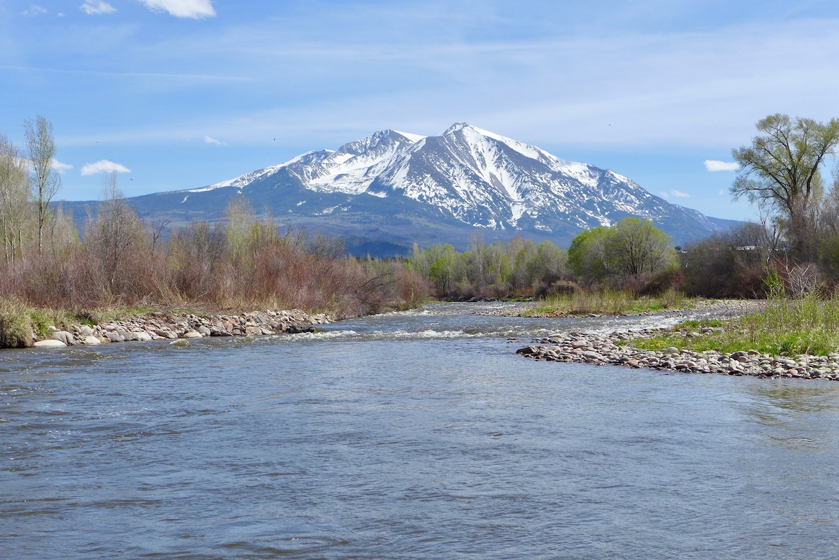
The lower Fryingpan River below Ruedi Reservoir. The Colorado River District owns water in Ruedi Reservoir and plays a role in the flows in the Fryingpan, which is heavily diverted to the eastern slope at its headwaters. Photo credit: Brent Gardner-Smith/Aspen Journalism
The results of a survey to gauge voters’ attitudes about the Colorado River Water Conservation District and Western Slope water returned some good news for the district. But due to concerns about the economic crisis caused by the COVID-19 pandemic, River District officials are still mulling whether to push ahead with a plan to ask voters to restore part of its original mill levy.
River District general manager Andy Mueller said the overall results of the survey, which found that 65% of respondents would support a mill levy increase, were a ray of good news in an otherwise dark time. But at the board’s April quarterly meeting, Mueller recommended that it postpone making a decision about whether to move forward on a ballot initiative until at least its July meeting.
“Given the economic devastation that is occurring throughout the district, the question we have to ask ourselves in July is: Is it appropriate to go to the voters to ask for additional funding at this time when they are suffering such great economic hardship?” Mueller said. “I don’t know the answer to that.”
The River District board is considering whether to ask voters to raise its property tax rate from a quarter-mill to a half-mill, taking its budget from about $4 million to $8 million. That works out to 50 cents for every $1,000 of assessed property value. One mill is the equivalent of $1 per $1,000 of assessed value.
According to numbers provided by the River District, for the median home value in Pitkin County — the highest in the district at $1.13 million — the mill levy would increase from $18.93 to $40.28 per year.
For several days in mid-March, River District consultant Arvada-based New Bridge Strategy surveyed about 600 residents and voters via email and phone to assess the feasibility of a ballot question. The survey results found that residents trust that the River District manages taxpayer funds wisely, and three out of five people said they would support a tax increase if it were on the ballot measure in November.
“I think, overall, this is positive,” said Lori Weigel, principal of New Bridge Strategy. “It’s pretty rare to see something testing at 60 percent or higher in Colorado these days. It speaks to the primacy of water and people’s concern about water in this part of the state.”
Survey-takers said protecting western Colorado water for agriculture and preserving clean drinking water were the most compelling reasons to vote yes on a tax increase. Eighty-eight percent found these reasons convincing. The River District is not a direct provider of drinking water, but part of the organization’s mission is to keep water on the Western slope.
Women older than 55 years old made up the backbone of support for a tax measure — 73% said they would back it. Residents across the political spectrum supported a tax increase, but it found the most support from Democrats, with 75% saying they would vote “yes.” Fifty-six percent of Republicans were supportive.
The Roaring Fork River just above Carbondale, and Mt. Sopris, on May 3, 2020. The Colorado River District works to keep water on the Western Slope, including in the Roaring Fork. Photo credit: Brent Gardner-Smith/Aspen Journalism
Mesa County
The Glenwood Springs-based River District, created in 1937 to protect and develop water supplies in western Colorado, spans 15 counties: Grand, Summit, Eagle, Pitkin, Rio Blanco, Routt, Moffat, Garfield, Mesa, Delta, Montrose, Ouray, Gunnison, Hinsdale and Saguache. The survey found broad geographic support overall, but the numbers were lowest in one key, populous county: Mesa. Only 59% of survey respondents there said they would support a tax increase.
“What it means to me is that we need to do better and make sure that if there are places that others perceive we are not speaking and advocating well for agriculture, then we need to do it more uniformly,” Mueller said.
Steve Acquafresca, who represents Mesa County on the River District board, said probably only a small percentage of voters know what the River District does, and although the River District has ramped up its outreach to Western Slope communities this year, more is needed. Those efforts, however, have been sidelined by the pandemic. The River District had scheduled a series of State of the River meetings this spring, which were canceled.
“It’s a huge challenge,” Acquafresca said. “That’s a huge disadvantage of going forward with a question in 2020 if we can’t get out and do the campaigning.”
He also pointed out that the results of the survey may no longer be valid because of its timing.
“Although some of the results look pretty good, all of that was done before the pandemic really impacted our Western Slope communities,” Acquafresca said. “Nobody had any concept of the economic consequences of this pandemic on big cities and small towns alike.”
For the median home value in Mesa County, at $218,601, the mill levy would increase from $3.67 to $7.81 per year.
A view of the White River between Meeker and Rangely. The Colorado River Water Conservation District includes the White River basin, and the district is supporting an investigation into a new storage project on the White. Photo credit: Brent Garndner-Smith/Aspen Journalism
Projects plan
River District staffers also have unveiled a fiscal implementation plan for how that additional funding could be spent should voters pass a ballot measure. Of the projected $4.9 million in additional revenue, $4.2 million of that would be spent on projects identified as priorities by local communities and basin roundtables in five categories: productive agriculture, infrastructure, healthy rivers, watershed health and water quality.
Some representative projects that River District revenue could help fund are the White River Storage Project, maintaining flows secured by the Shoshone call and the Windy Gap Reservoir connectivity channel.
The state engineer is opposing the water rights tied to the White River Storage Project in water court over concerns that the project is speculative and that the applicant, the Rio Blanco Water Conservancy District, has not proven there is a need for the water. The project would include a 90,000-acre-foot conditional storage right, and a dam and reservoir on the White River between Rangely and Meeker. But Mueller said it’s too early to know what specific projects the River District’s tax money might fund.
“We can’t say we would fund any one of those in particular; those are examples,” Mueller said. “We are not making a commitment to funding any of those that are listed.”
Aspen Journalism is a 501(c)(3) nonprofit organization, supported by its donors and funders, that covers water and rivers in collaboration with The Aspen Times and other Swift Communications newspapers. This story ran in the May 8 edition of The Aspen Times and the May 12 edition of the Vail Daily.
The Colorado River Water Conservation District spans 15 Western Slope counties. River District directors are considering asking voters this fall to raise the mill levy.
Snowpack levels in the San Juan Mountains of southwestern Colorado typically peak in April or early May, before starting a rapid downward slide as temperatures rise and spring runoff gets underway. This water year — which so far has tracked just below average in terms of snowpack — appears to be following the “normal” pattern. Yet it also continues a trend of earlier, and diminishing, snowpack-peaks.
This slideshow requires JavaScript.
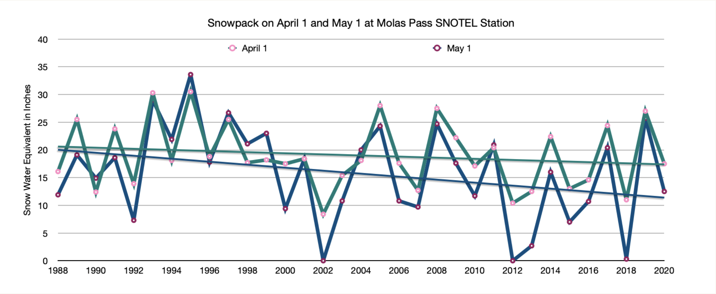
For the last few years I’ve been following, graphing, and posting snow water equivalent levels at three high-altitude SNOTEL stations: Columbus Basin, located in the La Plata Mountains west of Durango; Red Mountain Pass; and Molas Lake (near Molas Pass). Looking back at the graphs one thing that immediately stands out is that there is no “normal.” Terrifyingly dry years (2018) are often followed by wickedly wet ones (2019).
However trends do appear. Notice in the graphs below that although the snowpack level for the first of April and May fluctuate wildly from year-to-year, the overall trend line is on a downward slope. Also note that in the ’80s and ’90s the levels on May 1 were as likely to be higher than on April 1, but as time goes on, the peak tends to be earlier. This would appear to be a sign of a warming, drying climate (at least for this admittedly small sample size and short period of record).
This slideshow requires JavaScript.
Something not seen in these graphs: A hot early May has melted a lot of snow. If the current melting rate continues, there won’t be any snow left by June. And that could mean that the Animas River already hit its peak, topping out at about 2,200 cfs on May 5. That would be a pretty disappointing spring runoff. The warm temperatures have also put most of the region into some level of drought conditions, despite the near-average-snowfall this winter.
Of course, you never know what might happen this time of year in the San Juans. Temperatures could fall, and big storms might still hit. But don’t count on it.