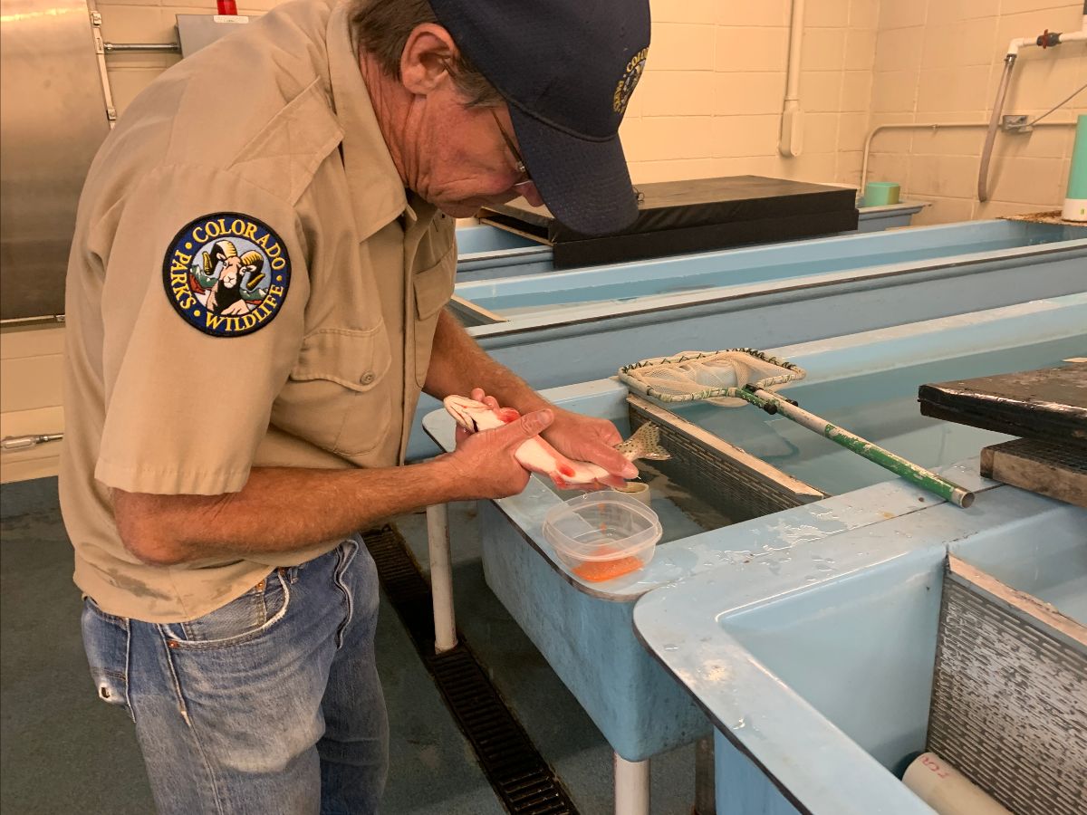
Toby Mourning, manager of the Durango fish hatchery for Colorado Parks and Wildlife, takes eggs from a rare San Juan cutthroat trout. Photo credit: Colorado Parks and Wildlife
Here’s the release from Colorado Parks and Wildlife (Joe Lewandowski):
After nearly a two-year wait, Colorado Parks and Wildlife hatchery staff and biologists in Durango have spawned a new lineage of Colorado River cutthroat trout that were rescued from a remote stream during the 416 Fire in 2018.
This marks a major milestone for CPW’s on-going species conservation work in Colorado, and the result of decades of work by dedicated biologists, researchers and field staff.
Fertilized eggs of the San Juan cutthroats will hatch by mid-summer; some of the fingerlings will be placed in back-country streams in the southwest area of the state and others will be held at the Durango hatchery to start a sustainable brood stock. Now, the hatchery staff and biologists will continue the long-term effort to restore these native trout to their home waters.
“I’m thrilled that we’ve gotten a spawn from these fish, it’s been a long process and we’ve got a lot more work to do,” said Jim White, aquatic biologist for CPW in Durango.
The story of these fish that hold a unique genetic marker goes back nearly 150 years and includes some serious biological detective work. Since the 1970s, CPW aquatic biologists have searched back-country streams looking for isolated populations of cutthroats — Colorado’s native trout. In southwest Colorado in the 1980s and 1990s, biologists found cutthroat trout that were suspected to have unique characteristics in eight small streams. Back then, however, technology to analyze genetics fully was still being developed. The biologists kept their eyes on the fish and made sure non-native trout were not stocked nearby.
In 2012, researchers from the University of Colorado went to the Smithsonian National Museum of Natural History looking for preserved specimens of cutthroat trout that had been collected in Colorado. Two of the specimens they found were taken from the San Juan River near Pagosa Springs in 1874.
An analysis showed that the fish had genetic “fingerprints” specific to the San Juan River Basin. CPW researchers then began a similar analysis of the cutthroats they’d found in southwest Colorado. By this time, genetic-analysis technology had advanced and in early 2018 scientists confirmed that the marker in the museum specimens matched the cutthroat trout recently found in the wild.
Biologists and hatchery staff then made a plan to start propagating the fish. The 416 Fire helped push the project along.
The 416 Fire near Durango, Colorado, ignited on June 1, 2018. By June 21, the wildfire covered more than 34,000 acres and was 37 percent contained. Photo credit USFS via The High Country News
When the fire started north of Durango, biologists worried that ash and sediment run-off could kill the cutthroats in the remote streams. So CPW worked with the San Juan National Forest to go into the area to capture the wild trout and bring them to a special isolation hatchery in Durango. Only 54 cutthroat were recovered from the fire area.
White and Durango Hatchery Manager Toby Mourning have been concerned because the fish did not produce any spawn last year and some of the fish died. But the turnaround this year is a major milestone for the restoration effort.
“We’re not getting a lot of eggs, but enough to provide some for a limited amount of stocking and some to start a captive population that will be sustainable,” Mourning said.
In order to protect the fish, CPW is not providing details on stream locations. Biologists hope, however, that in a few years anglers will be able to find this unique cutthroat trout in the wild.
White explained that the work on this native is a significant conservation effort. In 2018, after the genetics of the fish were confirmed, he said: “We always ask ourselves, ‘What if we could go back to the days before mining, pioneer settlement and wide-spread non-native fish stocking to see what we had here? Careful work over the years by biologists, finding those old specimens in the museum and the genetic testing gave us the chance, essentially, to go back in time. Now we have the opportunity to bring this native trout back to southwest Colorado.”
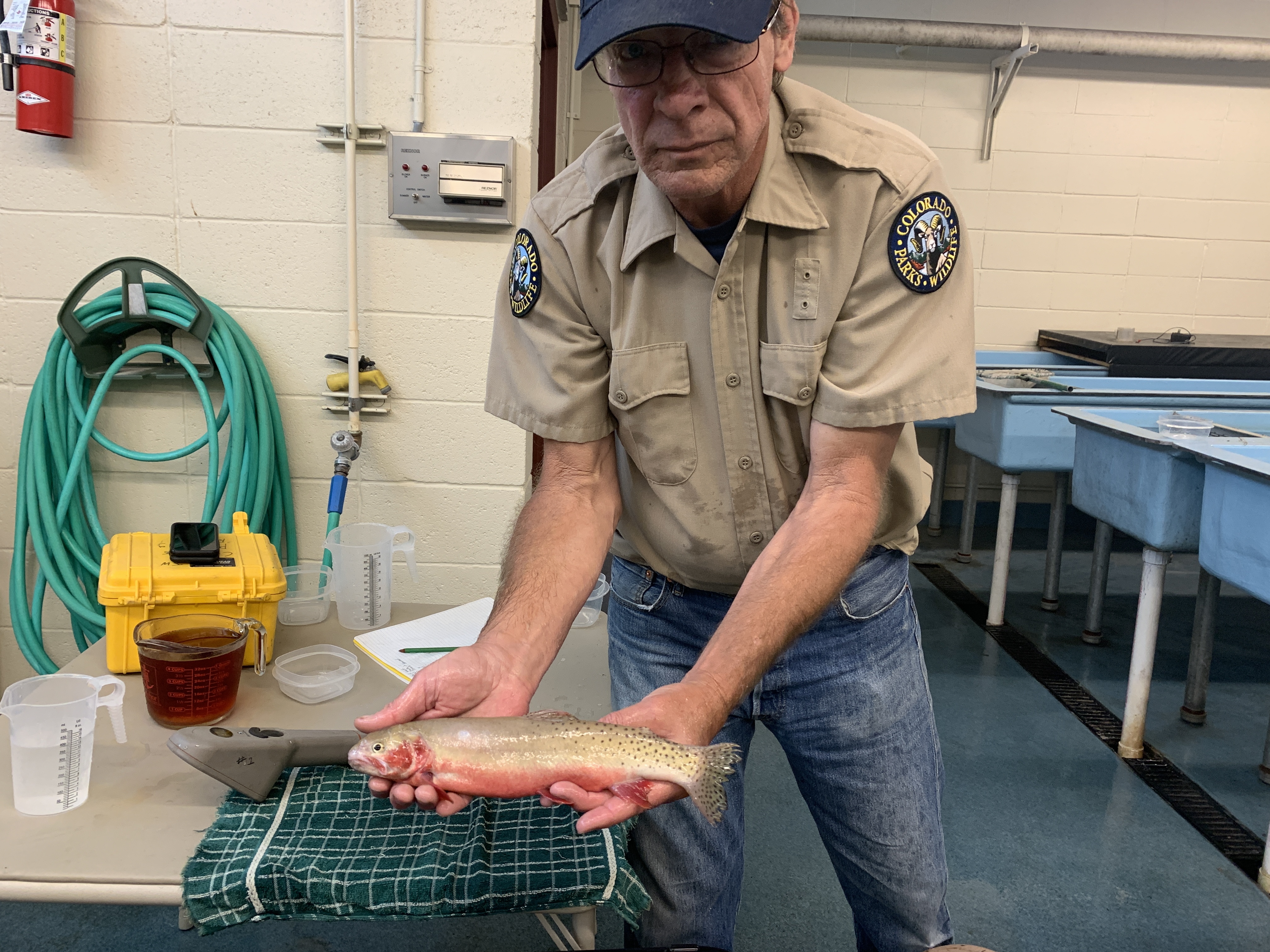
Beautiful San Juan “Cut” May, 2020. Photo credit: Colorado Parks and Wildlife
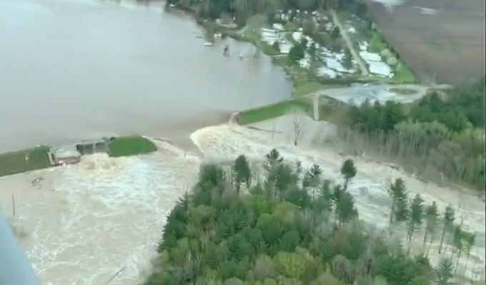
Here’s the release from the USGS. Click through for all the links and a great animation of one reach of the stream below the dam failures:
U.S. Geological Survey field crews are measuring record flooding on the Tittabawassee River in Midland, Michigan, following a heavy rainfall event.
The USGS Tittabawassee River in Midland streamgage measured record water levels, called river stage, at about 35 feet on Wednesday. This level is the highest ever recorded during the streamgage’s 84 years of record, and exceeds the previous highest stage by about two feet. Water levels are beginning to recede as of this morning, and two two-person USGS crews are measuring streamflow in Grayling and Lansing. They also installed a rapid-deployment gage to provide backup to the permanent streamgage at the Midland site.
Strong storms passed through parts of the Midwest starting last Thursday, causing minor-to-major flooding in some lower Michigan locations. On Tuesday, May 19, two large dams on the Tittabawssee River failed in succession, causing two lakes upstream of Midland to drain. The USGS crews will continue to monitor water levels and streamflow as flooding continues.
Elsewhere in Michigan, the USGS Rifle River streamgage near Sterling crested on Tuesday with a record streamflow of 7,460 cubic feet per second. There are currently four additional single-person crews measuring streams throughout lower Michigan, and they will continue to monitor flooding for at least another day.
Information collected by the USGS during flooding is critical for resource managers and emergency responders to help protect life and property. The USGS coordinates efforts with the National Weather Service, US Army Corps of Engineers, Bureau of Reclamation and many local and state partners.
There are about 200 streamgages in Michigan that measure water levels, streamflow and rainfall. When flooding occurs, USGS crews make numerous streamflow measurements to verify the data USGS provides to federal, tribal, state and local agencies, as well as to the public.
For more than 125 years, the USGS has monitored flow in selected streams and rivers across the U.S. The information is routinely used for water supply and management, monitoring floods and droughts, bridge and road design, determination of flood risk and for many recreational activities.
Access current flood and high flow conditions across the country by visiting the USGS WaterWatch website. Receive instant, customized updates about water conditions in your area via text message or email by signing up for USGS WaterAlert. See where floodwaters go by following a stream trace at Streamer. View water data on your mobile device. Learn how a USGS streamgage works.
Edenville Dam failure May 2020. Photo credit: American Rivers
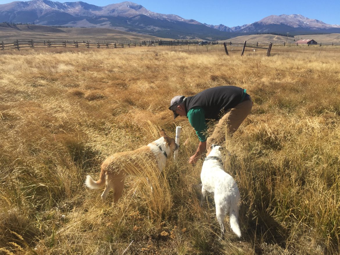
Brad Johnson, a wetland ecologist for the Rocky Mountain Fen Research Project, takes groundwater measurements at the research site near Leadville, while his dogs, Katie and Hayden watch. The cities of Aurora and Colorado Springs are looking to develop additional water in Eagle County and divert it to the Front Range. Photo credit: Sarah Tory/Aspen Journalism
On behalf of the State of Colorado, Attorney General Phil Weiser today filed a lawsuit in federal district court in Denver to protect Colorado’s streams and wetlands from a dangerous federal rule that would leave them vulnerable to pollution under the Clean Water Act.
By radically changing how the U.S. Environmental Protection Agency and the U.S. Army Corps of Engineers define “waters of the United States” that are protected under the Clean Water Act, the new 2020 rule will leave a substantial portion of Colorado’s streams and wetlands without federal protection and jeopardize the integrity and quality of Colorado’s waters.
“The federal government’s new definition of ‘waters of the United States’ violates the Clean Water Act, contravenes controlling U.S. Supreme Court precedent, and ignores sound science,” Weiser said. “This illegal action shirks the federal government’s responsibility to implement this law and thrusts on Colorado the responsibility of protecting water quality with limited warning and with no support to do so. We are bringing this lawsuit to stop this new rule and reckless action from taking effect.”
The Clean Water Act protects U.S. streams, wetlands, and rivers from pollution. Previously, under Supreme Court precedent, the rule included ephemeral streams—streams that run because of melting snow or precipitation—and wetlands that aren’t connected on the surface to larger bodies of water.
“We need to challenge this action to avoid a bigger problem for our economy at a time when our state is already hurting from COVID-19. Some flood control, stormwater erosion, transportation, and other important projects may not be able to move forward because the new rule takes away the permitting path needed to ensure environmental protection and project development. That’s a problem that we need to fix,” said John Putnam, Environmental Programs Director, Colorado Department of Public Health and Environment.
The new 2020 rule does not include many ephemeral streams or wetlands without a surface connection. The lawsuit states that the new, narrower definition of the types of water protected under the Clean Water Act eliminates federal jurisdiction over a significant number of Colorado’s tributaries, adjacent waters, and wetlands that affect downstream waters, without providing any rational basis for the rule. This leaves Colorado’s snowmelt streams and wetlands vulnerable to pollution, which would negatively impact our state’s agriculture and outdoor recreation economy.
Through the lawsuit, Colorado is asking the court to maintain the definition in place since the 1980s and to stop the new, unlawful rule from going into effect. In so doing, Colorado is following up on its comment to the agencies, which praised earlier 2008 guidance as legally sound and grounded in science. Maintaining the status quo will also protect important agriculture exemptions, respect state authority to administer water rights, and provide the appropriate level of federal partnership.
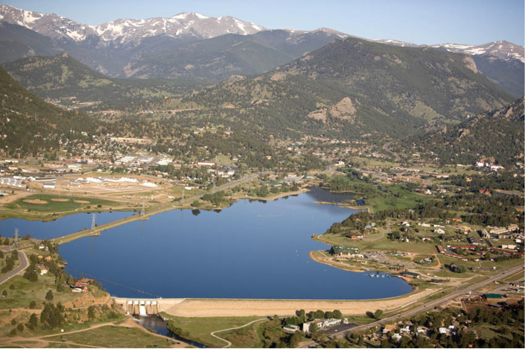
The Bureau of Reclamation will increase diversion of Colorado River water to Horsetooth Reservoir at midnight tonight. The change will require a decrease in the Big Thompson River diverted for power generation at Olympus Dam.
Reclamation is currently releasing 125 cfs to the Big Thompson River from Olympus Dam. The flow will increase to 265 cfs beginning tonight. Our current forecast indicates that runoff into Lake Estes will substantially increase over the next week. It is possible the Olympus Dam required release to the Big Thompson River will exceed 600 cfs.
Aerial view of Lake Estes and Olympus Dam looking west. Photo credit Northern Water.
A Saturday morning stroll through your local farmers market, is there anything like it? It’s a popular way that many Front Range people decide to spend their weekends, where you get to peruse the abundance and score some of the best food you can buy.
They fill their baskets with organically grown produce, chat with a farmer, walk over to a food truck for a coffee and a pastry and head home with their bounty. These brief interactions allow people to connect with where their food is grown, and put a face to the people who run these farms. But those interactions are threatened, and no, not because of COVID-19.
I am the Board President of the Valley Organic Growers Association (VOGA), representing over 125 farmers, ranchers, vineyard owners and related business operators in the North Fork Valley of western Colorado, many of whom travel to the Front Range to provide food to residents, restaurants, and breweries.
We take pride in being able to grow high-quality food, carefully tended and responsibly grown without additives or chemicals.
We also take pride in providing that food to Coloradans throughout the state. For many of us farmers, the food we grow is an extension of our personalities and represents us and our businesses.
VOGA’s vision is to create a vibrant community of prosperous, local farms that sustain the land and provide healthy agricultural products. To achieve this vision, we are dependent on our public lands.
Earlier this month, the Trump Administration approved a plan that puts the farms in our watershed at serious risk. The Bureau of Land Management’s final plan for the North Fork Valley opens our public lands to oil and gas drilling while removing protections for everything else that matters to us in the North Fork Valley.
For the past 10 years, the Bureau of Land Management has been rewriting a plan to manage the public land in the North Fork Valley. Our area is approximately 40% public land, which includes the headwaters of streams, rivers and ditches that supply irrigation water to our local farms.
VOGA has been participating and commenting on the BLM’s plan every step of the way. We even helped write our own proposal, called the North Fork Alternative, for how public land should be managed in our watershed.
The North Fork Alternative represents a locally grown vision for the North Fork Valley that would keep energy development away from sensitive areas and fosters a diverse, resilient economy. We were glad to see that the BLM included the North Fork Alternative in the planning process in 2016.
In the name of energy dominance, however, the Trump Administration completely dismissed our proposal last week and opened the entirety of our watershed to oil and gas development, without proper restrictions to protect our farms, our food or our livelihoods.
If resource extraction takes off in our watershed, our waterways may become polluted, ruining our region’s model for farm-to-table community agriculture.
Earlier this year, VOGA received a grant to conduct a study on our member’s economic impact within Delta County. For the 167 members of our association, we found the estimated total market value of our farms to be $50-60 million, with estimated annual gross sales to be $4.1 million.
If we want to maintain these numbers and build upon them to support a sustainable, resilient local economy, we need strong protections for our lands, air and water. And that begins with stipulations set forth in the BLM’s plan.
Luckily, Sen. Michael Bennet is on our side. Time and again, his commitment to working with local farmers, ranchers, business owners and conservationists has shined through in the face of this terrible plan.
And now it is no different. Sen. Bennet, thank you for your commitment to protecting the North Fork Valley, and we hope to work with you on a path forward, as farmers and as the local community.
Join us for a two-part miniseries of our podcast series We Are Rivers. We’ll learn more about Stream Management Plans, an innovative planning tool prioritized in Colorado’s Water Plan, from people working with stakeholder groups and communities across Colorado to put them in place.
Orr Manufacturing Vertical Impact Sprinkler circa 1928 via the Irrigation Museum
Water has always been the architect of life in Colorado. Communities have worked within the availability, demands, and constraints of water to engineer lives and livelihoods. Water designs our lives as much by its availability as it does by scarcity—perhaps even more. In 2013, the State of Colorado recognized the impending impacts of rising populations, increasing demand across the state and the West, and a changing climate, then-Governor John Hickenlooper called for a plan to address these issues. He directed the Colorado Water Conservation Board—the government entity tasked with conserving, developing, protecting and managing the state’s water—to work with diverse stakeholders and develop Colorado’s first water plan. You can learn more about the Plan from Episode 6 in our podcast series.
Seven-point draft conceptual agreement framework for negotiations on a future transmountain diversion screen shot December 18, 2014 via Aspen Journalism
In some ways, Colorado’s Water Plan articulated and formalized ways to meet the needs of agriculture, land use, and storage that were already in place. But it also did something else: for the first time, the Colorado Water Plan called for the consideration and integration of environmental and recreational flow needs. This decision came from growing recognition of the critical role rivers play in local economies, and the immense ecosystem services that healthy, functioning rivers and streams provide for all values—human and environmental. With this in mind, the Water Plan outlined a goal of inspiring community-driven development of Stream Management Plans for 80 percent of locally prioritized rivers and streams.
In the first episode of this miniseries, we hear from Nicole Seltzer, Science and Policy Manager of River Network, who talks us through the fundamentals of the stream management planning process. Holly Loff, Executive Director of Eagle River Watershed Council, shares on-the-ground experiences of a community planning effort along the Eagle River, and Chelsea Congdon-Brundige, a watershed consultant in the Roaring Fork Valley, shares her highlights from a similar but unique effort for the Crystal River.
As you’ll hear in the podcast, a critical component of Stream Management Planning is the diversity of stakeholders and interests at the table; the important and foundational role of science; and the way each Plan is unique to the community that builds it. SMP’s (as they’re often referred to) are really more about process than a final product, and the greatest win is the long-lasting trust inspired through tough but important conversations across values. SMPs aren’t designed to prioritize any one interest, but instead to bring agriculture, the environment, municipal needs, and recreation alongside one another for the best possible solutions for all.
Screen shot from the Vimeo film, “Rio Grande Headwaters Restoration Project: Five Ditches,” https://vimeo.com/364411112
If you’re inspired by this first Episode, and we suspect you will be, make sure to tune in for part 2 (coming 6/1/20) . We’ll hear from some of the same voices and from new ones from the Rio Grande Basin – including Heather Dutton with the San Luis Valley Water Conservancy District and Emma Reesor with Rio Grande Headwaters Restoration Project – about the groundbreaking and inspiring ways communities are working together to plan for the future of the rivers and streams that bind them, and all of us, together. Join us – and listen in today!