FromThe Grand Junction Daily Sentinel (Dennis Webb):
The toothy, predacious fish hasn’t broken any laws on its own, but someone is thought to have done so by introducing the nonnative species into Kenney Reservoir on the White River.
It’s a fish that’s fun to catch and great to eat, said Colorado Parks and Wildlife spokesman Randy Hampton. But it also wreaks havoc on populations of rainbow trout and other species that make up the fishery at Kenney. Worse yet, northern pike pose a threat to endangered fish that are part of an intensive recovery program in the Upper Colorado River and its tributaries in Colorado, Utah and Wyoming.
That’s the back story behind why CPW and the Rio Blanco Water Conservancy District are working with partners to offer anglers a $20 reward through Nov. 30 for every northern pike caught and removed from Kenney Reservoir, the White River and other waters from approximately Stedman Mesa to the Utah border…
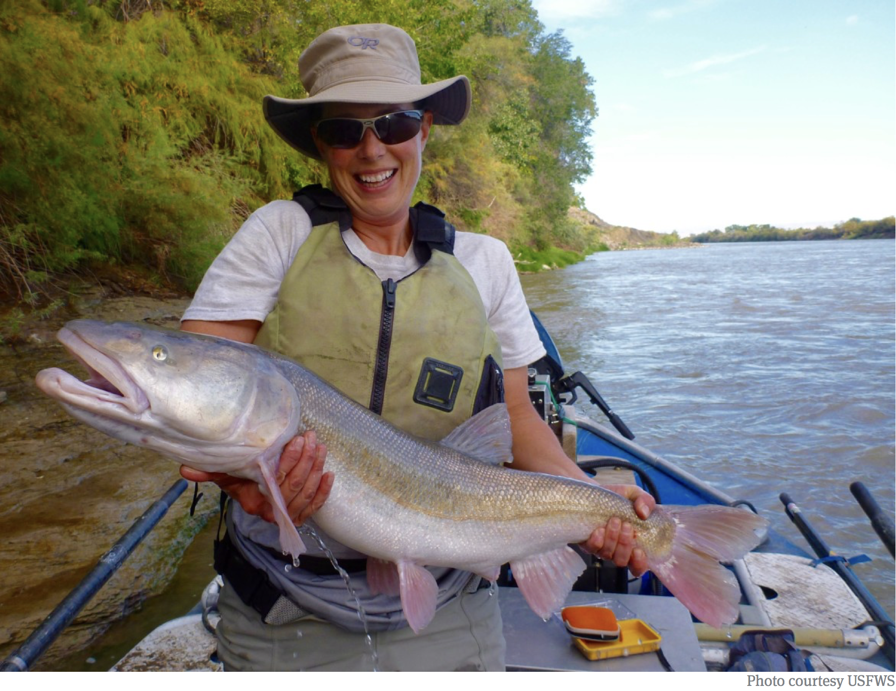
A Colorado pikeminnow taken from the Colorado River near Grand Junction, and in the arms of Danielle Tremblay, a Colorado Parks and Wildlife employee. Pikeminnows have been tracked swimming upstream for great distances to spawn in the 15-mile stretch of river between Palisade and Grand Junction. An apex predator in the Colorado, pikeminnows used to be found up to six feet long and weighing 100 pounds. Photo credit: Brent Gardner-Smity/Aspen Journalism
Another concern is the threat pike pose to Colorado pikeminnow, one of four endangered fish that are the focus of the Upper Colorado River Endangered Fish Recovery Program. The largest adult population of the Colorado pikeminnow is on the lower White River, which is designated critical habitat for the fish upstream and downstream of Kenney Reservoir. The lower 18 miles of the White River in Utah is designated critical habitat for the endangered razorback sucker.
The reward for northern pike was first offered last year, and just 19 fish were turned in. Hampton said northern pike can be harder to catch, favoring deep, cool waters farther from shore. Organizers hope for more participation this year, to get anglers more involved in the efforts to eradicate the northern pike around Rangely.
Participants should bring their freshly caught northern pike to CPW’s office in Rangely from 7 a.m. to 4 p.m. on Mondays through Thursdays and 7 a.m. to 3 p.m. on Fridays. CPW staff will dispense reward money that comes from the Colorado Water Conservation Board, and is sourced from the state Species Conservation Trust Fund generated by severance tax dollars.
Partners in the effort also are planning a weekend fishing derby and expo June 5-7. It includes a $250 prize for whoever brings in the most smallmouth bass, another nonnative predator. With COVID-19 social-distancing measures being heeded, there will be interactive learning opportunities, a display of an electrofishing boat and an aquarium display including endangered fish.
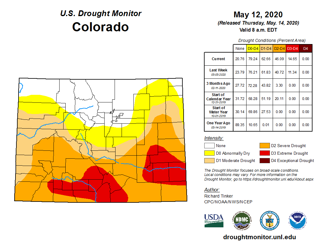
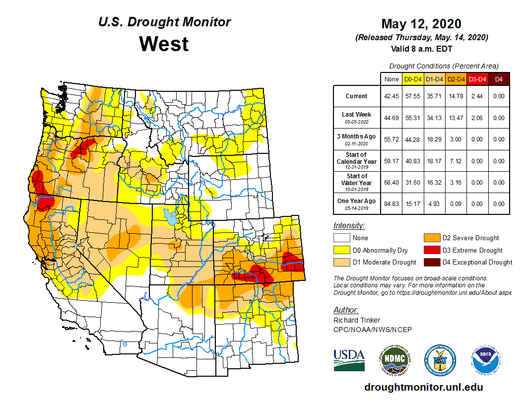
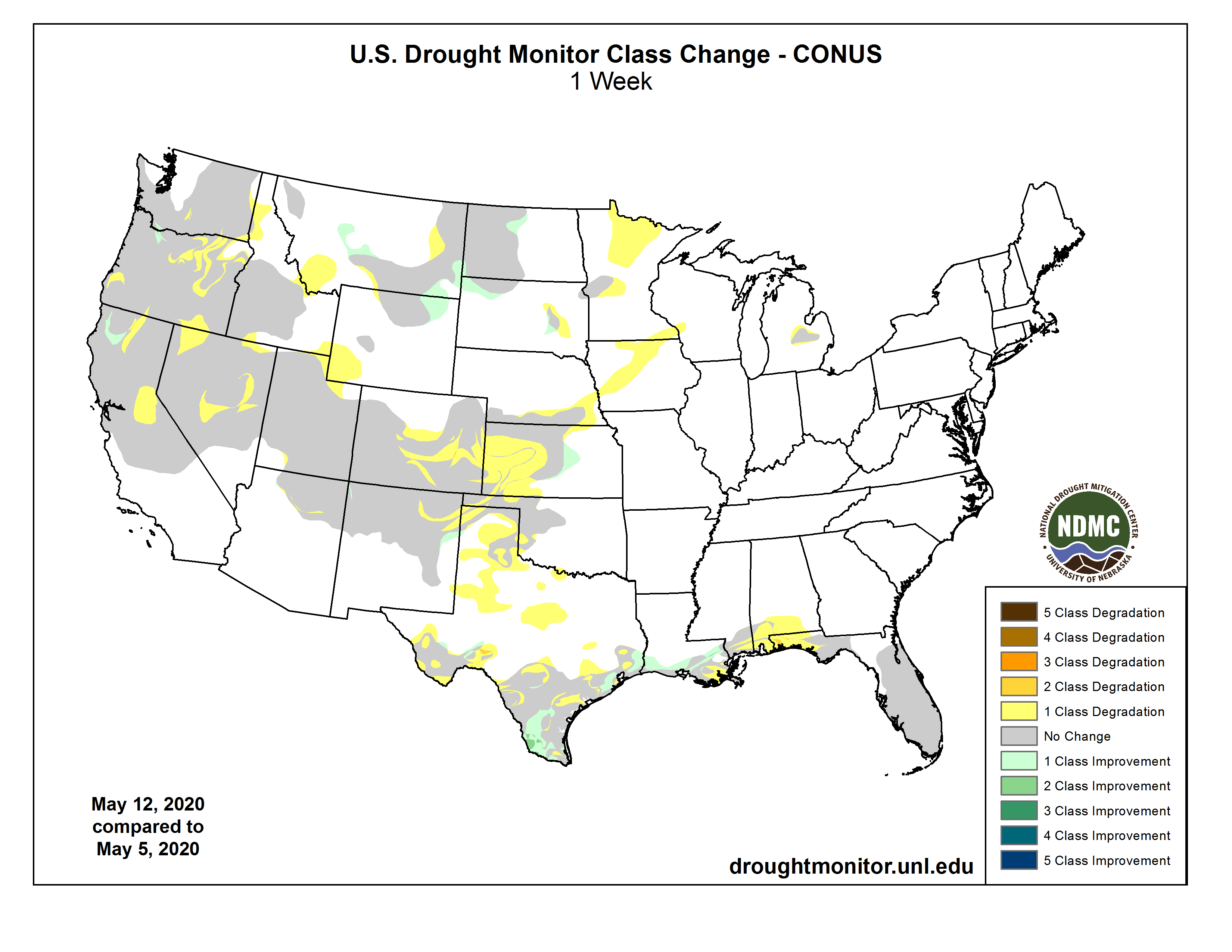
Click on a thumbnail graphic to view a gallery of drought data from the US Drought Monitor.
US Drought Monitor May 19, 2020.
West Drought Monitor May 19, 2020.
Colorado Drought Monitor May 19, 2020.
Click here to go to the US Drought Monitor website. Here’s an excerpt:
This Week’s Drought Summary
The southern Plains, Mississippi Valley, Pacific coast and south Florida were the recipients of the greatest rains this week, with some areas of Louisiana and south Florida recording 5+ inches of rain for the week. Dryness over the East and West was also coupled with warmer than normal temperatures over the West. Temperatures were 3-6 degrees above normal over the Nevada, Utah, Colorado and New Mexico regions while the northern Plains was 6-9 degrees below normal. Many dry areas of the Plains and Midwest have not had drought development due to the unseasonably cool temperatures in May…
Temperatures over the region were generally 6-8 degrees below normal, with portions of Colorado and Wyoming the outliers with temperatures 2-4 degrees above normal. Most of the region was fairly dry for the week with many areas below normal for precipitation during one of the wettest months of the year. Portions of western South Dakota, western Nebraska, northeast Colorado, and southeast Kansas did record precipitation that was well above normal with 150-400 percent of normal for the week. With the dryness throughout much of the area, abnormally dry conditions were expanded and moderate drought was introduced to portions of western North Dakota and into South Dakota. Abnormally dry conditions were expanded through central and southeast Nebraska and portions of northeast Kansas. These areas will be ripe for drought development without rain, especially if temperatures become more seasonable. Northeast Colorado did see some improvement due to recent heavy rains as the severe and moderate drought as well as the abnormally dry conditions shifted south slightly. The abnormally dry pocket in southeast South Dakota was also removed this week after some locally heavy rain…
Most of the region was dry for the week with the exception of the Pacific Northwest and northern California, where 150-200 percent of normal precipitation was recorded. Temperatures for the region were 3-6 degrees above normal over central Nevada, Utah, Colorado, and eastern New Mexico, with most of the rest of the region near normal to 3 degrees below normal for the week. In the Pacific Northwest, the recent rains helped to slow down further degradation in Oregon and Washington, with portions of the abnormally dry areas of western Washington improved this week. Oregon has some improvement to the severe and extreme drought over the southwest portions of the state but did see moderate drought expand slightly over portions of the western areas of the state. Conditions in Nevada and Utah continue to decline with an intensification of moderate and severe drought over northern portions of both states as the short-term dryness is starting to combine with the long-term issues in these areas. New Mexico had an expansion of moderate, severe, and extreme drought in the northern portions of the state as some of the recent dryness is coupled with longer-term issues in the drought indicators. Abnormally dry conditions were expanded over most of eastern New Mexico as a result of short-term issues. Southwest Colorado had an expansion of extreme and severe drought conditions while moderate drought was expanded northward over the central portion of the state…
Temperatures over the region were near normal to slightly below normal where the most precipitation took place. Areas of west Texas were 3-6 degrees above normal for the week. It was an active week over much of the region for precipitation, which allowed for improvements over much of the area. Most of southern, central, and eastern Texas as well as southern Louisiana had a full category improvement as these areas recorded the greatest precipitation, which shifted the drought indices, allowing improvement to take place. Some areas of southern Louisiana had 10+ inches of radar-estimated rainfall. Areas of the Texas and Oklahoma panhandles, west Texas, and southwest Oklahoma did not receive any of this rain and conditions continued to deteriorate. Portions of western Oklahoma have had all winter wheat zeroed out as producers did not get a crop to grow and did not even see enough growth for grazing purposes. In southwest Oklahoma, moderate drought and abnormally dry conditions expanded this week. Some areas of the Texas panhandle did see improvements to the abnormally dry conditions while other areas missed out on the rain and saw conditions decline. Abnormally dry conditions were also expanded over west Texas this week…
Looking Ahead
Over the next 5-7 days, it is anticipated that the Plains states will remain in an active pattern, with the greatest precipitation to occur over portions of Nebraska, Kansas, Oklahoma and into Texas. The Mid-Atlantic is also anticipating precipitation amounts of up to 3-4 inches during the period. Dry conditions will dominate the Southwest and into most of the Pacific Northwest and West Coast. Temperatures during this period will be near normal over most of the country with below-normal temperatures over the Northwest and northern Rocky Mountains. Areas that receive the most rain will also have the coolest temperatures over the Mid-Atlantic into the Northeast.
The 6-10 day outlooks show a high probability of greater than normal temperatures over the West, northern Plains, Midwest, Northeast and Alaska. The greatest probabilities are over the Southwest. There are also high probabilities of cooler than normal temperatures over the southern Plains and into the South. The precipitation outlook has the northern Plains and Pacific Northwest with the greatest likelihood of below-normal precipitation. The best chances of above-normal precipitation will be over the South and Southeast but may also include the Midwest and Southwest.
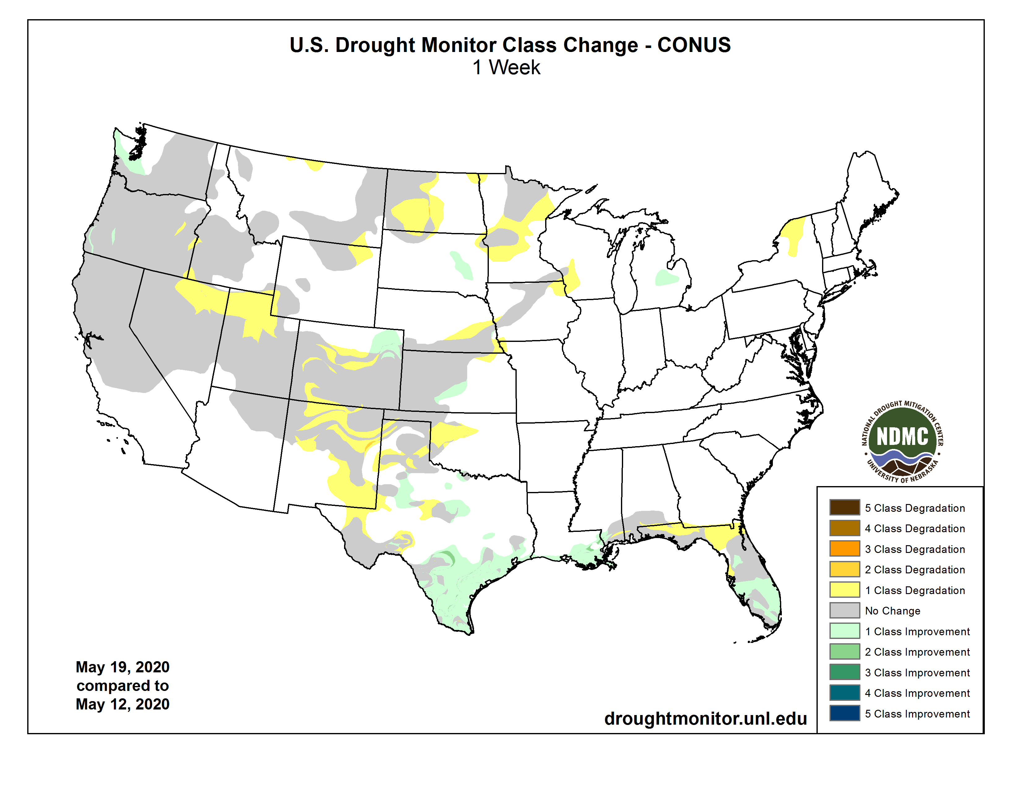
US Drought Monitor one week change map ending May 19, 2020.
Addressing flood risk after an area has already developed is complicated, expensive, and messy in every way you can imagine. This video will recap a challenging flood mitigation project that was 20 years in the making and contrast it with the Mile High Flood District’s modern approach to urban stream design – an approach we call High Functioning and Low Maintenance Streams (HFLMS)
Bear River at CR7 near Yampa / 3:30 PM, May 16, 2019 / Flow Rate = 0.52 CFS. Photo credit: Scott Hummer
FromSteamboat Today (Holly Kirkpatrick and Andy Rossi):
For water managers, the onset of spring is signaled by the reactivation of stream gages.
That’s right, the day field technicians awaken the extensive network of flow data collection instruments from their winter hibernation is highly anticipated in the water world. But what does that mean for the non-water nerds who are simply enjoying warmer temperatures? The short answer is a lot, particularly if you enjoy water activities.
Stream gages, operated by the state of Colorado and U.S. Geological Survey, give water managers, agricultural producers, recreationists and emergency managers valuable information needed to coordinate the use of our most valuable natural resource, water. Before stream gages are activated and spring runoff begins, water managers monitor snowpack to forecast river flows.
Snow Telemetry (SNOTEL) is an extensive system of instrumentation extending from the U.S.-Canada border to the southern reaches of Arizona and New Mexico that tracks snowpack data which determines the amount of water that will end up in our rivers, streams, and lakes when temperatures rise.
The Upper Yampa Water Conservancy District incorporates snowpack data and runoff forecasts for the Yampa River to manage the timing of filling Stagecoach and Yamcolo reservoirs, which can be a delicate balance. The forecast products used by Conservancy District are updated on a regular basis by incorporating new snowpack and climate data as it becomes available.
In addition to all this data, real-world observations can be used to improve the usefulness of the forecast products developed by public agencies. Real-world observations made by a robust monitoring network of citizen scientists provide valuable information. Citizen scientists are those who have a close relationship with rivers and streams, including agricultural producers, outdoor enthusiasts and water facilities operators.
Now for the good news, forecasts suggest a healthy average runoff for the Yampa River system and thus far, this year’s early spring runoff in observed streamflow levels has reinforced those forecasts. So round up your boat gear and get ready to enjoy some warmer days. Spring has finally sprung in the Yampa Valley.
And, if your spring is signaled by the end of calving season and the beginning of irrigation season, don’t forget about Upper Yampa Water Conservancy District’s grant program funding diversion infrastructure improvements. Call Holly Kirkpatrick at 970-439-1081 or visit upperyampawater.com/projects/grants for more information.
Holly Kirkpatrick is the communications and marketing manager and Andy Rossi is the district engineer with Upper Yampa Water Conservancy District.
Denver Water’s Youth Education program has an online platform for students to learn about water in Colorado from their homes. The post Learning about water while ‘safer at home’ appeared first on News on TAP.
Click here to read the whole article and for access to the full commentary, footnotes, etc.:
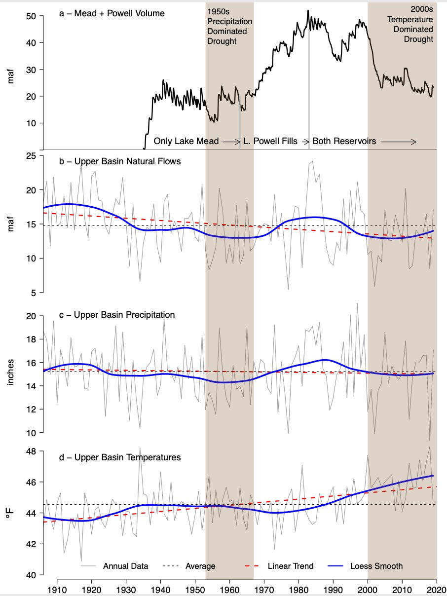
Discussions of droughts and their impacts often center on the lack of precipitation, just as assessments of hydrologic impacts under a changing climate most often focus on how average precipitation in a given locale is likely to change in the future. Within climate science, however, focus has begun to include the growing role warming temperatures are playing as a potent driver of greater aridity: hotter climate extremes; drier soil conditions; more severe drought; and the impacts of hydrologic stress on rivers, forests, agriculture, and other systems. This shift in the hydrologic paradigm is most clear in the American Southwest, where declining flows in the region’s two most important rivers, the Colorado and Rio Grande, have been attributed in part to increasing temperatures caused by human activities, most notably the burning of fossil fuels. Warmer summers are also likely to reduce flows in the Columbia River, as well as in rivers along the Sierra Nevada in California. Now, an important study documents how warming is also causing flow declines in the northern Rocky Mountains and in the largest river basin in the United States, the Missouri. This work further highlights the mechanisms behind the temperature-driven river flow declines and places more focus on how anthropogenic climate warming is progressively increasing the risk of hot drought and more arid conditions across an expanding swath of the United States.
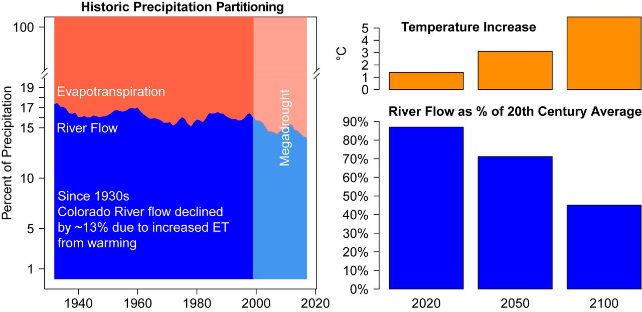
Climate change is causing the Southwest to aridify. (Left) Since the 1930s, increasing temperatures have caused the percentage of precipitation going to evapotranspiration (ET) to increase at the expense of precipitation going to Colorado River flow, resulting in an unprecedented and still ongoing megadrought (shading) starting in 1999. (Right) Higher temperatures have already reduced Colorado River flow by 13%, and projected additional warming, assuming continued high emissions of greenhouse gases, will increase ET while reducing river flow even more through the 21st century. Data on Left are 20-y running means from ref. 5, and data on Right are calculated from Representative Concentration Pathways (RCP) 8.5 multimodel Coupled Model Intercomparison Project–Phase 5 (CMIP5) ensemble temperature increases projected for the Upper Colorado River Basin combined with temperature sensitivity of −9.3%/°C estimated by ref. 5, assuming no change in precipitation. Graphic credit: Jonathan Overpeck/Brad Udall
The work by Martin et al. on the temperature-driven flow reductions in the Upper Missouri River has broader implications. As they note, many aspects of river management could be increasingly impacted by a more arid river basin, including agricultural water deliveries, river management and navigation, and ecosystem services associated with the river; economies of a large region will likely suffer if the aridification continues. This mirrors the change occurring in the Southwest, where rivers provide the only large sustainable water supply to the region and more than 40 million water users, yet flows have already declined significantly since just the late 20th century. Across the US West, warming is also contributing to drier soils, widespread tree death, and more severe wildfires. The recent unprecedented drought conditions in California also have been tied to human-caused warming. Greater aridity is redefining the West in many ways, and the costs to human and natural systems will only increase as we let the warming continue.
Martin et al. also highlight how increasing temperature-driven aridity is more often framed in the West in terms of episodic drought. Just as in the Southwest, where an unprecedented drought began in 1999 and has continued through 2020 with drier-than-normal soils, reduced river flows, and low levels in major reservoirs, the worst drought of the instrumental era gripped the Upper Missouri River Basin between 2000 and 2010. This drought framing is also common among many water and land managers, as well as the public, and implicitly assumes an end to arid conditions must come with the return of rain and snow. However, anthropogenic climate change calls this assumption into question because we now know with high confidence that continued emissions of greenhouse gases into the atmosphere guarantee continued warming and that this continued warming makes more widespread, prolonged, and severe dry spells and drought almost a sure bet. This translates into an increasingly arid Southwest and West, with progressively lower river flows, drier landscapes, higher forest mortality, and more severe and widespread wildfires—not year on year, but instead a clear longer-term trend toward greater aridification, a trend that only climate action can stop.
In the West, declining river flows and soil moisture, as well as more severe wildfires and drought, are now a matter of record. The search for “why” starts with the increasing moisture-holding capacity of the atmosphere. As the atmosphere has warmed, the amount of water vapor in the atmosphere has gone up, consistent with the Clausius–Clapeyron relationship. This, in turn, has increased the demand for moisture by the atmosphere from the land surface and water bodies. Whereas the latter translates to increased evaporation, the former takes place primarily via greater evapotranspiration from soils and vegetation. Soils dry out in a straightforward manner understood by anyone gardening on a hot day, and they dry out faster the warmer it gets. Plants also lose more water to a hotter atmosphere through the small pores (stomata) in their leaves. Although plant physiologists have postulated that increased concentrations of carbon dioxide in the atmosphere help plants keep these pores less open and thus retain water, evidence now suggests that this water efficiency gain is often more than offset by greater plant growth owing to the same carbon dioxide increases. It makes sense that longer growing seasons enabled by warming temperatures mean more total evapotranspiration, drier soils, and reduced river flows.
Martin et al. showcase additional processes likely implicated in the observed aridification in the West. Warming is leading to more rain, rather than snow; a reduction in snowpack; and thus a reduction in surface reflectivity (albedo), further increasing warming, evaporation, and evapotranspiration. Others have focused on yet more ways warming can reduce river flows and soil moisture. Once there is too little water in soil and vegetation to continue evapotranspiration, solar radiation has a bigger warming impact on the atmosphere—the cooling effect of evaporation can no longer do its job, and excess heat can accumulate in ways that amplify the warming and the drying impact of the warming (15).
The impact of warming on the West’s river flows, soils, and forests is now unequivocal. Will higher precipitation save the day? It is true that precipitation is increasing in many regions outside the Southwest, but as in the past, there will always be dry spells and droughts throughout the West and across the High Plains, as well as in eastern North America (16). Importantly, during these dry periods, some lasting just weeks in the summer and some lasting years like the High Plains “Dust Bowl” drought of the 1930s, the full impact of warming temperatures will be fully felt without the relief of increased rainfall. The net result of these more frequent and severe hot–dry events translates into a climate that can manifest increasing aridity and extreme event impacts, particularly in summer, even if the mean annual climate paradoxically becomes wetter in response to anthropogenic climate change.
Increasing aridity is already a clear trend in the West, but greater aridity is also expanding its reach eastward with continued warming. Recent exceptional “flash droughts” in 2012 and 2017 on the High Plains of the United States and Canada, as well as the Dust Bowl drought of the 1930s, highlight how extreme spring and summer temperatures can speed the onset, and worsen the impact, of dry spells and droughts. Climate change farther east, in the Midwest, also means that summer dry spells will tend not only to become hotter but also to lengthen. It is no surprise that irrigated agriculture is expanding eastward in response to climate warming. Perhaps most troubling is the growing co-occurrence of hot and dry summer conditions and the likely expansion, absent climate change action, of these hot–dry extremes all of the way to the East Coast of North America, north deep into Canada, and south into Mexico. It is no surprise that the boreal forest of Canada is starting to show a substantial increase in wildfire and a related net increase in carbon emissions to the atmosphere.
“Aridity” means many things to many people, but at its core it means extreme dryness of the kind that can have serious impacts on humans and the natural systems upon which they depend. Climate change, and in particular warming, will continue as long as humans burn fossil fuels or otherwise increase the concentrations of greenhouse gases in the atmosphere. This is known with high scientific confidence and means that the warming that is already driving an increase in aridity in many parts of North America is sure to continue and expand geographically until climate warming ceases. In the southwest United States and adjacent Mexico, the implications are dire for water security and ecosystems. More severe extreme heatwaves and dust storms are also already occurring, and these and other impacts of aridity will only increase until the cause is halted. Across North America, greater aridity is being offset with increased groundwater use, but this strategy has limits in the many places, such as the Southwest and the High Plains, where groundwater use exceeds recharge and is thus unsustainable.
Other parts of North America likely will not see the widespread aridification and decadal to multidecadal droughts of the West, but will nonetheless continue to see more frequent and severe arid events—extreme dry spells, flash droughts, and interannual droughts will become part of the new normal. Even in many places where mean annual precipitation is increasing, there will be an increase in aridity and the deleterious impacts that come with this increase. The good news is that we know the cause of expanding aridification. Unfortunately, climate change and this aridification are likely irreversible on human timescales, so the sooner emissions of greenhouse gases to the atmosphere are eliminated, the sooner the aridification of North America will stop getting worse.
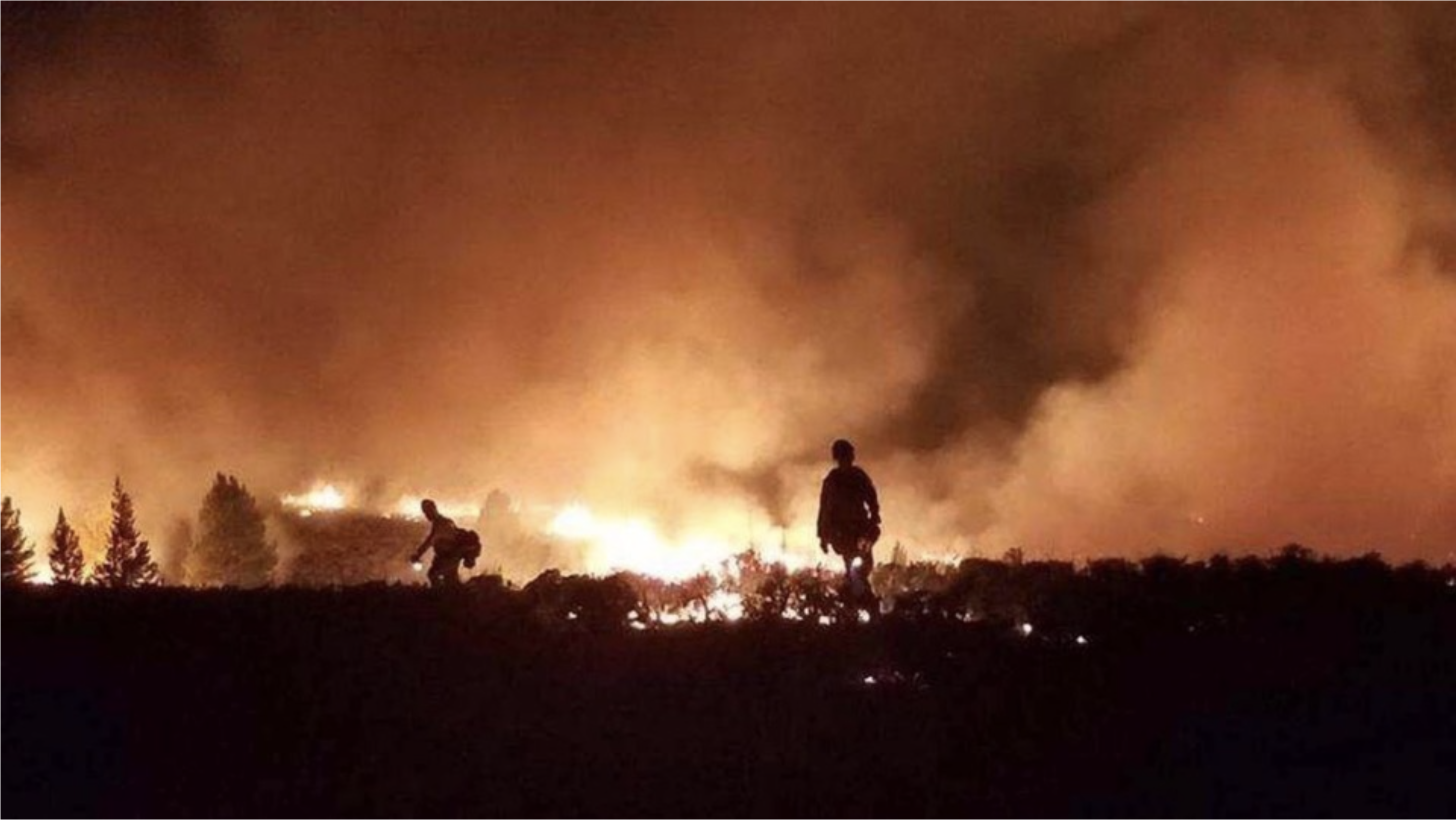
Firefighters work to contain the Ryan Fire in northern Colorado on Wednesday, Oct. 3, 2018. Photo credit: USFS via Firehouse.com
FromAspen Public Radio (Elizabeth Stewart-Severy):
Local governments, the U.S. Forest Service and the Bureau of Land Management each implemented fire restrictions in April in an attempt to prevent further taxing first responders and firefighters.
“The last thing we need right now, with COVID-19, is a wildfire,” [Valerie] MacDonald said, noting that crews have to congregate to effectively fight fires. If even one firefighter has the coronavirus, the disease could spread rapidly…
Wildland firefighters with the Upper Colorado River Fire Management Unit, a combined fire organization for the Forest Service and BLM that covers the White River National Forest, have made changes in light of the pandemic.
Lathan Johnson, a manager with UCR, said it is moving to radio briefings and virtual briefings. But wildland firefighting is a hazardous job, and trying to be mindful of social distancing guidelines adds an extra hurdle…
So far, the UCR unit has not had a positive case of COVID-19. The team is developing contingency plans and protocols to plan for cases. But there isn’t a system for testing in place and many firefighters are still living in bunkhouses…
Johnson said wildland firefighters across the country are working together to share information and best practices, mostly through a website called Wildland Fire Lessons Learned. Firefighters share experiences and ideas, such as a recent post about how a fire unit in Michigan responded to a crew member’s COVID-19 diagnosis by tracing contacts and encouraging exposed team members to get tested.
Wildland firefighting uses a national system that dispatches and moves resources — including firefighters and the specialized equipment they use — across the country to respond to the most dangerous and pressing fires. That presents an additional risk of potential exposure to COVID-19 as fire crews travel across the country and set up camps in new communities…
If a large wildfire caused evacuations in Pitkin County, MacDonald said the county would typically work with the American Red Cross to set up evacuation centers for affected residents. During the Lake Christine Fire, the Red Cross set up a shelter at Basalt High School.
But this year, “we wouldn’t do that,” said Courtney Strother, a disaster program manager for the Red Cross in western Colorado. Traditional evacuation shelters in gyms or large cafeterias make social distancing — and limiting the spread of disease — challenging.
In light of COVID-19, Strother said the best option is to evacuate residents to hotels. Red Cross volunteers across the region are reaching out to hotels to inquire about availability through the fire season…
It might also be possible to use dorms at nearby colleges or cabins at campgrounds that still provide private areas for evacuees. Strother said the Red Cross is also developing plans in case a congregation shelter such as a gym is the only option.
MacDonald said citizens need to do their own planning ahead of fire season, too.
“We definitely want people to take advantage of this time at home,” she said. “With all the extra time everyone’s got, be planning. Be working on their emergency plan: What are their evacuation routes? What would they take? What’s their communication plan with their family?”
People can also work on wildfire mitigation near their homes by clearing brush and other flammable materials.
Discussions of drought often center on the lack of precipitation. But among climate scientists, the focus is shifting to include the growing role that warming temperatures are playing as potent drivers of greater aridity and drought intensification.
Increasing aridity is already a clear trend across the western United States, where anthropogenic climate warming is contributing to declining river flows, drier soils, widespread tree death, stressed agricultural crops, catastrophic wildfires and protracted droughts, according to the authors of a Commentary article published online May 19 in Proceedings of the National Academy of Sciences.
At the same time, human-caused warming is also driving increased aridity eastward across North America, with no end in sight, according to climate scientists Jonathan Overpeck of the University of Michigan and Bradley Udall of Colorado State University.
“The impact of warming on the West’s river flows, soils, and forests is now unequivocal,” write Overpeck, dean of the U-M School for Environment and Sustainability, and Udall, senior water and climate scientist at Colorado State. “There is a clear longer-term trend toward greater aridification, a trend that only climate action can stop.”
The Commentary article responds to a PNAS paper, published May 11 by Justin Martin of the U.S. Geological Survey and his colleagues, that showed how warming is causing streamflow declines in the northern Rocky Mountains, including the nation’s largest river basin, the Missouri.
The Martin et al. study used tree-ring records to analyze the 2000-2010 Upper Missouri River Basin drought and concluded that “recent warming aligns with increasing drought severities that rival or exceed any estimated over the last 12 centuries.”
The study details the mechanisms of temperature-driven streamflow declines, and it “places more focus on how anthropogenic climate warming is progressively increasing the risk of hot drought and more arid conditions across an expanding swath of the United States,” according to Overpeck and Udall.
The Martin et al. study also highlights the way temperature-driven aridity in the West is typically framed in terms of episodic drought. Many water and land managers, as well as the general public, implicitly assume that when returning rains and snowfall break a long drought, arid conditions will also fade away.
But that’s a faulty assumption, one that ignores mounting evidence all around us, according to Overpeck and Udall.
“Anthropogenic climate change calls this assumption into question because we now know with high confidence that continued emissions of greenhouse gases into the atmosphere guarantees continued warming, and that this continued warming makes more widespread, prolonged and severe dry spells and droughts almost a sure bet,” they write. “Greater aridity is redefining the West in many ways, and the costs to human and natural systems will only increase as we let the warming continue.”
Anticipated impacts in the Upper Missouri River Basin mirror changes already occurring in the Southwest, where the trend toward warming-driven aridification is clearest.
Rivers in the Southwest provide the only large, sustainable water supply to more than 40 million people, yet flows have declined significantly since the late 20th century. Declining flows in the region’s two most important rivers, the Colorado and the Rio Grande, have been attributed in part to increasing temperatures caused by human activities, most notably the burning of fossil fuels.
Multiple processes tied to warming are likely implicated in the observed aridification of the West, according to Overpeck and Udall. For starters, warmer air can hold more water vapor, and this thirsty air draws moisture from water bodies and land surfaces through evaporation and evapotranspiration—further drying soils, stressing plants and reducing streamflow.
But the atmosphere’s increased capacity to hold water vapor also boosts the potential for precipitation; rain and snow amounts are, in fact, rising in many regions of the United States outside the Southwest. However, the frequency and intensity of dry spells and droughts are expected to increase across much of the continent in coming decades, even if average annual precipitation levels rise, according to Overpeck and Udall.
“Perhaps most troubling is the growing co-occurrence of hot and dry summer conditions, and the likely expansion, absent climate change action, of these hot-dry extremes all the way to the East Coast of North America, north deep into Canada, and south into Mexico,” they write.
“Other parts of North America likely won’t see the widespread aridification and decadal to multi-decadal droughts of the West, but will nonetheless continue to see more frequent and severe arid events—extreme dry spells, flash droughts and interannual droughts will become part of the new normal,” according to Overpeck and Udall.
“Unfortunately, climate change and this aridification are likely irreversible on human time scales, so the sooner emissions of greenhouse gases to the atmosphere are halted, the sooner the aridification of North America will stop getting worse.”
Video captures the power of water under pressure and the importance of Denver Water’s 24/7 emergency response. The post Main break creates impressive geyser appeared first on News on TAP.
Dillon Reservoir in Summit County is the largest reservoir in the Denver Water system, holding more than 257,000 acre-feet of water when it’s full. With two outlets — the Blue River and Roberts Tunnel — Denver Water officials say it’s complicated to operate. Photo credit: Denver Water via Aspen Journalism
Denver Water officials increased the release of water from Dillon Reservoir into the Blue River to about 400 cubic feet per second in the first week of May as inflow held steady at about 500 cfs through Monday, May 11. The latter number is expected to steadily rise as spring runoff picks up.
The current forecast from the National Oceanic and Atmospheric Administration’s Colorado River Basin Forecast Center estimates as of May 11 that there is 146,000 acre-feet of water — in the form of snowmelt — that will flow into Dillon Reservoir through July 31. There’s currently 17,500 acre-feet of space in the reservoir, according to Denver Water, so about 128,500 acre-feet will flow out of the reservoir either to the Blue River or Roberts Tunnel by July 31, with an estimated 13,000 acre-feet through the tunnel.
All of these complex calculations are the first steps in a delicate dance Denver Water performs each spring to balance public safety with Denver’s water needs, recreation, hydroelectric demands and obligations to downstream senior water-rights holders.
“Dillon is our biggest reservoir and one of our more complicated to operate,” said Nathan Elder, water resources manager for Denver Water. “Most of our other reservoirs only have one outlet, but Dillon’s got both the outlet to the Blue and the outlet to the Roberts Tunnel, which provides water to the East Slope and down the North Fork (of the South Platte River) to Strontia Springs Reservoir and then to our customers.”
The Roberts Tunnel, finished in 1962 about the same time the old town of Dillon was relocated to its current spot and the Dillon Dam was built, is a 23-mile concrete conduit that diverts water from the Blue River basin on the Western Slope to the South Platte Basin on the Front Range to supply more than 1.4 million Denver Water customers.
Colorado transmountain diversions via the State Engineer’s office
This system is what’s known as a transmountain diversion — one of many that bring water from the Colorado River basin on the west side of the Continental Divide to the state’s population center on the Front Range. What it’s not, Elder said, is a way to avoid dangerous spring-runoff flooding.
“We can’t use Roberts Tunnel as a flood-control option,” he said. “So we’re very careful about the amount of water we take from the West Slope over to the East Slope. And when we use the Roberts Tunnel, we can only take it over to the East Slope if it’s put towards the demand. We can’t just dump it over there to prevent flooding or high flows below Dillon.”
The 2014 Colorado River Cooperative Agreement places a 400,000 acre-foot limit on Blue River water stored in existing or future Denver Water storage facilities on the Front Range.
There are more than 1,000 properties in regulatory floodplains in Summit County, according to the Federal Emergency Management Agency, and quite a few of them are along the Blue as it makes its way northwest through Silverthorne and toward its confluence with the Colorado River near Kremmling.
The Blue River travels north-northwest through Dillon Reservoir to its confluence with the Colorado River near Kremmling. Each spring Denver Water performs a delicate balancing act to accommodate flows from snowpack runoff. Photo credit: Denver Water via Aspen Journalism
Snowpack melting
This time of year, as snowpack begins to melt into local tributaries — the Blue, Snake River and Tenmile Creek all feed Dillon Reservoir from the south — Elder and his team closely monitor snowmelt forecasts and weather reports to coordinate with local officials to prevent flooding.
“Denver Water has worked with the town over the years to release water from Dillon Reservoir at rates between 50 cfs and 1,800 cfs,” said Tom Daugherty, Silverthorne’s director of public works. “They have done a very good job of doing that. Denver Water attends our local meetings concerning snowmelt runoff and inform us of what they expect.”
FEMA designates 2,500 cfs as a 10-year flood level just below Dillon Dam, while 3,350 cfs there would be a 100-year flood level. The amount of runoff pouring into the reservoir varies widely, depending on weather conditions and snowpack, from a low inflow of 410 cfs in the drought year of 2012 to a high of 3,408 cfs in 1995.
The amount of snowpack on the Front Range and rate of melting due to high temperatures or rain events also impacts when Denver Water turns on the Roberts Tunnel and how much water it takes out of Dillon Reservoir. The Blue River Decree dictates that Denver Water needs to keep as much water on the Western Slope as possible and can take water only to meet demand.
“Last year was a good example of that,” Denver Water spokesman Todd Hartman said. “We had so much snowpack on the Front Range that we just didn’t need the Roberts Tunnel water and couldn’t take it because of that demand issue.”
That resulted in higher flows on the Blue below the dam last runoff season.
“It got up to around 1,900 cfs, and we didn’t actually turn on the Roberts Tunnel until the second week in August last year,” Elder said. “That’s after everything on the East Slope filled, and we started dipping into that storage and streamflow dropped off on the East Slope.”
This year, there’s a similarly healthy snowpack above the reservoir and also decent snowpack on the Front Range, but temperatures have been higher and the spring runoff season hasn’t been nearly as wet and cool as last year.
“We have a Snotel (snow telemetry) site on top of Hoosier Pass, which is extremely important for monitoring that basin and for forecasting, and it’s still at 121% of normal right now,” Natural Resources Conservation Service hydrologist Karl Wetlaufer said in early May. “It looks like it did actually have a net accumulation through April and is just really just starting to turn around and melt out now over the last few days with this warm weather.”
The Natural Resources Conservation Service produces snowmelt forecasts used by Denver Water, which also taps into the National Oceanic and Atmospheric Administration forecast center.
Based on information from Snotel sites, snowpack above Dillon Reservoir peaked at 127% of normal. The forecast center’s inflow outlook for Dillon Reservoir is 104% of average, and the forecast from the Natural Resources Conservation Service was 107% of average.
The first priority for Denver Water is to fill the reservoir to meet customer needs, but it also tries to minimize high flows out of the reservoir via the Blue River and maintain water levels so that the Frisco and Dillon marinas can operate from June through Labor Day. Elder said the minimum operating level for both Dillon and Frisco marinas is 9,012 feet in elevation.
The goal, Elder said, is to get the reservoir to that level or higher by June 12. On May 11, the surface level of the water in the reservoir was at 9,010 feet. The reservoir is full when the elevation of the water, as measured on the dam, is 9,017 feet, which is 257,304 acre-feet of water. At 9,010 feet, the reservoir is holding about 236,232 acre-feet of water.
Release too much and too early — to avoid high flows and flooding downstream — and Denver Water runs the risk of missing the chance to fill Dillon for use by its customers later in the summer season as well as keep the reservoir full for a long boating season. And then there are the downstream hydroelectric factors and calls by senior water-rights holders.
An inspection team leaving the 23-mile Roberts Tunnel east portal in Park County in 2016. The tunnel, which diverts water from the Blue River to the Front Range is inspected every five years. Photo credit: Denver Water via Aspen Journalism
Senior water rights
While the Blue River Decree does not have a volumetric limit on how much water Denver Water can take out of Dillon Reservoir through the Roberts Tunnel to meet its customer needs, the Roberts Tunnel right is from 1946 and is junior to Green Mountain Reservoir and Shoshone Power Plant rights, which limit the ability of Denver Water to divert. The Roberts Tunnel right is for 788 cfs, which is not a storage right but instead a direct-flow right.
So if Green Mountain gets toward the end of its fill season and hasn’t filled and Dillon has diverted, then Denver Water owes water to Green Mountain. Green Mountain Reservoir, located on the Blue River in northern Summit County, was created specifically to compensate the Western Slope for diversions to the Front Range as part of the Colorado-Big Thompson Project.
Then on the Colorado River in Glenwood Canyon, well downstream from where the Blue feeds the Colorado at Kremmling, there’s Xcel Energy’s Shoshone Generating Station hydroelectric plant — which has one of the most senior water rights on the main stem of the Colorado River. A 1902 right draws 1,250 cfs of water downstream to meet the plant’s needs. During dry times of the year, such as late summer, the power plant often places a “call” on the river, meaning junior diverters upstream — including Denver Water — must stop diverting so that Shoshone can get its full allocation of water.
Elder said Denver Water wants to fill Dillon Reservoir quickly enough each spring before any potential Shoshone call. If a call came before Dillon was full, Denver Water would have to release water from Williams Fork Reservoir in order to keep water in Dillon Reservoir. However, Williams Fork can hold only 96,000 acre-feet of water.
“We want (both reservoirs) to fill quick enough that we fill both before that Shoshone power plant call comes on and before the senior call comes on the river, but not too quick that we fill before peak runoff where we get in those high-flow situations,” Elder said. “So it’s a real balancing act there. You’re balancing elevations for marinas, downstream water rights, filling the reservoir safely and then also any potential releases you may need to make from Roberts Tunnel.”
Aspen Journalism, a 501(c)(3) nonprofit organization supported by its donors and funders, covers water and rivers in collaboration with the Summit Daily News and other Swift Communications newspapers. This story ran in the May 17 edition of the Summit Daily.
A promise of support from the Land and Water Conservation Fund bolsters the year-long campaign to protect the Garfield County lake and its surrounding acres from development
After a year-long campaign to acquire and protect the lake and surrounding acreage in the shadow of the Flat Tops Wilderness, the Forest Service ranked the Sweetwater Lake acquisition ninth among 36 projects and asked for $8.5 million in support from the Land and Water Conservation Fund…
For almost four decades, a rotation of six deep-pocketed owners floated big plans for the 488-acre property. They dreamed up a golf resort, private mansions and even a water-bottling plant.
Coulton Creek Capital in Greenwood Village took over the property when a Castle Rock entrepreneur’s 12-year plan to bottle and sell “Vaspen” water from a local spring evaporated. Coulton Creek listed the property in 2017 for $9.3 million.
The Conservation Fund in 2018 approached Coulton Creek Capital with a proposal to buy the property for protection. The investment firm welcomed the idea and is under contract with the fund in a deal set to close this summer.
The fund borrowed some money from Great Outdoors Colorado to support the acquisition, with the plan to transfer the property to the White River National Forest.
Federal lawmakers still need to discuss Land and Water Conservation Fund support for the Forest Service’s list of priority projects for $87.1 million worth of land acquisition. The list includes 36 ranked projects and the Sweetwater Lake property is the largest request at $8.5 million.
“While the list looks really favorable, we are paying close attention to the budgeting process,” said Justin Spring with The Conservation Fund’s Colorado office. “We are a far cry from having money in hand, but we are excited with the momentum we are seeing.”
Acquisition is only the first step in a longer plan for Sweetwater Lake. The Forest Service wants to improve a deteriorating campground that doesn’t quite reach the water’s edge. The property needs investment to host the expected increase in visitors that will come if the land around the lake is open to the public.
FromThe Associated Press via The Grand Junction Daily Sentinel:
The agency’s list released last week ranked the purchase in Garfield County ninth among 36 land acquisition projects.
The forest service requested $8.5 million from the federal Land and Water Conservation Fund…
The Sweetwater Lake property is the largest request on the forest service’s $87.1 million list of priority projects.
“What often makes these things successful, in addition to being appropriate parcels, is having broad-based support and that is something we feel really good about,” White River National Forest Supervisor Scott Fitzwilliams said. “We have a wide range of governments, agencies and groups supporting this.”
Fitzwilliams hopes to partner with Colorado Parks and Wildlife to improve and maintain a campground and boat launch at the property if federal funding is approved.
Beginning in 2021, the Bureau of Reclamation will repair El Vado Dam.
Built in 1935, the dam is one of the only steel faceplated dams in the country. It can store around 200,000 acre-feet of water.
Some of the steel faceplates of the dam have become cracked and bent due to shifts in the land around the dam, wrote Bureau of Reclamation Public Affairs Specialist Mary Carlson in a March 6 email.
The shifts in land have also caused erosion behind the faceplates and cracks and bending in the plates on the dam’s spillway, she wrote.
Bureau of Reclamation Civil Engineer Carolyn Donnelly discussed the potential effects of these changes at the Fifth Annual Rio Chama Congreso Feb. 29.
“The spillway, some of those face plates, if you walk on it, you can hear it’s kind of hollow underneath and they move, so if we started using that at the full capacity, water could get under those plates, take them out, and then there could be failure of the dam,” Donnelly said. “And luckily there’s not a large population downstream, but for those who are there it would not be a good thing.”
El Vado stores water for irrigation in the Middle Rio Grande Conservancy District, which includes six pueblos—Santa Ana, Kewa, Cochiti, San Felipe, Isleta and Sandia.
It also sometimes stores drinking water for cities including Santa Fe and Albuquerque as part of the San Juan-Chama Project.
Carlson wrote that the Bureau of Reclamation is still working out details about how water will be stored and move during the repair, for which the reservoir will be close to empty for at least a year.
New Mexico Lakes, Rivers and Water Resources via Geology.com.
The Water Main, a project from American Public Media, wanted to know how Americans think, feel and worry about their water. Among their findings is that knowledge of water issues isn’t the biggest predictor of whether someone takes the effort to act. Personal connections to particular rivers, lakes and oceans led to more concrete conservation measures.
“The big surprise is that knowledge, how much we know, and action aren’t as tightly correlated as we might think they are,” said Amy Skoczlas Cole, Water Main’s managing editor. “It wasn’t actually the people who knew the most about water who were doing the most, it was the people who felt the most connected to water who were taking the most action.”
Half of those surveyed reported feeling a strong personal connection to a river, lake, ocean or other body of water.
More people over the age of 65 felt this way than those under the age of 45, the survey found…
The survey also found geographic and regional differences in how people think about water. Residents of Western states were more likely than the rest of the country to vote with water issues top of mind, but knew less about sources of water pollution than those in the Northeast or Midwest.
Western respondents were also twice as likely to say that water was too heavily regulated than those in eastern regions of the country.
Westerners were more likely to share information about water with others. 44% of western residents said they share information about water and water related issues at least once a month, which was the highest of any group surveyed.
The survey aimed to measure attitudes and perceptions about water. It looked at four specific dimensions: how much people know about water, how much they care, how concerned they are and their actions to protect water…
The survey is titled Water + Us, and it was compiled by the APM Research Lab and the Water Main.
[Snowpack] in the Arkansas and Rio Grande basins [was] near normal this year. That snow was not enough to relieve the on-going drought. Runoff in both basins is expected to be well below normal and looks to be coming early. Warm temperatures and lack of precipitation in April have accelerated the snowmelt. Models indicate the runoff may peak about 2-3 weeks ahead of an average year; the Rio Grande slightly earlier than the Arkansas. Runoff in the Arkansas and Rio Grande basins will be well-below average.
Drought conditions began to develop in the early fall of 2019. Below average rainfall during the summer and into the fall depleted soil moisture and groundwater going into the winter. Those dry soils and groundwater reservoirs are currently absorbing snow melt that would run off in a wetter year.
Forecasts from both the NRCS and the NWS reflected these dry soils and ground water deficits earlier this winter. Water users in the Arkansas River basin are fortunate to have a number of dams available within the system. Snowpack and runoff in 2018-2019 were abundant and some of it remains available in storage.
According to the United States Department of Agriculture, Colorado’s current snowpack is at just 43 percent of where the snowpack was this time last year and 64 percent of the average for this date, despite reaching a peak snowpack at 103 percent of the norm this season. This low snowpack is due to warm temperatures and a dry spring, which has resulted in a faster melt and less snow…
One spot that’s particularly dry is the Upper Rio Grande Basin, which is at 25 percent of the median snow water equivalent as of May 13. This includes spots like Medano Pass, Wolf Creek Summit, and Hayden Pass. The Arkansas River Basin is also lacking quite a bit of snow – currently at 59 percent of the median snow water equivalent on May 13. The Arkansas River Basin includes areas like Saint Elmo, Glen Cove, and Fremont Pass…
While things do seem quite dry right now around the state, the 2018 snowpack was worse, as seen by the yellow line in the graph below.
Colorado Statewide Times Series Snowpack Summary May 15, 2020 via the NRCS.
There was a notably wide gap in snowfall totals from the west side of Denver to the east side this winter, with the east side of the city seeing only about half of the snowfall that the west side received. Consider, for example, Wheat Ridge’s approximately 100 inches of snowfall this winter compared to the 48 inches of snow that Brighton received.
To be clear, most winters feature some sort of noticeable gradient between all sides of the Denver metro area. But as evidenced in part by Boulder’s record-breaking snowfall season, this winter favored the east-facing foothills west of Denver in a perhaps slightly unusual way.
For example: Denver generally saw a slightly above average season’s worth of snowfall (57.6 inches at Denver International Airport, and about 71 inches at the Stapleton Airport weather observation site). This was a generally decent-sized winter (30-year average Denver snowfall: about 50 inches) for the immediate Denver area, but it wasn’t off-the-charts for local standards.
But if you push ever-so-slightly west into the west side of Denver and into the first suburbs on the other side of the city line, like Lakewood and Wheat Ridge, and those seasonal snow totals jumped dramatically. Wheat Ridge saw over 100 inches this winter, while Lakewood saw almost 90 inches of seasonal snowfall.
While there’s typically a gap between the east and west sides of Denver, the fact that the west side of the metro area almost doubled the east side’s snowfall is a bit of a wider spread than usual.
“There weren’t a lot of big synoptic storms that were widespread (in producing more evenly-distributed snowfall),” said Scott Entrekin, a meteorologist at the National Weather Service office in Boulder. “Most of the folks on the plains only had 20 to 30 inches of snow, which is a bit below normal out there. We did have some upslope-heavy storms.”
If you stretch out the geography a bit, the gap gets even wider: Colorado’s Eastern Plains saw only about 20 to 30 inches of snow this winter, below average in most cases. Meanwhile, the foothills west of Denver saw as much as 200 inches worth of snowfall, well above the climatological average there.
This was likely due to a high number of snowstorms that primarily pushed in easterly winds, or ones that strongly favor the foothills and the west side of the Denver area. Because elevation begins its sharp climb just west of Denver, easterly winds are forced to climb with the terrain as well. When air rises, it condenses into moisture…
Traditionally, the wider snowfall gap comes between the south side of the metro area and the rest of the city. The Palmer Divide, the mountainous area between Denver and Colorado Springs that rises up to 7,000 feet in elevation, is typically one of the more significant areas of snowfall across the metro area. The Palmer Divide’s elevation difference and geography is why places like Castle Rock (83.5 inches of snow this winter) and Sedalia (about 80 inches) often wind up with some of the higher seasonal totals over the course of a full winter.
The divide, however, usually relies on a bit more of a northerly component to the winds to bring in both colder and more upslope-dominant winds that’ll rise more efficiently against the east-west orientated range.
But this winter, those Palmer Divide areas actually saw slightly less snowfall than places like Wheat Ridge and Lakewood, and Castle Rock barely half of Boulder’s 152 inches of seasonal snowfall. That’s far from unheard of, but it certainly is a bit unusual, and yet another indicator of the huge snow season that the foothills specifically had.
That led to a big difference in snowfall totals over just a few miles across the Denver area this winter, including slightly below average seasonal amounts for areas just north of the city.
Legislative mandates, plunging costs, but also consumer demand push shift
The rapid shift to renewables has three, and perhaps four powerful guiding forces. First were the legislative mandates to decarbonize electrical supplies. Colorado in 2019 set targets of 50% reduction economy wide by 2030 and 90% by 2040. New Mexico, a second state where Tri-State operates, has comparable goals.
A second and now more powerful driver pushing renewables have been plunging prices.
“It’s no longer just a green movement, it’s an economic movement,” said Duane Highley, chief executive of Tri-State Generation and Transmission, which delivers electricity to 43 member cooperatives in Colorado and three other states.
Tri-State recently signed contracts for 1,000 megawatts of wind and solar energy that will be coming online by 2024 at average price of 1.7 cents per kilowatt-hour.
“That’s an amazing price. That’s lower than anything we can generate with fossil fuels. It automatically gives us the head room, because of the savings just on energy, to accelerate the retirement of coal and do that affordably with no increases in rates,” said Highley. “We see downward rate pressure for the next 10 years, and beyond 2030, we see increases below the rate of inflation.”
The economics prevail in states that have not adopted mandates designed to reduce emissions.
“We see a green energy dividend that allows us to accelerate the closure of coal without raising rates. That’s a key and it’s a key for Tri-State to getting support from our board, which covers four states. Nebraska and Wyoming don’t have the same intensity of passion behind the renewable energy movement that New Mexico and Colorado do. But one thing all of our members can agree upon is low rates and low costs.”
At Holy Cross Energy, an electrical cooperative that is not supplied by Tri-State, chief executive Bryan Hannegan sees the same downward price pressures.
“The price of new power supply from the bulk grid is coming in below where we are today in the marketplace. That is actually putting downward pressure on rates,” he said. At Holy Cross, the cost of electricity accounts for half of what consumers pay, with the other half going to the poles, wires, trucks and overhead.
“We at Holy Cross are saying we will get to 70% clean energy by 2030 with no increase in our power supply costs. If we can do it—which is a big if—we will try to do it in a way that keeps our rates predictable and stable.”
A third driver of the move to renewables has been bottom-up pressure from customers. Both Vail Resorts and the Aspen Skiing Co. have pushed Holy Cross Energy to deliver energy untainted by carbon emissions. So have individual communities. Six of the member communities in Colorado Communities for Climate Action are served by Holy Cross. “That is driving us forward. We are hearing it from our customer base,” said Hannegan.
Yet a fourth driver may be choice, as consumers can demand to pick and choose their energy sources as is proposed in a bill about community choice aggregation introduced in the Colorado Legislature this year. Holy Cross has to deliver that clean energy “frankly before somebody else does.”
All three utilities represented on the webinar retain ownership in coal plants. Holy Cross Energy, however, has consigned the production from its small ownership of Comanche 3, located in Pueblo, Colo., to Guzman Energy. Both Tri-State and Platte River have plans to be out of coal in Colorado by 2030, although Tri-State has no plans yet announced to end importing coal from a coal plant at Wheatland, Wyo.
Portions of the Gila River would be designated as “wild and scenic” under legislation unveiled [May 12, 2020] by New Mexico’s two U.S. senators…
The measure would cover more than 400 miles (644 kilometers) of the Gila River, San Francisco River and numerous creeks. It also calls for expanding the boundaries of the Gila Cliff Dwellings National Monument by transferring management of less than a square mile (1.8 square kilometers) from the U.S. Forest Service to the National Park Service.
The legislation comes as the U.S. Bureau of Reclamation and the New Mexico Interstate Stream Commission gather comments on an environmental review of a proposal to divert and store some of the water.
Environmentalists have been pushing for years to stop any kind of diversion along the Gila, suggesting that siphoning water from the river would end up being a costly boondoggle. Supporters say the project is vital to supplying communities and irrigation districts in southwestern New Mexico with a new source of water as drought persists.
The legislation unveiled by Sens. Tom Udall and Martin Heinrich aims to protect the area’s beauty and wildlife by maintaining the river’s “free-flowing nature.” The Democrats say the measure would preserve private property and water rights as well as irrigation and water delivery obligations, grazing permits and public access.
The senators first floated a draft in February, saying they wanted to hear from landowners, outdoor enthusiasts, local officials and others. Changes include protecting existing uses and language to ensure planned projects like broadband infrastructure development can continue.
Additional protections were included for property owners to prohibit non-voluntary condemnation of land, and a section was added to allow restoration projects even if river values are affected, as long as water quality, habitats and species are protected.
Udall called the Gila an irreplaceable treasure…
Heinrich said protection under the federal Wild and Scenic Rivers Act would be fitting as the landscapes and ecosystems shaped by the Gila and its tributaries inspired the establishment of the nation’s first wilderness area nearly a century ago.
There are nearly 125 miles (200 kilometers) of river segments in New Mexico already designated under the act. Those include parts of the Rio Grande, Rio Chama, Pecos River and the Jemez River.
The fight over the Gila has been percolating for years.
Under the Arizona Water Settlements Act of 2004, New Mexico is entitled to 14,000 acre-feet of water a year, or about 4.5 billion gallons. State officials opted to build a diversion system, as that alternative opened the door to more federal funding.
However, state water officials missed a deadline in December to have an environmental review completed and approved by the federal government in order to free up additional funding.
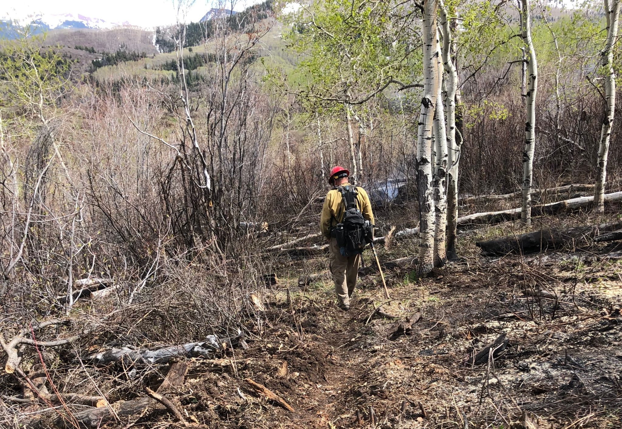
A firefighter walks through the burn area of the Parsnip Fire, which ignited near Carbondale on May 4. Crews took extra precautions in light of the COVID-19 crisis. Photo credit: USFA via Aspen Journalism
Through stay-at-home orders and social distancing, the White River National Forest has remained, mostly, open and popular. Now, Forest Service officials are working out details for housing summer staff and opening campgrounds and recreation areas amid concerns about COVID-19.
Every summer, the White River National Forest brings on more than 100 seasonal employees. Many of them live in tight quarters and bunkhouses, but not this year.
Forest Supervisor Scott Fitzwilliams said the Forest Service is working with limited housing — and seasonal firefighters get first dibs.
“Across the nation, that was the highest priority — making sure we have adequate firefighters, on staff, trained up, ready to go for the fire season, which we really never know when it’s going to be upon us,” Fitzwilliams said.
Fire restrictions are in place across the region to protect the safety of emergency responders during the COVID-19 crisis. Still, an abandoned campfire ignited a small wildfire near Carbondale on May 4. Fitzwilliams said the 15 firefighters and one helicopter that responded to the fire took extra precautions.
“We feel pretty good about where we’re at,” he said. “I think all of us worry about a large incident that requires a team and fire camps and big meetings and briefings.”
As other forests start to deal with larger fires, Fitzwilliams said agency staffers from across the country are sharing information and lessons they’re learning about fighting fires during the COVID-19 outbreak. Fitzwilliams is considering how to use other resources to protect crews.
“Potentially, with things going the way they are, we could use more aircraft,” he said. “Even on smaller fires that maybe we’d send a hand crew out to, we’d just order an aircraft to put it out.”
Seasonal firefighters have arrived and are in training, but many other seasonal workers are delayed until the end of the month or might not arrive at all.
“We’re not going to have as many people, that’s for sure. So we’re just going to have to adjust. Some things that we planned to get done just won’t,” Fitzwilliams said. “Maybe there’s going to be a few less miles of trail cleared by the end of the year, but in the scope of things, that’s not the end of the world.”
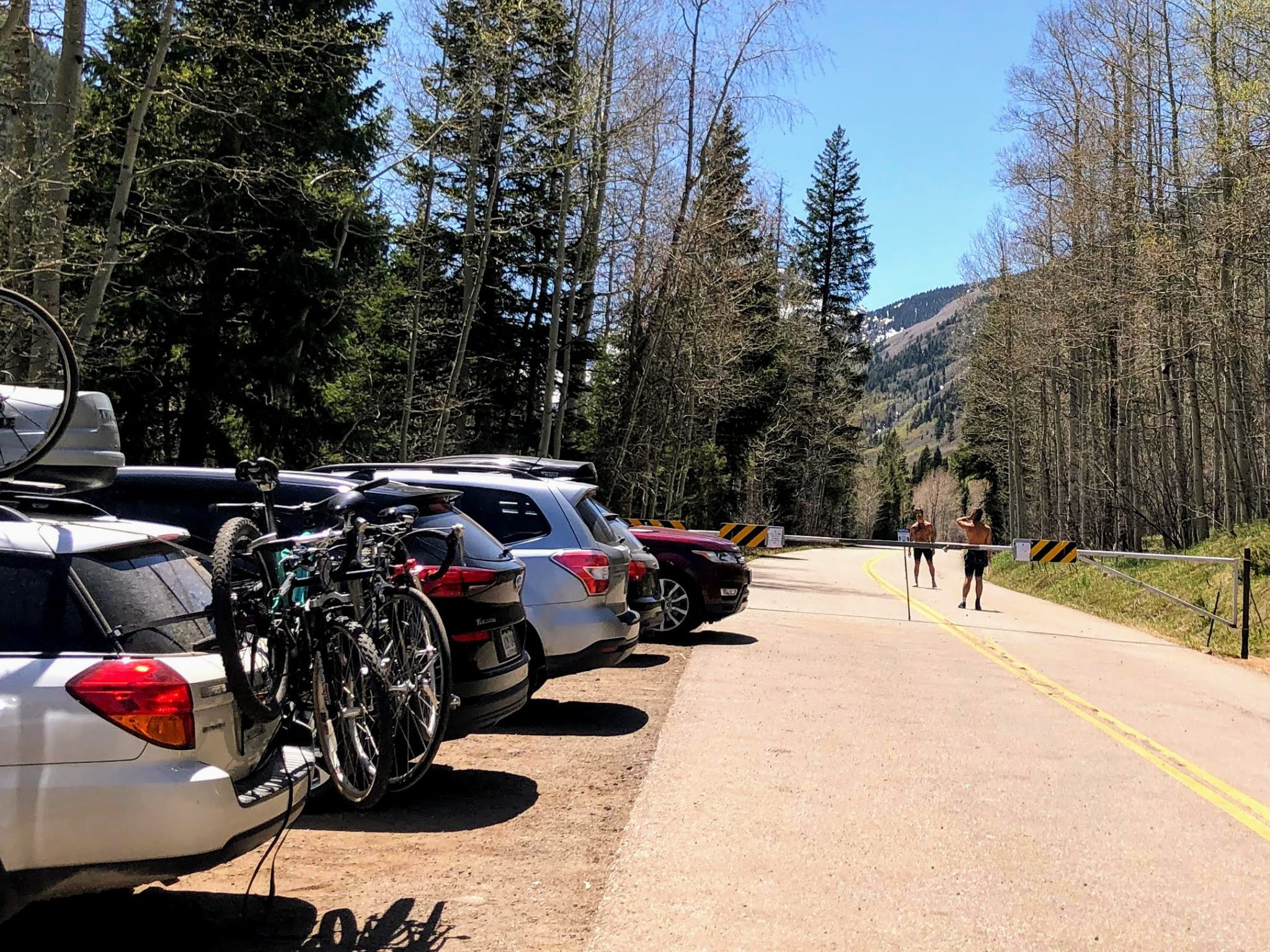
Cyclists pause to throw a frisbee at the winter closure gate on Maroon Creek Road in early May. Officials with the U.S. Forest Service are working on plans for a reservation system for people to drive to the Maroon Bells instead of running shuttles because of COVID-19-related restrictions. Photo credit: Elizabeth Stewart-Severy/Aspen Journalism
Car reservations to replace shuttles
The agency is working on plans to open campgrounds by June 1. That will require clear guidelines for cleaning facilities and might mean closing some spots to ensure ample distance among campers.
Fitzwilliams said the agency is also working on plans to open some of the most popular spots in the White River National Forest, including the Maroon Bells and Hanging Lake, with some changes.
“At least for the foreseeable future, there will be a lot less people up there,” he said.
The Maroon Bells and Hanging Lake both rely on shuttle services, which will probably not run this summer because of social distancing guidelines that limit the number of passengers. If buses can’t run at capacity, it’s not economically feasible to run them, Fitzwilliams said.
“So what we’re looking at — both for Hanging Lake and Maroon Bells — is some sort of reservation program where people can drive their own car there, but obviously it’s limited by the amount of parking for both places,” he said. “We won’t have the numbers, but people will be able to have the experience.”
The Forest Service recently implemented a reservation and shuttle service at Hanging Lake, and Fitzwilliams said the agency is taking care now to avoid the kind of overcrowding that led to that program.
“At Hanging Lake, it was a free-for-all — whoever got to the parking lot first won,” Fitzwilliams said. “And we’re not going to resort back to that.”
Details on reservation systems for visiting the Maroon Bells and Hanging Lake are expected in the upcoming weeks.
Editor’s Note: At a meeting on May 12, Pitkin County officials said bus service was likely to run to the Maroon Bells beginning in early June. The Aspen Times reports here.
Aspen Journalism, a 501(c)(3) nonprofit organization supported by its donors and funders, partners with Aspen Public Radio and The Aspen Times on coverage of environmental issues. This story aired on Aspen Public Radio on May 12.
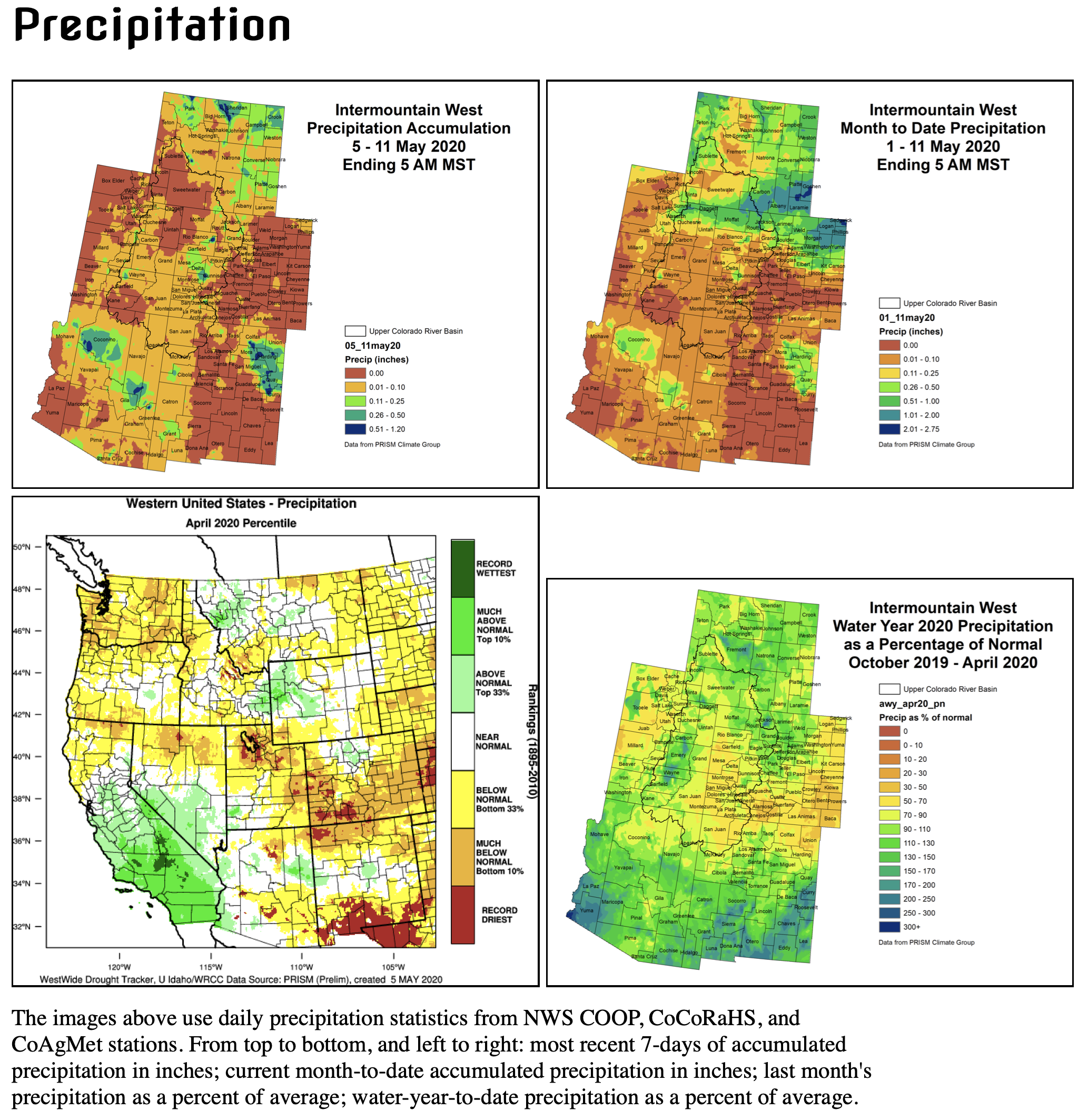
Click here to read the briefing and view the links to the various graphics:
Latest Briefing – May 11, 2020 (UT, WY, CO)
The May climate briefing was posted today on the Intermountain West Climate Dashboard. The May climate briefing, excerpted below, summarizes recent temperatures and precipitation, snowpack and drought conditions, forecasted spring-summer streamflows, ENSO and climate outlooks and significant monthly climate events. Highlights from the briefing include:
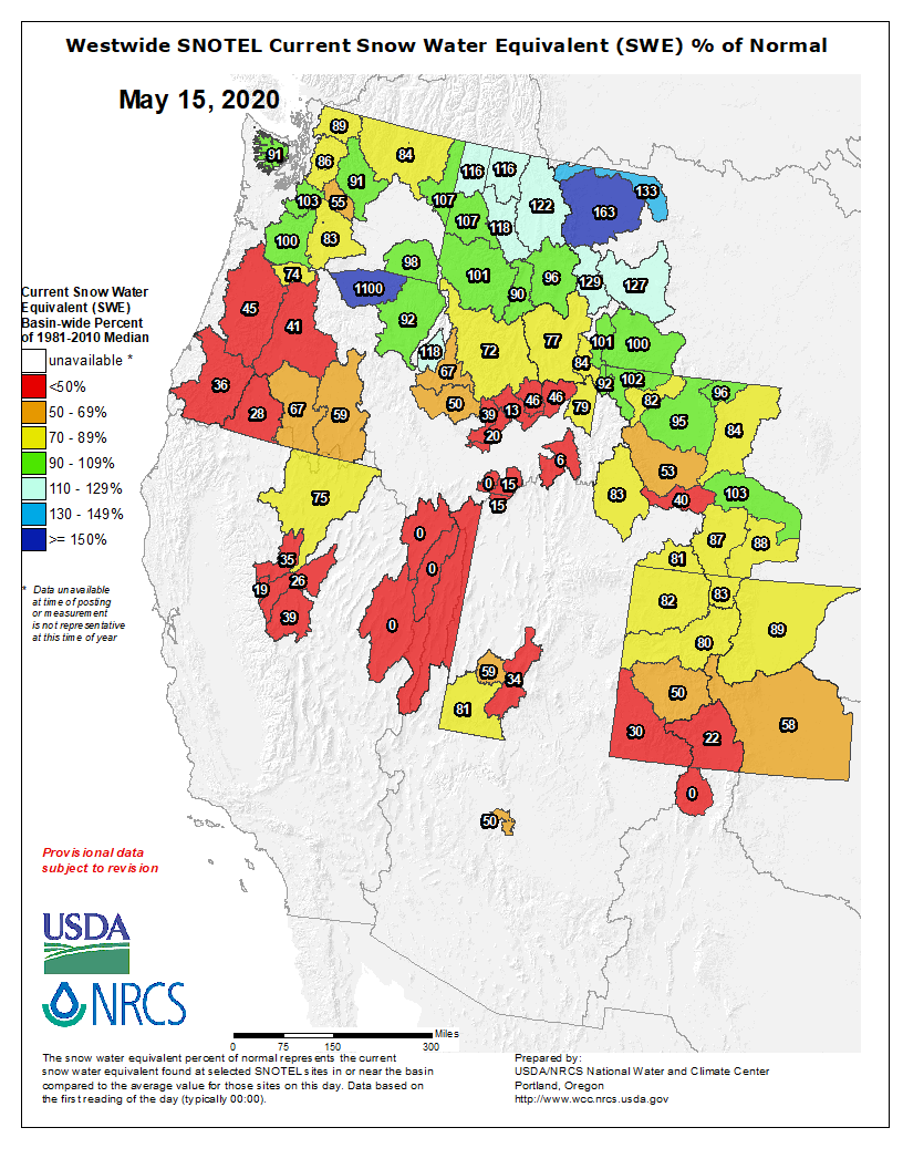
A very dry April in Utah and southern Colorado caused an acceleration of snowmelt, a decrease in forecasted seasonal streamflow volumes and a major expansion of drought in southern and eastern Colorado. While Utah and southern Colorado precipitation was much below average, near-average precipitation and near- to below-average temperatures prevailed in northern Colorado and Wyoming. Snowpack conditions are generally below to much below average in Utah and southern Colorado, but near average in northern Colorado and Wyoming. Regional May 1 seasonal streamflow forecasts are generally below average, with a few basins forecasted to have near-average or much-below-average seasonal streamflow.
April temperatures were generally below average in northern and eastern portions of the region and slightly above average in southern and western portions of the region Western US Seasonal Precipitation. Temperatures in much of Utah during April were slightly above average, while temperatures in Wyoming were below average. Slightly above-average April temperatures in Utah were driven by much-above-average temperatures (10-20°F) during the last week of the month; the first three weeks of April were slightly cooler than average. April temperatures in Colorado were a mix of above average in the southwestern portion of the state and slightly below average in northern and eastern Colorado.
Snowpack conditions across the Intermountain West as of May 4th mainly fall into the below-normal and near-normal categories Western US Snowpack Anomaly. Warm temperatures and below-average precipitation caused snowmelt to accelerate during April in much of Utah and southern Colorado. Snowpack in much of Utah and southern Colorado is 5070% of normal. Northern Colorado and much of Wyoming have near-normal snowpack. The increase in melt of Intermountain snowpack over the last month was driven largely by below normal regional precipitation and exacerbated by very warm temperatures in Utah and southern Colorado during the last week of April.
The NOAA CBRFC May 1st seasonal runoff forecasts for the Upper Colorado River Basin and the Great Basin are generally below average; near-average and much-below-average conditions are forecasted for a few sub-basins Western US Seasonal Precipitation. Near-average seasonal runoffs (90-110%) are forecasted for the Upper Colorado, Upper Green, Virgin and Lower Bear River basins. Below-average seasonal runoff (70-90%) is forecasted for the mainstem of the Colorado, Lower Green and Upper Bear River basins and the Six Creeks basin. Much below-average season runoff (<70%) is forecasted for the Gunnison, San Juan, Sevier and Weber River basins. In general, forecasted runoff volumes have decreased by 10-25% in the Great Basin, largely due to very low April precipitation. The inflow to Lake Powell on the Colorado River is forecasted to be 4.65 million acre-feet (65% average), which is a significant decrease from the April 1st forecast of 5.6 million acre-feet. The NRCS May 1st seasonal runoff forecasts are generally similar to NOAA CBRFC forecasts in the Upper Colorado and Great Basins SWcast. East of the Continental Divide, seasonal streamflow forecasts are near average for the South Platte River basin and below average for Arkansas River basin.
A significant worsening of drought conditions in Colorado was driven by extremely low April precipitation and slightly above-normal temperatures. Total coverage of drought (D0 D2) in Colorado expanded slightly in April, from 68% to 76% WY Drought Monitor. In southern and eastern Colorado, precipitation was only 25% of average with isolated areas receiving less than 5% of normal precipitation. D3 drought emerged in portions of southern and eastern Coorado during April. D2 drought in this region of Colorado also significantly expanded. Coverage of D2 and D3 drought in Colorado was only 3% of the state on March 28th, but expanded to over 40% of the state by May 5th. Total coverage of drought in Utah remained mostly unchanged during April despite low precipitation and warm temperatures. A small area of D2 drought emerged in central Utah during April. D0 drought in Wyoming expanded significantly in the north-central portion of the state and covers 17% of the state.
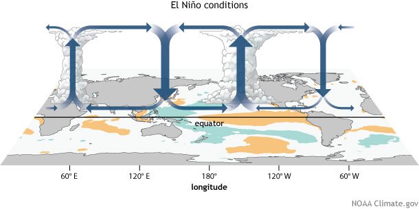
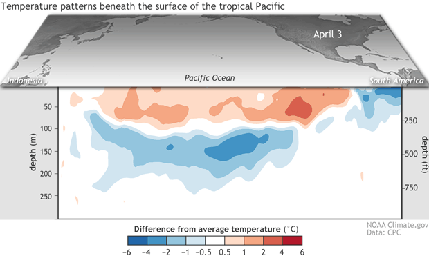
Ocean temperatures in the tropical Pacific Ocean were approximately 0.5°C above normal and ENSO phase was neutral during April ENSO Nino Regions Sea Surface Temperature Anomalies . Tropical Pacific Ocean sea surface temperatures continue to trend towards average ENSO Prediction Plume. During late spring and summer, ENSO is most likely to remain neutral, but by fall there are equal chances of each ENSO phase ENSO Prediction Plume. NOAA one-month precipitation and temperature outlooks show a tilt in the odds towards below-average precipitation 3-mo temp forecast, 0.5-mo lead and above-average temperatures 3-mo temp forecast, 0.5-mo lead for much of the region. The three-month outlook shows no tilt for precipitation and a strong tilt towards warmer-than-normal temperatures for the entire region 3-mo temp forecast, 0.5-mo lead.
Significant weather event for April. Record cold temperatures and snow impacted the Front Range and elsewhere in Colorado from April 11-16. Temperatures on April 13th in Denver dropped to 15°F, breaking the 1933 record of 17°F. On the same morning, temperatures in Grand Junction fell to 19°F, also breaking a 1933 record for that date. The peach crop in western Colorado sustained severe damage from the deep freeze. Light snow fell throughout the Front Range during the cold wave, but heavy snow developed near the foothills in Boulder County where over 30” fell over the five-day period. By the end of the storm cycle, the 2019-2020 winter season had set the record for the snowiest winter in Boulder, CO, with 151.2”, eclipsing the record set in 1908-1909.
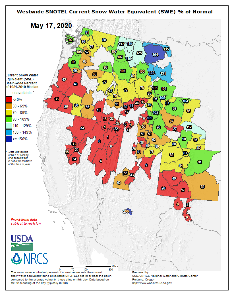
Westwide SNOTEL basin-filled map May 17, 2020 via the NRCS.
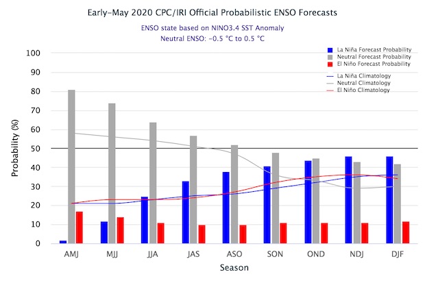
Synopsis: There is a ~65% chance of ENSO-neutral during Northern Hemisphere summer 2020, with chances decreasing through the autumn (to 45-50%).
During April 2020, positive sea surface temperature (SST) anomalies weakened and were near zero by the end of the month. All of the Niño indices decreased during the month, with the latest weekly Niño index values near +0.2°C. Equatorial subsurface temperatures (averaged across 180°-100°W) declined further and were below average, due to the eastward expansion of below-average subsurface temperatures into the eastern Pacific. Also during the month, low-level wind anomalies were easterly across the central and east-central Pacific, while upper-level wind anomalies were westerly over the central and eastern portions of the basin. Tropical convection was near average around Indonesia and suppressed over the Date Line. Overall, the combined oceanic and atmospheric system remained consistent with ENSO-neutral.
The majority of models in the IRI/CPC plume favor ENSO-neutral (Niño-3.4 index between -0.5°C and +0.5°C) through the Northern Hemisphere autumn, though considerable spread is evident at longer lead times. Niño 3.4 index values are expected to decrease through the remainder of the Northern Hemisphere spring and into the summer; with the possibility of below-average temperatures becoming more established toward the latter half of the year. The consensus of forecasters favors ENSO- neutral conditions through the summer and fall, and slightly tilts toward La Niña at the end of the year (~45% chance). There is a ~10% chance of El Niño from the summer through the end the year. In summary, there is a ~65% chance of ENSO-neutral during Northern Hemisphere summer 2020, with chances decreasing through the autumn (45-50%; click CPC/IRI consensus forecast for the chance of each outcome for each 3-month period).
Here’s the release from the Colorado Water Conservation Board:
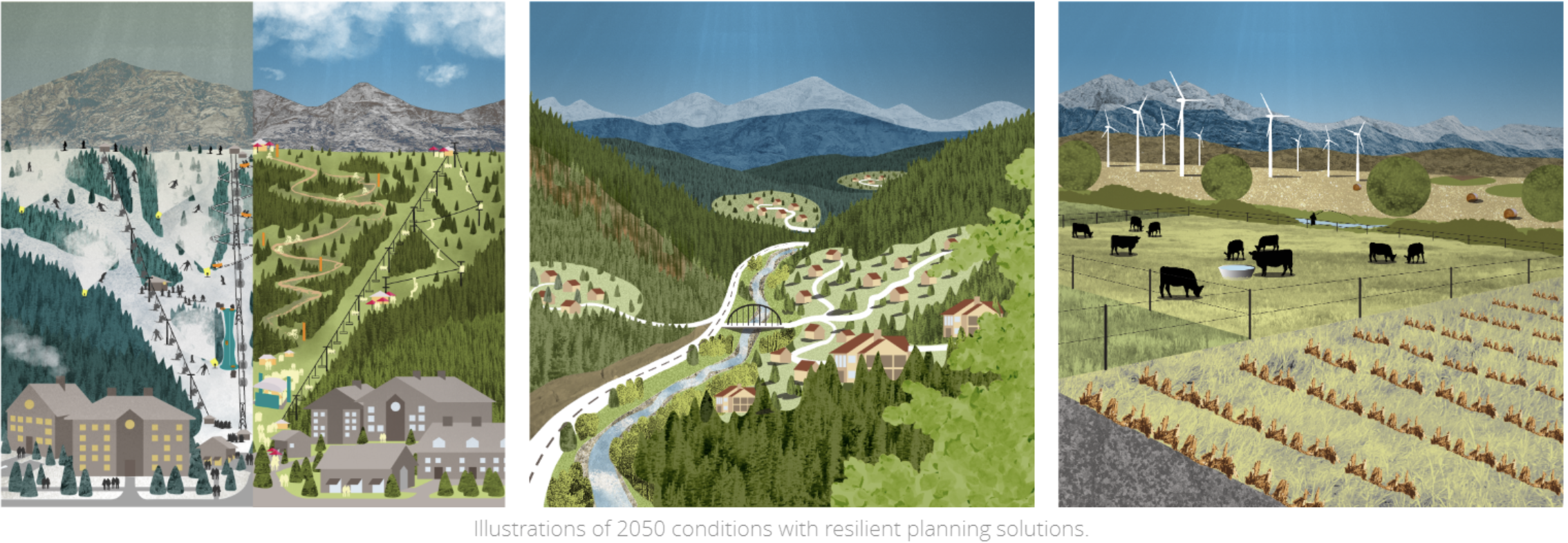
A new state study and web-based visualization tool called Future Avoided Cost Explorer (FACE:Hazards), led by the Colorado Division of Homeland Security and Emergency Management (DHSEM) and the Colorado Water Conservation Board (CWCB) in partnership with the Federal Emergency Management Agency (FEMA), is now available to help communities examine the economic risks of climate change.
FACE:Hazards empowers communities to justify mitigation and adaptation investments using climate and risk-informed decisions.
The FACE:Hazards explorer displays study results as an interactive dashboard to help inform preparedness and resilience policies, support recovery and adaptation investments, and provide decision-makers with tools to quantify the growing cost of inaction.
“This pilot study provides decision-makers with a greater understanding of future economic risks compared to today’s baseline. At its foundation, the Future Avoided Cost Explorer opens new doors for inquiry and examination of how adaptation actions can offset future damages,” said CWCB Senior Climate Specialist Megan Holcomb.
FACE:Hazards measures the current and future impacts from flood, drought and wildfire across multiple sectors of Colorado’s economy. County-level damages are analyzed under current and 2050 climate and population conditions to explore the effects of unmitigated development and increased hazard intensity on certain economies.
The FACE:Hazards tool is important to Colorado because, until now, the State of Colorado did not have a tool to quantify future risk to climate hazards or the potential savings from strategic resilience. By creating this web-based, climate data-informed explorer, local governments can inquire, evaluate, and prioritize investments today to reduce economic vulnerabilities over the next three decades.
After the 2013 Floods, DHSEM received a post-disaster mitigation grant from FEMA to complete a required three-phased update to the State’s Natural Hazard Mitigation Plan.
“The success of this three-phased project was due in part to the dedication of all state agencies involved and our partnership with FEMA Region VIII. This is a testament to promoting a holistic, comprehensive and integrated approach to emergency management and subsequent enhanced mitigation efforts in order to serve all of Colorado,” said Patricia Gavelda, DHSEM Mitigation Planning Team Supervisor and project manager for all three phases.
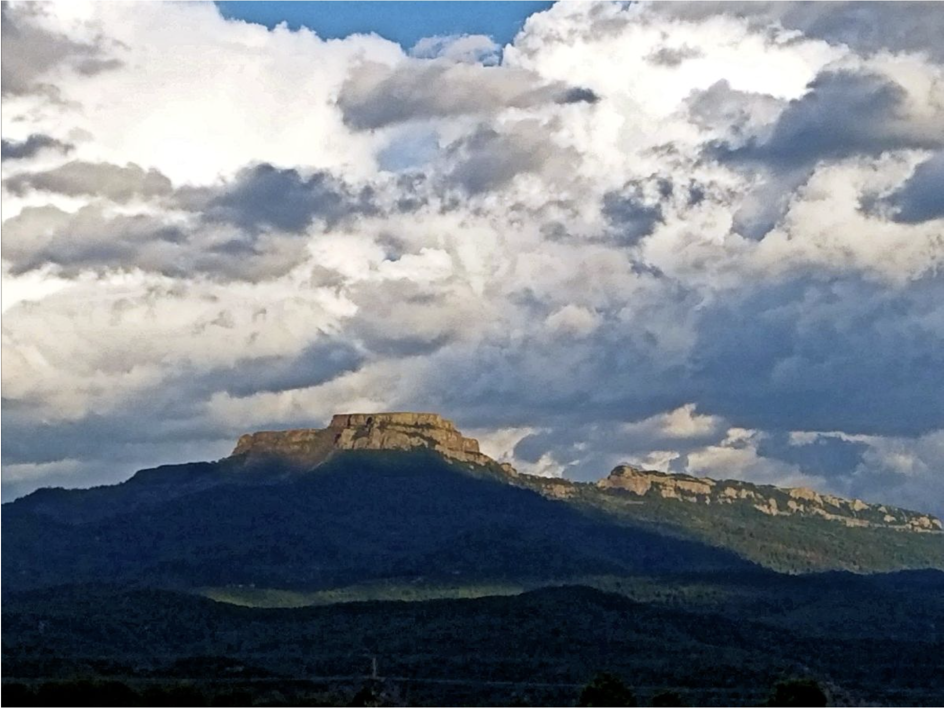
The 9,633-foot summit of Fishers Peak looms over Trinidad. Photo courtesy of Colorado Parks and Wildlife / Bill Vogrin
From email from Colorado Parks and Wildlife (Bill Vogrin):
More than a year after entering a partnership to acquire a 19,200-acre ranch that includes the towering landmark known as Fishers Peak, Colorado Parks and Wildlife has completed the purchase, clearing the way for creation of the state’s 42nd state park.
The acquisition is especially significant as Coloradans prepare to celebrate Colorado Public Lands Day on Saturday, May 16.
“The state’s acquisition of Fishers Peak is an exciting milestone for Colorado outdoor recreationists, wildlife watchers, hunters and residents and businesses of Southern Colorado,” Governor Jared Polis said. “The COVID-19 pandemic has shown that Coloradans highly value their open spaces and outdoor recreation opportunities. Colorado was one of the few states to keep our state parks open during this entire crisis because recreating at a safe space outdoors is a healthy part of our lifestyles. Adding Fishers Peak as our next state park will increase opportunities to explore a unique and stunning part of Colorado.”
“I look forward to celebrating Colorado Public Lands Day this weekend and, in the months to come, opening Fishers Peak to the public with our important partners and local elected officials.”
In February 2019, CPW partnered with the City of Trinidad, The Nature Conservancy, The Trust for Public Land and Great Outdoors Colorado (GOCO) to purchase the mostly undeveloped property, prized for its variety of habitat, wildlife and the linkage it provides between grasslands to the east with foothills and mountains to the west.
The property includes the 9,633-foot summit of Fishers Peak, an iconic outcropping of ancient horizontal lava flows atop Raton Mesa, which has served as a landmark for Native Americans, a beacon for pioneers moving west and a waypoint along the historic Santa Fe Trail connecting the Eastern U.S. to New Mexico and the Southwest.
The Fishers Peak property also is valued for the wildlife it shelters, including native species like elk, mule deer, white-tailed deer, mountain lion and black bear. And it preserves important migration corridors between their populations in the mountains and those on the prairies.
On April 2, the partners signed over ownership of the property to CPW. With the deed in hand, CPW leadership and the partners immediately ramped up master-planning efforts to create a new state park that will protect the natural treasures and wildlife found there while welcoming visitors, including hunters, campers, hikers, mountain bikers, wildlife watchers, rock climbers and other outdoor enthusiasts.
“We are grateful to our partners for all their work securing the property for future generations of Coloradans and visitors,” said Brett Ackerman, CPW Southeast Region Manager. “Great teamwork has gotten us to this point. We at CPW look forward to completing the master-planning process and meeting the governor’s goal of opening Colorado’s next state park.”
“We are pleased to finalize this sale of the property to CPW in these trying times,” said Carlos Fernandez, Colorado State Director for The Nature Conservancy. “Over the past weeks, it’s become even more clear how important access to nature is to all people, providing solace, hope and community. I’m proud of the Conservancy’s efforts with partners to steward this project from the beginning to where we are now, one step closer to Colorado’s next state park.”
“It’s become more evident than ever that access to the outdoors is an important part of everyone’s physical and mental well-being,” said Jim Petterson, The Trust for Public Land’s Colorado state director. “This new state park will give the people of Colorado an exceptional place to get outside to heal and connect with nature, their community and each other.”
“GOCO is a proud partner in this once-in-a-lifetime opportunity,” said GOCO Executive Director Chris Castilian, whose agency provided the bulk of the funding, $17.25 million, toward the acquisition. “It’s been our honor to be a proponent and primary funder of this amazing project to date, and we look forward to supporting our partners at CPW to bring a vision for this state park to fruition.”
“The City of Trinidad strongly supports Colorado Parks and Wildlife’s acquisition of the Fishers Peak property and the partnership that made this new state park a reality for our city and Las Animas County,” said Trindad Mayor Phil Rico.
For now, the property remains closed to public access. But CPW intends a phased approach to opening that will allow limited public access to the property while the master-planning process proceeds and a full state park is developed.
The public can follow the park’s progress and get updates on participating in the planning process at cpw.state.co.us.
In 2016, Colorado became the first state to establish a holiday for our public lands. Colorado Public Lands Day focuses on how our public lands are central to the state’s economy and our quality of life.
The COVID-19 crisis has impacted Colorado’s outdoor recreation economy and we all must adapt and celebrate public lands while remaining socially distant. As a result, Colorado Public Lands Day activities this year will highlight art, film, educational webinars and community conversations to offer a variety of ways that Coloradans can meaningfully connect with one another as well as our precious lands and waters. Learn more about Colorado Public Lands Day here: https://copubliclandsday.com.
Just one week after extreme drought returned to Colorado, the impacted area has expanded in the southern portion of the state according to the United States Drought Monitor. The second worst category of drought had left the state in March 2019 before making its return this month.
In the southeast, extreme drought expanded into Crowley, Lincoln and Cheyenne counties, and increased its presence in Baca, Prowers and Kiowa counties.
For the southern Colorado mountain area, extreme conditions expanded in Saguache, Custer, Huerfano and Las Animas counties.
Severe drought expanded north in central and eastern Colorado, replacing moderate conditions. Moderate drought also gave way to abnormally dry conditions in parts of Pitkin, Chaffee and Gunnison counties.
Colorado Drought Monitor May 12, 2020.
Portions of eastern Colorado received an inch or more of rain early Saturday morning, potentially minimizing further expansion in the coming week.
Sixty-three percent of the state is in moderate, severe or extreme drought, up two percent from the previous week. The worst drought category, exceptional, was most recently recorded in Colorado in February 2019.
Currently, 15 percent of the state is in extreme drought, up four percent from the prior week. Severe drought increased two percent to 31, while moderate drought dropped four percent to 17. Abnormally dry conditions increased from 14 to 17 percent of the state. Just 21 percent of Colorado is drought-free.
One year ago, 11 percent of Colorado was abnormally dry, while the remaining 89 percent was drought-free.
At its regular meeting on May 5, the Pagosa Springs Sanitation General Improvement District (PSSGID) approved a purchase of $73,317 for additional pumps for pump stations.
Pumps were previously pur- chased in December of 2019 and have since been installed, Public Works Director Martin Schmidt explained during the meeting.
Since the installation of those pumps, however, they have seen failures and other issues, Schmidt explained.
The town ultimately got the assistance of its on-call engineer service, RG and Associates (RGA), to further investigate the problem and the town’s lift stations, Schmidt explained…
RGA, through its research, found that a series of things are causing pumps to fail, Schmidt explained.
Currently, staff is looking at prices for swing check valves to replace a ball valve pump control, he explained.
“That is something that really needs to be done no matter what else we do in this phased process because the current system creates a lot of dead head time,” Schmidt described.
According to Schmidt, “dead head time” is where pumps are pumping against a closed valve.
“For any pump system, there is an allowable amount of time that can happen, but because we have two 115 horsepower pumps, pumping in series, that time is shockingly short for our system,” he said. “Because we have so much power pushing against the valve, we need to get rid of that ball valve and put in something that opens when sufficient pressure is built.”
Other things the PSSGID can do with swing check valves is re- programming the PSSGID’s vari- able sequencing drives for slower startup and shutdowns, Schmidt added.
Additionally, town lift stations have seen cavitation from an in- correctly sized reducer, Schmidt explained.
“What it’s doing is it’s destroying the impellers, it’s destroying the wear plates,” Schmidt said, adding that cavitation causes main seals to be lost on the pumps.
In a follow-up email on Tuesday, Schmidt described cavitation as being caused by pressure changes in a fluid, which creates bubbles that collapse “violently.”
[…]
Part of the recommendation is to get a pump with an 8-inch inlet into the dry-well location, paired with the pumps purchased in December, he explained at the meeting…
Rebuilding and trying to fix the current pumps would put the price within $10,000 of buying a new pump that hasn’t had cavitation and other issues.
Additionally, rebuilding old pumps costs about $17,000 each, he added later…
According to Schmidt, the additional pumps will solve the cavitation issues in a single train at both lift stations.
“We spent $56,000 and change in December and because of a few different things, now we’re looking at $73,317 for a pair of pumps,” Schmidt said. “If you approve the purchase of these two pumps to- day, we still have four pump loca- tions that will be running pumps in some state of disrepair and not operating at full ability.”
According to RGA’s recommen- dation, the town would purchase those two pumps and then four additional ones, Schmidt added.
The motion to approve the pur- chase of additional pumps at the cost of $73,317 was approved via a unanimous vote of the PSSGID board.
ENSO-neutral conditions continue and are expected to remain through the fall. Let’s hit the road (virtually) and take a trip around El Niño/Southern Oscillation land! Who needs Carhenge when you have the Walker circulation?
Buckle your seatbelts
Perhaps you recently looked at the table of historical ENSO episodes, where the Oceanic Niño Index is recorded. This index, the three-month-average sea surface temperature anomaly in the Niño3.4 region (anomaly = departure from long-term average), is our primary metric for ENSO. (In climate prediction, we refer to any three-month-average period, e.g. February–April, as a season, so I’ll use that going forward here.)
Perhaps you looked at the table, and perhaps you noticed that the last five seasons, starting with October–December 2019 and going through February–April 2020, are all at or (very slightly) above 0.5°C, and colored red in the table. What’s that about? Was El Niño going on all winter and we were asleep at the wheel? Not so fast.
There are a few things going on here. First, as we are always talking about here on the Blog, ENSO is a coupled system, involving both the tropical Pacific Ocean and the atmosphere. In the case of El Niño, warmer-than-average ocean surfaces in the central and eastern equatorial Pacific lead to more rising air, clouds, and rain, changing the Walker circulation. The atmosphere in turn affects the ocean through changes in the near-surface winds. When the surface temperature anomaly is expected to persist, and the ocean and the atmosphere are both showing characteristic changes, we call this El Niño conditions—and coupled conditions did not persist this past winter.
Generalized Walker Circulation (December-February) anomaly during El Niño events, overlaid on map of average sea surface temperature anomalies. Anomalous ocean warming in the central and eastern Pacific (orange) help to shift a rising branch of the Walker Circulation to east of 180°, while sinking branches shift to over the Maritime continent and northern South America. NOAA Climate.gov drawing by Fiona Martin.
There’s no clear threshold where ocean-atmosphere coupling switches on. We have examples in recent years (2014-15 and 2018–19) where the ocean surface warmed up and it took a few months for an atmospheric response to kick in. (Check out Nat’s post and paper investigating the delay.) Those years, the ocean surface was predicted to continue warming, and El Niño was expected. This time around, the Niño3.4 surface temperature anomaly was predicted to hover right around 0.5°C for a few months, but forecasters did not expect the surface to continue warming, nor for the atmosphere to exhibit the characteristic El Niño response.
Highway signs
Stakeholders request a simple, official metric for ENSO and the 0.5°C anomaly in the Niño3.4 region was chosen because it is most representative of ENSO. (Tony covers the history of this choice here.) Usually, the atmosphere responds to a consistent anomaly of 0.5°C or more, but not always. So, occasionally we’ll end up with red on the ENSO table—meaning ocean criteria were met—without evidence of a full-blown El Niño. Such is the agony of borderline conditions!
The world’s tallest haystack
Finally, there’s another issue that is likely coming into play here. The tropical Pacific is experiencing climate change along with the rest of the world, and it’s affecting the “average.” What counts as “average” is getting warmer over time. NOAA uses a 30-year period to define average, and right now that is 1986–2015 for the Oceanic Niño Index. In January of 2021, we’ll update the average period to 1991–2020.
30-year average periods that NOAA is using to calculate the relative strength of historic El Niño and La Niña events. Climate.gov figure from ERSSTv5 data, based on CPC original.
This update will result in changes to the ONI values dating back to 2006. Some seasons that were warm enough to qualify as El Niño when compared to the older (cooler) average won’t be when compared to the more recent (warmer) average. Since winter 2019–2020 was right on the edge, it’s likely that at least one season will drop to 0.4°C, and we’ll no longer have five consecutive seasons at or above the El Niño threshold.
Rest area
The short version of all of the above is “no, El Niño was not present this past winter.” It’s like meeting the age requirement to get a driver’s license, but not passing the written test.
On the road again
Where are we headed next? There’s a 65% chance that ENSO-neutral conditions will last through the summer. As predicted, ocean surface temperature anomalies decreased through April and into May. Winds over the surface of the tropical Pacific, the trade winds, have been stronger over the past few weeks, helping to cool the surface. Also, an area of cooler water beneath the surface has expanded over the past weeks.
Departure from average of the surface and subsurface tropical Pacific sea temperature averaged over 5-day periods starting in early April 2020. The vertical axis is depth below the surface (meters) and the horizontal axis is longitude, from the western to eastern tropical Pacific. This cross-section is right along the equator. Climate.gov figure from CPC data.
Some of the computer models are hinting at increasing chances for La Niña next winter, although there is a wide range of potential outcomes. Forecasters estimate the odds of La Niña developing in early winter are about equal to the odds that neutral will continue, with lower chances for El Niño.
The official CPC/IRI ENSO probability forecast, based on a consensus of CPC and IRI forecasters. It is updated during the first half of the month, in association with the official CPC/IRI ENSO Diagnostic Discussion. It is based on observational and predictive information from early in the month and from the previous month. Image from IRI.
June will find us emerging from the spring predictability barrier, a time where it’s more difficult to accurately predict ENSO development. Nature’s in the driver’s seat, so it’s guaranteed to be an interesting trip.
The Northern Water Board of Directors allocated 15,000 acre-feet of Regional Pool Program (RPP) water during its May 14, 2020, Board meeting. RPP water is available for lease by eligible Northern Colorado water users, with sealed bids due May 28, 2020. Bid prices per-acre-foot must be greater than or equal to $27.40, a floor price the Board selected based on the 2020 agricultural assessment rate.
Due to the COVID-19 pandemic, interim procedures have been instituted for the May 2020 RPP allocation. The interim procedure and additional Regional Pool information are available at http://northernwater.org/regionalpool.
The following forms are required to submit a bid:
Pre-Approval Form – To confirm eligibility, interested bidders must email or mail the Pre-Approval Form to Northern Water. In person delivery will not be accepted in 2020. A new Pre-Approval Form is required each year.
Carrier Consent Form – If the RPP water will be delivered by a carrier, such as a ditch or reservoir company, bidders and their carriers must complete the Carrier Consent Form or provide a signed agreement stating that the carrier will deliver the RPP water to the bidder. This form must also be emailed or mailed to Northern Water; in person delivery will not be accepted.
Bid Form – Sealed bids will be accepted at Northern Water’s headquarters through a “self-serve” process. Bidders will sign in at a kiosk in the lobby and print a bid label for their sealed bid envelope. The label will identify the bidder name, date and time stamp, and bid number. Secure the label to the bid envelope and place in the drop box. Sealed bids may also be mailed to Northern Water, but must be received before the deadline.
Sealed bids are due by 2 p.m. May 28 at Northern Water’s headquarters, 220 Water Ave., Berthoud, CO 80513. As described above, sealed bids can be mailed or hand delivered; email and fax bid forms will not be accepted. RPP leases will be awarded based on highest bids per acre-foot. Sealed bids will be opened during a 9 a.m., June 1 Zoom video conference. The link to the Zoom video conference will be available at http://northernwater.org/RegionalPool.
Many staff are working remotely due to the COVID-19 pandemic and are not available to answer questions in person. Questions regarding the Regional Pool Program and bid submittal can be emailed to regionalpool@northernwater.org or by calling Sarah Smith at 970-622-2295 or Water Scheduling at 970-292-2500.
Screenshot of the Colorado-Big Thompson Project boundaries via Northern Water’s interactive mapping tool , June 5, 2019.
PFAS contamination in the U.S. via ewg.org. [Click the map to go to the website.]
FromThe Washington Post (Brady Dennis and Juliet Eilperin):
The Environmental Protection Agency has decided not to limit perchlorate, a chemical that has long been detected in the drinking water of many Americans and linked to potential brain damage in fetuses and newborns and thyroid problems in adults, according to two agency officials briefed on the matter.
They spoke on the condition of anonymity because the decision hasn’t been announced.
The move, which comes despite the fact that the EPA faces a court order to establish a national standard for the chemical compound by the end of June, marks the latest shift in a long-running fight over whether to curb the chemical used in rocket fuel.
Under President Barack Obama, the EPA had announced in 2011 that it planned to set the first enforceable limits on perchlorate because of its potential health impacts. Both the Defense Department and military manufacturers have long resisted any restrictions on the chemical, which is also used in fireworks, munitions and other ignition devices. It naturally occurs in some areas, such as parts of the Southwest.
In an email Thursday, EPA spokeswoman Corry Schiermeyer said the agency “has not yet made a final decision” on whether to limit perchlorate in drinking water. “The next step in the process is to send the final action to the Office of Management and Budget for interagency review,” she said. “The agency expects to complete this step shortly.”
The New York Times first reported the agency’s decision.
The EPA also issued a news release Thursday in which Administrator Andrew Wheeler hailed the fact that levels of perchlorate exposure have declined since 2011. Though no federal standards regulating perchlorate levels in drinking water exist, some states have already acted to reduce the amounts in their drinking water systems. California and Massachusetts, for example, have set limits for perchlorate at levels far lower than what the EPA had previously proposed.
Shrubs. Photo credit: The University of California Riverside
Here’s the release from the University of California Riverside:
Grasslands across the globe, which support the majority of the world’s grazing animals, have been transitioning to shrublands in a process that scientists call “woody plant encroachment.”
Managed grazing of drylands is the most extensive form of land use on the planet, which has led to widespread efforts to reverse this trend and restore grass cover due to the belief that it results in less water entering streams and groundwater aquifers.
A new study led by Adam Schreiner-McGraw, a postdoctoral hydrology researcher at the University of California, Riverside, modeled shrub encroachment on a sloping landscape and reached a startling conclusion: Shrub encroachment on slopes can increase the amount of water that goes into groundwater storage. The effect of shrubs is so powerful that it even counterbalances the lower annual rainfall amounts expected during climate change.
Until now, researchers have thought that because woody plants like trees and shrubs have deeper roots than grass, woody plant encroachment resulted in less water entering streams and groundwater aquifers. This belief stemmed from scientists performing their related studies on flat ground.
“It is striking that ecosystem composition is what controls projected future changes to groundwater recharge,” Schreiner-McGraw said. “This does not mean that climate change is not important, but that vegetation change is potentially more important and something that scientists and land managers should focus more effort on understanding.”
Co-author Hoori Ajami, an assistant professor of groundwater hydrology at UC Riverside, said the paper looks at the combined effects of climate and vegetation change on groundwater-recharge processes in arid environments.
“Most studies to date have looked at these changes in isolation,” Ajami said. “Here we illustrate that the combined effects of vegetation change and climate change could be greater or less than the sum of its parts.”
The Tromble Weir. The pourpoint from my watershed. The flume at the outlet of the watershed that measures streamflow. (Adam Schreiner-McGraw/UC Riverside)
The intrusion of shrubs into grasslands is often considered a problem because it reduces the amount of forage available for livestock grazing and can lead to more bare ground patches and subsequent increase in soil erosion. This process of creating more bare ground is called “xerification.” Climate change contributes to xerification, but fire suppression and overgrazing play the biggest roles.
It makes sense that shrubs, which have deep root systems along with thick stems and many leaves, capture more water than grass does as it percolates down through the soil, leaving less available water to replenish the underground aquifers. Research on “diffuse recharge,” the process by which water replenishes groundwater supplies over a large area, seems to bear this out for flat landscapes. Xerification of grasslands has thus been viewed as bad for both livestock and the water cycle.
“We approached this research with a simple premise that topography plays a role in redistributing available water, and this should affect the outcomes of xerification,” said co-author Enrique R. Vivoni, a professor at Arizona State University.
The group looked at focused recharge, which occurs when hillslopes funnel water into concentrated areas, such as streambeds. Streambeds often have sandy bottoms, which allow water to quickly infiltrate and prevent the deep-rooted shrubs from sucking it up.
Data from a highly monitored desert mountain slope in New Mexico was used to simulate the effects of woody plant encroachment and climate change on water resources. The team discovered that not only did the shrubs increase focused groundwater recharge, but that they did so even under conditions where climate change reduced the amount of rainfall.
They also modeled a more extensive form of shrub encroachment called thicketization, in which plants grow in dense stands with no bare patches, and found, as in prior flat landscape research, the shrubs reduced the amount of groundwater recharge on slopes as well.
On hillslopes, bare soil in between patches of shrubs is necessary to drive water into streambeds. Increased runoff increases focused groundwater recharge.
“We were surprised to find that a transition from grassland to shrubland can increase sustainability of groundwater aquifers,” said Schreiner-McGraw. “The best way to increase focused recharge in this system is to increase the amount of runoff from hillslopes that gets concentrated in the streambeds.”
Climate change will most likely increase groundwater recharge by making rainstorms larger, but less frequent. Larger storms increase the amount of runoff that reaches sandy-bottom channels and increases groundwater recharge. Findings from this study suggest vegetation will also play an important part in groundwater recharge in the future.
Though the study took place in New Mexico, Schreiner-McGraw said it applies to similar environments. Large parts of California are also desert savannahs. Southern California and the Central Valley have landforms similar to those found in the New Mexico study site. These areas could experience similar hydrological processes, though atmospheric rivers create storms very different from monsoon storms, so more research is required.
“The study highlights the role of long-term monitoring in understanding water balance dynamics of watersheds, and the role that process-based modeling plays in understanding system dynamics,” Ajami said.
Here’s the release from the Cary Institute of Ecosystem Studies:
In the Grand Canyon reach of the Colorado River, two species play an outsized role in the fate of mercury in the aquatic ecosystem, and their numbers are altered by flood events. So reports new research, published in Science Advances, that is among the first to meld ecotoxicology and ecosystem ecology to trace how mercury flows through aquatic food webs and then spreads to land.
Mercury is an environmental contaminant that occurs in ecosystems globally. In its organic form, it is a potent neurotoxin that can harm people and wildlife. Mercury accumulation in animals and how it magnifies along food chains is well studied. Less well understood are the pathways mercury takes through food webs to reach top predators, such as fish and birds, and how those pathways might change after large ecosystem disturbances, such as floods.
Emma Rosi is an aquatic ecologist at Cary Institute of Ecosystem Studies and co-lead author on the paper. She explains, “By combining data on mercury concentrations in aquatic life with well-studied food webs, we were able to reveal how mercury moves through an ecosystem. We found that flooding and an invasive species both influenced the flow of this contaminant of global concern.”
Blackflies are an important food source for rainbow trout, a popular species among recreational anglers in the Colorado River. Credit: US Geological Survey/Freshwaters Illustrated-Dave Herasimtschuk via Cary Institute of Ecosystem Studies.
The traits of organisms living in an ecosystem – their physiology, what they eat, and what eats them – determine contaminant movement and exposure. These factors have rarely been included in models of contaminant flux and fate. “Pairing contaminant concentrations and highly detailed food webs has the potential to improve the management of contaminants in ecosystems,” Rosi notes.
To study these pathways, the research team developed mercury-based food webs for six sites spanning 225 miles of the Colorado River, extending downstream from the Glen Canyon Dam in Grand Canyon National Park. Food web sampling took place seasonally over two years. At each site, they measured algae, invertebrates, and fish to determine who was eating what – and what that meant for mercury exposure at each level of the food web.
Insects (blackflies and midges) and invasive New Zealand mudsnails were the dominant invertebrates in the river. These animals play a vital role in moving energy and contaminants from the bottom of the food web to fish predators at the top. Fish included native Bluehead Sucker, Flannelmouth Sucker, Speckled Dace, and Humpback Chub, as well as non-native species such as Common Carp, Fathead Minnow, and Rainbow Trout.
The stomach contents of invertebrates and fish were assessed to identify what they ate and in what amounts. Algae, detritus, and animals were analyzed for mercury concentrations and, combined with the diet data, the team estimated the amount of mercury that animals were consuming throughout the year.
Food web complexity varied across the study sites. Just below the Glen Canyon Dam, food webs were simple with few species and food web connections. Further downstream, food webs had higher species diversity and more connections. Across the study sites, regardless of food web complexity, relatively few species were key players in the movement of mercury.
Algae and tiny particles of detritus were the source of 80% of mercury flowing to invertebrates.
In sites closest to the dam, invasive mudsnails dominated the food webs. Trout were the only fish in this part of the river, and they are unable to digest mudsnails. Mercury accumulated by the snails did not move up the food chain. Because the snails are fully aquatic, mercury cycled back into the river’s detrital food web when they died.
Blackfly larvae were the source of 56-80% of the mercury flowing to fish. Blackflies are preferred prey for fish, such as Rainbow Trout, and blackflies had higher mercury contaminations compared to other invertebrates. Blackflies that escape predation and emerge from the river as flying adults move mercury from the river to land. This can expose terrestrial predators, such as birds and bats, to mercury that started out in the river.
Blackflies have the highest mercury concentration among Grand Canyon invertebrates. As larvae (top), they are important fish prey. When blackflies emerge as adults, they transfer mercury to birds, bats, lizards, and spiders on land. New Zealand mudsnails (bottom) contain mercury but are indigestible to trout; when fish eat them, they pass through unscathed. When the snails die and decompose, the mercury they contain is released back into the river. Credit: US Geological Survey/Freshwaters Illustrated-Dave Herasimtschuk via the Cary Institute for Ecosystem Studies.
The amount of mercury that blackflies moved to land was dependent on the number of hungry fish in any part of the river. At some sites, fish ate nearly 100% of the blackfly larvae, leaving few left to emerge. At other sites, there were a lot more blackflies than the fish could eat. When these blackflies emerged as adults, the mercury inside them hitched a ride to terrestrial food webs along the river.
One year into sampling, the study sites were flooded as part of a planned dam release. The team was able to explore the effects of the flood on mercury movement in the food webs. At sites near the dam, the flood washed away large numbers of New Zealand mudsnails and led to a boom in blackfly populations. With the rise in blackflies, more mercury flowed to trout. Because trout gobbled up nearly all the blackflies in their larval form, very little of the mercury accumulated in these abundant insects was transported to land by the flying adults.
Rosi explains, “Changes to the animal populations in an ecosystem will impact how mercury moves through a food web. This was especially apparent at sites where flooding changed the proportion of blackflies relative to fish. Flooding dramatically altered mercury pathways in the simple tailwater food web near the dam, but not in the more complex food webs downstream.”
“Invasive species and dams are common in rivers globally, and both factors were at play in the Grand Canyon reach of the Colorado River.” Rosi says. “We found that flooding changed the species present at our study sites, and mercury flow changed with those shifts.”
“Understanding the factors that control the movement of mercury through food webs can help resource managers protect ecosystems that are susceptible to mercury pollution,” says David Walters, USGS scientist and co-lead author of the study.
Rosi concludes, “This study is exciting because it sheds light on the depth of understanding we can achieve when we merge ecological and ecotoxicological thinking. Species traits, animal populations, predator-prey interactions, and disturbance can all influence the movement of contaminants in the environment. Understanding the complex interplay of these factors can improve risk management of animal exposures in the environment.”
From the Water Education Foundation (Gary Pitzer):
Western Water in-depth: A key reservoir for Colorado River storage program, Powell faces demands from stakeholders in upper and lower basins with different water needs as runoff is forecast to decline
Lake Powell, behind Glen Canyon Dam, shows the effects of persistent drought in the Colorado River Basin. (Source: U.S. Bureau of Reclamation)
Sprawled across a desert expanse along the Utah-Arizona border, Lake Powell’s nearly 100-foot high bathtub ring etched on its sandstone walls belie the challenges of a major Colorado River reservoir at less than half-full. How those challenges play out as demand grows for the river’s water amid a changing climate is fueling simmering questions about Powell’s future.
The reservoir, a central piece of the storage program for the Colorado River, provides water, hydropower and recreation to millions of people. It was designed to ensure that Wyoming, Colorado, Utah and New Mexico can meet their legal obligation to let enough water pass to Arizona, California and Nevada, as well as supplying water to Mexico.
But persistent drought in the Colorado River Basin over the last 20 years and the need to keep Lake Mead, Powell’s twin reservoir downstream, from reaching critically low levels have left Lake Powell consistently about half-full. Some environmental advocacy groups, aiming to restore Glen Canyon, have called for the dam’s decommissioning.
Water managers say that’s unlikely, given Lake Powell’s key role in meeting downstream obligations and the interest of some upstream who hope to tap its waters. Recent studies point to warmer and drier conditions ahead, with reduced runoff into the river. A rewrite of the river’s operating guidelines is on the horizon, and already there is talk about how those guidelines could affect Powell.
Lake Powell and Lake Mead currently adhere to an operations protocol that determines release volumes from Lake Powell to Lake Mead and how Lower Basin water users enjoy the benefits of surplus conditions or the shared sacrifice of delivery cuts during shortage. The rules for these scenarios are found in the 2007 Interim Guidelines, the 2019 Drought Contingency Plans and international agreements with Mexico.
Chief among the Guidelines’ provisions is better coordination of the operations of Lake Powell and Lake Mead each year.
As key stakeholders prepare to forge the next set of management guidelines that will update those from 2007, there may be a reassessment of Lake Powell’s operations so that it can take on the coming challenges.
“I think an honest and thorough look into the future of Lake Powell is absolutely warranted,” said Matt Rice, director of American Rivers Colorado Basin Program.
Rice, part of a February forum on the future of Lake Powell, said the crisis wrought by the coronavirus pandemic shows how rare “black swan” events can emerge and shatter existing management plans, such as those for watersheds.
The dry conditions have prompted Colorado River water agencies to undertake unprecedented, collaborative efforts to ensure water supplies are not disrupted. In Las Vegas, for instance, rebates to homeowners by the Southern Nevada Water Authority have converted 193 million square feet of thirsty grass lawns into water-efficient landscaping.
Staying ahead of future crises is critical, and officials are informally discussing the parameters of the next set of guidelines. How those talks affect future water levels at Lake Powell and Lake Mead will be significant.
A Reliable Lake Powell
Conditions on the river are never static. In some years, a large snowpack produces voluminous runoff, but the science is showing a pattern of decreased flow from tributaries into the mainstem Colorado River. Earlier this month, the National Oceanic and Atmospheric Administration’s Colorado Basin River Forecast Center projected inflow to Lake Powell from April to July would be 65 percent of average.
The Colorado River Compact divided the basin into an upper and lower half, with each having the right to develop and use 7.5 million acre-feet of river water annually. (Source: U.S. Bureau of Reclamation via The Water Education Foundation)
Upper Basin users, meanwhile, want to access their share of Colorado River water to meet growing demands. In Utah, a 140-mile pipeline proposal would divert as much as 86,000 acre-feet annually from Lake Powell to growing communities in the state’s southwest corner. Utah officials believe the $1 billion plan is necessary for places such as St. George that are bumping against their limits of water supply.
Furthermore, Utah officials say the state is well within its right to access water it has rights to.
“Utah’s right to develop water for the Lake Powell Pipeline is equal to, not inferior to, the rights of all the other 1922 [Colorado River] Compact signatory states,” Eric Millis, then-director of the Utah Division of Water Resources, said in a 2019 statement by the state’s Department of Natural Resources. The Colorado River Compact divided the Basin into an upper and lower half, with each having the right to develop and use 7.5 million acre-feet of river water annually.
Meanwhile, the Navajo Nation is also looking at tapping Lake Powell water via pipeline so it can supplement limited groundwater supplies.
“The continued existence of Glen Canyon Dam is imperative if the Navajo Nation is to obtain a reliable supply of water from the Colorado River,” said Stanley Pollack, an attorney for the tribe. “A water line only works if you have Lake Powell.”
In the Upper Basin, there is concern that Lake Powell has been increasingly called on to help Lake Mead, with not much to show for it.
“We are not improving the health of Lake Mead and … until and unless the Lower Basin addresses its overuse … Mead is not going to improve and it’s just going to bring the elevations of Powell down,” said Amy Haas, executive director of the Upper Colorado River Commission.
The storage/release paradigm between the two reservoirs has caused the most tension since adoption of the 2007 Interim Guidelines, said Colby Pellegrino, director of water resources for the Southern Nevada Water Authority.
The Upper Basin recognizes its obligation to let enough river flow pass to the Lower Basin, but occasional machinations with Lake Mead’s storage can be touchy. “Sometimes water is moved from Lake Mead downstream to other reservoirs or water users in a different pattern or timing, prompting concern from people in the Upper Basin that its neighbors seek to game the system,” she said.
Jeff Kightlinger, general manager, Metropolitan Water District of Southern California via Twitter.
The largest reservoir in the United States, Lake Mead receives the lion’s share of attention because of the efforts to keep it viable and supplying water to the many farms and urban areas – Las Vegas, Los Angeles and Phoenix, among them – south of Hoover Dam. In 2015, a third, deeper intake was completed at the lake to keep water flowing to Las Vegas’ 2 million residents and 40 million annual visitors. The lake supplies about 25 percent of the water needs of the Metropolitan Water District of Southern California – even more during drought.
Having a reliable Lake Powell to back up Lake Mead is crucial especially during a period of uncertainty, Lower Basin users say.
“As we get into flashier, more volatile hydrology cycles with climate change we can likely see the occasional huge storm years with less snow and more rain,” said Jeff Kightlinger, general manager of Metropolitan Water District, the largest supplier of treated water in the United States. “Having readily available storage capacity for the occasional mega year will be extremely valuable.”
‘The Most Wonderful Lake in the World’
Controversial from the start, Lake Powell remains polarizing to some degree. Former Bureau of Reclamation Commissioner Floyd Dominy, who spearheaded construction of Glen Canyon Dam that created Lake Powell in the early 1960s, said in a 2000 interview that Powell is “the most wonderful lake in the world [and] my crowning jewel.”
At capacity, Lake Powell holds more than 26 million acre-feet of water that originates as snowpack from the Upper Basin. (Source: U.S. Bureau of Reclamation via the Water Education Foundation)
Former Reclamation Commissioner Dan Beard, who served in the 1990s during the Clinton administration, opposes the continued existence of Glen Canyon Dam. Because climate change and further reductions in runoff will cause Lake Powell to keep dropping, he said, stakeholders should focus their energy on saving Lake Mead.
“Lake Mead is the heartbeat of the Colorado River,” Beard said. “It is a vital and important part of the delivery system for water to the Lower Basin states and to Mexico. It is a critical facility and yet it continues to decline.”
Beard is a board member with the advocacy group Save the Colorado, which, along with the Center for Biological Diversity and Living Rivers last year sued the federal government to force examination of climate change science in the management of Glen Canyon Dam.
The litigants say Reclamation and the Department of the Interior should conduct a revised analysis and include a full range of alternatives based on predicted climate change-related impacts on the flow of water in the Colorado River.
“Such a full range must include an alternative that incorporates the decommissioning and removal of Glen Canyon Dam because the projections from the best available climate science indicate there likely will not be sufficient flow in the Colorado River to keep Lake Powell and Glen Canyon Dam operational,” a press release accompanying the lawsuit said.
At capacity, Lake Powell holds more than 26 million acre-feet of water that originates as snowpack from the Upper Basin states of Colorado, Utah, Wyoming and New Mexico. That water gets released to Lake Mead via the Grand Canyon and helps supply the Lower Basin — Arizona, Nevada, California – as well as Mexico.
At 710 feet, Glen Canyon Dam is the second highest concrete-arch dam in the United States. (Source: U.S. Bureau of Reclamation via the Water Education Foundation)
However, since 2002 Lake Powell’s water elevation has rarely gone above its historical 50-year annual average of 3,639 feet above sea level, the point at which it contains about 15.8 million acre-feet of water. The operating system is flawed, some experts say.
Two years ago, the Colorado River Research Group, a highly respected group of Colorado River scholars including Colorado State University’s Brad Udall and University of Arizona’s Karl Flessa, produced a publication called It’s Hard to Fill a Bathtub When the Drain Is Wide Open: The Case of Lake Powell. In it, they noted that the system is stacked against Lake Powell in part because of an overallocated Colorado River system.
Lake Powell and Lake Mead operate under multiple laws and agreements that are collectively known as the Law of the River. Under the rules, Lake Powell is obligated to release a certain amount of water each year to Lake Mead for the Lower Basin states.
The Lower Basin states, however, collectively draw about 1.2 million acre-feet more water from Lake Mead than Lake Powell releases in a normal year. The result is a so-called “structural deficit.”
Amy Haas, executive director, Upper Colorado River Commission, is critical of the 2007 operating guidelines (Source: Bureau of Reclamation via the Water Education Foundation)
“The structural deficit is the true villain in this story, mixing with the operational rules to drain Lake Powell,” the Colorado River Research Group publication said. “If storage in Lake Powell cannot rebound in an era where the Upper Basin consumes less than two‐thirds of its legal apportionment, then the crisis is already real.”
Answers, the authors say, lie partly in the ability of Lake Powell storage to recover in wet years, reducing use in the Upper Basin and re-thinking exiting reservoir management. “Lakes Mead and Powell, after all, are essentially one giant reservoir and … thinking of these facilities as two distinct reservoirs, one for the benefit of the Upper Basin and one for the Lower, now seems outdated,” the publication said.
Haas, with the Upper Colorado River Commission, said the existing operating guidelines leave room for improvement. “I feel very strongly that as long as our reservoir operations are coordinated … the future of Lake Powell hinges on the future of Lake Mead,” she said. “We need to find a more equitable mechanism by which reservoir operations are coordinated.”
Marlon Duke, spokesman with the U.S. Bureau of Reclamation, the federal agency that manages the river, acknowledged that Lake Powell draws scrutiny.
“I often get asked, ‘What’s the deal with Lake Powell?’” he said. “Shouldn’t we just drain it or is it really doing what it is supposed to do?”
Jack Schmidt, with Utah State University, analyzed the concept of “Fill Mead First.” (Source: Jack Schmidt via the Water Education Foundation)
The answer, Duke said, means looking at the lake’s performance and how it has met expectations during difficult times. Powell was near capacity in 2000. Then a period of record-setting dryness set in. Through it all, enough water was released to meet the Upper Basin’s obligation to the Lower Basin.
People in the respective basins view Lake Powell and Lake Mead with a certain degree of ownership, and perspectives vary. Upper Basin interests generally want a more robust Lake Powell. South of the lake, the desire to tap into it further is not uncommon in the Lower Basin. The degree of change, ultimately, will likely fall between those sentiments.
All of that notwithstanding, it’s important to understand the two reservoirs are tightly woven, said Jack Schmidt, the Janet Quinney Lawson chair of Colorado River studies at Utah State University.
“It’s one big system and whether Powell [or Mead] goes up or down …those are intentional societal decisions of management that have little to do with climate change,” he said.
Schmidt in 2016 analyzed the concept of “Fill Mead First,” the idea of establishing Lake Mead as the primary water storage facility on the mainstem river and relegating Lake Powell to a secondary storage role when Mead is full. The savings in evaporation and seepage losses would be relatively small, Schmidt said, but the idea shouldn’t be completely discounted.
Fill Mead First “generates passions and emotions,” Schmidt said. It is embraced by some as a restorative opportunity for Glen Canyon. “Then there is the world of traditional water managers who say that’s a ludicrous idea and we don’t pay any attention.”
The disparate views “live in two worlds completely.”
But Kightlinger, with Metropolitan Water District, discounts the idea of draining Powell. “Politically, I don’t see any real support or push for a fill Mead first strategy,” he said. “Powell, even less full going forward, remains a valuable piece of very expensive infrastructure that will remain part of the Colorado River storage pool for decades to come.”
Brad Udall: “…latest version of my 4-Panel plot thru Water Year (Oct-Sep) of 2019 of the #coriver big reservoirs, natural flows, precipitation, and temperature. Data goes back or 1906 (or 1935 for reservoirs.) This updates previous work with @GreatLakesPeck
A Warmer and Drier Basin
A small army of water professionals and experts constantly analyze the Colorado River Basin, which supplies water to 40 million people and fuels a huge agricultural economy.
For years, scientists have looked at the drying conditions of the Colorado River Basin, employing techniques such as tree ring sampling. Analysis of that method has shown that the years 1905 to 1922 – just as the river’s waters were being allocated among the states — were exceptionally wet.
In 2012, Reclamation’s Colorado River Basin Water Supply and Demand Study confirmed there are likely to be significant shortfalls in coming decades between projected water supplies and demands in the Colorado River Basin. Since the study, a steady stream of research points to warmer and drier conditions.
Pearce Ferry Rapid prevents predators such as catfish, bass and pike from getting upriver and destroying native fish. (Source: Cory Nielson, Arizona Game and Fish Department via the Water Education Foundation)
In April, a study published in the journal Science said the current dry period in the Southwest is one for the record books, and that its “megadrought-like trajectory” is fueled by natural variability superimposed on human-caused warming. Also in April, experts with the Western Water Assessment, whose researchers work out of the University of Colorado, Boulder and several other institutions in the region, noted that the severity and length of drought conditions can be difficult to quantify.
“This is especially true for the Colorado River system, in which total consumptive use plus other depletions typically exceeds supply, such that under even average hydrologic conditions the levels of Lake Mead and Lake Powell will tend to decline,” according to Colorado River Basin Climate and Hydrology: State of the Science, the study conducted by the Western Water Assessment.
The continued variability justifies a robust Lake Powell, said Haas, with the Upper Colorado River Commission.
“We know that future flows are going to be more variable and almost clearly lower, but we also need to ensure that our non-depletion obligation is satisfied,” she said. “Powell is our repository for this water. Doing away with the reservoir, in light of our 1922 Compact obligation, is not realistic,” she said.
Furthermore, an improved, more accurate forecasting approach is needed ahead of the next set of operating criteria. “That’s especially true given the vicissitudes of hydrology and the impacts of climate change,” Haas said.
Increasing Lake Powell’s releases is potentially problematic because of the likelihood that predator fish from Lake Mead could make it upstream and devastate native fish in the Grand Canyon.
Matt Rice, director of American Rivers’ Colorado Basin Program, believes an honest evaluation of the future of Lake Powell is needed. (Source: Matt Rice via the Water Education Foundation)
As it stands, Pearce Ferry Rapid, a rugged, impassable cataract located near the downstream end of the Grand Canyon, prevents predators such as catfish, bass and pike from getting upriver and destroying native fish. The rapid exists because Lake Mead, sitting at just 43 percent of capacity, is so low that the inflow to it from the river has carved a new entry where the river plunges over a bedrock ledge.
If Lake Mead ever began to fill again, it would inundate Pearce Ferry Rapid, allowing the non-native fish to migrate upstream and prey on native Colorado River fish. “They would just eat and eat,” said Rice, with American Rivers. “All the recovery of endangered fish could be for naught.”
Playing the Waiting Game
During a period of great uncertainty about what the next water year will bring, Colorado River water users will need to think creatively while using all their tools, including storage.
“Glen Canyon Dam exists because you need all that potential storage,” said Schmidt, with Utah State University. “In some freak years you are going to get really big runoff, and nobody wants to see that go through the system.”
Colby Pellegrino, director of water resources for the Southern Nevada Water Authority. (Source: SNWA via the Water Education Foundation)
Meanwhile, the lake’s future role in the Colorado River Basin is a key topic as Reclamation reviews the performance of the 2007 Guidelines, with results expected at the end of this year at the annual meeting of Colorado River water users.
Pellegrino with Southern Nevada Water Authority said it would be nice to get past the controversy about Lake Powell’s releases and instead find ways to store more water in it. “We have had a lot of consternation … more because of the balancing releases than the actual behavior of any water user or basin,” she said. “Going back to something that’s more constant or more fixed would remove an element of consternation between the Basins.”
What’s likely to happen is an approach that builds upon the years of collaboration and cooperation established between everyone working on Colorado River water management, said Tina Shields, water manager with the Imperial Irrigation District, the largest user of Colorado River water.
“We know how the river works – its incrementalism,” she said. “Nobody wants to make wholesale changes because it’s too big of a deal and what if it went south? We are not quick to change these relationships and negotiations. They took a lot of time.”
Chris Harris, executive director of the Colorado River Board of California, said Reclamation’s findings will be key in considering the continued conjunctive management of Lake Powell and Lake Mead.
“Certainly, the [2007] Guidelines have shown that managing the reservoirs together has kept Lake Powell from crashing and has kept Lake Mead from a shortage condition,” he said. “I believe that there will be significant interest in evaluating opportunities, including with Mexico, for even more effective management of the reservoir system.”
That process will most likely look at different elevations and trigger points for excess releases from Lake Powell in a manner that’s acceptable to the Upper and Lower Basins.
“The question is, how do you get movement either way without someone saying, ‘That doesn’t work for me,’” Shields said. “Sometimes the status quo is easier to continue than the fear associated with changing those trigger points.”
As with virtually all Colorado River issues, the ramifications of actions can run far and wide. “This sounds like an esoteric argument about something hundreds of miles away, but the reality of it is what happens at Lake Powell affects the amount of water available to the Lower Basin states, Southern California and, indirectly, Northern California,” said Beard, the former Reclamation commissioner.
California’s extensive water plumbing network relies on a careful balance of imports to Southern California from Northern California and the Colorado River.
Even with Reclamation’s review of the guidelines expected to be issued at the end of the year, Schmidt with Utah State University said he believes stakeholders will let multiple years pass before committing to any radical operational changes.
Solutions to Colorado River management are built on the legacy of collaboration and cooperation, said Tina Shields, water manager with Imperial Irrigation District. (Source: IID via the Water Education Foundation)
“Every year that we wait buys a little more information about climate change and decreasing runoff and whether we go into a wet cycle,” he said. “There’s a lot of things that could happen and people will hope that nature provides a favorable condition so there can be a tiny bit more wiggle room and we don’t go into dire crisis.”
Haas echoed the comments of many stakeholders in noting that all options for Powell’s operation should be considered. “It’s not heretical to be thinking outside the norm on things,” she said. “It spurs a more robust discussion and we should not shy away from that.”
Reclamation’s Duke harkens back to Powell’s ability to consistently meet and sometimes exceed its release obligations during severe conditions.
“That is a testament to the people who came before and had to make those tough calls,” he said. “They built that reservoir and it’s done what we needed. Looking into the future, everything’s on the table, but we also need to remember there are 40 million people who rely on water from this river and over the last 20 years, we would not have been able to supply that water reliably without these storage reservoirs.”
Reach Gary Pitzer: gpitzer@watereducation.org, Twitter: @GaryPitzer
Know someone else who wants to stay connected with water in the West? Encourage them to sign up for Western Water, and follow us on Facebook, Twitter and LinkedIn.
The South Platte River runs near a farm in Henderson, Colorado, northeast of Denver. Henderson is the site of one of the possible reservoirs for the regional water project proposed by SPROWG. Photo credit: Lindsay Fendt/Aspen Journalism
A fast-growing Douglas County city has filed a new claim for water on the South Platte River, a move that could allow it to boost its future water supplies by some 60 percent.
But the action could also undermine SPROWG, an innovative, collaborative effort by more than a dozen Front Range communities to capture and reuse water on the South Platte River near the Nebraska state line and return it to Eastern Plains farm communities, northern Front Range cities, and the metro area.
Parker’s legal move to claim water rights in the same region, in partnership with the Sterling-based Lower South Platte Water Conservancy District, is unfolding just as SPROWG completed a major feasibility study indicating its project could be built for roughly $3.2 billion to $4.2 billion.
Parker’s project, slated to be done in about 10 years, would add 20,000 acre-feet to the city’s current supply of 34,400 acre-feet…
Rhode Island Hotel 1908 Parker via Best of Parker
Though SPROWG’s feasibility study has been completed, years of planning lie ahead before the cooperative effort is ready to deliver water, with a completion date yet to be set.
“We are light years ahead of them,” said Ron Redd, manager of the Parker Water and Sanitation District. “We’ve offered to partner on anything they want to do. I hope, especially when it comes to storage, they will want to partner. But we are just way ahead of them.”
The Berthoud-based Northern Colorado Water Conservancy District, whose boundary encompasses much of the northern Front Range and extends out to the Nebraska border, is alarmed by Parker’s $500 million proposal, saying it violates the spirit of collaborative water planning embodied in SPROWG and that it could dramatically shrink the amount of water available for others at the table.
“It’s disappointing to me,” said Brad Wind, general manager of Northern Water. “SPROWG was initiated as a community effort. We were going to share the good, the bad and the ugly. When one entity files, it’s a much different process to look at community involvement and decide how to share the yield.”
Parker and the Lower South Platte district plan to develop at least 20,000 acre-feet of water for urban use, a number that rises to 30,000 acre-feet when the agriculture component is added in, according to Joe Frank, manager of the Lower South Platte district.
Frank also said Parker’s project is important to northeastern Colorado because it won’t result in a permanent dry-up of farmland and will give farmers in his district a more reliable source of water, helping stabilize farm communities that are already struggling.
Parker’s Redd said he’s hopeful, given the similarities between the two proposals, that a partnership can be developed with the existing SPROWG collaboration.
“I like the idea of controlling our own destiny,” he said. “And right now we’re assuming we’re going it alone. But my hope is they will join us.”
Jerd Smith is editor of Fresh Water News. She can be reached at 720-398-6474, via email at jerd@wateredco.org or @jerd_smith.
Rueter-Hess Dam before first fill. Photo credit: Parker Water & Sanitation
Denver Water raises about $300 million to help pay for capital improvements and minimize future rate increases. The post Bond sale and refi to save water users at least $17.5 million over time appeared first on News on TAP.
Water efficiency coming to 40 new homes in Stapleton area by using greywater. The post Big water savings come home in groundbreaking pilot project appeared first on News on TAP.
The findings pinpointed basins around the world most at risk of not having enough water available at the right times for irrigation because of changes in snowmelt patterns. Two of those high-risk areas are the San Joaquin and Colorado river basins in the western United States. Photo: Kevin Bidwell/ Pexels
[John] Fleck has spent years studying the Colorado River, a crucial source of water for much of the region around it. He said that Lake Mead and Lake Powell’s reservoirs have what he described as “big bathtub rings” around them, left behind as the water declines.
“There is less water in the system now than there was 20 and 30 years ago,” he said.
Fleck explained that a “wet year” every few years may seem like the drought is ending, but those years are still comparatively lower than decades before.
“When we do get a snowpack in the mountains over winter, we are seeing less water make it into the rivers, and downstream to the farms and cities and the fish and the ecosystems that depend on the water,” he said.
A team of scientists is researching megadroughts that have lasted as long as 40 years, using tree ring evidence going back 1,200 years…
[Park] Williams said the drought of the last two decades “developed the same way that the megadroughts did.”
However, the key difference now is climate change’s effect on weather conditions in the area, which largely depends on melting snowpacks to fill reservoirs.
“Without human-caused climate change, we would still have a drought,” Williams said. “But it wouldn’t be a serious as the one we’ve actually seen.”
Workstation, SnowEx, February 27, 2017.
NASA-run project SnowEx has researchers in the mountains of Idaho developing remote sensing equipment to get accurate snowpack measurements from space in order to determine how much water they will produce.
“It’s becoming more challenging for us to not only predict how much water is going to enter our reservoirs, but also the ability to store that water all the way through the end of the summer for agriculture and water resource purposes,” said Hans Peter Marshall, a scientist working on the project.
This map shows the snowpack depth of the Maroon Bells in spring 2019. The map was created with information from NASA’s Airborne Snow Observatory, which will help water managers make more accurate streamflow predictions. Jeffrey Deems/ASO, National Snow and Ice Data Center
Click here to read the current assessment. Click here to go to the NIDIS website hosted by the Colorado Climate Center. Here’s the summary:
Summary: May 12, 2020
Dryness prevailed through most of the Intermountain West region in April. Much of western and southern Colorado saw the driest or one of the driest Aprils on record. Northern Utah also got in on the extreme dryness that was April 2020 with the Salt Lake area seeing some of their lowest April precipitation amounts on record. For both Utah and Colorado, this was an inopportune time to see this much dryness since April is still a wetter month of the year. Continuing with the dry theme of the week, eastern Colorado started off the growing season with much below normal precipitation. Some wetter spots in the IMW region included north-central Colorado, northwestern Wyoming, and parts of Arizona and New Mexico, see normal or above-normal precipitation.
The second week of May has seen the dry pattern continue with the exception of northern Wyoming, central Arizona and northeastern New Mexico, all seeing about 0.51-1.20” of precipitation. The rest of the IMW saw little to no precipitation.
Typically by this time of year the snowpack season is in full snowmelt form with the occasional May storm that brings a pause to melt and a small increase in the snowpack. This means we have passed the peak snowpack of the year. Most of the IMW saw near normal peaks, with many on the lower end of normal. With little snow in April and a quick warmup, the snowpack is melting quickly.
The quick snowmelt means streamflows are starting to come up. Most of the streams with above normal flows means the snow is melting quicker and earlier than normal. We are seeing above normal flows in the headwaters of the Colorado River and the Yampa River. However, we are also seeing below normal flows on the White, Colorado, Gunnison, San Miguel, and San Juan Rivers. Our three main sites are barely in the normal flow range.
The IMW saw a split in temperatures over the second week of May. Utah, Arizona, New Mexico and western Colorado saw above average temperatures with the highest temps in southwestern Arizona where they experienced 10-15 degrees above normal. Eastern Colorado and Wyoming, on the other had, experienced below average temperatures this last week with the coolest temperatures of 9-12 degrees below average seen in northeastern Wyoming.
Little to no precipitation is forecast to occur over the next week for Colorado, Arizona and New Mexico. The regions with the highest probability of precipitation is northern Wyoming and Utah. The 8-14 day outlook is showing below average temperatures for much of the region except eastern Wyoming and Colorado with a decent chance of precipitation for northern Wyoming and northeastern Colorado with Utah, Arizona and New Mexico being dry.
Click on a thumbnail graphic to view a gallery of drought data from the US Drought Monitor.
US Drought Monitor May 12, 2020.
West Drought Monitor May 12, 2020.
Colorado Drought Monitor May 12, 2020.
Click here to go to the US Drought Monitor website. Here’s an excerpt:
This Week’s Drought Summary
Light precipitation at best covered most of the 48 states, so drought deterioration was more common than improvement this past week. Less than half an inch fell on most areas across the Southeast, Great Lakes Region, central and northern Plains, Mississippi Valley, Texas, and from the Rockies to the Pacific Coast. Widespread light to moderate precipitation covered the Northeast and the central Appalachians, and a fairly broad area centered along the Ohio Valley received from a few tenths to one-half inch. Farther west, there were a few exceptions to the generally dry week. More than 2 inches of rain soaked parts of the south-central Great Plains and adjacent western Mississippi Valley, western Deep South Texas, and central Montana. The broadest area of heavy precipitation covered a solid swath from south-central Kansas through southern Missouri, where totals ranged from 2 to nearly 4 inches. Similar amounts were more scattered in a stripe from southern Oklahoma and northeastern Texas through southern Louisiana, as well as in central Montana. Isolated sites in southwestern Texas were soaked by as much as 6 inches of rain, but closer to 2 inches fell on most locales there. Elsewhere, there were a few areas of moderate to precipitation from the northern High Plains into central Montana, and in orographically-favored parts of the northern Cascades…
Drought is intensifying quickly across the southern tier of this region from southern Colorado through western Kansas. Severe D2 drought is now extant throughout this area, and extreme D3 drought envelops much of southern Colorado and adjacent southwestern Kansas. Most of this region has recorded less than an inch of precipitation during the past 3 months, and at best a few tenths of an inch have fallen mid-March. Abnormally warm weather is exacerbating the acute dryness. The past 3 months have averaged 2 to 4 degrees F above normal, and since late April, averages have been 7 to 9 degrees F above normal. Farther north and east, many areas fell into abnormal dryness this past week as precipitation deficits continued to slowly accumulate. Many areas have seen precipitation totals among the driest 5 percent of historical occurrences for the last 30 days, or 90 days, or both. D0 was introduced where the dryness has been most acute for 1 to 3 months, specifically southeastern Nebraska, a swath from southwest to north-central Iowa, part of eastern South Dakota, southeastern Minnesota, and a large area across central and northern Minnesota. Precipitation has been sharply below normal for at least a few weeks, but impacts have been limited so far. Water supplies, agriculture, and soil moisture have been minimally affected, so the assessment is less intense than most precipitation statistics would imply. At some point, conditions could deteriorate rapidly if these trends continue, so this region must be monitored closely as we move into the growing season.
Farther west, northwest South Dakota and surrounds was one of very few areas to improve this past week, along with part of north-central North Dakota. Generally 2 to 4 inches of precipitations moistened up these regions in the last 2 weeks, eliminating D0 in northwestern South Dakota and adjacent areas.
Precipitation has not been as generous across northern Wyoming, with D0 stretching into northeastern parts of the state, and adjacent Montana. Precipitation among the driest 10% on record was observed in the new D0 areas over the last 4 months. On the other end of the state, abnormal dryness was also introduced in southwestern Wyoming adjacent to Utah…
Central Montana was another of the few areas that improved this week, with 1.5 to 3.0 inches of precipitation bringing relief from recent dryness. Other parts of the state missed the beneficial moisture, and precipitation totals among the lowest 5 to 20 percent on record since early February in southwest Montana, prompting D0 expansion into the region. Farther south and west, dryness and warmth led to deterioration in much of Nevada, Oregon, small parts of Washington, and the western Idaho Panhandle. Most notably, extreme dryness stretched southward in central Nevada, moderate drought enveloped much of northwestern Nevada and adjacent Oregon, moderate drought covered the central Sierra Nevada, and extreme D3 drought expanded in north-central Oregon with a general 1-category deterioration introduced farther east. There were some spots where drought eased – significantly, D3 was improved to D2 in north-central California – but the dry and warm week led to much larger areas of intensification. Snowmelt continued at a rapid pace as temperatures in many areas across the West averaged 2 to 5 degrees F above normal for the past 3 months, and 5 to 10 degrees F for the past 2 weeks…
Similar to conditions in the Southeast, surplus rainfall has prevailed across the interior, but dryness and drought are entrenched along most of the Gulf Coast, and across southern Texas. Less extreme dryness covers part of central Texas, western Oklahoma and adjacent Texas, and the lower Big Bend. D0 prevails across these regions, with only scattered patches of moderate drought. In contrast, extreme D3 drought has developed in a few regions across southern Texas, primarily near the Gulf of Mexico and along the Rio Grande, while severe drought is impacting a large part of southeastern Texas and smaller areas near the Mexican Border. A small area of intense rainfall – up to 5 inches in spots – brought relief to western Deep South Texas, with the wettest areas improving from severe D2 drought to abnormal dryness (D0). Areas of severe to extreme drought recorded less than half of normal rainfall for the past 90 days, with rainfall deficits of 5 to 7 inches observed southeast of Victoria…
Looking Ahead
During May 14-18, 2020 a broad swath of heavy rain is expected from south Texas northeastward across Missouri, the northern Ohio Valley, the Northeast, and lower New England. Forecasts show a broad, unbroken stripe through this region where more than 1.75 inches of precipitation is expected. Within this stripe, some areas are expecting very heavy precipitation. Most notably, central to south Texas is expecting 3 to locally 5 inches of rain. A few smaller patches are expected to get 3 to maybe 4 inches of rain, including northeast Oklahoma and southeast Kansas, part of north-central Illinois, and northwestern Pennsylvania and adjacent Ohio to near Cleveland. Outside this stripe, precipitation will drop off dramatically. From the Carolinas through Alabama and into central Florida, almost no rain is anticipated. Likewise, precipitation should be lacking from the Great Basin and southern California through most of the Four Corners States. Elsewhere, moderate to heavy precipitation is expected in orographically-favored areas near the Sierra Nevada and Cascades, and in south Florida (especially along the southeastern coastline). Light to moderate precipitation, with totals approaching an inch in a few patches, are expected from the upper Mississippi through the north half of the High Plains to the Pacific Northwest. Most of the 48 states will stay warmer than normal at night, save for upper New England. But temperatures should remain unusually low during the day across the Great Lakes into the northern Plains, and from central California through the Pacific Northwest. Other areas should average a few degrees above normal at night, and near normal during the day.
For the ensuing 5 days, drier than normal conditions are favored from roughly from the Mississippi Valley through the Atlantic Seaboard, and to a lesser extent in parts of the central Rockies and surrounds. There are enhanced chances for surplus precipitation across most of Texas into central New Nexico, across the northern tier of states from the Plains westward, and over the Great Basin and nearby California. Meanwhile, in most locales from the Plains (outside south Texas) eastward across the Mississippi Valley to the Appalachians, odds favor above-normal temperatures. Farther west, subnormal temperatures are favored from the western Rockies to the Pacific Coast.
US Drought Monitor one week change map ending May 12, 2020.
It’s important to know about hailstorms so you can avoid injury and stay safe during one: 1. Hail is a form of precipitation — like rain or snow — that is made up of solid ice.
Hail Wheat Ridge May 8, 2015. Photo credit TreeRootCO.
2. It is not the same thing as frozen rain.
Frozen rain falls as water but freezes as it gets near the ground.
Hail falls as a solid, known as hailstone.
3. Hailstones are formed when rain droplets are carried upwards by a current of air, called an updraft, during thunderstorms.
“Hail forms as robust thunderstorms grow taller and taller, lofting moisture up into the atmosphere where it freezes,” explains Jonathan Belles, digital meteorologist at Weather.com.
4. “The stronger the thunderstorm, the larger the hail can get,” says Belles.
That’s because hailstones grow in size as the frozen moisture droplets collide with surrounding water vapor, causing that water to freeze on the hailstone’s surface in layers.
A frozen droplet will start to fall back towards earth from a storm cloud, then be pushed back up into the cloud by an updraft, hitting rain droplets — which freeze on its surface — as it moves.
Winds inside a thunderstorm aren’t just up and down, though, especially in severe storms. There are horizontal winds, such as rotating updrafts in supercell thunderstorms, which can move the hailstone too and affect how it grows.
Students in Sam Ng’s Field Observation of Severe Weather class hit the road every spring to observe storm structures, like this mesocyclone in Imperial, Nebraska. Photo by Sam Ng via Metropolitan State University of Denver
Eventually, the hail does fall to the ground. This happens, Belles explains, “when updrafts can no longer support the weight of the hailstones.”
5. Hailstones can be clear or cloudy.
It all depends on how the hailstone forms: If the hailstone collides with water droplets and they freeze instantaneously, cloudy ice will form because air bubbles will be trapped inside it.
If the water freezes more slowly, air bubbles will be able to escape and the ice will be clearer.
They can also have layers of clear and cloudy ice as the hailstone experiences different conditions in the thunderstorm.
6. Hail size is often estimated by comparing it to a known object.
For example, hail that is ¼ inch in diameter is referred to as pea-size, hail that is 1-inch in diameter is called a quarter-size, and hail that is 4 inches in diameter is softball-size.
“Most hailstones are small, generally pea size,” says Belles. “The National Weather Service considers hail dangerous to life and property when the stones reach about the size of quarters. We typically see hail up to softball size several times a year.”
It’s worth noting, however, that most hailstorms are made up of a mix of different sizes.
7. The largest hailstone ever recovered in the United States was 8 inches in diameter and had a circumference of 18.62 inches.
According to the National Severe Storms Laboratory (NSSL), it weighed 1lb. 15 oz. and it fell in Vivian, South Dakota [do you have a date for when this happened? Might be good for reference].
8. The speed that hail falls depends on a lot of things.
The speed depends on the size of the hailstone, the friction between the hailstone and surrounding air, the local wind conditions and whether or not the hailstone starts to melt.
According to NSSL, small hailstones under an inch usually fall at speeds between 9 and 25mph, whereas hailstones of an inch to 1.75-inches in diameter typically fall faster — between 25-40mph. The strongest supercells, which can produce hail between 2 and 4 inches in diameter, can cause hail to fall at speeds of 44-72mph.
9. Hail storms can happen all year long.
“Hail can form at any time of the year as long as the thunderstorms are strong enough,” explains Belles. “While the biggest hail is often associated with severe thunderstorms in the Plains and Southeast from February to June or July, hail is also common in the cooler season along the West Coast as storm systems take advantage of the winter cold air.”
From 2009-2018, May and June averaged nearly 3000 reports of severe hail, which the National Weather Service classifies as being one inch or larger in diameter.
10. Some regions do get more hailstorms than others — and it’s not necessarily the regions that get the most thunderstorms.
Florida is a very thunderstorm-prone state, but it’s not actually the place where hail storms are most common.
“Hail is most likely from the Dakotas to Texas during the course of the year,” explains Belles. “This is the location where the strongest thunderstorms overlap with cold air aloft and fast winds in the jet stream.”
The area where Nebraska, Colorado and Wyoming meet is known as “hail alley” and it averages seven to nine hail days per year, according to NSSL. Colorado experiences the greatest damage from hail storms, followed by Texas, Illinois, Minnesota and Missouri, according to the Insurance Information Institute.
Abroad, China, Russia, India and northern Italy get frequent hail storms too.
11. Hail falls in paths called “hail swaths.”
These can be seen from the airplanes and they occur as thunderstorms move while the hail falls.
According to NSSL, hail swaths can range in size from just a few acres to an area 10 miles wide and 100 miles long.
12. Hail storms can cause significant damage.
Hailstones can cause a lot of damage to buildings, vehicles, crops and livestock.
In fact, hail causes approximately $1 billion in property and crop damage every year in the United States. One of the costliest hail storms in the country hit Denver, Colorado in July 1990 and caused $625 million in damage. A 2016 study by the Highway Loss Data Institute found that insurance companies paid $5.37 billion in total hail claims to automotive policy holders.
While quarter-size hail will cause damage to shingles, golf ball-size hail can cause dents on cars and baseball-sized hail can smash windshields. Softball sized hail, meanwhile, can cause holes in roofs.
While reported human deaths from being struck by hail are somewhat rare in North America, they do happen. In 2000 a man in Fort Worth, Texas was killed when he was struck by softball-sized hailstone.
Hail storms can also cause severe injuries. On average, an estimated 24 people are injured by large hail each year, but sometimes, there can be a lot of injuries from one storm. For example, a May 1995 hailstorm in Texas injured 400 people when they were caught outside during Mayfest with very little shelter available; 60 of those injured required hospitalization.
Even hail storms that produce a lot of small hail can be dangerous because all those hailstones can completely cover roads. If these hail piles are deep enough, they can prevent car tires from touching the road at all. This makes driving conditions similar to icy winters.
13. It’s tough to forecast when a hailstorm might occur in advance.
“We usually have a few days heads up that conditions might be ripe for hail, but we don’t know that any community will have hail until an hour or so before it occurs,” says Belles.
14. The best way to protect yourself from a hailstorm is to be prepared, especially if you live in a hail-prone region.
“We all should have our storm kits well-stocked throughout the year,” says Belles, and those storm kits should include helmets. “[They] can help you save your head from both the hail itself and the debris that can also come with severe thunderstorms.”
It’s also a good idea to make a disaster preparedness plan for your family so that you all know where to go for safety and how to contact each other after an emergency.
If severe weather occurs, such as a bad thunderstorm, tune in to the radio or another news source to make sure you stay up to date of any immediate threats to your family or property.
15. If you get caught outside in a hail storm, seek shelter indoors.
Make sure you stay inside until the hail stops and stay away from skylights and windows. Close the drapes or curtains if you have them to keep broken glass and hailstones out of your home. It’s also best to seek shelter at least one level down from the roof.
If you’re driving, pull over as soon as possible, preferably by near a place with shelter, like a garage or under a gas station awning. Make sure you’re completely off of the highway.
“If you’re caught in a hail storm in your car with no sturdy structures nearby, please stay in your car and cover yourself if possible,” Belles says. “While windows may break, the car should keep your head safe.”
If you’re outside and you can’t find shelter, find something to at least protect your head and stay out of ditches or lowland areas because they could fill with water. Avoid trees because they can lose branches during thunderstorms and isolated trees can also attract lightning.
Here’s the release from the Colorado Water Conservation Board:
After more than three decades of collaboration between federal and state entities and local water providers, Chatfield Reservoir will begin storing up to an additional 20,600 acre-feet of water this spring.
The Chatfield Reservoir Reallocation Project (Project), which recently received final approval from the U.S. Army Corps of Engineers, is an effort to help meet Colorado’s water supply and demand gap. The Project brings environmental, agricultural, and outdoor recreational benefits along with new, critical multi-purpose water storage capacity for growing front range communities including Highlands Ranch, Castle Rock, and Castle Pines.
“This Project addresses the critical need for reallocating storage space to meet our water supply and demand gap in Colorado while providing important wildlife habitat and increasing South Platte River flows through the Denver metro area,” said Colorado Department of Natural Resources Executive Director Dan Gibbs. “The Chatfield Reservoir Reallocation Project is a prime example of federal, state, and local collaboration and would not have been possible without the support of Colorado’s Congressional delegation, Douglas County, water providers, and members of the nonprofit community bringing this important storage project to the finish line.”
The Project involved rebuilding portions of Chatfield State Park to accommodate the increased water levels and completing a number of projects aimed at improving wildlife and aquatic habitat. Two properties in Douglas County outside of Chatfield State Park will also be preserved to compensate for bird habitat impacted by the Project.
U.S. Army Corps of Engineers Omaha District Commander, Col. John Hudson said, “This project is a great example of federal, state and local authorities working together to address vital water supply issues along the Front Range. The higher authorized lake level will provide greater water storage and increased recreational opportunity for the residents of Douglas County and the State of Colorado. It’s very rewarding having the opportunity to be part of such a great project.”
Modifications to state park amenities include the floating marina, boat ramps, the swim beach, bike trails, parking lots, tree thinning, and forest floor clean up on walking trails. Onsite environmental mitigation included restoring Plum Creek and the South Platte, two of the reservoir’s primary tributaries, to control erosion and improve habitat. The Project also includes a dedicated “environmental pool” which will provide stream flow through the metro reach of the South Platte, during historically drier times of the year.
“Not only will the environmental pool improve recreational and water quality downstream of Chatfield, but the releases will also be utilized for irrigation of family farms and livestock operations in the South Platte valley, which are vital to Colorado’s economy,” said Randy Ray, Chatfield Reservoir Mitigation Company Board President and Executive Director of Central Colorado Water Conservancy District.
Totaling $171 million, this Project was funded by the water providers and the State of Colorado with a significant portion financed through the Colorado Water Conservation Board’s (CWCB) loan program. Colorado’s bipartisan Congressional delegation has long supported the project and worked to secure Federal funding and project approvals.
Court rulings and public votes since then have weakened TABOR. But it still has teeth, and could significantly affect how quickly governments rebound. It could also provide relief for taxpayers, just as they need it the most.
TABOR’s author Douglas Bruce designed it to limit how quickly governments can grow.
He came up with a formula. The state government’s general fund is allowed to grow only as quickly as population and inflation. Local governments’ revenue is tied to inflation plus construction value, and school districts are limited by student enrollment. Any revenue beyond that limit is returned to voters.
Governments are only allowed to keep that revenue if they get voters’ permission — a process called, oddly enough, “de-Brucing.” Many local governments have done that. According to the progressive-leaning Bell Policy Center, voters in 174 out of 178 school districts, 51 out of 64 counties, and hundreds of cities have granted their respective governments the ability to keep all or some of the excess revenue.
Whether or not a government has de-Bruced will be very important in the months and years ahead. For de-Bruced governments, tax revenues can rise as the economy picks back up. But that’s not true elsewhere.
Like many governments, Jefferson County is looking at making deep cuts to services like snow removal, its workforce center, and its county jail. County staff just moved to a four-day work week as well.
But Jefferson County is different in one respect, said county commissioner Casey Tighe. Because most of its budget has not been de-Bruced, those cuts could be permanent even after the economy recovers. Unless voters approve a de-Brucing measure (and they shot one down last year), TABOR will prevent the county’s revenues from rising quickly back to pre-recession levels. Instead, the “ratchet effect” dictates that revenues can only be slightly higher than the previous years’ recession-era levels. Anything beyond that will be returned to taxpayers…
The state of Colorado was in a similar position in the early- to mid-2000s, when the dot-com bust exposed TABOR’s ratchet effect in a major way. At the time, the state was in such a budget bind that it considered closing some colleges even as the economy was kicking back into gear.
So then-Gov. Bill Owens, a Republican, led a campaign to weaken TABOR. Voters passed Referendum C, which while not a true de-Brucing, effectively destroyed the ratchet effect at the state level. (Read a rather thorough explanation of Ref C here). The state still has revenue limits, but they’re now so much higher than the state’s actual revenue that Gov. Jared Polis recently wrote that TABOR “isn’t really top of mind” right now.
Jefferson County won’t get a clear picture of its shortfall until some next year, Tighe said. That’s because counties largely rely on property taxes, which are paid well in advance. They’re also less volatile than sales taxes, which cities generally collect.
But TABOR also has a big effect on property taxes in particular.
Prior to TABOR, there was the Gallagher Amendment. Voters passed in 1982 as a way to keep residential property taxes low. It mandates that residential properties pay 45 percent of overall property taxes in Colorado, while commercial properties pay 55 percent.
As residential property values go up and commercial values go down, the residential assessment rate — the percentage of a home’s value that is subject to taxation — is lowered to keep the 45/55 split intact. And once the assessment rate goes down, TABOR prevents it from coming back up without voter approval.
That was by design, TABOR author Douglas Bruce told CPR News in 2017. “I knew what I was doing, and I don’t regret anything that’s in there,” he said.
The residential assessment rate is projected to drop by nearly 18 percent to 5.88 percent, the Colorado Sun reported Tuesday. That could mean a $491 million hit to school districts and a $201 million hit to counties across the state, according to a state forecast.
Since Gallagher is a constitutional amendment, voters would need to approve any changes to it. And convincing homeowners to raise their own taxes now would be an uphill battle, said Gini Pingenot, legislative director at Colorado Counties, Inc…
But as it stands, non-residential property owners such as farmers, ranchers and small businesses will be paying close to six times more in property tax than homeowners.
“That is a result of TABOR,” said Tracie Rainey, executive director of the Colorado School Finance Project.
The drop in local tax revenue will also put pressure on the state government, because it is obligated to backfill school district funding shortages. That could amount to $250 million in 2021, Rainey said.
TABOR also limits legislators’ ability to adjust tax policy — except to lower it — without voter approval, she noted. It does have a provision to allow for new emergency taxes without voter approval (and after reserves are spent), but that requires a two-thirds majority in both chambers — an unlikely scenario, the Denver Post reported. On top of that, Polis said earlier this month that he wouldn’t support any tax hikes given the current economic climate…
There’s one more way TABOR could affect schools’ recovery, Rainey said. The state government has withheld billions of dollars from schools since the Great Recession (a budget maneuver once called the “negative factor”). In the future, whenever the state hits its revenue cap again, TABOR may require the state to issue tax refunds rather than pay that back.
But wait! Doesn’t TABOR help recession-era governments somehow?
TABOR proponents say that it prevents governments from growing too bloated in flush years, which prevents drastic cuts in tough times.
“Government programs are more sound, strong and sustainable than if they had grown as fast as ambitious politicians often wanted,” Peg Brady, a TABOR backer, wrote in a Denver Post op-ed last week. “TABOR helps us confront the current crises.”
Critics of TABOR instead point to Colorado’s billions of dollars in unfunded transportation projects and withheld funds for schools.
TABOR also has a requirement that every government save 3 percent of its annual budget for use only during a declared emergency. Polis declared a state of emergency in early March and recently extended it until June. But that money can only be used for expenses directly associated with the emergency, said David Broadwell, general counsel for the Colorado Municipal League.
“But you can’t tap your emergency reserve just to make up for revenue shortfalls, which is the major crisis facing a typical municipality today,” he said.
Denver is the only city that’s used its TABOR reserves, Broadwell said.
The president now controls more than a third of the seats on the Western states’ reliably pro-environment appellate court
The stakes for circuit court appellate rulings that affect environmental regulation, natural resources and climate change are high. While it is too early to tell how the Trump appointees will affect the court over time—most of them are under 50, with a history of supporting fossil fuels—many environmentalists see them as fierce partisans, hostile to protecting people’s health and safety from the harms of air and water pollution, toxic wastes and climate change.
“I think there is a real concern that we see cases decided on the basis of ideological zeal, rather than established legal principles and the rule of law,” said Clare Lakewood, legal director of the Climate Law Institute’s Center for Biological Diversity, a nonprofit organization dedicated to environmental protections. “That ideological zeal may well reveal itself in cases that impact whether we are able to ensure a livable climate for our future generations. It is a consequence that cannot be taken too lightly.”
Brian Fitzpatrick, a member of the Federalist Society and a Vanderbilt University law professor, sees the environmentalists’ fears of “ideological zeal” as ironic—and unfounded. He considers Trump’s appointees “probably the most talented minds ever put forward by a president.”
“Are they conservative? Yes,” Fitzpatrick said. “That is what happens when you elect a Republican. Democrat presidents put on liberals, Republicans put on conservatives. That’s the way the system works.”
Graphic credit: Inside Climate News
The true measure of the new judges is their intellectual capacity, not any perceived biases, Fitzpatrick said. “The important question is ‘are they thoughtful jurists?’ and the answer here is yes,” he said. “Even if we disagree with them sometimes, they listen, they consider what you have to say, and they make the best decisions they can in light of many very complicated and competing considerations.”
With its purview encompassing vast wilderness, federal lands, and states prone to environmental activism, the court—commonly seen as second only to the D.C. Circuit in Washington in its national influence—has a legacy of keystone decisions on environmental cases.
“The geography and population and political landscape within the jurisdiction of the Ninth Circuit means that it is often where high-profile and consequential environmental law cases are heard,” said Richard Frank, an environmental law professor at the University of California at Davis who annually produces a review of environmental law cases heard by the court.
It’s current docket is packed with high-profile environmental and climate cases, and a clear signal is expected before the end of the year as to whether the Ninth Circuit will continue its tradition of being relatively sympathetic in such matters. A series of climate lawsuits filed against the fossil fuel industry by five cities and three counties in California seek to hold the industry responsible for damages caused by climate change. A three-judge panel comprised of judges appointed by George W. Bush, Barack Obama and Trump is tasked with untying conflicting rulings by two lower courts.
In one case, the cities of Oakland and San Francisco are asking the appellate court to reverse a decision dismissing their lawsuits seeking billions of dollars to fund strengthening coastal infrastructure that protects property and neighborhoods against sea level rise. The other seeks the court’s confirmation that the litigation brought by six cities and counties requesting damages related to climate change should be conducted in state rather than federal courts.
In another high-profile climate case, the court has been asked to reverse a decision dismissing a lawsuit brought on behalf of 21 children suing the federal government to force it to take more decisive action to head off climate change. The suit was initially dismissed in a 2-1 vote by a panel of Ninth Circuit judges in January, on grounds that climate change was not an issue for the courts. All three members of the three-judge panel were appointed by Obama. The plaintiffs now seek a rehearing by 11 justices.
“How the Ninth rules in those two cases will provide a good indication of what we can expect from the Ninth Circuit prospectively when it comes to environmental law in general and climate change issues in particular,” said Frank, the UC Davis law professor.
The court, in other rulings, has embraced climate science and the need to reduce the greenhouse gas emissions that have led to global warming. In one previous decision, for example, the court embraced climate modeling based on scientific data as a foundation for protecting Alaskan seals.
Rulings in such cases could set the stage for how the effects of climate change are addressed for years to come.
Sen. Dianne Feinstein (D-Calif.), the ranking member of the Senate Judiciary Committee, said the Ninth Circuit has tremendous power to influence how climate change and its consequences are addressed, beginning with California’s comprehensive laws addressing climate change.
“If the courts were to ignore the will of the people and overturn those laws on ideological grounds, it would be nearly impossible for states to act on climate change,” Feinstein said.
The Ninth Circuit is certain to hear cases involving the Trump administration’s efforts to roll back California’s tough auto emissions standards. The court has previously backed the state in requiring tougher vehicle emissions standards than those mandated by federal law, over the objections of the fossil fuel industry.
It is also likely to decide cases now working their way through the trial courts in the Ninth Circuit involving coal mining, offshore oil and gas drilling, and pipelines.
[The President] Has Made More Appellate Appointments Than Any President in 40 Years
The ideological shift in the Ninth Circuit mirrors the conservative swing Trump has set in motion in circuit courts across the country. The Senate has confirmed 51 appellate judges recommended by Trump—more than any president in 40 years—accounting for more than a quarter of all sitting appellate judges.
As the 2020 election nears, the possibility of a second Trump term brings with it the certainty of more judicial appointments. Trump probably will use his record of judicial appointments and the prospect of continuing to appoint conservative judges to solidify his support among Republicans.
For legal scholars and environmental activists, the reshaping of the court has set off alarms, particularly relating to climate and environmental cases. Long after President Trump leaves office, the increasingly partisan federal judiciary he is forging will be positioned to strike at the heart of cases seeking to rein in global warming and hold the fossil fuel industry accountable for environmental damages.
Senate Majority Leader Mitch McConnell (R-Ky.) told Time Magazine in 2018, “The impact that this administration could have on the courts is the most long-lasting impact we could have.”
Ten Democrats on the Senate Judiciary Committee sounded an alarm in a scathing 2018 report: “President Trump and Senate Republicans have prioritized filling the nation’s federal courts, particularly circuit courts, with ideological judges intent on weakening civil rights, women’s rights, workers’ rights, and the ability of everyday Americans to hold corporations accountable.”
Eleven of Trump’s first 15 circuit court nominees, and seven of his 10 nominees to the Ninth Circuit, were confirmed with fewer than 60 votes. By comparison, Obama’s first 15 circuit court nominees were confirmed with overwhelming bipartisan votes, according to the committee report.
Trump’s nominees have stirred controversy over their lack of experience and brash expressions of partisanship. Nine have received “not qualified” ratings from the American Bar Association, and seven of those were ultimately confirmed to appellate courts across the country.
The most recent controversy involves Justin Walker, a 38-year-old federal district judge from Kentucky nominated early this year by Trump to sit on the prestigious U.S. Court of Appeals for the District of Columbia Circuit.
In one of his few notable—and most incendiary—rulings, Walker issued a blistering opinion last month in which he accused the mayor of Louisville, Kentucky, of attempting to criminalize Easter by issuing a social distancing directive that strongly suggested churches not host drive-in services on Easter Sunday.
Walker, who has been widely praised by conservatives, including McConnell, was confirmed by the Senate last year with the minimum 50 votes despite criticism over his lack of trial experience.
McConnell Has Been [the President’s] Point Man on Judicial Nominees
McConnell and Republican leaders of the Senate Judiciary Committee have played key roles in Trump’s success in appointing conservative judges, fast-tracking confirmation votes and weakening the tradition of allowing senators to block nominees from their states whom they opposed.
The Senate’s so-called blue-slip review, which allowed home-state senators to submit a favorable or unfavorable opinion of a nominee before their hearing in the Judiciary Committee, was designed to allow for consultation between the White House and home-state senators. An unfavorable blue slip usually meant the nomination would not go forward.
But especially in the Trump era, the two most recent chairmen of the Judiciary Committee, Lindsey Graham (R-S.C.) and Chuck Grassley (R-Iowa) have largely ignored the tradition. Six of the 10 Trump nominees for the Ninth Circuit have been approved despite blue slip objections by their home state senators; both Democrats and Republicans.
Eric Miller was confirmed to serve on the Ninth Circuit last year without the blue slip concurrence of his two home-state senators—Washington state Democrats Patty Murray and Maria Cantwell. He was the first federal judicial nominee to be confirmed without support from either of his home-state senators.
Sen. Murray blasted the Republican stampede to confirm Miller, who won confirmation on a 53-46 vote.
“This is not a partisan issue—this is a question of the Senate’s ability and commitment to properly review nominees,” Murray said in a fiery speech during Miller’s confirmation. “Yet here we are, on the Senate floor, barreling toward a vote to confirm a flawed nominee—who came to us following a flawed nomination process, all because a handful of my Republican colleagues will apparently stop at nothing to jam President Trump’s extreme conservatives onto the courts—even if that means trampling all over precedent, process or any semblance of our institutional norms.”
McConnell’s zeal in confirming Trump’s judicial nominees matches his previous blocking of Obama’s. As he did with Merrick Garland’s nomination to the U.S. Supreme Court, McConnell derailed Obama’s pick to fill a seat on the Ninth Circuit.
In December 2015, when Judge Harry Pregerson, one of the court’s most liberal judges, retired to senior status, Obama nominated U.S. District Judge Lucy Koh to fill the vacancy. The Republican controlled Senate Judiciary Committee voted 13-7 in September 2016 to send her nomination to the full Senate for confirmation, but she was blocked from a final floor vote by McConnell and never confirmed.
That seat is now occupied by Daniel Collins, a member of the Federalist Society who was rated “well qualified” by the bar association. He was confirmed by the Senate last year in a vote of 53-44, without any support from Democrats.
Collins has defended oil and gas companies in climate change-related litigation, including a lawsuit brought by the indigenous Alaskan community of Kivalina that unsuccessfully sought damages from fossil fuel companies over displacement from coastal erosion and rising seas. His former law firm, Munger, Tolles & Olson, lauded Collins on its website for his aggressive defense of industry giants against climate-based lawsuits.
“Mr. Collins also successfully argued two major cases in the Fifth and Ninth Circuits that effectively brought an end (for the time being) to efforts to hold the energy industry liable in tort for injuries allegedly caused by global warming,” according to a cached biography.
Just before accepting his judgeship, Collins defended Shell Oil in a series of lawsuits filed by a group of California communities, including tiny Imperial Beach, California, that tried to hold oil companies accountable for damages related to sea level rise caused by climate change.
[The President] Has Made No Secret of his Desire to Change the Ninth Circuit
The Ninth Circuit, based in San Francisco, covers nine states, including California, Alaska, Arizona and Hawaii, along with Guam and the Northern Mariana Islands. The circuit has 29 judges; more than any of the other 12 circuit courts.
With 16 Democrats and 13 Republicans now on the court, the odds of drawing a three-judge panel that might be more receptive to climate issues—the typical number for hearing cases— has gone down with the flurry of Trump appointees. Four of his 10 appointees have taken seats previously held by judges appointed by Democrats.
Circuit courts wield considerable power, usually providing the last word on rulings appealed from lower courts. More than 10,000 appeals were filed in the Ninth Circuit in 2018, according to the circuit’s most recent annual report.
The Ninth Circuit also has challenged Trump on a wide array of issues beyond climate and environmental matters, including immigration, reproductive rights and health care.
Trump has made no secret of his desire for change on the court, which has come under scathing, rhetorical attacks from the president for decisions he doesn’t agree with, especially where his immigration policies have been at issue.
“Every case that gets filed in the Ninth Circuit, we get beaten,” Trump complained in 2018. “It’s a disgrace.”
The Trump’s appointees to the court share some common, right-wing philosophical DNA. Most notable is an association with the Federalist Society, one of the most influential conservative legal groups in the country and one that the president has turned to for advice on judicial selections.
Trump’s judges have ideological records stretching back to law school that suggest an undermining of civil rights, affirmative action, workers’ rights and the rights of the disabled. Some had links to anti-LGBTQ organizations, promoted the criminalization of abortion and advocated restrictive voting laws. Nearly half have a past history of opposing climate issues, one that troubles environmentalists, tribal nations, Western state governors and senators.
Eight of the 10 Trump appointees to the Ninth Circuit had no prior judicial experience, and just five received a unanimous vote of “well qualified” by the American Bar Association.
Senate Democrats have shown measured support for three of Trump’s nominees to the Ninth Circuit. The only two nominees with prior judicial experience garnered support from a majority of Senate Democrats.
Mark Bennett, the former Republican attorney general of Hawaii, received unanimous support from Democrats, though he failed to win a majority of Republicans. All 27 votes against his confirmation came from Republican senators upset with his tough gun control stance as Hawaii’s attorney general.
Although six of the 10 Trump appointees were replacements for judges seated by previous Republican administrations, their legal pedigrees as fossil fuel advocates suggest a less impartial temperament than that of the judges they replaced, environmental legal experts say.
Three have served in the Natural Resources Division of the Environmental Protection Agency, often working as much to stifle environmental protections as defend them. Four others served in the Justice Department under Trump and George H. W. Bush.
As lawyers in private practice, they have worked for law firms that defended oil and gas giants such as Shell against allegations of climate-related harms.
Some, like Ryan Nelson, who took his seat on the court in 2018, have voiced support for Trump’s embrace of the oil, gas and coal industries, and fought against climate reforms.
Prior to his court appointment, Nelson had been nominated to become Solicitor General of the Department of the Interior. Although he was not confirmed, he faced questioning by the Senate Committee on Energy and Natural Resources.
In written responses to committee questions, Nelson supported Trump’s “America First Energy Plan” that would dismantle the Obama Administration’s climate policies, attempt to revive the coal industry and prioritize developing fossil fuels.
“I am convinced that President Trump’s and (then Interior) Secretary (Ryan) Zinke’s goals for the Department, including the America First Energy Plan, will not only preserve but increase the value of our natural resources for future generations,” Nelson wrote.
As a Deputy Assistant Attorney General in the Justice Department’s Environment and Natural Resources Division during the George W. Bush Administration, Nelson appeared before the Ninth Circuit to argue against protecting Alaskan wetlands from being filled in by tailings from a gold mining operation. The judges ruled in favor of the environmental organizations suing to stop the dumping, but the U.S. Supreme Court ultimately overturned that ruling and allowed the mining company to proceed with the wetlands disposal.
Graphic credit: Inside Climate News
During their Senate confirmations, seven of the 10 newly appointed Ninth Circuit judges were questioned about climate change. None of them fully acknowledged human activity as its primary cause.
Judge Danielle J. Hunsaker, who was appointed to the bench by Trump in 2019, wrote that climate change was a “political” issue that it was inappropriate for her to comment on, because cases involving it were “likely to come before the court in pending or impending litigation.”
Another Trump nominee to the bench acknowledged that humans contribute to climate change, but with a skeptic’s qualification of his answer.
“I am not a scientist in that area, but I do agree, based on the knowledge that I have, that human activity has contributed,” Ryan Nelson, appointed to the bench in 2018, wrote in response to a question by Feinstein during his confirmation. “To what degree, I don’t think I’m prepared to address.”
The evasion of questions and unwillingness to acknowledge the widespread scientific consensus regarding climate change, along with the suggestion that politics plays a role in their judicial calculations, worries Feinstein.
“Climate change isn’t a political issue; it affects all of us,” she said in an email to InsideClimate News. “We ask judges to make decisions based on the facts and that includes the best science available. If a judge is unable or unwilling to accept basic scientific facts, their ability to remain impartial is compromised.”
Graphic credit: Inside Climate News
Although the number of vacancies that will be created by future retirements is uncertain, especially among those judges appointed by Democrats, the numbers signal the likelihood of additional appointments during a second Trump administration, greatly magnifying his potential impact on the court.
Federal judges have no mandatory retirement age, but they become eligible to retire or take senior status at age 65. There are 13 judges on the Ninth Circuit over age 65, 10 appointed by Democratic Presidents Clinton or Obama and three by George W. Bush, a Republican.
“The natural consequences of any additional appointments during a second term will be a more conservative court where environmental cases may no longer have the kind of reception they have enjoyed in the past,” said Carl Tobias, a University of Richmond law professor who studies federal circuit courts. “There may even be a chilling effect on these cases being brought to the court.”
A Strong Body of Law on Climate Science
The Ninth Circuit has built a strong body of case law establishing the role of climate science in government decision-making.
Last year, a three-judge panel on the court rebuffed a legal attempt by a dozen plaintiffs, including the American Fuel & Petrochemical Manufacturers Association and the National Petrochemical & Refiners Association, to block a portion of California’s groundbreaking climate change and clean air laws intended to reduce the amount of carbon pollution released from fuels sold in California. It is one of the most recent keystone cases that offer a window into the court’s view of the importance of curbing climate change.
The plaintiffs challenged California Air Resources Board (CARB) regulations aimed at cutting greenhouse gas emissions from the state’s cars and trucks by 20 percent by 2030, saying federal commerce laws superseded the state rules.
In a unanimous opinion, Judge Ronald M. Gould wrote that “California should be encouraged to continue and to expand its efforts to find a workable solution to lower carbon emissions, or to slow their rise. If no such solution is found, California residents and people worldwide will suffer great harm.”
He continued, “These persons may be subjected, for example, to crumbling or swamped coastlines, rising water, or more intense forest fires caused by higher temperatures and related droughts, all of which many in the scientific communities believe are caused or intensified by the volume of greenhouse gas emissions.”
In 2018 the court stood up for protections of ice-dependent seals in Alaska when it rejected the oil industry’s challenge to a National Marine Fisheries Service decision to list the animals as an endangered species. The court’s decision was based, in part, on Intergovernmental Panel on Climate Change projections of steep declines of the seals’ sea ice habitat by 2100.
“[T]he IPCC climate models constitut[e] the best available science and reasonably suppor[t] the determination that a species reliant on sea ice likely would become endangered in the foreseeable future,” according to the opinion.
The parties attempting to block the listing included the American Petroleum Institute and the Alaska Oil and Gas Association, which counts Exxon, BP, Shell, Chevron and Hilcorp as members.
In other recent rulings, the court has enshrined the use of IPCC climate modeling as the “best available science” when considering global warming projections and dismissed arguments that promote uncertainties in climate change forecasts.
“That shouldn’t be remarkable or something necessary to laud, but in a political landscape where climate denialists still have influence, it is an important feature of the court’s jurisprudence,” said Lakewood, of the Climate Law Institute.
Yet panels composed of judges appointed by both Democrats and Republicans have issued decisions that undercut attempts to rein in climate change and the resulting harm to people.
In a critical 2013 ruling, the court ruled against environmental organizations in Washington State which alleged that state agencies were required to regulate the greenhouse gas emissions of five oil refineries under the Clean Air Act, and that failure to do so caused injuries to people’s health.
The court’s opinion went so far as to adopt industry arguments by the Western States Petroleum Association in rendering its findings:
“It is not possible to quantify a causal link, in any generally accepted scientific way, between GHG emissions from any single oil refinery in Washington, or the collective emission of all five oil refineries located in Washington, and direct, indirect or cumulative effects on global climate change in Washington or anywhere else.”
‘Arrogant, lazy…an ideologue’
No Trump appointee bodes more uncertainty for climate cases than Judge VanDyke.
As a Deputy Assistant Attorney General at the Justice Department’s Environment and Natural Resources Division, VanDyke defended the construction of the Keystone XL pipeline, and challenged the standing of environmental groups to oppose the project.
A week before Trump nominated him for the appellate court, VanDyke was arguing on behalf of the president against a request by environmental groups to void approvals issued by the U.S. Army Corps of Engineers for the $8 billion tar sands pipeline. Groups including the Natural Resources Defense Council, Northern Plains Resource Council, Friends of the Earth and Sierra Club claimed the Corps did not consider the potential for spills along the pipeline’s route, which crosses hundreds of rivers, streams and wetlands between the Canadian border and Nebraska.
In seeking the dismissal, VanDyke assailed the lawsuit as engaging in “linguistic gymnastics” that took a “lopsided view” of the Constitution.
The Keystone project had been rejected in 2015 by Obama, who said his decision cemented the United States as a leader against climate change. But Trump revived the project via executive order four days after taking office in 2017, fulfilling a campaign pledge to expand energy infrastructure, and continuing to question climate change science.
Trump enjoys “broad authority to revisit, reverse and undo prior decisions,” VanDyke stated in one court filing dealing with overturning Obama’s decision.
The case remains pending in a Montana federal court.
In his role as an EPA lawyer, VanDyke defended the Bureau of Land Management’s decision to repeal a 2015 rule designed to protect water, wildlife and public health from the harmful effects of hydraulic fracturing on federal and tribal lands. The purpose of erasing the rule was to “remove burdensome regulatory requirements,” VanDyke wrote in a motion. A federal court upheld the BLM’s decision earlier this year.
VanDyke’s career path to the appellate court began in 2005 when he graduated magna cum laude from Harvard Law School. He served as Assistant Solicitor General of Texas and Solicitor General of Montana, and in Trump’s justice department represented the EPA.
After resigning as Solicitor General of Montana, VanDyke sought election to the state Supreme Court, with Chevron and Exxon making token financial contributions to VanDyke’s campaign, within the state’s strict $320 maximum donation limit. The belief that VanDyke would confront environmental regulation was reflected in a third-party mailer showing VanDyke’s picture beside the oil pumpjack and pipeline, and he cast his incumbent opponent as a liberal, activist judge. The 2014 nonpartisan race took on a distinctly partisan edge.
After Trump nominated VanDyke, 47, to serve on the Ninth Circuit, the American Bar Association rated him as “not qualified.” Still, he won Senate confirmation by a slim margin—a 51 to 44 party-line vote, with one Republican voting no and one Republican abstaining. In rating him “not qualified,” the bar association had said that he was “arrogant, lazy, (and) an ideologue.”
“There was a theme that the nominee lacks humility, has an ‘entitlement’ temperament, does not have an open mind, and does not always have a commitment to being candid and truthful,” a bar association letter to the Senate Judiciary Committee stated.
How his presence and those of his fellow Trump appointees will affect the court over time remains to be seen. “It’s hard to say how the shift in the court would change the court’s history,” said Joanne Spalding, chief climate counsel and deputy legal director for the Sierra Club. “I don’t think we’ve seen enough out of the Trump appointees to predict the future.”
If the future holds a second Trump term and additional appointees, said Sean Hecht, a professor of environmental law at the UCLA School of Law, the court could become more hostile to environmental and climate issues than at any time in the past.
“It’s clear that after three and a half years this president has transformed the judiciary,” Hecht said. “Given another four years, that transformation could evolve in a way that will be no good for robust enforcement of our environmental laws.”
Here’s the release from the Farm Bureau (John Newton):
Given the challenges to the farm economy in recent years, i.e., low commodity prices, retaliatory tariffs and natural disasters, it’s no surprise that farm bankruptcies continue to rise.
While well below the historical highs of the 1980s, Chapter 12 family farm bankruptcies for the 12-month period ending March 2020 totaled 627 filings, a 23% increase from the previous 12 months, according to recently released data from the U.S. Courts. Chapter 12 bankruptcy filings have increased for five consecutive years, and the 627 filings over the previous 12 months is the third-highest total over the last 20 years – behind 743 filings in 2011 and 632 filings in 2003.
The continued increase in Chapter 12 filings coincides with recent changes to the bankruptcy rules in 2019’s Family Farmer Relief Act, which raised the debt ceiling to $10 million.
Moving forward, however, the coronavirus’ impact on the national economy as a whole and the farm economy specifically — high unemployment and low commodity prices and reduced farm revenue — may make it more difficult for farmers to repay debt, which could increase farm bankruptcies. The extent to which farm bankruptcies and/or liquidations can be avoided depends on the financial support provided to farmers, ranchers and agribusinesses in the near future, e.g., UPDATE: What’s in USDA’s New Coronavirus Food Assistance Program?
Chapter 12 Bankruptcies by State
During the previous 12 months, Chapter 12 farm bankruptcies were the highest in Wisconsin at 78 filings. Following Wisconsin, Nebraska had 41 Chapter 12 filings. Chapter 12 farm bankruptcies rose in many states across the Upper Midwest, West and Southeast. Wisconsin had the largest increase — 39 more filings than the prior 12-month period. Following Wisconsin were Iowa and Nebraska, with 23 and 22 additional Chapter 12 bankruptcy filings, respectively. Figures 1 and 2 highlight chapter 12 bankruptcy filings and the year-over-year changes.
Chapter 12 Bankruptcies by Region
Four regions of the U.S. experienced higher bankruptcy rates over the previous 12 months. More than 50% of the Chapter 12 filings were in the 13-state Midwest region, followed by 19% in the Southeast. The Midwest had 316 Chapter 12 filings, up from 223 filings in the 12-month period ending March 2019, while the Southeast had 117 filings, up from 102 filings the previous 12-month period. Figure 3 highlights Chapter 12 bankruptcy filings by region and the year-over-year change.
COVID-19-Related Challenges Remain
The farm economy continues to be pulled down by low commodity prices, trade-related demand uncertainty and natural disasters including flood-related planting delays and crop losses and catastrophic hurricanes. Congress and the administration have provided financial support to farmers and ranchers through a variety of aid packages including the Wildfire and Hurricane Indemnity Programs and the Market Facilitation Program. Without this support, farm bankruptcies would likely be higher, though still well below historical highs.
The immediate challenges with respect to COVID-19 to the agricultural sector are well documented. A lesser-discussed concern is the impact of high unemployment on off-farm income and, ultimately, debt repayment capacity. The last considerable increase in loan delinquencies coincided with the Great Recession. During that time, unemployment reached nearly 10% and off-farm income fell by as much as $10,000 per household, resulting in farm loan delinquencies that exceeded 3% in 2010. This increase in delinquencies is likely a major factor in farm bankruptcies rising to their highest levels of the decade in 2010, Figure 4.
With unemployment in the U.S. now projected to reach 14.5% in the second and third quarters, off-farm income could be at risk. The decline in off-farm income will make it more difficult for farmers and ranchers to service their record $425 billion in debt – and could potentially put pressure on land values in upcoming years if debt repayment challenges emerge. Low interest rates certainly help, but farmers and ranchers need an immediate injection of working capital. The Coronavirus Food Assistance Program will help, but early estimates of the damage to the farm economy suggest more is needed. Increasing the Commodity Credit Corporation’s borrowing authority would certainly be a step in that direction, i.e., Reviewing the Commodity Credit Corporation’s Borrowing Authority.
Summary
Up 23% from the previous 12 months, farm bankruptcies continue to rise across the U.S. The 627 Chapter 12 filings from April 2019-March 2020 are concentrated in the Midwest, likely due to several years of low crop and milk prices. The incidence of bankruptcies does remain low – approximately three per 10,000 farms – but the trend is concerning given where we’ve been and the COVID-19-related economic struggles that are certain to follow.
Congress and the administration made an initial down payment for agriculture in the CFAP assistance package, but challenges related to working capital, livestock and dairy processing plant closures and negative ethanol plant profitability, among others, all need to be addressed to support the farm economy that underpins rural America.
A hayfield near Grand Junction irrigated with water from the Colorado River. State officials are now exploring a demand management program that would pay willing irrigators to fallow hay fields and send the water otherwise use to Lake Powell. Photo: Brent Gardner-Smith/Aspen Journalism
Here’s a guest column from Bruce Babbit that is running in The Vail Daily:
It is no exaggeration to say that a mega-drought not seen in 500 years has descended on the seven Colorado River Basin states: Wyoming, Colorado, Utah, New Mexico, Nevada, Arizona and California. That’s what the science shows, and that’s what the region faces.
Phoenix, Denver, Las Vegas and San Diego have already reduced per capita water use. Yet they continue to consume far more water than the river can supply. The river and its tributaries are still overdrawn by more than a million acre feet annually, an amount in consumption equaled by four cities the size of Los Angeles.
To close the deficit, the U.S. Bureau of Reclamation and the states have been struggling to apportion the drastic cuts necessary.
So far, the parties have proceeded by adhering rigidly to historic doctrines: first users have absolute rights, though those rights were based on rosy projections of the river’s annual flow.
For example, in Arizona, the six million residents of Phoenix and Tucson will lose 50% of their share before California gives up a single drop.
Nevada, which has a 2% share, the smallest of any state, is called on to take more cuts ahead of California, which has the largest share, 29%.
Within California, water to 20 million residents in cities will be completely shut off before farming districts adjacent to and within the Imperial Valley take any cuts.
And in the upper basin, the states of Utah, Colorado, Wyoming and New Mexico are faced with draconian reductions in their entitlements because they must deliver water to the lower basin states.
Brad Udall, a water scientist at Colorado State University, warns that something must give — that we cannot continue with a system that increasingly “violates the public’s sense of rightness.”
There is a better, more equitable pathway for reducing the deficit without forcing arbitrary cuts. It involves 3 million acres of irrigated agriculture, mostly alfalfa and forage crops, which consume more than 80% of total water use in the basin.
By retiring less than 10% of this irrigated acreage from production, we could eliminate the existing million acre-foot overdraft on the Colorado River, while still maintaining the dominant role of agriculture. Pilot programs in both the upper and lower basins have demonstrated how agricultural retirement programs can work at the local level. What’s lacking is the vision and financing to bring these efforts to a basin scale.
Fortunately, there’s a precedent administered by the Department of Agriculture; it’s the Conservation Reserve Program, established in 1985 by the Congress. It authorizes the Farm Service Agency in the Department of Agriculture to contract with landowners to retire marginal and environmentally sensitive agricultural lands in exchange for rent.
Farmers who join the Conservation Reserve remain free to return the lands to production at the end of the renewable contract period, typically 10 to 30 years.
The national Conservation Reserve currently holds nearly 22 million acres under contracts with more than 300,000 farms. This legislation has strong support from the farming community and in Congress, which appropriates nearly $2 billion each year for the program.
With this precedent, it’s time to create an Irrigation Reserve Program. To work, it must be voluntary, and farmers who participate must be adequately paid for the use of their irrigation rights.
A new Irrigation Reserve on a basin scale will also require significant public funding. But the mechanism for financing an Irrigation Reserve is already available in existing federal law.
In 1973, faced with deteriorating water quality in the River, the Colorado River Basin states came together and persuaded Congress to enact a law known as the Colorado River Basin Salinity Control Act.
To fund salinity control projects throughout the Basin, Congress allocated revenues from the sale of hydropower from Hoover Dam, Glen Canyon Dam and other federal dams throughout the Basin.
Three hydropower accounts — the Lower Colorado River Basin Development Fund, the Upper Colorado River Basin Fund and the Hoover Powerplant Act — continue to capture and allocate revenues to basin projects. Congress should now add financing of an Irrigation Reserve to the list of eligible expenditures.
With these two precedents, the Conservation Reserve Program and the Salinity Control Act, we have the road map to establish a basin-wide irrigation reserve. I urge the seven basin states to make common cause and join together to obtain congressional legislation.
Bruce Babbitt is a contributor to Writers on the Range.org, a nonprofit dedicated to spurring lively discussion about Western issues. He served as Secretary of the Interior from 1993-2001.
Denver Water expects its storage reservoirs to fill by early July. The post Mountain runoff picking up after snowpack hits 2020 peak appeared first on News on TAP.
Click here to read the report. Here’s the abstract:
Across the Upper Missouri River Basin, the recent drought of 2000 to 2010, known as the “turn-of-the-century drought,” was likely more severe than any in the instrumental record including the Dust Bowl drought. However, until now, adequate proxy records needed to better understand this event with regard to long-term variability have been lacking. Here we examine 1,200 y of streamflow from a network of 17 new tree-ring–based reconstructions for gages across the upper Missouri basin and an independent reconstruction of warm-season regional temperature in order to place the recent drought in a long-term climate context. We find that temperature has increasingly influenced the severity of drought events by decreasing runoff efficiency in the basin since the late 20th century (1980s) onward. The occurrence of extreme heat, higher evapotranspiration, and associated low-flow conditions across the basin has increased substantially over the 20th and 21st centuries, and recent warming aligns with increasing drought severities that rival or exceed any estimated over the last 12 centuries. Future warming is anticipated to cause increasingly severe droughts by enhancing water deficits that could prove challenging for water management.
In much of the western United States (hereafter “the West”), water demand (i.e., the combination of atmospheric demands, ecological requirements, and consumptive use) is approaching or has exceeded supply, making the threat of future drought an increasing concern for water managers. Prolonged drought can disrupt agricultural systems and economies, challenge river system control and navigation, and complicate management of sensitive ecological resources. Recently, ample evidence has emerged to suggest that the severity of several regional 21st-century droughts has exceeded the severity of historical drought events; these recent extreme droughts include the 2011 to 2016 California drought and the 2000 to 2015 drought in the Colorado River basin.
Conspicuously absent thus far from investigations of recent droughts has been the Missouri River, the longest river in North America draining the largest independent river basin in the United States. Similar to California and the Upper Colorado River Basin, parts of the early 21st century have been remarkably dry across the Upper Missouri River Basin (UMRB). In fact, our assessment of streamflow for the UMRB suggests that the widespread drought period of 2000 to 2010, termed the “turn-of-the-century drought” by Cook et al., was a period of observationally unprecedented and sustained hydrologic drought likely surpassing even the drought of the Dust Bowl period.
Northern Hemisphere summer temperatures are now likely higher than they have been in the last 1,200 y, and the unique combination of recent anomalously high temperatures and severe droughts across much of the West has led numerous researchers to revisit the role of temperature in changing the timing and efficiency of runoff in the new millennium. Evidence suggests that across much of the West atmospheric moisture demands due to warming are reducing the effectiveness of precipitation in generating streamflow and ultimately surface-water supplies.
The waters of the Upper Missouri River originate predominantly in the Rocky Mountains of Montana, Wyoming, and Colorado, where high-elevation catchments capture and store large volumes of water as winter snowpack that are later released as spring and early summer snowmelt. This mountain water is an important component of the total annual flow of the Missouri, accounting for roughly 30% of the annual discharge delivered to the Mississippi River on average, but ranging between 14% to more than 50% from year to year, most of which is delivered during the critical warm-season months (May through September). Across much of the UMRB, cool-season (October through May) precipitation stored as winter snowpack has historically been the primary driver of streamflow, with observed April 1 snow-water equivalent (SWE) usually accounting for at least half of the variability in observed streamflow from the primary headwaters regions. However, since the 1950s, warming spring temperatures have increasingly driven regional snowpack declines that have intensified since the 1980s. By 2006, these declines amounted to a low snowpack anomaly of unusual severity relative to the last 800 y and spanned the snow-dominated watersheds of the interior West. A recent reassessment of snowpack declines across the West by Mote et al. suggests continued temperature-driven snowpack declines through 2016 totaling a volumetric storage loss of between 25 and 50 km3, which is comparable to the storage capacity of Lake Mead, the United States’ largest reservoir.
Here we examine the extended record (ca. 800 to 2010 CE) of streamflow and the influence of temperature on drought through the Medieval Climate Anomaly, with a focus on the recent turn-of-the-century drought in the UMRB. The role of increasing temperature on streamflow and basin-wide drought is examined in the UMRB over the last 1,200 y by analyzing a basin-wide composite streamflow record developed from a network of 17 tree-ring–based reconstructions of streamflow for major gages in the UMRB (Fig. 1) and an independent runoff-season (March through August) regional temperature reconstruction. We also explore the hydrologic implications (e.g., drought severity and spatial extent) and climatic drivers (temperature and precipitation) of the observed changes in streamflow across the UMRB and characterize shifts in the likelihood of extreme flow levels and reductions in runoff efficiency across the basin.
The Missouri River Basin and its subregions. The location of the Missouri River Basin within the continental United States (gray watershed, upper right) and the location of the five hydrologically distinct subregions (colored watersheds) that define the UMRB. Reconstructed gages used to develop the estimate of basin-wide mean annual streamflow are shown as triangles. FromThe Washington Post (Darryl Fears):
For the first decade of the century, the Upper Missouri River Basin was the driest it’s been in 1,200 years, even more parched than during the disastrous Dust Bowl of the 1930s, a new study says.
The drop in water level at the mouth of the Missouri — the country’s longest river — was due to rising temperatures linked to climate change that reduced the amount of snowfall in the Rocky Mountains in Montana and North Dakota, scientists found.
The basin has continued to experience droughts this decade — in 2012, 2013 and 2017 — but their severity in comparison with historic drought is unknown. The “Turn-Of-The-Century Drought” study, published Monday in the Proceedings of the National Academy of Sciences, focused only on the 10 years after 2000.
“In terms of the most severe flow deficits, the driest years of the Turn-Of-The-Century-Drought in the [Upper Missouri River Basin] appear unmatched over the last 1,200 years,” the study said. “Only a single event in the late 13th century rivaled the greatest deficits of this most recent event.”
Researchers familiar with drought of this magnitude in the dry Southwest were surprised to find it in the Midwest…
“These findings show that the upper Missouri Basin is reflecting some of the same changes that we see elsewhere across North America, including the increased occurrence of hot drought” that’s more severe than usual, [Erika] Wise said.
The study is the latest to show how human-influenced climate change threatens to reshape the landscape by making naturally occurring drought far more severe.
The lower Fryingpan River below Ruedi Reservoir. The Colorado River District owns water in Ruedi Reservoir and plays a role in the flows in the Fryingpan, which is heavily diverted to the eastern slope at its headwaters. Photo credit: Brent Gardner-Smith/Aspen Journalism
The results of a survey to gauge voters’ attitudes about the Colorado River Water Conservation District and Western Slope water returned some good news for the district. But due to concerns about the economic crisis caused by the COVID-19 pandemic, River District officials are still mulling whether to push ahead with a plan to ask voters to restore part of its original mill levy.
River District general manager Andy Mueller said the overall results of the survey, which found that 65% of respondents would support a mill levy increase, were a ray of good news in an otherwise dark time. But at the board’s April quarterly meeting, Mueller recommended that it postpone making a decision about whether to move forward on a ballot initiative until at least its July meeting.
“Given the economic devastation that is occurring throughout the district, the question we have to ask ourselves in July is: Is it appropriate to go to the voters to ask for additional funding at this time when they are suffering such great economic hardship?” Mueller said. “I don’t know the answer to that.”
The River District board is considering whether to ask voters to raise its property tax rate from a quarter-mill to a half-mill, taking its budget from about $4 million to $8 million. That works out to 50 cents for every $1,000 of assessed property value. One mill is the equivalent of $1 per $1,000 of assessed value.
According to numbers provided by the River District, for the median home value in Pitkin County — the highest in the district at $1.13 million — the mill levy would increase from $18.93 to $40.28 per year.
For several days in mid-March, River District consultant Arvada-based New Bridge Strategy surveyed about 600 residents and voters via email and phone to assess the feasibility of a ballot question. The survey results found that residents trust that the River District manages taxpayer funds wisely, and three out of five people said they would support a tax increase if it were on the ballot measure in November.
“I think, overall, this is positive,” said Lori Weigel, principal of New Bridge Strategy. “It’s pretty rare to see something testing at 60 percent or higher in Colorado these days. It speaks to the primacy of water and people’s concern about water in this part of the state.”
Survey-takers said protecting western Colorado water for agriculture and preserving clean drinking water were the most compelling reasons to vote yes on a tax increase. Eighty-eight percent found these reasons convincing. The River District is not a direct provider of drinking water, but part of the organization’s mission is to keep water on the Western slope.
Women older than 55 years old made up the backbone of support for a tax measure — 73% said they would back it. Residents across the political spectrum supported a tax increase, but it found the most support from Democrats, with 75% saying they would vote “yes.” Fifty-six percent of Republicans were supportive.
The Roaring Fork River just above Carbondale, and Mt. Sopris, on May 3, 2020. The Colorado River District works to keep water on the Western Slope, including in the Roaring Fork. Photo credit: Brent Gardner-Smith/Aspen Journalism
Mesa County
The Glenwood Springs-based River District, created in 1937 to protect and develop water supplies in western Colorado, spans 15 counties: Grand, Summit, Eagle, Pitkin, Rio Blanco, Routt, Moffat, Garfield, Mesa, Delta, Montrose, Ouray, Gunnison, Hinsdale and Saguache. The survey found broad geographic support overall, but the numbers were lowest in one key, populous county: Mesa. Only 59% of survey respondents there said they would support a tax increase.
“What it means to me is that we need to do better and make sure that if there are places that others perceive we are not speaking and advocating well for agriculture, then we need to do it more uniformly,” Mueller said.
Steve Acquafresca, who represents Mesa County on the River District board, said probably only a small percentage of voters know what the River District does, and although the River District has ramped up its outreach to Western Slope communities this year, more is needed. Those efforts, however, have been sidelined by the pandemic. The River District had scheduled a series of State of the River meetings this spring, which were canceled.
“It’s a huge challenge,” Acquafresca said. “That’s a huge disadvantage of going forward with a question in 2020 if we can’t get out and do the campaigning.”
He also pointed out that the results of the survey may no longer be valid because of its timing.
“Although some of the results look pretty good, all of that was done before the pandemic really impacted our Western Slope communities,” Acquafresca said. “Nobody had any concept of the economic consequences of this pandemic on big cities and small towns alike.”
For the median home value in Mesa County, at $218,601, the mill levy would increase from $3.67 to $7.81 per year.
A view of the White River between Meeker and Rangely. The Colorado River Water Conservation District includes the White River basin, and the district is supporting an investigation into a new storage project on the White. Photo credit: Brent Garndner-Smith/Aspen Journalism
Projects plan
River District staffers also have unveiled a fiscal implementation plan for how that additional funding could be spent should voters pass a ballot measure. Of the projected $4.9 million in additional revenue, $4.2 million of that would be spent on projects identified as priorities by local communities and basin roundtables in five categories: productive agriculture, infrastructure, healthy rivers, watershed health and water quality.
Some representative projects that River District revenue could help fund are the White River Storage Project, maintaining flows secured by the Shoshone call and the Windy Gap Reservoir connectivity channel.
The state engineer is opposing the water rights tied to the White River Storage Project in water court over concerns that the project is speculative and that the applicant, the Rio Blanco Water Conservancy District, has not proven there is a need for the water. The project would include a 90,000-acre-foot conditional storage right, and a dam and reservoir on the White River between Rangely and Meeker. But Mueller said it’s too early to know what specific projects the River District’s tax money might fund.
“We can’t say we would fund any one of those in particular; those are examples,” Mueller said. “We are not making a commitment to funding any of those that are listed.”
Aspen Journalism is a 501(c)(3) nonprofit organization, supported by its donors and funders, that covers water and rivers in collaboration with The Aspen Times and other Swift Communications newspapers. This story ran in the May 8 edition of The Aspen Times and the May 12 edition of the Vail Daily.
The Colorado River Water Conservation District spans 15 Western Slope counties. River District directors are considering asking voters this fall to raise the mill levy.
Snowpack levels in the San Juan Mountains of southwestern Colorado typically peak in April or early May, before starting a rapid downward slide as temperatures rise and spring runoff gets underway. This water year — which so far has tracked just below average in terms of snowpack — appears to be following the “normal” pattern. Yet it also continues a trend of earlier, and diminishing, snowpack-peaks.
This slideshow requires JavaScript.
For the last few years I’ve been following, graphing, and posting snow water equivalent levels at three high-altitude SNOTEL stations: Columbus Basin, located in the La Plata Mountains west of Durango; Red Mountain Pass; and Molas Lake (near Molas Pass). Looking back at the graphs one thing that immediately stands out is that there is no “normal.” Terrifyingly dry years (2018) are often followed by wickedly wet ones (2019).
However trends do appear. Notice in the graphs below that although the snowpack level for the first of April and May fluctuate wildly from year-to-year, the overall trend line is on a downward slope. Also note that in the ’80s and ’90s the levels on May 1 were as likely to be higher than on April 1, but as time goes on, the peak tends to be earlier. This would appear to be a sign of a warming, drying climate (at least for this admittedly small sample size and short period of record).
This slideshow requires JavaScript.
Something not seen in these graphs: A hot early May has melted a lot of snow. If the current melting rate continues, there won’t be any snow left by June. And that could mean that the Animas River already hit its peak, topping out at about 2,200 cfs on May 5. That would be a pretty disappointing spring runoff. The warm temperatures have also put most of the region into some level of drought conditions, despite the near-average-snowfall this winter.
Of course, you never know what might happen this time of year in the San Juans. Temperatures could fall, and big storms might still hit. But don’t count on it.
A conversation with Anne Castle, who served as assistant secretary for water and science in the U.S. Department of the Interior from 2009 to 2014. She is currently a senior fellow at the Getches-Wilkinson Center for Natural Resources, Energy and the Environment, part of the University of Colorado Boulder School of Law.
The COVID-19 pandemic is a fertile breeding ground for conspiracy theories. When people suffer a loss of control or feel threatened, they become more vulnerable to believing conspiracies. For example, the Black Death in the 14th century inspired anti-Semitic hysteria and when cholera broke out in Russia in 1892, blame fell on doctors and crowds hunted down anybody in a white coat.
How do we avoid being misled by baseless conspiracy theories? Conspiracy theories are identified by telltale thought patterns. Learning these patterns is key to inoculating ourselves and society against the corrosive influence of conspiracy theories. The seven traits of conspiratorial thinking are:
COVID-19 conspiracy theory graphic via Center For Climate Change Communication
As some states start relaxing their social distancing measures, experts expect this will unfortunately lead to a spike in COVID-19 infections. We also expect that as the number of infections rise, so will the conspiracy theories. Fortunately, there is a way we can inoculate the public against this type of misinformation – by learning the traits of conspiratorial thinking.
How to Spot COVID-19 Conspiracy Theories, authored by Stephan Lewandowsky, John Cook, Ullrich Ecker, and Sander van der Linden, looks at possible examples of COVID-19 conspiracy theories, and identifies how they illustrate the seven traits of conspiratorial thinking,
To learn more about the research into conspiracy theories and how to counter them, see the Conspiracy Theory Handbook by Stephan Lewandowsky and John Cook.