Some Young Republicans Embrace a Slower, Gentler Brand of #Climate Activism — Inside Climate News

From Inside Climate News (James Bruggers):

As a teenager, amid the hardwood forests, waterfalls and wildflower meadows of the Parklands of Floyds Fork, Benjamin Myles took a liking to nature.

At the University of Louisville, Myles merged his libertarian-leaning politics with a curiosity about climate change, a subject that kept coming up in English class and in debates with his friends.

Such discussions led him to a new national movement of young conservatives who are working to persuade their Republican elders to put forward a climate agenda, without sacrificing traditional GOP principles like market competition and limited government.

Myles, a junior studying political science and economics, has joined the American Conservation Coalition, which last month unveiled its American Climate Contract, a self-described response to the Green New Deal for the political right.

The coalition has issued its manifesto in a presidential election year, when the stakes couldn’t be higher. While President Trump remains a resolute climate change denier, there is a wide consensus among scientists, and also in the military, that climate change is happening now, causing higher temperatures and heat waves, sea-level rise, an increasing frequency of extreme rains, wetter and more intense hurricanes, and longer droughts.

Myles now finds himself questioning another icon of the Republican party and one of the country’s most powerful political figures: U.S. Sen. Mitch McConnell, the Senate Majority Leader also from Louisville known for working to block the president who achieved the most on climate change, Barack Obama.

Myles, the president of the local college libertarian group, Young Americans for Liberty, is no fan of the Democrats’ approach to the issue, or the Green New Deal’s proposed massive shift in federal spending to create jobs and hasten a transition to clean energy by 2050. But Myles said he is frustrated by any established Republican who does not take climate change seriously, including McConnell.

“There is definitely frustration for myself and younger people who look at this issue and see the Republican Party, especially older GOP members, just ignoring it instead of offering an alternative,” he said.

“Our political system is all about providing multiple options,” Myles said. “But when one side decides it doesn’t want to discuss the truth of the problem at all, it feeds into the other side getting a monopoly on the discussion. That is really damaging.”

Across the South, Climate Change Divides Democrats and Republicans

In the South and across much of the United States, one way to try to tell a Republican from a Democrat is to invite a discussion about climate change.

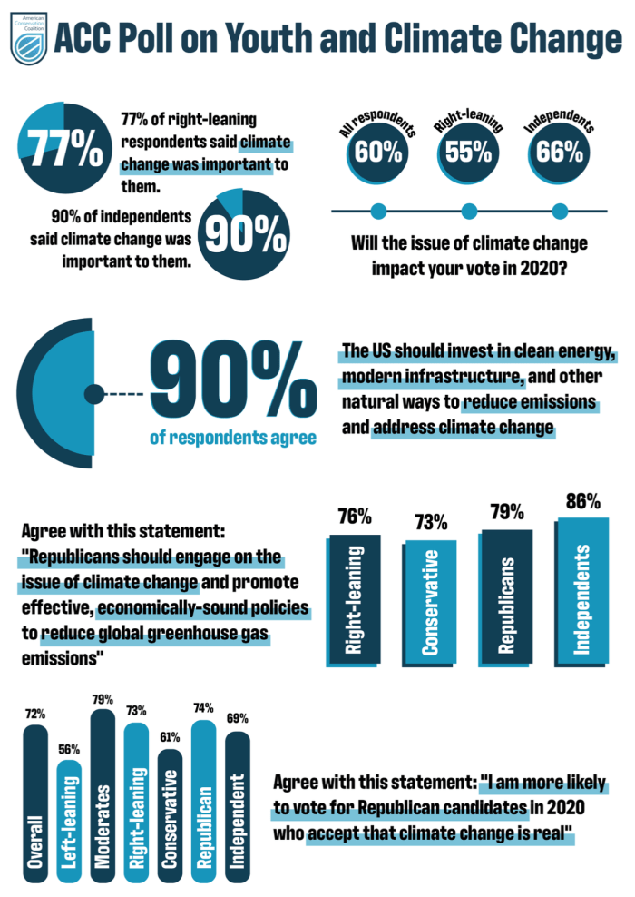
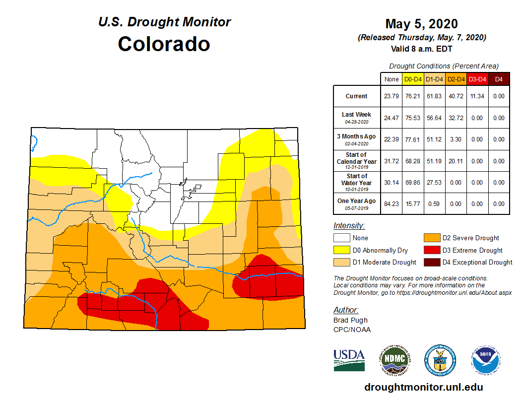
Pew Research Center polling in February found that a growing number of Americans say tackling climate change should be a top priority for the president and Congress. But that change in views is mostly among Democrats: roughly 4 out of 5 say dealing with climate change should be a top priority, compared to just 1 out of 5 Republicans, Pew found.

Climate change wasn’t always so divisive.

In 2008, for example, Speaker of the House Nancy Pelosi, a Democrat, and former Speaker Newt Gingrich, a Republican, famously sat on a couch in front of the U.S. Capitol, declaring they both agreed the country needed to take action on climate change. And they did it for Al Gore, the former vice president and global warming evangelist from Tennessee, who became conservatives’ climate-change punching bag

Today, young climate activists, led by Greta Thunberg and the Sunrise Movement—a grassroots youth climate action group that formed after Trump’s 2016 election—are the defiant voice for the climate, calling for a transformation of the global economy. They are carrying out global student strikes and persuading mayors to declare climate emergencies.

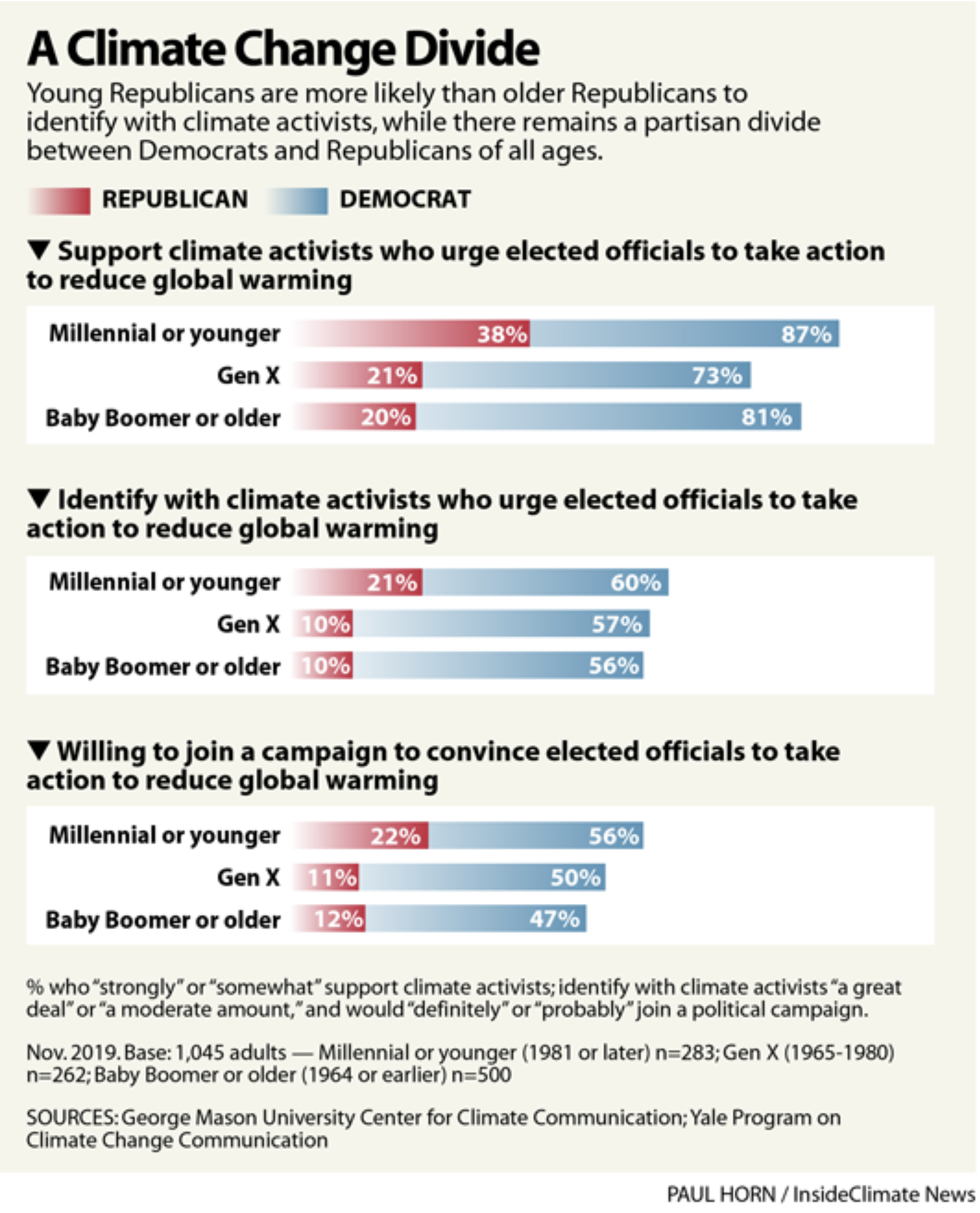
The demographics of climate politics are shifting, said Ed Maibach, professor and director of the George Mason University’s Center for Climate Change Communications.

While young Democrats and their parents and grandparents are “more or less all apoplectically concerned” about the climate, he said, a new report from the George Mason center and the Yale Program on Climate Communication identifies how young Republicans are becoming emboldened by the issue. In contrast to older Republicans, they have become more accepting of the human causes of climate change, rejecting the climate science denial that has taken hold in the party, Maibach said.

“The more young Democrats get involved in the issue, the more young Republicans get pulled along,” he added.

Both parties will have plenty to debate this year as voters in November decide whether to give Trump and his fossil fuel agenda another four years. Presumptive Democratic nominee Joe Biden, the former vice president, has described the Green New Deal as “a crucial framework” for climate action as he tries to convince climate voters he’s a true believer.

A Market Approach to Climate Change Mitigation

The American Conservation Coalition was founded in 2017 by Benji Backer, a 22-year-old from Appleton, Wisconsin, who was already a veteran in national political circles.

In 2014, at 16, Backer delivered a fiery speech at the influential American Conservative Union conference, defending former Wisconsin Republican Gov. Scott Walker’s bitter and successful battle against unionized teachers and declaring it “OK to stand up to those on the left that would scream us into quiet submission.”

But in September, he testified before Congress with Thunberg, arguing that “we cannot regulate our way out of climate change.”

The group and its climate contract have supporters ranging from natural gas lobbyists and libertarians to conservation and energy efficiency groups.

One of them is the Rocky Mountain Institute, a Colorado-based clean-energy think tank founded by physicist Amory Lovins. The institute’s Paul Bodner, who worked on energy and climate in the White House for President Obama, is on the coalition’s advisory board. He hopes he can help the young conservatives find their voice on climate issues.

The institute, he said, agrees with the Green New Deal’s “call to action” and shares its vision of “radical decarbonization of the U.S. economy,” but also agrees with the coalition’s “focus on unleashing market forces.”

The Bipartisan Policy Center, a Washington based think tank, also supports the young conservatives.

“When we see historically controversial policies that are pushed through by one party in a very politicized or polarized manner, those policies are more at risk of being undone, or vilified, at some point in the future,” said Sasha Mackler, the center’s director of energy projects. “For policies to be enduring over the long term, which is really what we need for a climate solution to be effective, bipartisanship is essential.”

‘We Would Rather Not Get Caught up in Debates’

The young conservatives’ contract makes no mention of the 2016 Paris climate agreement, with its goal of limiting rising global temperatures to well below 2 degrees Celsius. Nor does it share the sense of urgency expressed by scientists, who, in 2018, concluded that the world had about 12 years to get on a path toward zero carbon emissions by 2050.

Instead, the contract merely acknowledges the need to “move towards the goal of global net-zero carbon emissions by 2050.”

The Green New Deal envisions a rapid transition to a carbon-free economy, promising jobs and economic security and explicitly supporting an economic transition in communities that have long lived on incomes from fossil fuel industries.

By contrast, the contract modestly calls for “targeted investment and regulatory streamlining;” increasing clean transportation; creating a more energy-saving electrical grid; maximizing carbon storage in forests and farms; planting trees; supporting nuclear power; and establishing private-public partnerships.

“We would rather not get caught up in debates on targets that are too much for one side of the aisle or the other,” said Danielle Butcher, chief operating officer of the American Conservation Coalition. “We view this not as a silver bullet to climate policy.”

The contract also does not recommend a carbon tax, which some moderates and Republicans have begun to embrace as a way to put a price on carbon and steer the economy toward a lower-carbon future.

“We want to focus on the steps we can take right now,” Butcher said.

The contract’s modest scope is its failing, critics counter.

Fighting climate change and economic injustice go hand-in-hand, said Sophie Karasek, a spokeswoman for the Sunrise Movement, which has rallied around the Green New Deal.

“A lot of young people have grown up with the fear of the climate crisis, and we already lived through the great recession, and remember what that felt like,” Karasek said.

What’s needed are “bold solutions from the government at the scale of the problems we face, and right now (with the Covid-19 pandemic) we are facing a great depression while also staring down the barrel of climate change,” she said. “We don’t have time to talk about private-public partnerships, or whatever.”

Mitch McConnell Has Been Setting the GOP Agenda on Climate

In Tennessee, Sage Kafsky, a 23-year-old volunteer with the American Conservation Coalition, echoed her young colleagues’ calls for market based, limited government solutions. But she also declared an admiration for Thunberg, the Swedish teenager whose defiance before the most powerful business and political leaders on the planet became the face of a new generation fighting climate change.

“I 100 percent believe in climate change,” Kafsky said in a telephone interview from her home in Ducktown, Tennessee, in the southern Appalachian Mountains, where she works as a paraprofessional in an elementary school. “I believe in people like Greta, who are having their voice, saying this is a major issue, and we need to fix it.”

But, she went on to say, “how to get there gets lost in translation” amid political polarization, even though “we have similar goals in mind.”

In Washington, D.C., it has been McConnell, 78, the coal-friendly Senate Republican Leader since 2006 and Majority Leader since 2015, who has, in effect, been setting the Republican legislative agenda on climate.

For example, he led the opposition to Obama’s climate and coal policies, then backed Trump on pulling out of the Paris agreement. Last year McConnell went out of his way to force Democrats to make a premature and what he hoped would be a politically damaging vote on the Green New Deal, while not offering alternative climate legislation.

McConnell is up for reelection to a seventh term in November. A spokesman declined to comment on the young conservatives’ efforts, except to say that the way to address climate change “is through technology and innovation.”

But words alone may not be enough for the GOP’s new generation.

Butcher, of the conservation coalition, said the group has met with White House and McConnell staff to find policies that will reduce emissions and create economic prosperity. “Given the overwhelming consensus among young Republicans that climate is a top priority, we expect they’ll increasingly engage on the issue, and if not, we’ll push harder,” she said.

Myles, the libertarian-climate activist from the University of Louisville, came to see climate change as an issue the GOP couldn’t ignore or deny. “Getting into college and seeing how many other people care about it made me realize this is going to be a major issue and something that has the ability to affect all of us,” he said. “The GOP is moving on some issues, as more and more young people get involved. Climate change should be one of them.”

Virtual Mesa State of the River, May 20, 2020 #ColoradoRiver #COriver #aridification

Click here for all the inside skinny.

The #coronavirus outbreak is disrupting the supply chain for some raw materials #COVID19

Photo credit: New York Amsterdam News

From The Deseret News (Amy Joi O’Donoghue):

The report by the International Energy Agency points out that South Africa’s lockdown initially disrupted 75% of the global output of platinum, which is used in many clean energy technologies and emissions control devices.

Copper mining in Peru — which accounts for 12% of global production — ground to a halt, according to the report. Indonesia, which is the world’s top supplier of nickel, banned nickel ore exports earlier this year.

The report also points out that when it comes to lithium, cobalt and various rare earth materials, the top three producers control well over three quarters of the global output.

There are also stark vulnerabilities in the geographic concentration of refining operations, with China alone accounting for 50% to 70% of global lithium and cobalt refining. China is also responsible for 85% to 90% of processing rare earth materials into metals and magnets.

“The COVID-19 pandemic is again reinforcing the importance of responsible U.S. mineral development. During trade negotiations in June 2019, China threatened to cut off our access to rare earth minerals. Now, the COVID-19 shines a bright light on China’s dominance of critical mineral and other supply chains,” said the caucus’ executive vice chairman, Rep. Scott Tipton, R-Colo. ”This report should serve as a reality check that supporting a true all-of-the-above energy future in the U.S. will require strong investments in domestic mining,”

The rising installation of clean energy technologies is set to “supercharge” the demand for critical minerals, the agency predicts, and the already rapid growth was putting strains on supply even before the global pandemic.

Clean energy technologies, the report said, generally require more minerals than their fossil fuel counterparts.

As an example, an electric car uses five times as many minerals as a conventional car and an offshore wind plant requires eight times as many minerals as a gas-fired plant of the same capacity…

The most efficient coal-fired power plants, too, require a lot more nickel than the less efficient ones to produce higher combustion temperatures.

Since 2015, the report points out, electric transport and grid storage have become the largest consumers of lithium, accounting for 35% of the demand. And likewise, those users have driven demand for cobalt from 5% to nearly 25% in that same period.

Those demands, however, come with costs.

Congo, which controls the majority of the world’s supply of cobalt, nearly tripled its royalty rate in 2018 and has come under harsh scrutiny for its extraction practices in harsh conditions amid reports it also relies on child labor.

In its report, the agency recommends government and companies take a number of steps to ensure a steady supply chain and greater independence in the arena of critical minerals, including timely investments in new mines, periodic assessments, promotion of recycling of end of life materials to capture valuable minerals, and stepping up research and development in substitution materials…

Utah is the only state in the country that produces magnesium metal and is one of two U.S. states that produces potash.

While lithium is not being mined in Utah at this point, there is potential for U.S. Magnesium to produce it as a byproduct.

In a paper she wrote for the survey on battery metals’ demand, Mills details the potential of some of these elements to be “mined” in Utah as a byproduct of other metals, such as copper or uranium deposits revealing cobalt.

Utah hosts the only operating uranium and vanadium mill in the United States, Mills points out, and while there is not any uranium mining going on, the mill began producing vanadium from stockpiles in 2019. Vanadium can be used in high-capacity batteries used for large-scale energy storage applications.

Finally, Rio Tinto’s Kennecott operations in Utah puts it as the nation’s second largest producer of copper, which is unmatched in its ability to conduct electric currents.

In addition to copper, Kennecott is one of the largest producers of gold, silver, platinum group metals and molybdenum in North America, and could be a potential source of critical minerals such as rhenium and tellurium.

Rio Tinto is a member of the U.S. Department of Energy’s Critical Materials Institute and is jointly investigating with its experts on ways to extract additional critical minerals from the existing refining and smelting process.

Rhenium, one of the rarest elements, has the third-highest melting point and its nickel-based alloys are used in exhaust nozzles of jet engines. Its alloys are also used in oven heating elements and X-ray machines.

Mills said the state is engaged in research related to the production of tungsten — another critical mineral — which is the only other metal element with a higher melting point than rhenium.

#Megadrought ‘Unprecedented in Human History’ Likely the New Normal Across the West — CBS San Francisco #ColoradoRiver #COriver #aridification

Brad Udall: “…latest version of my 4-Panel plot thru Water Year (Oct-Sep) of 2019 of the #coriver big reservoirs, natural flows, precipitation, and temperature. Data goes back or 1906 (or 1935 for reservoirs.) This updates previous work with
@GreatLakesPeck

From CBS San Francisco (John Blackstone):

“The persistence of the drought conditions, in the Colorado River basin especially, is essentially unprecedented in human history,” John Fleck, author of “Water is for Fighting Over,” told CBS News’ John Blackstone.

Fleck has spent years studying the Colorado River, a crucial source of water for much of the region around it. He said that Lake Mead and Lake Powell’s reservoirs have what he described as “big bathtub rings” around them, left behind as the water declines.

“There is less water in the system now than there was 20 and 30 years ago,” he said.

Fleck explained that a “wet year” every few years may seem like the drought is ending but those years are still comparatively lower than decades before.

“When we do get a snowpack in the mountains over winter, we are seeing less water make it into the rivers and downstream to the farms and cities and the fish and the ecosystems that depend on the water,” he said…

“If they go back in time 500 years or so, there were these phenomenal droughts — in terms of both severity and in terms of length,” Park Williams, the scientist leading the research, said. “And until recently, those droughts have always been spoken about with almost a mythical-type character.”

Williams said the drought of the last two decades “developed the same way that the megadroughts did.”

However, the key difference now is climate change’s effect on weather conditions in the area, which largely depends on melting snowpacks to fill reservoirs.

“Without human-caused climate change, we would still have a drought,” Williams said. “But it wouldn’t be a serious as the one we’ve actually seen.”

West Drought Monitor May 5, 2020.

Simple strategies can cut water use and save money — News on TAP

From faulty flappers to sunken sprinklers, how small things can add to your water bill. The post Simple strategies can cut water use and save money appeared first on News on TAP.

via Simple strategies can cut water use and save money — News on TAP

#Drought/#runoff news: Parts of SW #Colorado slip back into Extreme Drought, #AnimasRiver runoff expected to peak early

From The Durango Herald (Jonathan Romeo):

Extreme drought has crept back into Southwest Colorado…

“With climate change, we expect to see these really big swings from wet to dry years,” said Brad Udall, a senior water and climate research scientist with Colorado State University. “But the trend is we’re in a mega-drought.”

For context, Udall said it’s important to look at Colorado’s weather the past three years. In 2018, it was one of the hottest and driest years on record. The next year, however, brought one of the best snowpacks in recorded history.

For 2020, it appears the pendulum has swung back to hot and dry.

“It’s not as bad as 2018, but it’s still bad,” Udall said. “Probably within the bottom 10 driest years on record.”

West Drought Monitor May 5, 2020.

On Thursday, the U.S. Drought Monitor relisted parts of Southwest Colorado in the “extreme drought” category for the first time since the region was downgraded after the 2018-19 winter…

Southwest Colorado’s current dry spell began in October 2019 and lasted through the winter. Though high elevation weather stations recorded about normal snowpack levels, researchers estimated snow levels were below average.

This spring, too, has been all but void of precipitation. April saw just 10% of normal precipitation levels for the region, making it one of the driest months on record. From October to April, the region saw 70% of its average precipitation levels.

As a result, the Animas River is expected to have 63% of its normal water supply.

Unusually high temperatures, too, have exacerbated the lack of snow and rain. In April, for instance, the region was 10 to 20 degrees higher than average, according to data from the Colorado River Basin Forecast Center.

Above-average temperatures this early in the season have caused snowpack to melt and rivers to run higher and earlier than normal. The Animas River, for example, is expected to peak this weekend at around 2,700 cubic feet per second. By comparison, the Animas River usually peaks during the first week of June around 4,700 cfs.

Most of the snow has already melted off the San Juan Mountains – the Animas, Dolores, San Miguel and San Juan river basins have just 50% of normal snowpack levels for this time of year.

The hot and dry conditions have elevated concerns about fire danger in the region. Pugh said soil moisture is in the lowest fifth percentile, a sign that fuels on the ground are ripe to burn and would be difficult to put out.

Hal Doughty, chief of Durango Fire Protection District, said local fire chiefs in the region sent a letter Friday to La Plata County, requesting commissioners implement Stage 1 fire restrictions.

La Plata County commissioners are expected to vote on the restrictions Tuesday. The Southern Ute Indian Tribe implemented Stage 1 fire restrictions on Friday…

On April 7, the Forest Service announced a complete fire ban across 24 national forests in the Rocky Mountain region, including the San Juan National Forest.

Lorena Williams, spokeswoman for the Forest Service, said the agency is expecting above-average fire potential in May and June.

“Fuel dryness levels have hit critical levels, and above-normal fire potential exists at all snow-free elevations in Southwest Colorado,” she said. “We are preparing for active fire behavior that will be difficult to control. As we’ve seen very recently, any ignitions can lead to rapid fire spread when aided by wind and slope. As fuels dry even more, less wind and less slope will result in the same amount of spread.”

Udall said there is some connection between dry years and wetter monsoons later in the summer: The sun heats the land more, which pulls moisture-laden air from thousands of miles away.

“I don’t think there’s any question that happens,” he said. “But it’s just not a guaranteed thing. The odds are just higher.”

Udall pointed to a scientific study published April 17 in Science that concludes a drought of epic portions is the new reality for the American Southwest, driven in part by climate change…

Williams and his colleagues, however, found by studying soil moisture content in tree ring records that the region had experienced four periods of more than two decades of severe drought conditions in the past 1,200 years.

The study found the current drought in the region since 2000 is the second-worst drought experienced in that time span, second only to a dry spell in the 1500s.

Add complications with climate change, which is expected to move storms farther north and raise temperatures in the Southwest, and concerns about water availability and intensified wildfire seasons begin to mount.

“I’ve always been worried about Southwest Colorado,” Udall said. “As the planet warms, areas right on the edge of big deserts like Southwest Colorado are really at risk.”

San Miguel, Dolores, Animas, and San Juan Basin High/Low graph May 7, 2020 via the NRCS.

#Runoff news: Rivers rising along with the spring temperatures — early peak, or maybe multiple peaks possible — The Sky-Hi Daily News

From the Glenwood Springs Post Independent via The Sky-Hi News (John Stroud):

Rivers are rising faster than usual throughout the Colorado and Roaring Fork river watersheds, as warm temperatures have led to early melting of the high-country snowpack.

Higher river flows have also drawn paddlers to the Glenwood Springs Whitewater Park, as the facility officially reopened this week with public health guidelines in place amid the ongoing coronavirus pandemic…

Commercial rafting is on hold until later this month or early June while guidelines are being developed for that and other tourist activities. Private boats are allowed on the rivers, but with social-distancing and other health guidelines in mind.

The higher river flows are the result of warmer-than-normal temperatures across Colorado’s Western Slope, and the lack of precipitation to add to the mountain snowpack in April, according to Ken Leib, hydrologist with the United State Geological Survey in Grand Junction…

Leib said the Colorado River could see peak flows earlier than usual if the warmer weather continues, or possibly an early peak and then a second peak in June if temperatures modify.

After the record snowpack during the winter of 2018-19, the peak flow on the Colorado River below the confluence with the Roaring Fork River in Glenwood Springs didn’t come until July 1, 2019, according to USGS historical data.

The flow last year topped out at 20,800 cubic feet per second (cfs), at a depth of 9 feet, 8 inches at the Glenwood measuring station.

Dating back to 1967, the highest peak flow at Glenwood was 31,500 cfs on May 25, 1984. The earliest peak flow came on May 20, 1996, at 18,200 cfs.

As of Thursday evening, according to realtime USGS data, the Colorado at Glenwood was flowing at 5,150 cfs with a depth of 5 feet, 8 inches — down from the Monday high this week of 6,000 cfs and 6 feet, 1 inch.

Just above the confluence on the Roaring Fork River at Veltus Park, the flow in the Fork was topping out at 1,200 cfs with a gage depth of 3 feet, 3 inches. The peak flow on the Roaring Fork at that location last year also came on July 1, at 8,960 cfs.

USGS data goes back to 1906 for that location on the Roaring Fork. The earliest recorded peak came on May 12, 1934, when the flow topped out at 4,100 cfs.

Craig: Chloramine conversion process scheduled to begin May 11, 2020 — The Craig Daily Press

Craig. Jeffrey Beall / CC BY (https://creativecommons.org/licenses/by/3.0)

From The Craig Daily Press (Joshua Carney):

Following a number of delays, the monochloramine conversion process within the city’s water department is scheduled to officially start on Monday, May 11 at 10 a.m.

According to a press release from the City of Craig Water & Wastewater Department Director Mark Sollenberger, the city’s water department has resolved a number of issues and is ready to get the project, previously scheduled to start on March 31, underway.

“After numerous weeks of working on the primary disinfection portion of the treatment plant upgrade, our engineers, staff, and contractors have finally resolved many of the issues preventing the original March 3 start date for the chloramine conversion process,” Sollenberger said in the press release. “Be assured that we are now ready to proceed and that the entire conversion process of the water plant, and roughly 80 miles of water distribution system, will still take approximately 3 weeks to be fully completed.”

Sollenberger added that the city will continue to flush fire hydrants in the distribution system throughout the entire conversion process to help move chloraminated water around the entire water system and support normal system maintenance.

“The public should please note that fire hydrant flushing can cause discolored water or pressure fluctuations at your home. If you encounter these problems, they should clear up quickly if you run your water faucets throughout the house for a short period of time. We apologize for this inconvenience,” Sollenberger said.

The controversial monochloramine project to add monochloramines to the current use of chlorine for water disinfection has the city’s water department monitoring water quality now, and moving forward, Sollenberger added.

“Please be assured that throughout the chloramine conversion process, and long afterwards, the City Water Department staff will be monitoring the water quality in the water distribution system to make sure it always remains safe and is of the highest quality we can deliver to our customers,” Sollenberger said.

Water future: Community input sought — The Pagosa Sun #COWaterPlan

Here’s a guest column from Al Pfister that’s running in The Pagosa Sun:

We are living in an age where we are facing drier and warmer times ahead. While we have had a few wet years over the past two decades, looking over that entire time span, we have been in a drought. We are currently in a severe drought with gradually worsening conditions in southern Colorado over the past few months. This scenario is believed to be a foreshadowing of our future.

The Colorado Water Plan, completed in December 2015, recognized these conditions and outlined numerous strategies to guide all water users in collaboratively addressing our challenging water future.

One of those strategies was the development of stream management plans (SMPs). SMPs are intended to compile a community’s understanding of a watershed’s collective environmental, recreational, agricultural and municipal water needs, identifying information gaps, and promoting projects and processes that meet those needs and gaps.

In 2018, community representatives formed a group, now called the Upper San Juan Watershed Enhancement Partnership (WEP), to better understand current and future local water use and needs through the Colorado Water Plan’s SMP process. Funding for this local effort is provided by the state through Colorado Water Conservation Board (CWCB), Southwest Basin Roundtable, San Juan Water Conservancy District, Archuleta County, Town of Pagosa Springs, Banded Peak Ranch and numerous other partners.

Envisioned as a three-phase process, the ultimate purpose of this effort to explore opportunities to conserve the Upper San Juan Basin streams and their uses with wide-ranging community support and decisions based on local input and current science and assessments. In order to ensure a broad representation of the community’s interests are brought forward and maintained through the process, a steering committee was formed. Representatives of agricultural, environmental, recreational, and municipal water users, private landowners, business owners, and local government comprise the steering committee.

While forming the steering committee and informing stakeholders about this endeavor, the local water users decided to call it the Upper San Juan Watershed Enhancement Partnership to recognize the voluntary and collaborative nature of this effort. Phase I, just completed, of this effort entailed formation of the steering committee and outreach to stakeholders, identification of our community’s collective values on issues, opportunities and the geographic scope of the WEP. Funding for Phase II has been obtained and is now awaiting formal approval from the CWCB in order to proceed with implementation.

Phase II will focus on assessing the environmental, recreational, and agricultural structural water needs and values of our community. We will be working with partners, San Juan Conservation District and Lotic Hydrological, to evaluate current and future water needs via community input and scientific analysis. Our goal is to complete an assessment that can prioritize projects and processes to meet those needs. This assessment will inform the development of an Integrated Water Management Plan that lists goals, potential projects and actions in Phase III, as determined by the local community.

In order to accurately assess and identify projects that align with local values and needs, the WEP is again asking for community input throughout Phase II. To help the WEP and our partners better understand environmental, recreational and agricultural structure needs this year, our partners will be working directly with ditch companies, land owners, governmental agencies, as well as providing updates to the general public throughout the process. We greatly appreciate your involvement and input, helping our communities in the San Juan River Basin better prepare and secure our water future.

More detailed information on the WEP can be obtained at our website: http://www.mountainstudies.org/sanjuan/smp, or by contacting Al Pfister at (970) 985-5764.

San Juan River Basin. Graphic credit Wikipedia.

#Colorado AG, top water quality regulator vow to challenge new Clean Water Act rule — @WaterEdCO #WOTUS #DirtyWaterRule

Ephemeral streams are streams that do not always flow. They are above the groundwater reservoir and appear after precipitation in the area. Via Socratic.org

From Water Education Colorado (Jerd Smith):

Colorado and other Western states will be hard pressed to shield their rivers and streams under a new federal Clean Water Act rule finalized last month, largely because hundreds of shallow Western rivers are no longer protected, and writing new state laws and finding the cash to fill the regulatory gap will likely take years to accomplish, officials said.

Though many agricultural interests and water utilities support the new Waters of the U.S. (WOTUS) rule, as it is known, Colorado Attorney General Phil Weiser and Patrick Pfaltzgraff, director of the state’s Water Quality Control Division, said they will take legal action to protect streams that are no longer subject to federal oversight.

“We are pleased the final rule protects important agriculture exemptions and provides continued assurance that states retain authority and primary responsibility over land and water resources…However, the federal government’s decision to remove from federal oversight ephemeral waters, certain intermittent streams, and many wetlands is based on flawed legal reasoning and lacks a scientific basis,” Weiser said in a statement.

Legal strategy?

Whether Colorado will seek an injunction to stop the new rule from being enforced and whether it will join other Western states in a legal challenge isn’t clear. Weiser and Pfaltzgraff declined to discuss their legal strategy, other than vowing to take action.

The Colorado Water Congress, which represents hundreds of water agencies and agricultural interests, had been largely supportive of the new rule before it was finalized. But Executive Director Doug Kemper said the group hasn’t finished its analysis of the final version.

Formally adopted by the U.S. Environmental Protection Agency April 21, the move to significantly revise the WOTUS rule began after President Trump took office and vowed to reverse policies established under the Obama Administration.

The new rule has already triggered a handful of lawsuits seeking to stop the EPA from enforcing them. One was filed by cattle growers in New Mexico alleging that the rule is still too onerous, and at least two others have been filed by environmental interests in South Carolina and Massachusetts, who say the rule leaves too many streams unprotected.

And more are expected.

The Clean Water Act (CWA) has been legally hamstrung for years over murky definitions about which waterways fall under its jurisdiction, which wetlands must be regulated, what kinds of dredge-and-fill work in waterways should be permitted, what authority the CWA has over activities on farms and Western irrigation ditches, and what is allowable for industries and wastewater treatment plants to discharge into streams.

One rule never fits all

Administered by the U.S. Army Corps of Engineers and the EPA, the CWA, now nearly 50 years old, is credited with making U.S. waters some of the cleanest in the world. But it has also been, at times, fiendishly difficult to administer, in part because of the nation’s widely different geographies.

Go to the East or Midwest, and massive rivers, such as the Ohio and Missouri, are filled with barge and shipping traffic and are clearly “navigable.” That was the term early courts used to determine how water would be regulated. If a stream was considered navigable, it was subject to federal law.

But Colorado and other Western states rely on shallow streams that don’t carry traditional commercial traffic. The U.S. Geological Survey estimates 44 percent of Colorado’s streams are intermittent, meaning they are sometimes dry, and 24 percent are ephemeral, meaning they can be dry for months or years and appear only after extraordinary rain or snow. Just 32 percent of Colorado streams are classified as being perennial, meaning they flow year round.

Under the new rule, only perennial and intermittent streams, or those deemed navigable, will be regulated, meaning that thousands of miles of streams in Colorado and other Western states would no longer be protected under the law.

A financial quandary

And that worries state water quality officials who are responsible for protecting Colorado’s streams.

They warn that writing state rules and finding millions of dollars in new cash to enforce water quality protections will be difficult, especially as the COVID-19 budget crisis unfolds. Officials of the Colorado Department of Public Health and Environment (CDPHE), which includes the Water Quality Control Division, say that until state rules are in place, new housing developments and other projects could be stopped because there is no mechanism yet to issue the permits that were once issued by the federal government.

“While the specific impacts of this rule still are being determined, there’s no question this rollback removes huge swaths of Colorado’s waters from federal jurisdiction—the most of any administration since the passage of the Clean Water Act in 1972. The state will need to put in significant resources to determine how to continue to protect these waters and to determine how this rule will be implemented as the rule is unclear as written,” the CDPHE said in an email.

“Specific construction projects and associated permitting processes that were originally covered…won’t be able to move forward without doing so illegally and harming the environment,” the CDPHE said.

Potential dysfunction

Melinda Kassen, general counsel for the Theodore Roosevelt Conservation Partnership, said it would make sense to pursue an injunction to give the state time to set up its own regulations and find a way to fund them.

“If you read the economic analysis that accompanies the rule, there are assumptions that the states will step up and take this over. The potential is for it to be really dysfunctional. We’ve got to get something set up,” Kassen said.

EPA officials have said they don’t expect federal funding to enforce the Clean Water Act will be reduced, even though the new WOTUS rule is smaller in scope and governs fewer waterways.

Still the CDPHE and most opponents of the new rule believe millions of dollars will be needed to fill in any regulatory gap.

How far Colorado will go to challenge the new rule isn’t clear. The CDPHE’s Pfaltzgraff said his agency is still analyzing its next steps.

“It is now up to the state to provide the necessary protection of both Colorado’s economy and the environment,” Pfaltzgraff said in a statement. “We are going to do everything we can, while also addressing the impacts from COVID-19, to ensure Coloradans live in the healthy state they deserve.”

Jerd Smith is editor of Fresh Water News. She can be reached at 720-398-6474, via email at jerd@wateredco.org or @jerd_smith.

R.I.P Little Richard “When you’re rockin’ and a rollin’ can’t hear your momma call”

Trading card photo of Little Richard In 1957, Topps gum cards issued a series of movie stars, television stars and recording stars. He was part of their recording stars cards. TGC-Topps Gum Cards / Public domain

From The New York Times (Tim Weiner):

Richard Penniman, better known as Little Richard, who combined the sacred shouts of the black church and the profane sounds of the blues to create some of the world’s first and most influential rock ’n’ roll records, died on Saturday morning in Tullahoma, Tenn. He was 87…

Little Richard did not invent rock ’n’ roll. Other musicians had already been mining a similar vein by the time he recorded his first hit, “Tutti Frutti” — a raucous song about sex, its lyrics cleaned up but its meaning hard to miss — in a New Orleans recording studio in September 1955. Chuck Berry and Fats Domino had reached the pop Top 10, Bo Diddley had topped the rhythm-and-blues charts, and Elvis Presley had been making records for a year.

But Little Richard, delving deeply into the wellsprings of gospel music and the blues, pounding the piano furiously and screaming as if for his very life, raised the energy level several notches and created something not quite like any music that had been heard before — something new, thrilling and more than a little dangerous. As the rock historian Richie Unterberger put it, “He was crucial in upping the voltage from high-powered R&B into the similar, yet different, guise of rock ’n’ roll.”

Art Rupe of Specialty Records, the label for which he recorded his biggest hits, called Little Richard “dynamic, completely uninhibited, unpredictable, wild.”

“Tutti Frutti” rocketed up the charts and was quickly followed by “Long Tall Sally” and other records now acknowledged as classics. His live performances were electrifying.

“He’d just burst onto the stage from anywhere, and you wouldn’t be able to hear anything but the roar of the audience,” the record producer and arranger H.B. Barnum, who played saxophone with Little Richard early in his career, recalled in “The Life and Times of Little Richard” (1984), an authorized biography by Charles White. “He’d be on the stage, he’d be off the stage, he’d be jumping and yelling, screaming, whipping the audience on.”

An Immeasurable Influence

Rock ’n’ roll was an unabashedly macho music in its early days, but Little Richard, who had performed in drag as a teenager, presented a very different picture onstage: gaudily dressed, his hair piled six inches high, his face aglow with cinematic makeup. He was fond of saying in later years that if Elvis was the king of rock ’n’ roll, he was the queen. Offstage, he characterized himself variously as gay, bisexual and “omnisexual.”

His influence as a performer was immeasurable. It could be seen and heard in the flamboyant showmanship of James Brown, who idolized him (and used some of his musicians when Little Richard began a long hiatus from performing in 1957), and of Prince, whose ambisexual image owed a major debt to his.

Presley recorded his songs. The Beatles adopted his trademark sound, an octave-leaping exultation: “Woooo!” (Paul McCartney said that the first song he ever sang in public was “Long Tall Sally,” which he later recorded with the Beatles.) Bob Dylan wrote in his high school yearbook that his ambition was “to join Little Richard.”

Click on the image to read the whole thread.

From The New York Times (Myles E. Johnson):

Little Richard, who died Saturday, showed us what sexuality, queerness and passion looked like onstage. When he first rose to prominence in the 1950s, it was more common for popular performers such as Frank Sinatra or Ray Charles to don a suit and tie. Even in the 1960s, he was an anomaly — James Brown may have matched him onstage in exuding sexual energy, but the Godfather of Soul’s sartorial choices remained primarily urbane until the 1970s.

Little Richard’s style was a reckoning between the sweaty southern Baptist church revivals he witnessed as a child, and the raw sensuality that characterized jazz and blues. He bridged and made sense of the flamboyance and theatricality of the black church, and fed it to millions of hungry consumers. And he did it all while embracing a femininity that can be directly traced to his queerness.

We often think about the history of rock ‘n’ roll through the lens of white artists and record executives profiting from black culture, but it’s rare we recognize that the musicians being stolen from have often not only been black, but queer as well. Artists like Little Richard are often seen as separate from their sexuality and gender performance, even though those are the very things that informed their innovation.

Josephine Baker, Ma Rainey, Sister Rosetta Tharpe, Zora Neale Hurston and James Baldwin to name just a few — it would not be a stretch to say that mainstream culture as we know it is a black queer project, often appropriated by others but birthed by black queer people.

One of the primary ways we remember and memorialize our biggest stars is through onscreen dramatizations of their lives; often, these images play a huge part in the mythmaking of their personas. This format is also a common way to erase more complex facets of those figures. In the 2000 biopic “Little Richard,” there is no mention of his queerness, no attempt to connect his gender performance to his brilliant artistry. Likewise, in the 1991 biopic “The Story of Josephine Baker,” there is no reference to Baker’s reported relationships with women…

The loss of Little Richard, the person, is sad. But he remains living through the work of so many artists who followed in his footsteps: Aretha Franklin, Prince, Marilyn Manson, Björk, Beyoncé, Lady Gaga and on and on.

Now is an opportunity to show reverence to the artist. It’s also the right time to remind ourselves that black queer contributions have changed the way we live, think and in the case of Little Richard, listen.

A Decent Winter Becomes A Lousy Spring On The #RioGrande — #NewMexico in Focus #snowpack #runoff

From New Mexico in Focus (Laura Paskus):

This spring, the Rio Grande through Albuquerque is running at about 20 percent of its historic average—even though snowpack in the watershed was close to average last fall and into February. Conditions won’t get much better: Peak snowmelt occurred last week, according to the U.S. Bureau of Reclamation.

“This year was more along the lines of what I anticipate for the future, to happen more often,” says David Gutzler, professor of Earth and Planetary Sciences at the University of New Mexico. Gutzler has been studying climate change in the southwestern United States for decades.

Increasingly warm conditions play out in predictable ways in the arid Southwest. That includes having less water in rivers, even when the region isn’t necessarily mired in drought, experiencing a deficit in snowpack or rainfall.

“You get snow in the winter when it’s really cold, but then things get warm and dry—which is the long-term outlook for springtime in the Southwest—and the snow just melts away faster than our historical statistics would suggest,” Gutzler says of this year’s conditions.

“This is more like a global warming-style of a low streamflow year, as opposed to a drought year [like 2018] that started off bad and stayed warm, and was just bad for the whole winter.”

Two years ago, then-UNM graduate student Shaleene Chavarria published her research with Gutzler about declining snowmelt and streamflows in the Rio Grande. In that peer-reviewed study, she looked at annual and monthly changes in climate variables and streamflow volume in the headwaters of the Rio Grande in Colorado between 1958 and 2015. She found that flows are declining in March, April, and May.

Chavarria, a hydrologist, saw something else in the records: Snowpack in the Rio Grande watershed is decreasing. And it’s melting earlier.

That’s definitely playing out again this year.

Looking at the data, Chavarria notes that in 2018 and 2020, snowpack melted out about a month earlier than it normally did in the past. “This is something we address in the paper, and I think it’s interesting and scary to see it happening,” she wrote in an email to NMPBS…

The changes in the timing of spring runoff and in the amount of water flowing within the banks of the Rio Grande affect farmers and cities. They also affect the river’s ecosystem—including the cottonwood bosque—and the species that depend upon its waters and cycles.

Already, according to Carolyn Donnelly with the U.S. Bureau of Reclamation, the water management agency has released about 4,000 acre feet of water from upstream reservoirs to prevent riverbed drying—and it plans to release supplemental water again within the week.

When the Natural Resources Conservation Service released its final May streamflow this week, the numbers were “pretty grim,” says Reclamation spokesperson Mary Carlson.

“In March, we were looking at a runoff that was near average. But that just didn’t materialize,” Carlson says. “We will continue to coordinate closely with our water operations partners to ensure that every drop of the supply that we do have will be used in the most beneficial way.”

She adds that New Mexico will likely end up under Article VII restrictions by the middle of June.

Under that provision of the Rio Grande Compact of 1938, New Mexico is only allowed to store water in upstream reservoirs when levels in Elephant Butte Reservoir are above a certain threshold. With little water flowing into that reservoir this year, the state won’t be able to store waters upstream—and Elephant Butte’s levels will keep dropping, too.

The bureau anticipates Elephant Butte’s levels will drop close to its 2018 historic lows, when the reservoir was at just three percent of capacity. (The reservoir, which was built to hold two million acre feet of water, is about 25 percent full this week. Water stored there is allocated to farmers in southern New Mexico and Texas)

Reclamation also anticipates that the Middle Rio Grande will dry within the next month, beginning within Bosque del Apache National Wildlife Refuge in San Antonio…

Upper Rio Grande River Basin High/Low graph May 7, 2020 via the NRCS.

For decades, the U.S. Fish and Wildlife Service, along with federal, state, tribal, and local partners, has tried to keep the endangered Rio Grande silvery minnow from going extinct. The two-inch long fish was once one of the river’s most abundant. But by the 1990s, its population had plummeted, earning it the dubious distinction of requiring federal protection under the Endangered Species Act. Some of those efforts include releasing water to keep the river flowing longer, and also working with the Middle Rio Grande Conservancy District to release water “spikes” when the minnows are spawning.

When the Middle Rio Grande does dry, as it has many summers since the 1990s, biologists end up in the riverbed, trying to salvage what live minnows they can find. They scoop the fish from pools and puddles, then transport them to sections of the river where flows are high enough to possibly sustain the tiny fish.

Fish and Wildlife Service biologist Thomas Archdeacon anticipates the river will dry around Memorial Day. When that starts happening, biologists will slog through the muddy—and then sandy—riverbed, seeking out the endangered fish.

Rio Grande Silvery Minnow via Wikipedia

May 1, 2020 #Colorado Water Supply Outlook Report — NRCS

Click here to read the report. Here’s an excerpt:

Variable April Precipitation Widens Differences in Streamflow Forecasts — NRCS #runoff #snowpack

Here’s the release from the NRCS (Brian Domonkos):

The month of April brought below average precipitation across all of Colorado with extremely dry conditions in southern Colorado in particular. All major basins in the southern half of the state received less than 50 percent of average precipitation with the Rio Grande at the bottom of the list with a meager 16 percent of average. Most SNOTEL sites in the San Juan and Sangre de Cristo Mountains recorded the lowest or second lowest April precipitation on record. The basins of northern Colorado all received between 77 and 84 percent of average precipitation. “The precipitation differences across the state have caused notable changes to streamflow forecasts across the state since the beginning of April. Considerable declines in streamflow forecasts were observed across southern Colorado over the last month,” states NRCS Hydrologist Karl Wetlaufer. On average streamflow forecasts dropped 10-15 percent in the Rio Grande and combined San Miguel, Dolores, Animas, and San Juan basins and more in some southern tributaries to the Arkansas.

In addition to the past month the 2020 water supply situation is further complicated by conditions leading into the winter season. The late summer and fall of 2019 was also extremely dry leading to very low soil moisture conditions going into winter which can have an effect on the efficiency of snowmelt runoff. Wetlaufer notes that “Dry soils underlying the snowpack can absorb much of the snowmelt in the spring which has the potential to substantially decrease the amount of water that actually makes it to a stream channel to contribute to runoff”. Because of this effect it is anticipated that streamflows will be less than are commonly observed in other years with a similar snowpack peak and particularly in the southern half of the state. Statewide snowpack peaked on April 4th at 103 percent of normal but snowpack accumulation and melt patterns varied widely across the state after that point.

Reservoir storage has not varied widely this water year and statewide storage remains near normal at 104 percent of average. The largest monthly change was observed in the combined San Miguel, Dolores, Animas, and San Juan basins with a 9 percent drop bringing it down to 95 percent of average storage. Recent warm temperatures have been driving accelerated snowmelt which has been helping increase reservoir storage over the last two weeks but that could also lead to an early streamflow peak making that storage more important later in the summer.

So far water year 2020 has been a roller coaster of conditions through time and across the state and the last month has been no different. Given the unique nature of water supply conditions across the state and future weather uncertainty, it will be worth keeping a close eye on changes over the coming months.

Expected spring #runoff into #ColoradoRiver plunges after dry April — Tucson.com

Graphic credit: Colorado River Basin Forecast Center
>

From Tucson.com (Tony Davis):

May’s monthly runoff prediction for the April-through-July period was 65% of average, or 4.6 million acre-feet. That’s 1 million acre-feet less than the April forecast predicted. Tucson Water customers typically use close to 100,000 acre-feet a year.

While low runoff this year is highly unlikely to trigger the river’s first major shortage as soon as 2021, it raises the possibility of one in 2022. A shortage would fall particularly hard on Central Arizona farmers. Flows of water into Powell that would be low enough to cause a shortage in 2022 are likely to occur about 10% of the time, said the U.S. Bureau of Reclamation’s most recent study of its reservoir operations, published in mid-April.

“This could be the start of a multi-year drought. Last year was a wet year, so one year like this we can handle,” said Eric Kuhn, a retired general manager of a northern Colorado water district and author of a recent book on the river. “One dry year doesn’t usually make a difference if we start in good shape. Two dry years or three dry years is a concern.”

The dry April weather wiped out the benefits of a robust winter snowpack in Upper Colorado River Basin states, federal forecasters said this week. Until now, this year’s forecast had been relatively stable, ranging from 74% to 82% of average runoff since January…

But Brenda Alcorn, a hydrologist for the federal Colorado Basin River Forecast Center, said that if the dry spell continues, the eventual runoff could well end up lower than what’s now predicted.

It could possibly fall as low as or lower than the 2018 runoff of 36% of normal, “if we have extreme dryness through the rest of the spring,” Alcorn said.

Since the mid-2010s, the Colorado’s spring-summer runoff has done “a lot of yo-yoing,” Alcorn said.

The runoff rose sharply in 2017, fell sharply in 2018 and soared to 145% of the average runoff in 2019.

While these fluctuations have staved off the shortages that most water experts now view as inevitable, the river is clearly more vulnerable to shortages than it was in 2000, when both Lakes Mead and Powell were full or nearly full.

Today, Lake Mead is 44% full, and Lake Powell is at 48%…

This latest bad spring-summer river runoff forecast, however, stemmed largely from dry, not hot weather, the Colorado Basin River Forecast Center said.

“April precipitation was generally below to much below average across the Colorado River Basin and Great Basin,” the center said in a report on its latest forecast. “It was exceptionally dry over northern Utah and southwest Colorado.”

A number of sites that measure snowpack in Utah and southwest Colorado showed their lowest April precipitation since officials started recording it up to 35 years ago…

April river flows neared record lows in parts of the Gunnison, Dolores and San Juan river basins in the two states.

April temperatures across the basin were generally near the average. Temperatures fell below average for the first three weeks of the month.

#Runoff news: Much of the #ArkansasRiver above Lake Pueblo is currently runnable

Browns Canyon via BrownsCanyon.org

From The Mountain Mail (Cody Olivas):

Nearly the entire [Arkansas River], from Granite all the way to the Pueblo Whitewater Park, is flowing at or above 700 cubic feet per second, the level of flow that Colorado Parks and Wildlife maintains for boating from July 1 to Aug. 15 with its voluntary flow management program.

The river was flowing at 696 cfs Wednesday from Granite to Buena Vista. From Buena Vista to Rincon it was flowing at 1,080 cfs, then at 911 cfs to Cañon City and 665 CFS at Pueblo’s water park.

“It seems runoff typically begins between May 1 and May 15,” Rob White, Arkansas Headwaters Recreation Area park manager, said. “It started a little early this year.”

He said he thinks the whole river is currently runnable, and signs are pointing to a good season.

“It appears like it’s going to be a pretty good whitewater season in terms of water,” White said. He said it will depend on how hot it gets as well as how much rain falls, but he noted that with the upper basin’s SNOTEL sites currently above 100 percent, water levels could be above average this season.

From Steamboat Today (Derek Maiolo):

On Monday, the flow of the Yampa River had risen to more than 2,000 cubic feet per second, according to data from the U.S. Geological Survey. The flow has decreased slightly since then, due mainly to fluctuations in snow melt and temperature.

Portions of the Yampa River Core Trail have been closed due to high water, according to Craig Robinson, parks open space and trail manager for Steamboat Springs Parks and Recreation. Signs have been posted in those areas directing people to detours. Most of the trail closures are on underpasses, Robinson said…

The Yampa River likely will continue to rise and flow at faster rates in the coming weeks, according to Tom Martindale, streets supervisor for the city of Steamboat Springs. The river usually peaks in late May or early June, he said. This comes after snowpack reaches its peak in the higher elevations and warmer temperatures send the melted snow downstream.

The smaller tributaries that feed into the Yampa River likely have reached or neared their peak levels, Martindale added. He regularly surveys Butcherknife Creek and Soda Creek, checking also for any debris, such as trees, that could dam the waterways and lead to flooding. So far, he has not seen any major issues…

The city currently is offering sand and sandbags for residents who want to fortify their homes against flooding. As of Tuesday, the city had set up two collection sites: one at Missouri Avenue and North Park Road, the other at Short and James streets. A third site at Eighth Street and Crawford Avenue will be established this week, Martindale said.

Uncompahgre River Valley looking south

From The Montrose Press (Katharhynn Heidelberg):

Although snow was nearly average through December, it fell to below average for January and February in the Gunnison Basin, then bounced back close to average in March and hit between 90 to 95 percent of average in April, according to the U.S. Bureau of Reclamation, which manages the Aspinall Unit.

Moderate drought conditions persist throughout the basin.

As of last week, snow conditions in the basin sat just below average, with runoff forecast for the rivers 70 to 80 percent of average. The forecast puts the unit in the “moderately dry” year hydrologic category and if that holds, it will call for a one-day peak flow of 7,017 cubic feet per second in the lower Gunnison, as measured at the Whitewater gauge, according to written information from BuRec.

There are no half-bankfull or peak flow duration targets under this type of hydrologic year.

Flows on the Gunnison through the Black Canyon are projected to peak at nearly 4,000 cubic feet per second. After peak, the flows will likely drop to between 500 and 900 cfs and the baseflow targets at the Whitewater gauge, consistent with moderately dry years, are to be between 890 and 1,050 cfs (summer).

Blue Mesa Reservoir was sitting at 515,000 acre-feet and is forecast to hit a maximum content of 730,000 acre-feet by late June, or about 11 feet below what would be a full reservoir, per BuRec.

The reservoir would then slowly decrease to its winter target level of 580,000 acre feet. Black Canyon flows are projected to drop to 400 cfs by early fall, according to BuRec’s report…

Overall precipitation has been “well below normal” since the start of the water year and moderate drought conditions are predicted in most of the basin. The start of the month could bring below normal precipitation and above-normal temperatures — it is expected to be both warmer and drier…

“The snowpack is disappointing, there’s no doubt about that,” Anderson said. The UVWUA experienced an April “hole” this year, when less snow and colder weather in the high country meant there was not enough water to feed the project and the association had to dip into its storage at Ridgway and Taylor Park reservoirs.

However, the UVWUA had full accounts there going into April.

“Currently, we’re not using any storage and that’s a good thing. We still have plenty to make the irrigation season,” Anderson said.

About Those Asian Giant Hornets… — Bug Squad

An Asian giant hornet from Blaine, Wash., to be published n the journal, Insect Systematics and Diversity. (Photo by Allan Smith-Pardo of the USDA)

From the University of California Agriculture and Natural Resources (Kathy Keatley Garvey):

The sensationalism. fear-mongering and general panic surrounding those Asian giant hornets, aka “murder hornets,” detected last year in British Columbia and Washington state, are enough to curdle both the blood and the brain.

First there were the Africanized honey bees, which sensationalists called “the killer bees.”

Don’t even mention “assassin flies” or “bullet ants” or “deathwatch beetles.”

Now there are the Asian giant hornets (AGH), Vespa mandarinia, which sensationalists have dubbed “murder hornets.”

“It’s ridiculous to call them murder hornets,” says noted UC Davis wasp expert and researcher Lynn Kimsey, director of the Bohart Museum of Entomology and professor of entomology, UC Davis Department of Entomology and Nematology.

“It’s no more likely to sting and kill a human than a honey bee,” said Kimsey, a two-term past president of the International Society of Hymenopterists, an organization that studies bees, wasps, ants, and sawflies.

“Actually it’s less likely, as honey bee venom packs quite a punch and it is exclusively designed to defend against vertebrates,” she said.

“The colony everyone is hyperventilating over was actually found on Vancouver Island, British Columbia, last September when it was destroyed and then a single, dead hornet was found in December in Blaine, Wash.,” Kimsey said. “There is no evidence that there are any more hornets in the vicinity of Vancouver or anywhere else on the West Coast.”

A screen shot of the Washington State University Extension Fact Sheet on the Asian giant hornet via UCANR.

A colony of the Asian giant hornets was found and destroyed Sept. 18, 2019 in Nanaimo, Vancouver Island, and the single dead hornet was found Dec. 8, 2019 in Blaine.
These were the first detections of this species in North America, but there may be more, according to the Washington State Department of Agriculture (WSDA). Beekeepers have reported “observations” (which may or may not be the same species) dating back to October 2019, according to officials in Washington State University’s Department of Entomology and Cooperative Extension. They and the beekeeping organizations want to know what’s out there and they want folks to keep a lookout for them.

Said Kimsey: “A decade or more ago there was a colony of another species, Vespa asiatica, reported near the Port of Long Beach but nothing ever came of that either. A European species, Vespa crabro, was introduced into the East Coast perhaps a century ago and it is now fully established in the southeastern U.S.”

Kimsey points out that insects often come in cargo boxes from Asia to U.S. ports, establish colonies, and expand their range.

A soon-to-be-published article in the Entomological Society of America’s journal, Insect Systematics and Diversity, promises to shed more light on the genus and the history of introductions in the United States.Kimsey and colleagues Allanmith-Pardo of the USDA and James Carpenter of the America Museum of History, New York, co-authored the review article.

In the abstract, the authors define Vespa as social wasps that are “primarily predators of other insects, and some species are know to attack and feed on honey bees, Apis mellifera, which makes them a serious threat to apiculture.”

“Vespa nests can be physically large, with over 1,000 workers, but usually with hundreds of workers,” they wrote. “Nests can be aerial, attached to tree branches or in shrubs, in crevices, under eaves or underground depending on the species. Depending on the latitude, nests can be either annual, started by a new queen every spring, or perennial, where young queens take over from old ones. Colonies in warm tropical climates tend to be perennial.”

Washington State University (WSU) Extension recently published an AGH fact sheet, the work of three scientists: Susan Cobey, bee breeder-geneticist and husband Timothy Lawrence, county director of Island County Extension (both formerly of UC Davis), and Mike Jensen, county director of Pend Oreille. (See https://bit.ly/2SA3TxS)

Yes, hornets are huge. They measure about two inches long, and the queens can fly up to 20 miles per day, said Cobey, who examined specimens in Japan last December and shipped some of them to WSU.

The WSU scientists wrote that AGH “is the world’s largest species of hornet, native to temperate and tropical Eastern Asia low mountains and forests. The hornet is well adapted to conditions in the Pacific Northwest.”

“The primary purpose of venom is defense against predators by inflicting pain and damage,” they wrote. ”Vespa mandarinia is one of the two most venomous known insects in the world.. The amount of venom each wasp delivers (4.1 μl/ wasp) has designated V. mandarinia as the most venomous insect. In comparison, the honey bee has about 0.6μl/bee. When foraging for food in spring, the AGH is not highly defensive – unless its nest is disturbed. Late summer and fall, with the high demand for protein, they become very aggressive when attacking or occupying a honey bee colony.”

“It is critical that we identify, trap, and attempt to eliminate this new pest before it becomes established and widespread,” they wrote. “Attempts to contain the spread and eradication of this invasive insect will be most effective in trapping queens during early spring before their nests become established. Finding the nests can be a bit of a challenge. Their nests are typically in the ground though they can also be found under overhangs and within wall voids. The AGH is a strong flier and often will fly up and away and have an extensive flight range. Thus tracking can be difficult.”

They advise residents to “proceed with extreme caution and contact WSDA immediately. Do not try to exterminate the nest yourself.”

Entomologists call them Asian giant hornets or Vespa mandarinia.

Social media?

Murder hornets.

Could we just go back to calling them Asian giant hornets or AGH or Vespa mandarina?

Please?

Slides: Colorado River Basin Water Supply Briefing — #ColoradoRiver Basin Forecast Center #runoff #snowpack

Click here to view the slideshow.

Arkansas Valley Conduit will provide fresh water to towns of Southeastern #Colorado — The Mountain Mail

Arkansas Valley Conduit “A Path Forward” November 22, 2019 via Southeastern.

From The Mountain Mail (Cody Olivas):

The Southeastern Colorado Water Conservancy District and U.S. Bureau of Reclamation recently adopted a project management plan that will guide construction of the Arkansas Valley Conduit…

Terry Scanga, general manager of the Upper Arkansas Water Conservancy District, said he didn’t see the AVC having much impact on Salidans and others in the area. “It’s not going to change river flows,” he said. “It’s not going to impact the allocation (of water) communities in the upper basin get.”

After thinking about it for a second he said some transit loss might have a “minimal impact” on irrigators, but added that the advantages of the project far outweigh those potential effects.

[Sam] Braverman said they’re not creating any new water diversions from Colorado’s Western Slope. The big change, he said, is that water will now be piped from Pueblo to surrounding municipalities instead of letting it flow to them in the river, which will improve drinking water quality…

Salinity, selenium and uranium found in the natural environment all pose water-quality challenges for the Arkansas River in southeastern Colorado.

Several communities the conduit will serve currently can’t drink their tap water.

“There’s at least 5,000 people who literally have radioactive water coming out of their pipes,” Braverman said. “They can’t drink their water, and (the municipalities) can’t afford to filter it out.”

Braverman said another 11,000-12,000 people in the communities get their water from reverse osmosis, but the state doesn’t see those systems as permanent solutions because they put their effluent back into the river. He said drying the effluent, packing it and taking it to landfills would be too costly to be a realistic solution.

“There’s no way those communities could afford to do that,” he said. “The AVC is really the only answer for all of these communities; this a game changer for disadvantaged areas.”

The AVC will provide water for municipal and industrial use.

The project management plan describes how the project will be executed, monitored and controlled.

Under the plan, the Pueblo Board of Water Works will deliver AVC water to a point east of Pueblo. A contract among the Reclamation Bureau, Pueblo Water and Southeastern Colorado Water Conservancy District is in the discussion stage. From that point, the bureau will construct the trunk line, a treatment plant and water tanks, while Southeastern will coordinate with communities to fund and build connections.

Southeastern will serve as lead on the “spur and delivery lines” portion of the project and seek funding to design and construct this portion of the project, $100 million of which has already been secured from the Colorado Water Conservation Board, subject to legislative approval.

Braverman said they just started final design on the first 12 miles of the pipeline…

Braverman said communities the AVC will serve have been hearing about it for decades, but getting the $28 million recently was the first chunk of money they’ve secured to begin construction.

“That was a complete shift from where we were,” Braverman said. “Now it’s just a matter of the funding stream continuing.”

Arkansas River Basin via The Encyclopedia of Earth

#Snowpack news:

Colorado snowpack basin-filled map May 8, 2020 via the NRCS.

From The Denver Post (Chris Bianchi):

Over the last two weeks, Colorado has lost nearly half of its snowpack, an unusually rapid decline owing to a recent run of warm temperatures and a chilly start to April. After snow and record-breaking cold temperatures kept snowpack levels relatively steady through the first part of April (including multiple rounds of Front Range snowfall), the weather pattern changed quickly.

By the latter half of April, record highs were being set across wide swaths of Colorado.

Colorado snowpack basin-filled map April 17, 2020 via the NRCS.

On April 19th, almost all of Colorado’s snowpack was still intact, based on statewide averaged data from the Natural Resources Conservation Service (NRCS). That had statewide snowpack slightly above average, or at about the 60th percentile of the 30-year climatological average.

Now, less than three weeks later, about 40 percent of Colorado’s snowpack had already melted away. As of Thursday, NRCS data had statewide snowpack only at the 25th percentile of the 30-year average.

While spring is snowmelt season, there’s little question that the mountains have lost their snow especially quickly this spring.

“What is unusual about this (season) is it’s come out pretty quick here. We’ve lost a lot of snowpack,” said David Barjenbruch, a meteorologist at the National Weather Service in Boulder.

While the quick snowmelt will fill up reservoirs earlier than usual, it could also dry out ground more quickly…

Statewide Basin High/Low graph May 7, 2020 via the NRCS.

Statewide, Colorado finished with a slightly above average season in terms of snowpack. The snowpack, though, was generally higher in the northern half of the state. Last summer was quite dry across southern Colorado, where drought conditions are continuing to grow.

#Drought news: S. #Colorado continues to dry out

From CBS 4 Denver (Lauren Whitney):

Southern Colorado now has extreme drought creeping back in. Our extreme drought (red on the map) jumped from 0% to just over 11% in one week.

Colorado Drought Monitor May 5, 2020.

Just over 76% of the state has abnormally dry conditions, with just over 61% under moderate drought. There has also been an 8% jump in the severe drought areas to just over 40% of the state in these conditions.

West Drought Monitor May 5, 2020.

From The Denver Channel (Blair Miller):

Red flag warnings are in effect until Thursday evening across much of central and southern Colorado due to high winds, low relative humidity and drought conditions that have become more widespread across the state in the past year.

The red flag warnings are in effect for the Front Range from Boulder County south to New Mexico, for some of the southeastern plains, south-central mountains and Western Slope until 8 p.m.

Winds are expected to gust up to 30-50 miles per hour in most places that have warnings in effect, with relative hunidities in the teens or single digits.

Those conditions come as parts of Colorado are experiencing what the U.S. Drought Monitor classifies as “extreme drought” conditions for the first time in more than a year and as “severe drought” conditions expand to levels not seen in more than a year either…

There were 14 straight weeks of drought-free conditions in Colorado last year that ended in August.

The only parts of the state that are currently drought-free are the Denver metro area, central mountains, most of Weld County and other rural, northern Colorado counties.

About 70% of Colorado has seen abnormally dry conditions since the start of the water year on October 1, but at that time, there were no severe drought conditions in the state. On Jan. 1, 20% of the state was experiencing severe drought, but that fell to just 3% in early February before sharply rising to 41% over the next three months.

Six Feet in Solidarity Week 8: Drinking Water @WaterEdCO

Click here to read the newsletter. Here’s an excerpt:

We’ve been sending a weekly “Six Feet in Solidarity” email on Thursdays to stay connected and continue serving up resources to build your water knowledge around different topics while social distancing. We’ve been pulling from our library of publications, news stories, webinars, videos, radio programs, and more, and also sharing key resources produced by others in the water community.

Thus far we’ve sent emails focused on land use and water, stream management plans in Colorado, environmental justice and equity in the water sector, water reuse, alternatives to ag transfers or ATMs, forest and watershed health, and climate change and its projected impacts on Western water.

After eight weeks, as Colorado’s stay-at-home order is replaced with its new safer at home, we bring you the last in our Six Feet in Solidarity series. This week is Drinking Water Week, which recognizes the vital role tap water plays in daily life, the infrastructure that is required to carry it to and from homes and businesses, and the important behind-the-scences work of water professionals. To celebrate, we’re focusing our final solidarity email on drinking water. Read on to learn more. Continue to be well and don’t stop social distancing!

The #Colorado River District is moving all of their “State of the River” meetings online #ColoradoRiver #COriver @ColoradoWater

Click here to read the May 2020 newsletter from the Colorado River District:

As the snow melts, reservoirs clear of ice and ditches and rivers swell with runoff, Colorado River District staff normally look forward to our State of the River meetings, which provide local updates on important water issues in throughout the District.

Few events have gone as planned this spring. In light of COVID-19, the District will hold some State of the River events virtually as webinars. Presentations will include the same information the West Slope has come to expect: updates on runoff and hydrology, the latest on local water issues and information about how our water fits into the larger Colorado River basin.

We’ve got two virtual State of the River events planned so far.

The Summit State of the River will be 6 p.m. to 7:30 p.m. Thursday, May 14 on Zoom. You can complete the required registration for the event and find an agenda here: bit.ly/SummitSOR. This event is hosted by the Colorado River District and the Blue River Watershed Group. A recording of the webinar will be emailed to registrants after the event.

The Mesa State of the River webinar will be 6 p.m. Wednesday, May 20. You can complete the required registration for the event and find an agenda here: bit.ly/MesaSOR. This event is hosted by the Colorado River District and the Ruth Powell Hutchins Water Center at Colorado Mesa University. A recording of the webinar will be emailed to registrants after the event.

The Colorado River District will hold a public forum to provide important updates on the River District, West Slope water and big river issues featuring Colorado River District Manager Andy Mueller and Colorado State Climatologist Russ Schumacher. The event will be noon Wednesday, June 10. More information about the event will be available soon at http://www.ColoradoRiverDistrict.org.

#Drought news: 1-category intensification of drought conditions across parts of W., S., and S.E. #Colorado

Click on a thumbnail graphic to view a gallery of drought data from the US Drought Monitor.

Click here to go to the US Drought Monitor website. Here’s an excerpt:

This Week’s Drought Summary

A strong cold front progressed southeast across the Great Plains, Mississippi Valley, and Southeast on April 28 and 29. This cold front was a focus for a severe weather outbreak from Oklahoma and eastern Texas east to the middle and lower Mississippi Valley. As this front shifted south, heavy rain (more than 2 inches) fell from the western Gulf Coast east to the Florida Big Bend and Florida Gulf Coast. A summer-like ridge of high pressure aloft led to an early and persistent heat wave across southern California and the Desert Southwest during late April into early May. Much above normal temperatures also affected the southern Rockies and southern Great Plains. To the north of this upper-level ridge, multiple low pressure systems along a nearly stationary front resulted in occasional thunderstorms with locally heavy rain (1 inch or more) to the central Great Plains, middle Mississippi Valley, and Ohio Valley. Onshore flow led to a wet start to May across the coastal Pacific Northwest, but little to no precipitation was observed across the Great Basin. Surface low pressure, centered across the Gulf of Alaska, resulted in light to moderate precipitation amounts to the Kenai Peninsula, southeast mainland Alaska, and the Alaska Panhandle. Rainfall was generally suppressed across the tropical central and eastern Pacific, including Hawaii, during late April into the beginning of May. This dry pattern over the tropics extended east to Puerto Rico…

High Plains

Increasing short-term precipitation deficits, exacerbated by above-normal temperatures recently and high evapotranspiration rates, support an expansion of abnormal dryness (D0), moderate drought (D1), and severe drought (D2) across Kansas. 60-day precipitation deficits range from 2 to 4 inches extending from southwest Kansas northeast to north-central Kansas. Russell, KS received only 0.40 inches of precipitation during April which was the 2nd driest on record (dating back to 1950) for the month. Russell’s normal April precipitation is 2.62 inches. Abnormal dryness was reduced in coverage across parts of South Dakota that received more than 1 inch of rainfall at the beginning of May. Recent heavy rainfall (more than 1 inch) also brought a 1-category improvement to the high Plains of northeast Colorado. Conversely, a 1-category intensification of drought conditions were necessary across parts of western, southern, and southeast Colorado. Southern parts of the San Luis Valley and southeast Colorado have experienced abnormal heat and high evaporative demand. SPI values on multiple time scales support the introduction of extreme drought (D3) to parts of the San Luis Valley and southeast Colorado. Farther to the north, abnormal dryness (D0) was expanded northeast Wyoming that missed the recent rainfall and where 60-day SPI values support it…

West

Precipitation for the water year to date (WYTD) , since Oct 1, 2019, has averaged less than 50 percent of normal across parts of Oregon, northern California, and the Great Basin. Based on 6 to 9-month SPI values, moderate (D1) to severe (D2) drought was expanded across parts of northern Nevada. Salt Lake City is coming off its driest April on record as it only measured 0.26 inches of precipitation (1.73 inches below normal). This dry April prompted an expansion of abnormal dryness (D0) north to include more of northern Utah. In contrast to the worsening conditions across the Great Basin, a wet start to May (1 to 3 inches, locally more) brought slight amelioration to extreme drought across coastal southwest Oregon and extreme northwest California. Intensifying drought conditions have occurred east of Cascades in Oregon and Washington. Based on poor WYTD precipitation (50 percent or less), severe drought was expanded across southeast Washington. Also, the lack of precipitation during April has adversely affected dryland farming in this part of the state. For similar reasons and support from SPI values on multiple time scales, moderate to severe drought expanded across eastern Oregon. Extreme drought (D3) was introduced to north-central Oregon and extends slightly north into south-central Washington…

South

Heavy rain (widespread amounts of more than 2 inches) at the end of April prompted a 1-category improvement to parts of the western and northern Gulf Coast, including southern Louisiana and southeast Texas. This recent heavy rain resulted in precipitation surpluses during the past 30 days and normal (25th to 75th percentile) 28-day streamflows. However, dating back 6-months, large precipitation deficits (more than 8 inches) remain across southeast Louisiana and the along the Mississippi Gulf Coast. In contrast to the improving conditions across southeast Texas, drought coverage/intensity remained nearly steady or worsened slightly across south Texas. Abnormal dryness (D0) was expanded across the Texas Panhandle and northwest Oklahoma due to increasing 30 to 60-day precipitation deficits, above normal temperatures (highs well into the 90s and low 100s), and periods of strong winds during late April into the beginning of May. These indicators along with impact reports (poor pastures, low ponds, and poor winter wheat quality) support the introduction of a small D1 area in northwest Oklahoma…

Looking Ahead

On May 7 and 8, a low pressure system is forecast to track rapidly east across the central and eastern U.S. with a swath of moderate rainfall (0.5 to 1 inch) across the central Great Plains, middle to lower Mississippi Valley, Ohio Valley, and mid-Atlantic. Behind this low pressure system, much below normal temperatures are forecast to overspread the east-central U.S. with at least a light freeze likely across the Great Lakes and eastern Corn Belt. Frost may extend south to the Shenandoah Valley and southern Appalachians. This late frost and/or freeze could damage vegetation in areas where the growing season has started. Meanwhile, a wave of low pressure is expected to develop along the tail end of a stationary front which could bring beneficial rainfall to southern Florida. The early and prolonged heat wave is forecast to ease across the Desert Southwest during the second week of May.

The CPC 6-10 day outlook (May 12-16) indicates that unseasonably cool temperatures are likely to persist into mid-May across the Corn Belt and much of the eastern U.S. A cooling trend is forecast across the western U.S., although above normal temperatures remain favored across the southern Rockies and southern Great Plains. The largest probabilities of above normal temperatures are forecast across Alaska. The evolving upper-level pattern favors above normal precipitation across much of the Great Plains and Mississippi Valley. These increased chances of above normal precipitation also cover much of the West.

US Drought Monitor one week change map ending May 5, 2020.

#Snowpack news: Dry April, declining snowpack, lowered #runoff expectations

Click on a thumbnail graphic to view a gallery of snowpack data from the NRCS.

From The Grand Junction Daily Sentinel (Dennis Webb):

“April is normally one of our wettest months,” said Dan Cuevas, a technician for the National Weather Service in Grand Junction.

But Grand Junction got only 0.20 inches of precipitation during the last month, a fraction of the 0.91 inches that is the normal amount for April. Last month tied with several other Aprils in which Grand Junction got a fifth of an inch of rain, and they rank in the mid-teens on the list of driest Aprils in the city in data going back to 1893.

Much of western and southern Colorado “saw the driest or one of the driest Aprils on record,” according to a weekly assessment put out by the Colorado Climate Center at Colorado State University.

Cuevas said Montrose got only 0.15 inches of precipitation in April, compared to a normal 0.97 inches there for that month.

Mineral County in southwest Colorado was among places having record-low precipitation in April, according to National Oceanic and Atmospheric Administration data, said Becky Bolinger, assistant state climatologist at the Colorado Climate Center. Mesa Verde National Park got absolutely no precipitation for the month, tying a record set in 1989, she said.

Mesa County and surrounding areas are already in moderate drought, according to the U.S. Drought Monitor. But the Colorado Climate Center assessment is recommending a severe drought categorization for eastern Mesa County, Delta, Gunnison and eastern Montrose counties, as well as some counties farther south, and it is recommending parts of southwest and southern Colorado be deemed as being in extreme drought. The assessment says Garfield, Rio Blanco and Pitkin counties also should be considered for moderate-drought status.

Colorado’s snowpack was right around 100% of median in mid-April, about the time that the state’s seasonal snowpack normally peaks. But by Wednesday it had fallen to 79% of the median for May 6, according to the Natural Resources Conservation Service. Levels in northern basins remain fairly strong, with the Upper Colorado River Basin at 90%. But the Gunnison basin is now at just 60% of median, river basins in far-southwest Colorado are combined at only about half of normal, and the Upper Rio Grande is at only 35% of median…

Bolinger said the Gunnison Basin as a whole had an average of 14 inches of snowpack less than two weeks ago, but that is now down to seven inches, a level that normally wouldn’t be seen till late May.

Snowpack on Grand Mesa lagged well below normal this winter and now some NRCS measurement sites there are quickly drying out. The Overland Reservoir site has just 0.2 inches of snow-water equivalent remaining, just 3% of normal, and the Mesa Lakes site is at 22% of normal, while the (Trickle) Park Reservoir site is doing comparatively far better, at 71%…

Bolinger said she isn’t expecting a turnaround of conditions in May and into June, and water supply forecasts based on spring runoff are plummeting. Even earlier, those forecasts had called for below-average streamflows due to dry soil conditions going into winter.

Here’s the Westwide basin-filled snowpack map for May 7, 2020 via the NRCS.

Westwide SNOTEL basin-filled map May 7, 2020 via the NRCS.

And, just for grins, here’s a gallery of early May Westwide basin-filled maps from the past few years.

Thirsty Future for American West, as ”#Megadrought” Grips Some of the Fastest-Growing U.S. Cities — Fair Warning #ColoradoRiver #COriver #aridification

Farm Security Administration members post on a cooperative pipe line used for irrigation in Saint George in 1940. Contributor Names Lee, Russell, 1903-1986, photographer Created / Published-1940 Oct.-Subject Headings – United States–Utah–Washington County–Saint George

From Fair Warning (Alexandra Tempus):

In 2002, Utah was reeling from four years of dry conditions that turned the state ‘’into a parched tinderbox,’’ as the Associated Press reported at the time. “Drought Could Last Another 1-2 years,” the headline proclaimed. Right on time, in 2004, the Salt Lake Tribune ran a similar article, on “Coming To Terms with Utah’s Six-Year Drought,” that was “believed to be the worst to strike the Southwest in half a millennium.”

Almost two decades later, the drought has raged on. In October 2019, the water supplier for St. George, a rapidly growing resort and retirement community in southwest Utah, released a statement declaring the city’s longest-ever dry spell: 122 days without rain.

A study published last month in the journal Science identified an emerging “megadrought” across all or parts of 11 western states and part of northern Mexico—a drought likely, with the influence of climate change, to be more severe and long-lasting than any since the 1500s. The area includes Utah, Nevada, Arizona, California and portions of Oregon, Idaho, Montana, Wyoming, Colorado, New Mexico and Texas.

This region is also experiencing explosive population growth—with Idaho, Nevada, Arizona and Utah topping the list of states with the highest percentage increase in residents from 2018 to 2019, according to the U.S. Census Bureau. For decades, these states and their mushrooming municipalities have been grappling with the twin concerns of rapid growth and dwindling water supply projections. Now, in the midst of an historic megadrought predicted to last many more years, the issue has grown increasingly urgent.

For the megadrought study, scientists analyzed tree rings from nearly 1,600 trees that had grown across the region over hundreds of years, says the study’s lead author, A. Park Williams, an associate research professor at Columbia University’s Lamont-Doherty Earth Observatory. Examining the rings under a microscope, the researchers could see when growth was slow, indicating time periods when the region was especially dry.

The authors identified megadroughts—droughts more severe and much longer than anything observed in the written record, says Williams—over the last 1200 years. The most recent was in the late 1500s, until now. Today’s megadrought has been marked by more frequent and severe wildfires, a decline in groundwater, lake and river levels and a reduced snowpack.

And climate change, added Williams, is “making it easier to go into a megadrought without the ocean and atmosphere needing to team up in as extreme of a way” as they did to create such conditions in the past.

In Utah, the situation might be considered dire.

“Our population is one of the fastest-growing in the country and we’re also one of the driest states in the country and our water supply in large part is mountain snow,” said Michelle Baker, an aquatic hydrologist at Utah State University who was project director for iUtah, a years-long research effort to transition the state to sustainable water usage.

With the mountain snowpack dwindling due to climate change, Utah researchers identified several ways to help close the supply gap, said Baker. One included storing more water underground than in reservoirs to limit the amount of water lost to evaporation. Another involved replacing Utah’s old-fashioned dirt-lined irrigation canals with pipes to curb evaporation and seepage.

In March, Utah adopted a law creating a new water banking program, similar to those in other states, that will allow water rights holders to “bank” their unused water rights and lease them temporarily to others without selling them outright…

St. George currently uses 33,000 acre-feet of water per year, Karry Rathje, a spokesperson for the Washington County Water Conservancy District, told FairWarning in an email. (An acre-foot is enough water to cover an acre of land with one foot of water, and is roughly enough to supply three homes for a year.

Washington County, which includes St. George, “is projected to need an additional 86,000 acre feet of water to meet the demands of a population that’s projected to nearly triple by 2060,” Rathje said.

This is to say nothing of exponential growth in greater Salt Lake City, which by 2060 could swell to the size of the Seattle metropolitan area of 3.7 million residents, according to one estimate.

Utah Rivers map via Geology.com

Assessing the U.S. Climate in April 2020 — @NOAA

Near-average April across the contiguous U.S. for temperature and precipitation

Photo credit: Pixabay via NOAA

The most notable event during the month was an outbreak of at least 140 tornadoes from Texas to Maryland mid-month — the deadliest such event since 2014.

During April, the average contiguous U.S. temperature was 50.9°F, 0.2°F below the 20th-century average. This ranked in the middle third of the 126-year period of record. The year-to-date (January-April) average contiguous U.S. temperature was 42.2°F, 3.0°F above average, ranking 10th warmest on record. The April precipitation total for the contiguous U.S. was 2.47 inches, 0.05 inch below average, and ranked in the middle third of the 126-year period of record. The year-to-date precipitation total was 10.53 inches, 1.06 inch above average and ranked in the wettest third of the January-April record.

This monthly summary from NOAA National Centers for Environmental Information is part of the suite of climate services NOAA provides to government, business, academia and the public to support informed decision-making.

April Temperature

  • Above-average temperatures were observed across much of the West Coast and Southwest as well as portions of the Gulf Coast and Florida. Florida ranked sixth warmest on record for April.
    • Miami experienced its warmest April on record with an average temperature of 81.9°F. The previous record was 80.4°F set in 2015. In fact, April 2020 was warm enough to rank fifth warmest among all average temperature values on record for May.
  • A large portion of the contiguous U.S., from the northern Rockies to the Great Lakes and from the southern Plains to the Northeast, experienced below-average temperatures.
  • The Alaska April temperature was 27.5°F, 4.2°F above the long-term average. This ranked in the warmest third of the 96-year period of record for the state. On average, the North Slope, West Coast, Bristol Bay and Aleutian divisions had temperatures that were much-above average, while the southeast mainland and Panhandle regions were near to below average for the month.
    • Utqiaġvik reported a record low temperature of −20°F on April 29. This is the first record low temperature reported at this station since December 21, 2007, and is the latest in the season with a low temperature of −20°F or colder.
  • Bering Sea ice cover for April was greater than the extent observed in both 2018 and 2019, but was still fourth lowest on record.

April Precipitation

  • Above-average precipitation was observed across parts of the West, lower Mississippi Valley, Great Lakes, Southeast, Mid-Atlantic and New England. West Virginia ranked fifth wettest while Virginia and Georgia ranked sixth wettest April on record.
    • With 16.9 inches of snowfall reported on April 16, Boulder broke the record for its snowiest season. For the season and through the end of April, Boulder received 152 inches of snow, surpassing the record of 143.2 inches set in 1909.
    • Rapid City, South Dakota, had its second snowiest season on record in 2019-2020 with 86.9 inches of snow. The record of 90.2 inches occurred during the snow season of 2008-2009. The third snowiest season occurred a year ago during 2018-2019.
  • Below-average precipitation was observed from the Pacific Northwest to the western Great Lakes and from the Southwest through central Texas to the Canadian border. Nebraska and Colorado ranked sixth driest for April while Washington state ranked 13th driest.
    • Salt Lake City had its driest April on record with 0.26 inch for the month, breaking the previous record of 0.45 inch set back in 1981 and 1934.
  • April is climatologically either the driest or second driest month of the year across Alaska. Precipitation received during April 2020 was three to five times the average value in many locations and ranked in the wettest one-third of the historical record for the state. For some interior locations, this exacerbated an already above-average snow pack season.
    • Nome received a record 2.47 inches of precipitation for the month of April, breaking the previous record of 2.15 inches set in 1961.
    • Nome had its wettest March-April on record and Fairbanks its second wettest.
    • Snowpack was at or near record levels at some locations from the upper Kuskokwim River to the Alaska Range. This helped raise water levels on some of the largest Alaskan rivers.
  • According to the April 28 U.S. Drought Monitor report, 14.8 percent of the contiguous U.S. was in drought, up slightly from 14.5 percent at the end of March. Drought conditions intensified and expanded across much of the West Coast, Great Basin and parts of the Plains and Gulf Coast. Drought improved across portions of south Texas, Hawaii, and other parts of the Gulf Coast.

April Extremes

  • A notable ridge of high pressure in the Gulf of Alaska mid-month contributed to the large trough of low pressure over the Central U.S. This was accompanied by a big cold-air outbreak across the central Plains.
    • On the leading edge of the trough was a strong cold front, which brought significant precipitation across much of the Southeast and was accompanied by severe weather, including the Easter Sunday/Monday tornado outbreak on April 12–13.
    • Based on preliminary surveys and analysis, 140 tornadoes have been confirmed from Texas to Maryland: 3 EF4s, 12 EF3s, 20 EF2s, 77 EF1s and 28 EF0s.
    • More than a million homes and businesses lost power. With 32 tornado-related fatalities reported, this was the deadliest tornado outbreak since April 27–30, 2014.

Year-to-date (January-April) Temperature

  • Above-average to record-warm temperatures blanketed most of the Lower 48. Florida ranked warmest on record for the first four months of the year with 12 additional states from the Deep South to New England experiencing a top-five warmest January-April period.
  • The Alaska January-April temperature was 8.7°F, 1.6°F below the long-term average and ranked in the coldest one-third of the record. Below-average temperatures blanketed an area from the Central Interior to the Northeast Gulf and westward into the Bristol Bay division. A small portion of the Aleutians ranked above average during this time.

Year-to-date (January-April) Precipitation

  • Above-average precipitation stretched from parts of the Southwest to the Southeast and from the Tennessee Valley to the Great Lakes and into portions of the Northeast. Tennessee ranked wettest for this four-month period while West Virginia and Alabama ranked second and third wettest on record, respectively.
  • Below-average precipitation was observed from the West Coast, across the central Rockies and into the northern Plains as well as across portions of the Gulf Coast and Florida. North Dakota ranked fourth driest for the first four months of the year, while South Dakota ranked 10th driest.
  • Harrisburg, Pennsylvania, reported its lowest seasonal snowfall total on record — second lowest for Philadelphia and Allentown, Pennsylvania; Wilmington, Delaware; and Atlantic City, New Jersey.
  • San Juan, Puerto Rico, received above-average precipitation again in April. The airport received a total of 26.53 inches of precipitation for the period January-April — the wettest such period on record and 5.35 inches greater than the previous record set in 2005.
  • The (March-April) snowfall total for Fairbanks, Alaska, through April 30, is 35.4 inches. This is more than four times the average amount and ties with 1963 as the third highest spring total on record. The current March-April record is held by 1918 with 40 inches of snow.

@ColoradoClimate: Weekly #Climate, #Water and #Drought Assessment for the Intermountain West

Click here to read the current assessment. Click here to go to the NIDIS website hosted by the Colorado Climate Center. Here’s the summary:

Summary: May 5, 2020

Dryness prevailed through most of the Intermountain West Region in April. Must of western and southern Colorado saw the driest or one of the driest Aprils on record. Northern Utah also got in on the extreme dryness that was April 2020 with the Salt Lake area seeing some of their lowest April precipitation amounts on record. For both Utah and Colorado, this was an inopportune time to see this much dryness since April is still a wetter month of the year. Continuing with the dry theme of the week, eastern Colorado started off the growing season with much below normal precipitation. Some wetter spots in the IMW region included north-central Colorado, northwestern Wyoming, and parts of Arizona and New Mexico, see normal or above-normal precipitation.

The first week of May has seen the dry pattern continue except for northern Colorado and southeastern Wyoming where thunderstorm season has started up. Precipitation amounts ranging from 1.00 to over 2.00 inches has fallen over northeast Colorado and southeast Wyoming. The rest of the IMW saw little to no precipitation.

Typically by this time of year the snowpack season is in full snowmelt form with the occasional May storm that brings a pause to melt and a small increase in the snowpack. This means we have passed the peak snowpack of the year. Most of the IMW saw near normal peaks, with many on the lower end of normal. With little snow in April and a quick warmup, the snowpack is melting quickly.

The quick snowmelt means streamflows are starting to come up. Most of the streams with above normal flows means the snow is melting quicker and earlier than normal. We are seeing above normal flows in the headwaters of the Colorado River and the Yampa River. However, we are also seeing below normal flows on the White, Colorado, Gunnison, San Miguel, and San Juan Rivers. Our three main sites are barely in the normal flow range.

Temperatures for April were not as bad as most years with the dryness we’ve seen. Most of the northern portion of the IMW region saw below normal temperatures and the southern portion saw near normal temperatures, with some isolated warmer spots. One of the areas much above normal is southwestern Colorado and the Rio Grande River Basin, which did not help the lack of snowfall. More recently, the last week’s temperatures across the IMW have been 6+ degrees F above normal.

Little precipitation is forecast to hit our region with small amounts in the higher elevations. The 8-14 day outlook is hinting at chances of above normal precipitation with New Mexico looking dry.

#ColoradoRiver keeps flowing — so do concerns about its future — The Grand Junction Daily Sentinel #COriver #aridification #COWaterPlan

Palisade is just east of Grand Junction and lies in a fertile valley between the Colorado River and Mt. Garfield which is the formation in the picture. They’ve grown wonderful peaches here for many years and have recently added grape vineyards such as the one in the picture. By inkknife_2000 (7.5 million views +) – https://www.flickr.com/photos/23155134@N06/15301560980/, CC BY-SA 2.0,

Here’s a guest column from Hannah Holm that’s running in The Grand Junction Daily Sentinel:

It seems like the pandemic has soaked up most of the newsprint lately, but even now, when so much has come to a standstill, our rivers keep flowing. As Jim Pokrandt pointed out in a recent op-ed, our canals have started flowing, too, as Grand Valley farmers begin the annual ritual of putting water on the land to reap a harvest, and an income, later in the year.

Another annual ritual, monitoring the forecasts for how much spring snowmelt will flow down the rivers, has also begun. This year, we have an above-average snowpack in the mountains that feed the Colorado River, but below-average runoff into Lake Powell is expected. Parched soils from last year’s dry summer are expected to soak up much of the water before it can make it into the river.

If that forecast proves accurate, it will mark the 15th time in 20 years in which runoff into Lake Powell has been below average. This is one more piece of data to support the conclusion that the Colorado River is shrinking. Coming to terms with this fact is the central challenge facing all who depend on the Colorado River — about 40 million people throughout the Southwest.

A shrinking river is a particularly hard to adapt to when it is already being completely used up — the Colorado River rarely reaches the sea any more, and its major reservoirs are less than half full. So how, and what, are we doing? Here’s a rundown of a few things that are happening.

Downstream, California, Arizona and Nevada agreed to a detailed schedule of water delivery cuts triggered by different water levels in Lake Mead. This is the first year they are taking reduced deliveries.

Here in Colorado, along with Wyoming, Utah and New Mexico, water leaders are continuing to study “demand management:” paying water users to temporarily leave some of the water they are entitled to in the river. State-sponsored work groups on demand management are hashing out technical details on financing, legal issues, how to measure saved water, and the potential economic and environmental impacts of different approaches. You can learn more about these discussions here: https://cwcb.colorado.gov/demand-management.

In related efforts, scientists and ranchers are about to start working together in Grand County to figure out what happens to high-elevation hay fields if you take a pause on irrigating them. This will help ranchers determine whether they might want to participate in demand management or not. Other studies are also looking at the potential impacts on communities of reductions in irrigated agriculture.

Scientists are also working hard to refine their tools for understanding and forecasting water supplies. A new report from Western Water Assessment at CU-Boulder synthesizes information from nearly 800 studies and reports on Colorado River Basin science and hydrology. If you are interested, you can check it out at https://wwa.colorado.edu/.

So far, we’re mostly studying different options for cutting back our water use from the Colorado River, without many people actually having to do it yet. But if current trends continue, which long-term projections indicate that they will, that day will come.

Any change is hard, and abrupt change is especially hard. Abrupt change without data is terrifying, as we’ve recently learned. The good thing about the troubling situation on the Colorado River is that we don’t have to suffer the terror of change without data. The bad thing about the situation on the Colorado River is that we can’t study our way out of actually having to do something about it — sooner or later. [ed. emphasis mine]

Hannah Holm coordinates the Hutchins Water Center at Colorado Mesa University, which promotes research, education and dialogue to address the water issues facing the Upper Colorado River Basin. Support for Hutchins Water Center articles is provided by a grant from the Walton Family Foundation. You can learn more about the center at http://www.coloradomesa.edu/water-center.

Hayfield message to President Obama 2011 via Protect the Flows

Poem: Red Rocks — Greg Hobbs

FIRST WEEK MAY 2020

Red Rocks

This slideshow requires JavaScript.

RED ROCKS

We gathered here for farming,
for mining and for trees,
came to work the traplines
and gold upon our knees,
we prayed to God for guidance
and mapped a thousand peaks,
built the gleaming cities
and plugged the wildest creeks.

The Rockies have a hold of us
and of our ancestry,
plains and rivers tell us
there’s granite in the sea,
an ocean where the canyons are,
each rock a history,
Colorado is as old as us
as young as we might be.

Now each of us has had a day
we’ve done our best and worst,
said our share of lying
and placing mankind first,
we’ve but to see that lupine
is the future at our feet
and marmots running sprightly
over Rocky Mountain peaks.

Thunder’s booming sharply
across the plains below,
we see the lightning flashing,
hear the wind begin to blow,
mountains all are burning
in sunset’s awesome glow,
it’s all up there before us
in clouds piled up like snow.

Red Rocks, Justice Greg Hobbs,
Colorado Mother of Rivers, Water Poems at 26
(Colorado Foundation for Water Education 2005)

United Power alleges Tri-State G&T crossed legal line to ‘imprison’ it in supply contract to 2050 — The Mountain Town News

Transmission tower near Firestone. Photo credit: Allen Best/The Mountain Town News

From The Mountain Town News (Allen Best):

Trojan horses and de facto bribes.

Secrecy with the intention of imprisonment.

And then a clandestine project, co-named Blue Sky II, which the electrical cooperative United Power claims was the project designed by its wholesale supplier, Tri-State Generation and Transmission, to explore ways to get jurisdiction by regulators in Washington D.C.

The goal?

To keep United Power, the largest among Tri-State’s 43 members that are spread across Colorado and three adjoining states, as a member—and contributing fistfuls of dollars for decades to come. And also to keep the Colorado Public Utilities Commission from exercising authority over determining what would constitute a fair and reasonable exit fee.

Or so goes the argument in the lawsuit filed by United Power against Tri-State and three of its new, associated members.

Much of the argument had been previously shared by United Power and La Plata, both member co-ops that want to leave Tri-State. See: Why Tri-State’s new policies don’t work for these two dissident members And also: FERC order leaves Tri-State dispute with its largest members in Colorado.

This lawsuit adds specificity to the complaints coupled with colorful language.

La Plata Electric is not a party to the lawsuit.

Tri-State dismisses the lawsuit as so much folderol, calling the assertions “false and reckless.”

“United Power’s most recent complaint smacks of desperation and is completely without merit,” the wholesaler said in a statement yesterday evening, after hours after copies of the lawsuit were disseminated by Untied Power.

“Tri-State will vigorously defend its members and its board of director’s lawful, appropriate, and open decisions and actions to seek federal regulation,” the statement added. “Further, United Power’s complaint insults our other cooperative members, who clearly understood the direction of the association.”

It accused United of trying to foist off onto other members $1 billion in costs.

United Power is the largest among the 43 members in Colorado and three adjoining states that together constitute Tri-State, alone responsible for 17% of electrical demand from Tri-State. United serves the fast-growing suburbs north of Denver but also the electricity-heavy hydrocarbon extraction operations in the Wattenberg field.

The lawsuit says that United Power has purchased in excess of $200 million in wholesale electricity annually from Tri-State in recent years that it then distributes to its individual members as well as the oil and gas customers. This power is sold by Tri-State under its “Class A” rate, which is “materially higher now—and has been for years—than what United Power would be required to pay if it purchased electricity on the open market.”

Included in this $200 million per year is a built-in margin, which United Power calls profit. It might also be called overhead. That so-called profit has totaled $45 million to $70 million among all of Tri-State’s members in recent years. United, however, pays the lion’s share, $150 million during the past four years alone, it says.

In the future? More of the same, several hundred million dollars in just the next decade. The current contract does not expire for three decades.

Not a fair deal, says the lawsuit – and to avoid that fair deal Tri-State has “misused the cooperative governance structure in an effort to deprive United Power of its right to exit Tri-State.”

That effort to leave began in August 2018, when United Power asked for a buyout. Tri-State came up with a figure of $1.2 billion. That’s what Tri-State said United Power would have to pay to leave its so-called all-requirements contract before 2050. That contract allows members to procure only 5% or less of their own power.

One other member co-op, Kit Carson Electrical Cooperative in Taos, N.M., had already left in 2016, and Delta-Montrose Electric had started negotiating with Tri-State to leave. That agreement was reached last July and will take effect on July 1, 2020.

United Power didn’t want out. That’s what the lawsuit says, and that’s also consistent with what this writer reported at the time. It only wanted the ability to generate more of its own power and take advantage of emerging opportunities for cleaner and cheaper sources.

Now comes the equine subterfuge. The lawsuit says that Tri-State amended the bylaws to allow for partial requirements contracts, allowing more self-generation than the 5% allowed under the all-requirements contracts. Coupled with this was a new classification proposed by Tri-State managers in April 2019. This new class allowed members who weren’t electrical co-operatives.

To what end the new class of membership?

United alleges duplicitous behavior by Tri-State.

“Tri-State staff knew that Tri-State’s loss of all, or even part, of United Power’s load would have enormous adverse effects on Tri-State’s financial health,” the lawsuit says. “Tri-State staff also knew that other Tri-State member-owners were, for similar reasons, interested in retaining United Power as a Tri-State member. So Tri-State saw its opportunity, using United Power as a Trojan horse to convince Tri-State’s membership to amend Tri-State’s bylaws in a way that members believed would benefit them.”

Tri-State had been consulting with the lawyers, in-house and outside, about becoming FERC jurisdictional for at least six months and possibly much longer. This effort was called Blue Sky II. More about Blue Sky later.

Why did United, as a voting member of Tri-State go along with all this—indeed, by its own admission, champion it? United claims naiveté. Or, more precisely, deception.

“Tri-State concealed the existence of Blue Sky II from its members. By December 2018, Tri-State already had drafted the tariffs that it would need to file with FERC if it were to seek to become FERC regulated. Tri-State concealed from United Power and even from the Colorado PUC the existence of those draft tariffs,” the lawsuit says. The intent of all this was to “displace the Colorado PUC’s jurisdiction over member withdrawals.”

Why did Tri-State want to avoid the Colorado PUC jurisdiction in this matter? That is never explicitly stated.

But United Power says that it believed Tri-State’s good intentions throughout 2018 and 2019, even voting for the new bylaws that are now being used against its own best interests. Those bylaws allowed Tri-State to expand its membership to include:

  • MIECO, which sold natural gas to Tri-State.
  • Ellgen, which rented land from Colowyo Coal Co., a wholly owned subsidiary of Tri-State.
  • Olsons, a greenhouse in Fort Lupton, which purchases steam from Tri-State.
  • Each “received additional payment from Tri-State for engaging in the scheme to deprive the Colorado PUC of its jurisdiction over Tri-State through purported “patronage capital’ and, in the case of Olson’s, an increased discount in the price it paid for steam.”

    Tri-State argues that these new additional members pre-empt the PUC’s jurisdictions over member withdrawals. They are also named as defendants in the lawsuit by United Power.

    Tri-State all along has maintained that it added the members in order to gain FERC jurisdiction over rates. Because it has members in four states, it has explained, and so it’s easier to have one rate-reviewing body, even if in Washington D.C., than four in state capitols. However, in practice, Colorado’s jurisdiction is the one that matters. Wyoming and Nebraska do not exercise rate jurisdiction and New Mexico has not consistently done so.

    Tri-State explains its case somewhat differently: “Tri-State and its member cooperatives have been open and transparent about their desire to be regulated by the FERC, to eliminate inconsistent rate treatment across the states. In recent years both Colorado and New Mexico have exercised rate jurisdiction, which resulted in increased costs, unrecovered revenue and inconsistent rates to its members.”

    And in seeking FERC rate regulation, says Tri-State, it’s doing what almost all “other similarly situated wholesale generation and transmission providers” already do. That also includes Xcel Energy and its contracts with non-Tri-State Colorado cooperatives, which includes Yampa Valley Electric and Holy Cross Energy, among others.

    Meanwhile, an administrative law judge at the PUC is scheduled to hear the case of both United Power and La Plata on May 18-22. Tri-State wants the FERC to hurry up and take on the same case. United portrays this as a sinister conspiracy:

    “Notwithstanding that imminent proceeding, it has become completely clear that Tri- State has declared war on the Colorado PUC and literally will stop at nothing to try to prevent it from deciding a just, reasonable and non-discriminatory charge for United Power to withdraw as a member-owner of Tri-State. Tri-State’s legion of attorneys―whose fees are paid by Tri-State member-owners―are desperately seeking the expedited assistance of the Federal Energy Regulatory Commission in creating a conflict that Tri-State will then use to claim that the PUC’s jurisdiction has been pre-empted.”

    As for Blue Sky II, if United is correct that it existed, what’s with the name? One hypothesis would be that it alludes to an area of the Vail ski resort, the one newest and most remote from the base-area ski lifts, closer to the town of Red Cliff than to the town of Vail.

    Blue sky thinking can refer to brainstorming no limits.

    The United Power press release.

    The Tri-State G&T statement.

    And United’s court filing: Adams County – United Power Complaint-c3.pdf

    Citizen’s Guide to Colorado Groundwater — @WaterEdCO

    Click here to snag a copy:

    This guide discusses how groundwater is formed, regulated and used in Colorado. It explores the factors threatening groundwater supplies in some areas and illuminates how the role of groundwater could be expanded in Colorado’s water future.

    Webinar: Two New #Drought Tools and Outlook (North Central U.S.)

    Click here for all the inside skinny and to register:

    This webinar will cover two new drought tools available to the public and provide a short update on drought conditions and the outlook. The tools in include Grasscast, which informs those interested and range and pasture lands on possible future conditions for that crop. The other tool we will be discussing is from NASA and maybe used in the U.S. as well as around the globe for soil moisture and groundwater monitoring and prediction. At the end of the webinar we will briefly discuss current conditions and the drought outlook in the North-Central U.S.

    NOAA’s 3-month precipitation outlook for May-Jun-Jul is leaning slightly (33-50% chances) towards above-normal for southern ND, all of SD, NE, and KS, much of OK, as well as northeastern CO, eastern WY, and southeastern MT. So the left map might be slightly more likely for these states. For all other areas, the outlook currently shows equal chances, so the three maps above are equally likely. To check the seasonal precipitation outlook for your specific location, please visit NOAA’s outlook at: https://www.cpc.ncep.noaa.gov/products/predictions/long_range/lead01/off01_prcp.gif.

    One billion people will live in insufferable heat within 50 years – study — The Guardian #ActOnClimate #KeepItInTheGround

    The realized human climate niche relative to available combinations of MAT and precipitation. Human populations have historically remained concentrated in a narrow subset (A–C) of the available climatic range (G), which is not explained by soil fertility (H) or potential primary productivity (I). Current production of crops (D) and livestock (E) are largely congruent with the human distribution, whereas gross domestic product peaks at somewhat lower temperatures. Reconstructions of human populations 500 BP are based on the HYDE database, whereas those for 6 Ky BP are based on ArchaeoGlobe (https://doi.org/10.7910/DVN/CQWUBI, Harvard Dataverse, V4). NPP, net primary productivity. See SI Appendix, Methods.

    From The Guardian (Jonathan Watts):

    Human cost of climate crisis will hit harder and sooner than previously believed, research reveals

    The human cost of the climate crisis will hit harder, wider and sooner than previously believed, according to a study that shows a billion people will either be displaced or forced to endure insufferable heat for every additional 1C rise in the global temperature.

    In a worst-case scenario of accelerating emissions, areas currently home to a third of the world’s population will be as hot as the hottest parts of the Sahara within 50 years, the paper warns. Even in the most optimistic outlook, 1.2 billion people will fall outside the comfortable “climate niche” in which humans have thrived for at least 6,000 years.

    The authors of the study said they were “floored” and “blown away” by the findings because they had not expected our species to be so vulnerable…

    Instead of looking at climate change as a problem of physics or economics, the paper, published in the Proceedings of the National Academy of Sciences, examines how it affects the human habitat.

    The vast majority of humanity has always lived in regions where the average annual temperatures are around 6C (43F) to 28C (82F), which is ideal for human health and food production. But this sweet spot is shifting and shrinking as a result of manmade global heating, which drops more people into what the authors describe as “near unliveable” extremes.

    Humanity is particularly sensitive because we are concentrated on land – which is warming faster than the oceans – and because most future population growth will be in already hot regions of Africa and Asia. As a result of these demographic factors, the average human will experience a temperature increase of 7.5C when global temperatures reach 3C, which is forecast towards the end of this century.

    At that level, about 30% of the world’s population would live in extreme heat – defined as an average temperature of 29C (84F). These conditions are extremely rare outside the most scorched parts of the Sahara, but with global heating of 3C they are projected to envelop 1.2 billion people in India, 485 million in Nigeria and more than 100 million in each of Pakistan, Indonesia and Sudan…

    “I think it is fair to say that average temperatures over 29C are unliveable. You’d have to move or adapt. But there are limits to adaptation. If you have enough money and energy, you can use air conditioning and fly in food and then you might be OK. But that is not the case for most people,” said one of the lead authors of the study, Prof Marten Scheffer of Wageningen University.

    Crystal River Ranch near Carbondale seeks to preserve water rights tied to potential dams, reservoirs — @AspenJournalism

    Elk gather in irrigated hay fields below Dry Park Road on the Crystal River Ranch, which is seeking to maintain conditional water storage rights tied to two potential 55-foot-tall dams. One of the dams would be located at the edge of the hayfields, to the left in the photo, and another would be located in the Four Mile Creek valley. Photo credit: Brent Gardner-Smith/Aspen Journalism

    From Aspen Journalism (Heather Sackett):

    Sue Anschutz-Rodgers, the owner of Crystal River Ranch above Carbondale, has told the state she is making progress toward building two 55-foot-tall dams that would form two 500-acre-foot reservoirs on land she owns in the Four Mile Creek basin and along Dry Park Road.

    The cattle and hay operation has been owned by the Anschutz family since 1966. Water attorneys for Anschutz-Rodgers and the ranch are in state water court seeking to maintain conditional water-storage rights tied to the two potential reservoirs: Sue’s Four Mile Reservoir No. 1 and Sue’s Four Mile Reservoir No. 2.

    They would be located on ranch-owned land in the Four Mile Creek drainage and along Dry Park Road, respectively.

    The dam that would form Reservoir No. 1 would be 55 feet tall and 950 feet long, and the resulting reservoir would inundate 22 acres with water. The dam for Reservoir No. 2 would be 55 feet tall and 800 feet long, and the reservoir would inundate 30 acres. Each reservoir would hold as much as 500 acre-feet of water. By comparison, Grizzly Reservoir on Lincoln Creek above Aspen holds 590 acre-feet of water and is formed by a 56-foot-tall dam that floods 44 acres of land.

    Anschutz-Rodgers is a philanthropist and environmentalist whose brother Phil Anschutz is worth $12 billion, according to Forbes. She has served locally on the boards of the Aspen Valley Land Trust and the Thompson Divide Coalition, and Anschutz-Rodgers is listed on the application as general partner of Crystal River Ranch Co., LLC.

    On March 13, her water attorney, Glenn Porzak of Boulder-based Porzak Browning & Bushong, told the court in a proposed ruling that Crystal River Ranch “has exercised reasonable diligence in the development” of the two dams and reservoirs. He also noted that “the measure of diligence is the steady application of effort to complete the appropriation in a reasonably expedient and efficient manner.”

    As such, the ranch is requesting that the conditional water-storage rights tied to the two potential dams — rights first decreed in 2006 — be extended for another six-year period.

    “I believe we have shown the necessary amount of work to show diligence and extend these conditional rights,” Porzak said.

    Any start of the dams’ construction, Porzak said, “is still at a preliminary stage.”

    Water from Four Mile Creek irrigates land on Crystal River Ranch off of Dry Park Road above Carbondale. Ranch owner Sue Anschutz-Rodgers has told the state she is making progress toward building two dams and reservoirs on the property. Photo credit: Heather Sackett/Aspen Journalism

    Irrigating more than 600 acres

    The water from the potential reservoirs could be used to irrigate 535 acres of land along Dry Park Road, which drains into the Roaring Fork River, and another 93 acres of land in the Four Mile Creek basin. Four Mile Creek flows into the Roaring Fork downstream of the Ironbridge golf course.

    The Crystal River Ranch house and the main part of the sprawling 7,600-acre site is located just off Garfield County Road 108, which leads from Carbondale up to the popular Spring Gulch cross-country ski area. The section of the ranch visible from CR 108 is irrigated with water diverted from the Crystal River via the Sweet Jessup Canal.

    Another section of the ranch where elk are often seen roaming the irrigated hay meadows is off Dry Park Road, which runs between CR 108 and 4 Mile Road. The land in Dry Park is currently irrigated with water diverted from Four Mile Creek via the McKown Ditch, which crosses the ridge that separates Dry Park from the Four Mile Creek valley.

    The headgate for the McKown ditch on Four Mile Creek is about 1½ miles downstream from the Sunlight ski area.

    According to its application, the 1,000 acre-feet of water that the ranch hopes to store would be used for four purposes: stock watering, piscatorial, wildlife and irrigation. (Piscatorial pertains to fish.)

    A herd of elk could be seen roaming amid the irrigation sprinklers of Crystal River Ranch on Thursday. Ranch owner Sue Anschutz-Rodgers has told the state she is making progress toward building two dams and reservoirs on the property. Photo credit: Heather Sackett/Aspen Journalism

    Diligence application

    Crystal River Ranch filed its initial water-rights application for the two potential dams in Division 5 Water Court in Glenwood Springs in 2006. After working through some issues with five other water-rights holders in the case, a conditional water-rights decree for the two dams and reservoirs was issued by Judge James Boyd in 2013.

    The 2013 decree required Crystal River Ranch to submit a due-diligence application in 2019 in order to maintain the conditional water rights.

    In the diligence application, Porzak said since 2013 the ranch has spent $70,000 to “survey the reservoir sites; prepare layouts of the dams and reservoirs; (and) design work on the spillways, inlets, and outlet infrastructures of the reservoirs.”

    A portion of the $70,000 also went to “design irrigation improvements and conduct layout of the pumps and sprinklers for the lands to be irrigated by the reservoirs; conduct a hydrology analysis for each reservoir site; drill boreholes at each reservoir site; test soil samples and perform a geotechnical analysis of each reservoir site; and prepare cost estimates for each reservoir site and all of the associated infrastructure.”

    In reviewing a diligence application, the division engineer and the water court’s referee, who functions as an administrative judge, apply a standard of diligence. The standard is often met by the applicant listing the work they’ve done on the potential facilities that are tied to the water rights and are necessary to put the water to use.

    “You have to show you are moving forward in a reasonable manner,” said Alan Martellaro, the Division 5 engineer.

    No entities filed a statement of opposition to the application.

    Martellaro reviewed the diligence application along with Susan Ryan, the water court’s referee, and then filed a memo — called “a summary of consultation” — with the court Feb. 28.

    The summary said Crystal River Ranch “should provide reports and other documents, which support the diligence activities performed within the relevant diligence period as claimed in the application.”

    A stony irrigation channel runs past rolled hay on the Crystal River Ranch, just below Dry Park Road, with Basalt Mountain in the background. The pond in the lower field, to the right of the white trailer, drains to the Roaring Fork River and is the approximate location for a potential 55-foot-tall dam that would hold 500 acre-feet of water. Photo credit: Brent Gardner-Smith/Aspen Journalism

    Next steps

    To date, however, none of these documents have been filed with the court, and only a hard-to-read map of the general area where the reservoirs would be located has been made public.

    Porzak said the work done on the two potential reservoirs has not yet been reduced to final written reports.

    He also said that the activities in the diligence application were verified under oath by Craig Ullmann, the engineer who oversaw the work. Ullmann is president of Applegate Group Inc., a water-engineering firm with offices in Glenwood Springs.

    Martellaro said the word “should” in the court’s summary of consultation means “should,” not “must,” so it is not clear whether the design documents for the two dams will be made public through the court process. He also said the documents cited in the application would be helpful for the state to have on file for the next diligence filing.

    Porzak said all the relevant information was contained in the application.

    Should the dams ever be built, the associated water rights would hold a priority date of 2006, a junior right under Colorado’s system of prior appropriation. As such, Crystal River Ranch couldn’t count on the water being there to store in dry years, Martellaro said.

    “It’s a really junior water right on a stream that’s over-appropriated,” he said. “This is one of those creeks that just doesn’t have surplus. They are pretty much limited to snowmelt runoff to fill these ponds.”

    Aspen Journalism is a 501(c)(3) nonprofit organization supported by its donors and funders and partners with The Aspen Times and other Swift communications publications on water coverage. This story ran in the May 4 edition of The Aspen Times.

    Summit State of the River, May 14, 2020

    Map of the Blue River drainage basin in Colorado, USA. Made using USGS data. By Shannon1 – Own work, CC BY-SA 4.0, https://commons.wikimedia.org/w/index.php?curid=69327693

    Click here for all the inside skinny and to register:

    Learn about current conditions and issues in the Blue and Colorado river watersheds at the Summit State of the River. Presentations will include forecasts of how much water will be in area rivers and reservoirs later this summer, how Summit County fits into forecasted shortages facing the larger Colorado River Basin, an update on Summit County reservoirs, transmountain diversions and information about how you can participate in Blue River planning efforts to assess and sustain this valuable resource and its associated ecosystem.

    Agenda

    • Protecting West Slope water as we face an uncertain water future – Andy Mueller, general manager of the Colorado River District (20 minutes)
    • An outlook on our water supply and updates from the Division of Water Resources – Troy Wineland, Summit County water commissioner at the Division of Water Resources (15 minutes)
    • Green Mountain Reservoir and Colorado-Big Thompson Project operations – Victor Lee, hydrological engineer at the U.S. Bureau of Reclamation (15 minutes)
    • Dillon Reservoir and Denver Water operations – Nathan Elder, Denver Water’s manager of water supply (10 minutes)
    • Blue Lakes and Hoosier Pass system operations – Kalsoum Abbasi, Colorado Springs Utilities water planning supervisor (5 minutes)
    • The Blue River Integrated Water Management Plan – Peggy Bailey, V.P., and Erika Donaghy, executive director of Blue River Watershed Group (15 minutes)
    Time

    May 14, 2020 06:00 PM in Mountain Time (US and Canada)

    Water use patterns provide a sense of normalcy — News on TAP

    Denver Water employees keep watchful eye on the system through COVID-19. The post Water use patterns provide a sense of normalcy appeared first on News on TAP.

    via Water use patterns provide a sense of normalcy — News on TAP

    #Runoff news: @USBR is expecting below a normal season on the #AnimasRiver #snowpack

    From The Durango Herald (Jonathan Romeo):

    “I think, unfortunately, it’s one of those years that’s kind of a bummer,” said Ashley Nielson, a senior hydrologist with the Colorado River Basin Forecast Center. “Everything is going to be below average.”

    Animas River Basin SNOTEL snowpack graph May 3, 2020 via the NRCS.

    Snowpack in the San Juan Mountains this winter hovered near historic averages, according to Snotel sites, which track snow depth.

    But Snotel sites tell only part of the story.

    For one, there are a limited number of sites in the basin. And this year, elevations above most Snotel sites around 11,000 feet didn’t receive as much snow as usual.

    To make matters worse, drought conditions last summer and fall caused the ground to dry up significantly, so soil likely will absorb more snowmelt than normal, at the expense of rivers and streams.

    As a result, the Colorado River Basin Forecast Center predicts the Animas River will receive about 70% of the water it usually does in spring, Nielson said.

    The forecast center also predicts the Animas River likely will hit a peak flow of 2,300 to 2,500 cubic feet per second, though as much as 3,000 cfs is possible…

    As of Friday, Snotel records show Southwest Colorado’s snowpack is melting at an accelerated rate: Snowpack in the San Juans is 70% of normal historic averages for this time of year.

    Jarrod Biggs, assistant utilities director for the city of Durango, said a heavy snowpack year in the winter of 2018-19 provided good storage for the town’s reservoir, which should help water reserves during a below-normal runoff.

    The city of Durango gets most of its water from the Florida River and supplements supply from the Animas River when demand increases…

    Water is not being pulled from the Animas River to Lake Nighthorse this year, said Russ Means, general manager of the reservoir, as crews work on the intake structure across from Santa Rita Park.

    On Friday, the Animas River was running at 1,700 cfs, which is 25% higher than average for this time of year, said Frank Kugel, director of the Southwestern Water Conservation District.

    San Juan River Basin. Graphic credit Wikipedia.

    Now, more than ever, we need tribes at the water negotiating table — #Arizona Central #ColoradoRiver #COriver #aridification

    Graphic credit: Western Water Assessment

    Here’s an opinion column from Dennis Patch and Ted Kowalski that’s running in The Arizona Republic:

    Opinion: We need each other if we are going to protect and save the life of the Colorado River that supports us all.

    A study recently published in the journal Science found that global warming and climate change have led to an emerging “megadrought” in the western U.S. – and that the drought we’ve been experiencing over the last 20 years is as bad or worse than any in 1,200 years.

    It’s a sobering prospect for those of us who call the West home – especially at a moment when the coronavirus is underscoring just how essential a healthy and available water supply is to public health.

    The findings underscore the urgent necessity of continued efforts to mitigate the effects of climate change and work together to make progress for the environment.

    The study’s release coincides with the one-year anniversary of the passage of the Drought Contingency Plan. It was about a year ago that leaders from the seven states of the Colorado River Basin – as well as leaders from the U.S. and Mexico – agreed to one of the largest voluntary water conservation plans in history to respond to the ongoing drought.

    Reaching the agreement to protect the water supplies for roughly one in eight Americans was a long and complex process, and tribal leaders and environmental advocates played an integral role. Both of our organizations are proud to have contributed to this effort.

    Many Indian reservations are located in or near contentious river basins where demand for water outstrips supply. Map courtesy of the Bureau of Reclamation.

    Tribes have rights to 20% of this water

    There are 29 federally recognized tribes across the Colorado River Basin. Together, these tribes have water rights to roughly 20% of the water that flows through the river annually. In Arizona, the Colorado River Indian Tribes (CRIT) and the Gila River Indian Community (GRIC) were critical partners in making the Drought Contingency Plan possible.

    For CRIT, this was a choice that reflects deeply rooted values, including the spiritual and cultural significance of rivers and wildlife. Supporting water conservation also puts a clear value on basic human needs that are important to us all.

    Regardless of individual reasons for supporting water conservation that brought such a wide group of interests together, it is now more evident than at any other time in our lives how we are all connected to each other, and to our natural resources. And with that in mind, there is great work yet to be done to make sure that all water users are truly part of a more sustainable future.

    Tribal nations have historically been left out of planning and negotiations that develop river management across the Colorado River Basin. Meaningful tribal inclusion going forward will not be an easy task.

    It requires leadership from all involved to authentically understand each other’s interests and responsibilities. It requires sharing expertise to build tribal capacity so that we are in equitable positions to negotiate. Diversity, equity and inclusion enhance the process for all of us.

    We need each other to save the Colorado

    Beyond that, we also know that homes on our tribal reservations are 19 times more likely than homes off the reservation to lack running water. This is not a situation that we can or should accept, particularly at a time when it is acutely clear that access to secure, clean water is a cornerstone of public health.

    All communities across the Colorado River Basin deserve to be part of the discussions as decisions about managing the river are made. All water users, water managers and elected leaders need to work together to address the inequities in water availability in the basin.

    That process started last year in Arizona with the CRIT and GRIC participation in the drought plan, and it needs to continue as plans develop for our water future. We need each other if we are going to protect and save the life of the Colorado River that supports us all.

    In this moment of such dire need, and in the face of one of the most severe droughts in over a century, it is time for each of us to recommit to what connects all of us – and what it means to conserve and live in a responsible, sustainable way, together.

    Dennis Patch is chairman of the Colorado River Indian Tribes, whose reservation in Arizona and California is bisected by the Colorado River. Ted Kowalski leads the Colorado River Initiative for the Walton Family Foundation, which encourages water conservation and a healthy, sustainable Colorado River Basin.

    Watch a Breathtaking Monarch Butterfly Swarm — Nature on PBS

    In the mountains of Mexico, a spy hummingbird ventures into the heart of a breathtaking monarch butterfly swarm.

    #Snowpack news: #SanJuanRiver SWE = 52% of normal

    San Juan River Basin SWE May 3, 2020 via the NRCS.

    From The Pagosa Sun (Chris Mannara):

    Snow water equivalency (SWE) data has seen a 3.3-inch decrease since last week with totals dropping from 22.5 inches to 19.2 inches this week.

    The SWE median has also seen a decrease, with totals going from 31 inches to 29.6 inches this week.

    This week, SWE data is 64.9 percent of median, while last week it was 72.6 percent of median.

    Precipitation data has seen a slight increase since last week, go- ing from 26.5 inches to 26.8 inches this week.

    The precipitation average has also increased, going from 36.4 inches to 37.6 inches this week.

    Precipitation data is 71.3 per- cent of median this week; last week, it was 72.8 percent of median.

    Westwide SNOTEL basin-filled map May 3, 2020 via the NRCS.

    Water and Resource Monitoring Digital Workshop June 11th, 2020 — Holy Cross Cattlemen’s Association

    Click here for all the inside skinny and to register:

    Join us to discuss water issues and opportunities, and range management!

    About this Event

    Join us as https://us02web.zoom.us/j/88971288008

    “Grants and Opportunities to Fund Infrastructure Projects”

    Greg Peterson, Executive Director, Colorado Ag Water Alliance

    “Middle Colorado Watershed Ditch Inventory”

    Wendy Ryan, Project Manager, Colorado River Engineering

    “Protecting West Slope Water Users in Times of Uncertainty”

    Zane Kessler, Director of Government Relations, & Jim Pokrandt, Director of Community Affairs, Colorado River Water Conservation District

    Presentation on Watershed Planning

    Phil Brink, Consulting Coordinator, Ag Water NetWORK

    “Range Monitoring: Strategies for Making it Happen”

    Retta Bruegger, Regional Extension Specialist, CSU Extension

    Colorado River Basin in Colorado via the Colorado Geological Survey

    Michael Moore’s…documentary peddles dangerous #climatedenial — Yale Climate Connections #ActOnClimate #KeepItInTheGround

    Global CO2 emissions by world region 1751 through 2015.

    From Yale Climate Connections (Dana Nuccitelli):

    The YouTube film offers outdated and wildly misleading information on renewable energy, sacrificing progress in pursuit of unachievable perfection.

    Environmentalists and renewable energy advocates have long been allies in the fight to keep unchecked industrial growth from irreversibly ruining Earth’s climate and threatening the future of human civilization. In their new YouTube documentary “Planet of the Humans,” director Jeff Gibbs and producer Michael Moore argue for splitting the two sides. Their misleading, outdated, and scientifically sophomoric dismissal of renewable energy is perhaps the most dangerous form of climate denial, eroding support for renewable energy as a critical climate solution.

    “Planet of the Humans” by the end of April had more than 4.7 million views and fairly high scores at the movie critic review aggregator Rotten Tomatoes. The documentary has received glowing reviews from numerous climate “deniers” whose names are familiar to those in the climate community, including Steve Milloy, Marc Morano, and James Delingpole. Some environmentalists who have seen the movie are beginning to oppose wind and solar projects that are absolutely necessary to slow climate change.

    The film by these two “progressive” filmmakers may succeed where Fox News and right-wing talk radio have failed: to undermine humanity’s last best hope for positive change. As energy journalist Ketan Joshi wrote, the film is “selling far-right, climate-denier myths from nearly a decade ago to left-wing environmentalists in the 2020s.”

    The film follows Gibbs as he visits various green technology sites in the United States and ostensibly learns that each one is just as bad as the fossil fuel infrastructure that it would replace. Unfortunately, the movie is littered with misleading, skewed, and outdated scenes.

    “Planet of the Humans”‘ approach is fundamentally flawed – Gibbs focuses almost exclusively on the imperfections of technologies like solar panels, wind turbines, biomass, and electric cars without considering their ability to reduce carbon and other pollutants. The film suggests that because no source of energy is perfect, all are bad, thus implying that the very existence of human civilization is the problem while offering little in the way of alternative solutions.

    A badly outdated portrait of solar and wind

    In an interview with Reuters, Michael Moore summarized the premise of the film: “I assumed solar panels would last forever. I didn’t know what went into the making of them.”

    It’s true. Solar panels and wind turbines don’t last forever (though they do last several decades), and like every other industrial product, they require mining and manufacturing of raw materials. Sadly, that’s about as deep as the film delves into quantifying the environmental impacts of renewable energy versus fossil fuels. In fact, the misinformation in the film is at times much worse than ignorance. [ed. emphasis mine]

    In one scene, author and film co-producer Ozzie Zehner falsely asserts, “You use more fossil fuels [manufacturing renewables infrastructure] than you’re getting benefit from. You would have been better off burning the fossil fuels in the first place instead of playing pretend.”

    That’s monumentally wrong. A 2017 study in Nature Energy found that when accounting for manufacturing and construction, the lifetime carbon footprints of solar, wind, and nuclear power are about one-twentieth of those of coal and natural gas, even when the latter include expensive carbon capture and storage technology. The energy produced during the operation of a solar panel and wind turbine is 26 and 44 times greater than the energy needed to build and install them, respectively. There are many life-cycle assessment studies arriving at similar conclusions.

    The film’s case is akin to arguing that because fruit contains sugar, eating strawberries is no healthier than eating a cheesecake.

    It’s true that the carbon footprint of renewable energy is not zero. But the film somehow fails to mention that it’s far lower than the fossil fuel alternatives, instead falsely suggesting (with zero supporting evidence) that renewables are just as bad. The closest defense of that argument comes when Zehner claims that wind and solar energy cannot displace coal, and instead retired coal power plants are being replaced by even larger natural gas plants.

    In reality, annual coal power generation in the U.S. has declined by about half (over 1 trillion kilowatt-hours) over the past decade, and it’s true that natural gas has picked up about two-thirds of that slack (670 billion kWh). But growth in renewables has accounted for the other one-third (370 billion kWh).* As a result, power sector carbon emissions in the U.S. have fallen by one-third since 2008 and continue to decline steadily. In fact, electricity is the only major sector in the U.S. that’s achieving significant emissions reductions.

    It’s true that natural gas is a fossil fuel. To reach zero emissions, it must be replaced by renewables with storage and smart grids. But thus far the path to grid decarbonization in the U.S. has been a success story that the film somehow portrays as a failure. Moreover, that decarbonization could be accelerated through policies like pricing carbon pollution, but the film does not once put a single second of thought into policy solutions.

    In perhaps its most absurd scene, Gibbs and Zehner visit a former solar facility in Daggett, California, built in the mid-1980s and replaced 30 years later. Gazing upon the sand-covered landscape of the former facility, Gibbs declares in an ominous tone, “It suddenly dawned on me what we were looking at: a solar dead zone.”

    Daggett is located in the Mojave Desert. Sand is the natural landscape. Solar farms don’t create dead zones; in fact, some plants thrive under the shade provided by solar panels.

    It suddenly dawned on me how hard the film was trying to portray clean energy in a negative light.

    A shallow dismissal of electric vehicles

    ARTICLE Michael Moore’s ‘Planet of the Humans’ documentary peddles dangerous climate denial The YouTube film offers outdated and wildly misleading information on renewable energy, sacrificing progress in pursuit of unachievable perfection.By Dana Nuccitelli | Friday, May 1, 2020
    Theatre sign

    Environmentalists and renewable energy advocates have long been allies in the fight to keep unchecked industrial growth from irreversibly ruining Earth’s climate and threatening the future of human civilization. In their new YouTube documentary “Planet of the Humans,” director Jeff Gibbs and producer Michael Moore argue for splitting the two sides. Their misleading, outdated, and scientifically sophomoric dismissal of renewable energy is perhaps the most dangerous form of climate denial, eroding support for renewable energy as a critical climate solution.

    “Planet of the Humans” by the end of April had more than 4.7 million views and fairly high scores at the movie critic review aggregator Rotten Tomatoes. The documentary has received glowing reviews from numerous climate “deniers” whose names are familiar to those in the climate community, including Steve Milloy, Marc Morano, and James Delingpole. Some environmentalists who have seen the movie are beginning to oppose wind and solar projects that are absolutely necessary to slow climate change.

    The film by these two “progressive” filmmakers may succeed where Fox News and right-wing talk radio have failed: to undermine humanity’s last best hope for positive change. As energy journalist Ketan Joshi wrote, the film is “selling far-right, climate-denier myths from nearly a decade ago to left-wing environmentalists in the 2020s.”

    The film follows Gibbs as he visits various green technology sites in the United States and ostensibly learns that each one is just as bad as the fossil fuel infrastructure that it would replace. Unfortunately, the movie is littered with misleading, skewed, and outdated scenes.

    “Planet of the Humans”‘ approach is fundamentally flawed – Gibbs focuses almost exclusively on the imperfections of technologies like solar panels, wind turbines, biomass, and electric cars without considering their ability to reduce carbon and other pollutants. The film suggests that because no source of energy is perfect, all are bad, thus implying that the very existence of human civilization is the problem while offering little in the way of alternative solutions.

    A badly outdated portrait of solar and wind

    In an interview with Reuters, Michael Moore summarized the premise of the film: “I assumed solar panels would last forever. I didn’t know what went into the making of them.”

    It’s true. Solar panels and wind turbines don’t last forever (though they do last several decades), and like every other industrial product, they require mining and manufacturing of raw materials. Sadly, that’s about as deep as the film delves into quantifying the environmental impacts of renewable energy versus fossil fuels. In fact, the misinformation in the film is at times much worse than ignorance.

    In one scene, author and film co-producer Ozzie Zehner falsely asserts, “You use more fossil fuels [manufacturing renewables infrastructure] than you’re getting benefit from. You would have been better off burning the fossil fuels in the first place instead of playing pretend.”

    That’s monumentally wrong. A 2017 study in Nature Energy found that when accounting for manufacturing and construction, the lifetime carbon footprints of solar, wind, and nuclear power are about one-twentieth of those of coal and natural gas, even when the latter include expensive carbon capture and storage technology. The energy produced during the operation of a solar panel and wind turbine is 26 and 44 times greater than the energy needed to build and install them, respectively. There are many life-cycle assessment studies arriving at similar conclusions.

    The film’s case is akin to arguing that because fruit contains sugar, eating strawberries is no healthier than eating a cheesecake.

    It’s true that the carbon footprint of renewable energy is not zero. But the film somehow fails to mention that it’s far lower than the fossil fuel alternatives, instead falsely suggesting (with zero supporting evidence) that renewables are just as bad. The closest defense of that argument comes when Zehner claims that wind and solar energy cannot displace coal, and instead retired coal power plants are being replaced by even larger natural gas plants.

    In reality, annual coal power generation in the U.S. has declined by about half (over 1 trillion kilowatt-hours) over the past decade, and it’s true that natural gas has picked up about two-thirds of that slack (670 billion kWh). But growth in renewables has accounted for the other one-third (370 billion kWh).* As a result, power sector carbon emissions in the U.S. have fallen by one-third since 2008 and continue to decline steadily. In fact, electricity is the only major sector in the U.S. that’s achieving significant emissions reductions.

    It’s true that natural gas is a fossil fuel. To reach zero emissions, it must be replaced by renewables with storage and smart grids. But thus far the path to grid decarbonization in the U.S. has been a success story that the film somehow portrays as a failure. Moreover, that decarbonization could be accelerated through policies like pricing carbon pollution, but the film does not once put a single second of thought into policy solutions.

    In perhaps its most absurd scene, Gibbs and Zehner visit a former solar facility in Daggett, California, built in the mid-1980s and replaced 30 years later. Gazing upon the sand-covered landscape of the former facility, Gibbs declares in an ominous tone, “It suddenly dawned on me what we were looking at: a solar dead zone.”

    Daggett is located in the Mojave Desert. Sand is the natural landscape. Solar farms don’t create dead zones; in fact, some plants thrive under the shade provided by solar panels.

    It suddenly dawned on me how hard the film was trying to portray clean energy in a negative light.

    Leaf, Berthoud Pass Summit, August 21, 2017.

    A shallow dismissal of electric vehicles

    In another scene, Gibbs travels to a General Motors facility in Lansing, Michigan, circa 2010, as GM showcased its then-new Chevy Volt plug-in electric hybrid vehicle. Gibbs interviews a representative from the local municipal electric utility provider, who notes that they generate 95% of their supply by burning coal, and that the power to charge the GM facility’s EVs will not come from renewables in the near future.

    That is the full extent of the discussion of EVs in the film. Viewers are left to assume that because these cars are charged by burning coal, they’re just greenwashing. In reality, because of the high efficiency of electric motors, an electric car charged entirely by burning coal still produces less carbon pollution than an internal combustion engine car (though more than a hybrid). The U.S. Department of Energy has a useful tool for comparing carbon emissions between EVs, plug-in hybrids, conventional hybrids, and gasoline-powered cars for each state. In Michigan, on average, EVs are the cleanest option of all, as is the case for the national average power grid. In West Virginia, with over 90% electricity generated from coal, hybrids are the cleanest option, but EVs are still cleaner than gasoline cars.

    In short, EVs are an improvement over gasoline-powered cars everywhere, and their carbon footprints will continue to shrink as renewables expand to supply more of the power grid.

    A valid critique of wood biomass

    The film devotes a half hour to the practice of burning trees for energy. That’s one form of biomass, which also includes burning wood waste, garbage, and biofuels. Last year, 1% of U.S. electricity was generated by burning wood, but it accounted for 30% of the film run time.

    In fairness, Europe is a different story, where wood biomass accounts for around 5% of electricity generation, and which imports a lot of wood chips from America. It’s incentivized because the European Union considers burning wood to be carbon neutral, and it can thus be used to meet climate targets. That’s because new trees can be planted to replace those removed, and the EU assumes the wood being burned would have decayed and released its stored carbon anyway.

    There are numerous problems with those assumptions, one of which is unavoidable: time. Burning trees is close to carbon neutral once a replacement tree grows to sufficient maturity to recapture the lost carbon, but that takes many decades. In the meantime, the carbon released into the atmosphere accelerates the climate crisis at a time when slashing emissions is increasingly urgent. That’s why climate scientists are increasingly calling on policymakers to stop expanding this practice. So has 350.org founder Bill McKibben since 2016, despite his depiction in the film as a villainous proponent of clearcutting forests to burn for energy.

    It’s complicated, but the carbon footprint of biomass depends on where the wood comes from. Burning waste (including waste wood) as biomass that would decay anyway is justifiable, but also generally only practical at a relatively small scale. A more detailed investigation of the wood biomass industry could make for a worthwhile documentary. It’s still a small-time player, but it does need to stay that way.

    The bottom line

    Gibbs asks, “Is it possible for machines made by industrial civilization to save us from industrial civilization?”

    Why not? Industrial civilization has a non-zero climate and environmental footprint, but the impact of green technologies like EVs, wind turbines, and solar panels is much smaller than the alternatives. They represent humanity’s best chance to avoid a climate catastrophe.

    The filmmakers call for an end to limitless economic growth and consumption. It’s difficult to envision that goal being achieved anytime soon, but even if it is, human civilization will continue to exist and require energy. To avert a climate crisis, that energy must be supplied by the clean renewable technologies pilloried in the film. To expand on the earlier analogy, the filmmakers seem to believe we should improve nutrition not by eating healthier foods like strawberries, but rather by eating a bit less cheesecake.

    Like Fox News and other propaganda vehicles, the film presents one biased perspective via carefully chosen voices, virtually all of whom are comfortable white men. It applies an environmental purity test that can seem convincing for viewers lacking expertise in the topic. Any imperfect technology – which is every technology – is deemed bad. It’s a clear example of the perfect being the enemy of the good. In reality, this movie is the enemy of humanity’s last best chance to save itself and countless other species from unchecked climate change through a transition to cleaner technologies.

    Kit Carson Electric announces solar and storage that will put the cooperative at 100% renewables during sunny days by 2021. The New Mexico cooperative will soon go to work on securing wind power. Photo credit: Allen Best/The Mountain Town News

    From The Hill (Alexandra Kelley):

    The scientific community says that Moore’s newest film uses outdated facts to undermine renewable energy.

    The film, titled “Planet of the Humans,” was released on April 21, ahead of Earth Day, and argues that the green movement is hypocritical in its environmentally friendly advocacy.

    The film describes itself as “a wake-up call to the reality we are afraid to face: that in the midst of a human-caused extinction event, the environmental movement’s answer is to push for techno-fixes and band-aids.” Instead, the film’s producers say that economic concerns and population growth need to be addressed to effectively curb climate change.

    Despite the premise, the film has been criticized by advocacy and scientific organizations for offering dated depictions of the technology companies aim to use to combat climate change.

    Yale Climate Connections explained that the film, which follows environmental activist, journalist, and director Jeff Gibbs, draws false conclusions to portray clean energy sources in a negative light. Among the film’s arguments, it asserts that solar panels use more fossil fuels than they offset, electric cars are charged through coal-burning energy, as well as drawing issues with other renewables.

    Experts point out that while some solar technology creation emits fossil fuels and that some electric cars run on coal-burning energy, the carbon offset is still comparably less than fossil fuel sources. So while renewable technology does have a carbon footprint, it is smaller than that of nonrenewable energy, making it more environmentally friendly.

    Scientists have been quick to recognize this caveat and speak up.

    Reported by The Guardian and Mother Jones, climate scientist and Pennsylvania State University Professor Michael Mann signed a letter authored by fellow documentary filmmaker Josh Fox demanding the film be retracted by Moore and Gibbs.

    Natural gas flares near a community in Colorado. Colorado health officials and some legislators agree that better monitoring is necessary. Photo credit the Environmental Defense Fund.

    From Vox (Leah C. Stokes):

    What’s more, [the film] has nothing to say about fossil fuel corporations, who have pushed climate denial and blocked progress on climate policy for decades. Given the film’s loose relationship to facts, I’m not even sure it should be classified as a documentary.

    There are real tradeoffs in the clean energy transition. As a scholar, I’ve done my fair share of research and writing on those exact issues over the past decade. Renewables have downsides. As do biomass, nuclear, hydropower, batteries, and transmission. There is no perfect solution to our energy challenges.

    But this film does not grapple with these thorny questions; it peddles falsehoods. Films for Action, an online library of free progressive films, agrees with me. It briefly pulled the movie from its site, after documentary filmmaker Josh Fox wrote an open letter, co-signed by climate scientists and energy experts.

    “We are disheartened and dismayed to report that the film is full of misinformation — so much so that for half a day we removed the film from the site,” Films for Action’s April 25 statement reads. “Ultimately, we decided to put it back up because we believe media literacy, critique and debate is the best solution to misinformation.”

    Here, I will lay out the case for why this film should have stayed on the cutting room floor.

    The film has several factual errors about clean energy

    It’s not surprising that the film gets basic energy facts wrong and that information included is out of date: There are hardly any climate or energy experts featured.

    Early in the film, Gibbs goes to see an electric vehicle demonstration. He concludes they are dirty because they probably run on coal.

    Except it’s not true. Two years ago, electric vehicles already had lower emissions than new gas-powered cars across the country. This is because the US electricity system has been slowly getting cleaner over the past decade.

    What made solar panels so cheap? Thank government policy.

    The film’s wind and solar facts are also old. It quotes efficiency for solar PV from more than a decade ago. And it doesn’t mention the fact that solar costs have plummeted since then, and that we’ve learned how to get more wind and solar onto the grid. The film instead acts like this is impossible to do.

    The largest share of the movie’s scorn goes to biomass — generally, burning wood — which supplied less than 2 percent of the US electricity mix last year. But the filmmakers obscure that fact, showing graphs that imply biomass is leading to forest destruction across the US.

    A biased take on the environmental movement

    There are critiques that can be made of environmental NGOs. But the way activists are portrayed in this film is inaccurate. One of the film’s main theses is that the climate movement is captured by corporations. As Gibbs puts it, environmentalists are “leading us off the cliff.”

    The evidence for this assertion? The Union of Concerned Scientists’ support for electric vehicles. And Sierra Club’s promotion of solar. And the fact that 350.org has received funding from environmental foundations. I fail to see how any of these facts are problematic.

    The most egregious attack is made against Bill McKibben, a dedicated and kind environmental leader. As he has said, he has never taken any money for his environmental activism with 350.org. Watching this film, you might mistake him for a robber baron.

    McKibben wrote to the filmmakers, to clarify his views. They did not write back. As he put it: “That seems like bad journalism, and bad faith.”

    […]

    Instead, the film denigrates the crucial work of the Sierra Club’s Beyond Coal campaign. Led by Mary Anne Hitt, this program helped stop the construction of 200 coal plants, and successfully pushed for the retirement of 300 others.

    Rather than recognizing the Sierra Club’s achievement, the filmmakers falsely attribute the growth in natural gas to Beyond Coal. Alas, environmental groups are not in charge of planning new power plants: if they were, we would have a lot less fossil electricity. Utilities propose power plants to regulators, who approve them. Over the past decade, electric utilities have proposed an enormous amount of new gas facilities, which groups like the Sierra Club have opposed…

    Why is Michael Moore promoting misinformation on climate change?

    Throughout, the filmmakers twist basic facts, misleading the public about who is responsible for the climate crisis. We are used to climate science misinformation campaigns from fossil fuel corporations. But from progressive filmmakers? That’s new.

    It’s difficult to understand Michael Moore’s motivations for blaming clean energy and environmental groups instead of fossil fuel companies or electric utilities. His previous films— like Roger & Me, Sicko, and Bowling for Columbine —were centered on holding corporations accountable. More recently, he endorsed Sen. Bernie Sanders at the same rally as climate champion Rep. Alexandria Ocasio-Cortez. The Sanders campaign centered on an ambitious 100 percent renewable energy goal.

    Yet, the film Moore backed concludes that population control, not clean energy, is the answer. This is a highly questionable solution, which has more in common with anti-immigration hate groups than the progressive movement.

    The fact is that wealthy people in the developed world have the largest environmental footprints — and they also have the lowest birthrates. When this message is promoted, it’s implying that poor, people of color should have fewer children.

    Not to mention the fact that pushing population control is completely disrespectful of women’s reproductive autonomy. Notably, almost all the “experts” featured in the film are white men.

    It is sad to think of the world we are leaving for children. Yet, if we embraced clean energy, then they would not have to grow up in a world tied to dirty fossil fuels…

    We have already warmed the planet by more than 1°C, and we are running out of time to scale up clean energy. Planet of the Humans has sowed confusion at a time when we need clarity on the climate crisis.

    My only hope is that this film will be buried, and few will watch it or remember it. Much like fossil fuels, it would be best left underground.

    Leah C. Stokes is an assistant professor at the University of California Santa Barbara. Her new book, Short Circuiting Policy, examines electric utilities’ role in holding back progress on clean energy and climate policy.

    The threat below Mount St. Helens — @HighCountryNews

    Mount St. Helens erupted on May 18, 1980, at 08:32 Pacific Daylight Time. By Austin Post – Huge tif converted to jpeg and caption from USGS Mount St. Helens, WashingtonMay 18, 1980 Eruption Images, Public Domain, https://commons.wikimedia.org/w/index.php?curid=3157525

    I was grilling burgers in my backyard in Missoula on May 18, 1980, the day of Mount St. Helens large large eruption. I remember the disc jockey on the radio saying that the clouds that you could see in the sky weren’t clouds but volcanic ash from the eruption some 550 miles SW of town. I scoffed and then what appeared to be large gray snowflakes started landing on the burgers. It continued for many hours until ash covered everything a few inches deep in many places. The city was shut down for a week or so. We only had access to the grocery store for food and beer.

    From The High Country News [May 1, 2020] (Eric Wagner):

    Forty years after the mountain’s eruption, officials struggle to balance research and risk.

    The Pumice Plain in southwest Washington’s Mount St. Helens National Volcanic Monument is one of the most closely studied patches of land in the world. Named for the type of volcanic rock that dominates it, it formed during the mountain’s 1980 eruption. Since then, ecologists have scrutinized it, surveying birds, mammals and plants, and in general cataloging the return of life to this unique and fragile landscape.

    The Forest Service is engaging stakeholders to develop a long term Spirit Lake Outflow management solution. Photo credit: USFS

    Now, the depth of that attention is threatened, but not due to the stirrings of the most active volcano in the Pacific Northwest. The problem is a large lake two miles north of the mountain: Spirit Lake. Or, more specifically, the Spirit Lake tunnel, an artificial outlet built out of necessity and completed in 1985.

    After nearly four decades, the tunnel is in need of an upgrade. At issue is the road the Forest Service plans to build across the Pumice Plain despite the scientific plots dotting the plain’s expanse. In this, Spirit Lake and its tunnel have become the de facto headwaters of a struggle over how best to manage research and risk on a mountain famous for its destructive capabilities.

    THE ENTANGLEMENT OF THE LAND, the lake and the tunnel began 40 years ago, when Mount St. Helens erupted on May 18, 1980. At 8:32 a.m., a strong earthquake caused the mountain’s summit and north flank to collapse in one of the largest landslides in recorded history. Some of the debris slammed into Spirit Lake, but most of it rumbled 14 miles down the North Fork Toutle River Valley. Huge mudflows rushed down the Toutle and Cowlitz rivers, destroying hundreds of bridges, homes and buildings.

    The eruption killed 57 people and caused millions of dollars in damages. Mount St. Helens shed more than 1,300 feet of elevation, hundreds of square miles of forest were buried or flattened, and Spirit Lake was left a steaming black broth full of logs, dead animals, pumice and ash. Its surface area nearly doubled to about 2,200 acres, and its sole outlet, to the North Fork Toutle River, was buried under up to 600 feet of debris.

    Having no outlet, and with rain and snowmelt still flowing in, Spirit Lake began to rise. The situation was dangerous: If the basin filled, the lake could overtop the debris field and radically destabilize it, unleashing another devastating mudflow that would send millions of tons of sediment toward the towns of Toutle, Castle Rock and Longview, Washington.

    To forestall this, the U.S. Army Corps of Engineers built a 1.6-mile-long tunnel through a ridge, allowing water to flow out to the river. That held the lake’s surface steady, but the ridge itself remained in constant — if slow — motion: Twelve faults and sheer zones have squeezed and buckled the tunnel, causing engineers to close it several times for repairs. During one closure in the winter of 2016, Spirit Lake rose more than 30 feet. “It was definitely a wake-up call,” said Chris Strebig, a project director with the U.S. Forest Service, the agency that oversees the monument. What if something — perhaps another earthquake — severely damaged the tunnel? Federal managers are facing a situation that Rebecca Hoffman, the monument’s manager, characterizes as an urgent, although not immediate, crisis — a potential catastrophe. “This is the struggle we’re in the middle of,” she said. “I don’t want to get to the point where we wait for an emergency.”

    The Forest Service decided to open a second outlet as a safeguard. To gauge a likely route’s feasibility, the agency needs to drill into the debris blockage and study its composition. Its plan for doing so, however, has unsettled another group deeply interested in the region: scientists.

    After the 1980 eruption, some of the first people to visit the blast area were researchers. For a group of ecologists from the Forest Service and universities across the Pacific Northwest, the eruption was a huge, unplanned experiment, a chance to test some of their discipline’s oldest theories about how life responds to what can seem like total devastation.

    The scientists set up hundreds of studies. It was in large part at their urging that the federal government created the monument in 1982, setting it aside as a place for “geologic forces and ecological succession to continue substantially unimpeded.” Many plots from 1980 are still studied today, and the work has had a broad reach. One group’s findings have helped shape regional forest management by uncovering the role “biological legacies” — organisms that survived the blast — played in the development of the post-eruption community. Another group described how plants returned to the denuded space of the Pumice Plain willy-nilly, rather than in the orderly fashion theory previously presumed.

    “Mount St. Helens has taught us so much about how plants and animals respond to large disturbances,” said Charlie Crisafulli, a Forest Service ecologist who came to the blast area in the summer of 1980 and never left. “It has let us ask questions that we can’t ask anywhere else in the world. That’s what makes this such a valuable landscape.”

    The sediment retention structure and upstream sediment plain on the North Fork Toutle River, flowing out of Spirit Lake. Photo credit: U.S. Army Corps of Engineers via The High Country News

    NOW, HOWEVER, ECOLOGISTS ARE WORRIED. In 2018, the Forest Service proposed constructing a 3-mile road across the Pumice Plain to move drilling rigs to test sites. Scientists and conservationists objected so strongly that the agency withdrew the proposal. Then, a few months later, in December 2019, it released a new one. This time, in addition to tacking on some tunnel maintenance, the Forest Service suggested an additional alternative to the road: bringing in equipment and personnel via helicopter. But in early April, the agency decided to go ahead with the road, and Strebig hopes that the work, which could take up to five years, will begin this summer.

    Scientists prefer using helicopters, arguing that they would minimize the impact on research while still allowing for drilling and maintenance work. “No one is opposed to the project, but the Forest Service needs to find a better alternative than building a road,” said Carri LeRoy, an ecologist at The Evergreen State College who studies five new watersheds that formed on the Pumice Plain post-eruption. She recently received a big grant from the National Science Foundation, and the proposed road would cross all five watersheds, ending her project before it can really begin.

    But the helicopter alternative, with its tougher logistics and higher price, was a hard sell. A few scientists who attended planning meetings late last year left fearing a decision had already been made. “I just came away with a sense that (the Forest Service) is bound and determined to build that road,” LeRoy said.

    In outreach meetings, too, Forest Service officials have talked up the destructive mudflow Spirit Lake could unleash, showing pictures of flooded towns from 1980 while de-emphasizing that such an outcome is only a distant possibility. The project is being sold to the public as essential for safety reasons, according to Arne Mortensen, a commissioner for Cowlitz County, where the downstream towns are located. “Absent a near-term and long-term cost analysis to show otherwise,” he wrote in an email, “using the road approach looks better.”

    Scientists fear that they were subtly scapegoated, and the importance of their studies brushed aside, in an effort to cut costs. “I’m worried they’re just paying lip service to researchers’ concerns,” LeRoy said. Hoffman, the monument manager, denies this: “We’re working with specific researchers, and will continue to work with the research community to limit the amount of impact that occurs,” she said.

    But Susan Saul, a conservationist with the Washington Native Plant Society who was instrumental in getting the blast area designated a national monument, said project planners have been cavalier about the road’s possible impacts on research. For example, a Forest Service staffer wrote that the physical environment “will have returned to baseline” within two years of the project’s completion. To Saul, that phrasing betrays a fundamental misunderstanding of the relationship between science and the landscape at Mount St. Helens. Ecologists want to study how life responds after an eruption. But a road will change everything, with effects that extend far beyond its physical footprint: Vehicles crush vegetation, ferry in introduced species and change animal behavior, among other things. Slap a road through the Pumice Plain, and the research there would effectively be reduced to how life responds after a road is built — a much less interesting project. “So it seems like the writer wasn’t taking the research seriously,” Saul said.

    For ecologists, this seriousness, or its lack, could have profound consequences. What is the value of a monument devoted to the processes of disturbance and ecological succession if those processes are themselves irrevocably disturbed? That is a question as yet unstudied, but as Crisafulli, the Forest Service ecologist, points out, no one has invested more in the research at Mount St. Helens than the federal government. “The agency has spent millions of dollars on multiple studies for the past four decades,” he said. “There’s no getting around the fact that building a road through the heart of it would put that legacy at risk.”

    Eric Wagner lives in Seattle with his family. His book After the Blast: The Ecological Recovery of Mount St. Helens was published in April by the University of Washington Press.Email High Country News at editor@hcn.org.

    The stunning view of Mount St. Helens to the north—snowy, slumped from its last big eruption 40 years ago. Photo credit: Washington University Vancouver

    From Washington University Vancouver:

    Forty years after Mount St. Helens erupted on May 18, 1980, signs of rebirth abound—but not everywhere.

    The stunning view of Mount St. Helens to the north—snowy, slumped from its last big eruption 40 years ago but still imposing—is among WSU Vancouver’s signature assets. Students point to its beauty as a reason they appreciate the university. Classes study the mountain. Weekend backpackers hit the trails and visit the interpretive center.

    And there is another, more intimate connection between WSU Vancouver and Mount St. Helens. For researchers, understanding the mountain and how it is changing as the years go by is a unique opportunity and a long-term quest. Some of those who have come to study the mountain have become key links in keeping the story of Mount St. Helens relevant to a new generation.

    John Bishop, professor in the School of Biological Sciences, has spent 30 years conducting research mostly on the Pumice Plain, where pyroclastic flows, airfall fragments and rock left a barren moonscape. He calls it a “science playground,” a place to gauge the long-term effects of natural catastrophe and to see how a new landscape evolves. The work has attracted many graduate students to WSU Vancouver. “Most of my graduate students come here to work with me because they’re interested in restoration and conservation, and they view this as a way to learn about how systems recover from disturbance,” he said. Several have gone on to career involvement with Mount St. Helens.

    Ray Yurkewycz, for one, came to WSU Vancouver via Chicago and Montana to complete a master’s degree with Bishop. He studied the impact of pocket gophers on plants and soil in the main blast zone. After volunteering with the Mount St. Helens Institute, an educational center founded in 1996, he got a job there in 2011 and became executive director in 2014. Dedicated to helping people understand and protect the volcano, the institute develops educational programs that make research discoveries accessible to the public.

    “That’s the tool to get people excited about science, the outdoors and public lands,” Yurkewycz said. “Mount St. Helens is bigger than just the volcano. It inspires people to go on to do big things.”

    A network of connections

    To Bishop, Mount St. Helens has been an ideal laboratory to study one of the fundamental topics of environmental biology—the tenaciousness of life, how it comes back from total devastation. His interests initially focused on “primary succession,” or what comes first and prepares the way. Every summer for the past 30 years, Bishop and his students have camped on the mountain for months at a time, observing patterns of vegetation and recovery.

    Photo credit: National Park Service

    The first plant to emerge was the purple-flowered lupin, its seeds likely ferried in by wind. Lupins, like all organisms, need nitrogen and phosphorous to survive and, like all legumes, they get nitrogen from the air with the assistance of symbiotic bacteria. They get phosphorous from the new volcanic rock, and Bishop’s work showed that they produce special acid-exuding roots to accomplish this. As each lupin flourished and died and provided more organic matter for the soil, the plants spread. In turn, they attracted herbivores, such as caterpillars. Other predators soon followed.

    “When re-forming, the community depends on all the colonists coming from outside, not all will come at once,” Bishop said. “If one plant can survive to reproduce, it can establish a patch that can spread unhindered, until it is found by the insects that feed on it. If their predators haven’t arrived yet, the insect population can grow until it consumes all of its host. Over time the predators and competitors arrive, build up and stabilize the interaction.”

    The first woody plants on the Pumice Plain were willows. An invasive insect, the willow weevil borer, quickly arrived and threatened the spread of willows. “Its occurrence at Mount St. Helens alters the dynamics of succession because it kills willows and alters the structure of plant communities,” said Mailea Miller-Pierce, who earned her Ph.D. at WSU Vancouver and now is a post-doc with Bishop.

    When the lab experimentally protects willows from the weevil, willows form thickets that dominate other vegetation, but without that protection they do not remain dominant, allowing other species to establish themselves. Already, alders have been taking over some of the wetter areas where willows were growing. The researchers have also seen mosses, wildflowers, grasses, huckleberries, conifers, even maples begin to colonize the Pumice Plain.

    In some places there have been very few changes, Miller- Pierce said, but elsewhere, changes can seem quite dramatic. “The plant communities have changed a lot,” she said. “In just four years, I saw plants that were as tall as my knee grow to above my head. The nutrients in the soil have really increased in some areas, causing the plants to grow taller and larger. This allows a greater diversity and richness of birds and insects to establish and be supported by the plant communities.”

    “Things are changing out there,” Bishop said. “The harsh environment created by the eruption is being ameliorated, soils are starting to form, and plants that rely on that are colonizing.”

    The first conifers to emerge were Douglas and Noble firs. More recently, western hemlocks have appeared—most likely a sign that soils are becoming more fertile.

    “Another big change in the last five years is that a lot of those Doug and Noble firs are starting to produce cones,” Bishop said, “so now you have local sources of seeds. We think that’ll accelerate the colonization of these trees.” These seeds wouldn’t establish in a competitive environment—they need bare ground. But there is still a lot of room for them on the Pumice Plain.

    Long-term implications

    Changes in soil composition are both a result of evolutionary change and an agent of future change. Most every experiment Bishop’s team has conducted with plants and insects examines the changes in the soil to which growth is responding. In particular, they have been looking at phosphorous, nitrogen and carbon, which are essential for life but, in excess, also can be harmful. Excesses often result from human factors such as fossil fuels and agricultural fertilizers, which turn potentially beneficial nutrients into pollutants that damage the environment. For example, nitrous oxide caused by burning of fossil fuels is believed to play a significant role in climate change. The research may have implications for controlling those pollutants as well.

    Microbes, particularly underground fungi, are key to soil remediation. They decompose organic matter that reaches the soil and convert it to forms that plants can use. “Most plants have a mutually beneficial association with fungi,” Bishop said. “The fungus helps the plant get nutrients from the soil, and the plant provides the fungus with carbon.”

    Becca Evans, a Ph.D. student working with Bishop, is currently looking at microbial communities and how carbon and nitrogen rely on microbes to accumulate in the soil. Soil stores carbon, and Evans’s research is examining how soil may be used to increase carbon storage. “Studies show volcanic soils store a lot of carbon, but we don’t really know why,” she said.

    It’s an important question. “With climate change, you hear how carbon dioxide is polluting our atmosphere,” Evans said. “One of the best things we can do is get carbon stored somewhere, and I’m trying to find out how carbon gets stored in the soil, and what humans are doing that affects or alters that, such as invasive species or pollutants.” As the Mount St. Helens ecosystem comes back from catastrophe, it provides a natural laboratory to study the question.

    “This gives us a chance to look at how you go from nothing to eventually a system that can support plants and more,” she said. “We can also ask about invasive species and nitrogen pollution, and how to understand what effect those have. In the long run, policy might be able to change those things. But for now we are just looking at the science.”

    Photo credit: Washington University Vancouver

    Ongoing stewardship

    “Mount St. Helens is a dynamic place where students can engage in the outdoors and science in a meaningful way,” said Tom Wolverton, past president and current board member at the Mount St. Helens Institute. He worked in Bishop’s lab under the Murdock Charitable Trust’s program to offer research experiences to high school students. Now a science teacher at Vancouver’s iTech Preparatory School, he played an important role at the Institute as a long-time board member and was instrumental in getting the high school outdoor school experience off the ground.

    Wolverton grew up in La Center, Wash., and watched the volcano erupt from his backyard. “It is powerful to me as an educator to have a say in the educational programs on Mount St. Helens,” he said.

    Many agencies and individuals serve as stewards of Mount St. Helens, ranging from ecological scientists like Bishop to the staff at the U.S. Geological Survey and the Forest Service, staff and volunteers at the Institute, state agencies, funders, members of the Cowlitz Indian tribe and others. The Natural Register of Historic Places recognizes Mount St. Helens as a Traditional Cultural Property of the Cowlitz Indian Tribe and the Confederated Tribes and Bands of the Yakama Nation.

    Now, 40 years after the eruption, the first generation of scientists to study the mountain has mostly retired, and the second generation is approaching retirement.

    “It’s an interesting time in the history of Mount St. Helens,” Yurkewycz said. “How does this place stay relevant? There are so many more stories to be discovered or told, and it’s such a unique landscape, it’s important to keep that scientific discovery going and bringing in new generations of researchers to do that.”

    Natural change is gradual, yet often driven by striking shifts in what Bishop calls “boom and bust dynamics.” That is, the network of connections among species is still weak, and the system is unstable and unpredictable. The forest that covered Mount St. Helens before the eruption won’t come back for generations, if then. Or maybe nothing much will happen until a larger network of interdependent connections builds up to support birds and wildlife. Nevertheless, watching it unfold is wondrous.

    Yurkewycz hopes people see Mount St. Helens as “more than a piece of history.” He hopes it will always be “something that means something to people right now and will continue to in the future. It has erupted so many times, and it’s going to do it again.”

    The symmetrical appearance of St. Helens prior to the 1980 eruption earned it the nickname “Mount Fuji of America”. The once familiar shape was formed out of the Kalama and Goat Rocks eruptive periods. By Created by Clohessy & Strengele – Library of Congress American Memories Website via The Volcanoes of Lewis and Clark: Mount St. Helens, Washington, USGS.gov (accessed 15 Nov 2006), Public Domain, https://commons.wikimedia.org/w/index.php?curid=1373966

    Rock Mountain Area 120 Day Large Fire Potential Outlook — 04/29/2020

    Firefighters work to contain the Ryan Fire in northern Colorado on Wednesday, Oct. 3, 2018. Photo credit: USFS via Firehouse.com

    Click here to view the slide show.

    Water restrictions now in effect for #ColoradoSprings Utilities’ customers — KOAA.com

    Orr Manufacturing Vertical Impact Sprinkler circa 1928 via the Irrigation Museum

    From KOAA.com:

    As of May 1 customers cannot run sprinklers or water your lawn more than three days a week. You can choose which days to water, but it’s best to spread it out.

    Also under the Water-wise Rules, you can only run sprinklers before 10 a.m. and after 6 p.m.

    Those restrictions remain in place through October 1.

    @USBR: Water experiment to be conducted along the #ColoradoRiver while maintaining hydropower production this summer #COriver #GrandCanyon

    Non-biting midges are one of the aquatic insects predicted to benefit from the Bug Flow Experiment. Photo credit: USGS/Freshwaters Illustrated via the Bureau of Reclamation.

    Here’s the release from the Bureau of Reclamation (Marlon Duke, Robyn Gerstenslage):

    From May 1 through August 31, the Department of the Interior will conduct a Macroinvertebrate Production Flow at Glen Canyon Dam. This experiment, also known as a Bug Flow, aims to improve egg-laying conditions for aquatic insects, which are the primary food source for endangered and native fish in the Colorado River. This is the third consecutive year for the Bug Flow under the Glen Canyon Dam Long-Term Experimental and Management Plan.

    During the Bug Flow experiment, the Bureau of Reclamation will make targeted adjustments to water releases from Glen Canyon Dam and Lake Powell. That adjusted release schedule will include low and steady flows during weekends, while weekday operations will maintain normal flows to meet hydropower demands. Weekday release rate hourly changes will remain unchanged.

    Aquatic insects lay and cement their eggs to rocks, vegetation and other materials near the river’s edge. If flows are too variable, water levels may drop below where eggs are laid, causing them to dry out and die.

    Caddis fly hatch photo via http://ValiValleyAnglers.com

    “Findings indicate that some aquatic insects are already benefiting from the bug flows, which also benefits fish and other animals that eat them,” said Scott VanderKooi, chief of the U.S. Geological Survey’s Grand Canyon Monitoring and Research Center. “For example, our research suggests that caddisflies, an extremely rare aquatic insect in the Grand Canyon over the past several decades, increased nearly four-fold during the first year of the experiment in 2018, before returning to pre-Bug Flows numbers in 2019. In contrast, non-biting midges, another type of aquatic insect that is a key food source for fish and other wildlife, may have increased, and a third year of Bug Flows should help verify this finding.”

    Colorado River from Lee’s Ferry. Photo credit. Gonzo fan2007 – Own work, CC BY-SA 4.0, https://commons.wikimedia.org/w/index.php?curid=3631180

    Recreational fishing at Lees Ferry also improved during Bug Flows, with anglers catching an average of 1-2 more rainbow trout per day during Bug Flow weekends, when flows were low and steady, compared to weekdays when flows fluctuated.
    “Our current experimental plan initially recommended two to three years of Bug Flows given the complexity of the Colorado River ecosystem, which is constantly changing,” said Lee Traynham, Reclamation’s Glen Canyon Dam Adaptive Management Program Manager. “We’ve already learned a lot about the ecosystem and have observed several resource improvements over many years of experimenting with flows. We are excited to see how the ecosystem responds this year.”

    The decision to conduct this experiment was based on technical input and recommendation from a collaborative team of scientists and technical experts from federal agencies and states involved in the Glen Canyon Dam Adaptive Management Program. This team includes representatives from the Department of the Interior’s Bureau of Reclamation, National Park Service, U.S. Geological Survey, U.S. Fish and Wildlife Service, and Bureau of Indian Affairs; the Department of Energy’s Western Area Power Administration; Arizona Game and Fish Department, Upper Colorado River Commission and all seven Colorado River Basin States.

    Experiments are designed to maximize benefits to the Colorado River ecosystem through the Grand Canyon, while meeting water delivery requirements and minimizing negative impacts to hydropower production.

    This experiment is expected to benefit aquatic insects and the fish, birds and bats that feed on them, while providing valuable scientific information for future decision making.

    For more information about the Glen Canyon Dam Adaptive Management Program and flow volumes below Glen Canyon Dam, please visit the following websites:

    Glen Canyon Dam Adaptive Management Program: https://www.usbr.gov/uc/progact/amp/index.html

    Flow volumes for the Colorado River at Lees Ferry: https://www.gcmrc.gov/discharge_qw_sediment/station/GCDAMP/09380000

    Colorado River Storage Project: https://www.usbr.gov/uc/rm/crsp/index.html

    Citizen Science Light Trapping in Grand Canyon: https://www.usgs.gov/centers/sbsc/science/citizen-science-light-trapping-grand-canyon?qt-science_center_objects=0#qt-science_center_objects

    Science Behind the Bug Flows: https://pubs.er.usgs.gov/publication/70170803

    Five Ditches project wraps up — #RioGrande Headwaters Restoration Project

    Screen shot from the Vimeo film, “Rio Grande Headwaters Restoration Project: Five Ditches,” https://vimeo.com/364411112

    From The Rio Grande Headwaters Restoration Project via The Valley Courier:

    Over the past several years, the Restoration Project has worked with five ditch companies and diverse stakeholders to improve irrigation infrastructure on the Rio Grande between Alamosa and Del Norte, while also benefiting the river as a whole. The project’s founding document, the 2001 Study, found that changes in hydrology and aging, failing diversion structures were causing sediment deposition, erosion, loss of riparian habitat, and inefficient diversion of water.

    The Five Ditches Project addressed these issues by replacing diversion dams and head-gates for five ditches and restoring surrounding streambanks. These efforts have resulted in a multitude of benefits, including improved diversion efficiency and irrigation operations, enhanced fish and wildlife habitat, reduced erosion and increased community safety. As the Five Ditches Project wraps up, those involved wanted to once again acknowledge the incredible collaboration that made this project possible and give an overview of everything that has been accomplished together.

    If you haven’t seen it already, check out the film made by Moxiecran Media about the Five Ditches Project…

    Rio Grande #2

    Ditch The Rio Grande #2 Ditch irrigates 250 acres northeast of Del Norte. It suffered from an inefficient diversion dam and high maintenance due to trash and sediment. In Winter 2017, the diversion dam and headgate were removed and replaced with a fish-passable stacked rock cross vain diversion structure and a steel headgate. The surrounding channel and streambanks were also reshaped and stabilized, and aquatic and riparian habitat improvements and a rock deflector were added.

    Consolidated and Pace Ditches

    The Consolidated Ditch irrigates 6,849 acres, and had a crumbling, century-old concrete headgate with a difficult to maintain push-up diversion dam. To remedy these issues, the headgate was replaced with a new concrete structure with trash rack and automation, and a new concrete diversion dam was constructed featuring a fish ladder and two Obermeyer gates for fine control and sediment flushing. The adjacent banks have also been reshaped and revegetated, improving habitat for wildlife and channel stability. The Pace Ditch is a smaller diversion irrigating 107 acres, and is located directly adjacent to the Consolidated Ditch. Both ditches share the new diversion dam, and the Pace headgate was replaced at the same time as the Consolidated headgate, with a manual slide gate and pipe to convey water to the ditch. San Luis Valley Canal The San Luis Valley Canal provides water for 20,200 irrigated acres. Its headgate was redesigned to replace the existing hundred-year-old structure. Over time the river had moved away from the headgate structure, resulting in a static pool in front of the headgate that caused sediment deposition. The new concrete headgate is situated closer to the river and features automated gates. The banks were reshaped around the new structure, and a severely eroding bend in the vicinity of the diversion was reshaped, stabilized, and revegetated. The project also includes a trash deflector and rock weir check structure.

    Centennial Ditch

    Supplying water to 8,500 acres, the Centennial Ditch had a degraded concrete diversion that was dangerous to maintain. In order to divert water at certain flows, the ditch rider would have to wade into the river to put boards across the dam and raise the water level. In Winter 2017, the old diversion structure was removed and replaced with a grouted rock dam. The new structure also includes an Obermeyer gate in the low flow channel for fine control and sediment flushing. By request from CPW, the dam is a fish barrier to prevent the passage of nonnative species. Nearby streambanks were also stabilized.

    Location map for the Five Ditches Project. Screen shot from the Vimeo film, “Rio Grande Headwaters Restoration Project: Five Ditches,” https://vimeo.com/364411112

    Thanks again to each of the five ditch partners!

    Centennial Irrigating Ditch Company

    Consolidated Ditch and Headgate Company

    Cooley & Sons Excavating

    Pace Ditch

    Rio Grande #2 Ditch Shareholders

    Riverbend Engineering

    Robins Construction

    San Luis Valley Canal Company National Resource Conservation Service (NRCS)

    Colorado Water Conservation Board (CWCB)

    Colorado Parks and Wildlife (CPW)

    Colorado Parks and Wildlife (CPW)

    The Five Ditches Project made great strides toward meeting agricultural, environmental, and recreational needs on the Rio Grande, however aging infrastructure and bank erosion is still a significant challenge across the Rio Grande headwaters. Your support will allow them to continue working with irrigators, landowners, and partners on the Rio Grande and Conejos River to complete infrastructure improvement and river restoration projects!

    Map of the Rio Grande watershed. Graphic credit: WikiMedia

    In #Montana, Children File Suit to Protect ‘the Last Best Place’ — Inside Climate News #ActOnClimate #KeepItInTheGround

    Photo credit: Montana Department of Natural Resources and Conservation, http://dnrc.mt.gov/divisions/forestry/forestry-assistance/pest-management

    From Inside Climate News (Judy Fahys):

    Part of a 50-state strategy, the lawsuit highlights Montana’s love of wild landscapes to force the state to address the climate impacts of fossil fuels.

    She’s identified only as Kathryn Grace S., one of 16 youths who’ve sued to keep the state of Montana from promoting the use of fossil fuels, threatening their future.

    To read the 108-page complaint, filed in March, is to understand that they’re fighting for what Montanans call “the last best place.”

    Grace, 16, says in the complaint that drought has dried up the Clark Fork River for rafting.

    Georgianna F., 17, fears shortened winters have reduced snow she needs to train for Nordic skiing.

    Ruby D., 11, of Crow descent, claims frequent wildfires have scarred lodgepole pines needed for the teepees essential for the ceremonies that are part of her identity.

    While lawyers for the state responded last week in briefs that the courts aren’t the right place to fix the climate crisis, attorneys for the children say they are suing Montana not for failing to act on climate change, but for harming the environment by promoting the use of coal, oil and gas.

    The Montana case, led by the non-profit public interest firm, Our Children’s Trust, is part of a 50-state campaign to put government policy contributing to climate change before the courts.

    A landmark national climate change suit, Juliana v. USA, was thrown out in January by the Ninth Circuit Court of Appeals, where judges ruled 2 to 1 that climate change is not an issue for the courts. The plaintiffs, also led by Our Children’s Trust, have since petitioned for a rehearing.

    The Montana case is one of seven state actions, including lawsuits filed in Alaska, Colorado, Florida, North Carolina, Oregon and Washington.

    In Montana, lawyers for the plaintiffs offer vivid examples of how their young clients’ lives are being shattered by a warming planet to underscore the state’s failed constitutional obligation: guaranteeing all citizens an inalienable right to a healthy environment.

    “What we’re trying to do is uphold our constitutional rights,” said Grace, in an interview. (None of the minor plaintiffs used their last names in the lawsuit).

    A sixth-generation Montanan, she spends a lot of time outdoors, playing soccer, rafting nearby rivers and hiking the Rattlesnake Wilderness north of where she lives in Missoula. Perhaps her favorite place is the Lamar Valley of Yellowstone National Park, which is sometimes called the American Serengeti because of its rich wildlife: bison, antelope, elk, trout and a famous wolfpack.

    But now she’s worried enough about the climate impacts she already sees—the wildfire smoke that nixed soccer practice, the drought that’s dried up the rivers—that she wonders whether her own children will have the chance to experience the place she loves so much, and even whether it’s ethical for her to have children.

    “What we want is for the courts to encourage or institute a climate recovery plan that lowers our fossil fuel rates to the point where we’re not harming the environment anymore,” she said, “and to uphold our constitutional rights for a clean environment.”

    Nate Bellinger, one of the childrens’ lawyers, acknowledged the storytelling strategy. “A central part of that story is how the youth plaintiffs … are currently being impacted by climate change,” he said, “and how they are expected to be impacted by climate change if it’s not addressed.”

    Two brothers, Lander B., 15, and Badge B., 12, say the changing climate is making it harder to hunt the elk and deer that their family depends on for food and that warm temperatures and low stream waters make it harder to fish for cutthroat, rainbow and bull trout.

    Kian T., 14, reports in the complaint that trees on his family’s property—birch, spruce, aspen, cottonwood and firs—are dying because warmer winters have led to increased insect activity.

    The young plaintiffs’ concerns are exactly the sort of complaint you’d expect from Montanans whose shared identity is bound up in the wildness and beauty of the Big Sky state’s breathtaking mountains and plains.

    In some ways, the lawsuit itself is the latest chapter in the 50-state, coming of age story about the legal fight to combat climate change that began eight years ago. In Utah that year, children were among 20 petitioners who pressed environmental regulators to start accounting for climate change in state regulations.

    In Wyoming, a case called Kids v. Global Warming pressed environmental agencies to begin restricting and reducing fossil fuel emissions enough to limit CO2 to 350 ppm by 2100. The petitions were denied in both cases.

    An earlier Montana case asked the state Supreme Court to rule that the atmosphere should be held in trust for citizens, but justices declined to take up the case.

    “We aren’t suing Montana or the other states for their failure to act on climate change,” Bellinger said, trying to correct a misperception about the cases. “It’s because the state is actively harming the environment it’s constitutionally mandated to protect.”

    It’s this constitutional provision that gives the Montana suit its unique strength, Bellinger and other legal experts agreed. The preamble to the state’s constitution says: “We the people of Montana grateful to God for the quiet beauty of our state, the grandeur of our mountains, the vastness of our rolling plains, and desiring to improve the quality of life, equality of opportunity and to secure the blessings of liberty for this and future generations do ordain and establish this constitution.”

    Montana’s unique approach to the environment is also part of a learning curve that builds upon the lessons of past setbacks and failures in the youth climate cases, said Richard Frank, a law professor, blogger and director of the California Environmental Law and Policy Center.

    The Montana case, he noted, focuses on particular injuries being suffered by the 16 plaintiffs rather than simply making sweeping, heady arguments about violated “atmospheric trust litigation” as past legal and administrative actions did. The more recent cases are also stronger because they rely on new sophisticated, scientific conclusions that were not available to lawyers involved in the earlier cases, he said.

    “The key point for me is that it’s a lot more strategic,” Frank said. “It’s more tactical, it’s more science.”

    In the Montana lawsuit, the children argue that Montana undermines their birthright in two significant ways: with a state energy policy that explicitly promotes fossil fuels, and a prohibition on accounting for climate change in decision making. As a result, models project annual average daily maximum temperatures in the state will increase by as much as 6.0 degrees Fahrenheit by mid-century, “a temperature increase that would imperil human civilization,” and go up by as much as 10 degrees by the end of the century.

    “It is as if the Earth has a constant fever,” the lawsuit says, “and just as in the human body, even a slight rise in temperature weakens the organism, increases the vulnerability of the organism, and can have dangerous long-term effects on the system.”

    The lawsuit contends that the Montana Department of Natural Resources and Conservation “has authorized, permitted, licensed, and encouraged fossil fuel exploitation, extraction, and production, and forestry practices and activities that have caused and contributed to dangerous concentrations of atmospheric GHGs and the climate crisis and harmed Youth Plaintiffs.”

    Allowing refineries to spew millions of tons of carbon dioxide equivalent, permitting the 1,210-mile Keystone XL Pipeline to traverse the state, and approving a 977-acre expansion of the state’s largest coal mine are just some of the ways in which Montana has bowed to fossil fuels, the lawsuit says.

    Regulators did not examine emissions impacts for the coal mine, nor did they estimate the climate impact of the 90 percent of Montana-mined coal that was burned out of state, the suit says

    “Defendants—who manage, operate, and regulate the energy sector by and through the State Energy Policy—have the authority to produce renewable energy sources,” the lawsuit says, noting that state agencies authorized almost seven times as much fossil fuel energy as renewables. “Nevertheless, Defendants are manifestly indifferent to Youth Plaintiffs’ injuries and continue to authorize energy from fossil fuels as opposed to renewables.”

    Bellinger, the childrens’ attorney, pointed out that as early as 1968, Montana leaders were discussing the implications of growing greenhouse gas emissions. “That’s just not really compatible with the future that these youth want to live in Montana and protect the environment,” he said.

    Even with the more narrowly drawn claims in the Montana lawsuit, some still doubt it will be successful. Sam Kazman, general counsel at the Competitive Enterprise Institute, a non-profit libertarian think tank, cited the state’s constitutional provision when he said: “I think it does have a slightly better shot than the Juliana case.”

    But, ultimately, he’s not convinced that the Montana case will go any farther than the better-known national case. In an echo of the criticism leveled against the Juliana case, he said developing and implementing an energy policy is not something that courts are well-equipped to do.

    “Ultimately, I think it is still trying to get a court to take over what really is a host of legislative functions,” Kazman said, echoing arguments made by the state’s attorneys.

    Montana environmental lawyer Jack Tuholske said the case shines a compelling spotlight on the state constitution’s healthy environment provision. The guarantee of environmental health, he said, was added in 1972 because of historic mining pollution in a state where industry had outsized influence on lawmakers.

    “This [case] is very much in a context of the history and culture of the state,” he said. “It’ll be interesting to see how the court approaches this case, based on the Constitution.”

    Montana Rivers Map via Geology.com, https://geology.com/lakes-rivers-water/montana.shtml