Reservoir Releases to Bolster Flows in 15-Mile Reach of #ColoradoRiver — The #Colorado Water Trust #COriver #aridification

A map of the Fry-Ark system. Aspen, and Hunter Creek, are shown in the lower left. Fryingpan-Arkansas Project western and upper eastern slope facilities.

Here’s the release from the Colorado Water Trust, et al. (Mark Harris, Mark Harris, Donald Anderson, and Scott McCaulou):

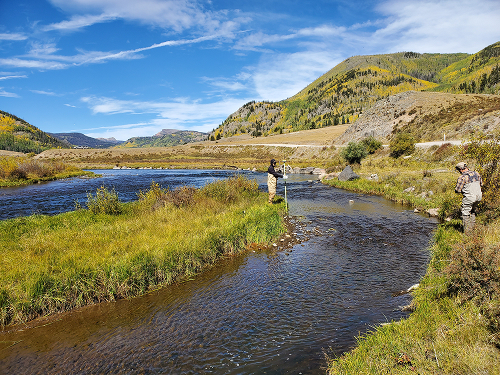
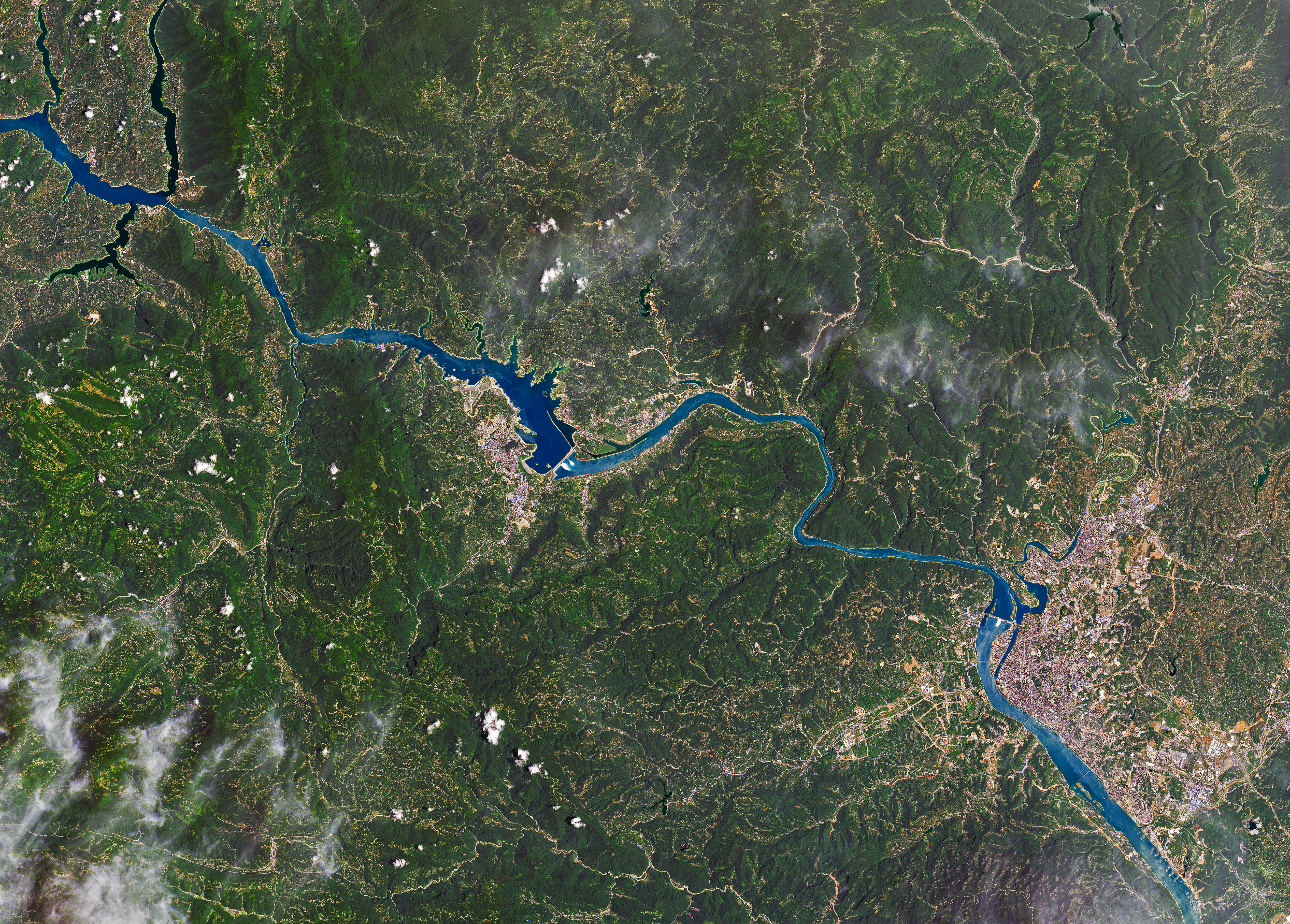
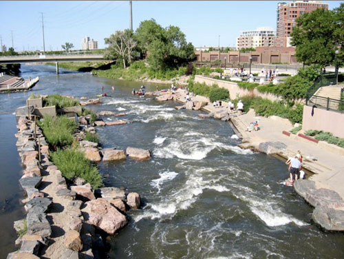
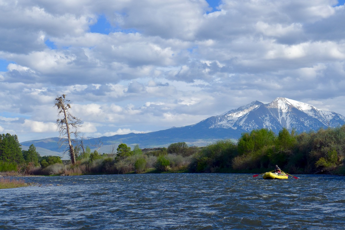
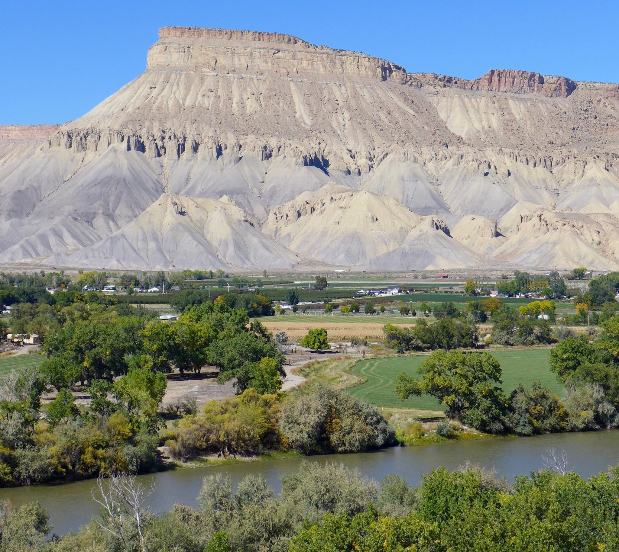
On Saturday, August 1, Colorado Water Trust, Grand Valley Water Users Association, and Orchard Mesa Irrigation District will initiate their implementation of an agreement that will deliver 877 acre-feet of water to the Grand Valley Power Plant and the 15-Mile Reach of the Colorado River above its confluence with the Gunnison River near Grand Junction, Colorado this summer. Grand Valley Water Users Association and Orchard Mesa Irrigation District identified available capacity in their water delivery system for Colorado Water Trust to deliver water decreed for power generation through the Grand Valley Power Plant, from where it subsequently returns to the 15-Mile Reach. This delivery will mark the second execution of an innovative agreement that Colorado Water Trust, Grand Valley Water Users Association, and Orchard Mesa Irrigation District entered last year with assistance from the Upper Colorado Endangered Fish Recovery Program and the Bureau of Reclamation.

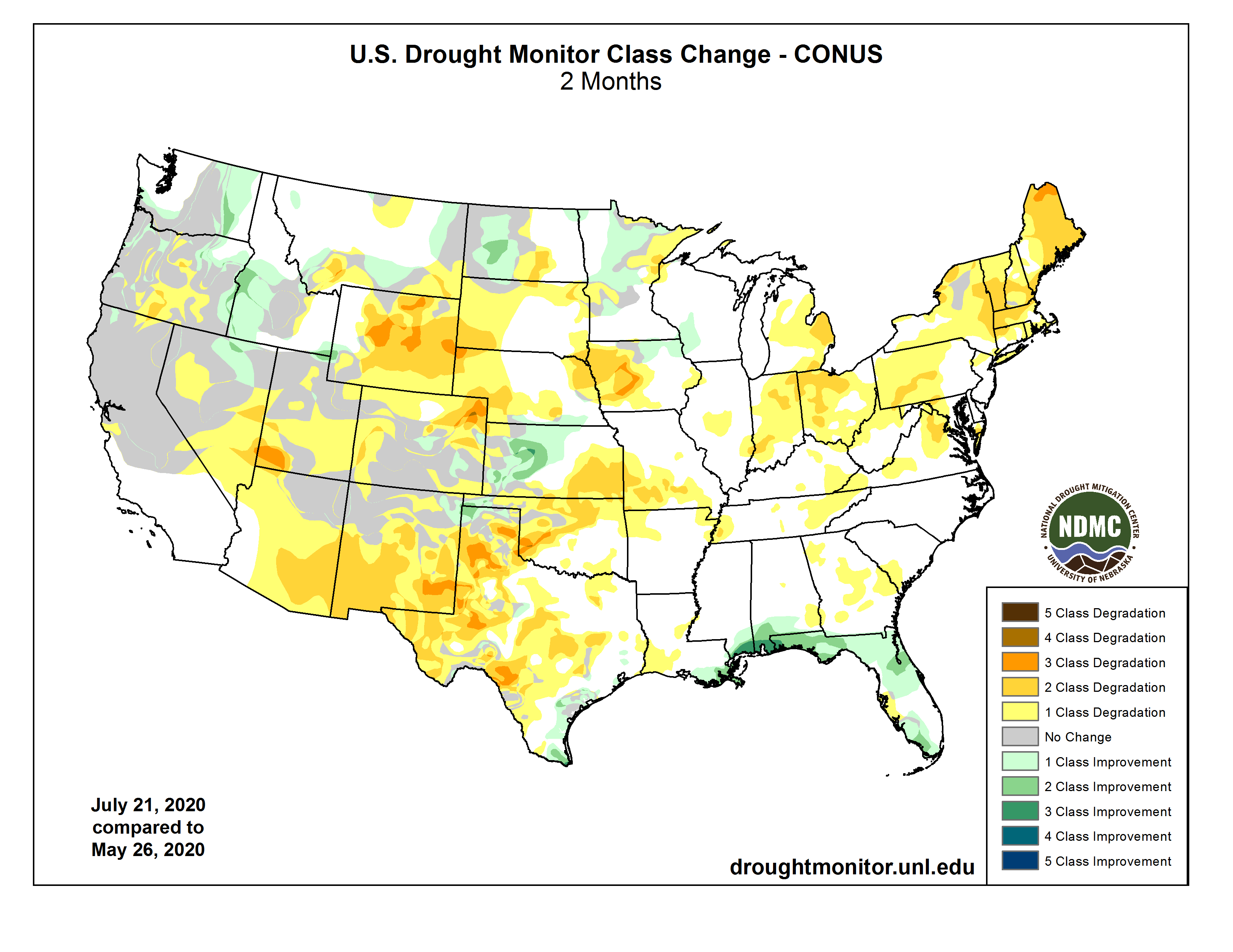
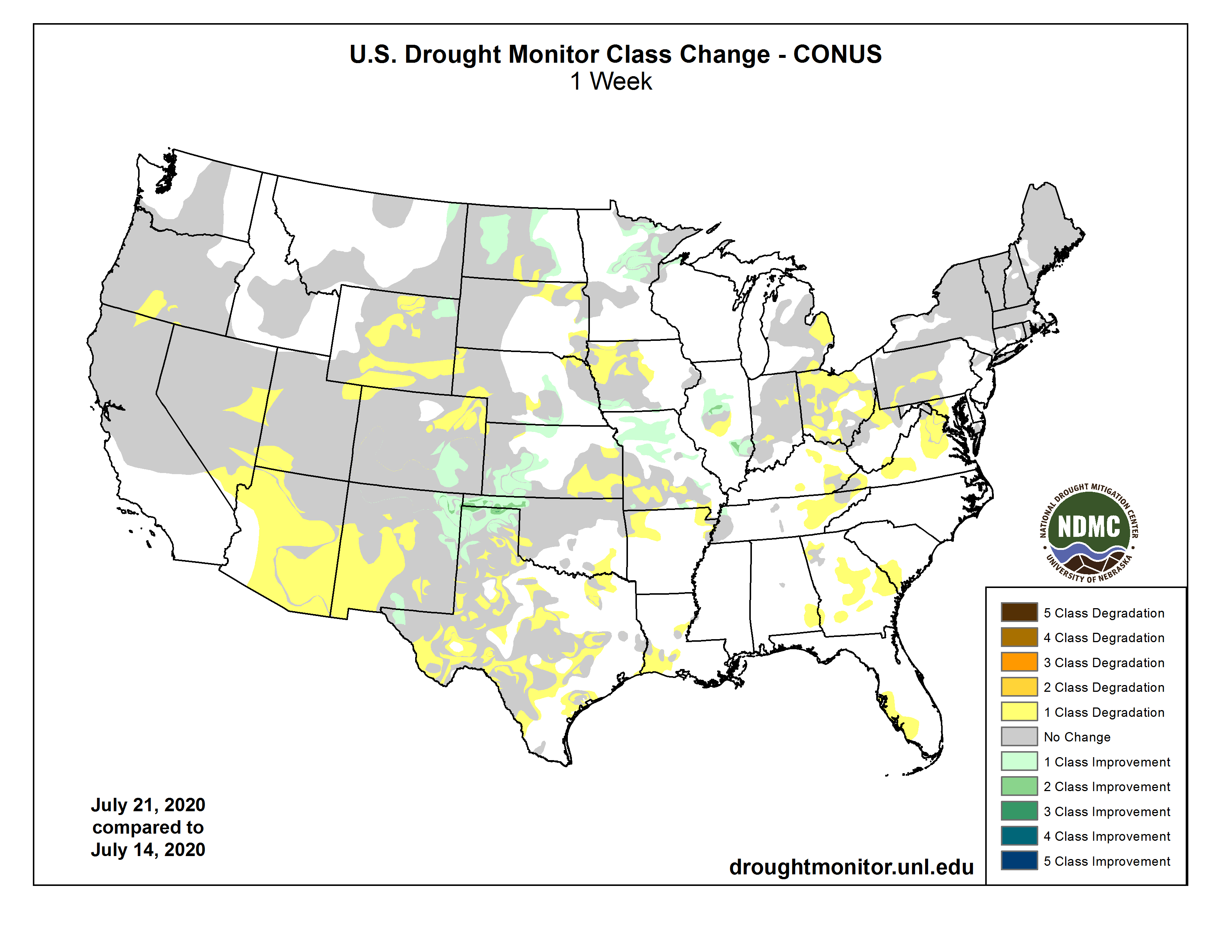
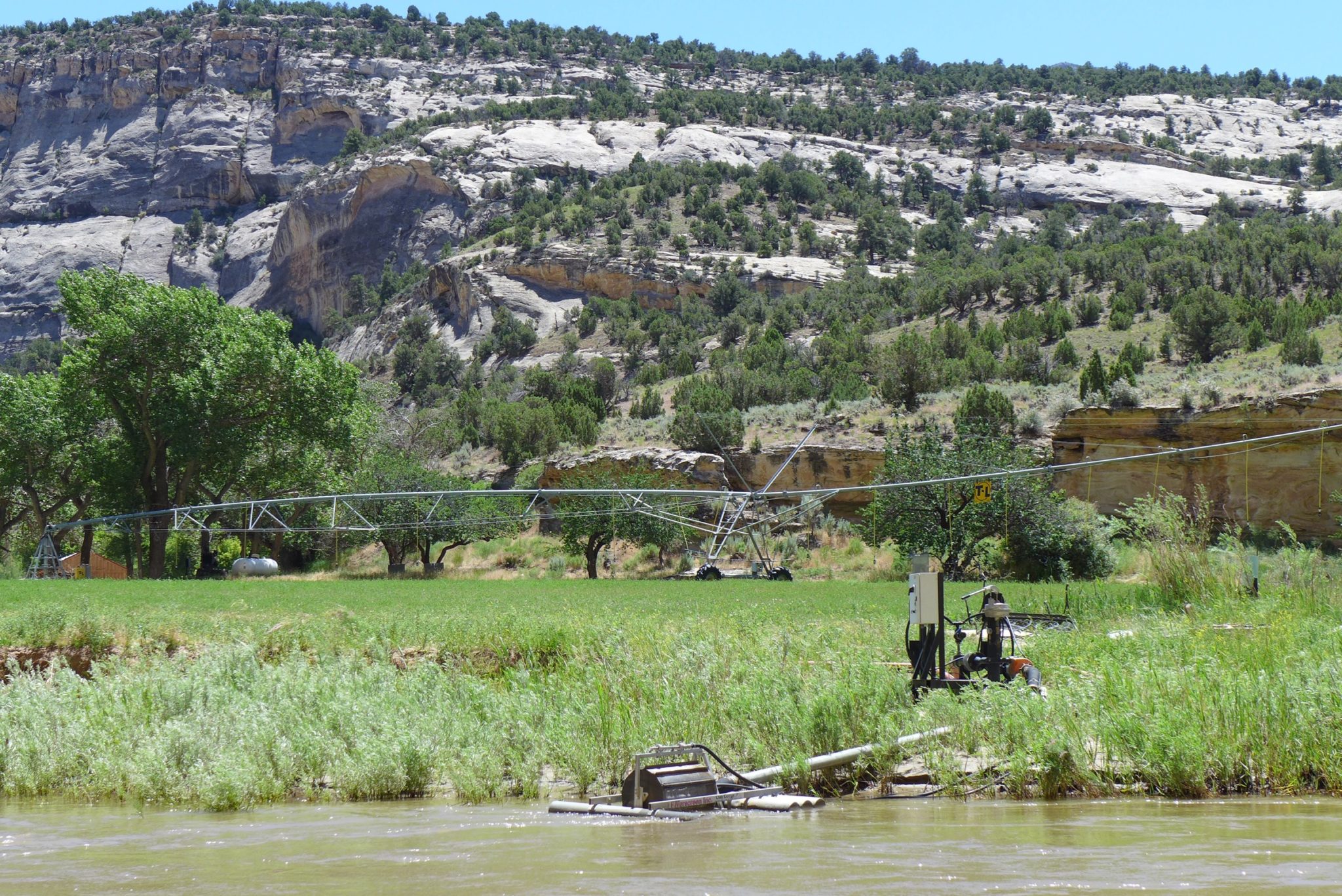
The agreement furthers common goals of streamflow restoration for the 15-Mile Reach and takes steps toward unlocking a $425,000 grant from Walton Family Foundation to renovate the aging Grand Valley Power Plant. Thanks to donor support, Colorado Water Trust has purchased stored water from the Colorado River District. That water will be released from Ruedi Reservoir to the Colorado River for use in the power plant and to increase 15-Mile Reach flows to support four species of endangered fish including the Colorado Pikeminnow, Humpback Chub, Bonytail, and Razorback Sucker.

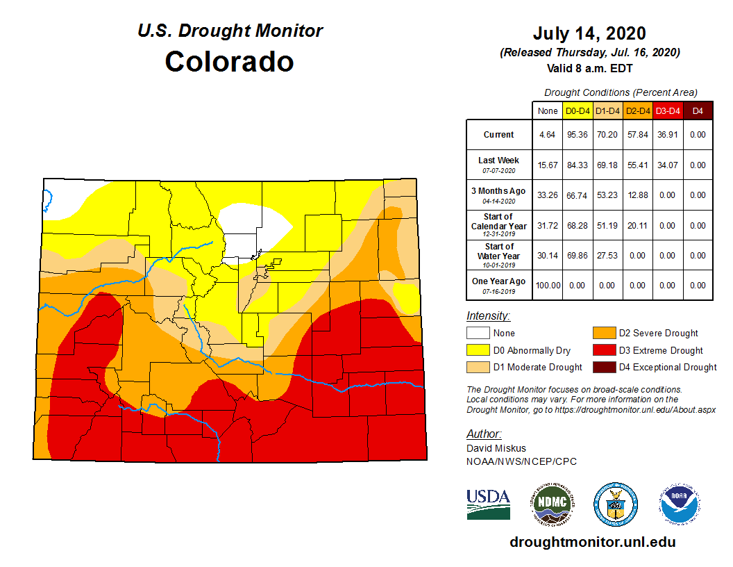
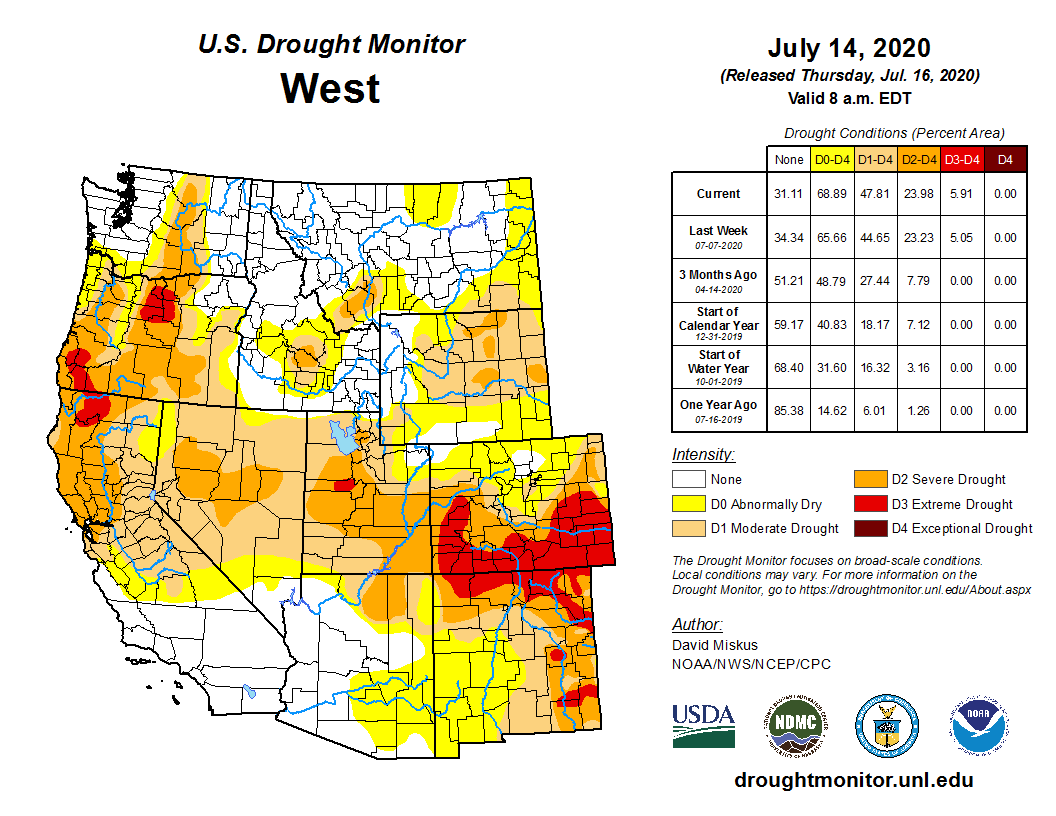
“We are so grateful to Grand Valley Water Users Association and Orchard Mesa Irrigation District for coordinating with us to boost flows in the 15-Mile Reach. Seeing the project work for a second year in a row proves the lasting success of our partnerships, and it’s particularly important to the fish this year, with flows as low as they are.” says Kate Ryan, Senior Staff Attorney for Colorado Water Trust.

This is the second time in the past two summers that Colorado Water Trust purchased water stored in Ruedi Reservoir for release to the 15-Mile Reach of the Colorado River to help maintain healthy streamflow and water temperatures. Purchases since 2019 will result in delivering over 1200 acre-feet of water to the Colorado River. Colorado Water Trust works closely with Grand Valley Water Users Association and Orchard Mesa Irrigation District to identify when there is available capacity in the power plant. Colorado Water Trust also works closely with the Upper Colorado River Endangered Fish Recovery Program to determine when the 15-Mile Reach needs supplemental water most to support the fish. When these two conditions overlap, Colorado Water Trust releases the water purchased out of storage for delivery to the power plant and then the 15-Mile Reach.

“Orchard Mesa Irrigation District and the Grand Valley Water Users Association appreciate the Colorado Water Trust’s facilitation of this agreement–it benefits our two organizations at the Grand Valley Power Plant, and the many other water users who support flows through the 15-Mile Reach. We believe these kinds of collaborative efforts to be of great value to the people of Colorado, the Colorado River, and the fish,” says Mark Harris, General Manager of Grand valley Water Users Association.

“Maintaining adequate flows for endangered fish through the 15-Mile Reach is possible only because of the extraordinary cooperation our Recovery Program enjoys from multiple partners and stakeholders. We are delighted to add the Colorado Water Trust to that mix of cooperators. This year, in light of unusually low flow conditions in the Colorado River, the additional water made available through this leasing arrangement is especially welcome,” says Donald Anderson, Hydrologist and Instream Flow Coordinator for the Upper Colorado River Endangered Fish Recovery Program.

The Roaring Fork Conservancy also helps to inform Colorado Water Trust of conditions on the Fryingpan and Roaring Fork Rivers to so that releases will complement flows on the stream sections between Ruedi Reservoir and the Colorado River. This year, the water released from Ruedi Reservoir will serve a few purposes before it supports the health of endangered, native fish in the Colorado River in the 15-Mile Reach. The water will bring flows in the Fryingpan River closer to their average, and will cool water temperatures on the Roaring Fork River. Finally, on the Colorado River, the water will generate hydropower, helping to produce clean energy.

“Flowing rivers are an economic engine in Colorado, providing immense value to irrigators, drinking water providers, and recreation across the state,” says Todd Reeve, CEO of Bonneville Environmental Foundation and Director of Business for Water Stewardship. “It is for this reason that we are seeing more and more corporate funders step forward to invest in innovative projects like this one that help keep the rivers in Colorado flowing.”

Essential to the project’s success are dedicated donors: Bonneville Environmental Foundation, Coca Cola, Colorado Water Trust donors, and Daniel K. Thorne Foundation. Without these generous donations and the collaborative work of local and state agencies, water releases to support the health of the 15-Mile Reach of the Colorado River would not be possible.

ABOUT COLORADO WATER TRUST: Colorado Water Trust is a statewide nonprofit organization that works collaboratively with partners all across Colorado on restoring flow to Colorado’s rivers in need using solutions that benefit both the people we work with and our rivers. Since 2001, we’ve restored 12 billion gallons of water to rivers and streams across the state.

This map shows the 15-mile reach of the Colorado River near Grand Junction, home to four species of endangered fish. Water from Ruedi Reservoir flows down the Fryingpan River and into the Roaring Fork, which flows into the Colorado River in Glenwood Springs. Map credit: CWCB

@EPA proposes permanent mine waste dump site north of #Silverton — The #Durango Herald #AnimasRiver #ColoradoRiver #COriver

The town of Silverton, Colorado, USA as seen from U.S. Route 550. By Daniel Schwen – Own work, CC BY-SA 4.0, https://commons.wikimedia.org/w/index.php?curid=10935432

From The Durango Herald (Jonathan Romeo):

Project needs approval from Sunnyside Gold, a company potentially on hook for costs

It appears the Environmental Protection Agency has found a place for long-term storage of mine waste near Silverton.

Mayflower Mill

The EPA announced this week it is proposing a waste repository for the Bonita Peak Mining District Superfund site on top of the existing tailings impoundment near the Mayflower Mill, about 2 miles northeast of Silverton off County Road 2.

The site, EPA officials say, would serve as a long-term option to store waste that is generated from Superfund cleanup actions, as well as sludge from the water treatment plant that takes in discharges from the Gold King Mine.

“It’s going to be there for the long haul to accommodate any waste we’ll need to remove,” said Christina Progess, the EPA’s lead for the Superfund site.

The proposal comes with one caveat, however: The property is owned by Sunnyside Gold Corp. The EPA has asked for approval from Silverton’s last operating mining company and has yet to hear back.

Gina Myers, a spokeswoman for Sunnyside Gold, said in an email to The Durango Herald that “SGC … had previously offered EPA the use of Mayflower ground for storage of sludge from the underutilized treatment plant.”

Myers did not clarify whether Sunnyside Gold will allow EPA access or not.

The need for a centrally located, permanent dump site for mine waste has been an ongoing issue for EPA ever since the Superfund was declared in fall 2016, about a year after the agency triggered a blowout at the Gold King Mine.

The water treatment plant constructed after the blowout generates up to 6,000 cubic yards of sludge a year – or about a football field buried in 3 feet of muck – and there’s little room on-site for storage. And in the future, the EPA will need a place to take waste removed from other projects…

In August 2019, Sunnyside Gold offered the EPA access to its property at the Mayflower tailings repository, a large series of four impoundments of historic mine waste rock that operated until the early 2000s.

“(The site) is an ideal and proven site for a repository for the water-treatment plant, and, in the interest of good faith and improving water quality, SGC has granted EPA access for this evaluative work,” the company said at the time.

Progess said the EPA sent Sunnyside Gold a consent for access request and hopes to hear of a final decision by mid-August…

If access were granted, the EPA would start a phased approach at the Mayflower tailings, Progess said. A liner would be placed on top of the existing piles for the new waste, which would then be capped.

All told, the EPA’s plan would have the capacity to store up to 609,000 cubic yards of mine waste and sludge. Use of the site, however, would vary year to year, depending on current projects and need…

The Mayflower tailings are suspected of leaching heavy metals into the Animas River, which has prompted Sunnyside Gold to conduct its own multi-year investigation into the matter.

Progess said the investigation remains ongoing, and the EPA would use a different, more stable location at Impoundment 1 on the site to store its waste to begin with. She said leaching is suspected at Impoundment 4.

“We feel comfortable starting the work at Impoundment 1,” she said. “That will allow us years of use while the investigation on Impoundment 4 can continue.”

The public can comment on the proposed plan until Aug. 27. A virtual public hearing will be held at 6 p.m. Aug 11.

Progess said the EPA hopes to have the site constructed and ready for use by fall 2021, about the time storage at the water-treatment plant for the Gold King Mine is expected to reach capacity.

The EPA’s wastewater treatment plant near Silverton, Colorado, on Thursday, Oct. 16, 2015 — photo via Grace Hood Colorado Public Radio

Report: The economic benefits of #Colorado’s eastern plains #renewable energy industry #ActOnClimate #KeepItInTheGround

Storm clouds are a metaphor for Republican strategy to politicize renewable energy for the November 2020 election. Photo credit: The Mountain Town News/Allen Best

Click here to read the report. Here’s the executive summary:

Electricity generation and consumption has changed rapidly over the last ten years, driven by steep price drops for generation and technological innovations impacting utilities and consumers alike. After decades of research and development, market development, and production efficiency gains, renewable energy is now a proven and cost- effective way to deliver electricity across the country.

There is concern that the COVID-19 pandemic could negatively impact current and planned renewable energy facility investments and construction. Indeed, the pandemic is creating challenges to both supply and demand. While the risk to current and planned projects from the pandemic is unclear at this time, existing facilities should not be affected. The expectation is that these facilities will continue to provide a steady source of jobs and tax revenue to communities across the eastern plains. These benefits will prove valuable to communities as the pandemic takes a toll on many other sectors including leisure and hospitality, retail, and health care.

For Colorado’s eastern plains communities, renewable energy and advanced energy technologies have brought thousands of jobs, and investment has supported communities across the region. The intent of this study is to profile the renewable energy industry in Colorado’s eastern plains and measure the economic benefits it provides in terms of construction, investment, employment, and business activity. For the economic benefits estimates, the study not only details construction and operations for the region’s existing renewable facilities but offers a prospective look at the benefits realized by 2024. The following bullets highlight key findings and estimates of the size and growth of these benefits.

  • In 2018􏰁, Colorado’s eastern plains comprised 􏰂5.5 percent of the renewable energy capacity in the state and represented all the state’s wind energy and about 55 percent of the state’s solar capacity.
  • Renewable energy capacity has expanded rapidly in Colorado’s eastern plains. In 2010, there was 1,253 MW of nameplate capacity in nine wind facilities in Colorado’s eastern plains. By the end of 2020, another 3,707 MW of wind and solar capacity is expected to be operable in the eastern plains. By 2024, the eastern plains’ renewable capacity is expected to expand by more than 22 percent, adding 1,109 MW and bringing the region’s wind and solar capacity to 6,069 MW.
  • By 2024, the state is expected to add its largest solar facilities and first utility-scale battery storage components with the construction of the 250-MW Neptune solar plant and the 200-MW Thunder Wolf solar plant.
  • Renewable and Advanced Energy Employment

  • From 2015 to 2019, renewable and advanced energy employment increased by more than 40 percent in Colorado’s eastern plains, growing to an estimated 6,334 workers in 366 business establishments.
  • Wind is critical to the eastern plains’ employment base, combined with wind facility installation, operations, and maintenance, wind technologies employ about 70 percent of renewable and advanced energy workers on the eastern plains.
  • Since 2015, job opportunities for solar installation have increased significantly in the eastern plains. Solar installation jobs have risen from an estimated 42 jobs in 2015 to 151 jobs in 2019.
  • Economic Benefits of Construction and Investment

  • Renewable energy development on Colorado’s eastern plains has brought significant investment to the state. From 2000 to 2024, there will have been an estimated $9.4 billion in construction and investment activity in the eastern plains. By 2024, investment will have increased by 75 percent since 2016.
  • Although many purchases for renewable energy facilities are made out-of-state, Colorado has benefited from local spending on equipment, construction materials, design, project management, planning, and local workers. As a result, the direct economic benefit in Colorado of construction and investment in the eastern plains’ renewable facilities will total an estimated $2.7 billion from 2000 to 2024.
  • By 2024, thousands of Coloradans will have benefited from work supported by renewable energy investments. An estimated 3,158 state workers will be directly employed in the construction of the facilities from 2000 to 2024. In addition, components for a handful of the eastern plains’ wind facilities have either been manufactured or will be manufactured at Vestas plants in the state. These purchases will directly employ another 2,386 workers by 2024.
  • Beyond direct output and employment, renewable facility construction and investment has supported many ancillary industries throughout the eastern plains since 2000. Combined, the total direct and indirect benefits of renewable energy development in Colorado’s eastern plains will be an estimated 􏰃5.􏰂 billion in total output ($2.7 billion direct output + $3.1 billion indirect and induced output) produced by 12,819 employees (5,544 direct employees + 7,275 indirect employees) earning a total of about $706.9 million ($355.6 million direct earnings + $351.3 million indirect earnings) from 2000 to 2024
  • Construction benefits are temporary, occurring only during construction. Economic Benefits of Annual Operations by 2024
  • The ongoing operations and maintenance of renewable facilities on Colorado’s eastern plains support long- term employment opportunities for hundreds of people in the state. By 2024, renewable facilities will support the direct employment of an estimated 352 workers.
  • By 2024, wind energy facilities will provide farmers, ranchers, and other landowners on Colorado’s eastern plains with $15.2 million in annual lease payments, up from an estimated $7.5 million in 2016.
  • Renewable energy projects will contribute an estimated $23.1 million in annual property tax revenue throughout districts in the eastern plains by 2024, up from an estimated $7.2 million in 2016.
  • Therefore, the total direct and indirect benefits in Colorado of annual renewable energy operations in the eastern plains will be an estimated $388.6 million in total output ($214.6 million direct output + $174 million indirect and induced output) produced by 1,089 employees (352 direct employees + 737 indirect employees) earning a total of about $56.7 million ($21.9 million direct earnings + $34.8 million indirect earnings) by 2024.
  • These benefits are likely to occur annually assuming similar business conditions and project parameters.
  • Opinion: #ColoradoRiver water use and states’ rights — The St. George Spectrum

    From The St. George Spectrum (David Clark):

    All Colorado River basin states have the right to develop and use their water, in accordance with the compacts that form the basis for the Law of the River. They can do so whenever in time the need arises.

    Utah is entitled to 23% of the water available to the Upper Basin. Unlike the Lower Basin states (Nevada, Arizona and California), the Upper Basin states (Colorado, New Mexico, Wyoming and Utah) receive a percentage of available water rather than a set acre-foot volume so their water supplies are adjusted based on actual flows. Utah’s annual compact allocation is 1.725 million acre feet, but its annual reliable supply (or the amount of water available for development after considering climate variability) is approximately 1.4 million acre feet — or, 80% of what was allocated to the state in the compacts.

    Utah currently uses less than 1 million acre feet of Colorado River water — well under its annual reliable supply. Utah’s rapid population and economic growth has necessitated that the state develop its available water resources. Utah’s development of its currently unused Colorado River water complies with the law and does not jeopardize other state allocations.

    For nearly two decades, Utah has studied the Lake Powell Pipeline (LPP), a $1.4 billion project that would deliver 6% of its annual reliable supply of river water to the state’s driest and fastest-growing region — Washington County.

    Washington County has reduced its per-capita use by 30% while nearly doubling its population from 2000-2018. Additional conservation reductions are planned. County water use is comparable to other desert communities when calculated using similar methodologies.

    The Bureau of Reclamation recently released its draft Environmental Impact Study on the LPP and determined that the project is needed, the water is available and there are few environmental impacts.

    Individuals who suggest Colorado River basin states should “challenge” Utah’s use of its water fail to understand the Law of the River, which authorizes each state to develop and use its respective share.

    Proposed Lake Powell pipeline. Map via the City of St. George.

    #Drought news: Moderate to extreme drought covers most of #Colorado and #WY

    Click on a thumbnail graphic below to view a gallery of drought data from the US Drought monitor.

    Click here to go to the US Drought Monitor website. Here’s an excerpt:

    This Week’s Drought Summary

    High pressure dominated the southern half of the contiguous U.S. (CONUS) again during this U.S. Drought Monitor (USDM) week. Upper-level weather systems tracked across the U.S.-Canadian border, dragging surface lows and fronts along with them. The High brought hot temperatures to much of the South, East, and West, with daily maximum temperatures exceeding 90 degrees F every day. The fronts brought cooler temperatures to the Upper Midwest at the beginning of the week, but maximum temperatures began to exceed 90 degrees across the Plains and eastward as the week wore on. The hot temperatures increased evapotranspiration (ET) which dried soils and stressed crops and other vegetation. This was seen in ET models such as the EDDI and ESI and several soil moisture models, satellite observations of soil moisture, and agricultural field reports. As noted by the U.S. Department of Agriculture (USDA) on July 27, 50 percent or more of the topsoil moisture was short or very short (dry or very dry) in states across the Northeast, Midwest, Southeast, southern Plains, southern to central Rockies, and Far West. For the nation as a whole, 37 percent of the topsoil moisture and 35 percent of the subsoil moisture was short or very short, and 30 percent of the pasture and rangeland was in poor to very poor condition. Drought or abnormal dryness expanded or intensified across parts of the West, Midwest, Southeast, and Northeast where little to no rain fell and 30- to 90-day precipitation deficits mounted. But locally heavy rainfall was generated by the fronts in parts of the Plains, Midwest, and East. Heavy rain also fell across southern Texas when Hurricane Hanna struck, and Hurricane Douglas graced parts of Hawaii with beneficial rain. Where the rain fell on drought or abnormally dry areas in these regions, contraction occurred…

    High Plains

    Areas of 2+ inches of rain occurred over parts of Nebraska and Kansas and a few parts of the Dakotas, while parts of Colorado had an inch or more of rain. But little to no rain fell in a few areas of Kansas, across parts of Nebraska and Colorado, across even more of the Dakotas, and across most of Wyoming. Contraction of abnormal dryness and moderate to extreme drought occurred across Kansas and parts of Colorado; abnormal dryness and moderate to severe drought contracted in parts of Nebraska; and abnormal dryness and moderate drought were trimmed in parts of the Dakotas. But abnormal dryness or moderate drought expanded in parts of Colorado and the Dakotas, and abnormal dryness and moderate to severe drought expanded in Nebraska. Wyoming saw expansion of abnormal dryness and moderate to extreme drought. Moderate to extreme drought covers most of Colorado and Wyoming…

    West
    The Southwest Monsoon sparked some showers over New Mexico, with a few showers making an appearance over parts of Arizona, Utah, Idaho, and Montana, but most of the West received little to no rain this week. Severe drought disappeared from southwest Montana, but the rain that fell in New Mexico was not enough to improve conditions there. Severe to extreme drought expanded in New Mexico; moderate to extreme drought expanded in Utah, and Nevada; moderate to severe drought grew in Arizona; abnormal dryness and moderate to severe drought added acres in Montana; and moderate drought expanded in northeast California and adjacent Nevada…

    South

    Central Oklahoma was inundated with heavy frontal rain while Hanna brought heavy rain to the Gulf Coast from southern Texas to Mississippi. Rainfall exceeded 3 inches in these areas, with locally heavier amounts. Parts of Arkansas, Tennessee, and northern Texas received an inch or more of rain. But little to no rain occurred in a large swath from southwest Texas to western Tennessee and northern Mississippi. Abnormal dryness and moderate to extreme drought contracted, especially in central Oklahoma and the Texas panhandle. Abnormal dryness contracted in parts of Tennessee and Louisiana. But abnormal dryness expanded in parts of eastern Oklahoma and parts of Arkansas, Mississippi, and Tennessee. Abnormal dryness and moderate to extreme drought expanded in other parts of Texas…

    Looking Ahead

    For July 30-August 3, the ridge of high pressure shifts to the West with a trough setting up in the upper atmosphere over the eastern half of the CONUS. Little to no rain is forecast for most of the West, with half an inch or less across parts of the Rockies and only a couple inches stretching across the middle of New Mexico. But an inch or more of rain is expected from the central Plains to southern Appalachians and southern Great Lakes, with heavy rain (4 inches or more) widespread from Missouri and northern Arkansas to Kentucky, Indiana, and western North Carolina. A tropical system is predicted to sideswipe the East Coast, dumping an inch or more of rain across Florida to the Mid-Atlantic states, 3 or more inches over southern Florida, and up to 2 inches over eastern North Carolina and southeast Virginia. Half an inch or less of rain is expected from Texas to southwest Georgia, and across the northern Plains to wester Great Lakes. In the Northeast, predicted precipitation amounts range from nearly 2 inches in western New York to a tenth of an inch along coastal New England. The ridge will keep temperatures warmer than normal in the West while the trough brings cooler-than-normal temperatures to much of the CONUS east of the Rockies. The outlook for August 4-8 calls for a greater than average chance of wetter-than-normal conditions along the East Coast, in the northern Plains, across Deep South Texas, and most of Alaska. Odds favor drier-than-normal conditions across most of the West, the southern Plains, the central Gulf of Mexico coast to the Great Lakes, and over northern Alaska. Warmer-than-normal temperatures are likely across the Southwest and along the immediate East Coast, while cooler-than-normal temperatures are likely to dominate from the Plains to Appalachians, in the Pacific Northwest, and across most of Alaska.

    US Drought Monitor one week change map ending July 28, 2020.

    Navajo Nation Sees Farming Renaissance During #Coronavirus Pandemic — KUNC #COVID19

    The $1 billion Navajo-Gallup water pipeline will take 12 years to build and could serve as many as 250,000 people a year by 2040, officials say. Image via Cronkite News.

    From KUNC (Laurel Morales):

    Historically Navajos have lived off the land. But decades of assimilation, forced relocation and dependence on federal food distribution programs changed that.

    Navajo farmer Tyrone Thompson is on a mission to help people return to their roots. He’s even taken to social media to teach traditional farming techniques.

    In a recent video he demonstrates how to layer organic matter to turn dry clay into rich fertile soil.

    The U.S. Department of Agriculture calls the Navajo Nation a food desert. People travel up to 40 miles to get their groceries. But Thompson says they don’t have to.

    “As we see the shelves emptying of food and toilet paper we kind of reconnect to our roots,” Thompson says. “Some of the tools that were given by our elders and our ancestors — our planting stick and our steering sticks — those are our weapons against hunger and poverty and sickness.”

    Yes, kids can get COVID-19 – 3 pediatricians explain what’s known about #coronavirus and children — The Conversation #COVID19


    Children are at risk of getting sick from coronavirus and need to practice social distancing and mask wearing too.
    AP Photo/Seth Wenig, File

    Kathryn Moffett-Bradford, West Virginia University; Martin Weisse, West Virginia University, and Shipra Gupta, West Virginia University

    We are three pediatric infectious disease specialists who live and work in West Virginia. The West Virginia University health system serves 400,000 children and according to our internal data, to date, 2,520 children up to 17 years of age have been tested for the coronavirus. Sixty-seven of them tested positive and one became sick enough to be admitted to the hospital.

    We are asked almost daily about children and COVID-19: Do they get COVID-19? Should they attend day care or school, play sports, see friends and attend summer camps? What are the risks to themselves and to others?

    Based on current research and our own experiences, it would seem that kids 17 years old and younger face little risk from the coronavirus. Nearly all children have asymptomatic, very mild or mild disease, but a small percentage of children do get very sick. Additionally, there is evidence that children can spread the virus to others, and with huge outbreaks occurring all across the U.S, these realities raise serious concerns about school reopenings and how children should navigate the pandemic world.

    A doctor in personal protective gear treating a young child inside of an ambulance.
    Though somewhat rare, children can get severely ill from the coronavirus and a few have died.
    John Moore/Getty Images News via Getty Images

    Children at risk

    When considering the role of children in this pandemic, the first question to ask is whether they can get infected, and if so, how often.

    Of the 149,082 reported cases of COVID-19 in the U.S. as of late April, only 2,572 – 1.7% – were children, despite children making up 22% of the U.S population.

    But current research shows that children are physiologically just as likely to become infected with SARS-CoV-2 as adults. This discrepancy between case numbers and biological susceptibility may be due to the fact that children generally generally have minimal to mild symptoms when infected with the coronavirus and are therefore less likely to get tested. It also may be that children in general have had less exposure to the virus compared to adults. Kids aren’t going to work, they are probably going out to stores less than adults, and in the states that had relaxed quarantine measures, they aren’t going out to bars or gyms.

    Even though children are less likely to get sick from the coronavirus, they are definitely not immune. Data shows that children less than one year old and those with underlying conditions are the most likely to be hospitalized. These kids usually experience the respiratory distress commonly associated of COVID-19 and often need oxygen and intensive care support. As of July 11, 36 kids 14 or younger had died from the virus.

    In addition to the typical COVID-19 cases, recently there have been some frightening reports of children’s immune systems going haywire after they are exposed to SARS-CoV-2.

    Notable are reports of Kawasaki disease. Normally, Kawasaki disease affects toddlers and preschool children, causing prolonged high fever, rash, eye redness, mouth swelling and swelling of arteries in the heart. The vast majority of children that get Kawasaki disease survive when given treatments that bring down the swelling, but sadly, a few children have died from it, after exposure to the coronavirus led to the disease. Physicians don’t know what causes Kawasaki disease normally or why a coronavirus infection could trigger it.

    [You’re too busy to read everything. We get it. That’s why we’ve got a weekly newsletter. Sign up for good Sunday reading. ]

    In the past few months, there have also been reports of some children, after becoming infected with the coronavirus, experiencing fever and rash along with a life-threatening blood pressure drop and sudden severe heart failure. The children and teenagers with this COVID-19-related shock syndrome – now named multisystem inflammatory syndrome in children, or MIS-C – are older than those doctors usually see with Kawasaki disease. Experts think these two illness are not the same, despite having similar features and similar treatments.

    A group of kids without masks gather around a teacher wearing a mask outside.
    Research shows that kids are able to spread the coronavirus – older children more easily than younger children.
    AP Photo/Ted S. Warren

    Children as spreaders

    So if kids can catch the coronavirus, the next important question is: How easily can they spread it? Since children have milder symptoms, some experts think that children are probably not the drivers of the COVID-19 pandemic. Additionally, recent research has shown that most kids who catch the coronavirus get it from their parents, not other children.

    Small children may have weaker coughs and therefore would release fewer infectious virus particles into their environment. A recent study from South Korea found that while young children seem less able to spread the disease compared to adults, children 10 to 19 years old spread the virus at least as well as the adults do. The lack of evidence that children are major sources of transmission may simply be because the pathway of infection was interrupted due to the nationwide school closures in the spring. As children resume more of their normal daily activities – like school, sports and day care – we just might find the answer to how easily children spread this dangerous virus.

    Two boys in a classroom wearing masks, with one raising his hand.
    Should schools reopen if children can get sick from and spread the coronavirus?
    AP Photo/LM Otero, File

    So what now?

    The evidence clearly shows that all people, regardless of age, can get infected by SARS-CoV-2. While research shows that kids are more resistant to severe illness from the coronavirus, they are still at risk and can spread the virus even if they themselves are not sick.

    Given all this information, a question naturally arises: Should schools reopen in the coming weeks? In places where transmission rates are low, reopening schools could be a viable option. But at the present time, in the U.S., new case numbers are surging in most states. This requires a more nuanced approach than a full-scale reopening of schools.

    Since young children face low risk of getting seriously ill, are less likely to spread the disease and benefit greatly from in-person interactions, we believe in-school learning should be considered. Opening schools for elementary school children, and coming up with increasingly online options for the older grades, could be one way to approach this thorny problem.The Conversation

    Kathryn Moffett-Bradford, Professor of Pediatrics, Division Chief of Pediatric Infectious Diseases, West Virginia University; Martin Weisse, Professor of Pediatrics, West Virginia University, and Shipra Gupta, Assistant Professor of Pediatric Infectious Disease, West Virginia University

    This article is republished from The Conversation under a Creative Commons license. Read the original article.

    @USBR to Host Ruedi Reservoir Water Operations Public Meeting #ColoradoRiver #COriver #aridification

    From email from Reclamation (Elizabeth Jones):

    The Bureau of Reclamation has scheduled the annual public meeting to discuss the Ruedi Reservoir Water Operations for the 2020 water year.

    The meeting will be held on August 5, 2020, from 6:30-8:00 pm using Webex (Webex is a web-based platform that hosts online meetings with HD video, audio and screen sharing.)

    To join from a mobile device (attendees only):
    Dial: 1-415-527-5035, 1992510741## US Toll

    To join by phone:
    Dial: 1-415-527-5035 US Toll

    The meeting will provide an overview of Ruedi Reservoir’s 2020 projected operations for late summer and early fall, which are key tourist seasons in Basalt. Also, representatives of the Colorado Water Conservation Board and the U.S. Fish and Wildlife Service will give a presentation on the upcoming implementation of the Ute Water Conservancy District and Garfield County leases of Ruedi Reservoir water to the Board for instream flow use in the 15-Mile Reach of the Colorado River. The meeting will include a public question and answer session.

    For more information, please contact Tim Miller, Hydrologist, Eastern Colorado Area Office, by phone or e-mail: (970) 290-4895, or tmiller@usbr.gov.

    The blue expanse of Ruedi Reservoir as seen from the air. Students with the Carbondale-based Youth Water Leadership Program took to the air with EcoFlight to see how people have modified water in the Roaring Fork watershed. Photo credit: Heather Sackett/Aspen Journalism

    Interview: ‘Not Another Decade to Waste’ — How to Speed up the Clean Energy Transition — The Revelator #ActOnClimate #KeepItInTheGround

    Wind turbines, Weld County, 2015. Photo credit: Allen Best/The Mountain Town News

    From The Revelator (Tara Lohan):

    Energy policy expert Leah Stokes explains who’s pushing climate delay and denial — it’s not just fossil fuel companies — and what we need to do now

    The first official tallies are in: Coronavirus-related shutdowns helped slash daily global emissions of carbon dioxide by 14% in April. But the drop won’t last, and experts estimate that annual emissions of the greenhouse gas are likely to fall only about 7% this year.

    After that, unless we make substantial changes to global economies, it will be back to business as usual — and a path that leads directly to runaway climate change. If we want to reverse course, say the world’s leading scientists, we have about a decade to right the ship.

    That’s because we’ve squandered a lot of time. “The 1990s and the beginning of the 2000s were lost decades for preventing global climate disaster,” political scientist Leah Stokes writes in her new book Short Circuiting Policy, which looks at the history of clean energy policy in the United States.

    But we don’t all bear equal responsibility for the tragic delay.

    “Some actors in society have more power than others to shape how our economy is fueled,” writes Stokes, an assistant professor at the University of California, Santa Barbara. “We are not all equally to blame.”

    Short Circuiting Policy focuses on the role of one particularly bad actor: electric utilities. Their history of obstructing a clean-energy transition in the United States has been largely overlooked, with most of the finger-pointing aimed at fossil fuel companies (and for good reason).

    We spoke with Stokes about this history of delay and denial from the utility industry, how to accelerate the speed and scale of clean-energy growth, and whether we can get past the polarizing rhetoric and politics around clean energy.

    What lessons can we learn from your research to guide us right now, in what seems like a really critical time in the fight to halt climate change?

    What a lot of people don’t understand is that to limit warming to 1.5 degrees Celsius, we actually have to reduce emissions by around 7-8% every single year from now until 2030, which is what the emissions drop is likely to be this year because of the COVID-19 crisis.

    Lean Stokes. Photo credit: University of California Santa Barbara

    So think about what it took to reduce emissions by that much and think about how we have to do that every single year.

    It doesn’t mean that it’s going to be some big sacrifice, but it does mean that we need government policy, particularly at the federal level, because state policy can only go so far. We’ve been living off state policy for more than three decades now and we need our federal government to act.

    Where are we now, in terms of our progress on renewable energy and how far we need to go?

    A lot of people think renewable energy is growing “so fast” and it’s “so amazing.” But first of all, during the coronavirus pandemic, the renewable energy industry is actually doing very poorly. It’s losing a lot of jobs. And secondly, we were not moving fast enough even before the coronavirus crisis, because renewable energy in the best year grew by only 1.3%.

    Right now we’re at around 36-37% clean energy. That includes nuclear, hydropower and new renewables like wind, solar and geothermal. But hydropower and nuclear aren’t growing. Nuclear supplies about 20% of the grid and hydro about 5% depending on the year. And then the rest is renewable. So we’re at about 10% renewables, and in the best year, we’re only adding 1% to that.

    Generally, we need to be moving about eight times faster than we’ve been moving in our best years. (To visualize this idea, I came up with the narwhal curve.)

    How do we overcome these fundamental issues of speed and scale?

    We need actual government policy that supports it. We have never had a clean electricity standard or renewable portfolio standard at the federal level. That’s the main law that I write all about at the state level. Where those policies are in place, a lot of progress has been made — places like California and even, to a limited extent, Texas.

    We need our federal government to be focusing on this crisis. Even the really small, piecemeal clean-energy policies we have at the federal level are going away. In December Congress didn’t extend the investment tax credit and the production tax credit, just like they didn’t extend or improve the electric vehicle tax credit.

    And now during the COVID-19 crisis, a lot of the money going toward the energy sector in the CARES Act is going toward propping up dying fossil fuel companies and not toward supporting the renewable energy industry.

    So we are moving in the wrong direction.

    Clean energy hasn’t always been such a partisan issue. Why did it become so polarizing?

    What I argue in my book, with evidence, is that electric utilities and fossil fuel companies have been intentionally driving polarization. And they’ve done this in part by running challengers in primary elections against Republicans who don’t agree with them.

    Basically, fossil fuel companies and electric utilities are telling Republicans that you can’t hold office and support climate action. That has really shifted the incentives within the party in a very short time period.

    It’s not like the Democrats have moved so far left on climate. The Democrats have stayed in pretty much the same place and the Republicans have moved to the right. And I argue that that’s because of electric utilities and fossil fuel companies trying to delay action.

    And their reason for doing that is simply about their bottom line and keeping their share of the market?

    Exactly. You have to remember that delay and denial on climate change is a profitable enterprise for fossil fuel companies and electric utilities. The longer we wait to act on the crisis, the more money they can make because they can extract more fossil fuels from their reserves and they can pay more of their debt at their coal plants and natural gas plants. So delay and denial is a money-making business for fossil fuel companies and electric utilities.

    There’s been a lot of research, reporting and even legal action in recent years about the role of fossil fuel companies in discrediting climate science. From reading your book, it seems that electric utilities are just as guilty. Is that right?

    Yes, far less attention has been paid to electric utilities, which play a really critical role. They preside over legacy investments into coal and natural gas, and some of them continue to propose building new natural gas.

    They were just as involved in promoting climate denial in the 1980s and 90s as fossil fuel companies, as I document in my book. And some of them, like Southern Company, have continued to promote climate denial to basically the present day.

    But that’s not the only dark part of their history.

    Electric utilities promoted energy systems that are pretty wasteful. They built these centralized fossil fuel power plants rather than having co-generation plants that were onsite at industrial locations where manufacturing is happening, and where you need both steam heat — which is a waste product from electricity — and the electricity itself. That actually created a lot of waste in the system and we burned a lot more fossil fuels than if we had a decentralized system.

    The other thing they’ve done in the more modern period is really resisted the energy transition. They’ve resisted renewable portfolio standards and net metering laws that allow for more clean energy to come onto the grid. They’ve tried to roll them back. They’ve been successful in some cases, and they’ve blocked new laws from passing when targets were met.

    You wrote that, “Partisan polarization on climate is not inevitable — support could shift back to the bipartisanship we saw before 2008.” What would it take to actually make that happen?

    Well, on the one hand, you need to get the Democratic Party to care more about climate change and to really understand the stakes. And if you want to do that, I think the work of the Justice Democrats is important. They have primary-challenged incumbent Democrats who don’t care enough about climate change. That is how Alexandria Ocasio-Cortez was elected. She was a primary challenger and she has really championed climate action in the Green New Deal.

    The other thing is that the public supports climate action. Democrats do in huge numbers. Independents do. And to some extent Republicans do, particularly young Republicans.

    So communicating the extent of public concern on these issues is really important because, as I’ve shown in other research, politicians don’t know how much public concern there is on climate change. They dramatically underestimate support for climate action.

    I think the media has a really important role to play because it’s very rare that a climate event, like a disaster that is caused by climate change, is actually linked to climate change in media reporting.

    But people might live through a wildfire or a hurricane or a heat wave, but nobody’s going to tell them through the media that this is climate change. So we really need our reporters to be doing a better job linking people’s lived experiences to climate change.

    With economic stimulus efforts ramping up because of the COVD-19 pandemic, are we in danger of missing a chance to help boost a clean energy economy?

    I think so many people understand that stimulus spending is an opportunity to rebuild our economy in a way that creates good-paying jobs in the clean-energy sector that protects Americans’ health.

    We know that breathing dirty air makes people more likely to die from COVID-19. So this is a big opportunity to create an economy that’s more just for all Americans.

    But unfortunately, we really are not pivoting toward creating a clean economy, which is what we need to be doing. This is an opportunity to really focus on the climate crisis because we have delayed for more than 30 years. There is not another decade to waste.

    Tara Lohan is deputy editor of The Revelator and has worked for more than a decade as a digital editor and environmental journalist focused on the intersections of energy, water and climate. Her work has been published by The Nation, American Prospect, High Country News, Grist, Pacific Standard and others. She is the editor of two books on the global water crisis.
    http://twitter.com/TaraLohan

    Mainstem #ColoradoRiver call change July 29, 2020 #COriver

    The penstocks feeding the Shoshone hydropower plant on the Colorado River in Glenwood Canyon.

    From email from the Colorado Division of Water Resources (James Heath):

    This is a notification that the Shoshone Power Plant is going down to one unit and their call will be released from the stream. The Shoshone Outage Protocol will not operate due to the target flow of 1250 cfs being insufficient to maintain flows in the Grand Valley to prevent a call from the irrigation water rights. Therefore, the call will be placed tomorrow morning at Cameo under a junior swing or bypass right.

    Starting at 8:00 am on Thursday, July 30, 2020 the calling location will be the Grand Valley Canal (WDID 7200645), with the Con-Hoosier Tunnel water right (Admin Number 35927.00000).

    @CWCB_DNR Appropriates Himes Creek Water Right to Protect Rediscovered Cutthroat Trout Population

    Himes Creek. Photo credit: Colorado Water Conservation Board

    Here’s the release from the Colorado Water Conservation Board:

    The Colorado Water Conservation Board (CWCB) received a water court decree for an instream flow water right on Himes Creek, located in San Juan National Forest, to protect a rare population of Colorado River cutthroat trout. This lineage of trout is native to the San Juan River Basin and was previously thought to be extinct.

    “This instream flow water right on Himes Creek is one of the most significant that the Colorado Water Conservation Board has appropriated in the program’s history,” said CWCB Stream and Lake Protection Section Chief Linda Bassi. “CWCB staff, along with Colorado Parks and Wildlife and the U.S. Forest Service, consulted with leading researchers and scientists for the past two years to develop a strategy to best protect this extremely rare and at-risk species.”

    When this instream flow recommendation was initially brought to CWCB in 2017, the U.S. Forest Service (USFS) was interested in protecting flows on Himes Creek to support a genetically pure population of Colorado River cutthroat trout. During data collection, genetic testing confirmed that the fish in Himes Creek have the same genetic markers as the San Juan lineage once thought to be extinct. Researchers estimate that the total number of San Juan lineage trout in all known populations is estimated to be as few as 1,000.

    The CWCB approved the Himes Creek instream flow recommendation in March 2019, and the water court issued a decree for the Himes Creek instream flow water right on July 27, 2020.

    Cutthroat trout historic range via Western Trout

    Some Environmental Groups In #Colorado Still Hope To Stop The Gross Reservoir Expansion Project — Colorado Public Radio

    From Colorado Public Radio (Corey H. Jones):

    The fight over expanding Gross Reservoir in Boulder County continues, despite the project’s recent approval from federal officials

    “We are committed to working closely with the Boulder County community to ensure safety, be considerate neighbors and retain open, two-way communication channels during this construction project,” Jeff Martin, program manager for the Gross Reservoir Expansion Project, said in a recent statement

    At the same time, Denver Water has its own case with Boulder County, which initially denied the utility’s request to be exempt from a local review of its plan. A Boulder district judge ruled in December that Denver Water must go through the county’s review process. Denver Water has appealed that decision through the Colorado Court of Appeals and must file an opening brief by Aug. 4.

    This means that ultimately county officials could have a say over approval of the expansion. Boulder County Deputy Attorney David Hughes said they have that power thanks to a series of Colorado statutes referred to as 1041 Regulations.

    Boulder County could also request another hearing from the Federal Energy Regulatory Commission. But Hughes declined to say whether his office will do so.

    After receiving that federal approval, Denver Water said it plans to finish the design phase of the expansion next year, followed by four years of construction.

    “The FERC order is an important advance for the project,” a Denver Water spokesman said in an email to CPR News. “From here, related to legal matters, we’ll need to take some time to evaluate our options and the appropriate next steps.”

    Invasive plants pulled from Palisade park — The Grand Junction Daily Sentinel

    From The Grand Junction Daily Sentinel (Dan West):

    The sound of revving chain saws and crackling tree limbs filled Palisade’s Riverbend Park on Monday morning as Western Colorado Conservation Corps crews sawed through invasive Russian olive trees and ripped up tamarisk…

    The work to restore the native habitat along the Colorado River in the park is thanks to a partnership between the Town of Palisade and RiversEdge West, which is working to remove the invasive species.

    RiversEdge West is using a grant to fund the Conservation Corps work, which will continue for four days this week, moving east of the boat ramp. Costigan explained how the non-native plants harm the river ecosystem.

    “They out-compete with the native plants, and they don’t let the native willows and cottonwoods grow how they’re supposed to,” Costigan said. “They also grow in so thick, it blocks wildlife from accessing the water. So there are a lot of reasons that we want to remove these invasive plants.”

    Troy Ward, Palisade director of Parks, Recreation and Events, said the collaboration with RiversEdge began last year and is expected to continue for some time to fully restore the riverbank in Riverbend Park…

    As part of its grant, Rivers- Edge West will also help Palisade plant native vegetation in the area.

    It has already planted several cottonwood trees in the bank it had previously cleared. In addition to cottonwoods, Ward said it will plant willows and native grasses…

    The town also has a new wood chipper it was able to purchase with grant funds, which will allow it to reuse the wood chips elsewhere in its parks. This will keep the town from having to dispose of the plant material in a less useful way, Ward said.

    “Instead of us having to send this to the landfill or burn it, we can now chip it and then we can create mulch that we can use to augment some of our soils on the badlands, if you will, out in the disc golf area,” Ward said. “If citizens want some of this mulch, we can make it available to them as well.”

    Gary Knell to keynote virtual Water in the WestSymposium

    Click here for the inside skinny and to register:

    The CSU System is excited to announce Gary Knell, chairman of National Geographic Partners, as its keynote speaker for the 2020 Water in the West Symposium.

    Prior to joining National Geographic in 2014, Mr. Knell served as president and CEO of National Public Radio (NPR), and CEO of Sesame Workshop. At the 2020 Symposium, Mr. Knell will share his perspective on the role of storytelling in connecting a broad range of water-related issues.

    This year’s Symposium will be hosted virtually on Nov. 18-19 and will include dozens of diverse speakers focused on water issues and solutions. Additional details will be released in the coming months. Register today to reserve your spot.

    How local governments can attract companies that will help keep their economies afloat during COVID19 — The Conversation #coronavirus


    Protestors voice their displeasure during a New York City Council hearing on Amazon’s plan to locate a headquarters in the city.
    Drew Angerer/Getty Images

    Bruce D. McDonald III, North Carolina State University

    As companies labor to stay afloat amid the coronavirus pandemic, some businesses that feel hemmed in by local or statewide workplace safety mandates have threatened to relocate to more accommodating locations.

    Before the pandemic, governments offered packages of tax breaks, grants and loans to entice businesses to relocate and encourage businesses to employ more people. Tax deductions allow companies to invest earnings in production and output. Economic theory suggests that the increased employment and consumption that results will spur higher rates of economic growth than what the government could have achieved with the tax revenue.

    Johnston County, North Carolina, saw just that when it lured Novo Nordisk to the area. The multinational pharmaceutical company revitalized the local economy by creating jobs and injecting new spending into the community. And in 2018, Alabama and its local governments offered more than US$800 million in incentives for the construction of a Toyota-Mazda plant outside of Huntsville. The plant is expected to bring $1.5 billion in new construction and 4,000 jobs to the region.

    As a public finance professor, I recently joined my colleagues to analyze the impact of five types of financial incentives on local economies. Though previous studies have shown that financial incentives can spark economies, we found that not all incentives improve local conditions.

    Investment tax credits, which allow businesses to deduct a percentage of their investments, research and development tax credits, offered to businesses in exchange for their engagement within the community, and property tax abatements all failed to help struggling local economies.

    It’s only when incentives are strictly tied to job creation or job training that we found positive economic impacts. That means that locales that want to attract businesses with financial incentives would do well to focus on two things: job creation tax credits and job training grants.

    Amazon, a prime example

    Local governments that decide to help finance private businesses shouldn’t forget to keep an eye on their own fiscal health.

    As Amazon searched for its HQ2 headquarters, local governments in Maryland put together incentive packages valued in the billions but with no clear plan to capture economic growth. The governments planned to receive income taxes on high employee wages, which would help defray the costs of the incentives. But the economic benefits from income taxes could take 15 to 20 years to materialize.

    People opposed to Amazon’s plan to locate a headquarters in New York City protest outside an Amazon book store.
    Stephanie Keith/Getty Images

    Amazon’s planned expansion into New York City fell flat after local opposition, led by Alexandria Ocasio-Cortez, questioned the return in value to the community that the $3 billion tax incentives would have brought. Among the concerns were fears that HQ2 would drive up housing prices, increase traffic on public transportation and require increases in local taxes to cover the cost of the incentive.

    [Expertise in your inbox. Sign up for The Conversation’s newsletter and get expert takes on today’s news, every day.]

    Both Maryland and New York could have learned from our study that found incentives focused on job creation tax credits and job training grants work better than other types of incentives. These job-related incentives center on employing residents, either by helping businesses defray the cost of salaries or by funding on-the-job training programs for new employees. Both types of incentives transitioned people into better paying jobs and spurred growth.

    These findings could prove essential as states respond to the COVID-19 pandemic.

    We’re watching North Carolina, which has provided $6 million in training grants to help hire displaced workers by allowing businesses to recover the cost of training new employees during the pandemic. It will take at least a year before the impact of this program can be measured but our research suggests that their approach is on target.

    Since the start of the outbreak, many state and municipal governments have expanded their incentive packages by adding new grants and loans for businesses to help cover operating expenses. In San Francisco, small businesses can apply for a 0% interest hardship loan of up to $50,000. Connecticut is offering loans of up to $75,000, or three months of operating expenses, to businesses impacted by the pandemic.

    For many small businesses, these grants and loans may mean the difference between reopening and failure. At least half of U.S. small businesses could fail due to pandemic if they do not receive help, according to a survey by the National Federation of Independent Business. As of June 15, more than 140,000 small businesses in the United States have already closed their doors.

    During the pandemic, the capacity of governments to afford financial incentives has emerged as a major concern. The recession has slashed state and local government coffers by reducing sales and income taxes they receive. Consequently, many governments have become fiscally unstable when demand for public services is at its highest.

    Still, the U.S. Senate has refused to bail out state and local governments, further shrinking their abilities to kick-start their economies. Absent federal action, local governments would do well to focus economic development on incentives geared towards employment and training, which provide benefits to businesses and their communities.The Conversation

    Bruce D. McDonald III, Associate Professor of Public Budgeting and Finance, North Carolina State University

    This article is republished from The Conversation under a Creative Commons license. Read the original article.

    Aquifers: sustaining life in the desert — @CAPArizona

    Infographic credit: The Central Arizona Project
    Graphic credit: The Central Arizona Project

    @ColoradoStateU partners with state of #Colorado on #wastewater surveillance project to track spread of #COVID19 #coronavirus

    Samples will be taken at the Drake Water Reclamation Facility in Fort Collins and 19 other sites. Credit: City of Fort Collins

    Here’s the release from Colorado State University (Jayme DeLoss):

    As COVID-19 cases start to climb again in Colorado, public health officials are seeking a scientific gauge to determine public policies and safety measures. Colorado State University researchers Susan De Long and Carol Wilusz will provide the indicator they need through a $520,000 project funded by the Colorado Department of Public Health and Environment. The CSU team will study a readily available source that will give them valuable insights into the infection rate of specific communities: human feces.

    Sampling wastewater is a cost-effective way to test entire communities. By studying the wastewater of communities including Fort Collins, Denver, Boulder, Estes Park and Colorado Springs, the scientists and engineers can track trends in infection rates over time.

    The proof is in the poop

    Those infected with coronavirus often don’t exhibit symptoms for 10 to 14 days, and some remain asymptomatic. Regardless of their symptoms, or lack of symptoms, within two days, they start shedding the virus in their feces. Detecting the amount of virus in a community’s waste stream can warn of an impending outbreak four days to two weeks in advance.

    “We believe this could be a promising supplemental tool for helping predict an outbreak in a community, possibly a couple of days before, so we can shift additional resources to that area,” said Nicole Rowan, clean water program manager with the Colorado Department of Public Health and Environment.

    So far, 16 wastewater districts have signed on to the project, constituting up to 65 percent of the state’s population. The districts will take samples twice a week and send them to CSU. All of the testing will be done at CSU’s Molecular Quantification Core facility, with the ambitious goal of delivering data to the state in three days or less.

    “It’s going to be a really important dataset for our community that will help make decisions regarding public health recommendations for distancing status and shutdown status,” said De Long, an associate professor in the Department of Civil and Environmental Engineering.

    Wilusz, a professor and RNA biologist in the Department of Microbiology, Immunology and Pathology, pointed out how cost-effective this method will be, with tests costing only a few cents per person.

    “We can test everyone in Fort Collins and it will cost pennies for each person,” she said.

    In the lab at CSU, a technician will filter the samples to remove solids, concentrate the viral particles that are dilute in wastewater, and extract nucleic acids from the viral particles. COVID-19 is an RNA virus, so researchers will extract the RNA and use enzymes to make DNA copies of the target specific to SARS-CoV-2, the virus that causes COVID-19.

    Civil and Environmental Engineering Associate Professor Susan De Long works in the lab on a past project. Credit: Karen Rossmassler via Colorado State University

    “Isolating RNA from sewage is something I never thought I’d be doing,” Wilusz said. “I’ve learned a lot more about sewage than I probably ever needed to know.”

    CSU had the specialized technology in place to perform this testing, thanks to purchase of a digital PCR machine in 2015 by the Office of the Vice President for Research and other CSU units, including the College of Veterinary Medicine and Biomedical Sciences.

    “The technology we are using – digital droplet PCR – is ideal for this particular application because it is resistant to the types of inhibitors found in wastewater,” Wilusz said.

    Public health agencies across the state will provide current case data for the project. The Colorado Department of Public Health and Environment will interpret all the data and convey what they’ve found to public health professionals working on the ongoing response.

    The collaborative aims to make this information accessible with the help of Professor Mazdak Arabi, director of the One Water Solutions Institute at CSU. Arabi will create a GIS-based, interactive online map for displaying the data, incorporating socioeconomic insights to give deeper context to the results.

    A grassroots effort

    Wastewater epidemiology is not a novel concept. This method has been used to monitor polio and illegal drug use. In Colorado earlier this spring, some wastewater districts sent samples to an East Coast-based company for coronavirus testing, but it took several weeks to get results, negating any benefit from the data.

    Jason Graham, Fort Collins director of plant operations, water reclamation and biosolids, instead contacted CSU to see if the testing and analysis could be done here. “My interest in bringing CSU in was to have a local partner, reduced costs and quicker turnaround time,” he said. “I always try to partner with CSU if possible.”

    De Long saw an opportunity to expand the scope of the project beyond Fort Collins. If they were going to test local wastewater, why not also do this for the state? She reached out to Jim McQuarrie, director of strategy and innovation at Denver’s Metro Wastewater Reclamation District, and Liz Werth, laboratory support supervisor with Metro Wastewater, who already had organized a group of wastewater districts involved in COVID-19 testing. The CSU team was the solution to the high cost and long turnaround time that came with sending their samples out of state for analysis.

    “This is the kind of thing we should be doing at CSU because we’re a land-grant university and we serve our community,” De Long said. Initially, she didn’t know whether she would be paid for the work or if she would be able to publish findings, but it didn’t matter.

    “There’s a need here that we have the capacity to fill, we’re just going to do it,” she and her colleagues decided.

    De Long and her colleagues put their summer plans on hold and got to work, thanks to $20,000 in seed funding from the Office of the Vice President for Research and donation of a $12,000 ultrafiltration device from Metro Wastewater Reclamation District.

    De Long and Wilusz developed the protocol for this project with GT Molecular, a Fort Collins biotechnology company. GT Molecular will offer this testing service on their own to entities outside Colorado that are not covered by the project, and they are available to back up the CSU team, should the need arise.

    Of the overall $520,000 contract, $490,000 will go to CSU. The rest will go to collaborator Metro State, which will support analyses and process some of the samples.

    The light at the end of the sewage

    Along with being a harbinger of rising COVID-19 cases, this detection method also will inform officials if there is a downward trend in infections.

    “Not only is this an early warning signal for when things are getting worse, it’s a nice signal for when things are getting better,” De Long said.

    From KUNC (Luke Runyon):

    Tracking the coronavirus pandemic could soon be a bit easier because of one simple fact: everyone poops.

    Around the world , wastewater plants have become unlikely sentinels in the fight against the virus, allowing scientists to track the disease’s spread at the community level. The practice of testing sewage samples is spreading across Western U.S. states as well, with programs currently running in Utah, Nevada, Arizona and California.

    Seeing success in large-scale wastewater testing, Colorado public health officials are finalizing the details of a program that will cover upwards of 65% of the state’s population and include more than a dozen utilities, two research universities and private biotech companies…

    People infected with the virus shed it in their stool, often days before they start feeling sick, studies show . That is, if they develop symptoms at all…

    Graham is one of the original partners in a statewide wastewater monitoring program that includes the Colorado Department of Public Health and Environment, Colorado State and Metro State Universities, and wastewater utilities in Fort Collins, Denver, Aurora, Colorado Springs and Estes Park, among others…

    Because the Colorado program is still in the initial phases, it’s unclear how the collected data will be used. Officials in Utah and in Tempe, Arizona, have set up public dashboards where wastewater testing data is uploaded regularly. How it will inform decision-making at the state and local level is an open question…

    Once Colorado’s program is officially up and running, tests for all the participating wastewater utilities will take place twice a week over the next year.

    Navajo Dam operations update: Decrease to 500 CFS July 28, 2020 #ColoradoRiver #COriver #aridification

    A kayaker makes her way down the San Juan River, which delivers water from Colorado, New Mexico and Utah to Lake Powell. Photo credit: Brent Gardner-Smith/Aspen Journalism

    From email from Reclamation (Susan Novak Behery):

    In response to increasing flows in the San Juan River Basin, the Bureau of Reclamation has scheduled a decrease in the release from Navajo Dam from 700 cubic feet per second (cfs) to 500 cfs on Tuesday, July 28th, starting at 4:00 AM. Releases are made for the authorized purposes of the Navajo Unit, and to attempt to maintain a target base flow through the endangered fish critical habitat reach of the San Juan River (Farmington to Lake Powell).

    The San Juan River Basin Recovery Implementation Program has recommended base flows as close to 500 cfs as possible for the summer of 2020. This is within their normal recommended range of 500 to 1,000 cfs. The target base flow is calculated as the weekly average of gaged flows throughout the critical habitat area from Farmington to Lake Powell.

    Fishing is Fun grants awarded for 8 Colorado angling projects — @COParksWildlife

    In-stream habitat improvements for brown trout on this section of the Conejos River in the San Luis Valley will occur thanks to this year’s Fishing is Fun grants. This is one of eight projects providing funds to improve angling opportunities in Colorado. Photo via Colorado Parks and Wildlife

    Here’s the release from Colorado Parks & Wildlife (Travis Duncan):

    Colorado Parks and Wildlife has awarded $650,000 to eight Fishing is Fun (FIF) projects, all geared to improve angling opportunities in the state of Colorado. The approved projects include improved angling access, habitat improvement, and trail and boat access. Funding recipients include projects in the San Luis Valley, on the Yampa and Crystal rivers, and in the northern Front Range in Denver and Mead.

    “The angling opportunities that Colorado waters provide are part of what makes this state so special,” said Dan Prenzlow, Director of Colorado Parks and Wildlife. “Not only does the Fishing is Fun program help revitalize aquatic ecosystems across the state, it also ensures that residents and visitors will continue to have improved angling access for years to come.”

    Among the projects approved for funding are:

    Wolf Lake in El Paso County
    Angling access will be significantly improved with the construction of two fishing piers on a newly constructed reservoir in a rapidly growing area on the northeastern side of Colorado Springs. The project will increase angling access on a 12-acre reservoir in a part of El Paso County that currently has limited angling options. “It is great to have a project like this that local kids can use to get introduced to the sport and that experienced anglers can use to stay engaged,” said Jim Guthrie, CPW’s Fishing Is Fun Program Coordinator.

    Conejos Meadows in the San Luis Valley
    In-stream habitat improvements will occur on 1.75 miles of the Conejos River downstream from Platoro Reservoir in the San Luis Valley. The project will address low-flow conditions during droughts and winter reservoir operations and will protect conditions for the existing self-sustaining brown trout population.

    “The Conejos Meadows Resilient Habitat project is a model for projects that benefit fish habitat and wild self-maintaining trout populations, while also providing benefits to irrigation water users below a working reservoir,” said Kevin Terry, Rio Grande Basin Project Manager for Trout Unlimited. “Partnerships on the Conejos River between Trout Unlimited, CPW, and the Conejos Water Conservancy District ensure that each project identifies and maximizes benefits for the entire water community and the environment at the same time.”

    River Bottom Park Uncompahgre River. Photo credit: PhilipScheetzPhoto via the City of Montrose

    Uncompaghre River in Montrose
    This grant will restore quality angling conditions along a 0.65-mile section of the Uncompaghre River in the heart of Montrose. The multi-year project will cover 1.6 miles of river and develop in-channel habitat, stabilize river banks and connect to a major new GOCO-funded trail system.

    “This project delivers on the Montrose community’s desire to see stewardship of the city’s natural resources, which was identified as a top priority during the city’s comprehensive planning process,” said City of Montrose Grant Coordinator Kendall Cramer. “The restoration of our river enhances aquatic and wildlife habitat, provides new opportunities for anglers and other recreationists, and will serve as a catalyst for economic growth, particularly in the outdoor industry sector in Montrose.”

    Fishing alone contributes $2.4 billion dollars in economic output per year, supporting over 17,000 jobs in Colorado according to CPW’s 2017 economic study.

    For over 30 years, FIF has supported more than 375 projects in nearly every county in the state, improving stream and river habitats, easing public access to angling waters, developing new angling opportunities for youth and seniors and more.

    The program typically provides up to $400,000 annually from the Federal Sport Fish Restoration Program (SFR). This year the program awarded an additional $250,000 from revenue generated through the wildlife sporting license plate. “Sportsmen and women who have signed up for the license plate have helped make more projects possible. That is a big boost to making angling accessible to many more people,” said Guthrie. The $650,000 total was met with more than $2 million in local support for the eight projects approved in 2020 (matching funds are required for the program).

    Additional Fishing is Fun program details and requirements can be found on CPW’s website.

    Fishing is Fun 2020 grants include:

    Denver Parks and Recreation
    Lily Pond bank stabilization and habitat improvement
    $40,000

    Yampa Valley Stream Improvement Charitable Trust
    Planning for 0.8 mile of in-stream habitat improvement at Pleasant Valley
    $30,000

    San Luis Valley Trout Unlimited
    1.75 miles of in-stream habitat and low-flow improvement at Conejos Meadows
    $110,600

    City of Montrose
    In-channel habitat improvement and realignment on Uncompaghre River
    $284,588

    Nor’wood Development Group, El Paso County
    Fishing piers and angler platform at Wolf Lake
    $38,075

    Town of Mead
    Fishing pier and boat ramp at Highland Lake
    $89,625

    Town of Carbondale
    In-stream habitat and angler access at Crystal River Riverfront Park
    $30,000

    Town of Parachute
    2 vault toilets near boat ramps on Colorado River
    $27,112

    The road to electric vehicles with lower sticker prices than gas cars – battery costs explained — The Conversation #ActOnClimate


    Replacing carbon-emitting gas-powered cars with EVs requires whittling away EVs’ price premium, and that comes down to one thing: battery cost.
    Westend61 via Getty Images

    Venkat Viswanathan, Carnegie Mellon University; Alexander Bills, Carnegie Mellon University, and Shashank Sripad, Carnegie Mellon University

    Electric vehicle sales have grown exponentially in recent years, accompanied by dropping prices. However, adoption of EVs remains limited by their higher sticker price relative to comparable gas vehicles, even though overall cost of ownership for EVs is lower.

    EVs and internal combustion engine vehicles are likely to reach sticker price parity sometime in the next decade. The timing hinges on one crucial factor: battery cost. An EV’s battery pack accounts for about a quarter of total vehicle cost, making it the most important factor in the sales price.

    Battery pack prices have been falling fast. A typical EV battery pack stores 10-100 kilowatt hours (kWh) of electricity. For example, the Mitsubishi i-MIEV has a battery capacity of 16 kWh and a range of 62 miles, and the Tesla model S has a battery capacity of 100 kWh and a range of 400 miles. In 2010, the price of an EV battery pack was over $1,000 per kWh. That fell to $150 per kWh in 2019. The challenge for the automotive industry is figuring out how to drive the cost down further.

    The Department of Energy goal for the industry is to reduce the price of battery packs to less than $100/kWh and ultimately to about $80/kWh. At these battery price points, the sticker price of an EV is likely to be lower than that of a comparable combustion engine vehicle.

    [Deep knowledge, daily. Sign up for The Conversation’s newsletter.]

    Forecasting when that price crossover will occur requires models that account for the cost variables: design, materials, labor, manufacturing capacity and demand. These models also show where researchers and manufacturers are focusing their efforts to reduce battery costs. Our group at Carnegie Mellon University has developed a model of battery costs that accounts for all aspects of EV battery manufacturing.

    From the bottom up

    Models used for analyzing battery costs are classified either as “top down” or “bottom up.” Top-down models predict cost based primarily on demand and time. One popular top-down model that can forecast battery cost is Wright’s law, which predicts that costs go down as more units are produced. Economies of scale and the experience an industry acquires over time drive down costs.

    Wright’s law is generic. It works across all technologies, which makes it possible to predict battery cost declines based on solar panel cost declines. However, Wright’s law – like other top-down models – doesn’t allow for the analysis of the sources of the cost declines. For that, a bottom-up model is required.

    The battery pack, the large gray block filling the chassis in this diagram of an electric car, contributes the most of any component to the price of an EV.
    Sven Loeffler/iStock via Getty Images

    To build a bottom-up cost model, it’s important to understand what goes into making a battery. Lithium-ion batteries consist of a positive electrode, the cathode, a negative electrode, the anode and an electrolyte, as well as auxiliary components such as terminals and casing.

    Each component has a cost associated with its materials, manufacturing, assembly, expenses related to factory maintenance, and overhead costs. For EVs, batteries also need to be integrated into small groups of cells, or modules, which are then combined into packs.

    Our open source, bottom-up battery cost model follows the same structure as the battery manufacturing process itself. The model uses inputs to the battery manufacturing process as inputs to the model, including battery design specifications, commodity and labor prices, capital investment requirements like manufacturing plants and equipment, overhead rates and manufacturing volume to account for economies of scale. It uses these inputs to calculate manufacturing costs, material costs and overhead costs, and those costs are summed to arrive at the final cost.

    Cost-cutting opportunities

    Using our bottom-up cost model, we can break down the contributions of each part of the battery to the total battery cost and use those insights to analyze the impact of battery innovations on EV cost. Materials make up the largest portion of the total battery cost, around 50%. The cathode accounts for around 43% of the materials cost, and other cell materials account for around 36%.

    Improvements in cathode materials are the most important innovations, because the cathode is the largest component of battery cost. This drives strong interest in commodity prices.

    The most common cathode materials for electric vehicles are nickel cobalt aluminum oxide used in Tesla vehicles, nickel manganese cobalt oxide used in most other electric vehicles, and lithium iron phosphate used in most electric buses.

    Nickel cobalt aluminum oxide has the lowest cost-per-energy-content and highest energy-per-unit-mass, or specific energy, of these three materials. A low cost per unit of energy results from a high specific energy because fewer cells are needed to build a battery pack. This results in a lower cost for other cell materials. Cobalt is the most expensive material within the cathode, so formulations of these materials with less cobalt typically lead to cheaper batteries.

    Inactive cell materials such as tabs and containers account for roughly 36% of the total cell materials cost. These other cell materials do not add energy content to the battery. Therefore, reducing inactive materials reduces the weight and size of battery cells without reducing energy content. This drives interest in improving cell design with innovations such as tabless batteries like those being teased by Tesla.

    The battery pack cost also decreases significantly with an increase in the number of cells manufacturers produce annually. As more EV battery factories come on-line, economies of scale and further improvement in battery manufacturing and design should lead to further cost declines.

    Road to price-parity

    Predicting a timeline for price parity with ICE vehicles requires forecasting a future trajectory of battery costs. We estimate that reduction in raw material costs, improvements in performance and learning by manufacturing together are likely to lead to batteries with pack costs below $80/kWh by 2025.

    Assuming batteries represent a quarter of the EV cost, a 100 kWh battery pack at $75 per kilowatt hour yields a cost of about $30,000. This should result in EV sticker prices that are lower than the sticker prices for comparable models of gas-powered cars.

    Abhinav Misalkar contributed to this article while he was a graduate student at Carnegie Mellon University.The Conversation

    Venkat Viswanathan, Associate Professor of Mechanical Engineering, Carnegie Mellon University; Alexander Bills, Ph.D. Candidate in Mechanical Engineering, Carnegie Mellon University, and Shashank Sripad, Ph.D. Candidate in Mechanical Engineering, Carnegie Mellon University

    This article is republished from The Conversation under a Creative Commons license. Read the original article.

    Aurora seeks to buy Whitney Ditch water at Windsor — The Loveland Reporter-Herald

    Cache la Poudre River May 2018. Photo credit: Greg Hobbs

    From The Loveland Reporter-Herald (Ken Amundson):

    The water running through the Whitney Ditch is from the Cache La Poudre River. Seller of the water shares, which have an average yield of 1,629 acre feet of water — or about 531 million gallons, is BCI Waterco LLC, a company at 252 Clayton St. in Denver. The address is shared by The Broe Group and Great Western Railway, owners of the industrial park.

    The purchase is part of an effort that began in 2003 to buy water rights in the South Platte basin, dry up the land that had been irrigated by the water and bring the water to the thirsty urban developments within Aurora, Colorado’s third largest city behind Denver and Colorado Springs.

    While the proposed purchase agreement includes a pipeline easement for land within the industrial park, getting the water to the Denver metro region is not included in the deal, nor is the required amendment of water court decrees to specify where the water will be used.

    “We have had high level concept discussions” about getting the water to Aurora, but the city does not have a specific plan, [Dawn] Jewell said.

    Jewell said Aurora has purchased other water shares in Northern Colorado, but none from the Poudre. It has water rights from the South Platte main stem and some in the Greeley area, she said.

    The city may choose to place the water in a reservoir in the region — it has one already west of Platteville — and seek an opportunity to exchange shares with someone else.

    The deal is expected to close Aug. 31, according to city council documents.

    Yangtze Dams Spill Water — @NASAEarth

    Here’s the release from the NASA Earth Observatory:

    Since the start of Asia’s summer monsoon season on June 1, 2020, excessive rainfall has pushed lakes and rivers to record high levels in China. Flooding within the Yangtze River Basin, in particular, has displaced millions of people.

    The Yangtze River is Asia’s longest, winding 6300 kilometers (3,900 miles) through China. Together with its network of tributaries and lakes, the river system has undergone significant development as a means to generate power, store water for drinking and irrigation, and control flooding. Today the watershed is dotted with tens of thousands of reservoirs, and its rivers are spanned by numerous dams.

    During the 2020 summer monsoon, floodwater was being held, or “absorbed,” by 2,297 reservoirs in the region, including the one behind Three Gorges Dam. In an attempt to regulate the flow of floodwater, dam operators can discharge water through spillway gates.

    Those gates were open when these images were acquired on June 30, 2020, with the Operational Land Imager (OLI) on Landsat 8. The images are composites of natural color and shortwave infrared to better distinguish the water. Note how the torrent flowing through the spillways changes how the water downstream reflects light, making it appear whiter.

    The image at the top of this page shows water moving through the gates of Three Gorges Dam. Spanning a segment of the Yangtze River in central China’s Hubei Province, the dam is 2300 meters long and stands 185 meters high. The second image shows the smaller Gezhouba Dam, located about 26 kilometers (16 miles) southeast from Three Gorges. This dam also appeared to have its spillway gates open.

    When these images were acquired in June, the waterways were trying to handle the first major flooding of the monsoon season. A second wave of severe flooding, referred to by local media as the “No. 2 flood,” hit the region in July. Between and during these flood events, continuous adjustments are made to the amount of reservoir outflow flowing through the gates.

    According to the Three Gorges Corporation, the water level in the reservoir reached a record high flood season level of 164.18 meters on July 19. The previous high level reached during the flood season since the dam became fully operational in 2012 was 163.11 meters. The reservoir is designed to hold a maximum water level of 175 meters.

    NASA Earth Observatory images by Joshua Stevens, using Landsat data from the U.S. Geological Survey. Story by Kathryn Hansen.

    Two dams on the Yangtze River spilling June 30, 2020 (Three Gorges and Gezhouba dams). [Click on the image to enlarge.]

    Patriot militia groups mobilize during a deadly pandemic and massive protests — @HighCountryNews #COVID19 #coronavirus #BlackLivesMatter

    Washington Rep. Jim Walsh, R-Aberdeen, speaks at the March for our Rights 3 in Olympia in June. Photo credit: Jason Redmond / The High Country News

    From The High Country News [July 27, 2020] (Anna V. Smith):

    “That has a real chilling effect on democratic practice.”

    In the first weeks of June, as protests against police brutality spread across the country, a group of people who were neither demonstrators nor law enforcement began to appear in the streets. These members of the Patriot militia movement — an assortment of groups defined by antigovernment, pro-gun and conspiracy-driven ideologies — watched from the sidelines, kitted out in bulletproof vests and camouflage and armed with semi-automatic rifles.

    By mid-June, there had been 136 instances of paramilitary, far-right and armed militia groups or individuals attending anti-police violence protests nationwide, according to Political Research Associates, a social justice think tank. In Coeur d’Alene, Idaho, militia groups and motorcycle clubs gathered in hopes of confronting antifascists who never materialized. In Oakdale, California, rumors of a Black Lives Matter protest drew members of the California State Militia but few others. In Olympia, Washington, members of the Washington State Three Percent guarded businesses, at, they said, the owners’ request, posing for a photo with a police officer. (The police department later launched an investigation into the incident.)

    The protests and concurrent pandemic have proven a boon to extremist groups looking to increase their visibility. During the early stages of the coronavirus outbreak, Patriot militia members — particularly those in the Three Percent — mobilized around food drives and “reopen” rallies. Then, as protests against police violence spread, Three Percenters and other Patriot militia groups positioned themselves as guardians of private property and free speech. The leadership vacuum left by state and federal authorities in recent months offered the groups an opening, allowing them to accrue clout, provide services in lieu of government action and build political influence.

    Source: Political Research Associates with the Institute for Research and Education on Human Rights; research support Alexander Reid Ross
    Luna Anna Archey / High Country News

    “We’ve certainly seen a clear pivot from militia groups active in the so-called reopen protests to, now, armed security in local communities,” said Amy Herzfeld-Copple, deputy director of Western States Center, a politically progressive organization that promotes inclusive democracy. “That has a real chilling effect on democratic practice. We see a throughline from militia groups mobilizing to exploit the pandemic to their military presence in small towns across the West — another opening for them to try and posture as providing a service that we’d normally look to government to provide.”

    The Three Percent has been particularly visible in the Western U.S. Founded in 2008, in opposition to President Barack Obama’s administration and its perceived threat to gun rights, the movement takes its name from settler-colonial mythology: the belief that just 3% of people in the 13 British colonies took up arms to fight in the Revolutionary War (a statistic that historians dispute). Members generally describe themselves as defending individual liberty from a tyrannical government. The sprawling and decentralized movement is without a national leadership structure: Some Three Percent groups operate statewide, while others are county-based. And while some have disavowed racism, others are virulently anti-Muslim and anti-immigrant. Because anyone can claim the movement, a variety of activities, from violence to paramilitary training to nonprofit food drives, have been carried out beneath its banner.

    Still, several ideological tenets bind Three Percenters together. One is a refusal to obey “unjustified martial law” or a “state of emergency.” So when the novel coronavirus arrived in the United States earlier this year, some members were primed to oppose the policies enacted to curb it. As schools and businesses closed and governors issued stay-at-home orders, rumors of “medical martial law” circulated. Three Percenter Facebook pages roiled, comparing stay-at-home orders to the Holocaust, questioning the legitimacy of local and state public health decisions, predicting civil war and spreading misinformation about COVID-19.

    Threats, real or perceived, provided an opportunity for a show of strength by various Patriot militia groups. At the beginning of the pandemic, the Washington State Three Percent — which rejects the antigovernment, militia and extremist labels — delivered truckloads of goods to food banks, coordinated a dozen food drives and organized reopen rallies to address the twin problems of food insecurity and economic fallout, according to Matt Marshall, the group’s founder. Meanwhile, its Facebook posts included threats to contact tracers. As a registered nonprofit, the group is required to “be operated exclusively to promote social welfare.” Marshall — a Republican currently running for the Washington House of Representatives — is on a school board; other members are on city councils and run food banks. “The purpose (of the group) is to prepare, and support the community. And, if the time ever came, defend the community,” said Marshall. “Not taking a militia-type role, but a truly grassroots support role.” Marshall is also a supporter of Washington state Rep. Matt Shea, who, last year, was found to have participated in domestic terrorism by an investigation commissioned by the Legislature.

    Patriot militia groups, who generally see themselves as good community members, often use civic engagement to gain local support and new members. After Hurricane Harvey hit Houston in 2017, Oath Keepers mobilized to provide boats, search and rescue operations and medical care. In the Pacific Northwest, there are at least 20 instances of Three Percent and other Patriot militia groups signing up for Adopt-a-Highway, a nationwide program that promises “positive impressions when consumers know that you are doing good for the community.” In May, the Real 3%ers Idaho coordinated the distribution of 15,000 pounds of surplus potatoes donated by a farm in Reardan, Washington, according to The Coeur d’Alene/Post Falls Press. Armed members of the group later showed up in Coeur d’Alene during a protest against police violence.

    Washington State Three Percenters also intertwined their pandemic efforts with a political push. In May, the group posted on Facebook asking for volunteers to help with the next food drive, while also collecting signatures for a ballot initiative to repeal Washington’s comprehensive sex education law. (In June, the petition, which was backed by anti-LGBTQ+ groups, gathered enough signatures to get the initiative on the November ballot.) Tying ideological aims to the distribution of essential goods is problematic, Herzfeld-Copple said. “Often, part of their ideology is to replace civil infrastructure. And if they have opportunities to step in and build shadow government infrastructure, it’s not going to serve the interests of the whole community.”

    THAT CONCERN IS REFLECTED in Patriot militia groups’ presence at protests as an extrajudicial authority, which they point to as another example of fulfilling a civic duty. At a Black Lives Matter protest in Sandpoint, Idaho, organizers denounced the armed presence of militia members as nothing but intimidation, saying they neither needed nor wanted their protection, according to The Sandpoint Reader.

    The mayor of Sandpoint echoed this in a statement: “Civilians have legal authority to use firearms for self-protection, not vigilante justice. It is the job and responsibility of the police to enforce the laws and protect the city from looting or violence.”

    In the past, militia groups have directed their ire and conspiracy theories primarily at the federal government, said Mark Pitcavage, a senior research fellow at the Anti-Defamation League’s Center of Extremism, who has been studying the groups since the 1990s. Now, for the first time, they have someone in office to stand behind. President Donald Trump has broad support within the militia movement, so groups have turned to state-level issues, focusing especially on laws limiting access to guns. In 2018, Three Percenters and Oath Keepers campaigned for an ordinance that would allow county sheriffs to disregard gun laws they deemed unconstitutional. (It passed in eight Oregon counties.) This year, Three Percenters in Oregon, Idaho and Washington are running for county commissioner, state representative and sheriff.

    Members of the Patriot militia movement watched the March for our Rights 3 in Olympia, Washington, in June.
    Jason Redmond / High Country News

    Researchers say Patriot militia group leaders are political extremists, who operate as such. “They contribute to a conflictual understanding of politics,” said Sam Jackson, who researches antigovernment extremism at the University at Albany and is the author of an upcoming book on the Oath Keepers, “where there are enemies across the political divide, and we’re in a battle against those enemies, and we need to be prepared to use whatever means necessary against those enemies.”

    Watchdogs expect Patriot militia groups to mobilize around this year’s election. It has happened before: In 2016, after candidate Donald Trump falsely claimed voter fraud, Oath Keepers showed up at polling stations. In Portland, Oregon, in 2017, the local Republican Party voted to hire Three Percenters and Oath Keepers to provide event security. This year, amid ongoing waves of the pandemic and with some states halting their reopening, “there is going to be so much distraction and calls for voter suppression by the White House between now and November,” Herzfeld-Copple said. “There are going to be lots of openings for antidemocratic groups to seize.”

    Anna V. Smith is an assistant editor for High Country News. Email her at annasmith@hcn.org.

    Will monsoons be enough to save farmers in Southwest Colorado? — The Durango Herald #Monsoon2020

    Storm over the La Garita Hills. Photo via advrider.com

    From The Durango Herald (Emily Hayes):

    Megan Holcomb, senior climate specialist for the Colorado Conservation Board, said “everyone has been wringing their hands and waiting” for the monsoon to come. It is always hard to predict when the rains will start, but last fall they were absent, she said.

    La Plata County and Montezuma County have not seen a lot of moisture either, said Cortez agriculture expert Bob Bragg. The Mancos area is running out of water, as well as La Plata County, he said. Lemon Reservoir never reached 100% capacity in the spring, with a high point of 81% capacity in early June…

    The Dolores Water Conservancy District allocates a certain amount of water per year to producers in the county, who grow mostly alfalfa – a high-quality hay, hard red spring wheat and pinto beans. Last year, the water budget for farmers was 22 inches. But the conservancy cut it back to 19 or 20 inches this year because of the dry spring.

    Mark Williams, a hay farmer along the Pine River, said the last rainstorm brought close to an inch of water, which helps because it puts nitrogen in the soil and increases how long farmers can run irrigation. And grass in the pastures jumped an inch, Williams said…

    During dry years like this, it can be more difficult to parse out water rights between different users upstream and downstream because there is less of it, Rein said.

    And even though reservoirs were 100% full across the state in the spring, “we rely on these reservoirs through the summer months,” Holcomb said.

    Up to 12″ of rain falls in #Colorado county overnight — OutThereColorado.com #Monsoon2020

    From OutThereColorado.com (Breanna Sneeringer):

    Several rounds of overnight thunderstorms soaked parts of northeastern Colorado with up to a foot of heavy rains, prompting new flash flood warnings throughout the weekend.

    Six to 12 inches of rain fell over portions of Yuma County on Thursday evening extending over the border into several counties in Kansas, according to the National Weather Service (NWS).

    Yuma Colorado circa 1925

    Ogallala Aquifer’s shallowness has meant growers have to adjust — High Plains Ag Journal

    The Ogallala aquifer, also referred to as the High Plains aquifer. Source: National Oceanic and Atmospheric Adminstration

    From The High Plains Ag Journal (Bob Kjelland):

    The vast Ogallala Aquifer has been on the minds of growers in many states but it certainly has been on the minds of growers in Colorado, Kansas and Nebraska who share the crucial resource with differing regulations. We all share a common bond to try to preserve it for future generations.

    Timothy Pautler became involved with water conservation district matters with the settlement of the Arkansas River Compact dispute between Colorado and Kansas. The state of Colorado was in litigation with Kansas and Nebraska on the Republican River Compact. The state decided to approach the defense of this conflict differently than the Arkansas River Compact, so through legislation, Colorado created an entity to assist the state in achieving compact compliance and in August 2004 the Republican River Water Conservation District was formed.

    The board members represented, at the time, seven counties, seven Ground Water Management Districts and one member from the Colorado Ground Water Commission. Pautler was appointed by the Kit Carson County Commission.

    “My understanding of what was happening to the Ogallala Aquifer in my area of the basin was the driving force behind my desire to participate in the decision to assist the state,” he said. “The economy that was created by the state, in its determination to allow the mining of the Aquifer, and the resulting decline, was a concern.”

    In 2019, the boundary for the RRWCD was expanded, to include all the irrigated acres that are actually contributing to the compact issue. This change affected folks in the southeast part of Kit Carson County and the northern part of Cheyenne County and in the East Cheyenne Ground Water Management District. This change created two more board member positions, representing those two new entities. This expansion added approximately 45,000 new irrigated acres to the RRWCD fee assessment.

    The RRWCD assists the state in reaching compact compliance on the Republican River Compact that was signed in 1942. In the beginning, the state told growers that if they retired 30,000 acres from irrigation the state would be in compliance. To fund the required budget that was going to be needed, the RRWCD assessed all irrigated acres a fee of $5.50 per irrigated acre. At that point in time, the basin did not have meters on any of the wells, so a per acre charge was really the only option and was easy to do, using county assessors’ records. The RRWCD worked with the Natural Resources Conservation Service and the Farm Service Agency, to create programs that would financially compensate producers for voluntarily retiring some of their irrigated lands.

    Over time the district has been actively involved with purchasing surface water rights on the Arikaree and the North and South Forks of the Republican. It was involved with the Pioneer and Laird ditch rights. When they were purchased by the Yuma County Water Authority, the RRWCD leased those rights from the YCWA for $5 million for 20 years. This transaction leaves water in the North Fork of the Republican, and is accounted for at the gauging station located just east of Wray, Colorado

    “We are continually working with surface water folks, in order to acquire their rights, this practice is ongoing,” he said. “Because of the way surface water irrigation is accounted for under the compact the retirement of these water rights is very helpful in achieving compliance.

    He noted the 15-member board showed tremendous leadership in helping stakeholders understand what was at stake.

    “As we moved through time, the collective efforts started to bring results for the basin. We were well on our way to retiring the 30,000 acres of irrigated land. The programs were working rather smoothly, and the process was a success,” Paulter said. “But then our general manager, Stan Murphy, and our engineer, Jim Slattery, started to look at the numbers and realized that the retirement of acres alone, was not going to get us where we needed to be, in order to be in compliance.”

    The acreage retirements were coming so far from the three streams—the North Fork, the Arikaree, and the South Fork—to achieve the goal. The retirements were still a good concept and leaving water in the hole is always a positive, the producer and board member said. But the lagged depletion effect that existed in the aquifer was not allowing the impact of acreage retirement to result in immediate stream flow. The lagged depletion, describes the impacts that distant well pumping has on stream flow. As a result of the lag effect, the impact of present day pumping will have negative effects for 30 to 50 years, according to the engineers, even though a well has been retired. The effects that those distant retired wells created, prior to retirement, continued to haunt the long-term goals of the RRWCD.

    In 2002, the Republican River settlement had been signed. The final settlement stipulation agreed that Kansas, Nebraska and Colorado would not fight about water use that was in the past, but only work toward achieving future compliance with the compact that allocates how much water each state is entitled to use, he said. As part of the stipulation between the states, the accounting for all three states started at zero, it also allowed that any one of the states could use a pipeline to get additional water to the river in order to get into compliance.

    So that became the next challenge for the board. Where do we get enough water to make a difference?

    “We started looking at an exhausting list of possibilities, including The Dakota formation below the Ogallala, areas of the basin that were under appropriated, and imports from the South Platte at the time we left no stone unturned. Every idea had issues that came along with it,” Pautler said.

    The Dakota was going to be too salty and too costly to bring to the surface and not enough water. The unappropriated area was going to require too many easements and a pipeline of extreme length. The South Platte was too expensive.

    “In the end we were able to make a deal with one family. Their water rights were located northeast of Wray. This area of the basin has absolutely the greatest amount of saturated thickness.”

    It was far enough away from the North Fork to minimize effect on stream flow, but yet close enough that the pipeline length was a doable deal, approximately 13 miles, he said. About 13,500 acre feet of historical consumptive use, from 62 permits, were acquired.

    The Colorado Ground Water Commission then approved the RRWCD application, allowing it to consolidate the 62 existing wells into 15 wells to be used for compact compliance, without any injury to surrounding water rights. Along with the water purchase, the district negotiated easements from the landowners for the pipeline route. The cost of the water and easements was $50 million. The engineers designed a pipeline system that cost $20 million.

    Informational meetings were key because a $70 million project was not an easy sell, especially when budgets were compiled. The $5.50 per acre assessment needed to go to $14.50. This created a budget of $7 million. A loan from the Colorado Water Conservation Board for the $60 million, at an interest rate of 2% was secured and the 20-year note will be paid off in 2028. “The public acceptance of the concept, came with a lot of questions,” Pautler said. “As their understanding of the entire compact issue increased, so did their support.”

    Not so fast

    Even with the pipeline it did not mean going back to old practices, Paulter said. Wells in every county and management district that once pumped 800 to 1,000 gallons per minute had diminished to 200 to 500 gpm.

    When the pipeline was completed and functioning, the board started to hear comments like, “now we can pump it till it is dry.”

    “The pipeline did give us all a false sense of security that nothing else has to change; the perception was the economies of the communities can now continue as always; the threat of shut downs is taken care of,” he said. “But in reality, our small communities are changing so slow we don’t even see it happening, especially in areas of the basin that never did have sufficient saturate thickness, to expect life to go on as usual, or forever.”

    A safe statement would be, “most wells in the basin, do not have the yield they originally had.” Conservation has always been an underlying effort, but the urgency to get into compact compliance was paramount and trumped conservation.

    The fee assessment has been a problem for the basin, in terms of conservation. For $14.50 per acre, a producer can pump all he wants, up to his permitted amount. Paulter said a per acre foot charge would have been better formula to achieve conservation. The meters did not come into existence until about 2010. Meters alone will not create conservation, although the irrigators, today, do pay more attention to the amount pumped. They are required to stay within their annual appropriation.

    What has worked

    Conservation has been attained in the areas where irrigated acres were retired. That unused volume assures more water for domestic and livestock use. That is vital for those areas long term. Travel west of the RRWCD boundary and there are large ranches with very limited water resources. Pipelines have been installed with USDA cost share dollars to move the water for miles. And now, even those pipelines are in jeopardy of not having enough water for livestock numbers to adequately make an economic enterprise work.

    When the pipeline was completed, the RRWCD’s Conservation Committee started looking at ways to encourage meaningful conservation. They formed a subcommittee made up of members from all the Ground Water Management Districts.

    Different soils

    The basin is very different north to south and east to west. Saturated thicknesses vary from having very little left to those areas that still have a 40-year supply left. Soil types very vastly as well.

    “We have good heavy soils that will support dry land farming, to sugar sand that without water becomes rangeland. It is a classic case of the ‘haves and the have nots,’ depending on where you are located,” Pautler said. “We are all human, and no one wants to limit their neighbor’s ability to have an economic gain. Admittedly, a tough issue to struggle with.”

    Another problem is the fact that the RRWCD has no statutory authority to impose water use restrictions on the basin. That is under the authority of the GWMD. By design, when the RRWCD was given statutory authority to help the state get into compact compliance, GWMDs were very outspoken and insisted that the RRWCD should not be allowed to take over the authority that the management districts already had. These are some of the challenges in trying to achieve meaningful and measureable conservation.

    “I would hope that we in the Republican basin can come up with a fair and equitable solution that fits the needs of all water users in the basin. The list of water users has to include discussion with the municipalities, domestic users, commercial interests, and livestock folks. Finding agreement affects everyone, not just the ag irrigators,” he said. “We all have economic interests that are effected by the discussions moving forward. The emotional part of the discussion, kind of stems from the fact that, if we do nothing, ever so slowly, the water passes by our neighbors and we don’t care until it is our turn. A restriction that imposes conservation on all water users happens immediately. The economic impact is immediate.”

    This was edited by Dave Bergmeier who can be reached at 620-227-1822 or dbergmeier@hpj.com.

    Kansas River Basin including the Republican River watershed. Map credit: By Kmusser – Self-made, based on USGS data., CC BY-SA 3.0, https://commons.wikimedia.org/w/index.php?curid=4390886

    How Did #Colorado’s #Drought Get So Bad So Quick? — 5280 Magazine #flashdrought

    US Drought Monitor 8 week change map ending July 21, 2020.

    From 5280.com (Andy Stein):

    It’s called flash drought, and the Eastern Plains of Colorado is discovering just how quickly it comes on.

    late May to mid July of 2019) when no drought has been desiccating the earth here. Other than that, at least one part of the state has been in a perpetual state of crisp.

    Flash drought, though—that’s special. As you might have surmised, it’s the rapid onset of drought conditions, a dastardly combination of not only a lack of rainfall, but also hot temperatures, winds, and ground water evaporation. According to the U.S. Drought Monitor, 84 percent of Colorado residents are living in drought conditions right now, and the situation is worsening from south to north. But a few areas across the state have seen their drought exacerbate faster.

    Take, for example, the Eastern Plains. The mass of land east of I-25 has no significant water source, is downwind of the Rocky Mountains, relies on summer and winter weather patterns for moisture, and is typically warmer and prone to strong winds. The combinations of these elements usually work out well enough to keep the area satiated. But when they are off balance…well, you can get flash drought.

    There is no definitive measurement of a flash drought, but it has become understood that if you see drought conditions worsen by a category or two within a two-month period, that’s a flash drought. (There are five categories of drought, from D-0, or abnormally dry, to D-4, exceptional drought.) During the past three months, most areas in Colorado have seen droughts worsen by one to two categories. But places on the Eastern Plains have experienced a three- or four-category increase.

    Abnormal wind patterns have been particularly unkind to the eastern part of Colorado. Most ground moisture resides within the first six-and-a-half feet of earth, and that shallow layer is affected by the sun, the wind, and other evaporation processes. Between May and June, winds across the Eastern Colorado blew 6-10 mph faster than usual—which is a large anomaly—and caused the rapid loss of groundwater. On top of that, it’s been pretty warm this year. This blend of no rain, high heat, and stronger wind can amplify drying, increasing the pace of drought by about twice the normal rate (i.e., just having a lack of rain).

    Essentially, life on the Eastern Plains has been like living underneath a blow dryer: When you blow dry hair, it dries faster than it would if you didn’t. The combination of warm air and wind is creating the same effect.

    Leprino Foods Greeley, Colo., plant recognized for its focus on sustainability — The Fence Post

    Leprino Foods headquarters in North Denver.

    From The Fence Post (Amy G. Hadechek):

    Leprino Foods Company in Greeley, Colo., has earned a 2020 sustainability award for its outstanding dairy processing and manufacturing, and has been recognized (as one of six dairy businesses across the U.S.) as a “technologically advanced and environmentally friendly dairy manufacturing facility improving the well-being of people, animals and the planet.”

    Leprino, headquartered in Denver, is a global leader in the production of premium-quality cheese and dairy ingredients. The awards program, managed by the Innovation Center for U.S. Dairy, was established under the leadership of dairy farmers, through their checkoff, and dairy companies.

    Leprino’s employees are credited with earning this impressive award.

    “We were very surprised and honored to have our employees’ hard work recognized by the Innovation Center for U.S. Dairy. Every employee has contributed to our success in both Greeley and across our operations — starting at the top. Our leadership is committed to global responsibility and reinforcing the importance of sustainability in how we operate, every day,” said Adam Wylie, associate director of environment and global responsibility at Leprino Foods. “We have worked diligently over the past several years, but our work isn’t done. We will continue to focus on sustainability as part of the core values and priorities of our company.”

    The Greeley plant is built on an abandoned sugar-processing factory site, and is Leprino Foods’ newest facility. The company purchased the Greeley property in 2008, then began construction in 2010.

    The plant has approximately 550 employees and produces mozzarella cheese, nonfat dry milk, and several nutrition ingredients including whey protein isolate, lactose, native whey and micellar casein.

    “Leprino Foods is the largest producer of mozzarella cheese in the world and a leading manufacturer of lactose, whey protein and sweet whey,” said Leprino Foods Company President Mike Durkin. “Our commitment to sustainable operations allowed us to improve environmental performance while simultaneously reducing costs, enhancing worker safety, and benefiting the community.”

    […]

    Leprino’s dairy plant was recognized for relying on a combined heat and power system generating electricity from two natural gas turbines which handle 75 percent of the plant’s power needs. The plant uses technology that pulls water from milk during the cheesemaking process to clean the facility, which reduces the need for fresh water. Leprino also uses recycled water that goes through treatment, resulting in feedstock for the plant’s anaerobic digester, which in turn creates renewable biogas. Leprino management said these projects add up to $4.5 million in estimated annual energy cost savings and provided a quick return on investment…

    The U.S. Dairy Sustainability Awards, made possible through sponsors, show appreciation to farmers, companies and organizations for their commitment to improving communities, the environment and their businesses. For this year’s awards, the Innovation Center for U.S. Dairy recognized DeLaval, Zoetis, Phibro Animal Health, Syngenta and USDA for their support.

    These awards are held annually. The next call for entries will go out this fall. A farmer or company is nominated by someone, to become eligible. More than 70 U.S. dairy farms, businesses and collaborative partnerships have been honored since 2011.

    “The program shines a light on the many ways our industry is leading the way to a more sustainable future,” said Dairy Management Inc. Executive Vice President of Global Environmental Strategy Krysta Harden, in a statement.

    From using an anaerobic digester to make cow bedding and crop fertilizer out of cow manure to using no-till and strip cropping in the fields, Twin Birch Dairy of Skaneateles, N.Y., partnered with an environmental group to safeguard good water quality in New York’s Finger Lakes, and also earned a 2020 Sustainability Award.

    Then, through genetics and breeding cows that live longer and are less susceptible to disease and illness, Rosy-Lane Holsteins of Watertown, Wis., earned a 2020 award for producing 70 more semi-tankers of milk a year; using the same inputs as other dairy farms.

    An award also went to Oregon’s largest dairy farm; Three Mile Canyon Farms of Boardman, for its closed-loop system of mint harvest byproducts included in the cows’ feed, manure — used as fertilizer, and its methane digester that produces renewable natural gas.

    When runoff and pollution from six states including Pennsylvania severely affected the Chesapeake Bay’s habitat, Turkey Hill Dairy of Pennsylvania partnered with local farms, the private and public sectors. That resulted in dairy farmers developing modern housing for cows, manure storage, tree planting, cover crops and nutrient management and improving the farms’ soil, the Chesapeake Bay, and earned a 2020 award.

    The sixth dairy award went to Sustainable Conservation, Netafim, De Jager & McRee Dairies, Western United Dairies of California, who together developed a subsurface drip irrigation system so crops can benefit from manure’s nutrients, which are applied closer to the the plants rootzone for improved growth.

    The awards are judged by an independent panel of dairy and conservation experts. Among the criteria to apply is participation and good standing in the Farmers Assuring Responsible Management (FARM) animal care program and use of the FARM Environmental Stewardship online tool for determining their GHG and energy footprint…

    Hadachek is a freelance writer who lives on a farm with her husband in north central Kansas and is also a meteorologist and storm chaser. She can be reached at rotatingstorm2004@yahoo.com.

    Gothic permanently protected under conservation easement: Research and education in perpetuity

    Gothic mountain shrouded in clouds behind several cabins in the Rocky Mountain Biological Laboratory in Gothic, Colorado, USA. By Charlie DeTar – Own workby uploader, CC BY-SA 3.0, https://commons.wikimedia.org/w/index.php?curid=4795644

    From The Crested Butte News (Katherine Nettles):

    We all may be missing visits to the Rocky Mountain Biological Laboratory (RMBL) in Gothic this summer, but a conservation easement finalized last week ensures that the 92-year-old research site will remain in perpetuity beyond just one summer season.

    The RMBL site itself has been relatively quiet this summer with its usual camps, tours, cafeteria, visitor center/general store and coffee house closed to the public to protect researchers and staff from the risks of coronavirus.

    But a smaller number of field scientists are conducting their own business as usual there and RMBL announced on Thursday, July 16, that its 270-acre “living laboratory” has been permanently protected under a conservation easement with Colorado Open Lands for the entire town of Gothic.

    The contract will create requirements for RMBL to uphold its mission for research and science, and will in turn protect the area from development beyond those purposes…

    The conservation easement prevents subdivision of and development on the land and preserves the site for education and recreation into perpetuity…

    This means, as RMBL stated in a press release, “that the hundreds of scientists and students that RMBL normally hosts each year have guaranteed access to conduct field research in a large, intact outdoor environment and that tens of thousands of visitors will have unique opportunities to explore environmental science in a beautiful and informal setting.”

    […]

    As RMBL executive director Dr. Ian Billick phrased it, “The community can know that the Gothic Townsite is dedicated to research and education in perpetuity.”

    All of the buildings must have a primary purpose of research and education. There are several buildings outside the building envelope, which Billick explains are in an avalanche zone and will eventually be replaced by structures inside the building envelope…

    In 1997, Gunnison County voters approved a 1 percent sales tax to fund the protection of open space, agriculture, wildlife habitat, wetlands and public parks and trails. With these funds, the Gunnison Valley Land Protection Fund provided a transaction costs grant to support this project. The cost was $65,000, according to Billick.

    Tony Caligiuri, president of Colorado Open Lands added, “This is a unique opportunity for a land trust to conserve an entire town, and knowing that the space will be used in perpetuity to advance critical research makes it even more meaningful.”

    Extreme #drought shifts in eastern #Colorado — The Kiowa County Press

    From The Kiowa County Press (Chris Sorensen):

    Thanks to recent rain, portions of southeast Colorado saw improvement in drought conditions while the northeast continued to experience a worsening situation according to the latest report from the National Drought Mitigation Center.

    In far northwest Colorado, abnormally dry conditions expanded to cover all of Moffat County. A pocket of severe drought appeared over portions of Jefferson, Douglas, Arapahoe and Denver counties. Severe drought also expanded northward into Sedgwick County.

    Moderate drought also expanded further in Logan, Morgan, Washington, Adams, Denver and Arapahoe counties.

    Colorado Drought Monitor July 21, 2020.

    Extreme drought – the second worst category – developed in eastern Washington and western Yuma counties. Heavy rain in the area Friday, which included flash flood warnings, may produce improvements in the next report.

    In southeast Colorado, recent rains led to extreme drought shifting to severe conditions for all of Pueblo and Crowley counties. Extreme conditions also withdrew from a small portion of eastern Huerfano County, along with north central Las Animas County, most of Otero County, and portions of Lincoln, Elbert, Kiowa and Bent counties…

    Overall, only three percent of Colorado is free from drought, down from five percent during the previous week. Abnormally dry conditions dropped two percent to 23, while moderate drought increased to 14 percent from 12. Severe drought increased to 29 percent from 21. Extreme drought fell five percent to 32. Seventy-five percent of Colorado is in moderate drought or worse. Numbers do not equal 100 percent due to rounding.

    US Drought Monitor one week change map ending July 21, 2020.

    Is a big win for conservation a blow to climate action? — @HighCountryNews

    From The High Country News (Carl Segerstrom) [July 22, 2020]:

    As extinction and climate crises loom, the Great American Outdoors Act and recreation industry continue to rely on oil money.

    On July 22, Congress passed the biggest public-lands spending bill in half a century. The bipartisan bill, called the Great American Outdoors Act, puts nearly $10 billion toward repairing public-lands infrastructure, such as outdated buildings and dysfunctional water systems in national parks. It also guarantees that Congress will spend the $900 million it collects each year through the Land and Water Conservation Fund, or LWCF. The legislation boosts access to nature, funds city parks and will pay for a significant chunk of the massive maintenance backlog on public lands in the U.S.

    But it all comes at a cost to the climate. To pay the bill’s hefty price tag, Congress is tapping revenue from the fossil fuel industry. Though the new law has been cheered by conservation groups, it fails to address either the modern crisis of climate change or the impacts of the West’s growing recreation and tourism economy on wildlife. In this way, the Outdoors Act exposes the gaps between conservation and climate activism, while providing a grim reminder of the complicated entanglements of energy, economics, climate — and now, a pandemic.

    The biggest windfall from the Great American Outdoors Act — up to $6.5 billion over five years — will go to the National Park Service. National parks are the public lands’ top tourist attraction, receiving more than 327 million visits in 2019 alone, but dwindling annual funding has left the agency with about $12 billion in overdue projects. These projects include everything from a $100 million pipeline to bring water to visitors and communities on the South Rim of the Grand Canyon to routine campground and trail maintenance.

    The money will also benefit gateway communities in the West. A National Park Service analysis projects that the new legislation will create an additional 100,000 jobs over the next five years, on top of the 340,500 jobs the parks already support in nearby towns. For many places reeling from the pandemic’s economic toll on tourism, such as Whitefish, Montana, a gateway community to Glacier National Park, the bill will be a shot in the arm. Glacier has more than $100 million in overdue projects, and the infusion of money will bring new jobs after a dismal tourist season.

    The impacts also stretch beyond immediate job gains because of the way access to recreation drives economic growth in the rural West. Communities that have more protected lands nearby generally grow faster and have higher income levels, said Mark Haggerty, who researches rural economies for Headwaters Economics, a nonprofit think tank in Montana. That growth is driven by both tourism and new arrivals looking to live closer to the outdoors. “Residents and businesses want to be close to public lands,” Haggerty said. “Recreational amenities can attract high-wage jobs.”

    Federal public lands aren’t the only places that will benefit from the bill. Since 1964, the Land and Water Conservation Fund has paid for a variety of outdoor projects around the country with taxes and royalty payments from oil and gas drilling in the Gulf of Mexico. The Outdoors Act obliges the LCWF to spend the entire $900 million it collects each year, something that’s happened only twice in the past 50-plus years.

    With full LWCF funding, more money will be flowing from federal coffers to local projects. In urban areas, like the South Park neighborhood in Seattle, the fund recently paid for new playground equipment and a spray zone at a local park. Out in the country, the program typically finances projects to protect habitat and improve public access, as at Tenderfoot Creek in Montana, where the fund paid for more than 8,000 acres to be transferred from private to public ownership by 2015.

    BUT RISING RECREATION COMES AT A COST for critters. Recent studies have shown that it poses a serious threat to the very wildlife that draws people to backcountry trails. In Vail, Colorado, a town built around access to nature and outdoor sports, local elk herds have been in precipitous decline, a phenomenon biologists attribute to more people tromping through the woods. In Idaho, snowmobilers and federal land managers are battling over whether to reroute the machines to save wolverines. And a recent review by the California Department of Fish and Game found that vulnerable species can be pushed to extinction by expanding human activity on public lands.

    Supporters of the Outdoors Act see securing LWCF funding as vital for conservation. “It’s the best and virtually only tool for protecting land for wildlife,” said Tracy Stone-Manning, the leader of the National Wildlife Federation’s public-lands program. But that doesn’t mean that recreation’s impacts are being ignored, Stone-Manning said. “We need to protect open spaces, then we need to get smart about managing the impact of recreation on wildlife.”

    Oil burns during a controlled oil fire in the Gulf of Mexico off the coast of Venice, Louisiana, following the April 20, 2010, explosion on Deepwater Horizon. The Great American Outdoors Act and the Land and Water Conservation Fund depend on the oil and gas industry. This leaves both funds vulnerable should the U.S. transition away from fossil fuels or if production drops for other reasons, like the current pandemic. (U.S. Navy photo by Mass Communication Specialist 2nd Justin E. Stumberg/Released)

    Even as many rural Western communities grapple with an economic future tied to recreation, the Outdoors Act underlines the enduring legacy of American dependence on fossil fuels. The $9.5 billion set aside for the public-lands maintenance backlog will come from revenue paid by private companies that produce energy — from both fossil and renewable sources — on federal lands and waters. At first glance, this appears to be a shift away from the LWCF’s funding model, which depends solely on offshore oil and gas income. But for now at least, most of the money will still come from fossil fuel production: In 2019, for example, federal offshore wind energy generated just over $410 million in revenue, a drop in the bucket compared to the nearly $9 billion from fossil fuels on federal land and waters.

    Reliance on oil production to pay for parks ignores the need to reduce greenhouse gas emissions to preserve a livable climate. “You have to give kudos to the Republicans for shifting the conversation so far to the right that the premise has been agreed to that we should fund conservation with the destruction of the earth,” said Brett Hartl, government affairs director for the Center for Biological Diversity.

    Because they depend on the oil and gas industry, the LWCF and park maintenance are vulnerable should the U.S. transition away from fossil fuels, or if production drops for another reason, like the current pandemic. (Compared to the same time period in 2019, onshore oil and gas royalty receipts dropped 53% and offshore royalties plummeted by 84% in April 2020.) The arrangement also provides rhetorical cover for energy executives. “These programs underscore the need to continue safe development of domestic offshore energy reserves,” said American Petroleum Institute Vice President Lem Smith in a press release cheering the Senate passage of the bill. “Policies that end or limit production in federal waters would put these essential conservation funds in doubt.”

    Even as Congress relies on the fossil fuel industry to pay for conservation projects, legislative frameworks that recognize the climate and extinction crises are intertwined are emerging. Recently proposed initiatives like the “roadmap for climate action” put forward by the House Select Committee on the Climate Crisis and the 30 by 30 resolution, a Senate push to protect 30% of U.S. land and oceans by 2030, tie climate action to land and wildlife conservation. And proposals for different funding models for conservation, including a “backpack tax” on outdoor apparel and equipment that would shift some conservation costs to recreationists, have been proposed for decades.

    All of these plans are a far cry from the bill currently being celebrated as a major win for conservation and public lands. “We need to be sure we’re not pretending our work is done; this money is not a panacea for reaching conservation goals,” said Kate Kelly, the director of public lands for the Center for American Progress and an Obama-era Interior Department senior adviser, who supports the bill. “The funding model needs to be re-examined and reimagined.” Moving forward, addressing climate change and biodiversity loss requires acknowledging that the crises are inextricable. “The climate and conservation communities haven’t always coordinated, and that needs to change,” Kelly said. “They’re two sides of the same coin.”

    Carl Segerstrom is an assistant editor at High Country News, covering Alaska, the Pacific Northwest and the Northern Rockies from Spokane, Washington. Email him at carls@hcn.org.

    #Runoff news: #SanJuanRiver at Pagosa Spring = 152 CFS, median for the day = 155 CFS #Monsoon2020

    From The Pagosa Springs Sun (Chris Mannara):

    River report

    As of Wednesday, the San Juan River had a flow of 39.4 cfs. This is well below the average for July 22 of 233 cfs.

    The lowest reported flow total for July 22 came in 2002 when the San Juan River had a flow of 16.8 cfs, while the highest reported flow came in 1941 when the San Juan River had a reported flow of 1,160 cfs.

    E. coli fouls 100 Colorado waterways. But managers aren’t sure how big the threat is to people playing in streams — The #Colorado Sun

    Boulder Creek. Photo credit: Susan from Alameda, CA, USA – CC BY 2.0, https://commons.wikimedia.org/w/index.php?curid=2536150

    From The Colorado Sun (Sharon Udasin):

    The Colorado Department of Public Health and Environment has registered more than 100 waterbody segments on its impaired waters list due to alarmingly high E. coli levels

    …public health officials are taking this fecal bacterium quite seriously, as summer temperatures make Colorado’s waterways ideal breeding grounds for Escherichia coli. Policymakers and scientists across the state are working to decipher which types of microbes are lurking in the water, and whether they actually pose a significant threat to human health…

    100 waterways considered “impaired” by E. coli

    The Colorado Department of Public Health and Environment has registered more than 100 waterbody segments on its impaired waters list due to alarmingly high E. coli levels. While only certain strains of E. coli cause illness in humans, officials do not yet have the capacity to pinpoint in any real-time fashion where and when these strains congregate.

    Among the newest segments on the list is the stretch of Boulder Creek between the mouth of Boulder Canyon and 13th Street…

    Prior to the latest update in January, the CDPHE had considered only the portion from below 13th Street to its confluence with South Boulder Creek to be impaired…

    The city of Boulder isn’t sure where the contamination is coming from, but a team led by Candice Owen, the stormwater quality supervisor, is trying to figure it out. She and her team will be taking more frequent dry weather discharge samples toward the end of the recreation season, when E. coli concentrations are typically highest, she said. The city also recently began posting precautionary signs along the creek, in English and Spanish, indicating the periodic presence of bacteria…

    The CDPHE’s Monitoring and Evaluation list, or M&E list, includes waterways in which two, three, or four water samples have exceeded the EPA’s recreational-waters standard of 126 colony-forming units (cfu) per 100 milliliters. For more serious violations, in which there is “overwhelming evidence” of contamination, waterways end up on the state’s list of impaired waters, officially known as 303(d). The Water Quality Control Division defines overwhelming evidence as exceeding water quality standards by more than 50%.

    While EPA standards consider recreational waters to be impaired if E. coli levels exceed 126 cfu per 100 mL – as opposed to 235 cfu per 100 mL necessary for swim beach closures – the CDPHE warns that risk of becoming ill still exists in these waters.

    CDPHE recommends that people take precautions if they choose to swim in impaired waterways, mainly by avoiding swallowing water and washing their hands upon exiting. To minimize further contamination of the waterways, the department advises showering before entering, taking children on frequent bathroom breaks and staying out of the water when ill with gastrointestinal symptoms…

    Confluence Park Denver

    Boulder Creek is far from alone in its E. coli problems – with quite a formidable competitor at Confluence Park in Denver, where the South Platte River and Cherry Creek come together.

    When storm drains undergo flushing or sediment in streams is stirred up, so, too, are the E. coli lurking in these spaces, explained Jon Novick, environmental administrator at the Denver Department of Public Health and Environment. Like Owen, Novick said pinpointing the bacteria’s exact sources is difficult, but he noted that raccoons congregate near the park and homeless individuals also camp along the river…

    …Denver has launched a number of initiatives aimed at tackling the problem – particularly within the stormwater outfalls where “urban drool,” like irrigation return flows and other untreated water tends to accumulate, Novick said. For example, he said, the city has installed UV filtration systems that are quite effective in eliminating E. coli from sewage during dry weather…

    Confluence Park samples collected on July 14 indicated that E. coli levels were above recreational standards at both the Cherry Creek and South Platte River testing sites, which Novick attributed to that day’s storm. The Cherry Creek spot is typically the greater offender of the two, due to its shallow water level, sandy bottom and shaded environment, he said…

    Nonetheless, Novick acknowledged that officials don’t really know whether exposure to E. coli in impaired waters actually leads to illness. Public health agencies do not typically survey bathers to find out if swimming in the creek has made them sick, he said.

    R.I.P. Peter Green: “I could tell you about my life. And keep you amused I’m sure”

    Peter Green Bliston England, 2009. By Tony Hisgett – https://www.flickr.com/photos/hisgett/4193246701/in/faves-24788065@N02/, CC BY 2.0, https://commons.wikimedia.org/w/index.php?curid=10046822

    From Rolling Stone (Daniel Kreps):

    Peter Green, guitarist and co-founding member of Fleetwood Mac, has died at the age of 73.

    Green’s family confirmed his death in a statement to the BBC, “It is with great sadness that the family of Peter Green announce his death this weekend, peacefully in his sleep. A further statement will be provided in the coming days.”

    Green was one of eight Fleetwood Mac members inducted into the Rock and Roll Hall of Fame in 1998; the blues guitarist also placed number 58 on Rolling Stone’s 100 Greatest Guitarists list.
    The London-born blues guitarist first came to prominence beginning in 1965 when he was handpicked as Eric Clapton’s replacement in John Mayall’s Bluesbreakers. “He might not be better [than Clapton] now. But you wait… he’s going to be the best,” Mayall told his producer at the time.

    Two years later, Green and fellow Bluesbreaker and drummer Mick Fleetwood formed their own band, later to be known simply as Fleetwood Mac; the pair would later recruit another veteran of the Bluesbreakers, bassist John McVie.

    With Green at the helm, this early blues rock incarnation of Fleetwood Mac released three albums, beginning with their 1968 self-titled debut. The instrumental “Albatross,” a non-LP, Green-penned single, would reach Number One on the British singles chart soon after, with a follow-up single “Man of the World” peaking at Number Two. Green also wrote the band’s 1968 single “Black Magic Woman,” which later became a hit for Santana.

    Following 1968’s Mr. Wonderful, Green’s Fleetwood Mac released their most revered album, 1969’s Then Play On.

    40 Of #Colorado’s 64 Counties Are In Severe To Extreme #Drought — Colorado Public Radio

    Colorado Drought Monitor July 21, 2020.

    From Colorado Public Radio (Carol McKinley):

    As the state’s second extreme drought in three years grips Southeastern Colorado, some farmers are struggling to pay their bills. Parched grazing land means ranchers must buy grain to feed their cattle. With that added expense, many have been forced to sell off their animals at low prices.

    Bruce Fickenschure, who oversees the southeast part of Colorado for the Colorado State University Extension, said coronavirus provided a one-two punch for those who depended on outside income.

    As side jobs in small towns dried up so did that extra income…

    Colorado’s latest drought started May 5. According to Colorado Water Conservancy Board Director Becky Mitchell, there’s a heightened level of concern since “drought affects agriculture, outdoor recreation and tourism.”

    […]

    Nearly the entire state, 95 percent, is in some level of drought and close to half of all Coloradans live in the affected areas. Forty of Colorado’s sixty-four counties are in severe to extreme drought.

    Interview: “If we carry on with business as usual, we’re going to destroy ourselves” — Jane Goodall #ActOnClimate

    Dame Jane Goodall in Tanzania. By Muhammad Mahdi Karim – Own work, GFDL 1.2, https://commons.wikimedia.org/w/index.php?curid=72964222

    From CBSNews.com (Jeff Beradelli). Here’s an excerpt:

    CBS News recently spoke to Goodall over a video conference call and asked her questions about the state of our planet. Her soft-spoken grace somehow helped cushion what was otherwise extremely sobering news: “I just know that if we carry on with business as usual, we’re going to destroy ourselves. It would be the end of us, as well as life on Earth as we know it,” warned Goodall…

    Dr. Jane Goodall: Well, the thing is, we brought this on ourselves because the scientists that have been studying these so-called zoonotic diseases that jump from an animal to a human have been predicting something like this for so long. As we chop down at stake tropical rainforest, with its rich biodiversity, we are eating away the habitats of millions of animals, and many of them are being pushed into greater contact with humans. We’re driving deeper and deeper, making roads throughout the habitat, which again brings people and animals in contact with each other. People are hunting the animals and selling the meat, or trafficking the infants, and all of this is creating environments which are perfect for a virus or a bacteria to cross that species barrier and sometimes, like COVID-19, it becomes very contagious and we’re suffering from it.

    But we know if we don’t stop destroying the environment and disrespecting animals — we’re hunting them, killing them, eating them; killing and eating chimpanzees in Central Africa led to HIV/AIDS — there will be another one. It’s inevitable…

    We have to have a different kind of economy, we need a different way of thinking about what is success. Is it just about having more and more money, more and more stuff, being able to show off to your friends, and the wasteful society we live in? We waste clothes, we waste food, we waste laptops and cellphones. That pollutes the environment. So we’ve got to think differently, haven’t we?

    […]

    As I think you know, I began a program for young people back in 1991 called Roots and Shoots because young people had lost hope in the future. I’ve met them all over the world. They were mostly apathetic and didn’t seem to care. Or they were angry or deeply depressed and they told me they felt like that because we compromised their future and there was nothing they could do about it. And we have compromised their future. We’ve been stealing it for years and years. And yes, we still are still stealing it today. But when they said there was nothing they could do I thought, no, that’s not right. We got this window of time. If we all get together, take action, we can start healing some of the harm, we can start slowing down climate change and we can work on educating people.

    Keep the water flowing: Funding available to help ranchers pay for required measuring infrastructure — Steamboat Today #YampaRiver #ColoradoRiver #COriver #aridification

    Irrigated pasture at Mantle Ranch along the Yampa River. Ranchers in the Yampa River basin are grappling with the enforcement of state regulations that require them to monitor their water use. Photo credit: Brent Gardner-Smith/Aspen Journalism

    From Steamboat Today (Derek Maiolo):

    Funding is available to Routt County ranchers and farmers to install water-measuring infrastructure to better gauge how much water they are diverting…

    The [Upper Yampa Water Conservancy District] has about $200,000 worth of funding to help farmers and ranchers afford the measuring devices thanks to a $100,000 match from the Yampa-White-Green Roundtable, according to Holly Kirkpatrick, communications manager for the conservancy district.

    Her office will reimburse 50% of costs associated with the devices, Kirkpatrick said, up to $5,000. The district is taking application through 2021.

    “We are seeing a huge uptick in interest for grant funds with people completing their projects,” Kirkpatrick said. “Folks are really interested in how they go about this process and getting projects completed before the end of year.”

    For more information on the measuring devices and available funding, contact Kirkpatrick at hkirkpatrick@upperyampawater.com.

    Conditions ‘pretty grim’ for endangered fish locally due to falling river flows — The Grand Junction Daily Sentinel #ColoradoRiver #COriver #aridification

    This map shows the 15-mile reach of the Colorado River near Grand Junction, home to four species of endangered fish. Water from Ruedi Reservoir flows down the Fryingpan River and into the Roaring Fork, which flows into the Colorado River in Glenwood Springs. Map credit: CWCB

    From The Grand Junction Daily Sentinel (Dennis Webb):

    The U.S. Fish and Wildlife Service has begun asking for water releases from high-country reservoirs to boost water flows in the Colorado River upstream of the Gunnison River confluence and aid endangered fish, while being careful not to exhaust available water that may be needed for the species later in the year.

    The agency is seeing what U.S. Fish and Wildlife Service hydrologist Don Anderson on Wednesday said are “quickly deteriorating flow conditions” on what’s called the 15-Mile Reach of the river between the Gunnison confluence and where Grand Valley irrigation diversions occur upstream.

    Speaking in a conference call with upstream reservoir operators, local irrigation officials and others who work to cooperatively manage Colorado River flow levels, he said flows in the stretch Wednesday were around 450 cubic feet per second. The longterm median flow at Palisade below where Grand Valley diversions occur is 1,780 cfs for July 23, according to U.S. Geological Survey streamflow data.

    Anderson told call participants that according to a report from Fish and Wildlife Service colleague Dale Ryden, fish conditions in the 15-mile stretch “are getting pretty grim.”

    […]

    There, when water is low the fish are more prone to predation, exposure to more sun especially in clearer-water conditions, and even impacts from recreational river use, Anderson said. The latter is on the upswing on that river stretch as people are restless due to the pandemic and looking to get outdoors.

    The Fish and Wildlife Service and partners make use of water leases and contracts, coordinated releases from upstream reservoirs and other means to enhance flows in the river stretch.

    Anderson has asked for releases totaling 150 cubic feet per second from three upstream reservoirs to boost flow levels in the stretch. While he indicated a desire to further increase flows, he’s balancing that against a desire to not too quickly go through what he referred to as firm sources of water to hit an ideal flow target, in case some of that water is needed later in the year…

    Anderson said some endangered fish, such as young Colorado pikeminnow, are reportedly responding to the current conditions by moving to the lower Gunnison River, which currently has more favorable flows and turbid conditions that benefit them…

    One bright spot is the moister weather that is arriving in Colorado and could boost river flows. Treste Huse, a hydrologist with the National Weather Service, said during Wednesday’s call that a more active seasonal monsoon pattern is setting up that will bring a steady increase in moisture to the region over the next several days. While the most rain is expected in southwest and south-central Colorado, she said a total of maybe 1.5 to 3 inches of rain is possible in north-central Colorado. She said the 30-day outlook now calls for an equal chance of above- or below-average precipitation…

    Another development that will boost the river’s flows is the expected restoration of operations at Xcel Energy’s Shoshone hydroelectric power plant in Glenwood Canyon by the end of this week. That plant has a senior 1,250-cfs water right but was damaged by river ice this spring. Flows just above the plant have fallen below that point but will be boosted once the plant exercises its right to call for more water.

    Endangered fish potentially could benefit later this year from what’s called a historic users pool of water in Green Mountain Reservoir in Summit County. While the pool was created for irrigators, municipal and other water users, some years surplus water from that pool can be used to boost fish flows.

    he fish also stand to gain this year from the efforts of the nonprofit Colorado Water Trust. Last year it reached a five-year agreement with the Grand Valley Waters Users Association and the Orchard Mesa Irrigation District, which operate the Grand Valley Power Plant hydroelectric facility near Palisade. The deal calls for the Colorado Water Trust to secure water from upstream sources to deliver to the plant at critical times of year, boosting the plant’s operational capacity when water supply is otherwise limited while also putting more water in the 15-mile river stretch.

    The penstocks and main building at the Shoshone hydropower plant, which uses water diverted from the Colorado River to produce electricity. The Shoshone Outage Protocol keeps water flowing down the Colorado River when the hydro plant is inoperable. Photo credit: Brent Gardner-Smith/Aspen Journalism

    Fountain Creek restoration projects update

    From Colorado Public Radio (Dan Boyce):

    In cities like Denver and Pueblo, urban waterways have become recreation resources. But in the Springs, Fountain Creek is still struggling to shake its reputation as a contaminated dumping ground…

    The city is mired in a years-long ongoing lawsuit concerning pollution and creek sediment brought by a group of plaintiffs that includes the EPA and multiple downstream counties…

    The trash-strewn banks of today don’t help the image either; nor does the looming silhouette of the Martin Drake power plant near at hand. But in spite of all that, [Richard] Mulledy said Fountain Creek is turning a corner in the public’s mind…

    Hundreds of millions of dollars have been spent on addressing water quality concerns and miles of creekside trails have been constructed in recent years. These are just the latest indications that the state’s second largest city is serious about catching up to the amenity-focused approach other Colorado cities have taken to their once-industrial waterways.

    And surprising glimmers of hope are already swimming in the creek itself: normal, non-radioactive, two-eyed trout — and hefty ones at that.

    “I’ve caught rainbow trout up to 18 inches down by Walmart and brown trout bigger than that,” said local fly fisherman Alan Peak…

    On the city’s south side, Dorchester Park provides one of the more secluded camping options for those experiencing homelessness. It also holds some of Fountain Creek’s best trout habitat. Alan Peak stops by every so often to tidy up the area, filling up large black garbage bags with trash.

    He said he would never eat the fish he catches from Fountain Creek; he releases them all. Outside of that, he’s not really worried about water pollution. He just washes up after his visits…

    Certain stretches of the creek do still test above the state’s minimum standard for e-coli contamination at times — an unhappy distinction it shares with about 100 other Colorado waterways. But the city argues that, broadly speaking, the stream is now safe.

    The Fountain Creek Watershed is located along the central front range of Colorado. It is a 927-square mile watershed that drains south into the Arkansas River at Pueblo. The watershed is bordered by the Palmer Divide to the north, Pikes Peak to the west, and a minor divide 20 miles east of Colorado Springs. Map via the Fountain Creek Watershed Flood Control and Greenway District.

    Drought news: The weak Southwest #Monsoon…left the #FourCorners States bereft of significant rainfall but is expected to ramp up

    Click on a thumbnail graphic to view a gallery of drought data from the US Drought Monitor.

    Click here to go to the US Drought Monitor website. Here’s an excerpt:

    This Week’s Drought Summary

    High pressure dominated the southern half of the contiguous U.S. (CONUS) during this U.S. Drought Monitor (USDM) week. Upper-level weather systems tracked across the U.S.-Canadian border, dragging surface lows and fronts along with them. The frontal systems tapped Gulf of Mexico moisture to drop locally heavy rain across parts of the Plains to Midwest, while convective thunderstorms peppered coastal areas of the Gulf. The high-pressure ridge inhibited precipitation across much of the southern Plains to Southeast, and across most of the West. It also kept temperatures unusually hot, with daily maximums exceeding 90 degrees F across the South throughout the week and across much of the West for most of the week. The excessive heat spread into the northern Plains, Midwest, and into the Northeast as the week wore on. The persistent heat increased evapotranspiration, which dried soils and stressed crops and other vegetation. The locally heavy rains brought temporary relief from the heat and dryness, but only for those areas in the Plains and Midwest lucky enough to receive the rain…

    High Plains

    Areas of 2+ inches of rain were widespread across Kansas, eastern North Dakota, and parts of Nebraska, with locally over 5 inches in northeast Kansas and southeast Nebraska. But the spigot remained off across most of Wyoming and western and northern parts of Colorado. Drought contracted where the beneficial rains fell, including southeast Colorado, western Kansas to parts of Nebraska, northeast Wyoming, and parts of North Dakota. But drought and abnormal dryness expanded where it continued dry, including eastern Kansas, northeastern Colorado to adjoining parts of Nebraska, northeastern Nebraska, parts of the Dakotas, and especially in Wyoming. Moderate to severe drought expanded in, and extreme drought was added to, Wyoming…

    West

    Eastern Montana and parts of New Mexico received notable amounts of rain (half an inch or more), with scattered light showers over parts of Arizona, but most of the West was bone dry this week. Drought or abnormal dryness contracted in northeastern Montana and parts of eastern and southern New Mexico. But the weak Southwest Monsoon otherwise left the Four Corners States bereft of significant rainfall, so drought and abnormal dryness expanded in central, western, and southern New Mexico; across much of Arizona; and in parts of Nevada, Utah, and Oregon…

    South

    Two to locally over 5 inches of rain fell across parts of the Texas panhandle and northwest Oklahoma, and along parts of the Texas to Mississippi coast. But it was another dry week across much of Texas to eastern Oklahoma to northern Mississippi and Tennessee. Moderate to extreme drought contracted in the wet panhandles of Texas and Oklahoma, but moderate to severe drought expanded in other parts of Texas, with pockets of extreme drought added to southwestern Texas and southwestern Oklahoma. Abnormal dryness or moderate drought expanded further east across parts of Arkansas, Louisiana, and Tennessee…

    Looking Ahead

    For July 23-27, the Southwest Monsoon is predicted to fire up, dropping locally 2 or more inches of rain across parts of the Four Corners states, and up to an inch of rain is forecast over parts of the northern Rockies. Otherwise, the West is expected to be mostly dry. A tropical system may bring up to 4 inches of rain along the western Gulf of Mexico coast and up to 2 inches over southern Florida, while frontal systems could leave one to 3 inches of rain over parts of Nebraska, the northern Plains to western Great Lakes, parts of the Midwest to Appalachians, the Mid-Atlantic coast, and parts of the Northeast. In between these systems, large swaths of the southern and central Plains to Southeast and southern Great Lakes have less than an inch of rain in the forecast. Temperatures are predicted to continue warmer than normal for most of the CONUS. The outlook for July 28-August 1 calls for wetter-than-normal conditions across the Southwest to Mid-Atlantic region and most of Alaska, and drier-than-normal conditions in the Pacific Northwest to Great Basin, northern Plains to Great Lakes, and much of the Northeast, as well as southeast Alaska. Odds favor warmer-than-normal conditions for most of the West, northern Plains to Great Lakes, eastern Gulf Coast, all along the Eastern Seaboard, and across the Aleutians in Alaska. Cooler-than-normal temperatures are likely across the southern to central Plains and across most of Alaska.

    US Drought Monitor one week change map ending July 21, 2020.

    July #Climate Briefing: La Niña Watch Issued — IRI #ENSO

    Typical La Nina weather patterns over North America via NOAA.

    Click here to go to the IRI website:

    In mid-July, the sea-surface temperatures were slightly below average but in the ENSO-neutral range, and some atmospheric indicators showed neutral conditions while others leaned slightly toward La Niña. A new set of model runs predicts that cool-neutral or weak La Niña conditions are most likely from late Northern Hemisphere summer through early winter, with a 50-55% probability for weak La Niña for the August-October through October-December seasons. This outlook calls for just slightly lower chances for La Niña from late summer to early winter as the official ENSO forecast issued July 9, which used both models and human judgment, and which now carries a La Niña watch.

    Weston Anderson provides the briefing summary:

    https://www.youtube.com/watch?v=UHyoN9clt88&feature=emb_logo

    Notice of Stakeholder Meeting on Instream Flow Rules Revisions to Implement HB20-1157 — @CWCB_DNR

    Coal Creek near Redstone. Photo credit: Heather Sackett/Aspen Journalism

    From email from the Colorado Water Conservation Board (Rob Viehl):

    The CWCB staff has drafted proposed revisions to the Rules Concerning Colorado’s Instream Flow and Natural Lake Level Program (“ISF Rules”). The revisions to the ISF Rules will: (1) address the rulemaking requirements of HB20-1157; (2) update a reference to the CWCB’s website; and (3) update references to Colorado Parks and Wildlife.

    Staff will hold an informal stakeholder meeting on Monday, August 3, 2020 from 1:00 p.m. – 4:00 p.m. to discuss the draft ISF Rules revisions. Staff invites interested parties to submit written comments on the draft ISF Rules revisions by emailing them to linda.bassi@state.co.us. Please submit comments by COB on July 29, 2020. Any comments received by that date will be posted on the CWCB website prior to the August 3 meeting. Written comments may be submitted after July 29, 2020, but might not be posted on the website prior to the August 3 meeting. At the meeting, CWCB staff and attendees will discuss the draft ISF Rules revisions, comments received prior to the meeting, and comments expressed at the meeting. If you have questions, contact Linda Bassi at linda.bassi@state.co.us or (303) 866-3441, ext. 3204.

    Meeting Details:
    Mon, Aug 3, 2020 1:00 PM – 4:00 PM (MDT)

    Please join the meeting from your computer, tablet or smartphone.
    https://global.gotomeeting.com/join/454890797
    When you log in to the meeting, please provide your full name for our records.

    You can also dial in using your phone.
    United States: +1 (224) 501-3412

    Access Code: 454-890-797

    #ColoradoRiver District will ask voters for tax increase — @AspenJournalism #COriver #aridification

    A boater paddles the Roaring Fork River near Carbondale in May. The Colorado River Water Conservation District, which advocates to keep water on the Western Slope, will ask voters for a tax increase in November. Photo credit: Brent Gardner-Smith/Aspen Journalism

    From Aspen Journalism (Heather Sackett):

    The Colorado River Water Conservation District will ask voters this November to approve a property-tax increase that would double its budget, from about $4 million to $8 million.

    After a lengthy discussion at Tuesday’s regular quarterly meeting, River District board members voted to move ahead with a ballot question asking voters to raise its property taxes from a quarter-mill to a half-mill. That works out to 50 cents per $1,000 of assessed value. One mill is the equivalent of $1 per $1,000 of assessed value.

    According to numbers provided by the River District, the mill levy would increase per year to $40.28 from $18.93 for Pitkin County’s median home value, which at $1.13 million is the highest in the district.

    The district in April had put off making a decision on moving forward with a ballot question until July due to concerns about asking voters for more money during the economic crisis caused by COVID-19. Officials were comfortable moving forward, however, after recent polling showed continued support for the measure.

    According to the resolution approving the ballot language, the money will be used for fighting to keep water on the Western Slope; protecting adequate water supplies for Western Slope farmers and ranchers; protecting sustainable drinking-water supplies; and protecting fish, wildlife and recreation by maintaining river levels and water quality.

    “This is one of the most consequential decisions the district has made in some time,” said board president Dave Merritt, who represents Garfield County. “This is going to be really important to the future of the River District to take us into the next era.”

    The district has seen its revenue stream decline in recent years due to shrinking tax revenue from the fossil-fuel industry and lower residential assessments as a result of the state’s Gallagher and Taxpayer’s Bill of Rights amendments. As a result, the district has reduced its staff by four positions, suspended a grant program and reduced its vehicle fleet.

    The district got more specific in the spring about what it would do with the money in a fiscal implementation plan. About 86% would go toward water projects backed by local communities and basin roundtables. Examples could include environmentally focused projects such as forest restoration on the Yampa River, infrastructure projects such as rehabilitation for the Grand Valley Roller Dam, and dam and reservoir projects such as the White River Storage Project. The district would not use the money to create new staff positions.

    The Glenwood Springs-based River District, which was created in 1937 to protect and develop water supplies in western Colorado, spans 15 counties: Grand, Summit, Eagle, Pitkin, Rio Blanco, Routt, Moffat, Garfield, Mesa, Delta, Montrose, Ouray, Gunnison, Hinsdale and Saguache.

    Pitkin County’s representative, County Attorney John Ely, was the lone “no” vote for the ballot measure. He said the fiscal implementation plan should include a promise that the River District will work with local elected officials on water projects, especially since River District board members would be the ones allocating project funding — and they are not elected to their positions.

    “Having that type of commitment in the plan, I think that would go a long way in allaying that type of a concern,” Ely said.

    The River District added the language Ely requested to the fiscal implementation plan.

    At the suggestion of some agriculture-dependent counties, including Mesa County, River District General Manager Andy Mueller added language to the ballot question that says the district will not utilize the additional funds for paying to fallow irrigated agriculture. Montrose County representative Marc Catlin pushed to go a step further, suggesting that the definition of fallowing include permanent programs, as well as voluntary, temporary and compensated programs. The state of Colorado is currently looking into a program that could pay irrigators on a voluntary, temporary and compensated basis to fallow fields in order to leave more water in the river.

    “I think we ought to tie it to this ballot because 10 years from now, somebody might have a completely different idea of what fallowing might mean,” Catlin said.

    But other directors cautioned against getting too wordy in the question, which could confuse voters, especially since a recent survey found strong support for a more simply stated proposal.

    “I would just be happier if we kept this closer to what was polled and simpler,” said Martha Whitmore, who represents Ouray County.

    The Colorado River flows through the Grand Valley near Grand Junction. The Colorado River Water Conservation District board of directors voted Tuesday to ask voters for a mill levy increase in November. Photo credit: Brent Gardner-Smith/Aspen Journalism

    Survey finds support

    The River District hired Lori Weigel from Arvada-based consultant New Bridge Strategy for another round of voter polling, which surveyed 600 district residents between June 25 and July 2. If the election were held tomorrow, 63% of those surveyed said they would definitely vote in favor of a tax increase.

    “That 63% is really the critical number there,” Weigel said. “It’s pretty rare that we see support levels this high.”

    The district had previously found similarly high levels of support — 65% — when Weigel surveyed voters in mid-March. Some board members worried that because the survey coincided with the beginning of the COVID-19 pandemic, the results would no longer be valid. But survey results this time around showed continued support for a tax increase.

    “I think we can have a great deal of confidence in this data,” Weigel said. “(Support) has not shifted significantly. Water is something that is important to people. Water is sort of a constant.”

    Aspen Journalism is a local, nonprofit, investigative news organization covering water and rivers in collaboration with The Aspen Times and other Swift Communications newspapers. This story ran in the July 22 edition of The Aspen Times.

    Denver’s Highline Canal a study in using something old to solve new problem — @WaterEdCO

    Old cottonwoods line the banks and trails of the historic Highline Canal, which is being converted into an ultra modern stormwater system even as its trail systems continue to serve metro area residents. July 21, 2020 Credit: Jerd Smith via Water Education Colorado

    From Water Education Colorado (Caitlin Coleman):

    Infrastructure built more than a century ago still endures, but some of Colorado’s old irrigation ditches have been repurposed to meet the moment. The High Line Canal—a 71-mile-long former irrigation conveyance turned greenway and stormwater filtration tool—winds its way through the Denver metro area as an artery of infrastructure boasting a story of adaptation.

    The canal, built in the 1880s to move irrigation water, was purchased by Denver Water in the 1920s. But the metro area changed around it. By the 1960s, people were sneaking onto the service road alongside the ditch and using it as a walking trail, says Harriet Crittenden LaMair, executive director of the High Line Canal Conservancy, a nonprofit working to preserve, protect and enhance the canal.

    By the 1970s, municipalities and special districts began negotiating with Denver Water to allow residents to legally enjoy the tree-lined trail. While this opened the canal up to public enjoyment, it also divided it through a series of leases and use agreements. “[The public] saw it as a greenway but it was being cared for as a utility corridor,” Crittenden LaMair says.

    Highline Canal trail map. Credit: Google maps via Water Education Colorado

    So sparked the development of a working group, and eventually the Highline Canal Conservancy, to create a larger, unified vision for the waterway. “In urban areas, people are rethinking the uses of old infrastructure that has outlived its original purposes,” Crittenden LaMair says. “Parks advocates are working with utilities and thinking, ‘Wow, what additional benefits can be seen from this infrastructure?’”

    With the public using the trail as a recreational resource, Denver Water has been weaning customers off of water delivered through the canal, having them instead rely on more efficient conveyances. While there are still a few dozen customers receiving water via the High Line Canal, they will switch to different sources within the next few years. In the meantime, the canal will capture and filter stormwater. “It’s amazing that parts of the actual infrastructure built in the 1880s can be used, with modifications, for stormwater management,” Crittenden LaMair says.

    The Conservancy’s 15-year plan for the canal, completed in 2018, comes with a price tag of more than $100 million in improvements, including the stormwater management infrastructure, underpasses, interpretive signage, and more. Work will be incremental, but four individual stormwater projects are already underway to filter runoff before it makes its way to receiving streams, helping municipalities and special districts meet their stormwater discharge permitting requirements.

    A rendering of the High Line Canal shows people recreating along the greenway and the canal itself operating as a green infrastructure system to manage stormwater. Credit: High Line Canal Conservancy via Water Education Colorado

    That stormwater benefit is even lessening the new infrastructure that some developments and cities would have had to build, says Amy Turney, director of engineering for Denver Water and the utility’s stormwater lead on the High Line Canal work. “As development and roadway projects get designed close to the canal, developers and cities are realizing that using the canal is a better option than having to build new detention ponds and storm sewers.’”

    Work on the High Line Canal hasn’t been without its challenges. Public perception has been high on that list with people cherishing the canal as a recreational greenway while the utility was using the canal as a piece of water delivery infrastructure.

    “We had a maintenance road that turned to a path and [neighbors] didn’t want maintenance trucks anymore. There’s been no shortage of public ownership. This is their backyard—literally,” Turney says. But it will be worthwhile in the end. “The long-term success of the infiltrated stormwater helping the greenway prosper and improving receiving stream health is a legacy for us, as well as an amenity throughout the Denver metro area that thousands enjoy every year. We’re really proud of it,” she says. “Anyone who hears about this and cares about water gets excited about how we are saving water, and simultaneously using water for the best purposes.”

    Caitlin Coleman is the Headwaters magazine editor and communications specialist at Water Education Colorado. She can be reached at caitlin@wateredco.org.

    This article first appeared in the Summer of 2020 issue of Headwaters Magazine.

    20 states sue over @POTUS rule limiting states from blocking pipeline projects — The Hill

    A sign along U.S. Highway 20 in Stuart, Nebraska, in May 2012. Stuart is on the edge of the Sand Hills, a few miles from Newport. Photo/Allen Best – See more at: http://mountaintownnews.net/2015/11/15/rural-nebraska-keystone-and-the-paris-climate-talks/#sthash.Hm4HePDb.dpuf

    From The Hill (Rebecca Beitsch):

    A coalition of 20 states is suing the Environmental Protection Agency (EPA) over a rule that weakens states’ ability to block pipelines and other controversial projects that cross their waterways…

    The suit from California and others asks the courts to throw out the rule, which was finalized in June.

    The Clean Water Act essentially gave states veto authority over projects by requiring projects to gain state certification under Section 401 of the law.

    It applies to a wide variety of projects that could range from power plants to waste water treatment plants to industrial development.

    But that portion of the law has been eyed by the Trump administration after two states run by Democrats have recently used the law to sideline major projects.

    New York denied a certification for the Constitution Pipeline, a 124-mile natural gas pipeline that would have run from Pennsylvania to New York, crossing rivers more than 200 times. Washington state also denied certification for the Millennium Coal Terminal, a shipping port for large stocks of coal…

    The new policy from the Trump administration accelerates timelines under the law, limiting what it sees as state power to keep a project in harmful limbo. The need for a Section 401 certification from the state will be waived if states do not respond within a year.

    ut states argue the new rule won’t give them the time necessary to conduct thorough environmental reviews of massive projects.

    And on Monday, Becerra complained the Trump administration wants states to evaluate only the most narrow impacts of a project, while issues like downstream flows from a hydroelectric plant or impacts on nearby wetlands are overlooked.

    Along with California, Colorado, Connecticut, Illinois, Maine, Maryland, Massachusetts, Michigan, Minnesota, Nevada, New Jersey, New York, New Mexico, North Carolina, Oregon, Rhode Island, Vermont, Virginia, Washington and Wisconsin also joined the suit.

    Navajo Dam operations update: 700 CFS in the #SanJuan River #ColoradoRiver #COriver #aridification

    Navajo Dam spillway via Reclamation.

    From email from Reclamation (Susan Novak Behery):

    In response to increasing flows and a forecast wet weather pattern in the San Juan River Basin, the Bureau of Reclamation has scheduled an decrease in the release from Navajo Dam to 700 cfs on Thursday, July 23rd, starting at 4:00 AM. Releases are made for the authorized purposes of the Navajo Unit, and to attempt to maintain a target base flow through the endangered fish critical habitat reach of the San Juan River (Farmington to Lake Powell).

    The San Juan River Basin Recovery Implementation Program has recommended base flows as close to 500 cfs as possible for the summer of 2020. This is within their normal recommended range of 500 to 1,000 cfs. The target base flow is calculated as the weekly average of gaged flows throughout the critical habitat area from Farmington to Lake Powell.

    The journey of water — a snapshot — News on TAP

    Denver’s water snakes and tumbles through stunning country to reach your tap. The post The journey of water — a snapshot appeared first on News on TAP.

    via The journey of water — a snapshot — News on TAP

    One eye on the weather, the other on water use — News on TAP

    Denver metro area continues to use water efficiently as drought looms during hot, dry summer resulting in increased watering. The post One eye on the weather, the other on water use appeared first on News on TAP.

    via One eye on the weather, the other on water use — News on TAP

    Summit County ‘abnormally dry’ as most of #Colorado falls into #drought — The Summit Daily

    Colorado Drought Monitor July 14, 2020.

    From The Summit Daily (Taylor Sienkiewicz):

    Summit County fared well in the way of snowpack this year yet is experiencing dryness as portions of the state fall into drought conditions.

    According to the U.S. Drought Monitor, Summit County’s drought level is classified as abnormally dry, while most of the counties in southern Colorado fall under extreme drought.

    The U.S. Drought Monitor’s July 16 high plains drought summary explained that southern states have seen a gradual deterioration over the summer and that Colorado, Wyoming, Nebraska and Kansas are experiencing drought conditions. The summary noted that despite some precipitation in northeastern Colorado, high temperatures expanded drought in much of the state.

    Treste Huse, a senior hydrologist for the National Weather Service in Boulder, said that while the snowpack was fairly normal this year, Summit County didn’t see the abundance of snowfall that it enjoyed last season. Overall, Huse said this season’s snow added onto leftover storage from last year.

    “We had that storage still from 2019, and it’s been holding pretty steady for the last half a year,” Huse said. “And then the snowpack was enough to bring us back up to where we’re around normal.”

    Huse noted that it has been a dry spring and summer and that the snowpack melted out two to three weeks earlier than normal this year. Yet, water storage is strong as of the end of June. Huse said the upper Colorado River basin was at 109% of average water storage and at 97% capacity. Green Mountain Reservoir is currently sitting at 110% of average water and 99% of capacity. Huse said the area is faring much better than other parts of the state as the Arkansas basin is at 49% of average. She said six streams along the Blue River are showing normal streamflow while three streams that are mainly going into Dillon Reservoir are below normal.

    Over the past 30 days, Huse said the county has seen a “flash drought” where dry conditions develop quickly, which can impact crops and fire weather — rated as high in Summit County. She said the percent of average precipitation throughout most of Summit County is running around 70% to 90% of normal. For July, only 0.49 inches of precipitation have been recorded at the weather site in Dillon while the normal precipitation level through July 20 is 1.13 inches.

    West Drought Monitor July 14, 2020.

    Yampa Valley “State of the River” July 29, 2020 #ColoradoRiver #COriver #aridification

    Yampa River Basin via Wikimedia.

    Click here for all the inside skinny and to register:

    Topic: Yampa Valley State of the River

    Description:

    Whether it’s for clean water from your kitchen tap, water for hay or livestock or flows to paddle or play on, we all rely on the Yampa River and its tributaries.

    Learn about current Yampa Basin water issues, ongoing drought and challenges facing West Slope water users at the virtual Yampa Valley State of the River meeting hosted by the Colorado River District, the Community Agriculture Alliance and the Yampa-White-Green Basin Roundtable.

    If you’re busy for the live event, register to receive a recording of the webinar by email to watch later.

    Agenda:

    • Protecting West Slope Water in Times of Uncertainty – Jim Pokrandt, Director of Community Affairs at the Colorado River District
    • Snowpack and Runoff updates in the Yampa River Basin – Upper Yampa Water Conservancy District
    • Recreation in the Yampa River Basin – Lindsey Marlow, Program Manager at Friends of the Yampa and Josh Veenstra, owner of Good Vibes River Gear
    • How you can participate in Yampa River planning and the Integrated Water Management Plan – Marsha Daughenbaugh, Rocking C Bar Ranch and Nicole Seltzer, Science & Policy Manager at River Network
    • Conversation with the Division Engineer – Erin Light, Division 6 Engineer at the Colorado Division of Water Resources and Jackie Brown, Natural Resource Policy Advisor, Tri-State Generation and Transmission

    Time: Jul 29, 2020 06:30 PM in Mountain Time (US and Canada)