Some of the snowmelt flowing in the Blue River as it joins the Colorado River near Kremmling, Colo., will reach the Lower Basin states. Dec. 3, 2019. Credit: Mitch Tobin, the Water Desk
Click the link to read the deep-dive on Greebiz (Vanessa Vaughn). Here’s an excerpt:
From small businesses to Fortune 500 companies, it’s clear that companies of all shapes and sizes want to operate, expand and invest in the Centennial State. The high quality of life is no secret, and it remains a top reason why Colorado has had one of the fastest growing populations over the past decade. However, with growth comes added stress on its infrastructure. And one area where this is most apparent is the state’s blue infrastructure: water.
Businesses are starting to take note of the state’s water resources and the challenges facing western states. Climate change, drought, wildfires and population growth are stressing its water systems as never before. Record-low water levels made national headlines this year, leading to the first federally declared water shortage in the Colorado River Basin. In addition, outdated water policies have led to inefficient use of our resources and politically charged debates over who has control of water, often pitting Western Slope against Front Range.
Just how valuable is the Colorado River to the state? A 2014 study from Arizona State University measured the river’s economic impact and found that if Colorado River water was no longer available to residents, businesses, industry and agriculture for just one year, nearly 60 percent of Colorado’s gross state product — $189 billion — would be lost. More than 2 million jobs would also be gone, with the hardest-hit private sectors being healthcare and social services; professional, scientific and technical services; finance and insurance; retail trade; and real estate and rental…
Business for Water Stewardship helps companies large and small move beyond just reducing their water footprint by advancing collective action that accelerates real, measurable and lasting solutions for water, nature and business. “Right now, companies have the opportunity to be transformational leaders in water stewardship,” said Reeve. “The private sector can leverage its innovation and critical thinking to develop strategies for large-scale, system-wide changes that will address our complex water challenges.”
[…]
The state has welcomed participation from the business community in developing the Colorado Water Plan, a blueprint with measurable objectives for water sustainability across the state. In fact, the Water Plan doesn’t work without them. Russ Sands, section chief of water supply planning for the Colorado Water Conservation Board (CWCB), the state’s overseer of the plan, said the Water Plan is unique because of its inclusivity of stakeholders. “Everyone has a seat at the table, everyone is part of the conversation, and it is that collaboration that will make the Water Plan successful,” said Sands…
As a headwaters state, Colorado is the center of the West’s water crisis. It has the opportunity to be a model for the downstream states and the rest of the country, by demonstrating, through its actions and policies, how it is not only planning for the water it has right now but also preparing for an uncertain future, as climate change and a growing population continue to strain its water resources.
The business community is proving to be an emerging champion for advancing water conservation and restoration, and leveraging the resources of the private sector is helping to catalyze large-scale water solutions that benefit nature, businesses and communities.
Click the link to read the article on American Rivers (Fay Hartman):
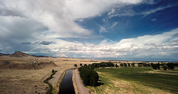
Across the southwest, water is an essential, often scarce resource that communities rely on for their ways of life. In south-central Colorado, the Rio Grande, its tributaries and the water flowing underground supports communities across the San Luis Valley, an 8,000 square-mile high elevation desert that sees less than seven inches of precipitation per year. Water ties generations of people and communities together across the Valley. Married by shared ethics of caring for land and water, everyone across the San Luis Valley depends deeply on the Rio Grande – for their livelihoods, the rich diversity of wildlife and outdoor activities, and a deep connection to the rich history of people who have come before them.
Rio Grande River, CO | Photo By Sinjin Eberle
To help tell the story of the San Luis Valley, the interdependent nature of the people, the river and water flowing below their feet and the threats facing the Valley’s way of life, American Rivers developed Groundswell on the Rio Grande, an interactive ESRI Story Map that illustrates the connection between people, communities and water.
In developing the Story Map, we had the pleasure of engaging with a wide cross-section of people that rely on and appreciate the Valley’s waters for different reasons. Whether we talked to a rancher, small business owner, recreation advocate, retired bus driver, brewer or water manager, it was clear how important the Valley, and the Valley’s water is to them. Water undeniably touches everyone in the Valley, but it is the threats to the rivers and aquifers that bring communities together to fight for their water.
San Luis People’s Ditch March 17, 2018. Photo credit: Greg Hobbs
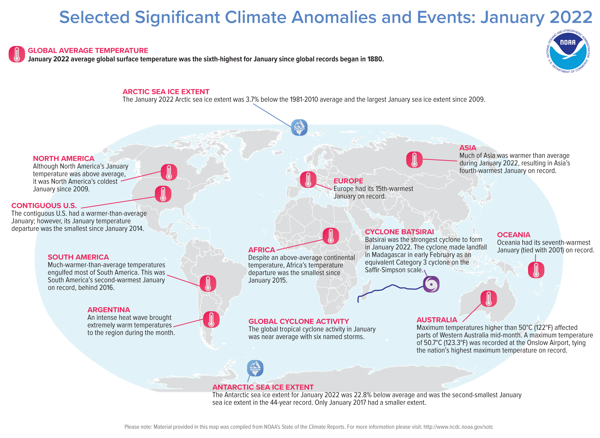
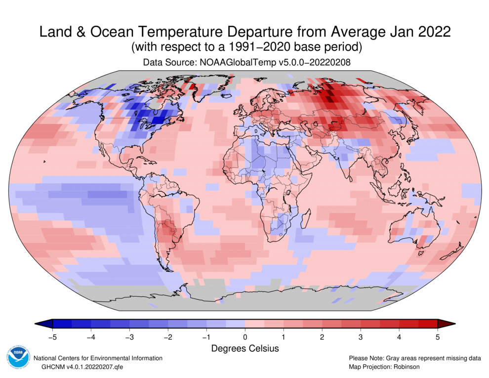
The global temperature for January 2022 was the sixth highest for January in the 143-year NOAA record, which dates back to 1880. According to NCEI’s Global Annual Temperature Rankings Outlook, it is virtually certain (> 99.0%) that the year 2022 will rank among the 10 warmest years on record.
This monthly summary, developed by scientists at NOAA’s National Centers for Environmental Information, is part of the suite of climate services NOAA provides to government, business, academia and the public to support informed decision-making.
Monthly Global Temperature
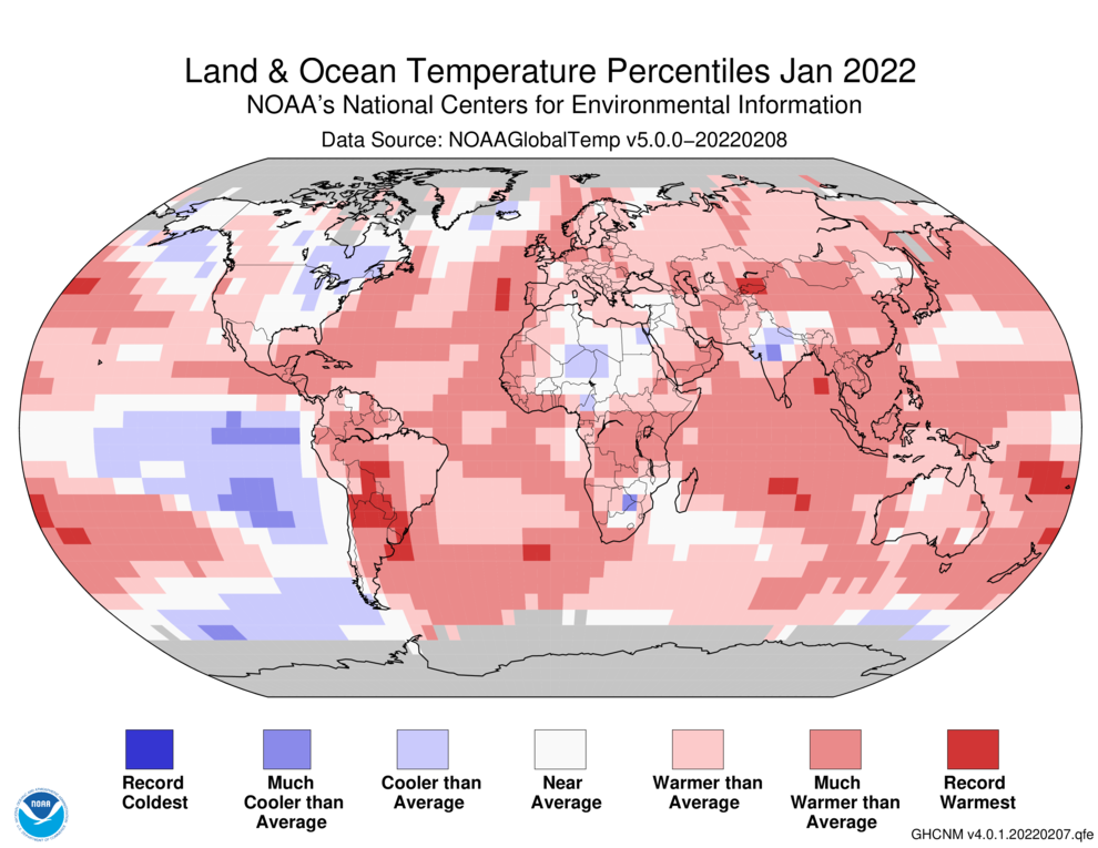
The January 2022 global surface temperature was 1.60°F (0.89°C) above the 20th-century average of 53.6°F (12.0°C) and ranked as the sixth-warmest January in the 143-year record. January 2022 also marked the 46th consecutive January and the 445th consecutive month with temperatures, at least nominally, above the 20th-century average.
Temperatures were much above average across most of South America, resulting in its second-warmest January on record. Only January of 2016 was warmer. Much of the Atlantic, northern Indian, and western Pacific oceans, as well as parts of southern North America, western and southern Africa, and southern Asia had much-above-average temperatures. Meanwhile, cooler-than-average temperatures were observed across parts of northern North America, northern Africa, India, and the Pacific Ocean.
Asia, as a whole, had its fourth-warmest January on record, while Oceania’s January temperature departure tied with 2001 as the seventh highest on record. Despite North America and Africa’s above-average January temperature, they had their coldest January since 2009 and 2015, respectively.
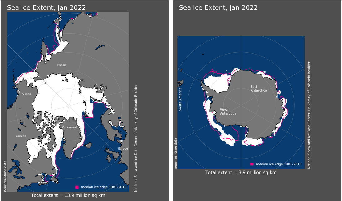
Sea Ice and Snow Cover
According to data from NOAA and analysis by the Rutgers Global Snow Lab, the Northern Hemisphere snow cover extent during January was slightly above the 1981-2010 average at 18.26 million square miles. This was the largest January snow cover extent since 2017. North America had near-average January snow cover extent, while Eurasia had slightly above-average January snow cover extent.
The January 2022 Arctic sea ice extent averaged 5.36 million square miles, which is 208,000 square miles below the 1981-2010 average. Although the monthly sea ice extent was below average for the month, it was the largest January extent since 2009. According to the National Snow and Ice Data Center (NSIDC), regional sea ice extent was below average in the Sea of Okhotsk, Barents Sea, and the Gulf of St. Lawrence, while the Bering Sea had above-average extent for the month.
The Antarctic sea ice extent for January 2022 was the second smallest January sea ice extent in the 44-year record at 1.49 million square miles, which is 440,000 square miles below average. Only January of 2017 had a smaller sea ice extent at 470,000 square miles below average.
Global Tropical Cyclones
Six tropical storms formed globally in January, which is near normal. However, most of them were weak, so the accumulated cyclone energy (ACE: an integrated metric of the strength, frequency, and duration of tropical storms) was the third lowest since 1981. The Northern Hemisphere had no tropical cyclone activity during January 2022, which is not unusual. In the Southern Hemisphere, the strongest cyclone that formed during the month was Major Cyclone Batsirai, which made landfall in Madagascar in early February as an equivalent Category 3 cyclone on the Saffir-Simpson scale.
Ranking and time evolution of summer (June–August) drought severity as indicated by negative 0–200 cm soil moisture anomalies. Maps show how gridded summer drought severity in each year from 2000–2021 ranked among all years 1901–2021, where low (brown) means low soil moisture and therefore high drought severity. Yellow boxes bound the southwestern North America (SWNA) study region. Time series shows standardized anomalies (σ) of the SWNA regionally averaged soil moisture record relative to a 1950–1999 baseline. Black time series shows annual values and the red time series shows the 22-year running mean, with values displayed on the final year of each 22-year window. Geographic boundaries in maps were accessed through Matlab 2020a.
Click the link to access the paper at Nature Climate Change (A. Park Williams, Benjamin I. Cook & Jason E. Smerdon). Here’s the abstract:
A previous reconstruction back to 800 CE indicated that the 2000–2018 soil moisture deficit in southwestern North America was exceeded during one megadrought in the late-1500s. Here, we show that after exceptional drought severity in 2021, ~19% of which is attributable to anthropogenic climate trends, 2000–2021 was the driest 22-yr period since at least 800. This drought will very likely persist through 2022, matching the duration of the late-1500s megadrought.
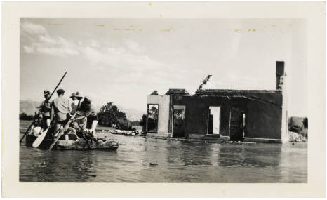
Salvage crew at St. Thomas, Nevada during Lake Mead first fill, 1938 via University of Nevada Las Vegas
Click the link to view an article on The Los Angeles Times (Ian James). Here’s an excerpt:
In their research, the scientists examined major droughts in southwestern North America back to the year 800 and determined that the region’s desiccation so far this century has surpassed the severity of a megadrought in the late 1500s, making it the driest 22-year stretch on record. The authors of the study also concluded that dry conditions will likely continue through this year and, judging from the past, may persist for years.
The researchers found the current drought wouldn’t be nearly as severe without global warming. They estimated that 42% of the drought’s severity is attributable to higher temperatures caused by greenhouse gases accumulating in the atmosphere…
Williams and his colleagues compared the current drought to seven other megadroughts between the 800s and 1500s that lasted between 23 years and 30 years.
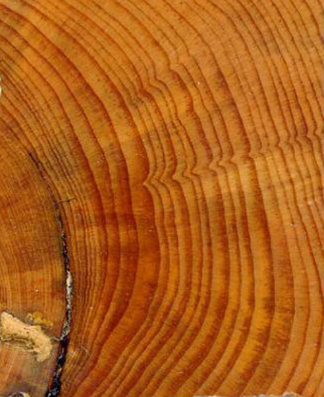
Concentric rings of various widths mark the annual growth of trees. Photo by Peter Brown, Rocky Mountain Tree-Ring Research. Photo credit: NOAA
They used ancient records of these droughts captured in the growth rings of trees.
Wood cores extracted from thousands of trees enabled the scientists to reconstruct the soil moisture centuries ago. They used data from trees at about 1,600 sites across the region, from Montana to California to northern Mexico…
Some scientists describe the trend in the West as “aridification” and say the region must prepare for the drying to continue as temperatures continue to climb.
Brad Udall: Here’s the latest version of my 4-Panel plot thru Water Year (Oct-Sep) of 2021 of the Colorado River big reservoirs, natural flows, precipitation, and temperature. Data (PRISM) goes back or 1906 (or 1935 for reservoirs.) This updates previous work with @GreatLakesPeck.
Click the link to read an article from The New York Times (Henry Fountain). Here’s an excerpt:
But exceptional conditions in the summer of 2021, when about two-thirds of the West was in extreme drought, “really pushed it over the top,” said A. Park Williams, a climate scientist at the University of California, Los Angeles, who led an analysis using tree ring data to gauge drought. As a result, 2000-21 is the driest 22-year period since 800 A.D., which is as far back as the data goes…
Julie Cole, a climate scientist at the University of Michigan who was not involved in the research, said that while the findings were not surprising, “the study just makes clear how unusual the current conditions are.”
Dr. Cole said the study also confirms the role of temperature, more than precipitation, in driving exceptional droughts. Precipitation amounts can go up and down over time and can vary regionally, she said. But as human activities continue to pump greenhouse gases into the atmosphere, temperatures are more generally rising.
As they do “the air is basically more capable of pulling the water out of the soil, out of vegetation, out of crops, out of forests,” Dr. Cole said. “And it makes for drought conditions to be much more extreme.”
[…]
Although there is no uniform definition, a megadrought is generally considered to be one that is both severe and long, on the order of several decades. But even in a megadrought there can be periods when wet conditions prevail. It’s just that there are not enough consecutive wet years to end the drought.
That has been the case in the current Western drought, during which there have been several wet years, most notably 2005…
Several previous megadroughts in the 1,200-year record lasted as long as 30 years, according to the researchers. Their analysis concluded that it is likely that the current drought will last that long. If it does, Dr. Williams said, it is almost certain that it will be drier than any previous 30-year period…
Monsoon rains in the desert Southwest last summer had offered hope that the drought might come to an end, as did heavy rain and snow in California from the fall into December.
But January produced record-dry conditions across much of the West, Dr. Williams said, and so far February has been dry as well. Reservoirs that a few months ago were at above-normal levels for the time of year are now below normal again, and mountain snowpack is also suffering. Seasonal forecasts also suggest the dryness will continue.
Lake Powell boat ramp at Page, Arizona, December 17, 2021. Photo credit: Allen Best/Big Pivots
Click the link to read an article on National Public Radio (Nathan Rott). Here’s an excerpt:
Today, the region is home to tens of millions of people, massive agricultural centers and some of the fastest-growing cities in the U.S. — all in an area where there’s less water available than there was in the past, partially due to human-caused climate change.
“We have a society that’s relying on there being the amount of water there was in the 1900s,” said the study’s lead author, Park Williams, a bioclimatologist at the University of California, Los Angeles. “But now with the number of water molecules available to us declining, it really is time for us to get real about how much water there is for us to use.”
[…]
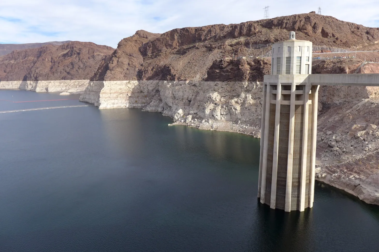
Lake Mead and Lake Powell, the country’s two largest reservoirs, are filled at only about one-third of their total capacity. Communities, ranchers and farmers have depleted groundwater stores to meet demands…
Existing management guidelines for the Colorado River are set to expire in 2026. The seven states that draw from the watershed are negotiating with the federal government, Native American tribes and Mexico over what future management should look like.
Last December, Nevada, Arizona and California agreed to take less water from the Colorado River in an effort to prop up Lake Mead, and more cuts could follow…
“We actually have to change our relationship with water,” [Park Williams said.]
This photo from December 2021 shows one of the intake towers at Hoover Dam. California, Nevada and Arizona recently penned a deal to keep 500,000 acre-feet of water in Lake Mead to boost the declining reservoir levels. CREDIT: HEATHER SACKETT/ASPEN JOURNALISM
Click the link to read an article on The Pueblo Chieftain (Seth Borenstein). Here’s an excerpt:
A dramatic drying in 2021 – about as dry as 2002 and one of the driest years ever recorded for the region – pushed the 22-year drought passed the previous record-holder for megadroughts in the late 1500s and shows no signs of easing in the near future, according to a study Monday in the journal Nature Climate Change…
Williams studied soil moisture levels in the West – a box that includes California, Wyoming, Utah, Nevada, Arizona, most of Oregon and Idaho, much of New Mexico, western Colorado, northern Mexico, and the southwest corners Montana and Texas – using modern measurements and tree rings for estimates that go back to the year 800. That’s about as far back as estimates can reliably go with tree rings…
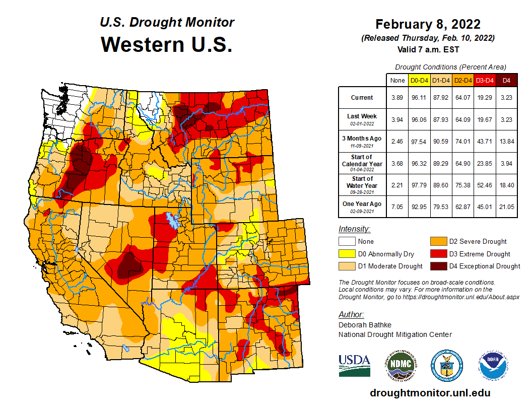
West Drought Monitor map February 8, 2022.
The drought monitor says 55% of the U.S. West is in drought with 13% experiencing the two highest drought levels…
Climate change from the burning of fossil fuels is bringing hotter temperatures and increasing evaporation in the air, scientists say.
Williams used 29 models to create a hypothetical world with no humancaused warming then compared it to what happened in real life – the scientifically accepted way to check if an extreme weather event is due to climate change. He found that 42% of the drought conditions are directly from human-caused warming. Without climate change, he said, the megadrought would have ended early on because 2005 and 2006 would have been wet enough to break it.
The study “is an important wakeup call,” said Jonathan Overpeck, dean of environment at the University of Michigan, who wasn’t part of the study. “Climate change is literally baking the water supply and forests of the Southwest, and it could get a whole lot worse if we don’t halt climate change soon.”
Williams said there is a direct link between drought and heat and the increased wildfires that have been devastating the West for years. Fires need dry fuel that drought and heat promote.
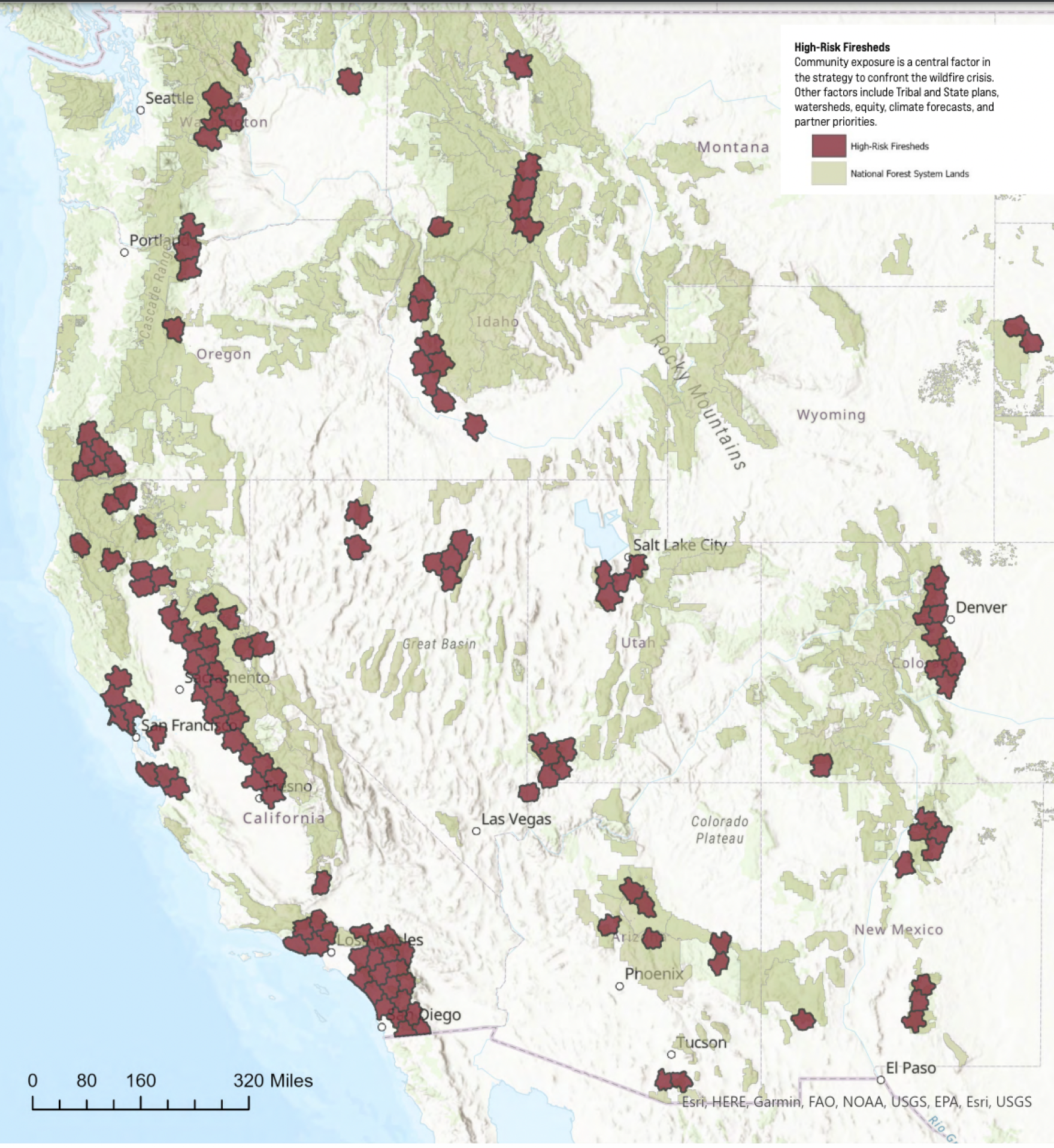
USFS highest risk firesheds January 2022.
Click the link to read an an article from The Washington Post (Diana Leonard). Here’s an excerpt:
The extreme heat and dry conditions of the past few years pushed what was already an epic, decades-long drought in the American West into a historic disaster that bears the unmistakable fingerprints of climate change. The long-running drought, which has persisted since 2000, can now be considered the driest 22-year period of the past 1,200 years, according to a study published Monday in the journal Nature Climate Change…
The double whammy of searing heat and persistent drought in recent years reflects the steady increase in global temperatures brought on by the burning of fossil fuels. The authors attribute 19 percent of the severe 2021 drought, and 42 percent of the extended drought since the 21st century began, to human-caused climate change…
This “background drying” brought on by a warmer atmosphere can dwarf occasional wet or cool periods. For example, the Southwest’s 2021 drought maintained its grip despite robust monsoon rains and record summer precipitation in some areas, in part because of extraordinary heat waves early last summer, and generally above-average temperatures…
The study finds that the 21st century has been substantially drier than the previous five decades, with 8.3 percent less precipitation, and nearly 1 degree Celsius (1.8 Fahrenheit) warmer than the period from 1950 to 1999…
That analysis found that at the current warming trajectory, droughts in drying regions that previously occurred only once every 10 years are now happening about 1.7 times per decade, on average. If the Earth warms 2 degrees Celsius, scientists expect those once-rare events to take place roughly 2½ times per decade, on average…
From Wednesday through Sunday, the National Weather Service in Los Angeles issued the first heat advisory on record during the winter months in Southern California. Scores of record high temperatures were set, from San Diego to San Francisco.
Death Valley soared to 94 degrees on Feb. 11, its highest temperature recorded so early in the season.
Douglas Fir tree rings via the Western Water Assessment
Click the link to read an article on The Guardian (Gabrielle Canon):
Turning up the temperature – the result of human caused warming – has played a big part. Other studies show how the climate crisis “will increasingly enhance the odds of long, widespread and severe megadroughts”, the researchers write. Noting that as the west is now in the midst of the driest 22-year period in knowable history, “this worst-case scenario already appears to be coming to pass”.
The research builds on conclusions from a previous study, also led by Williams, that ranked the period between 2000 and 2018 as the second driest in 12 centuries. The last two incredibly dry years – which were marked by record-setting heatwaves, receding reservoirs, and a rise in dangerously erratic blazes that burned both uncontrollably and unseasonably – were enough to push this period into first…
Looking at moisture levels in soils, the team of climate scientists from UCLA, Nasa, and Columbia University focused on landscapes from Montana to northern Mexico north to south and from the Pacific Ocean to the Rocky Mountains. They analyzed data collected tree ring patterns that offered clues to soil moisture levels throughout the centuries. Rings that appear closer together show the stunted growth patterns occurring during dry times…
According to Jason Smerdon, a climate scientist at the Lamont-Doherty Earth Observatory of Columbia University who worked with Williams on the study, the crisis is a “slow-motion trainwreck”.
“These multi-decade periods of dryness will only increase with the rest of the century,” Smerdon said.
Still, Smerdon cast the conclusions in a more hopeful light. The extreme events taking place right in people’s backyards may spur understanding and action. “Knowing is half the battle,” he says. “We have a lot of challenges in front of us but we all have agency in the face of this. And there are pathways we can take that are much more sustainable and involve much less risk than the burn baby burn approach that we would take if we didn’t do anything.”
The bill creates the groundwater compact compliance and sustainability fund to help finance groundwater use reduction efforts in the Rio Grande River Basin and the Republican River Basin, including buying and retiring irrigation wells and irrigated acreage.
The Colorado Water Conservation Board administers the fund and can make expenditures based on recommendations from the board of directors of the Rio Grande Water Conservation District or the Republican River Water Conservation District. A conservation district’s recommendations must first be approved by the state engineer…
Clearly referencing the water development investment group Renewable Water Resources (RWR), Donovan wanted to know how to explain a group of people wanting to export water from the valley when it is clear water scarcity is already an issue. Robbins, who was testifying at the time, responded that it was something they “were trying to understand themselves” but said that the Rio Grande Water Conservation District is united in their resolve to fight the efforts with all they have.
Referencing the RWR proposal, Donovan then commented that being given money to build a senior citizen center or for law enforcement won’t help much if there are no senior citizens or communities left. She then commented that the General Assembly is receiving the message that the group “needs to look for water somewhere else.”