The Western U.S. 2022 winter has been a bit manic so far, swinging from a snow-sad October and November to jubilant late December storms that cranked snowpack levels from about 30 percent of normal to 150 percent of normal over a few weeks’ time. And then it just stopped. A relentless blue sky has hovered over most of the region for weeks. The high altitude sun has baked south-facing slopes daily and plummeting nighttime temperatures freeze it solid, setting the stage for a nasty avalanche cycle when—or if—big February snows arrive.
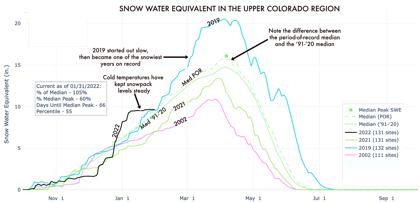
This has left the snowpack levels across the Upper Colorado River Basin close to average for this time of year. Levels are healthier to the north—the North Fork of the Gunnison is sitting at 125 percent of median—and thinner in southern zones such as the Rio Grande Headwaters, which are only at 86 percent of normal. While ski slopes are icy, the snow generally is holding up for skiing and nordic (and kick-sledding) conditions are super fast. Folks in the snow-removal business, however, are hating it, and water managers are on edge once again.
This graph shows not only the manic nature of this year’s snowfall, but also illustrates the decline in median snowpack over time, seen by comparing the period-of-record (POR) median with the median level over the last two decades. Source: USDA NRCS via The Land Desk
To prepare for what thus-far promises to be a mediocre spring runoff, federal Bureau of Reclamation officials are getting ready to implement a drought response plan which will kick in when (not if) Lake Powell’s surface level drops below 3,525 feet above sea level. It is currently sitting at 3,531 feet, 45 feet lower than a year ago. Officials have already nearly drained upstream reservoirs and then decreased release flows from Glen Canyon Dam in hopes of keeping levels above the minimum needed to produce hydropower. Yet the decline continues nevertheless: The Reservoir has lost 371,840 acre feet (12 billion gallons) of water in the last month.
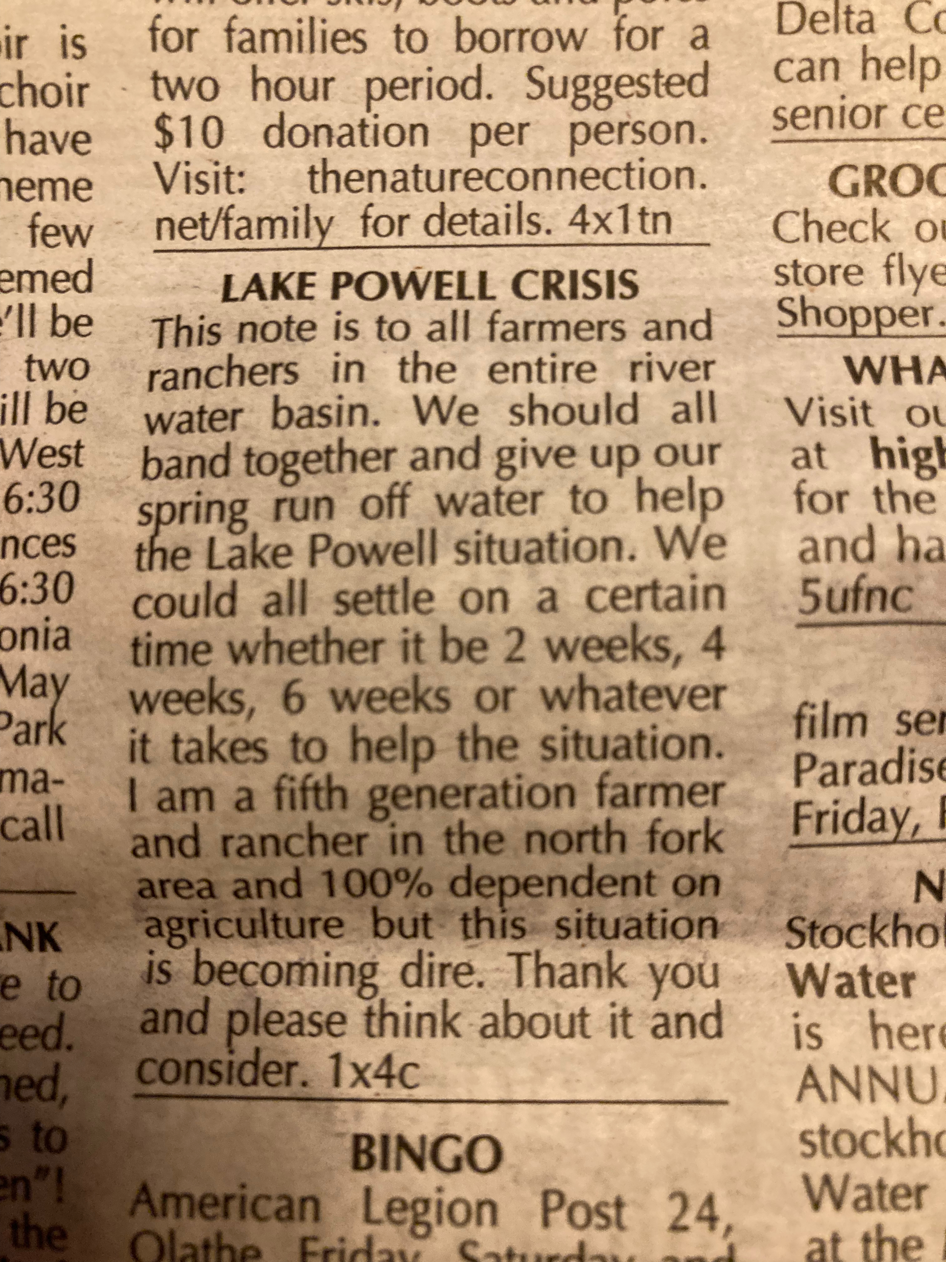
Maybe if a bunch of upstream farmers got together and stopped irrigating for a few weeks this summer they could solve Powell’s Problem? That seems to be what this advertisement I stumbled across in the High Country Shopper out of Delta County, Colorado, is proposing:
It is for content like this that I religiously read the High Country Shopper whenever I’m in Delta County. Photo credit: Jonathan Thompson/The Land Desk
If you know about Western water and the feelings it inspires, then you’ll realize how magnanimous this offer really is. No one in the arid West wants to give up their water. Ever. Which is why it’s highly unlikely that this person can convince enough farmers to shut off their ditches for long enough to make a difference. And you also have to wonder what they’re trying to save. Do they hope to bolster lake levels enough to get the boat ramps back open? Or do they simply want to preserve hydropower generating capacity for as long as possible?
Whatever the case, I’d encourage them to go forward with the plan. It may not mean much to Lake Powell, but a bit of extra water in the rivers sure would be nice for downstream boaters and fish.
Here’s the release from the Department of Interior:
The Department of the Interior today announced $1.15 billion in funding is available to states from the Bipartisan Infrastructure Law to create jobs cleaning up orphaned oil and gas wells across the country. This is a key initiative of President Biden’s Bipartisan Infrastructure Law, which allocated a total of $4.7 billion to create a new federal program to address orphan wells. Millions of Americans across the country live within a mile of an orphaned oil and gas well.
Orphaned wells are polluting backyards, recreation areas, and public spaces across the country. The historic investments to clean up these hazardous sites will create good-paying, union jobs, catalyze economic growth and revitalization, and reduce dangerous methane leaks.
“President Biden’s Bipartisan Infrastructure Law is enabling us to confront the legacy pollution and long-standing environmental injustices that for too long have plagued underrepresented communities,” said Secretary Deb Haaland. “We must act with urgency to address the more than one hundred thousand documented orphaned wells across the country and leave no community behind. This is good for our climate, for the health of our communities, and for American workers.”
Plugging orphaned wells will also help advance the goals of the U.S. Methane Emissions Reduction Action Plan, as well as the Interagency Working Group on Coal and Power Plant Communities and Economic Revitalization, which focuses on spurring economic revitalization in the hard-hit energy communities.
Nearly every state with documented orphaned wells submitted a Notice of Intent (NOI) indicating interest in applying for a formula grant to fund the proper closure and cleanup of orphaned wells and well sites.
The Department today released the amount of funding that states are eligible to apply for in Phase One, which includes up to $25 million in Initial Grant funding and a quarter of the total Formula Grant money available for the 26 states that submitted NOIs. These allocations were determined using the data provided by states from the NOIs and equally considers the following factors required by the Bipartisan Infrastructure Law: job losses in each state from March 2020 through November 2021; the number of documented orphaned oil and gas wells in each state; and the estimated cost of cleaning up orphaned wells in each state.
“The Department is taking a thoughtful and methodical approach to implementing the orphaned oil and gas well program that aims to get money to states as quickly as possible while being responsible stewards of taxpayer dollars. We are committed to ensuring states receive investments equitably and based on data-driven needs,” added Secretary Haaland.
In the coming weeks, the Department will release detailed guidance for states to apply for the Initial Grants. These resources will allow state officials to begin building out their plugging programs, remediating high-priority wells, and collecting additional data regarding the number of orphaned wells in their states. Improvements in the state data, combined with more accurate Bureau of Labor Statistics job loss data that will be released in upcoming months, will allow the Department to ensure that the final formula funding for states is based on the best information available.
Application guidance will also be released in the coming months for states to access the Formula Grant funding they are eligible for, followed by further instructions to apply for the $1.5 billion in state Performance Grants, the third type of state grant program set up in the Bipartisan Infrastructure Law. The Tribal orphaned well grant program, a $150 million component of the broader orphaned well program, is being informed by ongoing Tribal consultations and listening sessions. The law also provides for a separate $250 million program for remediation of orphan wells on federal land, which will be implemented through Interior’s Bureau of Land Management.
Yellowstone Caldera Chronicles is a weekly column written by scientists and collaborators of the Yellowstone Volcano Observatory. This week’s contribution is from Michael Poland, geophysicist with the U.S. Geological Survey and Scientist-in-Charge of the Yellowstone Volcano Observatory.
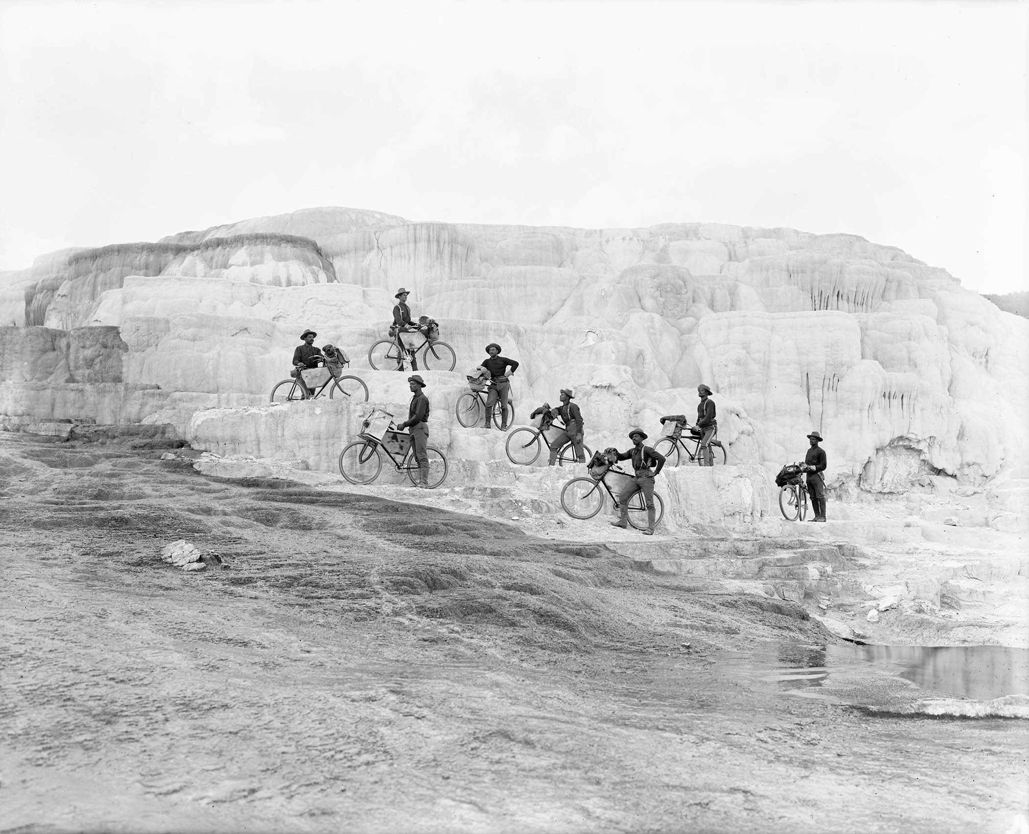
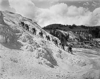
The Buffalo Soldiers of the 25th Infantry Regiment Bicycle Corps pose on Minerva Terrace, Mammoth Hot Springs, Yellowstone National Park. Pvt. John Findley, front left, was the primary bicycle mechanic for the unit, and so carried a heavy toolbox attached to his handlebars. Photo by F. Jay Haynes, 1896. Montana Historical Society Research Center, Haynes Foundation Photograph Collection, H-3614. Used with permission from the Montana Historical Society.
Bicycles as a means of military transport in the U.S. Army was suggested by Lt. James Moss, an officer in the 25th Infantry, following the example of some European armies. Bicycles offered several advantages over horses—they didn’t require food or water, didn’t make as much noise, and could be repaired if they broke down. His proposal to test the concept was approved by Army leadership, so Lt. Moss began training volunteers from the 25th Infantry Regiment.
The Buffalo Soldiers of the 25th Infantry Regiment Bicycle Corps walk their cycles up Minerva Terrace, Mammoth Hot Springs, Yellowstone National Park. Photo by F. Jay Haynes, 1896. Montana Historical Society Research Center, Haynes Foundation Photograph Collection, H-3615. Used with permission from the Montana Historical Society.
The Bicycle Corps pedaled into action for the first time in early August 1896, starting with a four-day, 126-mile ride in the vicinity of Missoula, Montana. This might not sound spectacular, given that Ironman Triathlon bicycle legs cover about the same distance, but remember, this was 1896. The roads were not paved, and the one-speed bicycles, custom built by A.G. Spalding & Co. of Chicopee Falls, Massachusetts, each weighted over 30 pounds. Importantly, unlike the Ironman, the soldiers also had to carry food, utensils, weapons, ammunition, clothes, repair parts and tools, bedrolls, and tents—well over 100 pounds all told!
After a few days of rest, the Bicycle Corps began their next expedition on August 15—to Yellowstone National Park and Fort Yellowstone, a journey of over 300 miles that took just over 8 days.
After 2 days of rest and reprovisioning at Fort Yellowstone, the Corps set out on a tour of the Park on August 25, stopping at Lower Geyser Basin, Upper Geyser Basin (where they observed Old Faithful, Giantess, and Castle Geysers all erupting at the same time), West Thumb, and the Grand Canyon of the Yellowstone and its waterfalls, returning to Mammoth Hot Springs on August 29. After 2 additional days of rest, during which the iconic photo and several others were taken, the soldiers headed back to Fort Missoula, riding in on September 8—a total journey of nearly 800 miles.
As part of his official report, Lt. Moss recorded that the trip through Yellowstone included 132 miles completed in 19 hours of actual bicycling. The slowest pace was between Upper Geyser Basin and West Thumb, when the soldiers had to cross the Continental Divide—twice! The fastest time was between Fort Yellowstone and Norris Geyser Basin.
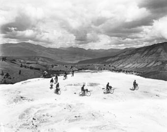
The Buffalo Soldiers of the 25th Infantry Regiment Bicycle Corps ride on an inactive portion of Minerva Terrace, Mammoth Hot Springs, Yellowstone National Park. Photo by F. Jay Haynes, 1896. Montana Historical Society Research Center, Haynes Foundation Photograph Collection, H-3616. Used with permission from the Montana Historical Society.Ft. Missoula, Montana. Yellowstone National Park.” 25th Infantry. October 7, 1896 [August 1896 per Moss’s diary]
Although there are no records of what the soldiers themselves thought, Lt. Moss recorded that “The soldiers were delighted with the trip…thought the sights grand…and seemed to be in the best of spirits the whole time.” Moss also remarked on “the moral effect of the seething water, the roaring of the geysers and the sulphuric fumes.”
Even the Yellowstone journey was just a warmup. In 1897, Moss organized 20 soldiers of the 25th Infantry on a 40-day, 1,900-mile ride from Fort Missoula to St. Louis. A planned ride to San Francisco the following year was canceled owing to the outbreak of the Spanish-American War, and the 25th Infantry was deployed to the Philippines.
Although never based in Yellowstone National Park, Buffalo Soldiers had a profound and lasting impact on the early national parks. Serving under perhaps the first Black officer, Charles Young, they were rangers and interpreters in places like Yosemite and Sequoia National Parks, helping tourists and even blazing trails—for example, to the summit of Mount Whitney.
The next time you drive—or cycle!—around Yellowstone National Park, think of the challenging conditions that faced the intrepid Buffalo Soldier bicyclists of the 25th Infantry Regiment, who completed a tour of the park after riding from Missoula and carrying their own provisions, spare parts, and equipment. And the challenges were not purely physical and logistical—of course, they also faced discrimination and were paid less than their white counterparts. But wherever they went, the men of the 25th distinguished themselves, with one Montana newspaper editor remarking, “The prejudice against the…soldiers seems to be without foundation for if the 25th Infantry is an example of the [Black] regiments there is no exaggeration in the statement that there are no better troops in the service.”
The 8 cyclists of the Yellowstone expedition were Sgt. Dalbert P. Green, Cpl. John G. Williams, Pvt. John Findley, Pvt. Frank L. Johnson, Pvt. William Proctor, Pvt. William Haynes, Pvt. Elwood Forman, and Musician William W. Brown.
For more information on the exploits of the 25th Infantry Regiment Bicycle Corps, see:
[1] Following the Civil War, Congress passed legislation to reorganize the military and included these regiments of Afro-Americans, many of whom were among the approximately 180,000 African Americans who previously served in the Union Army. From 1867 to the early 1890s, these regiments served at a variety of posts in the southwestern United States and the Great Plains regions. It was from one of these regiments, the 10th Cavalry, that the nickname Buffalo Soldier was born. Indigenous tribes of the American plains who fought against these soldiers allegedly referred to the black cavalry troops as “buffalo soldiers” because of their dark, curly hair, which resembled a bison’s coat, and because of their fierce nature of fighting. The nickname soon became synonymous with all African-American regiments formed in 1866.
A view of public lands around the Sangre de Cristo Mountains and just south from the area Renewable Water Resources has proposed a wellfield for water exportation. Photo credit: Alamosa Citizen
CALLING it a “carefully crafted plan,” former Colorado Gov. Bill Owens defended efforts by Renewable Water Resources to export water from the San Luis Valley in a pointed opinion published Sunday.
Owens is leading the RWR plan and called out “status-quo politicians who are stoking fear doubling down on one valid reality: the San Luis Valley is one of the most economically challenged areas of our state.”
“When the attorney general and state Sen. Cleave Simpson claim they will do all they can to stop the voluntary selling of water rights, they are saying to Coloradans that they know better than you do what to do with your private property,” Owens penned in the op/ed published in ColoradoPolitics.com.
Simpson responded during Monday’s Douglas County commissioners work session on the RWR plan. Douglas County is vetting the proposal for a $20 million investment, using its federal COVID relief money to potentially buy into the RWR plan and pump groundwater in perpetuity to Douglas County from the Valley.
“Myself and the Rio Grande Water Conservation District very intentionally have not tried to implement any type of rule or legislation that would interfere with private property rights,” Simpson said. “If folks are interested in selling water rights to Renewable Water Resources we’ve not stood in the way. We certainly would challenge that a change in the water right and the proposal as crafted isn’t good for the community, and likely our position would be ‘I’m not sure you can do it without injuring other water rights.’”
Simpson was joined by other Valley water managers who briefed Douglas County commissioners on the most current groundwater withdrawals and condition of the unconfined and confined aquifers in the Upper Rio Grande Basin. The RWR groundwater pumping and exportation plan draws from the confined aquifer in Saguache County and is in a part of the Rio Grande Basin considered not sustainable due to current withdrawals.
Owens, making a point in his opinion piece that there is water in the San Luis Valley available for exportation, said “the San Luis Valley pumps over 600,000 acre-feet of water from the aquifers every year.” Actual water flow meter readings show Valley farmers pumped 458,000 acre-feet in 2020, according to data presented to Douglas County commissioners.
The commissioners also saw figures that show the Rio Grande with an average flow of 550,000 acre-feet over the past 20 years, down 15 percent from the Rio Grande’s historical average going back to 1890 when water flows on the Rio Grande started to be measured.
“We’re not guessing at the numbers that we pump. We’re not guessing at the amount of water we’re withdrawing, and we’re not guessing at what it takes to farm in the San Luis Valley,” said Conejos County farmer Nathan Coombs. He is on the board of the Rio Grande Water Conservation District’s Subdistrict 3.
San Luis garden. Photo credit: The Alamosa Citizen
“We don’t have different points of view on the same subject, we have different interests on the same subject,” Coombs said. “The San Luis Valley, we’re needing just to survive in our agriculture economy and with our neighbors. The Renewable Water proposal is just about money. It’s about an exportation of a cash commodity.
“We are struggling to keep our ship correct and to try to recover our aquifer, and then here comes this seemingly predatory-natured entity to exacerbate our problem when we’re in the middle of a hardship.”
Coombs showed Douglas County commissioners where he farms in Conejos County and how it’s 53 miles away from Renewable Water Resources’ proposed wellfield. He said it’s incomprehensible to think the RWR groundwater pumping and exportation of water to Douglas County wouldn’t impact his operations and farming operations in the Valley as a whole.
Denver Basin Aquifer System graphic credit USGS.
“Those of us who have voluntarily worked our tails off to become sustainable, it’s a slap in the face. Who am I? I’m expendable? Denver Basin aquifer should be sustained, San Luis Valley should not? We should import water so unsustained growth on the Front Range continues to expand, where I have to limit the size of my operation because I have to live within my means?
“Why are we trading one aquifer for the other? I think we all matter don’t we? Why can’t agriculture interests in the San Luis Valley matter as much as the Denver aquifer?”
For Owens, the former governor of Colorado, it’s a “false assertion that there is ‘no water’ available in the SLV.”
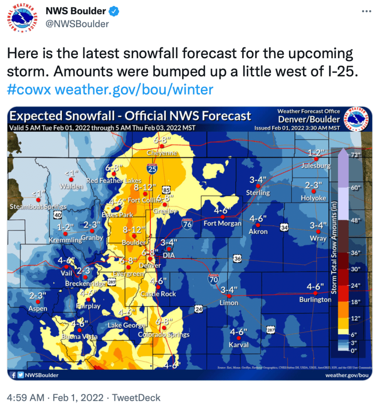
FromThe Fort Collins Coloradoan (Miles Blumhardt):
NWS issued a winter weather advisory for 5 p.m. Tuesday to late Wednesday night for a large swath of the northern mountains, foothills, I-25 corridor and stretching onto the Eastern Plains…
The slow-moving storm will mostly center on the foothills, Interstate 25 corridor and Eastern Plains, according to the National Weather Service.
Snow will first develop over the mountains and foothills Tuesday afternoon and spread east across the I-25 corridor in the late afternoon and early evening. It’ll be onto the Eastern Plains by Tuesday night.
Snow will continue throughout Wednesday, leaving behind bitter cold…
The higher snow totals are expected in the foothills and just west of I-25.
The forecast calls for an 80% chance of snow Tuesday night and 90% during the day on Wednesday in Fort Collins, resulting in 6 to 8 inches of snow…
Cheyenne, Boulder, Estes Park and Red Feather Lakes could see similar snowfall as Fort Collins, while Greeley, Denver and most of the Eastern Plains are forecast to see 4 to 6 inches…
[Fort Collins] has had 19.1 inches of snow this season, compared with the average of 26.6 inches, according to the Colorado Climate Center.
At the end of January last year, the city had 33.4 inches of snow, on its way to 80 inches for the season, which is nearly 30 inches above average.
The city has had 11.9 inches of snow this January, compared with the average of 6.5 inches. The city would have had more, but most of the New Year’s Eve snowfall total went into December because the Colorado State University campus weather station records that day’s totals only through 7 p.m.
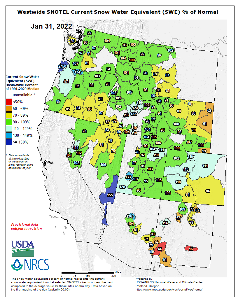
The statewide snowpack is at 104% of median, including 114% in the South Platte Basin in which Fort Collins is located, according to the National Resources Conservation Service.
Westwide SNOTEL basin-filled map January 31, 2022 via the NRCS.