Click on a thumbnail graphic to view a gallery of drought data from the US Drought monitor.
US Drought Monitor map February 8, 2022.
High Plains Drought Monitor map February 8, 2022.
West Drought Monitor map February 8, 2022.
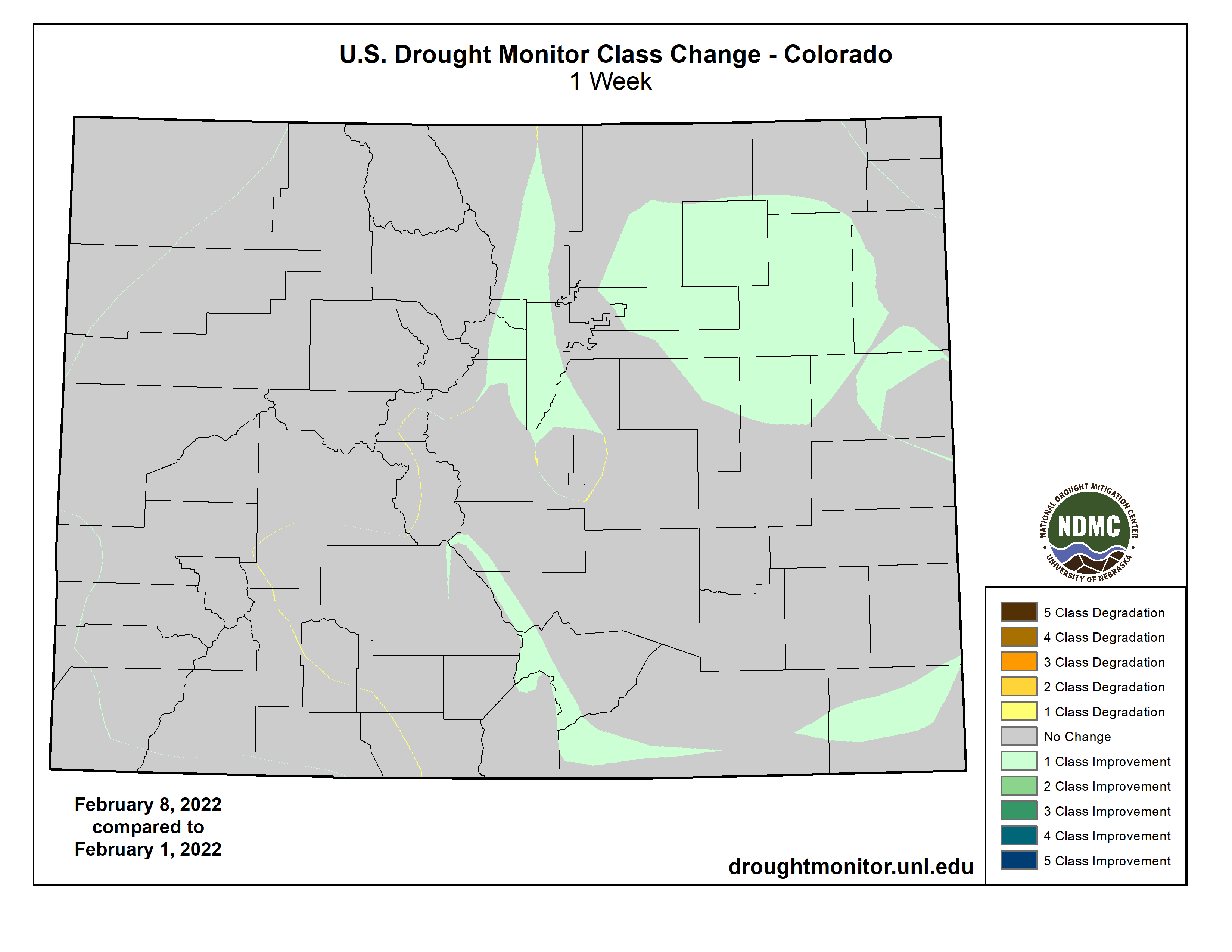
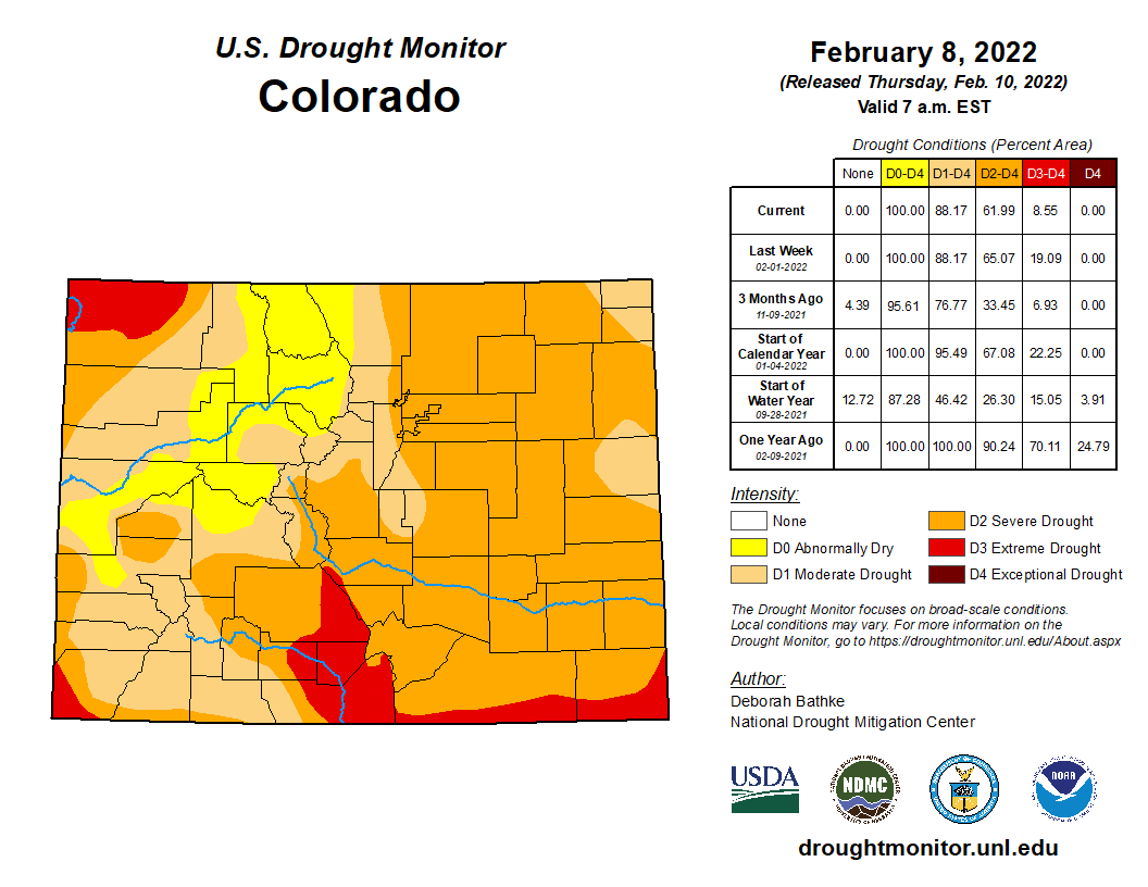
Colorado Drought Monitor map February 8, 2022.
Click here to go to the US Drought Monitor website. Here’s an excerpt:
This Week’s Drought Summary
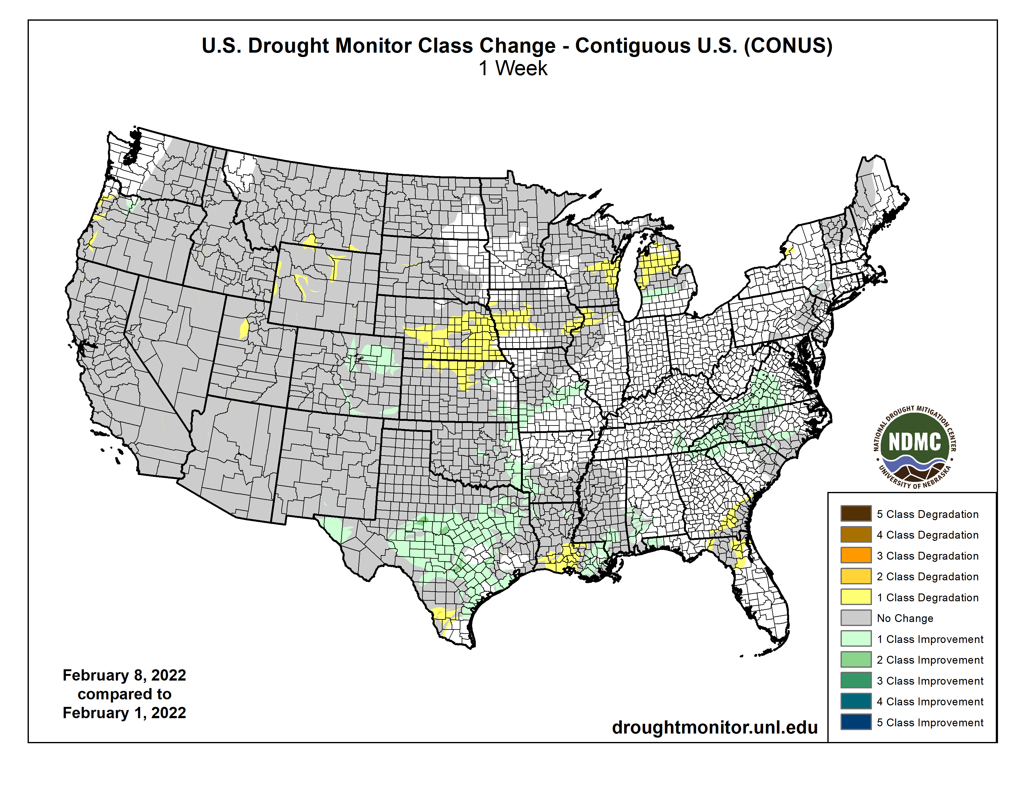
A powerful winter storm last week, stretching from New Mexico to Maine, helped improve drought conditions in 17 states in its path. Meanwhile, another week of dry weather in the West put a halt to drought recovery. Parts of Montana, Wyoming, Utah, and Oregon saw drought expand as the recent dryness on top of long-term drought chipped away at snowpack and lowered streamflow. A wet December left most other parts at near normal for the season, but concerns are growing as dry weather remains in the forecast…
Last week’s snow brought widespread improvements to eastern Colorado including areas of severe (D3) and extreme drought (D3). The recent event, combined with above average January snowfall, has left a large swath of snow on the ground and improved soil moisture conditions. The remainder of the region saw another week of dry weather. Wyoming saw an expansion of D2 and D3 in the north and west parts of the state as recent warm, dry weather, chipped away at seasonal snowpack. Nebraska and Kansas saw a broad expansion of moderate drought (D1) and abnormal dryness (D0). Here, 30-to-90-day precipitation totals rank in the top 5 driest on record. Fires on the rise in these areas and burn bans are going to effect…
Colorado Drought Monitor one week change map ending February 2, 2022.
Weather across the West was once again dry this week. Western Oregon saw expansions to moderate (D1) and severe (D2) drought increased. Another week of dry weather increased water-year-to-date precipitation shortfalls and lowered streamflow values. The far northern Oregon Cascades saw improvement. Snowpack here is near normal for the water year. Extreme drought (D3) was expanded in Utah as increasing precipitation deficits have dried out soils and lowered streamflow. The rest of the West remains unchanged. Several weeks of dry weather has caused high elevation snowpack in parts of the west to drift away from the above-normal values at the start of the new year…
Much needed rain brought by last week’s winter storm improved drought conditions in parts of all six states in the region. Precipitation totals of around 1 to 4 inches – more than 300% of normal in some areas – fell across much of the region helping to reduce short-term rainfall deficits and improve streamflow and soil moisture conditions. Texas saw a wide band of 1-category, with isolated 2-category, improvements. In parts of South and West Texas, the excess moisture was enough to chip away at the long-term drought. Other areas seeing improvements include eastern Kansas, eastern Oklahoma, southeastern Louisiana, and southern Mississippi. Widespread drought remains in the region. Despite last week’s weather, parts of Texas and Louisiana saw expansions of drought. These areas missed out on the heaviest rain, increasing moisture deficits. In South Texas rainfall deficits are approaching 5 to 6 inches (less than 50% of normal) over the last 3 months. In southwest Louisiana, they are about 7 to 10 inches (less than 50 % of normal) over the same time frame, reducing streamflow and drying soils…
Looking Ahead
The National Weather Service Weather Prediction Center forecast (valid February 10 – 15) calls for relatively dry weather over much of the Lower 48. A pair of storms systems are expected to bring snow to the Upper Midwest and Northeast. Much of the continental U.S. will see above normal temperatures through the weekend. Moving into next week, the Climate Prediction Center (Valid February 15 – 19) Outlooks favor above normal precipitation from the Desert Southwest northeast to the Canadian border. Drier weather is favored for the northern Plains and much of the west. Temperatures are expected to be warmer than normal in the West Coast states, the central and northern Great Plains, and across much of the Lower Midwest and Southeast.
US Drought Monitor one week change map ending February 8, 2022.
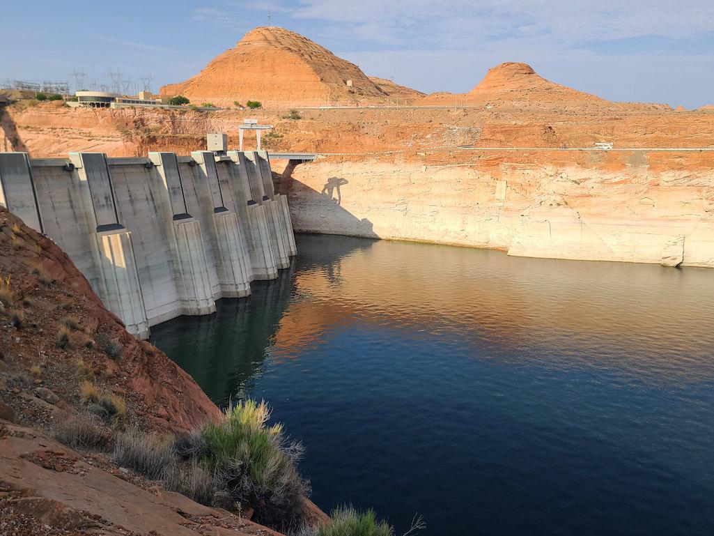
Glen Canyon Dam August 2021. The white on the sandstone reflects where the water level once was. Dropping levels at Lake Powell are forcing a reduction in outflows from the Glen Canyon Dam. Photo credit: USBR
As the crisis on the Colorado River continues, the U.S. Bureau of Reclamation and the four Upper Basin states—Colorado, New Mexico, Utah and Wyoming—have drawn up a proposed framework called the Upper Basin Drought Response Operations Plan. The framework would be used by water managers to create plans each year, as necessary, to maintain Lake Powell water levels.
The effort to keep Lake Powell healthy is critical to ensuring hydropower production from its turbines is maintained and to protect the Upper Basin states from violating their legal obligation to send Colorado River water to Arizona, California and Nevada, the Lower Basin states.
Whether the new plan will be activated this year is uncertain. During a webinar about the working draft on Jan. 28, Rod Smith, an attorney with the U.S. Department of Interior, described this year’s early winter weather as a yo-yo. “December was excellent,” he said, “but January was kind of blah.”
Lake Powell’s water levels were successfully stabilized last year after a series of major emergency water releases from reservoirs in Utah and Colorado. Lower Basin states also cut water use.
Graphic credit: Chas Chamberlin
Modeling last year had found a nearly 90% probability that Powell levels in 2022 would fall below the elevation of 3,525, triggering more emergency releases. But as of Feb. 3, water levels in Powell were almost 6 feet above that elevation.
Much can change between now and April, when Reclamation and the states hope to complete the framework.
Last year’s disastrous runoff — the snowpack was roughly 85% of average but the runoff was 32% of average — surprised everyone, and ultimately forced the emergency releases from Blue Mesa and Flaming Gorge, two of three federal dams operated by the agency upstream of Powell. Reclamation also operates Navajo, the reservoir located primarily in New Mexico, whose waters can also be used to boost levels in Powell, subject to other limitations.
The proposed framework identifies how much water from the three reservoirs is available for release to prop up levels in Powell, but only after operations at Powell itself have been managed to best maintain levels of 3,525 feet or above. To slow the decline, Reclamation is holding back 350,000 acre-feet of water in Powell that it would normally release during January-April.
The agency plans this year to release 7.48 million acre-feet from Powell to flow down the Grand Canyon to Lake Mead.
Smith emphasized that the releases from Blue Mesa and other Upper Basin reservoirs will be subordinate to the many preexisting governance mechanisms on the Colorado River, including treaties, compacts, statutes, reserve rights, contracts, records of decision and so forth. “All that stays,” said Smith.
Taylor Park Reservoir
This can get complicated. For example, some water from Taylor Park Reservoir, near Crested Butte, can be stored in Blue Mesa but is really meant for farmers and other users in the Montrose-Olathe area. That water is off-limits in this planning.
Navajo Reservoir, New Mexico, back in the day.. View looking north toward marina. The Navajo Dam can be seen on the left of the image. By Timthefinn at English Wikipedia – Transferred from en.wikipedia to Commons., Public Domain, https://commons.wikimedia.org/w/index.php?curid=4040102
Navajo Reservoir releases can get even more complicated. Water was initially identified last summer for release from the reservoir to help replenish Powell, but then delayed. Reasons were identified, including temperatures of the San Juan River downstream in Utah. But feathers were ruffled, as was revealed during the Colorado River Water Users Association meeting, held in Las Vegas in December. Tribes were consulted only belatedly.
Now, the draft framework language specifies the need for consultation with tribes. Water in Navajo Reservoir is owned by both the Jicarilla Apache and Navajo. To be considered are diversions to farmers but also to Gallup. “Getting this right, particularly in the operational phase, will be critical,” said Smith.
How might this affect ditch systems in Colorado? “There will be timing issues of when the extra water comes down, but in terms of whether there are any direct impacts to a ditch authority operating under its own decree, there should not be,” said Michelle Garrison, senior water resource specialist with the Colorado Water Conservation Board, during the webinar. “We don’t expect any disruption to other water users because of this.”
[…]
“You can help make the best of a bad situation by having any drought operation releases benefit other things on the river, including benefits to threatened and endangered fish species while potentially producing more hydropower revenue [used in part to support endangered fish recovery programs],” said Bart Miller, water program manager for Western Resource Advocates.
But Miller and others also note that Reclamation’s draft framework represents a short-term solution to a festering long-term problem.
Brad Udall: Here’s the latest version of my 4-Panel plot thru Water Year (Oct-Sep) of 2021 of the Colorado River big reservoirs, natural flows, precipitation, and temperature. Data (PRISM) goes back or 1906 (or 1935 for reservoirs.) This updates previous work with @GreatLakesPeck.
The word drought is found everywhere in the planning documents. Colorado State University climate scientist Brad Udall insists that another word, aridification, better describes the hydrology that has left the Colorado River with nearly 20% less water in the 21st century as compared to the 20th century. Trying to reconcile 21st century hydrology with 20th century infrastructure and governance is like walking on a rail that gets ever more narrow.
“I think it’s totally appropriate to use this tool but not as a substitute for dealing with the overall imbalance between supply and demand,” says Anne Castle, a senior fellow at the Getches-Wilkinson Center for Natural Resources, Energy and the Environment at the University of Colorado Law School.
Long-time Colorado journalist Allen Best publishes Big Pivots, an e-magazine that covers energy and other transitions in Colorado. He can be reached at allen@bigpivots.com and allen.best@comcast.net.
Here’s the release from the NRCS (Brian Domonkos):
Mountain snowpack accumulations across Colorado have slowed down since the beginning of the year but conditions are generally surrounding normal across the major river basins. That said, it is important to note that percent of normal values have been updated from the 1980-2010 period to 1990-2020 so there are changes in comparison to the last decade. This change is a standard across many other water and climate monitoring networks across the country which helps with consistent reporting and comparability.
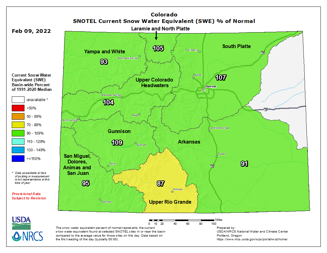
Colorado snowpack basin-filled map February 9, 2022 via the NRCS.
Currently Colorado statewide snowpack is 100 percent of normal (median) with some variation basin to basin but with not as much variation as has been observed over the last several years. Snowpack ranges from a low of 89 percent of normal in the Upper Rio Grande to a high of 110 percent of normal in the Gunnison River Basin. Statewide this is 60 percent of the median peak accumulation that is generally observed in early April.
Water year to date precipitation, starting October 1st, is very similar to snowpack at 103 percent of normal. NRCS hydrologist Karl Wetlaufer notes that “While the current conditions are encouraging it is important to consider that due to the multi-year drought can effect snowmelt runoff. Dry soil conditions going into winter can reduce the observed streamflow relative to what the observed peak snowpack ends up being.”. Streamflow forecasts are currently lower than snowpack levels, as would be anticipated given the conditions going into winter.
In the big picture of water supply and water availability reservoir storage is also currently a major consideration in Colorado. Southwest Colorado currently has the lowest reservoir storage in the state with 59 percent of normal in the Gunnison and 64 percent in the combined San Miguel, Dolores, Animas, and San Juan Basins. The most plentiful reservoir storage in in the South Platte at 112 percent of normal. Wetlaufer continued to note “In addition to the reservoirs within the state it should also be kept in mind that Lake Powell and Lake Mead, are also at the lowest levels on record which has an effect on the entire Colorado Basin and can continue to affect the headwaters here in Colorado.” There is still much potential snowpack accumulation season to come but changing water supply conditions should still be closely watched.
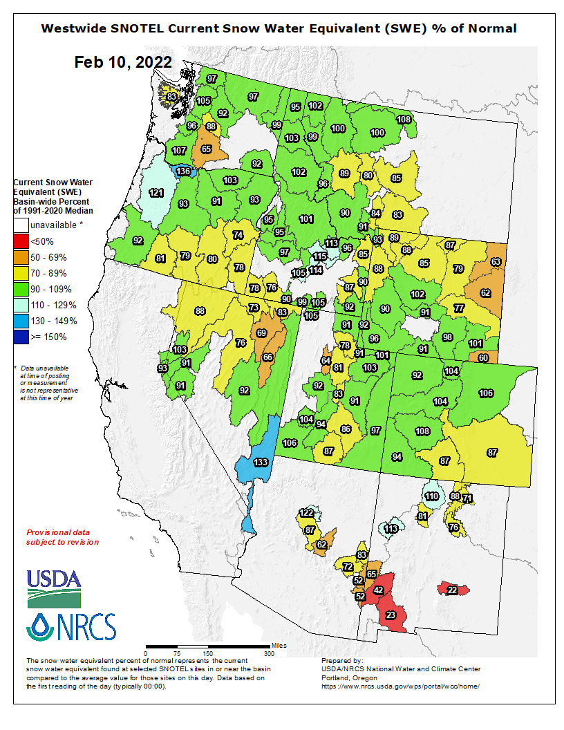
Westwide SNOTEL basin-filled map February 10, 2022 via the NRCS.
A Colorado pikeminnow taken from the Colorado River near Grand Junction, and in the arms of Danielle Tremblay, a Colorado Parks and Wildlife employee. Pikeminnows have been tracked swimming upstream for great distances to spawn in the 15-mile stretch of river between Palisade and Grand Junction. An apex predator in the Colorado, pikeminnows used to be found up to six feet long and weighing 100 pounds. Photo credit: Lori Martin, Colorado Parks and Wildlife via Aspen Journalism
Hydropower dams blocked the fish’s migrations for spawning, altered river flow and churned cooler water downstream. The Colorado pikeminnows, which were not accustomed to the cooler waters, were soon outcompeted for food by nonnative fish. Now, most Colorado pikeminnows reach only two to three feet long.
“Those fish are now endangered and have been replaced with cold-water-adapted trout,” said Gordon Holtgrieve, a fish ecologist at the University of Washington. “The river doesn’t look anything like it used to, and Native Americans of the region, who traditionally used these fish, have lost part of their culture.”
[…]
The ubiquitous dams around the world are built to guard against extreme flooding, meet steadily increasing water demands and provide hydroelectric power. They also alter river ecosystems — such as by changing temperatures downstream — and can substantially change nearby fish populations…
Worldwide, at least 3,700 medium and large hydropower dams are planned in the coming decades or under construction, heavily concentrated in South America, Africa and South and East Asia. Hundreds of millions of people in large river basins in these areas rely heavily on the river for their livelihoods, Holtgrieve said. For example, Cambodians receive about 80 percent of their animal protein from primarily wild-caught freshwater fish from the Mekong River.
Now, in a recent study, researchers have created a first-of-its-kind machine learning model that can predict temperature changes as a result of dams planned around the globe and could help planners and engineers mitigate the environmental impact. Analyzing future dams worldwide, the team found some dams changed downstream temperatures by as much as 10.8 degrees Fahrenheit (6 degrees Celsius).
Based on the research, the team created a public tool that allows people to plug in the dimensions of a future dam and learn how it will affect downstream temperatures.
The current snowpack is running at just about normal levels in the highest elevations of the Eagle River watershed. But that isn’t great news.
The snowpack readings haven’t been bolstered by significant snow in some time, and there doesn’t seem to be much relief on the horizon.
According to Lucas Boyer, a meteorologist at the Grand Junction office of the National Weather Service, a ridge of high pressure over the Pacific Ocean just off the West Coast of the United States is keeping moisture from heading toward Colorado…
Meteorologists generally don’t predict with confidence past seven to 10 days. That’s the job of the U.S. Climate Prediction Center. There isn’t much good news coming from that office. That agency’s most recent prediction for the next three to four weeks calls for “equal chances” of either above- or below-average precipitation for all but the farthest northwest corner of the state. The Climate Prediction Center is also calling for a chance of above-average temperatures for the state…
Colorado Drought Monitor February 8, 2022.
A U.S. Drought Monitor report from Feb. 1 notes that much of the Intermountain West remains in some form of drought. In Colorado, 19% of the state is in “extreme” drought. Parts of Eagle and Summit counties are listed as being in a “severe” drought…
That’s bad news for streamflows during the spring and summer. A Feb. 3 report from the National Oceanographic and Atmospheric Administration indicates that the upper Colorado River will supply users with between 80% and 105% of normal supplies.
Diane Johnson, the communications and public affairs manager with the Eagle River Water & Sanitation District, said while snowpack is holding at near-normal levels, that could be due to cold temperatures — we’re in the middle of winter, after all — and the fact that the 30-year snowpack median is lower than it was five years ago.
Johnson said lower streamflows, especially given that dry soils will absorb melting snow before it hits local streams, are a continuing worry for the district.
Dry conditions are also a worry for local fire departments. Johnson said a proposal in Vail to require all buildings to have a 5-foot buffer can help. But, she added, more help could come from people changing the way they plant for outdoor landscaping.
Water sustains the San Luis Valley’s working farms and ranches and is vital to the environment, economy and livelihoods, but we face many critical issues and uncertainties for our future water supply. (Photo by Rio de la Vista.)
Here’s release from Adams State University (Linda Relyea, Rio de la Vista):
“In Scarcity, Opportunity for Community” is the theme for the Salazar Rio Grande del Norte Center hosted Rio Grande State of the Basin Symposium this year. These words, from the pen of the late Justice Greg Hobbs, are as timely as ever, as the San Luis Valley faces water scarcity from several directions. In the past, whenever we’ve faced risks, this community comes together to protect our water future. This is the opportunity ahead, if we are able to rise to it.
What is the status of our water supply, current threats and opportunities? We’ll provide updates, information and future forecasts for 2022 at the fourth annual “Rio Grande State of the Basin Symposium.” It will be held virtually, Saturday, February 26th, from 9 am to 1 pm. Co-hosted by the Salazar Rio Grande del Norte Center at Adams State University and the Rio Grande Water Conservation District, the event is free and open to the public. The Symposium is also a featured program of the Adams100 series, celebrating the first 100 years of Adams State University. Register on-line here to receive a Zoom link to the event.
Keynote Speaker for the 2022 Rio Grande State of the Basin Symposium: Dr. Maria E. Montoya. Photo credit: Adams State University
Dr. Maria E. Montoya to be Keynote Speaker
“We’re looking forward to hearing a new voice and a global perspective on water scarcity and communities from our keynote speaker this year, historian Dr. Maria E. Montoya in her presentation, ‘A Look at Water Scarcity Globally: From the American West to China’,” said Salazar Center Director Rio de la Vista. With family roots in the San Luis Valley and the southwest, Maria E. Montoya is a Global Network Associate Professor of History at New York University and the Dean of Arts and Sciences at NYU Shanghai. She earned her BA, MA and PhD degrees at Yale University. Her research explores how workers and families in the nineteenth and early twentieth centuries have used natural resources to make a living and make their homes in particular places in the American West, with numerous books and articles published on these topics. Dr. Montoya is currently working on another book project about the scarcity of water in the American Southwest and the Rio Grande.
Symposium Agenda Overview
“We’re very pleased to have long time Adams State business professor and newly appointed State Director for the USDA’s Colorado Office of Rural Affairs, Armando Valdez as our Master of Ceremonies,” said de la Vista, “As a multigenerational farmer/rancher from the Capulin area, a water leader, educator and now statewide leader, he brings his valuable perspective to the whole event.”
The morning will begin with a report on the current “State of the Basin,” including the latest data on snowpack measurements and flow forecasts by Division Engineer, Craig Cotten with the Colorado Division of Water Resources. He will also provide information about the state of our groundwater and related challenges. Given the various aspects of community and water scarcity facing our community now and in the time ahead, the Symposium agenda will address three key causes of water scarcity and the community’s response to them: the state of the Valley’s aquifers and subdistricts, the current threat of water exportation, and the changes being experienced due to climate change.
The session on “What’s up with the aquifers?” will include a panel addressing the status of the aquifers and the work of the Groundwater Management Subdistricts to achieve ground water sustainability. Amber Pacheco from the Rio Grande Water Conservation District, George Whitten, rancher and water leader in Saguache County, and Charlie Goodson of Colorado Open Lands will answer questions on these issues.
For the session on “What’s up with the water exportation threat?”, Heather Dutton, Manager of the San Luis Valley Water Conservancy District will give an update on the latest developments with the proposal to move SLV water to Douglas County. Michael Carson of the Rio Grande Water Conservation District will let participants know how they can learn and engage in the collective effort to prevent exportation and the collaborative protectsanluisvalley.com information source.
“What’s happening with climate change?” will be addressed by well known journalist and author Laura Paskus, drawing from here recent book, “At the Precipice: New Mexico’s Changing Climate,” which was published in September 2020 by the University of New Mexico Press. Based in Albuquerque, New Mexico, Paskus is the environment reporter for New Mexico PBS, and produces the monthly series, “Our Land: New Mexico’s Environmental Past, Present and Future.”
The program will also include information about the Rio Grande Basin Roundtable’s newly completed Rio Grande Basin Implementation Plan from Emma Reesor of the Rio Grande Headwaters Restoration Project. Becky Mitchell, Director of the Colorado Water Conservation Board will update on the new version overall Colorado Water Plan. State Senator Cleave Simpson will share the latest on water bills at the Colorado State Legislature. The program will also provide information about the Salazar Rio Grande del Norte Center’s upcoming water education programs for Adams State and the community.
Hosts and Sponsors
The Salazar Center and the Rio Grande Water Conservation District are co-hosts of the annual Rio Grande State of the Basin Symposium, with generous support from the Colorado Water Conservation Board. Symposium sponsorships from the SLV Chapter of Trout Unlimited, the Conejos Water Conservancy District, the SLV Irrigation District, the SLV Water Conservancy District, Colorado Open Lands, Headwaters Alliance and generous individual donors all help make this event possible and free to the community.
To register and for more information about the 2022 Rio Grande State of the Basin Symposium, click here. Interested citizens can also follow the Salazar Rio Grande del Norte Center on Facebook for regular updates on water issues and get information about Water Education program at Adams State University at http://www.adams.edu/about/salazar-center/ or contact them directly at salazarriograndecenter@adams.edu.
To learn even more about water issues in the Rio Grande, videos of previous year’s presentations from the 2019, 2020, and 2021 Rio Grande State of the Basin Symposiums and other past water talks are all available online at: https://www.youtube.com/playlist?list=PLM1XIDdQr4T5uncIUerKvQUhESIzAcfoO. The 2022 Symposium recordings will be posted there as well, as part of the Salazar Center’s on-going work to develop a Rio Grande Library of water information and resources.
San Luis People’s Ditch March 17, 2018. Photo credit: Greg Hobbs