Governor Mark Gordon has announced the appointment of Brandon Gebhart as Wyoming State Engineer. Gebhart was appointed interim State Engineer in December and previously served as the Director of the Wyoming Water Development Office.
Wyoming river basin map. Credit: The Wyoming Geological Survey
The State Engineer serves as the chief water official in the state and is responsible for the general supervision of Wyoming’s waters, including technical, policy and regulatory matters concerning its beneficial use.
Gebhart is a native of Wheatland, Wyoming and has spent more than 20 years in consulting engineering, primarily working in the field of water resources. He earned a Civil Engineering degree from the University of Wyoming and is a licensed Professional Engineer.
“Brandon is the right person for this job: he has an outstanding technical background in water resources and civil engineering; a firsthand understanding of Wyoming water issues; and brings a can-do attitude that supports the needs of Wyoming’s water users,” Governor Gordon said. “In this day and age, to serve as Wyoming State Engineer requires a unique set of skills. I am proud to welcome Brandon to lead the way and protect Wyoming’s water interests.”
“It is an honor to be asked to serve as the State Engineer,” Gebhart said. “These are very interesting times and I am excited to be a part of helping Wyoming continue to use and develop our water resources.”
Gebhart’s appointment is subject to confirmation by the Wyoming Senate, with a term that runs through February 28, 2023.
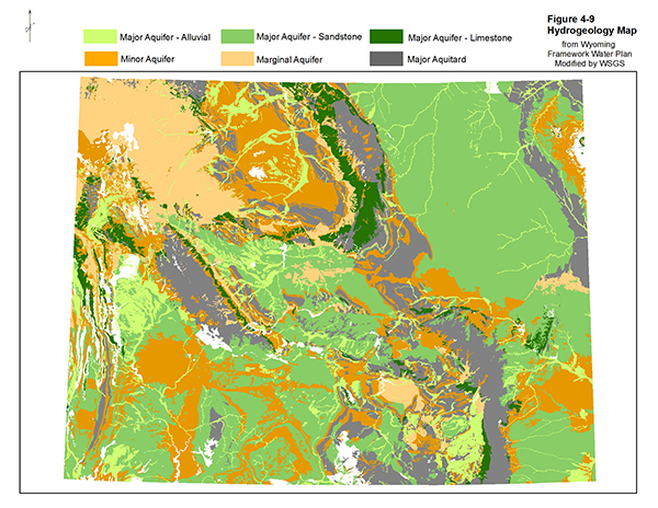
Wyoming hydro-geological map. Credit: The Wyoming Geological Survey
Lake Powell could soon see its level drop below the critical elevation where the Glen Canyon Dam stops being able to generate power.
In the weeks since, however, snowfall throughout the watershed has been at a record or near-record low. Lake Powell, which is filled to just over a quarter of its capacity, could soon see its level drop below the critical elevation where the Glen Canyon Dam stops being able to generate power, even after this week’s storms…
Snowpack in the upper Colorado River basin was above average after big December storms, but an exceptionally dry January and February has water managers worried about levels in Lake Powell and other reservoirs…
Heather Patno, a hydrologist with the Bureau of Reclamation, which oversees operations at Lake Powell, compared the snow season to a yo-yo or a roller coaster that has required forecasts to be repeatedly revised.
The latest projections, Patno told a Glen Canyon Dam working group earlier this month, predicted runoff into the Colorado River will be around 76% of average, and, unless more storms arrive soon, that could drop to 59% of average…
The low range of probable forecasts, Patno said, show that hydropower generation at the dam may become impossible before the end of 2022, marking an uncertain new reality for the 40 million people who rely on Colorado River water between Denver and Tijuana…
Brad Udall: Here’s the latest version of my 4-Panel plot thru Water Year (Oct-Sep) of 2021 of the Colorado River big reservoirs, natural flows, precipitation, and temperature. Data (PRISM) goes back or 1906 (or 1935 for reservoirs.) This updates previous work with @GreatLakesPeck.
In a letter sent to Reclamation last month, John Weisheit and Robin Silver, co-founders of Living Rivers and the Center for Biological Diversity respectively, wrote that demand for water in the basin has outpaced supply for over two decades as the Southwest has been locked in a cycle of megadrought.
The ultimate goal of water managers, according to Weisheit and Silver, should be to “balance the water budget” by immediately reducing consumptive water use in the basin by 20%. Temporarily tweaking release schedules from Lake Powell, the letter said, will not solve the underlying issue that the basin states are using more water than is actually available in the river.
Click the link to read the article on The Craig Press (Eliza Noe). Here’s an excerpt:
As industries across the Western Slope continue to watch snow and water levels as the days until summer close in, the Colorado River District hosted water experts Tuesday to discuss what certain data points mean and how they reflect the current state of Colorado’s water levels…
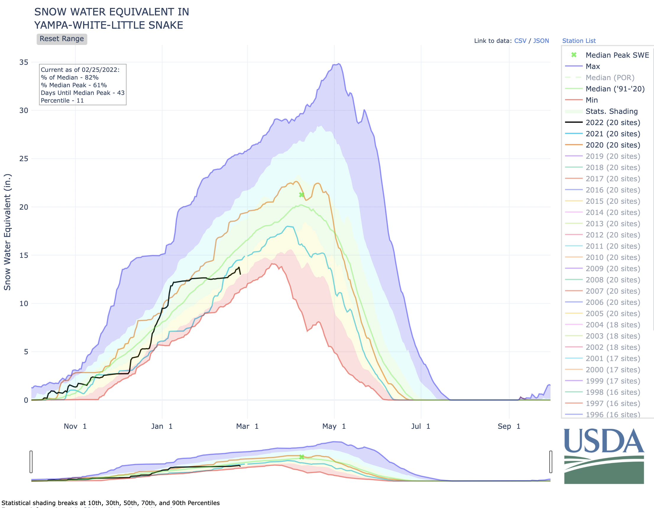
Before Monday, snow in 2022 had been sparse for the northwest corner of the state. According to the USDA’s Natural Resources Conservation Service, the White and Yampa River Basin is currently at 86% of the median snowpack level since 1991. To get this median, the NRCS takes all of the snow patterns over the past 30 years and finds the middle of all of the peaks and snowpack levels. This median is often used as a standard to measure how dry a year is…
This winter, snow water equivalent (SWE) levels for the White-Yampa Basin are currently at 13.4 inches as of Tuesday (the latest available data). SWE is a commonly used measurement used by hydrologists and water managers to gauge the amount of liquid water contained within the snowpack. In other words, it is the amount of water that will be released from the snowpack when it melts.
The SWE median for that same date is 15.5 inches, and this year is slightly behind last winter’s levels, which was at 14.4 inches. The median peak of these levels (meaning the highest amount of SWE levels before they dip) usually happens around April 8. During the most recent drought, this peak has happened earlier in the year, and it sometimes does not reach that average peak, either. In 2021, the peak of snowpack happened during the last week of March, topping at 18 inches. The median peak is 23.1 inches…
“One thing to keep in mind is that the percentage of normal numbers based on the SNOTEL network and snow course measurements are used for runoff prediction,” [Jeffrey] Deems said. “They are not a SWE volume measure. And so they’re used in a statistical forecasting method by the NRCS to project April through July runoff.”
A stock pond that is normally full of water stands dry because of drought on the Little Bear Ranch near Steamboat Springs, Colo., on Aug. 11, 2021. Due to low snowpack, warming temperatures and dry soil during the past two years, followed by the same in 2021, Northwest Colorado is in a severe drought. Credit: Dean Krakel, special to Fresh Water News.
[…]
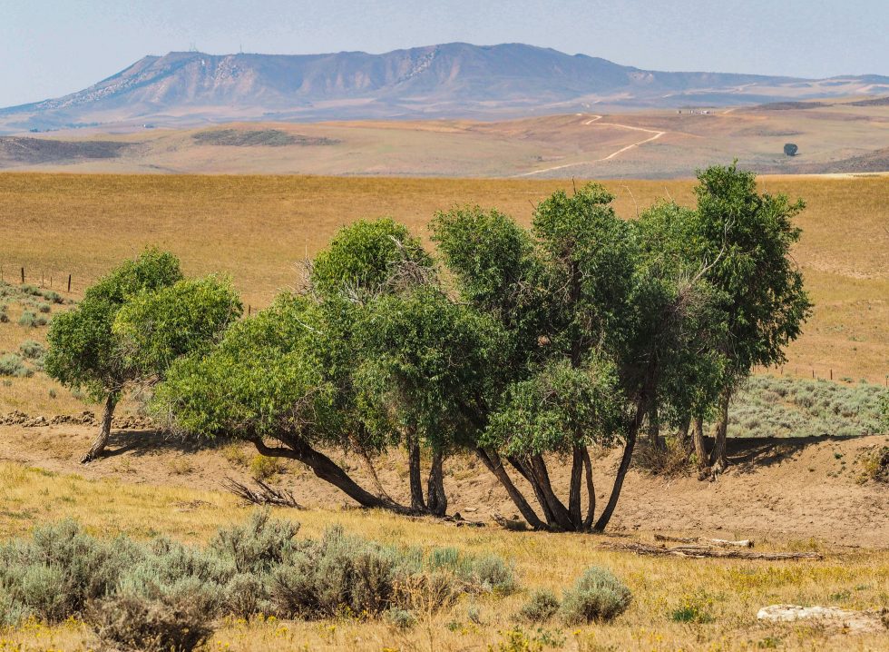
Across the entire western part of the United States, the trend of a multi-decadal drought is continuing. Gov. Jared Polis visited Craig last summer to speak with local ranchers about the drought’s impact on the Yampa Valley. Currently, agriculture workers in different facets of the industry are looking to see if 2022 might provide some relief.
Fort Lyon Canal Company has seen a storm of litigation, brushes with debt, and general upheaval in its 125 years of existence. It is a credit to its survival the company has issued a commemorative medal to the farmers and landowners owing their very existence to the water sources and reservoirs developed over 125 years. Judy Hensley received one of these medals, as her land, farmed by Nate Cranson, is one of the beneficiaries of that precious water.
Straight line diagram of the Lower Arkansas Valley ditches via Headwaters Magazine
The headwaters and the main gate of the Fort Lyon Canal, the longest and most complicated canal in Colorado, is located just north of North La Junta. “The Fort Lyon Canal’s first 100 years” by O. Ray Dodson is a document based on the 1910 report on “Property of The Fort Lyon Canal Company” by James D. Schuyler, and is the source of historical information gathered by Chris Woodka, former water reporter for the Pueblo Chieftain and now with the South East Water Conservancy District.
The canal, at the time of Dodson’s writing, had a total length of about 113 miles from its head gate to the extreme end at Big Sandy Creek east of Lamar. The principal supplier of water is the Arkansas River, but some of the sources are upslope at Horse Creak Reservoir and other reservoirs developed over the years.
The battle for the water that flows in the Fort Lyon Canal continues to the present time. High Plains A&M, a group of investors led by entrepreneur Terry White, began quietly buying shares in Fort Lyon Canal about five years ago. “It owns or controls 28,566 of the canal’s 98,989 shares, about 30 percent,” wrote Chris Woodka recently. “Its plan, rejected Monday by the Colorado Supreme Court, was to market the water in 28 counties within and outside the Arkansas Valley. Most of the uses listed were domestic or municipal. High Plains owns 115 farms on the canal, directly controlling more than 20,000 shares. It secured options on the remaining shares.”
Woodka further wrote: “The Independent Shareholders Group is aligned with High Plains, which is paying its legal expenses. The ISG owns another 8,287.5 shares of the ditch, about 9 percent, and includes 45 landowners.
• High Plains filed for its change of use decree in late 2002. In November 2003, Fort Lyon shareholders – after five days of hearings – approved diverting water from the canal, as long as it was taken “in priority” along the canal.
• Pueblo Chief District Judge Dennis Maes dismissed change-of-use applications by High Plains and ISG on July 2, 2004. High Plains appealed that decision on Aug. 17, 2004. Oral arguments were held in June. The Colorado Supreme Court upheld Maes’ decision Monday.”
The decision rendered by Pueblo Chief District Judge Dennis Maes was argued for the Lower Arkansas Water Conservancy District by the late Bart Mendenhall of Rocky Ford and Peter Nichols, still the main attorney for LAVWCD.
The May Ranch near Lamar, Colo., has never been plowed. Photo/Ducks Unlimited via The Mountain Town News