The health of our waters is the principal measure of how we live on the land — Luna Leopold
#Drought news (February 10, 2022): Widespread improvements to eastern #Colorado
Click on a thumbnail graphic to view a gallery of drought data from the US Drought monitor.
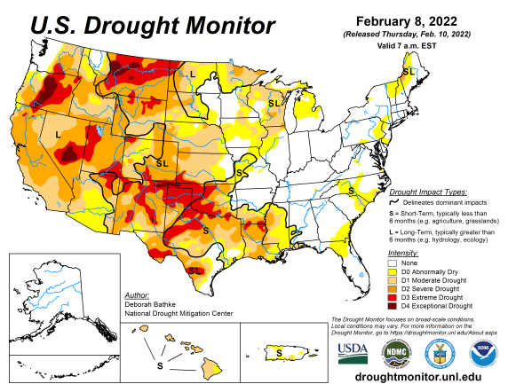
US Drought Monitor map February 8, 2022.
High Plains Drought Monitor map February 8, 2022.
West Drought Monitor map February 8, 2022.
Colorado Drought Monitor map February 8, 2022.
Click here to go to the US Drought Monitor website. Here’s an excerpt:
This Week’s Drought Summary
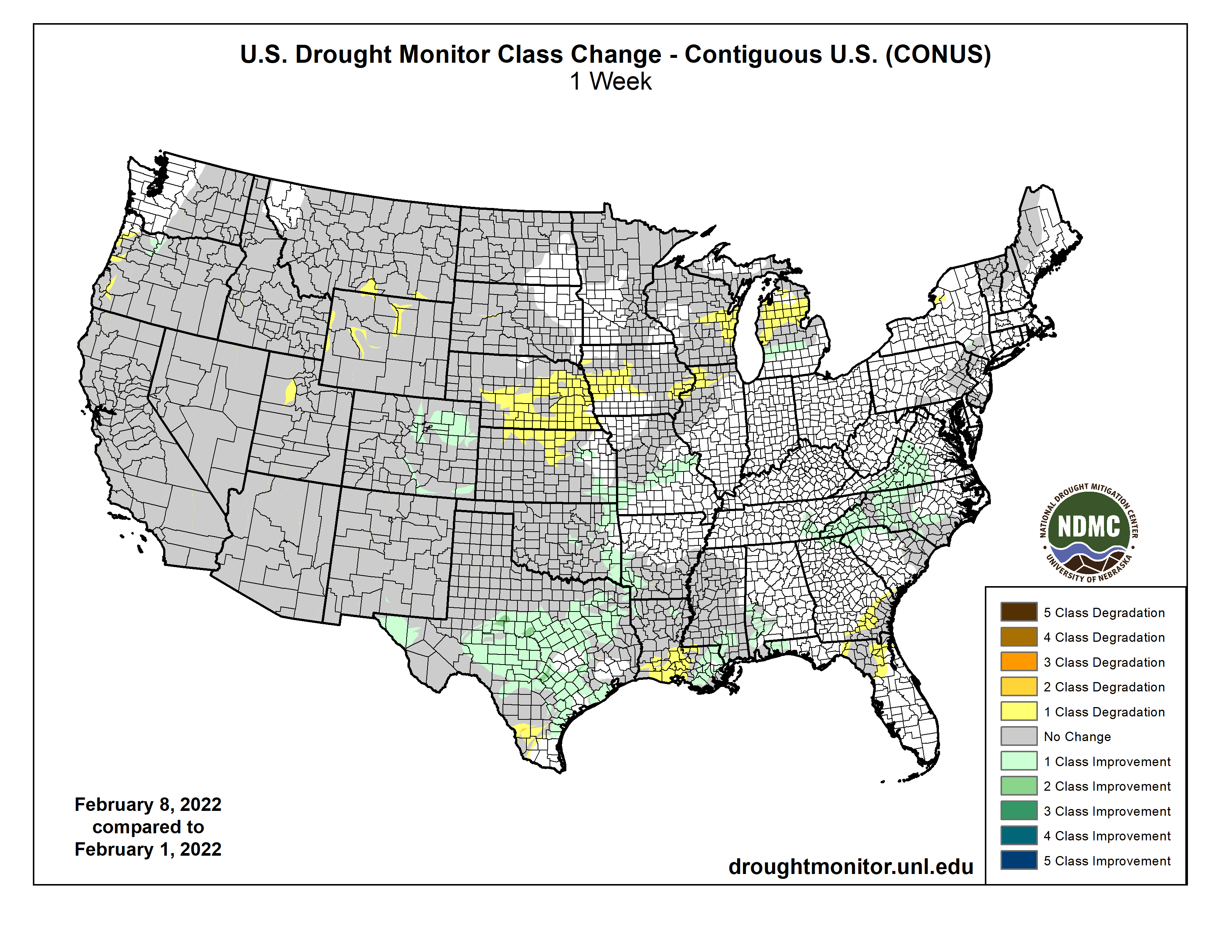
A powerful winter storm last week, stretching from New Mexico to Maine, helped improve drought conditions in 17 states in its path. Meanwhile, another week of dry weather in the West put a halt to drought recovery. Parts of Montana, Wyoming, Utah, and Oregon saw drought expand as the recent dryness on top of long-term drought chipped away at snowpack and lowered streamflow. A wet December left most other parts at near normal for the season, but concerns are growing as dry weather remains in the forecast…
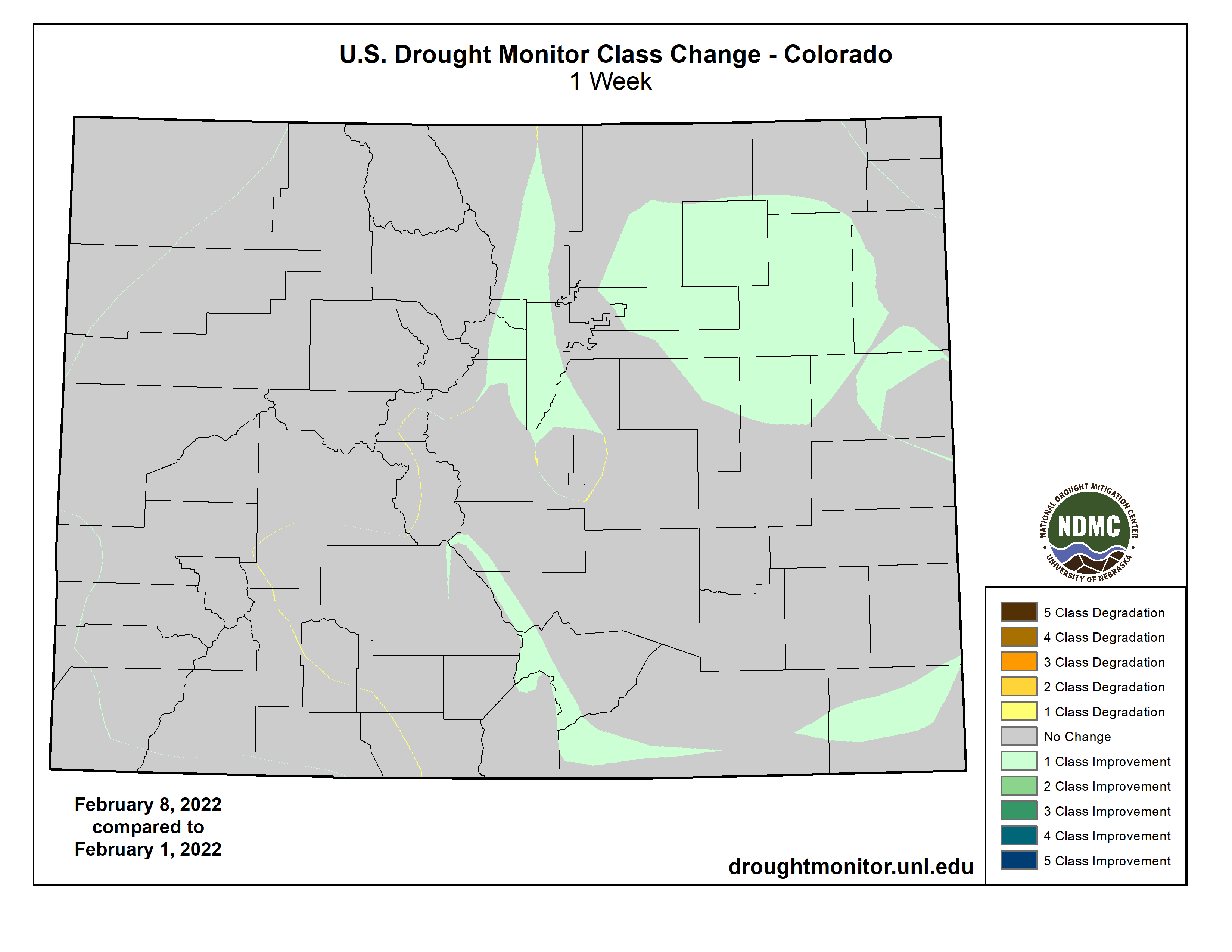
Last week’s snow brought widespread improvements to eastern Colorado including areas of severe (D3) and extreme drought (D3). The recent event, combined with above average January snowfall, has left a large swath of snow on the ground and improved soil moisture conditions. The remainder of the region saw another week of dry weather. Wyoming saw an expansion of D2 and D3 in the north and west parts of the state as recent warm, dry weather, chipped away at seasonal snowpack. Nebraska and Kansas saw a broad expansion of moderate drought (D1) and abnormal dryness (D0). Here, 30-to-90-day precipitation totals rank in the top 5 driest on record. Fires on the rise in these areas and burn bans are going to effect…
Colorado Drought Monitor one week change map ending February 2, 2022.
Weather across the West was once again dry this week. Western Oregon saw expansions to moderate (D1) and severe (D2) drought increased. Another week of dry weather increased water-year-to-date precipitation shortfalls and lowered streamflow values. The far northern Oregon Cascades saw improvement. Snowpack here is near normal for the water year. Extreme drought (D3) was expanded in Utah as increasing precipitation deficits have dried out soils and lowered streamflow. The rest of the West remains unchanged. Several weeks of dry weather has caused high elevation snowpack in parts of the west to drift away from the above-normal values at the start of the new year…
Much needed rain brought by last week’s winter storm improved drought conditions in parts of all six states in the region. Precipitation totals of around 1 to 4 inches – more than 300% of normal in some areas – fell across much of the region helping to reduce short-term rainfall deficits and improve streamflow and soil moisture conditions. Texas saw a wide band of 1-category, with isolated 2-category, improvements. In parts of South and West Texas, the excess moisture was enough to chip away at the long-term drought. Other areas seeing improvements include eastern Kansas, eastern Oklahoma, southeastern Louisiana, and southern Mississippi. Widespread drought remains in the region. Despite last week’s weather, parts of Texas and Louisiana saw expansions of drought. These areas missed out on the heaviest rain, increasing moisture deficits. In South Texas rainfall deficits are approaching 5 to 6 inches (less than 50% of normal) over the last 3 months. In southwest Louisiana, they are about 7 to 10 inches (less than 50 % of normal) over the same time frame, reducing streamflow and drying soils…
Looking Ahead
The National Weather Service Weather Prediction Center forecast (valid February 10 – 15) calls for relatively dry weather over much of the Lower 48. A pair of storms systems are expected to bring snow to the Upper Midwest and Northeast. Much of the continental U.S. will see above normal temperatures through the weekend. Moving into next week, the Climate Prediction Center (Valid February 15 – 19) Outlooks favor above normal precipitation from the Desert Southwest northeast to the Canadian border. Drier weather is favored for the northern Plains and much of the west. Temperatures are expected to be warmer than normal in the West Coast states, the central and northern Great Plains, and across much of the Lower Midwest and Southeast.
US Drought Monitor one week change map ending February 8, 2022.