Click the link to read the article on the Colorado Newsline website (Shannon Tyler):
Lyons and Estes Park community members reflect on damage and recovery from deadly natural disaster
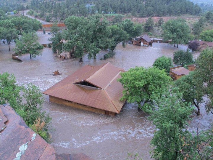
In early September 2013, after a storm stalled over the Front Range, rivers rose out of their beds and rushed right through several Northern Colorado communities, resulting in one of the state’s worst floods.
Meteorologists classified it as the kind of flood that happens only once every 500 or more years.
From Sept. 9 until Sept. 16, the Front Range experienced uncharacteristically heavy rainfall, which flooded several communities, resulting in nine deaths, 11,000 people evacuated, 1,850 destroyed homes and about $4 billion in damages across the state, with 18 counties declared federal disaster areas, according to the Colorado Encyclopedia.
From the initial damage of the flood and the difficult recovery period to later commemorations, the 2013 flood has stayed with many people as a painful memory 10 years on. On this anniversary, communities are reflecting on lessons of the flood and its story of resilience amid tragedy.
A ‘biblical’ flood
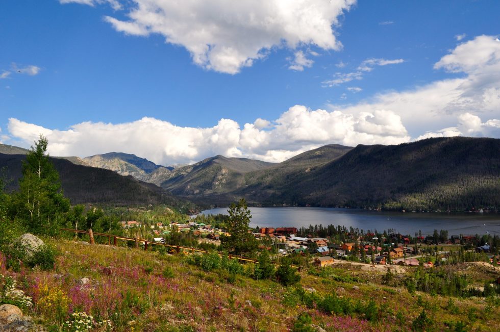
Sitting at the intersection of the North St. Vrain and South St. Vrain creeks, the small mountain town of Lyons was one of the hardest hit communities.
Victoria Simonsen, the town administrator for Lyons, stepped into the role in 2013 prior to the flood and stayed in the position, helping the town recover ever since.
She said the whole town went to bed the night of Sept. 11, 2013, with the creeks at a normal level and no suspicion of the disaster that was to come.
“We were watching the creek, but we were not in any kind of panic mode at all,” Simonsen said.
It was in the late hours of that night, however, when the flooding started. At about 11 p.m. the water rose above the river beds, Simonsen said.
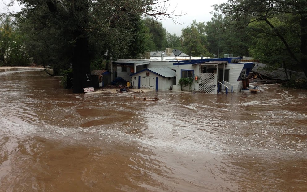
Usually local creeks hit low flooding levels when the water flows at 1,200 cubic feet per second, she said. By the end of the event, Lyons’ two creeks were flowing at 26,000 cubic feet per second. Simonsen said it was true flash flooding, and the water went from ankle deep to 12 feet deep very quickly.
“This was classified as between a 500 and 1,000 year event. The National Weather Service actually called it biblical in Lyons,” Simonsen said.
But it wasn’t until 2 a.m. that the town’s flood sirens actually went off, Simonsen said.
That was also when the water, which was rushing down from 14,000-foot mountains to the town at 5,300 feet, completely isolated neighborhoods and took out all three access points into town.
“The water came through the town at 2 a.m. and it literally divided our community into five islands,” Simonsen said.
The siren system sounded based on population, not location along the rivers, and when many residents woke to the sirens, Simonsen said she got calls from people saying the river was flowing in front of their homes, trapping them.
“We were stranded on our island for about 36 hours before we were able to get contact, and then the National Guard started arriving by helicopter and high water vehicles,” Simonsen said.
About 20 miles northwest, further into the Rocky Mountains, the Big Thompson River rushed through Estes Park and communities along the Big Thompson Canyon around the same time.
“It was the middle of the night I got a call saying it’s gonna be bad, so we opened up an emergency operations center,” Frank Lancaster, the Estes Park town administrator at the time and current trustee.
In the tourist town outside of Rocky Mountain National Park, two rivers and several creeks run through town, and one after another started flooding.
“We were dealing with one and then the other one came up and then basically all hell broke loose everywhere and couldn’t get in or out of town,” Lancaster said.
The only road in or out of Estes Park was Trail Ridge Road, a winding, small road that goes through the national park.

“Because the flooding was so widespread, the county was affected everywhere. So we really didn’t have much assistance from the county, because they couldn’t get up here and they were dealing with other places,” Lancaster said.
The National Park Service became their lifeline. Rangers helped sandbag the town to protect vital infrastructure and bring in materials.
Lancaster said the population in Estes Park is older, and when he went door-to-door to check on people he was surprised to find a lot of residents who were isolated and didn’t realize there was flooding.
Around Boulder County and Larimer County, communities large and small started calling for help.
Joe Pelle, then the Boulder County sheriff, said it was the first time in his career that deputies were unable to get to people in need.
He said during his tenure, he helped create a robust emergency management system and even went through several simulations of floods. None of these simulations could have prepared deputies for this kind of catastrophe, because almost all access to mountain communities was wiped out. In all of the simulations, Pelle said, first responders were able to create an alternate route.
“That night, one after another, all of the canyon roads failed or washed away in places and within a matter of a few hours,” Pelle said. “There was literally no access to our folks who live in the mountains.”
First responders couldn’t reach people in medical emergencies for a day and a half, Pelle said.
The unusual weather pattern, a prolonged rain storm in early September, that loomed over Northern Colorado was what experts call a cut-off low pressure system, according to Andreas Prein, a scientist with the National Center for Atmospheric Research in Boulder.
Prein said these systems can be dangerous, because whatever weather the system brings, it will last for days.
The storm lasted from Sept. 9 to Sept 16 with persistent rain throughout the seven days, accumulating into torrential rain Sept. 11 and 12.
At the end of the event, Boulder County recorded 18.1 inches of rain and Larimer County recorded 12.4 inches.
“That night, Sept. 11, when those two storms collided over the top of our county, the rain was something I’d never seen happen throughout my entire life. It was just torrential,” Pelle said.
Prein said there are two factors that created that much rainfall. The first was the cut-off low pressure system that didn’t move, and the second was the warm sea surface temperatures in the Pacific Ocean and the Gulf region, which contributed to the amount of moisture in the atmosphere and then the amount of rainfall over Colorado.
“It’s almost unimaginable how strong the force of nature is in these kinds of events and how fast this can evolve, because there was a heat wave and very warm temperatures before the event,” Prein said.
Communities coming together
Lesly Fajardo-Feaux and her family lived in downtown Lyons at the time of the flood. She had two children, and one of them was just two-and-a-half months old.
It was the noise that woke her up that night.
“I thought this is so weird, and I heard the sirens and I went to see it, and there was water all over,” Fajardo-Feaux said. “I couldn’t believe what was happening.”
The whole street had flooded, she said. The river rerouted itself in front of their house, which trapped them that night and early the next day. Her house sat on a hill, which she said made it difficult to get up to in the winters with icy roads, but she was thankful for the hill during the flood.
That night she watched the street flood and her neighbor’s furniture flow past her.
“We were seeing refrigerators coming down the street and sofas and people’s furniture and people’s lives floating by,” Farjardo-Feaux said.
By the next afternoon, they were able to leave their home, and she saw the aftermath of the flood in the daylight.
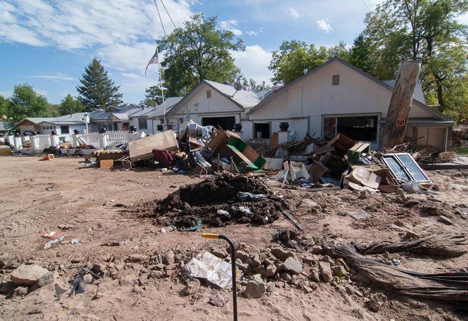
There was no running water, no electricity, no internet and no phone service. About 20% of the town’s housing was destroyed, Simonsen said.
Although Lyons didn’t look like a town anymore, Farjardo-Feaux said the community really came together. There was even a community barbecue to use the food that would have gone bad.
“Lyons was a town where people are so happy all the time having music and people and all. There was a feeling that like, OK, everything is gonna be good, things are gonna be OK,” she said.
During those first couple of days, Simonsen said the community, which was already close-knit, came together to survive the isolation.
“When you’re facing actual life and death situations, you get pretty close, and our community really pulled together,” Simonsen said.
Pelle said he made it a priority to get a declaration of a federal disaster as soon as possible to get funds for what would be an expensive search, rescue and recovery operation.
An emotional sight he remembers was when the National Guard units were sent from Kansas and Utah. He couldn’t believe the size of the convoy and the amount of equipment they brought with them, he said.
“It was just incredible, and it was a couple of miles long with a military police escort, and it’s like the cavalry had arrived,” Pelle said. “Then within a matter of days or weeks all those roads that had been washed out were at least temporarily recovered.”

The National Guard coordinated one of the largest air lift evacuations since Hurricane Katrina to get people out of the mountains, according to Pelle.
For Fajardo-Feaux and everyone in town, that was just the beginning.
Fajardo-Feaux and her family cried as they drove down the mountain, unsure of where they would go and for how long. They spent the next few months couch-hopping and staying in hotels and rentals.
When Simonsen told residents they had to leave, she had no idea how long it would take to repair the damage and put in utilities. It ended up being about seven weeks, and Simonsen said families started coming back by Thanksgiving, and most were home by Christmas.
But for those whose homes were destroyed, coming back to Lyons wasn’t in their future.

Road to recovery
The process of repairing and recovery was another mountain of challenge the communities had to face.
Where to even start — that was the first obstacle. But Simonsen and her team created a comprehensive plan that she now sends to flood victims across the country as an example.
The Federal Emergency Management Agency showed up in Lyons in October, and the town got to work putting in temporary utilities.
Simonsen said it was a difficult process, because the flood in Boulder County was different than others FEMA had dealt with. Permits, permissions and impact studies stood in the way of recovery.
Lancaster experienced similar challenges with Estes Park’s recovery. He said FEMA understood flooding in the midwest and coastal areas, where water rose and went back down, not where water rushed through destroying anything in its path.
Both communities had to fight for recovery of recreational attractions that fueled much of their towns’ economies — white water rafting features, trees, wildlife habitats and parks. These were things FEMA didn’t originally cover.
During the early period of recovery from the flood, Simonsen set a goal of being back to normal in four years. But Simenson said FEMA agents told her it would take much longer.
“I said, ‘No way, we’re really close, we’ll get it done.’ And they said, ‘No, you’re not understanding the financial part, this will be a six to 10 year event.’ And it was nine years,” Simonsen said.
The small town of Lyons was able to leverage $75 million in federal funds to recover from the flood, according to Simonsen. At the time, its annual budget was $1.2 million with $4 million in reserves. The recovery funds, though, are all reimbursement-based, and it is still waiting for reimbursement from the federal government for some projects.
Simonsen said there were very positive moments throughout the recovery process, but the community went through many low points.
“You start this rebuilding phase and then you, of course, have setbacks. They say anniversaries are usually low points for people where they’re reflecting. But, you know, very gradually you make your way back up. But it’s a long, long process,” Simonsen said.
One of those low points was when neighbors realized some people weren’t going to come back.
“At some point, you have to move on with your life if you aren’t able to rebuild,” Simonsen said.
The issue of affordable housing haunts Lyons. The flood wiped out the town’s mobile home park, Riverbend, and 32 families lost their homes there.
For Craig Ferguson, founder and owner of Planet Bluegrass, which hosts beloved bluegrass and folk music festivals in Lyons, the flood was an attack on his home and business. He decided to stay when the whole town evacuated and started right away on the road to recovery.
“Once you clean it up,” Ferguson said of his house in Lyons, “it’s pretty comfortable. I’d rather live here. I’d rather camp in my house and take showers elsewhere than go live somewhere else.”
Ferguson didn’t wait to ask for permission before getting to work on his Planet Bluegrass property. He said he had a deadline in sight to be open for the next festival in the summer.
Before him was about $2 million in damages, mountains of flood-deposited sand and damaged utilities.
So, Ferguson said he bought one of the last available backhoes in the state and got to work.
“We fixed up our place pretty aggressively and we just had to do it that way in order to survive,” Ferguson said.
Ferguson put on the bluegrass festival that summer as usual.
“That was the biggest celebration you can imagine. You know to the bluegrass world this is a pretty special place,” Ferguson said. “No one thought it would happen during the first two months, seeing the pictures, even most of my partners (said) we couldn’t do it.”
Lancaster said during this period, people’s creativity really shined.
He said the Estes Park community also came together and during its annual Thanksgiving parade, when people decorated their neighborhood-assigned Porta Potties to bring some joy to the difficult times.
“You know, people could be really frustrated and angry instead, but they said my Porta Potty is prettier than your Porta Potty and they decorated them and some of them put them on wheels and brought them in the parade,” Lancaster said.
Estes Park took severe hits to its roads, especially up the Big Thompson Canyon, which was severely damaged during the flood of 1976, when the road was completely wiped out. It was rebuilt with a promise it was floodproof, but in 2013 it was again wiped out.
The water undermined the canyon walls and rockslides completely covered the roads in certain areas.
“There was a section down in the Big Thompson in the narrows where you couldn’t tell there was ever a road there,” Lancaster said. “It wasn’t like the road was missing or damaged, there was no road and there was no sign of it either.”
Lancaster said he remembers after the 1976 flood the road wasn’t back to normal for years, so he could not imagine the road being back up for a while after the 2013 flood. But crews got U.S. 34 repaired by the new year.
“They got it up, and they did it right this time, and that’s why they made so many changes. They worked a lot on making the road a lot more resilient,” Lancaster said.
He said resiliency was their priority. Everything was about how to repair and make infrastructure more resilient. Bridges, riverbeds and buildings all went through a process to ensure the community could last through more floods.
“There’s still some other things we really need to do. We need to deepen this channel (along the local riverwalk) and have it handle more water. There’s a couple more bridges we need to replace even 10 years later,” Lancaster said.
For Lyons, Simonsen said the last flood-recovery project wrapped up in October, but she is still waiting for reimbursements from the federal government.
With the end of the last recovery project, she said the town can finally move on.
“Now that the projects are actually all done, we can actually kind of close that chapter, but we will always be recovering in different ways,” Simonsen said.
The town plans to hold a commemoration and remembrance of the flood this year for the 10th anniversary.
Simonsen said, however, community members remember the flood in different ways. For some, every time it rains they get nervous. Others still hold a barbecue on the night of Sept. 11, like they did 10 years ago.
Simonsen said she knew she had to see the recovery through in Lyons during the last decade.
Now, she said the community can focus on other parts of town that need attention.
“Pretty much the rest of town was kind of neglected the last 10 years. So now we have lots of work to do on streets, sewer and water lines, where we simply did not have funds to put toward it the last 10 years,” Simonsen said.
The issue of affordable housing still looms over Lyons, which lost nearly all its affordable housing to the flood.
Many families couldn’t afford to come back to the community. With disagreements on how to achieve affordable housing, the town is just now starting to see less-expensive units come in.
Ferguson worked to provide affordable housing downtown at a property that used to be a bank. He worked with Habitat for Humanity to bring back people who lost their homes to the flood.
Recently, Simonsen said the town started on a project to get 40 units of affordable housing built on a property donated by someone who lives in Kansas and has land in Lyons. The first eight opened and more are due to open soon.
“The community thought there’s not going to be anyone left who wants to come back because people had to move, but I’m happy to say that over 30% were here 10 years ago,” Simonsen said.

Looking to the future
After the rebuilding and mitigation efforts, communities still consider what would happen if another event like the 2013 flood were to happen.
“It’s not a question of will this happen and will we be ready or even when it does happen again. Will it not be as devastating?” Lancaster said.
Prein, of NCAR, researches climate change’s effects on major weather events like the flood. He said if another low pressure system stalls over the Front Range, there is likely to be even more rainfall because of the effects of a warming climate.
“The answer will almost certainly be there will be way more rainfall, because it’s really this moisture that you get from the south from the Gulf. Moisture increases with warming,” he said.
Researchers are not certain about how climate change affects the likelihood of cut-off low pressure systems, he said. But, if one does happen again, it is likely to be more devastating.
Colorado authorities built bridges higher, moved buildings out of the floodplains, carved further into the mountains to lay roads, and completely rebuilt stream banks. Yet, Simonsen, Lancaster and Ferguson all said another flood will happen, and they can’t fully prepare for what it will bring.
“What you try to do is minimize the risk, but you can’t avoid the risk, there will always be risk, and you have to balance that with the other needs of the community,” Lancaster said.
Preparing for the damage that comes with flooding of that magnitude isn’t possible, but in the last 10 years communities focused on mitigating what risk they could.
“It’s been a wonderfully challenging 10 years, and I think my goal always as a city manager is you leave the community better than you found it, and I think we did,” Simonsen said.